13 minute read
U.P. MICHIGAN REGION


Calendar
Nov. 18 Ironwood – Jack Frost Festival Tree Lighting Nov. 26-Dec. 5 Crystal Falls – Christmas Tree Galleria Dec. 4 Iron River – Christmas in Lights Dec. 4 Ironwood – Jack Frost Festival Parade Dec. 11 Crystal Falls – Crystal Christmas
You Betcha, Eh? We’re Going to the Jack Frost Festival
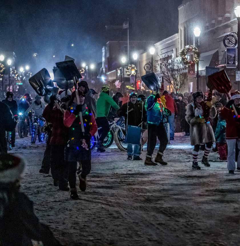
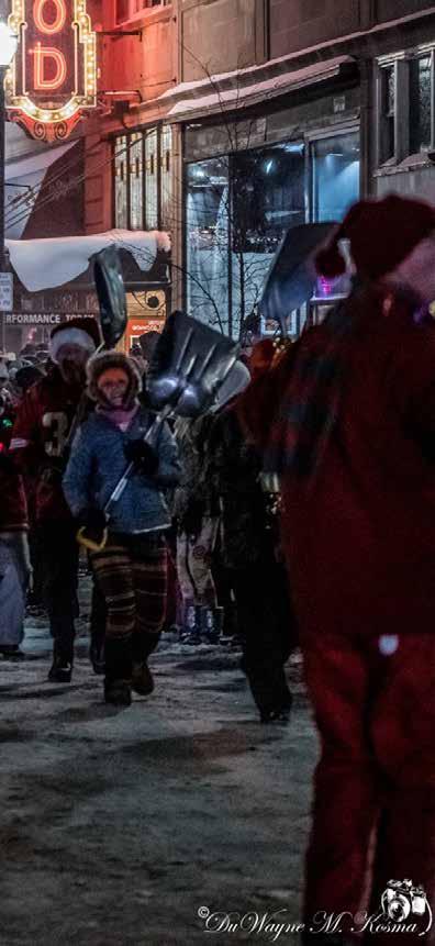
IRONOOD -- In the U.P., “Jack Frost nipping at your nose” is more than just a fireside song image, it symbolizes the beginning of the winter season—and snow! Throughout October and November, the brilliant fall foliage drops to the ground, the chill winds blow, and Jack Frost appears (on your car windshield and other places), heralding the arrival of winter. And winter in Michigan’s Upper Peninsula is a time of fun, celebration, and real “U.P. North Action.” For over 25 years, the town of Ironwood has had a “Jack Frost Festival” — a group of community events running from Nov. 18 to Jan. 29. Snowmobile races, ski and snowshoe races, winter-themed music and art, and, of course, the famous downtown Ironwood Jack Frost Parade on Saturday, Dec. 4, at 6 p.m. There is nothing like being bundled up and cheering on a full-scale outdoor winter parade! It offers real proof that Jack Frost does indeed nip at your nose. The Jack Frost Festival starts with the Old Depot Park Christmas tree lighting event on Thursday, Nov. 18, at 6 p.m. Folks near and far gather in the snow at the base of the Depot big pine tree for opening speeches (and you betcha, eh? they are short!), Christmas and winter music sung by a choir, and then the illuminating of the giant Jack Frost tree. Hot cider and treats follow inside the Historic Ironwood Depot. Often, Jack Frost makes a personal appearance at the event, disguised as wind-blown snow. A scant 16 days later, on Dec. 4, the Jack Frost Festival of Lights Parade kicks off at 6 p.m. Different from your usual summertime parade, the Jack Frost/Christmas theme showcases brilliantly lighted floats, massive trail groomers, decorated tow trucks, marching H.O.P.E. animal shelter dogs with lighted collars, Fat Tire Winter Bike Club riders, and of course, the dazzling marching performances of the famous Ironwood Precision Snow Shovel Drill Team! A parade visitor tip: make your lodging accommodations early. A listing of the Jack Frost Festival events can be found on the Ironwood Chamber of Commerce’s Jack Frost page ironwoodchamber.org/jack-frost-festival/. You can also like the Festival Facebook page facebook.com/JackFrostFestival and keep up with the latest news.


‘Yooperlites’ Can be Found on the Shores of Lake Superior
What are all those people doing on the beach after dark?
In 2018, Michigan gem and mineral collector, Eric Rintamaki, was searching for rocks on the shore of Lake Superior when he made what he called a “mind blowing” discovery. Resting among the thousands of pebbles covering the beach, he saw a glowing rock, a florescent orb that he later named “Yooperlites.” Like lava glowing through cracks in the earth, a glowing light seeped out of the lines in the small rock. Eric couldn’t find any information about glowing rocks online. He knew many people in the gem and mineral field, but everyone he asked had no clue what these mysterious rocks were. He went back to the beach night after night, carrying a black light which helped illuminate the glowing rocks and began collecting them by the bagful. Michigan State University, along with the University of Saskatewan, researched the Yooperlites. They determined that Eric did discover a new type of rock. He said that other people may have spotted these gems, but he was the first person to get Yooperlites verified. Michigan State gave the rocks a scientific name: syenite clasts containing fluorescent sodalite. The name Eric gave them – Yooperlites – comes from the nickname “Yoopers,” which refers to people who live in Michigan’s Upper Peninsula. Lake Superior is known for its rocky bottom and stoned-lined beaches. Many of these rocks were brought down from Canadian glaciers centuries ago and deposited throughout the lake and shore, which has made the Northern Michigan shoreline a haven for rockhounds. If you plan on searching the water for Yooperlites, make sure that your UV light is waterproof and that you are prepared for the extremely cold water of Lake Superior, even in August the water averages 65F. The best time of year to search for Yooperlites is in the fall and early winter as the storms and waves produced by the lake create a turbulent force that can alter the beach and shoreline daily. Early spring is also a great time to search for Yooperlites because the flake ice pushes against the shore and causes a good amount of erosion, exposing new rock layers to search. Since it takes using a UV light to help locate Yooperlites, searching from dusk to dawn will always yield the best results. It’s an added benefit to go hunting for the glowing rocks on a cloudy night while there is no moon or stars. This will increase the odds of seeing the UV light bounce off a Yooperlite because the beam of light will be stronger and your eyes will not need to adjust as much from the interference of the moonlight.

FeLiveLife.org: Find Your Element
The Gogebic Iron Range is a pretty incredible piece of real estate waiting to be explored. Born of volcanoes, seas and towering mountains of eons ago, the iron range stretches across Gogebic County in the Upper Peninsula of Michigan and through Iron County in Wisconsin. Its vast iron ore reserves drew miners and railroads and finally saw the development of communities on both sides of the border between the two states. More than a decade ago, community-minded citizens saw a need for one-stop info place to let visitors and locals know about the many recreational opportunities here, as well as the festivals and other events that populate all 12 months of the calendar. The group incorporated the scientific symbol for iron (Fe) in its name and as a symbol for the Gogebic Iron Range. FeLiveLife partners included a dynamic mix of representatives from municipalities, chambers of commerce, small businesses, as well as citizen volunteers. FeLiveLife.org debuted in 2010. It offered a suite of directories to local parks, trails, businesses and events. The publication and website showcased the Gogebic Iron Range as a great place to live, play and work, inspiring a new sense of community pride postiron mining. FeLiveLife partners wanted to show everybody that the diverse landscape provides excellent opportunities for outdoor recreation that greatly contributes to the quality of life. In some cases, the old mining scars became outdoor recreation centers, an amazing silver lining for a boom-and-bust economic history. In 2017, FeLiveLife.org refocused itself into an easy-to-use community calendar for the Gogebic Iron Range. The outcome of the collaborations was a well-rounded representation of community events that inform both locals and visitors. The website is maintained regionally, a point of pride itself! As long as there are woods and water to explore -- and communities to care for them – you can count on FeLiveLife.org to point you in the right direction!


Discover the Amazing Gogebic County Shore
By Dennis Fearson
Gogebic County’s Lake Superior shoreline is only 30 miles long, but there is so much family vacation adventure waiting there, along the water, as well as the first mile or two inland. Start at the west end, where the Montreal River drops over Superior Falls only a couple hundred yards from Lake Superior. Here the Montreal River is the dividing line between Michigan and Wisconsin, and the simplest way to find the falls is to travel north on WI-122 from US-2, until the road crosses the river, enters Michigan, and becomes MI-505. Once across the bridge turn left into the second gravel drive leading to a small Xcel Energy parking lot where two signs greet you, one pointing to the top of the falls, the other to the bottom. Take the short path to see the top view first. Soon you will be looking down at a wide waterfall dropping into the canyon on the other side. Headed towards the bottom of the falls we pass just above the generating plant, where the diverted water from the upstream dam has been carried by flumes. The trail to the bottom of the falls is steep but paved. At the bottom access to the pool beneath the falls is a tricky stepping stone river bank. A horn at the generator outlet gives adequate warning if adjustments at the dam would raise the river level. We all got our feet wet, but it was worth it. The climb back to the top is always daunting, and I’m happy that the single cable railing also serves as a hand pull. Back at the top a second short path doubles back toward the shore. The path ends at an overlook high on the sandstone cliffs. I can see Madeline Island in the distance. Just a couple miles east on MI-505 we turned on Powers Road and into the Powers Road Recreational Area. The area’s multi-use trails are considered to be some of the most scenic in the region. The county describes the area as “open to hikers or bikers to four wheelers or four legged modes of transportation.” There is also a significant snowmobile trail system. This day we chose to simply follow the Bald Mountain Scenic Drive, basically Powers Road. We stopped to take the half mile hike up an old “two-track” over the top of the ridge to the Bald Mountain overlook, a beautiful southern facing vista. Not only was the trail well marked there were educational signs on many of the trees, explaining their species and what they might be used for when felled. Back on the Scenic Drive we came to a second overlook, this one facing to the north. We could see our next objective in the distance, Little Girl’s Point. The scenic drive ends as it began, at MI-505. We backtracked to get to the shoreline we had seen from above. The long curving beach at Little Girl’s Point is beautiful to see, but nearly impossible to walk on. It’s not sandy like other area beaches, but covered with a deep layer of fist-sized rocks. My grandkids spent some time trying to refill the lake by throwing back rocks from the beach, but were disappointed that most were too heavy and round to make good “skippers.” It had been a busy day, and a meal was called for. But, as along much of the Upper Peninsula’s rugged and unpopulated coast there is no road along the shore, and away from cities finding nearby food or fuel can be difficult. We returned to town to plan our next day’s adventure along the Black River Scenic Byway.
Black River Scenic Byway
Going north on MI-513 from Bessemer the route twists through the town and ski area, but once past Airport Road there is no way to get lost as the highway goes directly to the harbor and back. About eight miles north of Airport Road a fork to the right leads you to the base of the Copper Peak, the highest ski jump in the western hemisphere. At this height it is call Ski Flying. When you first see it, it’s a little scary, but getting to the top is a must do! We purchased our tickets at the visitor’s chalet before heading to the chair lift loading platform. My granddaughter was a little nervous of the chair lift that was going to carry us up the first 800 feet of this copper bearing volcanic outcropping, but she slid onto the chair anyway, and by the time we approached the first lift tower the smooth and quiet ride had calmed her. Grandma, who dislikes cable rides of any kind, took a deep breath and rode up with our youngest “no fears” grandson. After stepping off the chair at the top, there’s a short walk to the jump’s single leg, actually an 18-story elevator tower to the viewing platform. Even Grandma felt safe on the concrete and steel platform, but the now calmed granddaughter challenged me to a race to the top, eight stories above. I was no match for her young legs, but in a few minutes, we were both leaning on the railing, 26 stories above the ground, snapping photos of the unobstructed view: 2,500 square miles, three states, and pretty sure that the hazy bumps on the horizon across the lake were in Canada. You don’t want to start down, but we had to, there was much more to see. Back in the valley we agreed on the “Peter Pan like” feeling we felt as the lift seemed to float us to the ground. There are five amazing waterfalls along the road between Copper Peak and the harbor. The National Forest has provided signage and parking for each. We stopped at Potawatomi which shares its parking with Gorge Falls. The two are connected by a complicated system of stairs and elevated board walks. We voted and decided that we would visit the others on our way back if there was time and then headed towards the harbor. In the center of the river edge Black River Harbor there is a long and sturdy suspension bridge built decades ago by the CCC giving access to the miles-long sandy beach. The final stop on our Gogebic County Shoreline tour was to be the waterfalls of the Presque Isle at the far west end of the Porcupine Mountains State Park. They were only five miles by hiking trail from where we stood, but again the rugged and thinly populated Upper Peninsula lacked direct access by road. The 45-mile drive back to US2, then east, and finally north again on MI-519 took nearly an hour. Now energy packed with food and a restful ride, we chose to leave the truck at the South Boundary Road Bridge over the Presque Isle River, and walk the last 2/3rds of a mile or so to the lake shore. The West River Trail is mostly boardwalk, and passes by each of the three named waterfalls, Nawadaha, Manido, and Manabezho. Not far from the mouth of the river a suspension bridge leads to a peninsula that becomes an island during periods of high water, giving the area its name. Presque Isle can be translated to mean “almost an island.” Between the bridge and Lake Superior, over the eons, spinning rocks have ground deep, steeply sided circular holes into the river’s granite bottom. Curious to see, but dangerous traps when high water hides their existence, this area has become known as The Kettles. Excited as I was to see these wonders for the first time, grandkids are only impressed for a few minutes. Anxious to return home the kids urged us back along the river trail to the truck. Like batteries going dead, there was silence from the back seat almost before we were out of the park.


Adventure awaits!
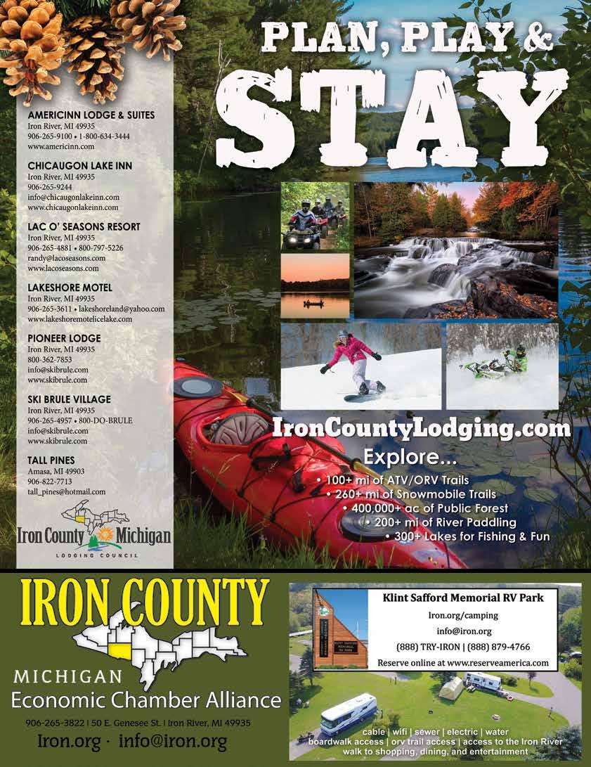
• Mil of ATV/UTV trails • Bounti l shing • Hiking/biking trails • Camping adventur • Plus SO MUCH MORE!


Ironwood Chamber of Commerce
150 N Lowell St. Ironwood, Michigan 49938 1-906-932-1122 chamber@ironwoodchamber.org ironwoodchamber.org facebook.com/IronwoodChamber/
Lake Gogebic Chamber of Commerce
PO Box 114 Bergland, Michigan 49910 1-888-464-3242 info@lakegogebicarea.com lakegogebicarea.com facebook.com/lakegogebicarea
Wake eld Chamber of Commerce
Travel Ironwood
M-28 at US-2 Wakefi eld, Michigan 49968 PO Box 93 1-906-224-2222 chamber@wakefi eldmi.org wakefi eldmi.org
travelironwood.com
UpNorthAction.com | Aug/Sept 2021 39