


+44 7384707652
pin.chen.22.ucl@gmail.com
NW3 5HS
Flat 4, 142 Finchley Road, London
I am passionate about crossing architecture, urban and landscape barriers, and solving how climate change impacts ecologies and societies.
One of my main interests is architecture and ecological dynamics. I am interested in how ecologies are shaped, structured and changed and its implications for contemporary architecture and society. My research examines how architecture and landscape influence the process of energy production, from providing political institutions, and public forums to ecological spaces that can mitigate the pollution.
UCL, Bartlett School of Architecture Master of Landscape Architecture (MLA) Potential chemical polluted soil mappings | Marine ecology studies | Endangered plants in Russia and Norway studies | Drainage studies | Construction detail drawings | GIS mappings for site conditions | Water network simulations | Coastal flooding risk assessment | Social & Ecological infrastructure
National Taipei University of Technology Bachelor of Architecture (B. Arch)
Merging the concept designing for multi-scale projects, including product design, speculative design and architecture.
Bartlett Autumn Show 2021 & 2022 Exhibition
Bartlett Development and Planning Unit Winter Lab
Mapping research and providing the scheme of potential urban regeneration with ICCR partners and UCL DPU scholars regarding the war's impact on the city of Aleppo, Syria.
TAGather & Rebirth Architects: Architectural Assistant
- Housing Design
Facade and interior concept Design | Drawing and physical modelling | Measuring the site to gain an evidence-based site model.
- Factory Regeneration Songshan Cultural and Creative Park Boiler Room, Taipei City, Xinyi District Concept Design & Modeling for the building facade and extended pavilion | Guidelines and user research for the future events.
Taipei Fine Arts Museum X-site Competition | Final Phase of Election
Project narratives developing | Source out and select all materials and suppliers | Developing architectural design from design concept to final design documentation | Construction drawings of the bridge and lighting installations.
Wun-Jie, AXB Architecture Studio :Architectural Intern
Hsingchu East Gate physical model making | Nantou Church concept design |
Taipei Teacher's Hostel 3D modelling | Huashan Pavilion physical model, facade | • SKILLS
LANGUAGES English (Advanced) | Mandarin (Native)
3D MODELLING Rhino | Houdini | SketchUp | Grasshopper | Blender |
RENDERING V-ray for Rhino | Lumion | Unreal Engine | Keyshot | Enscape
GRAPHIC Adobe Creative Suite Photoshop | Illustrator | InDesign
OTHERS ARCGIS | QGIS | CloudCompare | Autocad | BIM |
London / UK
Sep 2020 - Sep 2022
Taipei / Taiwan
Sep 2015 - Sep 2019
London / UK
Oct 2022 - Nov 2022
London / UK
Oct 2021 - Nov 2021
Content
0 1 Parliamentary Landscape : Decoy, Debate, Deconstruct
Project Type: Landscape Architecture
Year: 2022-23
0 2 The Third Pillar : Speculative Garden
Project Type: Landscape Architecture
Year:2022
0 3 Border Vague : Revealing the Buried Epistemology of the Mining Town along Russia-Norway Border
Project Type: Landscape Architecture
Year:2021-22
0 4 Locality & Mobility : Living Museum
Project Type: Architecture
Year:2018-19
Taipei / Taiwan
Feb 2018 - Mar 2019
0 5 Thesis: Making Things Parliamentary Project Type: Architecture
Year:2022
0 6 The Duality of the Cave
Project Type: Competition
Year:2019
Taipei / Taiwan
May 2019 - July 2019
Taipei / Taiwan
April2020 - Jun2020
Parliamentary Landscape : Decoy, Debate, Deconstruct
Site: Sizewell Power Station (UK)
Year: 2022
Work Type: Individual Work
Institute: UCL, Bartlett School of Architecture MLA
Status: Conceptual
Instructor: Matthew Butcher, Tiffany Dang
Keywords: Public Assembly / Landscape / Architecture / Protest Avenue
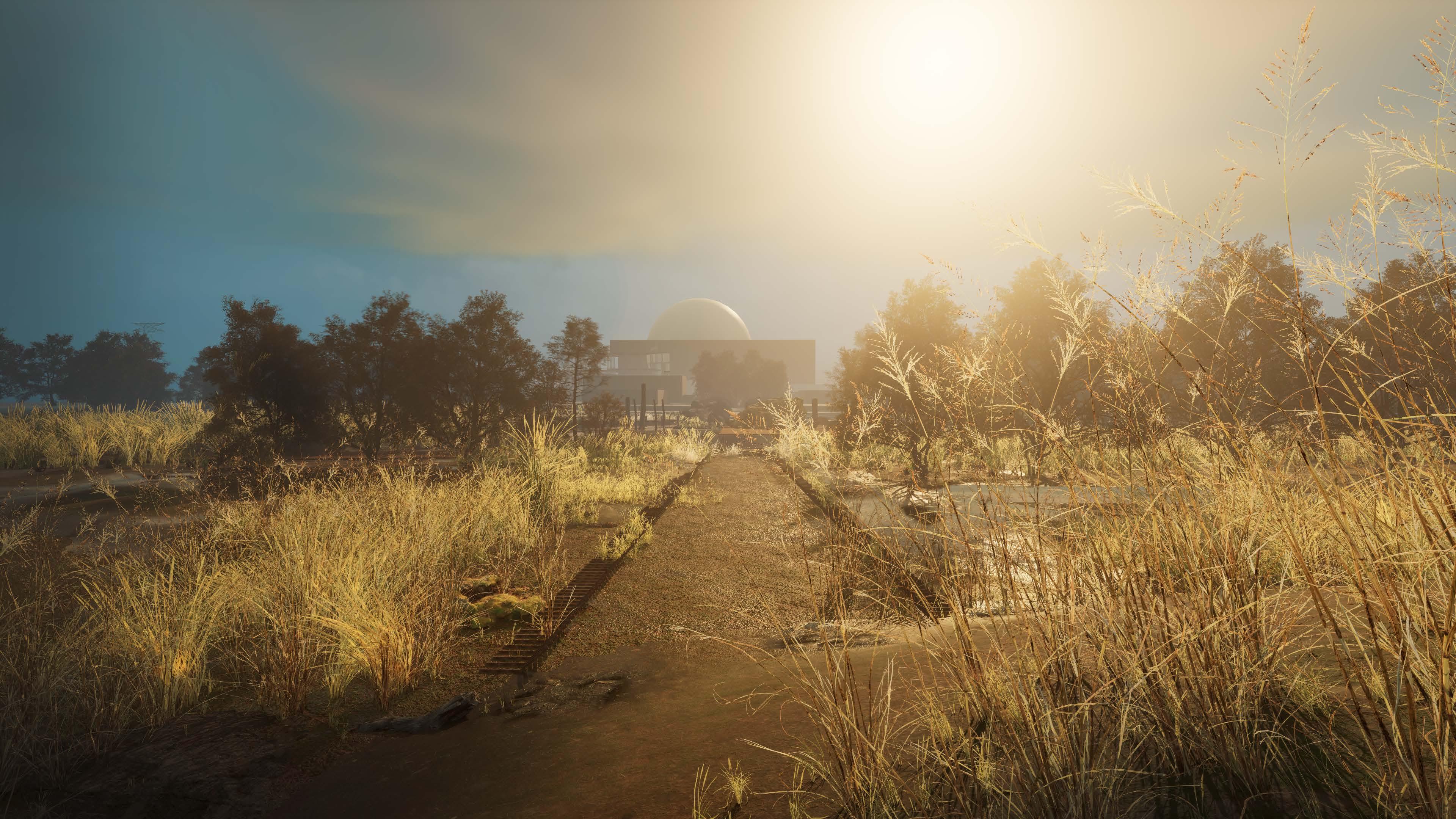
The proposed expansion of the Sizewell nuclear power station in Suffolk has been subject to much local controversy, objection, and debate. Inspired by the Þingvellir Parliamentary Landscape in Iceland, this project proposes to design a number of social and ecological infrastructures within the Sizewell region to facilitate discourse and discussion on the future of nuclear power. The design of these ceremonial meeting spaces may point toward the democratisation of the decision-making process and test the existing conventions of what forms a parliament can take.
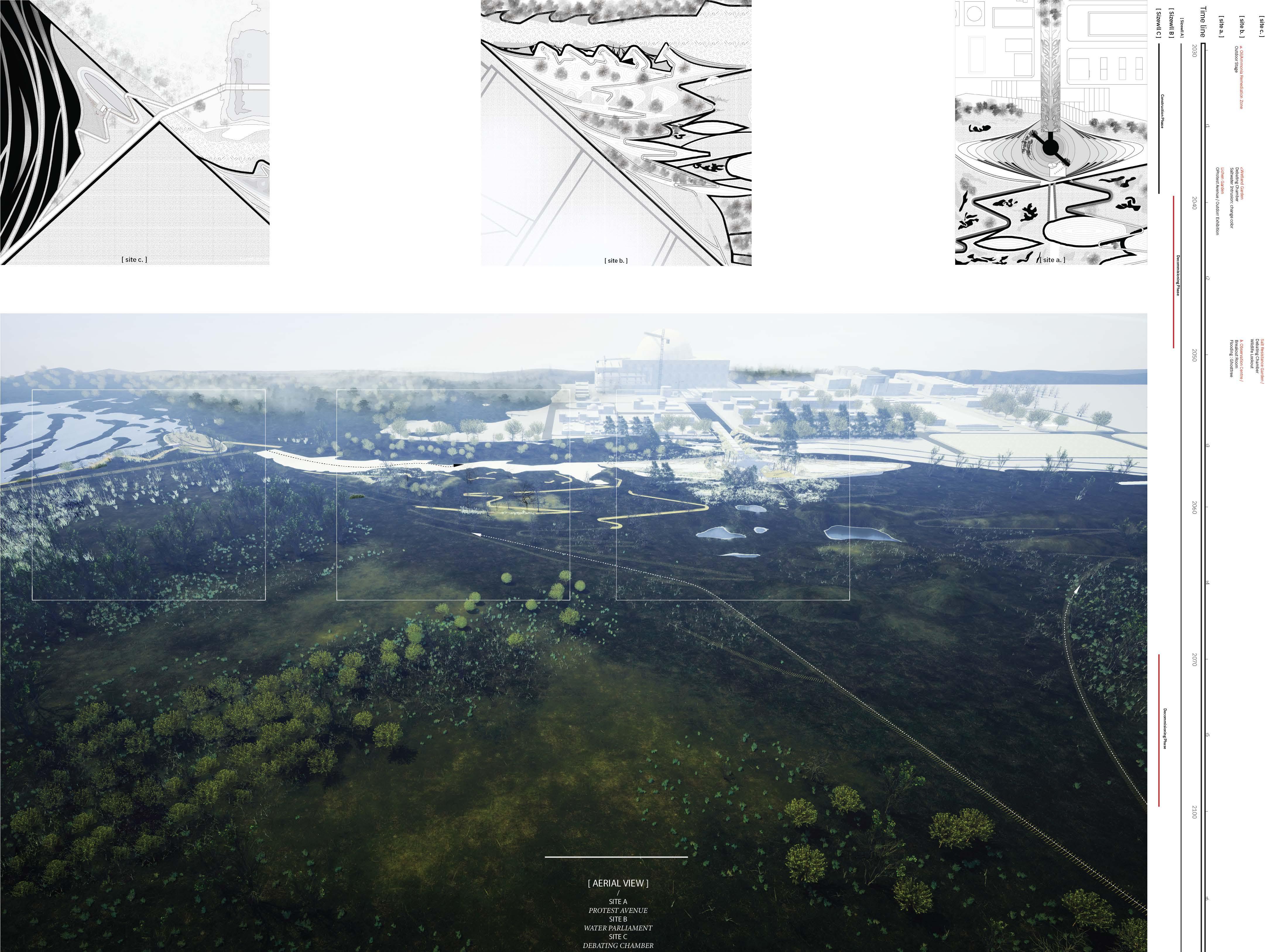
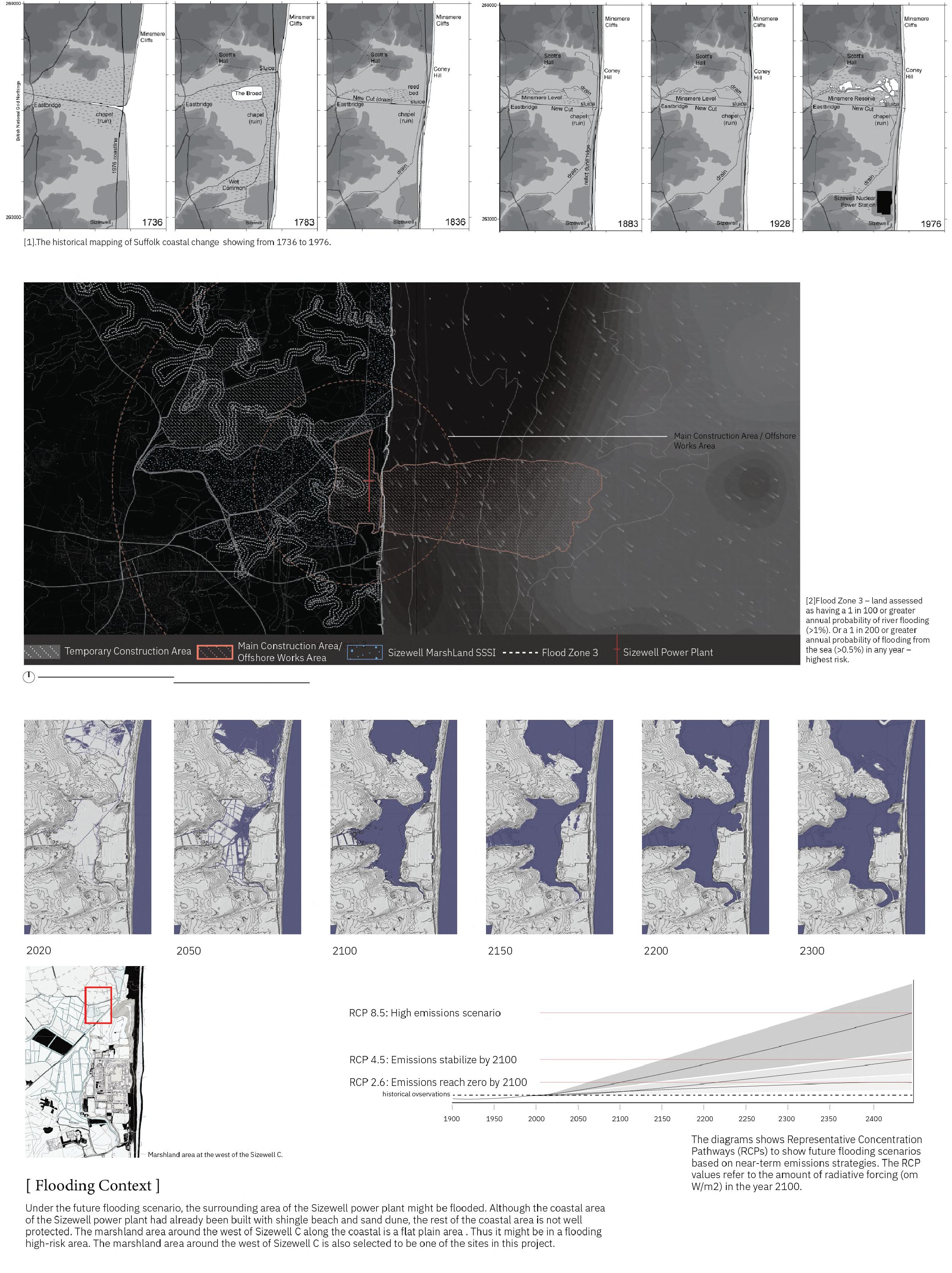
The marshland area around the west of Sizewell C is selected to be one the the site in this project.Under the future flooding scenario, the surrounding area of the Sizewell Power Station will be flooded. Although the coastal area of the Sizewll had already been built with shingle beach and dune to protect the flood but the rest of the coastal area is not well proctected. The marsh land area around the west of Sizewell C along the coast is a flatplain area. Thus, when the flooding happens, it might intrude through this high rist area.

Aquatic vegetation of the Sizewell Marshes dykes, in 2007, the survey has shown that the dykes are vulnerable to potential contaminants and also the possible impacts of change in hydrological conditions.
Sizewell Marshes are improtant for the large area of woodland, unimproved wet meadows(fen meadow), reedbed, ditches with diverse aquatic flora and wet woodland which support outstanding assemblages of invertebrates and breeding birds. Several nationally scace plants are also present.
Some of wooden areas are ancient woodland our boulder clay overlain by sand. The site is the most interesting example of the sloping type of East Suffold Hornbeam wood. It has a rich flora, including ancient woodland plants and one scarce species the rare thing-spiked wood sedge(Carex Strigose).
The historical Suffolk coastal change showing from 1736 to 1976. Mudflat Plants Woodland Woodland Woodland Fen Meadow Fen Meadow Saltmarsh Plant The diagram shows Representative Concentration Pathways(RCPs), showing the future flooding scenarios based on near-term emissions strategies. The RCPs values refer to the amound of radiative forcing in the year 2100. Flooding ZoneWhen the saltwater intrusion occurs, the herbaceous sea blite and common glasswort would change the color to be red, demonstrating the enviornmental chnaage and remind scientists to test the environment.


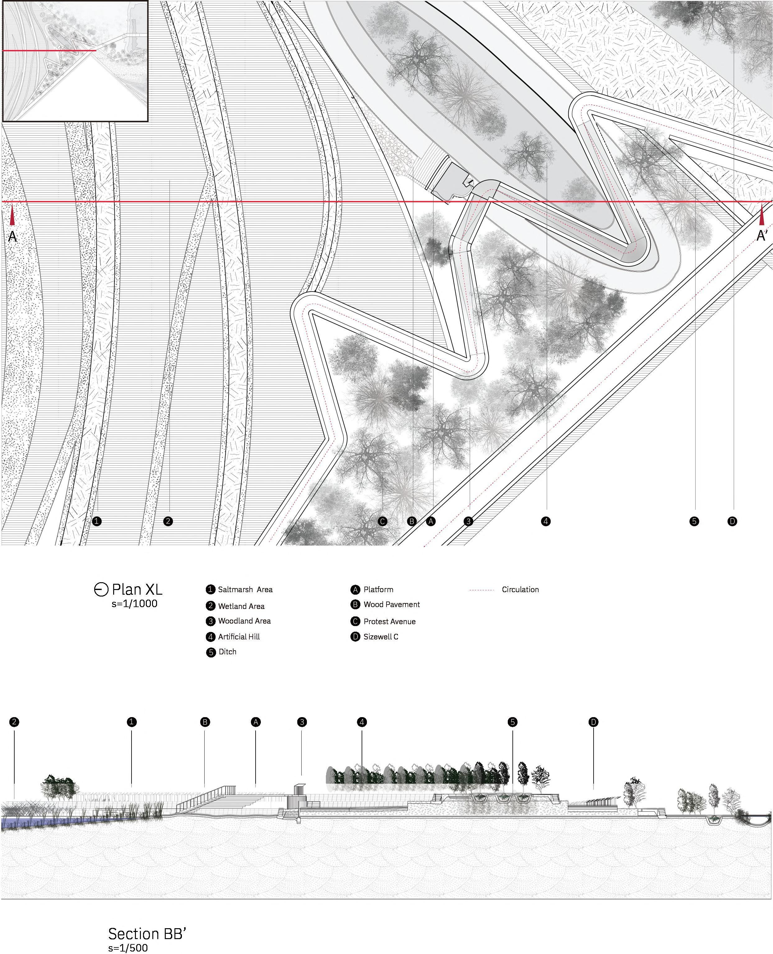

The oakmoss lichen is sensitive to nitrogen in the air. The lichen become the testing plants to measure the level of the polluttion in the air.


 Lichen Garden
Time Line: 2030-2040
Events: Oil / Amonia Leakea
Function: Protest Avenue / March, Lichen Garden

Endoliths
Euendoliths
Cryptoendoliths
Epiliths
Hypoendoliths Antoendoliths
Chasmendoliths Hypoliths
Register of Change Rock garden in this section represents the main refuge for life in the extreme environment. The extreme environmental niches become an outdoor biological exhibition room and the observation points for participants and users.
Lithobiontic Communities: The community is an accumulation of micro-organisms at an interface forming a biolilm, which interacts with the lithic substrate both geophysically and geochemically.

Time Line: 2040-2050
Events: Flooding
Function: Protest Avenue / Marsh, Lichen Garden
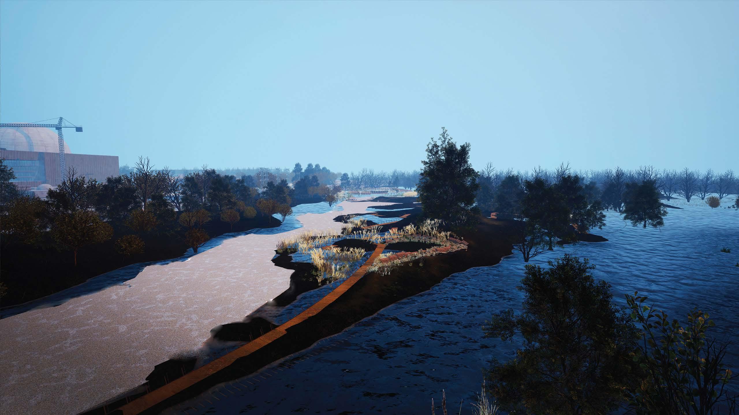


Time Line: 2070-2XXX
Events: Flooding
Function: Salt Resistance Garden / Water Parliament


Marsh Area

-Sea Purslane (Sesuvium maritimum)
-Sea Thrift (Armeria Martima)
-Climbing Corydalis (Ceratocapnos claviculata) The area introduced the salt tolerant plants to adapt future salt intrusion from both floodig and salt ground water.
Sea Purslane (Sesuvium maritimum)
-grow in 5 weeks usually ssed in winter and group up in the next spring
-When the weather turns extremely hot or cold, not well fed and fertilised, or the soil is poor. These kinds of succulent when experiences on or more of these conditions the plats is under stress. Thus hte plant is reacting to the extremes in the environment by exhibiting these color changes.
Sea Thrift (Armeria Martima)
Climbing Corydalis (Ceratocapnos claviculata)

Time Line: 2070-2XXX
Events: Flooding
Function: Salt Resistance Garden / Water Parliament

The Third Pillar : Speculative Garden

Area: Blackfriars
Year: 2022
Work Type: Individual Work
Institute: UCL, Bartlett School of Architecture MLA


Status: Conceptual
Instructor: Matthew Butcher, Tiffany Dang
Keywords: Phytoremediation/ Biomimetic/ Installation / Garden
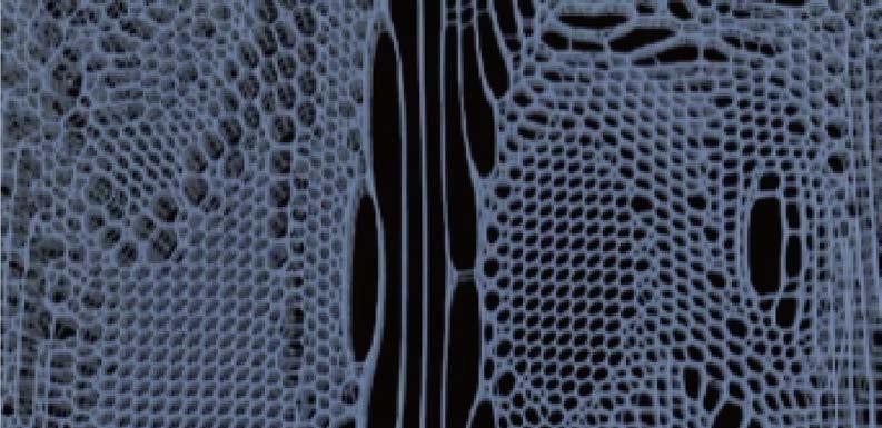
The aim of this project is to purify the contaminants from the Thames River using a sustainable and ecofriendly method. The proposed solution involves introducing plants to grow on net structure surface materials. By introducing multiple microbial communities, competition for survival is enhanced, which can lead to better adaptation. For instance, phototrophs such as algae and cyanobacteria can survive on inorganic material. As they thrive, heterotrophic organisms such as mosses and lichen can further grow on the net structure column, thus enhancing its phytoremediation capability.
In addition to the environmental benefits, the column garden would also serve as a bankside platform for archaeologists and biologists to conduct research on the Thames River. Overall, this project offers a sustainable solution to purify the Thames River while also creating a space for scientific exploration and research.


Border Vague : Revealing the Buried Epistemology of the Mining Town along Russia-Norway Border

Area: Norway–Russia border
Year: 2021
Work Type: Individual Work
Institute: UCL, Bartlett School of Architecture MLA
Status: Conceptual
Instructor: Matthew Butcher, Tiffany Dang
Keywords: Borderscape / Landscape / Architecture / Bridge / Recreational Centre / Garden
Sited on the border between Norway and Russia, this project reconsiders the autonomy of the town of Kirkenes. The region has a complex history of territorial dispute and mineral extraction, attracting investors from the globe to invest, extract and occupy. As a result, this area has become a semi-peripheral place to Norway. Mining extraction in Kirkenes sparks land use debates between Sámi claims to traditional territory and the mining site. This complex geopolitical context leads to a focus on the border area where multiple actors meet: Norwegian, Russian, and Sámi. This project proposes a series of endangered plant gardens and a meeting space where politicians and other actors can debate geopolitical issues and socio-political issues.

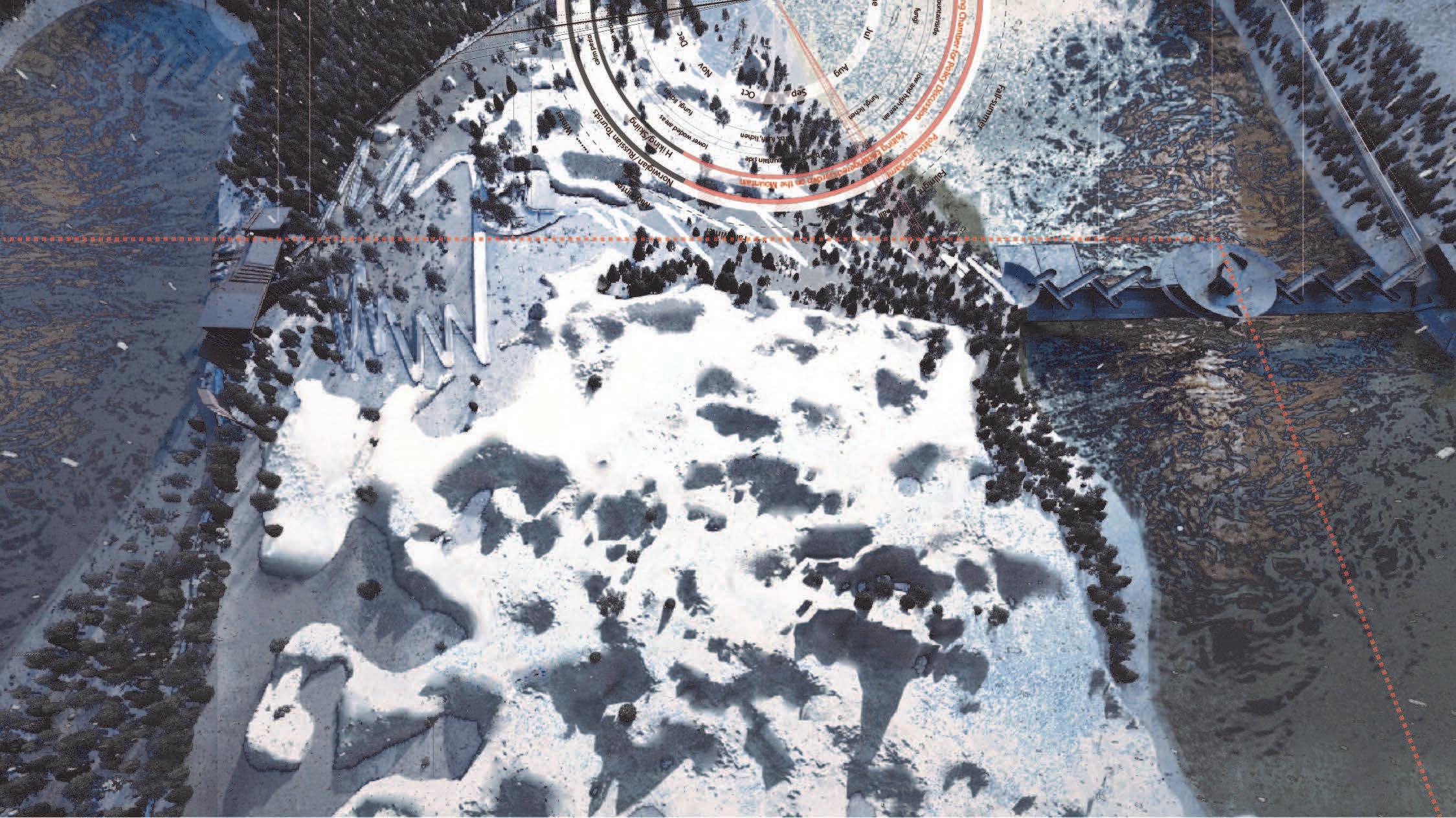 Aerial View of the Site


Midwinter
Spring-winter Spring Summer

Recreation Centre
Endangered Plants Garden / Wet Mire Area
Marsh Earwort (Jamesoniella undulifolia)
Hiking Trails / Skiing Place
Terrestrial Lichen Recovery Garden / Sparsely Vegitated Area & Forest Area
Orthodontopsis (Orthodontopsis bardunovii)
Lichen Recovery Garden Debating Chamber
Endangered Plants Garden / Sparsely Vegitated Area
Orthodontopsis (Orthodontopsis bardunovii)
Chosenia(Chosenia arbutifolia)
Scapania (Scapania nemorea (Orthotrichum scanicum) (Mamillariella geniculata)
Scapania (Scapania nemorea)
Chosenia(Chosenia arbutifolia)
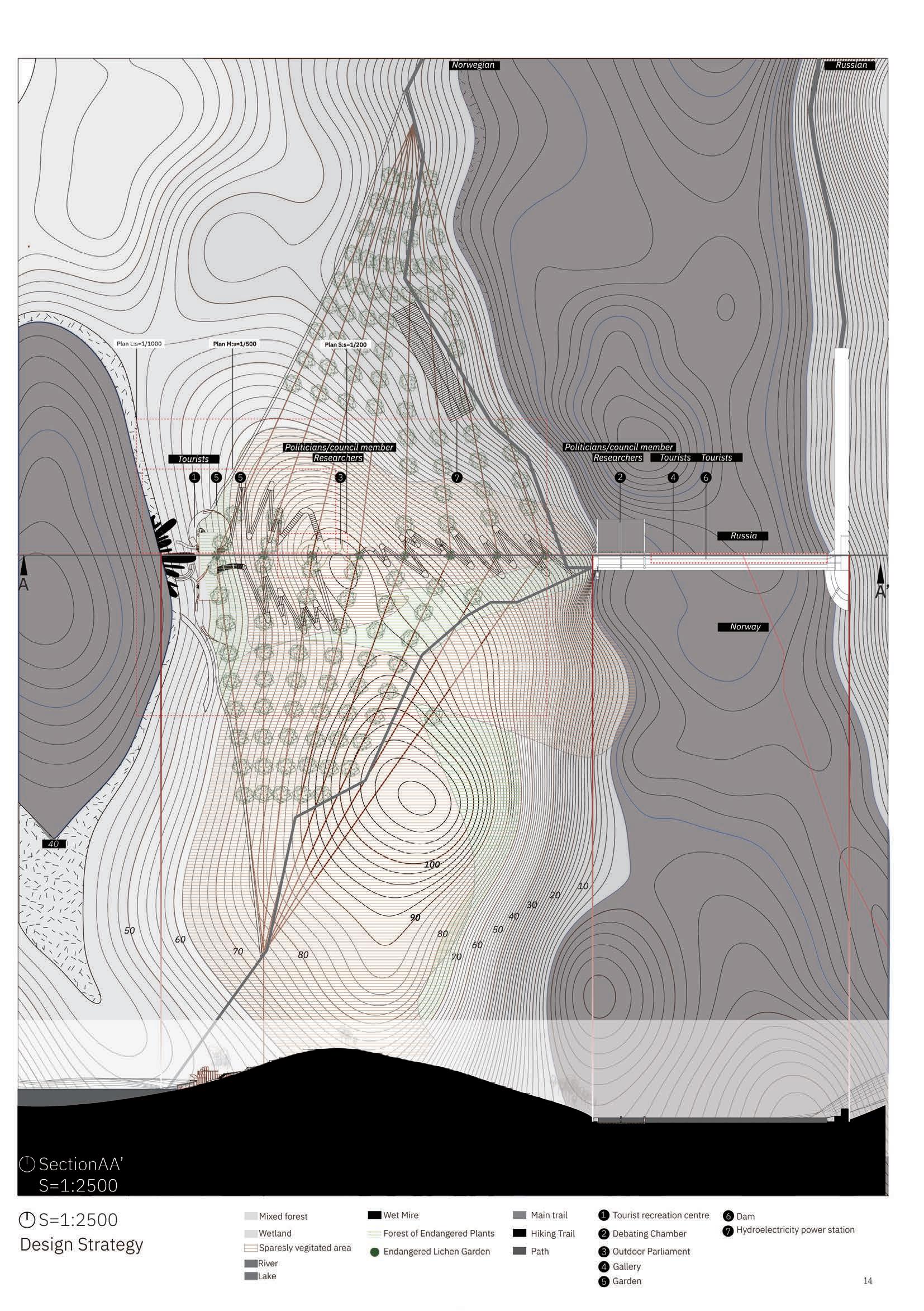


In the wetmire area, the coastal area used the terrafix blocks to provide effective protection against wind and water erosion.
The units of blocks area available in two different thicknesses and can be laid in a variety of conigurations to suit most site conditions, including water courses, lakes, roak works, railways, mairne works, and rehabitation of mine tailing slopes.
The blocks are applied into the wet mire area, supporting the fan-shaped pits where cultivated series of peat bogs and marsh earwort.
TOURIST VISITING PLATFORM
ENDANGERED PLANTS GARDEN
TOURIST VISITING PLATFORM
PLATFORM
WET MIRE AREA
ROCK AREA
RUSTY STEEL PANEL
FOUNDATION

COMPACTED SUBGRADE
BIO-DEGRADALBE EROSION MATS
BLOCKS TO AGAINST RAPID DEGRADATOPM PF RIVER STREAMS

Observation Deck / Endangered Plants Garden


 [ River Area ]
Debating Chamber

Locality & Mobility : Living Museum
Site: Keelung Harbor, Taiwan
Year: 2019
Work Type: Individual Work
Institute: NTUT, National Taipei University of Technology
Status: Conceptual
Instructor: JIN HUA HUANG
Keywords: Museum/Office/Historical Pier
The project focuses on the revival of Xi-San Pier in Keelung. Office in this space elongates the life cycle of a building and continues to bring life energy to a historical building. Observing landscapes, places, and people while drawing on elements of the enclosure to respond to spaces with different scales brings a broader connection to the theory of The Expanded Field from Rosalind Krauss. The ground floor provides different sizes of offices, and the second floor is a museum.

Spatial Sequence


Work Type: Individual Work Institute: UCL, Bartlett School of Architecture MLA
Thesis Supervisor: Gillian Darley
T his dissertation aims to re-evaluate the concept of a political assembly. It scrutinises the original impetus of what makes the space from being gatherable to debatable. The deduction includes the notion of the ancient Thing/Þing space. Kullmann's "Thing-as-Matter" (2021) pointsv out the significance of how to self-governance in a specific landscape area. The ambition of the parliamentary landscape is to shift legal discourse, create new customs, raise the public debate on the controversial site, and reverse the political inequalities. The framework and critical thinking of the landscape and parliament are keen to build bottom-up political engagement.
While the parliament's function includes making legal discourses, debating issues, and verifying government spending, its ability to accommodate changing public gatherings has been limited by its traditional function. Under modern democratic and spatial frameworks, the parliament, as a semi-public infrastructure, provides limited public space for citizen engagement. It is unclear how the parliament can adequately reflect the demands of modern democratic politics. In this situation, the parliament buildings' role addresses the buildings' power restricted solely and substantially by the play of the architectural objects and their symbolic meaning. Hence, it needs to be more opportunities to discuss the broader issue of bringing things besides the building materials. Before parliamentary buildings were invented, Nordic politicians, leaders, and citizens gathered in outdoor spaces for public assemblies. These assemblies were based on the local
And yet, once we reopen the question of composition and representation, once we bring the cosmos back into politics, there is some wisdom in rejuvenating the old meaning of things. Yes, politics is also Dingpolitic, not because it goes back to some archaic foundation against the movement of modern life but precisely for the opposite reason: because the “objects” that had been thrown out of assemblies by the tradition of political philosophy are now back inside them. There is thus a crucial interest in shifting the centre of gravity of politics from an assembly of people to an assembly of matters of concern. After all, the prestigious phrase Res publica includes the word res, thing , and the pragmatic tradition has centred around pragmata, that is , things once again.”
landscape and retained cultural identities. Understanding the etymological meaning of the landscape and its relationship to the political and social spheres is crucial for examining how the parliamentary landscape can be formed from both environmental features and spatial functionality and why the landscape became parliamentary. Historically, the landscape has been used as a disciplinary ground to shape culture (O.E.D. 1971:shape). Nordic and Saxon regions follow the etymology of "Thing", where people gathered around the sublime natural landscape to discuss and debate political issues. The archaic root of this etymology demonstrates the social impetus from locals and the possibilities of what could be parliamentary(Latour, 2005).

The parliamentary landscape is a form of representation, a nexus of civil and political rights, cultural identity and representative performance from humans and environments. In line with that, the third chapter provides several examples of a parliamentary landscape. The parliamentary landscape could be surrounded by specific climate, energy, and ecological issues and merge topographically. Icelandic landscape parliament is a good example that endows volcanic landscape with multiple symbolic meanings, including law rocks and volcanic ground as an outdoor amphitheatre. Since it merges with the local landscape for an extended period, even if the architecture is demolished, the landscape represents the culture, epistemology, and customs.
[2]O.E.D. 1971. Oxford English Dictionary. Oxford University Press
Work Type: Team Work
Competition: Taipei Fine Arts Museum X-site Competition | Final Phase of Election

The outskirt in a city grows freely by its habitats. Compared to the structure of a city
that is regulated by a system, the city growing freely evolves naturally and changes the relationship between collective and individual, showing multi-faced realities, stimulating city views, while eliminating the old and generating the new. The Duality of Cave uses the allegory of the cave and observes the outskirts of a city to be the foundation to build a double-decker stage in the plaza of the Taipei Fine Arts Museum to showcase the dynamic of life. The Duality of Cave considers the lower deck of the stage as the regulated space that people experience and the upper deck as the ideal Form that naturally extends from the wills in life. Air conditioners that can be often observed in the outskirts of a city are presented symbolically and the visitors in the museum can view the whole stage through the glass wall. Hence, a conversation ensues among the three, upper deck, lower deck, and the visitors in the museum. Using the features derived from the outskirts of a city that is not regulated by a system and violates the laws, the Duality of Cave presents the most natural operation in a city and offers a medium to redefine and speak up for the existence of space on behalf of visitors. It also uses the idea of a city’s periphery to extend and eliminate the museum’s prospect.
The Duality of Cave echoes with the succession between the outskirts of a city and the existing architectures and achieves a balanced character. When visitors come in and out of the space this activity influences the succession of the whole environment; resultantly, the space is temporary and fluid and difficult to define, which disrupts the meaning of existence in architecture. The installation offers a medium to redefine and speak up for the existence for the visitors. The outskirts of a city have features that are outside the system and against the rules but are able to show the most natural operation of a city. This installation uses the idea of the outskirts of a city to interpret the museum’s prospects and reflect on possibilities for the ideal Form of a city.
