Come experienCe our Towns......
CommunitiesalongHighway126-fromtheedgeofSpringfieldtothewondersoftheCascades

This small McKenzie Valley community is the first you’ll encounter when entering the area from the west. In the 1800’s it was named for a cedar mill on the “flats” above the site of a former stage stop, located near the site of the first historic river crossing - Hendrick’s Ferry.


Unlike most of the area’s unincorporated communities that are sited along Hwy. 126, Camp Creek follows the McKenzie as it heads to the river’s confluence with the Willamette River. This stretch of stream includes some great angling in a fishery that’s open year ‘round.
Bearing the name of a pioneer family, this community is the home of the only shopping center in the Valley - which includes a restaurant, supermarket, feed and tackle store, and a U.S. post office. Want to see more - book a guided horse tour of the hillsides.


This small river town was famous in the days of the White Water Parade. Today it hosts the annual Wooden Boat Festival. This community is home to a resort, as well as the Nimrod Fire and Eastern Lane County Fire Protection District station.


Hwy. 126 passes through where this town was first settled, but much of its population has grown on the other side of the river. There, a residential community has developed in a new neighborhood. The area also hosts a county park, boat launch, and marine sales outlet.
A public library occupies part of an old schoolhouse here. This community is also home to a veterinarian, auto repair shop, store, and public library, as well as the headquarters of the McKenzie Fire District. Further east are Filbert orchards, also known as hazelnuts, and an organic farm.
From 1908 to 1911, a state salmon hatchery was located on Gate Creek. The eggs came from fish that were caught by weirs placed across the river near Leaburg Dam. The community now offers gas & groceries, a real estate office, a cafe, a post office, and a fire station. Milepost
A big rock, named for early settler Ben Finn, was the tag for this former company logging town. It’s now home to the Finn Rock Reach - focused on restoring riparian areas. Its newly updated boat ramp provides easy river access.
Once the nexus of those seeking riches in gold mines, Blue River is home to the McKenzie School District, a park, post office, a boat landing, and the Blue River Reservoir. Damaged by the Holiday Farm Fire, rebuilding is underway.


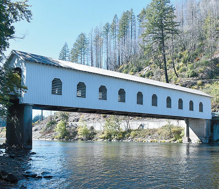
Rainbow can boast a variety of attractions including the Belknap Covered Bridge, resorts, a restaurant, RV parks, a motel, a country store/gas station, a community center, and an 18-hole golf course.
Early settlers called McKenzie Bridge “Strawberry Prairie” for its abundant berries. The community now includes restaurants, numerous resorts, two churches, a retreat center, a fire station, and a professional river guide.
Heading East of McKenzie Bridge Highway 126 travels through areas of geologic significance and the line of demarcation between the Old and New Cascades near Belknap Hot Springs. Deep beneath lava fields formed as little as 1,500 years ago is a huge aquifer that ensures the McKenzie River flows freely all year round.
CoverphotoofBlueRiverReservoirbyGeorgeShelley
© 2024 McKenzie River Reflections All rights reserved, including the right to reproduce this publication, advertising copy, or any part thereof in any form, including digital and artistic duplication of photos, maps, graphics, advertisements, or text - except for the inclusion of quotations in a review - without written permission of the publisher. Under no circumstances is permission granted to use this content in any artificial intelligence-related endeavor, including “training.”
McKenzie River Reflections, 59059 Old McK. Hwy. McKenzie Bridge, OR 97413 (541) 822-3358 mckenzieriverreflectionsnewspaper.com
Touring Scenic Byways in style
The best way to experience the River
Joyrides refreshyourself ourfinnyfriends getout&go

Routes with outstanding scenic, cultural, and historic elements can gain recognition, and travel ways in the McKenzie River area have been recognized, not once or twice, but three times.
One is the 34-mile McKenzie River Scenic Byway, which extends from Walterville to Rainbow. It follows along the banks of the river - from farmlands on the east to forests at its western terminus at Aufderheide Drive. From fresh vegetables to local honey or Christmas trees in season, people can stop and stock up at local farm stands.
Midway, the Leaburg Hydroelectric Project at Milepost 23.5 has earned a spot on the National Register of Historic Places including the dam’s 100-foot-long steel roller gates. On Leaburg Lake’s edge as well, the McKenzie River Discovery Center aims to interpret history and attractions at a public opening in 2025.
At Aufderheide Drive, Highway 126 overlays part of the 215-mile West Cascades Scenic Byway. Nearby “must sees” include the 120foot-long Belknap Covered Bridge and fantastic overviews of the valley after a 2-mile climb to the top of the King Castle Trail. In McKenzie Bridge, Horse Creek Road leads into Waiti country where more hiking trails offer more magnificent views of the “High Country.”
Motorists who turn onto the McKenziePass/Santiam Pass National Scenic Byway at Milepost 56.2 can follow the path of an 1860s wagon route through lush Douglas-fir and red cedar forests. In the Fall, lava fields adjoin snow fields, providing a stark black-and-white contrast.
This Byway boasts the highest concentration of snowcapped volcanoes (and associated glaciers) in the lower 48 states. Broken Top Mountain, Mount Washington, and The Three Sisters (among other peaks) tower above the route.
The natural qualities of the McKenzie Pass-Santiam Pass Scenic Byway are also of national significance. Along the way are outstanding examples of both ancient and recent volcanoes, cinder cones, lava flows, and deep, glaciated canyons. Forests along the Byway contain rare old-growth fir and ponderosa pine and are home to a great variety of fish and wildlife, including several endangered species like bald eagles.
Travelers who stayed on Hwy. 126, however, can continue another seventeen miles to the northeast of McKenzie Bridge and arrive at Sahalie Falls, where the river plunges 90 feet over a basalt cliff. A few miles north (shortly before the intersection of Highway 126 and Highway 20) is one of America’s clearest lakes - aptly named Clear Lake. It was formed 3,000 years ago by a lava flow that by blocking the upper McKenzie River formed the lake.
The headwaters of the McKenzie River begin with the Great Springs at Clear Lake, about 18 miles east of McKenzie Bridge. The navigable reach of the river begins at Olallie Boat Launch, located east of McKenzie Bridge at Olallie Campground.
Several campgrounds that include day-use picnic areas are located along the river corridor. The 26.5-mile-long McKenzie River National Recreation Trail closely follows the stream. Sanitation facilities are located at all boat launches; however, river users are asked to pack out all their trash.
The upper portion of the river between Paradise Campground and Blue River is more technical, requiring some skill to navigate between boulders and Class II to III rapids. However, the lower McKenziewest of Leaburg Dam - is calmer, with mostly Class II riffles and one exciting Class III run.
State law requires that each person carry a life preserver for use when floating the river; a noncompliance fine might otherwise be levied by the Oregon State Police.
Only permitted river outfitters and guides are authorized to operate commercially on the upper McKenzie River, under special use permits with the Willamette National Forest. Professional guides will provide the equipment, experience, knowledge, and skills necessary to safely and enjoyably float the river in rafts or the classic McKenzie drift boat.
Classification of Rapids
When navigating a river with whitewater rapids, it’s important to have an idea of what to anticipate. All whitewater rapids are rated on a scale of Class I to Class VI.
A Class I rapid is considered the easiest and safest to navigate, while Class VI rapids are the most difficult and dangerous. Classification of whitewater rivers is not an exact science and may vary with fluctuating water levels.
The upper portion of the McKenzie River, for example, is more difficult to navigate later in the summer from Olallie to Paradise, because rocks and boulders have less water flowing over them, making them more difficult to maneuver over or around. Some rapids may be more difficult in kayaks than in rafts, and vice versa. Classification systems should only be used as a guide. Most navigable rivers are a combination of the classifications and have varying degrees of difficulty on different segments.


Recreationists have over 50 different trails to choose from within the McKenzie River Ranger District, ranging from low-level hiking routes that follow waterways (and are accessible year ‘round) to higher elevation pathways that may not thaw out until July. Within that range are two National Scenic Trails.
The 26-mile-long McKenzie River Trail is often rated #1 in the U.S. by mountain bikers. Permits are not required on the trail, where several log bridges cross tributaries of the McKenzie River.
The northernmost access point to the trail is located at milepost 2 of the Clear Lake Cutoff (Hwy. 126). The lower sections of the trail are accessed at milepost 52 of the McKenzie Highway, just west of the McKenzie River Ranger Station. Lower sections of the path pass through 600-year-old Douglas-fir forests, while upper sections of the trail skirt spectacular waterfalls and lava flows.
Up on Hwy. 242, the popular 1/2-mile long Lava River Interpretive Trail follows an old pioneer route near where astronaut trainees tackled the tough terrain before going to the moon. It is located next to the Dee Wright Observatory, which was constructed out of lava rock by the Civilian Conservation Corps in 1935.
Native rainbow, or “McKenzie redsides,” occur in the mainstem of the river upstream to Tamolitch Falls as well as lower portions of medium and large tributaries above Leaburg Dam. These include Indian, Gate, Marten, Deer, Quartz, and Horse Creeks and Blue River, South Fork McKenzie, and the Smith River.
Legal-size hatchery rainbow trout are stocked in the mainstem, including Leaburg Lake, from Bellinger Landing (River Mile 19) to Forest Glen Landing (RM 53.5) and in Blue River above Blue River Reservoir.
The name “cutthroat” relates to the two red slash marks or streaks on the underside of the lower jaw. On some fish, this mark may be indistinct or lacking. Cutthroat trout can be found throughout the McKenzie River and the rest of the basin. They live in most perennial streams, including areas above Tamolitch Falls and small, higher gradient tributaries not inhabited by rainbow trout.
Hatchery-produced cutthroat trout originating from Hackleman Creek in the upper McKenzie watershed are released into some small, high-elevation lakes.
Small cutthroat rear for several years in the tributaries and then migrate to the McKenzie River. They rear in the McKenzie until they are about 10 to 12 inches long and then return to the tributaries in early spring to spawn. And, many live to spawn again. Brook trout (Salvelinus fontinalis) are not native to the McKenzie Basin. But naturalized brook trout populations in streams in the McKenzie Basin are often abundant small but mature, fish. Brook trout have established naturalized populations in Hackleman Creek, the upper mainstem McKenzie from Clear Lake to Trail Bridge Reservoir, and in the upper reaches of Horse Creek, Blue River, and the South Fork McKenzie.
Class I - Moving water with few riffles and small waves. There are generally few obstructions or obstacles to maneuver around.
Class II - Rapids with smaller waves, usually with a defined channel that is obvious without scouting. Some maneuvering may be required..
Class III - Rapids with higher, and irregular waves - often with narrow passages that require precise maneuvering. Some scouting may be required to determine the best passage and to check conditions that may have changed due to fluctuations in water level or natural hazards such as downed trees.

People interested in learning more about the wonders of oldgrowth Douglas-fir forests will find informative viewpoints describing the rich ecosystem of the Northwest along the Lookout Creek Trail. It’s routed along 3.5 miles of unbroken old-growth forest along the lower slopes of Lookout Mountain. Nearby another 1-mile long trail accesses the top of Carpenter Mountain - site of a restored fire lookout with far-ranging views of the Cascade Range.
In the wintertime cross country skiers, snowshoers, or snowmobilers can continue their outdoor activities by heading out from one of the five public Sno Parks serving the area. The routes range from the 11.7-mile-long Cross-District Trail to the 1.4-mile-long Little Nash Trail.
Mountain Biking
Mountain biking trails abound on public lands in the McKenzie River Ranger District. Remember to check in at 541-822-3381 or tinyurl.com/9x67kp7x before heading out to make sure roads and trails are open and cleared.
One epic outing could start with a shuttle to Horsepasture Mountain trailhead. Cyclists can then travel south on the Olallie Trail to the junction of the O’Leary Trail. After taking the O’Leary Trail, cross Forest Road 411 three times, to access the Castle Rock Trail. From there, follow Forest Road 480, to connect to the King Castle Trail for a descent through ancient forest with very large trees to the King Castle trailhead. Other routes could take off at the Olallie North trailhead - or even ride the entire 22-mile single-track loop along connecting forest roads.


Whitefish are native to the McKenzie Basin and are one of the most abundant fish in the mainstem McKenzie. One population is confined to the South Fork McKenzie above Cougar Dam, and the other is found in the mainstem McKenzie up to Trail Bridge Dam and includes the South Fork McKenzie below Cougar Dam, and the lower portions of larger tributaries such as Gate, Quartz, and Horse creeks and Blue River.
Steelhead are not native to the McKenzie River. Summer steelhead smolts have been released each year since 1972. About 95% of the fish returning to the McKenzie River are hatchery-produced and can be identified by an adipose fin clip. Young fish called smolts are normally released directly from the Leaburg Hatchery just below Leaburg Dam and the returning adults tend to concentrate in this area.
Squawfish are found in the lower McKenzie up to Hayden Bridge, but in warm years may occasionally be found upstream as far as Leaburg Dam.
Other varieties of fish found in local waters include northern pikeminnow, speckled dace, redside shiners, suckers, sculpins, sticklebacks, and eel-like jawless lampreys.