
3 minute read
LAKE HIGHLANDS TRAIL


PHASE ONE OF THE LAKE HIGHLANDS TRAIL, 2 miles of paved path that runs behind Lake Highlands High School, was in the works for 11 years before it opened in 2014. It takes a long time to plan, fund and implement a project, Michael Hellman said at the ribbon cutting ceremony. “The power line corridor adds an extra element that makes it complicated.” Phase two of Lake Highlands Trail, which will link it to the pivotal White Rock Creek Trail, is proving to be even more complicated, though it is funded. Planners have to figure out how to construct the trail through a residential neighborhood (Moss Meadows), and that can be “trickier,” the Park department’s Peter Bratt says. There will be neighborhood input meetings this fall; dates will be posted on advocatemag.com, and city and park officials and neighbors will sort out logistics. District 10 Councilman Adam McGough says three routes are under consideration. He supports one that will not impact the blackland prairie at Harry S. Moss Park, he says, and that incorporating the trail at the Lake Highlands DART station/Town Center will be important.
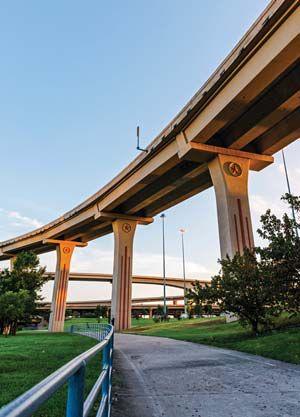
Ellum and the planned Loop, p. 34). In the opposite direction, trail users can follow the winding concrete path underneath Greenville Avenue to the Cottonwood Creek Trail, p. 29, which dips under the High Five interchange, extending to Richardson’s trail network. Plans to connect other trails, such as the Lake Highlands Trail to the White Rock Creek Trail, are underway. The stretch is popular with cyclists, due to the uninterrupted flow and commuter potential, though on certain parkside sections that are popular with preoccupied parents, toddlers and tiny tricyclists, caution is advised.
Cottonwood Creek Trail
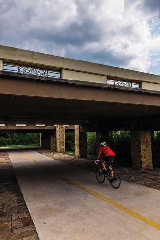
The Cottonwood Creek Trail connects our neighborhood to northern Dallas; our White Rock Creek Trail melds into it near the base of the I-635 interghange, whose reconstruction brought in financial assistance from the Texas Department of Transportation (TxDOT), along with Dallas County and the North Texas Council of Governments (NTCOG). The Cottonwood Trail includes an impressive section marked by long murals and blossoming foliage (and, at times, yes, graffiti) underneath the massive highway. City planners also hope to make connections between Cottonwood and southern Dallas via the planned
Loop (p. 34). Councilman Adam McGough says talks have been in the works for years about trying to connect the Richland College campus to Cottonwood. “It is part of the push for integrating neighborhood trails with major trails, which we want to support in the next bond package,” McGough says. Keep an eye on advocatemag.com for bond meeting dates, which will include opportunities for neighbor input.
WILL ALAMO DRAFTHOUSE BRING A NEW WHITE ROCK CREEK TRAIL ENTRANCE?
SHORTLY AFTER ALAMO DRAFTHOUSE announced the construction of a nine-screen movieplex at the former Tom Thumb space at Skillman and Abrams, property owners and developers presented renderings to our city’s Urban Design Peer Review panel depicting a conceived trail entrance at the north end of the shopping center. As it stands, a makeshift entrance to the White Rock Creek Trail, clandestine and made of gravel, exists there, across Abrams from Top Golf. The Park department’s Peter Bratt says the idea of increasing trail accessibility at the new development is exciting, though not without challenges. An official trail entrance, for one thing, would need to comply with the Americans with Disabilities Act, and the grade from Abrams to the trail is excessively steep. Then there is the matter of funding. Retail Plaza Inc.,
Flag Pole Hill Trail
Once Called Katy Trail
not Alamo, owns the center, and agreed to make improvements to accommodate the Alamo, though no commitment to trail improvement funding has been discussed. Also the project sits outside the Skillman Corridor Tax Increment Financing District and therefore cannot draw public funds for property upgrades unless those lines are redrawn, which can happen. There are ways to do that, says District 10 Councilman Adam McGough. “Make a proposal, just like anything else ... I can’t say until I’ve seen [a proposal] but I believe I would support it.”
The project, cheered by McGough, District 9’s representative Mark Clayton and residents of the surrounding Lake Highlands and East Dallas neighborhoods, is actually in Jennifer Staubach Gates’ City council District 13, which covers Vickery Meadow and Preston Hollow.
PHASE IV, the Flag Pole Hill Trail connects by way of the SoPac Trail to Ridgewood Trail (see p. 32) and the Katy Trail. In the other direction, it runs east along Northwest Highway past the Merriman Park/ University Manor neighborhood. In fact, that neighborhood helped come up with the new name, according to its newsletter. “Our desire was to have a name closely associated with White Rock Lake, since we consider our neighborhood as the gateway to White Rock.” The hike/bike trail will intersect the White Rock Creek and White Rock Lake trails and extend to the Dallas Police Department substation and the former Muchert Army Reserve Center, which will be the new Dallas Park and Recreation department headquarters come 2018; that property neighbors Flag Pole Hill.


