11 minute read
Natural Disasters in Asia
from GREEN TECHNOLOGY
Natural disasters are extreme, sudden events caused by environmental factors that kill or injure people and damage property. Earthquakes, floods, eruptions, and typhoons all strike anywhere on earth, often without warning. These are some of the biggest natural disasters that hit Asia in 2013.
Typhoon Haiyan
Advertisement
September 2013
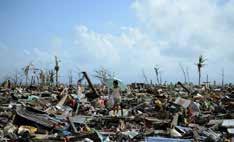
Super typhoon Haiyan made history in the Philippines as the deadliest natural disaster to ever hit the calamity-prone country with winds up to 190-195 mph, making it the fourth most intense tropical cyclone ever observed in the world. The typhoon, known in the Philippines as Yolanda was the strongest ever recorded, it surpassed the record of the previous deadliest Philippine storm, Thelma, in which about 5,100 people died in the central Philippines in 1991. It was late evening of 7 November when Haiyan sent storm surge and merciless winds rampaging Typhoon Usagi
September 2013
A powerful storm hit the Western Pacific and smashed into Hong Kong and Southern China after sweeping past the Philippines and Taiwan, leaving a trail of destruction in its wake. across a huge chunk of the archipelago. One survivor akin her experience to a scene in the movie Titanic on the morning of 8 November, “the winds were banging on every side of the house. It had this shrill and scary sound to it that gave us goose bumps. The water was coming in fast - too fast. It was already knee level and we knew that it would be deeper outside. But we couldn’t go outside, it was too dangerous. The winds were too strong and debris were flying around,” she painfully recalled.
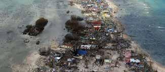

In the aftermath of Haiyan, the scale of destruction is so immense in Tacloban that the local Typhoon Usagi, characterized by meteorologists as the strongest storm in the world this year caused massive destruction that killed at least 33 people in Asia. It was classified as a severe typhoon with winds of 175 kilometers (109 miles) per hour and gusts of up to 213 kph (132 mph). In China, 25 people were reportedly killed in worst-hit city, Shanwei where winds blew cars off the road near a gas station and houses were toppled which led to the evacuation of thousands of people and widespread electricity outages. Philippine officials reported eight casualties from drowning and landslides while Taiwan authorities said nine people were hurt by falling trees. On 22 September, the super typhoon forced hundreds of flight cancellations and shut down shipping and train lines when it began pounding Hong Kong. Hundreds of arriving and departing flights were cancelled government was unable to respond fast. There were scenes of mayhem as starving survivors broke into shops, homes, and gasoline stations. Before and after photos of the hardest hit areas swamped the internet sending signals to the world that the Philippines badly needed help. On 11 November, Philippine President Benigno Aquino issued Presidential Proclamation declaring a state of national calamity. As of 12 December, the total number of casualties reached 5,982 and the total cost of damaged is roughly estimated to $810 million according to the National Disaster Risk Reduction and Management Council. United Nation’s experts estimate that it will take years to restore infrastructure and rebuild the community in Tacloban. Sources: The Philippine Inquirer, Agence France
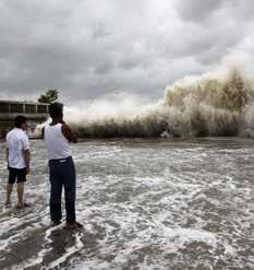
Presse, The Guardian in Hong Kong International Airport and Ferry services between Hong Kong and nearby Macau and outlying islands were also suspended as the observatory raised the warning to No. 8 storm signal, the third highest on a five-point scale.
On 21 September, the Philippine government raised its storm warning to its highest level since 2010, according to the Wall Street Journal; while China’s main meteorological service issued a “red alert” as Usagi veered towards southern China, particularly in Guangdong province, as well as neighboring Fujian province. The official Xinhua news agency reported that more than 44,000 fishing boats were asked to return to port in Guangdong while Fujian Province evacuated more than 80,000 people from flood-prone areas and deployed 50,000 disaster-relief workers.
In Taiwan, more than 3,300 people were evacuated from flood-prone areas and mountainous regions. The storm also caused a landslide that buried a rail line on Taiwan’s southeast coast.
Top Five Most Powerful Earthquakes in Asia in 2013
Date Location
24 September
15 October
20 April
22 July
2 July Balochistan, Pakistan Bohol Island, Philippines Lushan County, China Gansu, China Aceh Indonesia
Magnitude
7.7
Death Toll
825
Depth (km)
20
7.2 222 20
6.6
6.6
6.1 193
95
35 12
20
10
Bohol Earthquake
October 2013
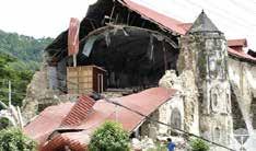
A magnitude-7.2 earthquake hit three of the most popular tourist destinations in the Philippines: Bohol, Cebu, and Siquijor, on 15 October, killing at least 200 people, displacing more than 10,000 families and severely damaging some of the country’s historic churches dating from the Spanish colonial period. The Philippines’ oldest church, the 16 th century Basilica of the Holy Child in Cebu lost its bell tower. A 17th-century limestone church in Loboc town, crumbled to pieces, with nearly half of it reduced to rubble. Two other churches in Maribojoc and Loon were destroyed while churches in Loay, Clarin, and Baclayon as well as the belfry in Panglao were also damaged. There were 134 reported deaths in Bohol province, while at least 15 died in nearby Cebu and one in Siquijor. The number of injured rose towards 300, with at least 23 people still missing. In Cebu City, a number of people died when two buildings and a fish port crumbled, as did the roof of a mall under construction. Five people were crushed to death and eight were injured after a stampede caused by a crowd rushing to evacuate a gym in Cebu. At least 250 patients of Cebu City Medical Center (CCMC) were evacuated after cracks were found in the hospital. Most of the patients were relocated to the nearby gym while others stayed under the tents placed on the sidewalk near CCMC. Photos and videos flooded the social media showing extensive damage to old churches, roads and bridges, modern buildings, and schools, and the very famous Chocolate Hills in Bohol. The news about the quake spread quickly over Twitter and Facebook as office and schools were closed the day of the quake as it was a national holiday, Muslim festival of Eid al-Adha, in the Philippines. On 16 October, Cebu declared a state of calamity and suspended classes in both private and public schools to allow school officials to inspect the buildings. The Philippine Institute of Volcanology and Seismology (Phivolcs ) recorded 1,300 aftershocks, 28 of which were felt and the strongest of which was magnitude 4.3. According to Phil volcs , the movement of the East Bohol Fault triggered the strongest quake in the Visayas in 23 years. The U.S. Geological Survey initially reported the quake as having a magnitude of 7.2, but shortly afterward lowered it to 7.1.
Sources: Huffington Post, Reuters, Daily Mail, BBC News, and The Guardian
7.7-magnitude Earthquake in Pakistan
September 2013
A powerful 7.7-magnitude earthquake struck north-east of Awaran in Pakistan and killed at least 328 people, wounding hundreds more in Pakistan’s remote south-west province of Balochistan.
The disaster hard-hit the remote province, a conflict zone where separatists and government troops have been fighting for years. Many houses were flattened and thousands of people spent the night in the open. Most of the victims were killed when their houses collapsed. Walls of the mud brick houses were destroyed and people gathered outside because they had no homes to sleep in.
Balochistan is Pakistan’s largest province in terms of land area but also the least populated and most impoverished. Relief and rescue operations encountered difficulty reaching the distant villages due to poor infrastructures and bad road conditions.

After the quake, a mountain-like island (pictured above) appeared off the coast near the port of Gwadar. Experts say the island was formed when the massive quake shook a deposit of natural gas trapped below the surface. The small island appeared 600 metres off Pakistan’s Gwadar coastline in the Arabian Sea.
Sources: ABC News, Daily Mail, Fox News, and BBC News
Killer Earthquakes in China
April 2013
In April 2013, a powerful earthquake struck China’s south-western Sichuan province leaving at least 190 people dead and more than 2,600 injured, nearly five years after a devastating quake caused widespread damage across the region.
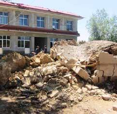
The earthquake toppled buildings, prompted landslides, and caused phone and power outages in the mountainous Lushan county, the worst-hit area, which is prone to earthquakes as it is situated where Sichuan plain meets foothills leading to the Tibetan plateau, and sits atop the Longmenshan fault.
The 6.6-magnitude shock is believed to have been on the same fault as the 2008 killer earthquake with 7.9 magnitude that left 70,000 dead and another 18,000 missing in the province.
In July, another magnitude 6.6 earthquake jolted another mountain region in south-west China with at least 90 people reported dead and 887 were injured. The epicenter was calculated to be 34.5 north and 104.2 east, which is about 15 km from the Minxian County, 45 km from the Zhangxian County, 120 km from the Dingxi City and 170 km from Lanzhou, Gansu’s provincial capital.
According to official reports, about 123,000 houses collapsed or severely damaged, while 138,000 houses were damaged to varying degrees, leading to direct economic loss of 3.94 billion RMB.
Volcanic Eruptions in Indonesia
September 2013
Two of the most active volcanoes in Indonesia erupted in August and September, displacing thousands of people from their villages and killing six people.
In September, Mount Sinabung, the highest mountain in North Sumatra with an altitude of about 2,600 meters spewed thick ashes into the sky after being dormant in three years. More than 6,200 were evacuated and five people were hospitalized due to breathing difficulties after inhaling volcanic ashes.
Mount Sinabung, located in western Indonesia, last erupted in August 2010 killing two people and forcing 30,000 others to flee. It caught many scientists off guard after failing to monitor the volcano, which had remained quiet for four centuries.
In August, another active volcano Mount Rokatenda in East Nusa Tenggara province erupted, sending smokes of hot ash nearly 2,000 meters into the air and killing five people as torrents of molten lava poured down the volcano’s slopes.
Mount Rokatenda is one of the 129 active volcanoes in Indonesia, an archipelago of more than 17,000 islands that is home to 240 million people. It has been on high alert since October 2012 as it has been showing signs of increased volcanic activity since last year. Authorities banned people from any activity within three kilometers from the crater but some villagers refused to leave including the five people engulfed by the volcanic emission.
The country’s most active volcano Mount Merapi in central Java, killed more than 350 people in a series of violent eruptions in 2010.
Indonesia, the world’s largest archipelago nation, is prone to earthquake and seismic tremors as it sits along the Pacific “Ring of Fire.” The so-called “Ring of Fire” is a horseshoe-shaped area of fault lines stretching from the Western Hemisphere through Japan and Southeast Asia where a large number of earthquakes and volcanic eruptions occur in the basin of the Pacific Ocean.
North India floods: Worst Natural Disaster since 2004 Tsunami
June 2013

In June 2013, the Northern India state of Uttarakhand experienced the worst floods and landslides in the country since the great Indian Ocean tsunami in 2004.
At least 5,700 people were “presumed dead” with more than 4,000 missing and 110,000 people displaced when the deadly flood ravaged northern India and neighboring Nepal after experiencing heavy rainfall from 14 to 17 June 2013. The downpour triggered the melting of Chorabari Glacier, with a height of 3800 metres, and the outburst of the Mandakini River.
Hundreds of roads and bridges were destroyed that left about 100,000 pilgrims and tourists trapped in the valleys leading to three of the four Hindu Chota Char Dham pilgrimage sites. This also made the job of rescue workers all the more difficult.
Sources: The Hindustan Times, The Economic Times

In the latest update from The Economic Times, the maximum number of people reported missing are from Uttar Pradesh (1,150), followed by Uttarakhand (852), Madhya Pradesh (542), Rajasthan (511), Delhi (216), Maharashtra (163) , Gujarat (129), Haryana (112), Nepal (92), Andhra Pradesh (86), Bihar (58), Jharkhand (40), West Bengal (36), Punjab (33) Chhattisgarh (29), Orissa (26), Tamil Nadu (14), Karnataka (14), Meghalaya (6), Chandigarh (4) Jammu and Kashmir (3), Kerala (2), Puducherry (1) and Assam (1). The list was verified in consultation with top authorities in India and Nepal.
Uttarakhand, known for its natural beauty of the Himalayas, borders the Tibet Autonomous Region on the north; the Mahakali Zone of the Far-Western Region, Nepal on the east; and the Indian states of Uttar Pradesh to the south and Himachal Pradesh to the northwest.


