
3 minute read
LET’S DISCOVER AJARA! ROUTES


If have already packed your backpack and are ready to explore the mountains of Ajara, we will help you choose and plan the right route. Our region has a lot of interesting destinations one can marvel over : adventure routes, including in the alpine zone, as well as cultural, historical, culinary or wine routes. All these are accompanied by incredibly picturesque landscapes making your camera working hard throughout your whole journey.
Advertisement
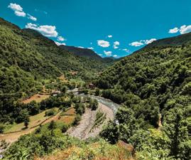
MILISI VILLAGE - MILISI MOUNTAIN - MACHAKHELA NATIONAL PARK - ACHARISAGMARTI VILLAGE
Route type: linear
Route type: walking, car, cycling
Difficulty level: easy
Total: 14.2 km
Maximum height above sea level: 938 m
Duration: 5-6 hours
Cellular coverage area: full
Recommended route: April - October.
The route starts from the village of Milisi and follows a dirt road. It can be completed either by car, preferably 4WD, or on foot. After you reach the border of Machakhela National Park, then you can walk or drive by car through Uchkhiti to Machakhela Gorge.
The distance from the village of Milisi to Mount Milisi is 4 kilometers. This distance is best covered with an all-wheel drive vehicle. Further, you need to walk a 5-kilometer path from Mount Milisi to Mount Archangel (Machakhela National Park). Here the route crosses the walking trail of Machakhela National Park and continues southeast of the crossing point along a dirt road. After 1 kilometer, a concrete road begins, and after another 4 kilometers the road leads to the Visitors’ Center of Machakhela National Park.
The route continues from the Visitors’ Center of Machakhela National Park. To the north, there is a concrete road to the village of Acharisagmarti. After 4 kilometers, the trail turns into unpaved road again. This is where you need an SUV. After 1 km you will come to a road junction. To the west of it, the mountain trail of the Archangel continues. After 2 kilometers, you will meet another crossroads, from where the road leads to the village of Uchkhiti in the northern direction. But our route goes east to the village of Milisi, 4 km from the specified intersection of roads.
The total length of the route is 45 km
The length of the car road section is 11 km
The length of the pedestrian section is 34 km
Difficulty of the route: medium
Route type: pedestrian, car (4x4)
Duration of the route: three days, two nights
Maximum height above sea level: 2518 m
Cellular coverage area: partial
Season: May-September
It is better to go with an experienced guide. The walk along the wilderness trail will take 2-3 days and requires good physical fitness, use of GPS, orientation in the terrain, as well as the ability to read maps of the area. For spending the night, you will need a tent, which you need to take with you along with other necessary things. We start the route from the village of Akho, which is located 50 km from Batumi, in the municipality of Keda. In the village of Akho, you can visit a monument of national importance - the Akhos Jame (mosque), built on the ruins of a Christian church.
At the beginning of the village of Khinotsminda, there used to be the Church of St. John the Baptist, which by its construction technology dates back to the 8th-9th centuries. According to historical data, only the altar has survived, which in 1919 it was completely destroyed. During the route, travelers will spend the night in Khinotsminda, in the local guest houses or in tents.
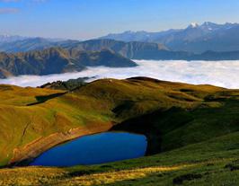
5.8 km from Khinotsminda, in the vicinity of Mount Sarbiela, there is a crossroads, from where a 4.4 km hiking trail leads to the north to Lake Tbikeli, and a 9-km trail to Jvarimindori to the east. The trail from Khinotsminda to Lake Tbikeli is marked, its length is 10 km.
Lake Tbikeli, located between the mountains, fascinates at first glance with its oval shape and mirror surface. Around it you will find a very clean meadow and unspoiled nature.
The distance from the village of Akho to the beginning of the walking route is 11 km. This section of the route can be driven by an off-road vehicle. After passing 6.6 km to the north, the route enters the village of Khino. Only one family lives in this village, there is a monastery and the ruins of an old church. According to legend, the name “Khino” is associated with Queen Tamar. Once this village was visited by Queen Tamara and a big feast was held in her honor. Hence the name of the village “Khino” (Lkhini, Lkhena - feast / feast) originated.
The 4-kilometer section of the trail from Khino to Khinotsminda passes through the forest along a dirt road. If you accidentally bump into a vehicle while traveling on the road, you can take it and save your time.
Lake Tbikeli is located at an altitude of 2200 meters above sea level. If you look closely at the clear water, you will easily notice the Caucasian newts in it, listed in the Red Book of Georgia.
You can spend your second night in tents near Lake Tbikeli. It is important to know that there is no telephone connection or the Internet and you cannot contact anyone from here if necessary. In addition, the lake is foggy in the evenings and windy at night. Considering all of the above, it is better to return and spend the night in tents at the already marked place (in Khinotsminda).
Jvarimindori is a spacious alpine meadow, often covered with fog, with wooden cabins. A traveler who has come here from afar can relax in these houses and eat fresh local products.