As good stewards of the land and forest, Sustainable Forestry Initiative (SFI) certified organizations believe forest landowners share an important stewardship responsibility and commitment to society. They recognize the importance of maintaining working forests. They support sustainable forestry on forestland they manage and promote sustainable forestry on other lands. They support efforts to safeguard private property rights and help private landowners manage forestland sustainably.
Certified SFI companies commit to SFI Standards and a forest management concept that ensures sustaining Alabama’s forests from one generation to another. Based on guiding principles, SFI Standards promote sustainable forestry. Standards focus on maintaining or advancing biological diversity at the stand and landscape level across a diversity of forest and vegetation cover types and successional stages including the conservation of forest
Rank Definition
plants and animals, aquatic species, threatened and endangered species, Forests with Exceptional Conservation Value, old-growth forests, and ecologically important sites SFI Standards address threats to healthy forests. Threats may include invasive species and land conversion. Certified organizations take special caution to protect long-term forest health and conserve biological diversity.
NatureServe, an organization that works with over 60 governmental and non-governmental programs in North America, collects, analyzes, and delivers biodiversity knowledge that informs conservation action. NatureServe developed a range-wide conservation status ranking system for all species. Using the NatureServe ranking system along with species information from the Alabama Natural Heritage Program, a list of imperiled ecological communities was developed.
GX Presumed Extinct (species) Not located despite intensive searches and virtually no likelihood of rediscovery. Presumed Eliminated (ecosystems, i.e., ecological communities and systems) Eliminated throughout its range, due to loss of key dominant and characteristic taxa and/or elimination of the sites and ecological processes on which the type depends.
GH Possibly Extinct (species) or Possibly Eliminated (ecosystems) Known from only historical occurrences but still some hope of rediscovery. Examples of evidence include (1) that a species has not been documented in approximately 20–40 years despite some searching and/or some evidence of significant habitat loss or degradation; (2) that a species or ecosystem has been searched for unsuccessfully, but not thoroughly enough to presume that it is extinct or eliminated throughout its range.
G1 Critically Imperiled At very high risk of extinction or elimination due to very restricted range, very few populations or occurrences, very steep declines, very severe threats, or other factors.
G2 Imperiled At high risk of extinction or elimination due to restricted range, few populations or occurrences, steep declines, severe threats, or other factors.
G3 Vulnerable At moderate risk of extinction or elimination due to a fairly restricted range, relatively few populations or occurrences, recent and widespread declines, threats, or other factors.
G4 Apparently Secure At fairly low risk of extinction or elimination due to an extensive range and/or many populations or occurrences, but with possible cause for some concern as a result of local recent declines, threats, or other factors.
G5 Secure At very low risk of extinction or elimination due to a very extensive range, abundant populations or occurrences, and little to no concern from declines or threats.
Under the Endangered Species Act (ESA), plant and animal species may be listed as either endangered or threatened. Endangered means a species is in danger of extinction throughout all or a significant portion of its range. Threatened means a species is likely to become endangered within the foreseeable future.
The following ecological communities are categorized as G1 or G2 by NatureServe. SFI certified organizations recognize management considerations for these ecological communities. Information about the physiographic region, common plants, soil type, wildlife, and management considerations is available in the fact sheets
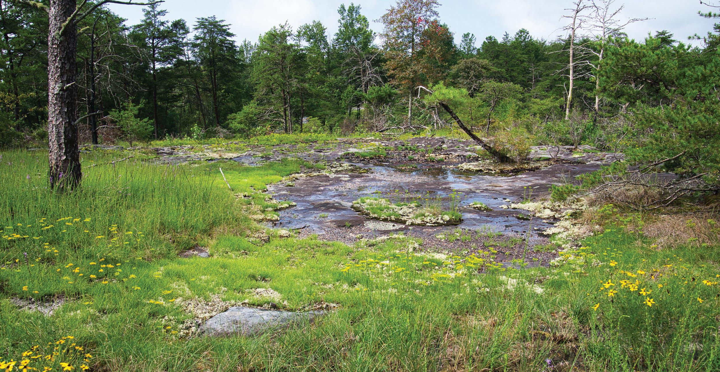
Alabama Cumberland Sandstone Glade
G2/S2 Natural Community
This community type consists of scattered vegetated rock outcrops, perennial grasslands and woodlands that occur on shallow soils that occur on Lookout Mountain and Sand Mountain in northeastern Alabama. They vary in size from less than 1 acre to as large as 4 to 5 acres (NatureServe Explorer 2024).
Soil Information
This community type occurs on a thin layer of fine sandy loam with a thicker layer of loam or clay loam underlain by weathered bedrock. The soils are well-drained and generally non-hydric (NatureServe Explorer 2024).
Counties of occurrence
Blount County
Cherokee County
Dekalb County
Etowah County
Jackson County
Jefferson County
Lawrence County
Marshall County
Commonly Found Plants
Common Community Name: Nuttall’s Rayless-goldenrod - Woodland Tickseed - Small-head Blazingstar Grassland
Herbs & Grasses - This is the most dominant group, with the following characteristic species:
Regional Endemics & Rare Species - There are many regional endemics and otherwise rare species in this type of community, including:
• Little River Canyon Onion (Allium speculae), Woodland Tickseed (Coreopsis pulchra), Harper’s Dodder (Cuscuta harperi), Mountain Bush-Honeysuckle (Diervilla rivularis), Longleaf Sunflower (Helianthus longifolius), Boynton Sand Post Oak (Quercus boyntonii), Texas sunnybell (Schoenolirion wrightii), and Menges’ Flameflower (Phemeranthus mengesii).
Trees & Shrubs - There is typically, a scattering of small trees and shrubs, including:
• Virginia Pine (Pinus virginiana), Red Maple (Acer rubrum), White Fringetree (Chionanthus virginicus), Mountain Laurel (Kalmia latifolia), Farkleberry (Vaccinium arboreum), and various Oaks (Quercus spp).
Photo Credit: Kelly Homan
Photo Credit: Kelly Homan
Woodland Tickseed (Coreopsis pulchra)
Photo Credit: Kelly Anderson and Mason Brock
Wildlife
These glades are generally small enough that any animal present in the surrounding habitat may utilize them in their daily travels. Snakes and lizards are known to utilize sandstone glades for several purposes, but the rocky outcrops provide ideal locations to “sun” and thermoregulate. Pollinators such as butterflies, moths, and bees utilize areas with established perennial grasses and herbaceous plants. Insect life may be unique in glade environments and often have adaptations to allow survival in xeric conditions. Small mammalian predators may visit these glades in search of prey items such as insects and rodents.
Management Considerations
These unique areas typically do not contain tree species desired by markets. Consider limited traffic in area as soils are very thin and susceptible to damage. Use prescribed burning to maintain and enhance the native grass and herbaceous communities and help control invasive species and encroachment. Consider buffering when herbicide application or harvest operations are planned on adjacent stands. Excessive water flow through the area can expedite soil erosion and disturbance. Follow guidelines in Alabama’s Best Management Practices for Forestry
Physiographic regions:
Southwestern Appalachians
• Southern Table Plateaus
• Plateau Escarpment
• Dissected Plateau
Valley
• Southern Sandstone Ridges
Bluestem (Schizachyrium scoparium)
Vegetation Zones
In this type of community, there are four fairly distinct zones of vegetation. In the photos to the left, you can see that there are plants and lichens growing on and around the rocks, with herbaceous plants growing in patches, and shrubs and trees surrounding the glade. The four basic zones are:
(1) The Lithophytic Zone
The term lithophyte means “a plant that grows on bare rock or stone”. Therefore, this zone describes the vegetation that grows on the bare rocks. This includes crustose, fruticose, and foliose lichens, as well as mosses.
(2) The Herbaceous Zone
This zone describes the hebaceous vegetation growing among the rocks, such as Nuttall’s Rayless Goldenrod, Tickseed, and Little Bluestem.
(3) The Shrub Zone
This zone describes the shrubby vegetation growing among the rocks and near the tree zone, such as Farkleberry and Mountain Laurel.
(4) The Tree Zone
Finally, trees surround the glade with some growing in pockets of soil within the glade. The most dominant tree in this community is the Virginia Pine.
Nuttall’s Rayless Goldenrod (Bigelowia nuttallii)
Photo Credit: Joel McNeal
Little
Photo Credit: Kelly Homan
Photo Credit: Kelly Homan
Photo Credit: Kelly Homan Ridge and
Appalachian Low-Elevation
Granitic Dome
Soil Information
The well-drained soil of this community is sandy loam underlain by bedrock (NatureServe Explorer 2024).
Commonly Found Plants
Counties of occurrence:
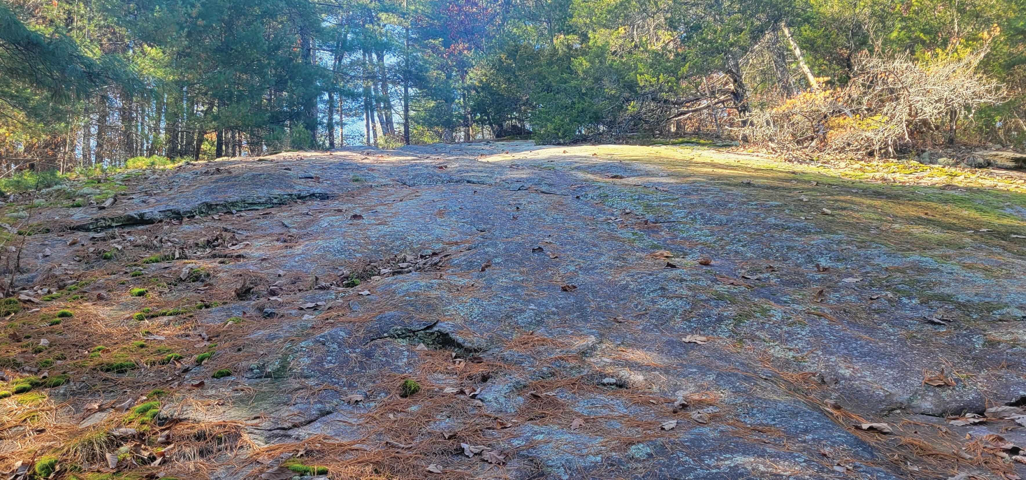
G2/S1 Natural Community
This community type occurs in areas where the substrate (surface material) has few places for soil accumulation, and most of the areal extent is bare rock. This association typically occurs at elevations lower than 3000 feet and can occur in large patches, ranging in size from a few acres to over 100 acres (NatureServe Explorer 2024).
This community type is known to occur in Alabama, Georgia, and North Carolina.
Common Community Name: Rock Spikemoss - Little BluestemOrange-grass - Dense-tuft Hairsedge Rocky Grassland
Vegetation consists primarily of lichens on bare rock or of shallow mats generally dominated by Rock Spikemoss (Selaginella rupestris) occurring with other distinctive species.
Woody vegetation - Woody species from adjacent woodlands and shrublands may be scattered, rooted in deeper soil pockets, older stable vegetation mats, and in marginal zones between the exposed rock and adjacent forests (NatureServe Explorer 2024). Typical species include:
• Sand Hickory (Carya pallida), White Fringetree (Chionanthus virginicus), White Ash (Fraxinus americana), Eastern Red Cedar (Juniperus virginiana), Mountain Laurel (Kalmia latifolia), Shortleaf Pine (Pinus echinata), Pitch Pine (Pinus rigida), Chestnut Oak (Quercus montana), Carolina Azalea (Rhododendron minus), Winged Elm (Ulmus alata), and Florida Deerberry (Vaccinium stamineum).
Herbaceous vegetation - Herbaceous species occur in soil areas, including:
Species native to the area will travel through this community type as part of their daily activities. Snakes and lizards are known to utilize these unique areas, especially for sunning and thermoregulation. Small mammals may utilize the pockets of areas with some soils, native grasses and herbaceous plants. Pollinators such as butterflies, moths, and bees utilize areas with established perennial grasses and herbaceous plants. Insects present may have adaptations that enhance survival in highly xeric conditions.
Management Considerations
These unique areas typically do not contain tree species desired by markets. Consider limited traffic in area as soils are very thin and susceptible to damage. Consider buffering when herbicide application or harvest operations are planned on adjacent stands. Excessive water flow through the area can expedite soil erosion and disturbance. Follow guidelines in Alabama’s Best Management Practices for Forestry.
Photo Credit: NPS
Photo Credit: Jessie Hudson
Black Belt Prairies
Soil Information
In Alabama, the soil formations of these prairie systems primarily consist of chalk or loose clay on top of chalky soils (Demopolis and Mooreville Chalk). There is very little fertile top soil which makes these areas highly susceptible to erosion (NatureServe Explorer 2024).
Rose Pink (Sabatia angularis) at
Counties of occurrence:
Autauga
Bullock
Butler
Crenshaw
Dallas
Greene
Hale
Lowndes
Macon
Marengo
Montgomery
Crenshaw
Perry
Pickens
Russell
Sumter
Wilcox
G1/S1 Natural Community
This natural community type occurs across an area known as the “Black Belt” of Alabama and Mississippi. The Black Belt is a crescent shaped region characterized by weathered rolling plains. These prairies contain an abundance of unique native grasses and herbs providing necessary habitat for birds, pollinators, and other wildlife such as snakes and small mammals (NatureServe Explorer 2024).
Common Community Name:
Little Bluestem - Indiangrass - White Prairie-clover - Scaly Blazingstar - (Prairie Rosinweed) Black Belt Grassland
Commonly Found Plants
Grasses - most dominant group, with the following characteristic species:
• Bushy Bluestem (Andropogon glomeratus), Broomsedge (Andropogon virginicus), Side Oats Grama (Bouteloua curtipendula), Little Bluestem (Schizachyrium scoparium), and Switchgrass (Panicum virgatum)
Herbs - second-most dominant group, with the following characteristic species:
• Prairie Indian Plantain (Arnoglossum plantagineum), Bushy Asters (Aster dumosus), Clasping Aster (Aster patens), Downy Wood Mint (Blephilia ciliata), American Bluehearts (Buchnera americana), Partridge Pea (Chamaecrista fasciculata), Arrowhead Rattlebox (Crotalaria sagittalis), White Prairie Clover (Dalea candida), Purple Prairie Clover (Dalea purpurea), Illinois Bundleflower (Desmanthus illinoensis), Hairy Small Leaf Ticktrefoil (Desmodium ciliare), Clasping Coneflower (Dracopis amplexicaulis), Slender Bushclover (Lespedeza virginica), Tall Blazingstar (Liatris aspera), Scaly Blazingstar (Liatris squarrosa), Yellow Puff (Neptunia lutea), Crowpoison (Nothoscordum bivalve), Prairie Coneflower (Ratibida pinnata), Wild Petunia (Ruellia humilis), Rose Pink (Sabatia angularis), Prairie Dock (Silphium terebinthinaceum), Whorled Rosinweed (Silphium trifoliatum var. latifolium), Blue-eyed Grass (Sisyrinchium albidum), and Gray Goldenrod (Solidago nemoralis), and others
Trees & Shrubs - Trees and shrubs may occur in small patches within the prairies, and at the edges. The following species are characteristic:
• Chinquapin Oak (Quercus muehlenbergii), White Ash (Fraxinus americana), Eastern Redbud (Cercis canadensis), Eastern Red Cedar (Juniperus virginiana var. virginiana), Carolina Buckthorn (Frangula caroliniana), Gum Bumelia (Sideroxylon lanuginosum), Hawthorn (Crataegus spp.), and Roughleaf Dogwood (Cornus drummondii)
Old Cahawba Prairie Tract
Prairie Coneflower (Ratibida pinnata)Coneflowers are a common herb/forb in Black Belt Prairies.
Wildlife
Black Belt prairies host numerous invertebrates and are important habitats for pollinators. These plant communities also support upland game species such as rabbits and bobwhite quail. Many songbird species also rely on prairie and other early successional grasslands.
Management Considerations
These unique areas typically do not contain tree species desired by markets, consider avoiding during harvests. Prescribed burning can be used to maintain and enhance the native grass and herbaceous communities and help control invasive species. Consider buffering prairies when herbicide application is planned on adjacent stands. Follow guidelines in Alabama’s Best Management Practices for Forestry.
Physiographic regions:
Southeastern Plains
• Blackland Prairie
• Flatwoods/Blackland Prairie Margins
• Southern Hilly Gulf Coastal Plain
• Northern Hilly Gulf Coastal Plain
Scaly Blazingstar (Liatris squarrosa)This and other species of Blazingstar are common in Black Belt Prairies.
Cahaba
Little Bluestem (Schizachyrium scoparium) - This and other grasses are dominant in Black Belt Prairies.
River Prairies
Many of the Cahaba River Prairies are high quality. These prairies have been minimally affected by invasive species, have low levels of erosion, and are fairly large in size. Grasses, such as Indian Grass, Little Bluestem, and Sideoats Grama are prominent species.
This region contains one of the highest concentrations of Black Belt prairies remaining in Alabama, and was the second-largest prairie complex identified in the state during 2008 surveys. These prairies are some of the highest quality prairies in Alabama.
Old
Cahawba Prairie Complex
These prairies around the historic ghost town of Old Cahawba are diverse, due to the land use practices of the early 1800s. The main area of this site is now the Forever Wild Old Cahawba Prairie Tract. These prairies represent a wide range of quality.
Braggs – Ridgeville Prairie Complex
Cahaba Riverwash Prairie
G1/S1 Natural Community
This natural community type occurs in central Alabama along the Cahaba River. Flash flooding occurring along the shoreline maintains this community. The flooding keeps woody vegetation stunted and gives it a twisted apearance. Grasses and herbaceous plants dominate this community (NatureServe Explorer 2024).
Soil Information
Typically exposed, the soil in this type of natural community is comprised of sandstone, siltstone, and shale appearing as a mixture of cobble and sandy silt (NatureServe Explorer 2024).
Commonly Found Plants
Counties of occurrence:
Bibb County, Alabama
Physiographic region:
Common Community Name: (Willow species) / Big BluestemSwitchgrass - Azure Blue Sage Cahaba Riverscour Wet Meadow
Grasses - approximately 40% of the community. Primarily composed of 3 species:
• Big Bluestem (Andropogon gerardii), Little Bluestem (Schizachyrium scoparium), and Switchgrass (Panicum virgatum)
Herbs - second-most dominant group, with the following characteristic species:
Trees & Shrubs - the following species are characteristic:
• Black Willow (Salix nigra), Carolina Willow (Salix caroliniana), Maidenbush (Phyllanthopsis phyllanthoides), River Birch (Betula nigra), Green Ash (Fraxinus pennsylvanica), and Buttonbush (Cephalanthus occidentalis)
Wildlife
Many species utilize the riverbank for travel and obtaining water. Insect and pollinator abundance may increase with native grass presence. Seasonal moisture levels may influence amphibian presence and abundance.
Management Considerations
Located along the shoreline of the Cahaba River, these areas typically do not contain tree species desired by markets. Woody species are often twisted and contorted as a result of abrasive actions associated with flooding. Consider designating these areas as Streamside Management Zones (SMZ) following guidelines in Alabama’s Best Management Practices for Forestry
Ridge and ValleySouthern Sandstone Ridges
Photo Credit: Al Schotz
Photo Credit: Kim Gothard
Coastal Plain Limesink Pond (Threadleaf Beaksedge
Type)
G2/S1 Natural Community
Limesink ponds developed where limestone deposits dissolved over time. Lower margins or areas of sinkholes and depression areas form specific plant community types. They are found in Atlantic and Gulf coastal plains from North Carolina, south to Florida, and west to Alabama. Limesink pond lower margin areas flood seasonally, covered in water more often than other areas (NatureServe Explorer 2024).
Soil Information
Soils of this community are loam and loamy sand that range from poorly drained to well-drained with some being hydric (wet). Slopes can range from about 0-5% (NatureServe Explorer 2024).
Counties of occurrence:
Covington County
Escambia County
Physiographic regions:
Southeastern PlainsSouthern pine plains and hills
Commonly Found Plants
Common Community Name:
Threadleaf Beaksedge - Annual Rush Marsh
Stands are dominated by Threadleaf Beaksedge (Rhynchospora filifolia) and Annual Rush (Juncus abortivus). Other characteristic species include other beaksedges and rushes, including Coastal Beaksedge (Rhynchospora pleiantha), Three-ribbed Spikerush (Eleocharis tricostata), Centella erecta, Short-beaked beaksedge (Rhynchospora nitens), and Lesser Creeping Rush (Juncus repens).
Some occurrences may be a mosaic of rosette and panic grass (Dichanthelium spp.)-dominated and beaksedge (Rhynchospora spp.)-dominated zones. In some other examples, the zones may be more distinctive and spatially separated.
Wildlife
Frogs and salamanders occur in these communities as they rely on fishless ponds for successful reproduction. As the ponds in this community type are only flooded seasonally, they offer excellent habitat for amphibians.
Management Considerations
These unique areas typically do not contain tree species desired by markets. Consider limited traffic in this habitat type. Use prescribed burning to maintain and enhance the native grass and herbaceous communities and help control invasive species and encroachment. Consider buffering when herbicide application or harvest operations are planned on adjacent stands. Follow guidelines in Alabama’s Best Management Practices for Forestry.
Photo Credit: Janet Wright
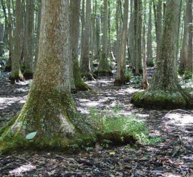
Cumberland Plateau Mesic Hemlock -Hardwood
Forest
G1G2/S1S2
Natural Community
These closed-canopy forests occur in steep mesic (moist) ravines associated with thick to massive bedded sandstone rock formations. This community type is only known to occur in Alabama. Most known examples of this community type are located in national forests, wildlife refuges, or other protected areas. This community may be found adjacent to stream corridors (NatureServe Explorer 2024).
Soil Information
This community occurs on sandy loam soils underlain by sandstone. Soils are non-hydric, meaning they are not typically saturated with water.
Trees - canopy - This community type has a closed canopy with the following species:
• Eastern Hemlock (Tsuga canadensis) and American Beech (Fagus grandifolia) usually codominate, with several associated species including Bigleaf Magnolia (Magnolia macrophylla), Pignut Hickory (Carya glabra), American Holly (Ilex opaca), American Hornbeam (Carpinus caroliniana), American Hophornbeam (Ostrya virginiana), Sourwood (Oxydendrum arboreum), Tulip Tree (Liriodendron tulipifera), and Sweet Birch (Betula lenta).
Trees - understory - common understory tree species include:
Herbaceous vegetation - hebaceous coverage is sparse with the following species:
• Boott ’s Sedge (Carex picta), Marginal Wood Fern (Dryopteris marginalis), New York Fern (Thelypteris noveboracensis), Christmas Fern (Polystichum acrostichoides), Lady Fern (Athyrium filix-femina), Downy Rattlesnake Plantain (Goodyera pubescens), Partridgeberry (Mitchella repens), Spotted Wintergreen (Chimaphila maculata), Canadian Wild Ginger (Asarum canadense), and Bloodroot (Sanguinaria canadensis).
Wildlife
Green salamanders, a species of high conservation concern, can be found in some examples of this habitat type as they utilize the moist sandstone outcrops extensively.
Management Considerations
The insect hemlock woolly adelgid (Adelges tsugae) is a threat to the dominant tree species in this community. Mesic conditions typically limit the application of prescribed fire, but it can be utilized to maintain and enhance the native herbaceous communities and help control invasive species if the leaf litter and weather conditions are favorable. Consider buffering area if herbicide applications or harvest operations are planned on adjacent stands. Follow guidelines in Alabama’s Best Management Practices for Forestry
Photo Credit: Dusty Hutchens
Photo Credit: Taylor Graham
East Gulf Coastal Plain Muck Bog
G1/S1 Natural Community
Soil Information
This community occurs on level terrain associated with wet, muck soils along streams. These muck soils are usually peat (partly decomposed vegetation) deposits that have undergone considerable oxidation and decomposition.
Counties of occurrence:
Baldwin County Washington County
Physiographic region:
Southeastern PlainsSouthern Pine Plains and Hills
This natural community type occurs only in deep peat and muck bogs in the East Gulf Coastal Plain of southern Alabama and Mississippi. Dominated with grasses and other herbaceous plants, these areas provide important habitat for birds, pollinators, and other wildlife. An excellent example in Alabama is Splinter Hill Bog Preserve in Baldwin County (NatureServe Explorer 2024).
Common Community Name:
Large Beaksedge - Coastal Plain Beaksedge - Gulf Bog Panicgrass - Chapman’s Yellow-eyed-grass - Coastal Sedge Seepage Meadow
Woody Vegetation - small islands of woody species can occur:
• Southern Bayberry (Morella caroliniensis) and Laurel Greenbrier (Smilax laurifolia)
Wildlife
Various amphibians (frogs and salamanders) find these communities attractive due to soils being mostly saturated throughout the year.
Management Considerations
These unique areas consist of wet, mucky soils which typically do not contain tree species desired by markets. Consider limiting traffic to established trails/roads. It is important not to modify the hydrological functionality of the site. Consider buffering bogs if herbicide applications or harvest operations are planned on adjacent stands. Follow guidelines in Alabama’s Best Management Practces for Forestry
East Gulf Coastal Plain Seepage Bog (Upper
Terrace Type)
G2/S2 Natural Community
This community type occurs in the Florida Panhandle and South Alabama in hilly landscapes typically associated with seepage on slopes where clay is close to the surface. Part of the Longleaf Pine Ecosystem, these areas are fire dependent and contain an abundance of native grasses providing important habitat for birds, pollinators, and wildlife (NatureServe Explorer 2024).
Soil Information
The region in which this community type occurs contains multiple soil types ranging from clay, to fine, coarse, and gravelly sand (NatureServe Explorer 2024).
Commonly Found plants
Counties of occurrence:
Baldwin Covington Escambia
Geneva Mobile Washington
Physiographic region:
Southeastern Plains-
• Southern pine plains and hills
• Dougherty Plain
Common Community Name: Beyrich’s Three-awn - Feather-bristle Beaksedge - Gulf Bog Panicgrass - (Thistleleaf Aster) Seepage Meadow
Vegetation in these communities is composed almost exclusively of herbaceous species.
These areas provide important habitat for birds, pollinators, and other wildlife such as the Eastern Indigo Snake, which occurs in well-maintained longleaf ecosystems.
Management Considerations
These unique areas typically do not contain tree species desired by markets. Consider limited traffic in the area. Use prescribed fire to maintain and enhance the native herbaceous communities and help control invasive species. Consider buffering bogs if herbicide applications or harvest operations are planned on adjacent stands. It is very important not to modify the hydrological functionality of the site. Follow guidelines in Alabama’s Best Management Practices for Forestry.
Photo Credit: Joshua Wimberly
Photo Credit: M. Brown
East Gulf Coastal Plain Wet Prairie
G2/S2 Natural Community
This community type occurs in a pine flatwoods landscape on very gently sloping to almost level topography and often has a scattered canopy of trees. This fire-dependent community is part of the Longleaf Pine Ecosystem. This community type is known to occur in the Florida Panhandle, South Alabama, and Southern Mississippi (NatureServe Explorer 2024).
Soil Information
The soils of this community type include variable sediments, ranging from clay to fine, coarse, and gravelly sand (NatureServe Explorer 2024).
Commonly Found Plants
Counties of occurrence:
Baldwin County
Physiographic regions:
Southeastern PlainsSouthern Pine Plains & Hills
Southern Coastal Plain - Gulf Coast Flatwoods
Common Community Name: Beyrich’s Three-awn - Feather-bristle Beaksedge - Gulf Chaffhead - (Yellow Pitcherplant, Crimson Pitcherplant) Seepage Meadow
Woody vegetation - This community often has a scattered canopy (typically 5-10% cover) of stunted trees and shrubs. Common species include:
• Stunted Longleaf Pine (Pinus palustris) and Slash Pine (Pinus elliottii var. elliottii), and shrubs including Woolly Huckleberry (Gaylussacia mosieri), Inkberry (Ilex glabra), Southern Bayberry (Morella caroliniensis), Sweetbay Magnolia (Magnolia virginiana), Shining Fetterbush (Lyonia lucida), Sweet Pepperbush (Clethra alnifolia), St. John’s Worts (Hypericum sp.), Buckwheat Tree (Cliftonia monophylla), and others.
Herbaceous vegetation - Herbaceous species overwhelmingly dominate, including:
Various frogs and salamanders find these communities attractive due to soils being mostly saturated for up to 100 days per year.
Management Considerations
Trees in this community type are less likely to be desired by markets due to often being stunted in growth and of poor quality. Consider limited traffic to established trails/roads to not modify the hydrological functionality of the site. Use prescribed fire to maintain and enhance the native herbaceous communities and help control invasive species. Consider buffering area if herbicide applications or harvest operations are planned on adjacent stands. Follow Alabama’s Best Management Practices for Forestry
Photo Credit: Kelly Homan
Photo Credit: Kelly Homan
Ketona
Dolomite Glade and Shrubland
G1/S1 Natural Community
This natural community type occurs on Ketona dolomite slopes in Bibb County, Alabama, near the Little Cahaba River and its tributaries. This ecosytem supports eight native plant species, which do not occur anywhere else, making this system extremely unique.
Soil Information
The soil in this type of natural community is typically exposed and is comprised of sandstone, siltstone, and shale and appears as a mixture of cobble and sandy silt. This combination allows for a diverse group of plant species.
Wildlife
Plants of this community provide habitat for birds, pollinators, and other wildlife such as snakes and small mammals.
Photo Credit: Alan Cressler
Counties of occurrence:
Bibb County, Alabama
Physiographic region:
Ridge and ValleySouthern Sandstone Ridges
Commonly Found Plants
Common Community Names:
Little Bluestem - Sandhill DropseedBrown-eyed Susan - Alabama Marbleseed Wooded Grassland
Trees & Shrubs - the following species are characteristic:
• Black Willow (Salix nigra), Carolina Willow (Salix caroliniana), Maidenbush (Phyllanthopsis phyllanthoides), River Birch (Betula nigra), Green Ash (Fraxinus pennsylvanica), and Buttonbush (Cephalanthus occidentalis)
Management Considerations
These unique areas typically do not contain tree species desired by markets. Consider limited traffic in area as soils are very thin and susceptible to damage. Use prescribed burning to maintain and enhance the native herbaceous communities and help control invasive species and encroachment. Consider buffering when herbicide application or harvest operations are planned on adjacent stands. Follow guidelines in Alabama's Best Management Practices for Forestry
Photo Credit: Alan Cressler
Ketona
Dolomite Woodland
G1/S1 Natural Community
This rare natural community type occurs on Ketona dolomite slopes in Bibb County, Alabama, near the Little Cahaba River and its tributaries. This natural community type has a very high conservation value to the abundance of rare species. Stands of this woodland type occur on slopes and bluffs alongside Ketona Dolomite Glades
Soil Information
The soils of these areas are shallow and rock and are found on Ketona dolomitic limestone.
Wildlife
Plants of this community provide habitat for birds, pollinators, and other wildlife such as snakes and mammals.
Trees (Canopy) - Dominant species of the open, but variable canopy include:
• Chinquapin Oak (Quercus muehlenbergii), Southern Shagbark hickory (Carya carolinae-septentrionalis), and White Oak (Quercus alba)
Trees (Understory) - Dominant understory tree species include:
• American Hophornbeam (Ostrya virginiana), Slippery Elm (Ulmus rubra), Florida Maple (Acer floridanum), Eastern Red Cedar (Juniperus virginiana var. virginiana), Chalk Maple (Acer leucoderme), and Eastern Redbud (Cercis canadensis)
Shrubs - Dominant shrub species include:
• Alabama Croton (Croton alabamensis var. alabamensis), Upland Swamp Privet (Forestiera ligustrina), and Fragrant Sumac (Rhus aromatica var. aromatica)
Herbs - Herbs are less common due to shallow and rocky soils. Dominant herb species include:
• Northern Sea Oats (Chasmanthium latifolium), Longleaf Wood Oats (Chasmanthium sessiliflorum), Bosc’s Panic Grass (Dichanthelium boscii), Eared Goldenrod (Solidago auriculata), Blue-stemmed Goldenrod (Solidago caesia), White Snakeroot (Ageratina altissima), Little Brown Jug (Hexastylis arifolia), and Prostrate Blue Violet (Viola walteri)
Management Considerations
These unique areas typically do not contain tree species desired by markets. Consider limited traffic in area. Use prescribed fire to maintain and enhance the native grass and herbaceous communities and help control invasive species. Consider buffering area if herbicide applications are planned on adjacent stands. Follow guidelines in Alabama’s Best Management Practices for Forestry
Photo Credit: Alan Cressler
Photo Credit: Eric Hunt
Montane Mixed Longleaf Pine Woodland
G2/S2 Natural Community
Montane means “of the mountain”. This community type occurs at elevations of approximately 1,950 feet on steep, often rocky ridges composed of various rock types such as sandstone and quartzite. Like other Longleaf Pine forests, the structure and species composition vary depending on previous disturbance and frequency of fire. Longleaf Pine forests provide necessary habitat for an abundance of birds, pollinators, and other wildlife (NatureServe Explorer 2024).
Soil Information
Soils where this community type occurs are sandy and sandy clay loam, underlain by bedrock. These are well-drained to excessively well-drained soils with beds of flint and pebbles, sandstone ridges and rock outcrops and typically have slopes ranging from of 15-50% (NatureServe Explorer 2024).
Commonly Found Plants
Counties of occurrence:
Bibb County Coosa County
Physiographic regions:
Piedmont - Southern Inner
Piedmont
Ridge and Valley - Southern Sandstone Ridges
Common Community Name:
Longleaf Pine - Shortleaf Pine / Blackjack Oak - (Chestnut Oak) / Blue Ridge Blueberry Woodland
Vegetation structure is variable and depends on frequency and recency of fire. The canopy is open to closed. Trees - This community has a canopy and subcanopy. Common species include:
• The canopy includes Longleaf Pine (Pinus palustris), which is dominant, as well as Shortlead Pine (Pinus echinata), Loblolly Pine (Pinus taeda), and Virginia Pine (Pinus virginiana). Subcanopy species include a variety of oaks such as Blackjack Oak (Quercus marilandica), Post Oak (Quercus stellata), Chestnut Oak (Quercus montana), and others.
Shrubs - The shrub stratum is of variable density; characteristic species include:
Herbaceous vegetation - The herb layer may be highly suppressed following fire exclusion and canopy closure, but can be dense and grassy with fire. Common species include:
• Little Bluestem (Schizachyrium scoparium), Indiangrass (Sorghastrum nutans), Splitbeard Bluestem (Andropogon ternarius), Oatgrasses (Danthonia spp.), Dwarf Violet Iris (Iris verna), Bracken Fern (Pteridium aquilinum var. pseudocaudatum), Sweet Goldenrod (Solidago odora var. odora), Goat’s Rue (Tephrosia virginiana), Grass-leaved Golden Aster (Pityopsis graminifolia var. latifolia), and others.
Wildlife
If burned regularly, longleaf pine forests provide necessary habitat for an abundance of birds, pollinators, and other wildlife. It may be utilized by red-cockaded woodpeckers if properly managed.
Management Considerations
Like other Longleaf Pine forests, the Montane Longleaf Pine ecosystem depends on fire to promote an abundance of native plants. Consider prescribed burns in the management of these forests. On steep slopes, use appropriate water diversion techniques to prevent or reduce erosion. Natural or artificial regeneration of Longleaf Pine is recommended to help maintain or enhance this habitat. Follow guidelines in Alabama’s Best Management Practices for Forestry.
Photo Credit: Al Schotz
Photo Credit: Al Schotz
Soil Information
Soil type is a silt loam underlain by silty clay and bedrock.
Counties of occurrence:
Lawrence County
Physiographic region:
Interior PlateauEastern Highland Rim
Moulton Valley Buttonbush
Pond
G1/S1 Natural Community
This type of buttonbush pond occurs in limestone-edged sinkholes that are approximately 13-17 feet deep as compared to the surrounding land surface. The community type occurs in the limestone valleys and plateaus of the Moulton Valley Region of northern Alabama. This distinct community type lacks plant variety and appears overall stunted in growth. It remains semipermanently flooded, found in areas with 0-2 % slope (NatureServe Explorer 2024).
Common Community Name: Cephalanthus occidentalis - (Salix nigra, Quercus lyrata) Karst Wet Shrubland
Commonly Found Plants
Woody vegetation - The vegetation in this community type is primarily shrub, with only stunted trees occurring.
• The most dominant species in this community is Buttonbush (Cephalanthus occidentalis) by far, but other species including Black Willow (Salix nigra) and stunted Overcup Oak (Quercus lyrata) are co-dominant. Other species present are Gray Dogwood (Cornus racemosa), Green Ash (Fraxinus pennsylvanica), Willow Oak (Quercus phellos), and Common Persimmon (Diospyros virginiana).
Herbaceous vegetation - There is very little herbaceous vegetation, and no herb species in particular are associated with this type of community.
Wildlife
Buttonbush pond habitats are home to a variety of frogs and turtles, along with beavers and the occasional egret or duck.
Management Considerations
These sites generally have water present in a ponded type of environment with little to no merchantable timber present. Consider limited traffic in area to minimize hydrological impacts. Consider buffering area if herbicide applications or harvest operations are planned on adjacent stands. Follow guidelines in Alabama’s Best Management Practices for Forestry.
Photo Credit: Al Schotz
Photo Credit: Al Schotz
Swamp Tupelo Sagpond Forest
Soil Information
This community occurs on fine sandy loam soil with bedrock beneath it. Soils are well-drained and non-hyrdic. Slope is generally 6-10%.
Counties of occurrence
Calhoun County
Jackson County
Madison County
Physiographic regions
Southwestern Appalachians
• Plateau Escarpment Ridge and Valley
• Southern Limestone/ Dolomite Valleys and Low Rolling Hills
G1G2/S1S2
Natural Community
This community type occurs in northern Alabama and Georgia and possibly in Tennessee. Trees form an outer ring with shrubs and herbaceous plants occurring interior to the trees and a central area that may or may not have standing water year-round, depending on rainfall. These areas tend to be small and restricted in range (NatureServe Explorer 2024).
Common Community Name:
Swamp Tupelo / Common ButtonbushShining Fetterbush Sagpond Forest
Commonly Found Plants
Trees - This community type has a ring of trees surrounding a pond:
• Tree species include Swamp Tupelo (Nyssa biflora), which is most dominant and diagnostic of this community, Sweetgum (Liquidambar styraciflua), and Red Maple (Acer rubrum var. rubrum).
Shrubs - common understory species include:
• Buttonbush (Cephalanthus occidentalis) and Fetterbush (Lyonia lucida), which are dominant, and Smooth Witherod (Viburnum nudum var. nudum), Smooth Alder (Alnus serrulata), Inkberry (Ilex glabra), and Virginia Sweetspire (Itea virginica).
Herbaceous vegetation - dominant herbaceous species are as follows:
• Virginia Chain Fern (Woodwardia virginica) and Royal Fern (Osmunda regalis var. spectabilis) in a fern zone, with Blue Sedge (Carex glaucescens), Three-way Sedge (Dulichium arundinaceum), and Switchgrass (Panicum virgatum) in a sedge zone. A deeper open-water zone contains Pale False Mannagrass (Torreyochloa pallida), Spotted Pondweed (Potamogeton pulcher), and Humped Bladderwort (Utricularia gibba).
Wildlife
Various amphibians (frogs and salamanders) and reptiles (turtles) may be found in the ponds and moist soils within this forest type.
Management Considerations
Consider limited traffic in area to minimize hydrology impacts. Consider buffering area if herbicide applications or harvest operations are planned on adjacent stands. Follow guidelines in Alabama’s Best Management Practices for Forestry
Photo credit: Al Schotz
Water Tupelo Sinkhole Pond Swamp Forest
G1/S1 Natural Community
Soil Information
This community occurs in sinkholes or other natural depressions associated with karst topography or terraces. Karst topography (sinkholes, caves, and other similar features) forms when limestone erodes. Soils are clay loam and sandy clay loam and are nonhydric (NatureServe Explorer 2024).
Counties of occurrence:
Jackson County
Physiographic region:
Southwestern AppalachiansPlateau Escarpment
This natural community type occurs in the Interior Low Plateau of Tennessee and North Alabama.
Dominated with Water Tupelo (Nyssa aquatica), these areas may remain permanently flooded during non-drought years while others regularly dry in summer and fall (NatureServe Explorer 2024).
Common Community Name:
Water Tupelo / Common Buttonbush Pond Swamp Forest
Commonly Found Plants
Trees - The tree canopy is variable, depending on water depth, ranging from 50-90% closure, at times forming around an open pond.
• The most dominant species is Water Tupelo (Nyssa aquatica), with Red Maple (Acer rubrum), Sweetgum (Liquidambar styraciflua), and Pin Oak (Quercus palustris) being common as well.
Shrubs - Common shrub species include:
• Buttonbush (Cephalanthus occidentalis), Highbush Blueberry (Vaccinium corymbosum), Virginia Sweetspire (Itea virginica), and Swamp Tupelo (Nyssa biflora)
Herbaceous vegetation - Herbaceous species vary by region, but the following are common:
• Cypress-Knee Sedge (Carex decomposita), Greater Marsh St. John’s Wort (Triadenum walteri), American Featherfoil (Hottonia inflata), Common Duckweed (Lemna minor), Cypress Swmp Sedge (Carex joorii) and Narrow Plume Grass (Saccharum baldwinii)
Wildlife
These areas may remain inundated for long periods of time and receive extensive use by waterfowl, water snakes, beavers and muskrats.
Management Considerations
Consider limited traffic in area to minimize hydrological impacts. Consider buffering area if herbicide applications or harvest operations are planned on adjacent stands. Follow guidelines in Alabama’s Best Management Practices for Forestry
To learn more about threatened, endangered, or imperiled species and communities, visit the following websites:
• Alabama Department of Conservation and Natural Resources – www.outdooralabama.com
• U.S. Fish and Wildlife Service – www.fws.gov/program/endangered-species
• NatureServe – https://explorer.natureserve.org/
• Alabama Natural Heritage Program @ Auburn University – www.alnhp.org
• International Union for Conservation of Nature – www.iucnredlist.org
• World Resources Institute – www.wri.org
• The Nature Conservancy – www.nature.org
For additional information about ecological communities, contact a forestry professional for further review. This document was originally prepared by Alabama Natural Heritage Program and adapted for use by the Alabama Sustainable Forestry Initiative State Implementation Committee in May 2024.