
10 minute read
City versus County


PHOTOS BY CHRIS MILITZER
Getting Around Alexandria
There’s one drawback to living in Alexandria — sitting in traffic. Fortunately, there are a lot of ways to get around Alexandria. Before you hop in the car, take a look at these alternatives.
The first place you should go is alexandriava.gov/GOAlex, which offers a great, frequently updated overview of your options. Buses and Trains
Alexandria’s public bus system is DASH (Driving Alexandria Safely Home), which operates multiple routes. The current flat rate is $1.75 per trip, and they accept payment via cash, SmartTrip cards or the DASH Bus app. Routes and times can also be found through the DASH Bus app or through dashbus.com.
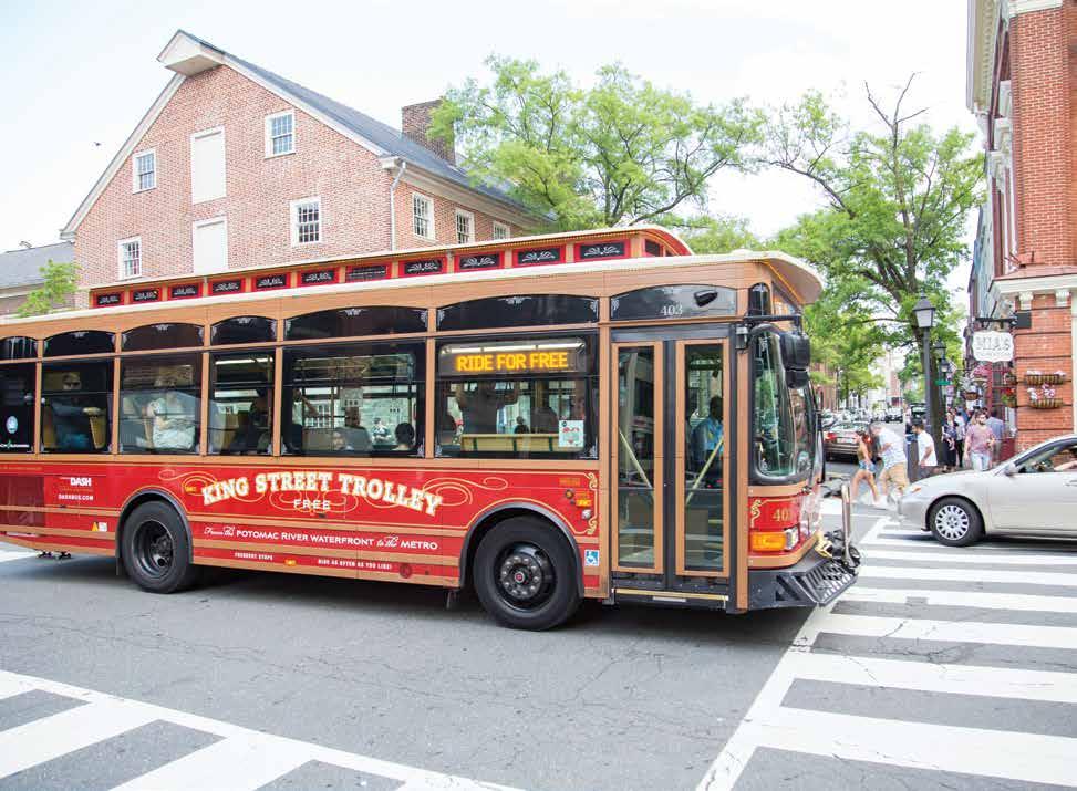
Free and simple, The King Street Trolley
only has one route: from the King Street Metro station to the Old Town waterfront and back, making stops along the way. It may feel a little touristy, but its yearround reliability makes it an excellent option if you’re running late (or just don’t feel like walking).
PHOTO BY BETH LAWTON
The Fairfax County Connector bus service
has several stops in southeastern Fairfax County, including the Mount Vernon area, Telegraph Road, Richmond Highway and Franconia Road. Times and stops can be found at fairfaxcounty.gov/connector.
The Washington Metropolitan Area Transit Authority (WMATA) runs the Metro rail (usually called “the Metro” for short) and the Metro bus systems in the District, Northern Virginia and parts of Maryland. The website at wmata.com and the WMATA app are excellent resources for planning your trip.
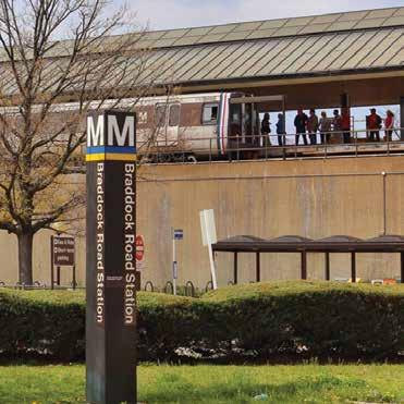
The Metro is a good option for getting in and out of the District. Alexandria’s six rail stops are on the blue and yellow lines. We recommend purchasing a SmartTrip card for $10 ($2 for the card itself, and $8 in stored fare value) at one of the kiosks located at the Metro rail stops. Fares fluctuate based on time of day and destination, but tend to range from $2.25 to $6 per trip.
You can also get into the District with the Virginia Railway Express (the VRE), which
primarily serves commuters and stops at the King Street train station, which also serves Amtrak. It travels up to Union Station in Washington, D.C.
Scooters, Bikes and Other Shared Mobility
Alexandria is home to many alternative modes of transportation, including Capital Bikeshare, which allows you to rent a bike for one-way, short trips all around Northern Virginia, the District and Maryland. Alexandria has several dozen Capital Bike Share docking stations across the City. Learn more at capitalbikeshare.com.


PHOTO BY R. KENNEDY FOR VISIT ALEXANDRIA
In addition, several national companies operate shared, dockless bikes and scooters, which you’ll find on sidewalks throughout Alexandria and elsewhere in Northern Virginia. The scooters can be unlocked with the scooter or bike company’s app. Learn the rules and more at alexandriava.gov/DocklessMobility.
Driving and Parking
How difficult it is to park in Alexandria depends on the neighborhood and time of day.
While every neighborhood has some free parking, you’re likely to encounter parking meters in much of the City in addition to pay parking garages. Pay close attention to parking signs – some neighborhoods restrict parking to certain times of the day or to only certain residential area permit holders. For paid street parking, meters are placed on every block where paid street parking is available, and the machines take cards or cash. You can also download the ParkMobile app to your phone to quickly pay for parking from your mobile device.
Registering your Vehicle
To get new license plates, you can swing by the Virginia Department of Motor Vehicles (DMV), at 2681 Mill Road in Alexandria. You may also be able to stop by a DMV Connect location, which is essentially a mobile DMV office, and you can take care of mosts tasks online. Go to dmv.virginia.gov for more information.
You must register your vehicle with the City of Alexandria or with Fairfax County after you move. Instructions and more information about how to do this are available on p. 32.
PHOTO BY BETH LAWTON
Biking Around Alexandria
Alexandria is one of the most bicycle-friendly cities in the United States.
“The City’s expansion of the Bikeshare program, installation and designation of new bike lanes and routes, as well as the continual installation of bicycle parking throughout the City are just a few of the initiatives that make the City of Alexandria a nationally recognized Bike Friendly Community,” according to Alexandria’s online bicycling guide at alexandriava.gov/Bicycling. In addition to that bicycling resource on the City of Alexandria’s website, the Washington Area Bicyclist Association has maps and documents to help you bike around town safely and easily. Go to waba.org/resources/ maps-and-documents.
You don’t need your own bike to cycle to work! The Alexandria area has more than 30 Capital Bikeshare stations – part of a regional bike sharing system with more than 500 stations in the District, Arlington, Alexandria, Fairfax County and nearby Maryland. Learn more at capitalbikeshare.com.
Fairfax CoArlington Co
Potomac River Anacostia River
Montgomery CoPrince George’s Co Prince George’s CoDistrict of Columbia Arlington CoFairfax Co District of ColumbiaPrince George’s Co Alexandria Alexandria Fairfax Co
System
Map Legend Under Construction wmata.com Information: 202-637-7000 | TTY: 202-962-2033 Metro Transit Police: 202-962-2121 | Text: MYMTPD (696873) Montgomery CoDistrict of Columbia No Smoking No Eating or Drinking No Animals (except service animals) No Audio (without earphones) No Littering or Spitting No Dangerous or Flammable Items
Blue Line • Franconia-Springfield / Largo Town Center Orange Line • New Carrollton / Vienna Red Line • Glenmont / Shady Grove Station Features Bus to Airport Parking Hospital Transfer Station Station in Service Green Line • Branch Ave / Greenbelt Airport Yellow Line • Huntington / Greenbelt Silver Line • Wiehle-Reston East / Largo Town Center Connecting Rail Systems
Metro is accessible. Map is not to scale WASHINGTON METROPOLITAN AREA TRANSIT AUTHORITY © 2019 B30 to BWI 5A to IAD West Falls ChurchVT/UVA 5AtoIAD Glenmont Wheaton Forest Glen Silver Spring Shaw-Howard U Arlington Cemetery Farragut West Metro Center Federal Triangle Smithsonian Eastern MarketCapitol SouthFederal Center SW Judiciary Sq Pentagon Pentagon City Waterfront Navy Yard-Ballpark Anacostia Congress HeightsSouthern AveNaylor RdSuitland Crystal City
Archives Navy Mem’l-Penn Quarter
Tenleytown-AUVan Ness-UDC Georgia Ave-Petworth Columbia Heights Mt Vernon Sq7th St-Convention Center Gallery Place Chinatown Court House
Ronald Reagan Washington National Airport Van Dorn St Braddock Rd King St-Old Town Eisenhower Ave Franconia-Springfield Huntington
Greenbelt College Park-U of Md Prince George’s Plaza West Hyattsville Fort Totten Spring Hill Wiehle-Reston EastGreensboroTysons Corner McLean U St African-Amer Civil War Mem’l/Cardozo Brookland-CUA Union Station NoMa-Gallaudet U Rhode Island Ave Brentwood Landover New Carrollton Cheverly Deanwood Minnesota Ave Vienna Fairfax-GMUDunn LoringMerrifield East Falls ChurchBallston-MUVirginia Sq-GMUClarendon Stadium-ArmoryPotomac Ave Morgan BlvdCapitol HeightsBenning Rd Addison RdSeat Pleasant
Shady Grove Rockville Twinbrook White Flint Grosvenor- Strathmore Takoma Medical Center Bethesda Friendship Heights Cleveland Park Woodley Park Zoo/Adams Morgan Rosslyn Foggy Bottom-GWU L’Enfant Plaza
Dupont Circle
Farragut North McPherson Sq
Kennedy Center National Mall Largo Town Center Branch Ave
Fairfax CoArlington Co
Potomac River Anacostia River
Prince George’s CoDistrict of Columbia Arlington CoFairfax Co District of ColumbiaPrince George’s Co Alexandria Alexandria Fairfax Co No Smoking No Eating or Drinking No Animals (except service animals) No Audio (without earphones) No Littering or Spitting No Dangerous or Flammable Items
Metro is accessible. Map is not to scale WASHINGTON METROPOLITAN AREA TRANSIT AUTHORITY © 2019 5A to IAD West Falls ChurchVT/UVA 5AtoIAD Shaw-Howard U Arlington Cemetery Farragut West Metro Center Federal Triangle Smithsonian Eastern MarketCapitol SouthFederal Center SW Judiciary Sq Pentagon Pentagon City Waterfront Navy Yard-Ballpark Anacostia Congress HeightsSouthern AveNaylor RdSuitland Crystal City
Archives Navy Mem’l-Penn Quarter
Tenleytown-AUVan Ness-UDC Georgia Ave-Petworth Columbia Heights Mt Vernon Sq7th St-Convention Center Gallery Place Chinatown Court House
Ronald Reagan Washington National Airport Van Dorn St Braddock Rd King St-Old Town Eisenhower Ave Franconia-Springfield Huntington
Prince George’s Plaza West Hyattsville Fort Totten Spring Hill Wiehle-Reston EastGreensboroTysons Corner McLean U St African-Amer Civil War Mem’l/Cardozo Brookland-CUA Union Station NoMa-Gallaudet U Rhode Island Ave Brentwood Landover New Carrollton Cheverly Deanwood Minnesota Ave Vienna Fairfax-GMUDunn LoringMerrifield East Falls ChurchBallston-MUVirginia Sq-GMUClarendon Stadium-ArmoryPotomac Ave Morgan BlvdCapitol HeightsBenning Rd Addison RdSeat Pleasant
Bethesda Friendship Heights Cleveland Park Woodley Park Zoo/Adams Morgan
Rosslyn Foggy Bottom-GWU L’Enfant Plaza
Dupont Circle
Farragut North McPherson Sq
Kennedy Center
National Mall Largo Town Center Anacostia River Branch Ave
Prince George’s CoDistrict of Columbia
District of ColumbiaPrince George’s Co No Audio No Littering No Dangerous or (except service animals) (without earphones) or Spitting Flammable Items
5AtoIAD Map is not to scale

Shaw-Howard U Metro Center Federal Triangle Smithsonian Eastern MarketCapitol SouthFederal Center SW Judiciary Sq Waterfront Navy Yard-Ballpark Anacostia Congress HeightsSouthern AveNaylor RdSuitland
Archives Navy Mem’l-Penn Quarter
Van Ness-UDC Georgia Ave-Petworth Takoma College Park-U of Md Prince George’s Plaza West Hyattsville Fort Totten Columbia Heights U St Brookland-CUA Farragut North African-Amer Civil War Mem’l/Cardozo McPherson Sq Mt Vernon Sq7th St-Convention Center Gallery Place Chinatown Union Station NoMa-Gallaudet U Rhode Island Ave Brentwood Landover New Carrollton Cheverly Deanwood Minnesota Ave National Mall L’Enfant Plaza Stadium-ArmoryPotomac Ave Morgan BlvdCapitol HeightsBenning Rd Addison RdSeat Pleasant Largo Town Center Fairfax CoArlington Co Ronald Reagan Washington National Airport Branch Ave Braddock Rd Potomac River King St-Old Town Eisenhower Ave Anacostia River Huntington
Montgomery CoPrince George’s Co Prince George’s CoDistrict of Columbia Arlington CoFairfax Co District of ColumbiaPrince George’s Co Alexandria Alexandria Fairfax Co
System Legend Under Construction
Information: 202-637-7000 | TTY: 202-962-2033 Metro Transit Police: 202-962-2121 | Text: MYMTPD (696873)
Montgomery CoDistrict of Columbia No Eating No Animals No Audio No Littering No Dangerous or or Drinking (except service animals) (without earphones) or Spitting Flammable Items
Blue Line • Franconia-Springfield / Largo Town Center Orange Line • New Carrollton / Vienna Red Line • Glenmont / Shady Grove Station Features Bus to Airport Parking Hospital Transfer Station Station in Service Green Line • Branch Ave / Greenbelt Airport Yellow Line • Huntington / Greenbelt Silver Line • Wiehle-Reston East / Largo Town Center Connecting Rail Systems Metro is accessible. Map is not to scale
B30 to BWI 5A to IAD VT/UVA
5AtoIAD
Glenmont Wheaton Forest Glen Silver Spring Shaw-Howard U Arlington Cemetery Farragut West Metro Center Federal Triangle Smithsonian Eastern MarketCapitol SouthFederal Center SW Judiciary Sq Pentagon Pentagon City Waterfront Navy Yard-Ballpark Anacostia Congress HeightsSouthern AveNaylor RdSuitland Crystal City
Archives Navy Mem’l-Penn Quarter
Tenleytown-AUVan Ness-UDC Georgia Ave-Petworth Columbia Heights Mt Vernon Sq7th St-Convention Center Gallery Place Chinatown Court House
Ronald Reagan Washington National Airport Van Dorn St Braddock Rd King St-Old Town Eisenhower Ave Franconia-Springfield Huntington
Greenbelt College Park-U of Md Prince George’s Plaza West Hyattsville Fort Totten Spring Hill Wiehle-Reston EastGreensboroTysons Corner McLean U St African-Amer Civil War Mem’l/Cardozo Brookland-CUA Union Station NoMa-Gallaudet U Rhode Island Ave Brentwood Landover New Carrollton Cheverly Deanwood Minnesota Ave East Falls ChurchBallston-MUVirginia Sq-GMUClarendon Stadium-ArmoryPotomac Ave Morgan BlvdCapitol HeightsBenning Rd Addison RdSeat Pleasant
Shady Grove Rockville Twinbrook White Flint Grosvenor- Strathmore Takoma Medical Center Bethesda Friendship Heights Cleveland Park Woodley Park Zoo/Adams Morgan Rosslyn Foggy Bottom-GWU L’Enfant Plaza
Dupont Circle
Farragut North
McPherson Sq Kennedy Center Fairfax CoArlington Co National Mall Largo Town Center Branch Ave Potomac River
Anacostia River
Montgomery CoPrince George’s Co Prince George’s CoDistrict of Columbia Arlington CoFairfax Co District of ColumbiaPrince George’s Co
System
Map Legend Under Construction wmata.com Information: 202-637-7000 | TTY: 202-962-2033 Metro Transit Police: 202-962-2121 | Text: MYMTPD (696873) Montgomery CoDistrict of Columbia
Blue Line • Franconia-Springfield / Largo Town Center Orange Line • New Carrollton / Vienna Red Line • Glenmont / Shady Grove Station Features Bus to Airport Parking Hospital Transfer Station Station in Service Green Line • Branch Ave / Greenbelt Airport Yellow Line • Huntington / Greenbelt Silver Line • Wiehle-Reston East / Largo Town Center Connecting Rail Systems B30 to BWI 5A to IAD West Falls ChurchVT/UVA
5AtoIAD
Glenmont Wheaton Forest Glen Silver Spring Shaw-Howard U Arlington Cemetery Farragut West Metro Center Federal Triangle Smithsonian Eastern MarketCapitol SouthFederal Center SW Judiciary Sq Pentagon Pentagon City Waterfront Navy Yard-Ballpark Anacostia Congress HeightsSouthern AveNaylor RdSuitland Crystal City
Archives Navy Mem’l-Penn Quarter
Greenbelt Tenleytown-AUVan Ness-UDC Georgia Ave-Petworth College Park-U of Md Prince George’s Plaza West Hyattsville Fort Totten Spring Hill Wiehle-Reston EastGreensboroTysons Corner McLean Columbia Heights U St African-Amer Civil War Mem’l/Cardozo Mt Vernon Sq7th St-Convention Center Gallery Place Chinatown Brookland-CUA Union Station NoMa-Gallaudet U Rhode Island Ave Brentwood Landover New Carrollton Cheverly Deanwood Minnesota Ave Vienna Fairfax-GMUDunn LoringMerrifield Court HouseEast Falls ChurchBallston-MUVirginia Sq-GMUClarendon Stadium-ArmoryPotomac Ave Morgan BlvdCapitol HeightsBenning Rd Addison RdSeat Pleasant Ronald Reagan Washington National Airport
Shady Grove Rockville Twinbrook White Flint Grosvenor- Strathmore Takoma Medical Center Bethesda Friendship Heights Cleveland Park Woodley Park Zoo/Adams Morgan Rosslyn Foggy Bottom-GWU L’Enfant Plaza
TRANSPORTATION
Dupont Circle
Farragut North McPherson Sq
Kennedy Center
National Mall Largo Town Center 30 Resident’s Guide Branch Ave


