8 minute read
The Allen Coral Atlas: Getting a Clear Picture of Coral Reefs Around the World
FEATURE CHANTEL SAY

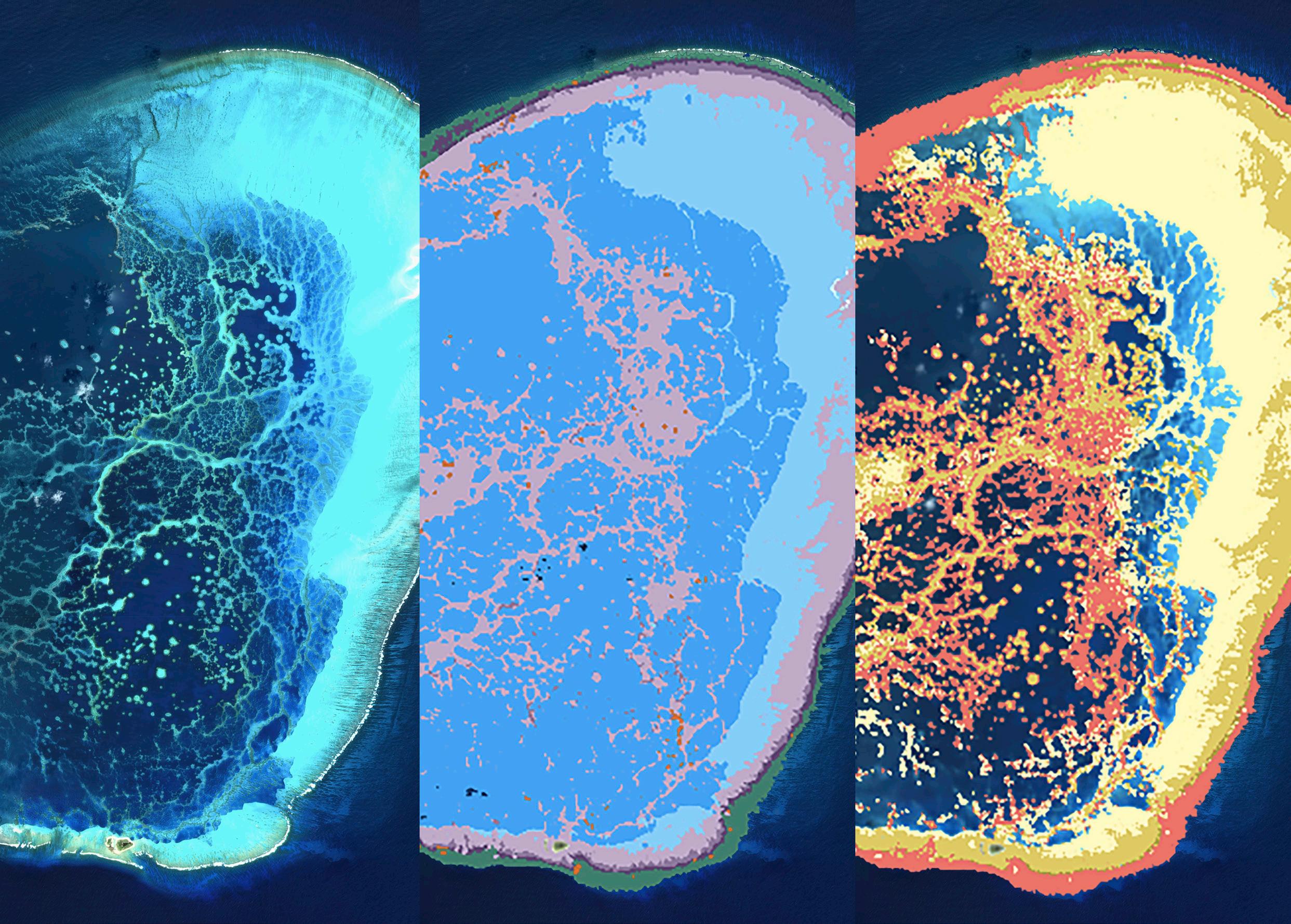
High resolution satellite image of a remote Hawaiian atoll (left), and its corresponding geomorphic (middle) and benthic habitat (right) maps produced by the Allen Coral Atlas.
Whether you are gaining a bird’s eye view from above, or immersing yourself beneath the water, it is easy to be transfixed by the beauty and biodiversity of coral reef ecosystems. With advances in technology, it is now not only possible to admire coral reefs from these two different perspectives, but also use these two approaches to help protect and preserve the future of these natural wonders. The Allen Coral Atlas is using high resolution satellite imagery and field observation data to produce a freely available global mosaic view of both the geomorphic and benthic habitat for all shallow-water tropical coral reefs around the world. This powerful new tool is the first of its kind, having the potential to support, inform and inspire critical action to protect and preserve coral reefs around the world.

Dr Chris Roelfsema expressing our overall goal for the Allen Coral Atlas – “Maps connecting people to help save reefs”. Photo by Dr Emma Kennedy.
WHO’S INVOLVED IN THE ALLEN CORAL ATLAS
This unique scientific tool for reef science began when Vulcan Inc. brought together champions in the fields of coral sciences, satellite imaging and mapping technologies. This included the late Dr Ruth Gates, a renowned and much-loved marine scientist, Andrew Zolli, who oversees the global impact initiatives of a game-changing satellite imagery company and Professor Greg Asner, a leader in aerial spectroscopy and remote sensing. Catalysed by Vulcan’s founder, the late Paul Allen, the vision was to create the world’s first global coral reef habitat map and monitoring system, describing the benthic nature across reef shelfs. Paul Allen, who is well-known for being Microsoft’s co-founder, was also a lifelong ocean enthusiast and avid diver and had charged his own team to “save the world’s coral reefs” and the Allen Coral Atlas was one initiative that came from his directive.
Although Dr Ruth Gates and Paul Allen are no longer with us, their aspiration to produce this global map has been facilitated by a group of passionate coral reef scientists and conservationists. The Allen Coral Atlas is an international collaborative partnership involving Planet Labs Inc., The Arizona State University’ s Centre for Global Discovery and Conservation Science, The University of Queensland’ s Remote Sensing Research Centre, the National Geographic Society and Vulcan Inc., with each partner playing a critical role in the development of this innovative scientific tool for reef science, helping to gain a clearer picture of coral reefs around the world.

Overview of the Allen Coral Atlas, displaying the benthic habitat map and class legend for Heron Island, the Great Barrier Reef, Australia. The statistical analysis (panel on the bottom right) shows the output for both the geomorphic and benthic makeup for a specific portion of the reef (outlined).
WHAT DOES IT TAKE TO CREATE THE WORLD’S FIRST GLOBAL CORAL REEF HABITAT MAP
Given that it is not feasible to visit and study every single reef around the world, the Allen Coral Atlas has developed cutting-edge technology to automate the mapping of coral reef habitats based on high resolution satellite imagery. This high-resolution satellite imagery is obtained by hundreds of Planet Dove nanosatellites that orbit the earth on a daily basis. These satellites are roughly the size of a shoebox and provide the Atlas with a seamless 3.7 m resolution mosaic of the world’s reefs. This imagery is further corrected by the Arizona State University (ASU) team led by Professor Greg Asner, removing cloud cover, sun glint and other atmospheric interferences, to allow a clarity never before seen using satellite imagery.
This clear view of the reefs combined with georeferenced benthic field data allows a team of GIS and coral reef biologists from the University of Queensland, led by Dr Chris Roelfsema, to consistently describe the benthic nature of coral reefs (on a region-by-region basis). Specifically, describing the habitat which falls within multiple predefined 20 x 20 m training reference samples within each region.
These reference samples are fed through an automated machine learning mapping process, and then through an object-based clean-up process, to create a geomorphic and benthic habitat map that spans the entire region, encompassing all visible reefs (not influenced by turbidity or deep water). Once each region is mapped, it is released onto the Allen Coral Atlas website, freely available for exploration and download. The Allen Coral Atlas also provides an analytical tool which can be used to calculate the proportion of geomorphic and benthic habitat features within a particular reef or region of interest, that has been mapped. If you are interested in learning more about the methods behind these maps, please visit the Science and Methods section on the Allen Coral Atlas website for further information.
In addition to providing global satellite imagery and the two mapped layers, the Allen Coral Atlas is also planned to feature a monitoring tool for coral bleaching events globally. Professor Greg Asner and the team at ASU are currently creating a dynamic brightening alert layer that detects and uses changes in the spectral signature of corals as a proxy for bleaching events.

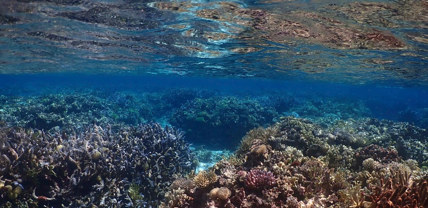
The coral reef on Heron Island, the Great Barrier Reef, Australia. Photo by Dr Emma Kennedy.
WHY IS THE ALLEN CORAL ATLAS A POWERFUL TOOL
The Allen Coral Atlas uses global consistency to map all the shallow tropical reefs of the world, drawing us closer towards a complete global geomorphic and habitat mosaic map. The Allen Coral Atlas uses the same mapping techniques and class descriptions to allow scientific comparisons between any reef. Secondly, the Allen Coral Atlas is free to anyone and everyone. Due to its open access, and freely available user guides, this easyto-use scientific tool will allow for scientific benthic analysis to be undertaken for even the most remote and least studied reefs around the world. The Allen Coral Atlas is therefore pushing the boundaries of our current spatial knowledge of coral reefs, to a point where we can gain a more comprehensive understanding of coral reefs and their benthic nature around the world.
Headed by the National Geographic Society, the Atlas team prioritises field engagement to ensure that coral reef managers, scientists, and conservation practitioners have the resources necessary to use the maps for a high level of impact. The Allen Coral Atlas, in association with The Nature Conservatory, has produced free online courses to provide further background and information on the application of remote sensing and coral reef mapping. The Allen Coral Atlas and its resources can thus be used to address current knowledge gaps and to implement conservation and management applications.

Dr Chris Roelfsema and Professor Stuart Phinn examining a high-resolution satellite image of Heron Island whilst in the field. Photo by Dr Megan Saunders.
HOW YOU CAN HELP
As the Allen Coral Atlas has now mapped 67% of the world’s shallow-water tropical coral reefs, it is not long now until the coral reef community has a complete global geomorphic and benthic habitat map on hand. However, the collection of field data used to help with the creation of these Atlas maps has been severely impacted due to the COVID-19 pandemic. Therefore, we are seeking your help. In fact, members within the coral reef community have already rallied behind the Allen Coral Atlas, sharing benthic data to help make the Atlas maps as reliable as possible – an effort we are extremely grateful for. With the mapping of the Middle East scheduled next, we are thus seeking your help with the collection of georeferenced benthic data that can help us describe and identify the benthic habitat of these coral reefs. Such data could consist of georeferenced photoquadrats, image mosaics or existing habitat maps. Additionally, groundtruth point data that has a recorded GPS location per data point is also extremely helpful. If you believe that you have georeferenced benthic data that could help with our mapping efforts, please contact us via submissions@allencoralatlas. com – we’d love to hear from you. All data shared with the Allen Coral Atlas will only be used internally and not shared or published outside our team and all data sets used to help with the calibration and validation of the Allen Coral Atlas maps will be attributed on the website.
With your help, the Allen Coral Atlas can support, inform and inspire critical action to protect and preserve the world’s coral reefs.

Field surveys being conducted in the Bahamas by Kathryn Markey. Photo by Dr Chris Roelfsema.
To access the Allen Coral Atlas and for more information regarding the collaborative partners behind the Atlas, please see the following information below.
You can access the Allen Coral Atlas via the following link: https://allencoralatlas.org
The Allen Coral Atlas has now mapped 67% of the worlds shallow-water tropical coral reefs. You can explore all these reefs and download the maps through the Atlas: https://allencoralatlas.org/ atlas/#3.09/-4.7098/98.2806
To find out more about those involved in this international collaborative partnership, you can visit our website here: https://allencoralatlas.org/ partners/
Additionally, you can visit each of the contributing partners’ websites:
• Planet Lab Inc.: https://www.planet.com
• The Arizona State University’s Centre for Global Discovery and Conservation Science: https://gdcs.asu.edu
• The University of Queensland’s Remote Sensing Research Centre: https://www.rsrc.org.au
• The National Geographic Society: https://www.nationalgeographic.org
• Vulcan Inc.: https://vulcan.com
For more information regarding the science and methods involved in the Allen Coral Atlas, and how to best apply this scientific tool, please see below.
• Learn more about how Planet Lab obtains the most comprehensive and up-to-date highresolution satellite imagery here: https://www.planet.com/company/approach/
• You can learn more about the science and methods behind the Allen Coral Atlas, its maps, monitoring programme and scientific analysis tools here: https://allencoralatlas.org/methods/
• If you want to learn how to best interpret and use the Allen Coral Atlas maps, or just want to learn more about remote sensing and mapping for coral reef conservation, then please feel free to sign up to our three free online courses: https://reefresilience.org/new-online-courseremote-sensing-mapping-for-coral-reefconservation/
• To see all the coral reef community members who have contributed data to help with our mapping efforts, you can visit the attribution page of the Allen Coral Atlas here: https:// allencoralatlas.org/attribution/


