
Eminent Domain & Yellowstone


Eminent Domain is the power vested in the state as sovereign to take private property for public use without the consent of the owner, whenever necessity demands, and upon paying just compensation.

Sources of Authority
1. Art. X, S. 6, Florida Constitution: “No private property shall be taken except for a public purpose and with full compensation therefor paid to each owner or secured by deposit in the registry of the court and available to the owner.”
2. Florida Statutes Authorizing Specific Entities to Acquire Property:
a. §§ 166.401, 166.411, Fla. Stat.: Municipal Powers of Eminent Domain
b. §§ 127.01, 127.02, Fla. Stat.: County Powers of Eminent Domain

c. Other government entities with the power of eminent domain:
i. Expressway Authorities;
ii. Water Management Districts; and
iii. State Agencies.
An entity that exercises condemnation powers bears an initial burden to demonstrate that the property being acquired is intended for a public purpose and is reasonably needed in order to accomplish that public purpose. City of Jacksonville v. Griffin, 346 So. 2d 988, 990 (Fla. 1977).

Examples of When Eminent Domain is Employed


1. (1) Notwithstanding any other provision of law, including any charter provision, ordinance, statute, or special law, if the state, any political subdivision as defined in s. 1.01(8), or any other entity to which the power of eminent domain is delegated files a petition of condemnation on or after the effective date of this section regarding a parcel of real property in this state, ownership or control of property acquired pursuant to such petition may not be conveyed by the condemning authority or any other entity to a natural person or private entity, by lease or otherwise, except that ownership or control of property acquired pursuant to such petition may be conveyed, by lease or otherwise, to a natural person or private entity:
…
§§ 73.013 Fla. Stat.: Eminent Domain Procedures

“GEOGRAPHY” OF YELLOWSTONE
• Dutton Ranch – 800K acres along Yellowstone River in southern Montana

• Yellowstone National Park and Wyoming State Line to south
• Rocky Mountains to the west
• Broken Mountain Reservation to east
• Fast growing City of Bozeman to northwest

“GEOGRAPHY” OF MIAMI-DADE

• 1,965 sq. miles (1.2 M+ acres)
• Everglades NP to west, Biscayne NP to east
• Tribal lands
• Developed area 23% of land area (approx. 300K acres) – only 2% vacant/privately owned (>40K acres)
• Development pressure from urban area
• Significant rural economy (agriculture, rock mining)
• Natural, historic, cultural, archaeological resources

AMERICAN DREAM MALL /GRAHAM PROPERTIES APPLICATIONS
• In 2016 two applications to amend the CDMP were submitted to the County:
1. Retail/Entertainment project that, if approved, would be the largest mall in the U.S.
2. A separate but related mixed-use development located south of the proposed mall site

• Transferred to the next available Cycle (May 2016) to allow more time to provide the necessary information
• Approved in May 2018
• Construction not yet started (in planning stage)

AMERICAN DREAM MALL APPLICATION

• Location: North of NW 178 Street between Turnpike and I-75
• Size: 174.83 gross, 150.12 net acres
• Request:
• Amend LUP Map from Industrial and Office to Business and Office

• Delete .45 FAR for area west of NW 97 Avenue
• Release existing and add a new Declaration of Restrictions
• Amend the Transportation Map series
GRAHAM PROPERTIES APPLICATION

• Location: Between HEFT and I-75 and NW 170 and 180 Streets
• Size: 339 gross, 323.6 net acres
• Request:
• Amend LUP Map from Industrial and Office and Business and Office to Business and Office
• Release an existing and add a new Declaration of Restrictions

AMERICAN DREAM MALL PROPOSAL
• Current CDMP designation allows Industrial and Office, FAR restricted to .45 west of NW 97 Ave.
• Over 55K s.f. office
• 95K s.f. Business Park
• 3 million s.f. warehouses
• Requested CDMP Designation to allow Business and Office
• 6.2 million s.f entertainment/retail venue
• 2,000 hotel rooms
• Declaration of Restrictions limiting development on property to…

• 3.5 million s.f. of retail
• 1.5 million s.f. of entertainment

• 2,000 room hotel
• 1.2 million s.f. of common areas or back of house uses
GRAHAM PROPERTIES PROPOSAL

• Current CDMP designation allows Industrial and Office
• Over 240K s.f. office
• 400K s.f. business park
• 3 million s.f. warehouse
• Requested CDMP Designation to allow Business and Office, proposed Employment Center on 280 acres west of NW 97th Ave

• First phase 150,000 s.f. retail
• 250,000 s.f. business park
• 500 MF
• Declaration of Restrictions limiting ultimate build-out on property to...
• 1 million s.f. of commercial
• 3 million s.f. of business park
• 2,000 multi-family residential uses
• Committing to an employment center west of NW 97th Ave
AMERICAN DREAM MALL PROS AND CONS
PROS:
Job Creation: Est. 14,500 jobs

Consistent with the recommendations of the 2011 Retail/Entertainment District Assessment (RED) Report
Re-designation would not reduce the supply of industrial land below the 15-Year supply
Opportunity for a more detailed plan of development than what might otherwise occur under the current designation
CONS:
Applicant must adequately demonstrate how site will be served by mass transit
No proof roadway improvement needs will be met
Applicant must adequately demonstrate how stormwater infrastructure and fire rescue needs will be met
Applicant must further identify the extent of wetlands, and provide a mitigation plan
Applicant must provide appropriate wildlife studies, and mitigation
Applicant must develop a plan for the preservation of three archeological sites
Applicant must demonstrate how proposed uses will be consistent with rock mining
GRAHAM PROPERTIES PROS AND CONS
PROS:
Job Creation: Est. 9,950 jobs

Commercial land supply in the area will be depleted after 2030 – application will add 323 new acres of commercial land, extending the depletion date by 5.3 years
Re-designation would not reduce the supply of industrial land below a 15-Year supply
Opportunity for a more detailed plan of development than what might otherwise occur under the current designation
CONS:
Applicant must adequately demonstrate how site will be served by mass transit
Applicant must demonstrate how roadway improvement needs will be met
Applicant must adequately demonstrate how stormwater infrastructure and fire rescue needs will be met
Applicant must further identify the extent of wetlands, and provide a mitigation plan
Applicant must provide appropriate wildlife studies, and mitigation
Public Schools and Parks needs
RECOMMENDATIONS FOR THE APPLICATIONS

The May 2016 Cycle CDMP Amendment Application No. 5 (with change) and 6 be transmitted with the Proffered Declarations of Restrictions as recommended by staff, and with the following conditions:
1. Provide private shuttle bus services for the communities on NW 186th Street.


2. Keep NW 170th Street bridge [over I-75] closed

PROPOSALS TIMELINE


APPLICAIONS FILED
Both applications were filed with the County to amend the CDMP
TRANSPORTA TION IMPACT ANALYSIS
BCC AUTHORIZED TRANSMITTAL
Miami-Dade BCC authorized transmittal to DEO and the review agencies.
BCC ADOPTED AMMENDMENTS
BCC adopted the amendments as transmitted with further changes recommended by staff.
DRI PROCESS
Both applicants agreed, to answer 21 relevant questions from the list of DRI questions that were required under the previous process. Both projects would have met the threshold for consideration as DRIs under the former process
SFRPC INTERGOVERNMENTAL MEETINGS
Held to receive feedback and input at various stages
EXTENSION REQUEST
Filed in January, extension provided
AMERICAN DREAM MALL & GRAHAM PROPERTIES
2040 Cost Feasible & Planned Network


AMERICAN DREAM MALL & GRAHAM PROPERTIES

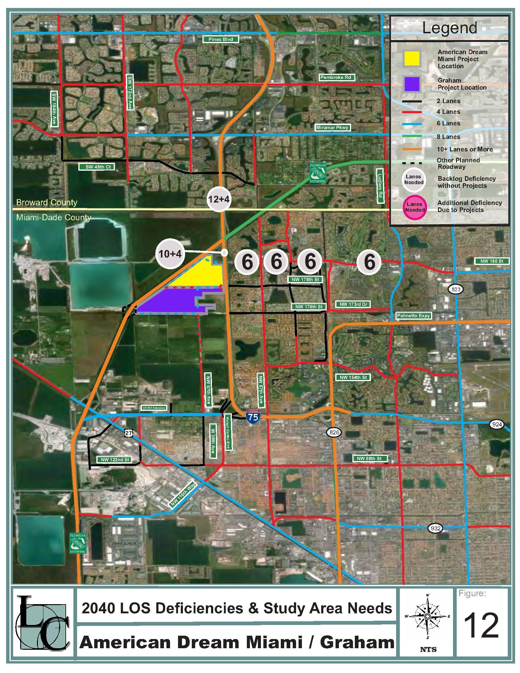
2040 LOS Deficiencies & Study Area Needs


ALIGNED APPLICATION

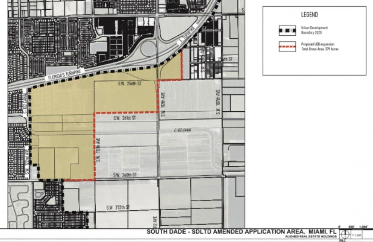
• Location: South of the Homestead Extension of Florida Turnpike (HEFT), between SW 107 Avenue and SW 122 Avenue, north of SW 268 Street/Moody Drive

• ± 793.93 gross acres/± 722.33 net acres
• UDB Expansion Application
ALIGNED PROPOSAL
• Aligned is proposing to expand the 2030 Urban Development
Boundary (UDB) to…
Redesignate the application site on the Land Use Plan map from “Agriculture” to “Special District”.
Amend the interpretative text of the Land Use Element to create the “South Dade Logistics & Technology District”

Amend Policy LU-8H in the CDMP Land Use Element

Amend Policy CM-9A in the CDMP Coastal Management Element
Add the five Proffered Declarations of Restrictions in the Restrictions Table in Appendix A of the CDMP Land Use Element, if accepted by the board (Covenants for Phase I, Phase IIA, Phases IIB, IIC, IID)
• Potential Development – Current “Agriculture” LU:
• 158 single family rural residences
ALIGNED DEVELOPMENT PROGRAM
• Phase I (Aligned Real Estate Holdings LLC) - 203.58 acres
•Up to 2,696,935 SF of industrial uses
•Up to 20,000 SF of supportive commercial
•Covenant limits development program
• Phase II (South Dade Industrial Partners et al) - 165.26 acres

•Up to 2,350,700 SF of industrial uses
•Up to 80,000 SF of supportive commercial
•150 room hotel
•Covenants limit development program
• Phase III (Not owned/under contract by applicants) - 424.44 acres
•Up to 4,277,234 SF of Industrial Uses

•Up to 20,000 SF of supportive commercial OR
•84 single family rural residences
•No covenant
ALIGNED CONCERNS
DOES NOT MEET NEEDS ANALYSIS + UNDERMINES UDB INFILL:
No job guarantees are provided - no evidence of confirmed tenants to create the 11,762 jobs.
Applicant’s economic study estimates over two times as many jobs as the traffic study analyzes, which points to undercounted traffic counts or overestimated job creation.
Fails to demonstrate the need to expand the Urban Development Boundary when an adequate supply of vacant industrial land already exists inside the UDB.
County policy prioritizes infill development within UDB.
Prioritization of infill directs development to vacant or underdeveloped areas where public facilities and services already exist.
The acreage in the application would extend the depletion of industrial land in the South tier by over 100 years.
Commercial sites greater than 10 acres inside the UDB that could be repurposed for distribution and logistics.
Miami-Dade County has an excess of industrial rentable building area per capita compared to the national average.

ALIGNED
CONCERNS
DOES NOT MEET NEEDS
ANALYSIS + UNDERMINES UDB INFILL


ALIGNED CONCERNS
DOES NOT ADEQUATELY ADDRESS INFRASTRUCTURE + DESIGN:


• Fails to demonstrate how the infrastructure required to support the development will be provided in a sound and fiscally responsible manner.
• Fails to demonstrate how the development will comply with County requirements for how new lands brought into the UDB are to be developed.
ALIGNED CONCERNS
Failure to Demonstrate Level of Service (LOS)
Standards in TRANSPORTATION:
• A comprehensive analysis of roadway network required for all three phases was NOT done.
• Sufficient roadway network has NOT been planned and dedicated for the distribution of trips generated from the project site.
• Maximum trip cap in covenants show incorrect calculations and NOT adjusted to reflect revised development program
• Applicant’s traffic analysis identifies roadways that fail level of service standards and need to be mitigated.

• DTPW requires additional analysis to determine full impacts.
DOES NOT ADEQUATELY ADDRESS INFRASTRUCTURE + DESIGN

ALIGNED CONCERNS
Failure to Demonstrate Level of Service (LOS)
Standards in TRANSIT:

• 20-minute headway required, but Route 35 reduced to 30 minutes by BCC.
• Route 35 does not serve the entire application site.
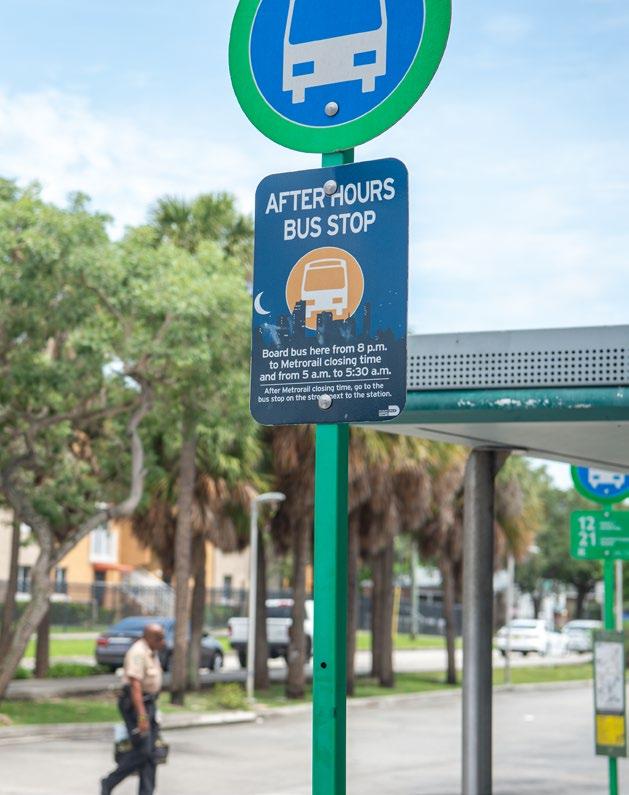
• Applicant must mitigate with a new bus, bus shelters, and bus stops.


DOES NOT ADEQUATELY ADDRESS INFRASTRUCTURE + DESIGN
Cowboys Vs. Indians – Systematic Discrimination

The land of the Dutton family ranch was originally for everyone to live with the land, not on it.
The land didn’t belong to anyone, it belonged to everyone and was taken from the people of the First Nation by force and murder. Broken treaty, after broken treaty.
Two recent books provide background to the consistent theme in the show about how the land where the ranch is was stolen from the Native tribe, who now live on a reservation.
The US Army’s staged a systemic campaign to control the West and all the people of the First Nation by forcing them to live on reservations or by murder if they didn’t corporate. Ending with the 40 year war against the Comanches, who were considered the best horsemen that ever rode.


The people of the Osage Nation were part of the forcible displacement of Native Americans by the United States government in the 19th century. Eventually, the Osage settled in "Indian territory," in modern-day Oklahoma. Their people legally purchased the reservation land, which made it more difficult for the U.S. government to impose a system of "allotment," under which Native land was carved up and given away to white settlers. The Osage legally bought head rights to the land, which couldn’t be sold, only inherited. They owned mineral rights on their land, and were millionaires when oil was discovered near Stillwater Oklahoma in the 1920s.


Adults legally couldn’t have control of their own money, they had to have a white man control their finances. They were systematically robed, cheated and murdered and it was overlooked by authorities.
They were not white. Virtually every element of society was complicit in this murderous system. And most of them escaped with zero accountability and millions in Osage wealth.


My mother, her parents all my aunts, uncles and cousins lived there.
My cousin’s grandfather, on her father’s side was one of the attorney’s that helped facilitate the financial dealings of the Osage.

My cousin told me that it was because the Osage needed help with finances and trusted him.


