9 minute read
High-risk rural roads: what can be done to make them safer?


Martin D. Calawa, P.E.
Safety & Operations Engineer Federal Highway Administration, New Hampshire Division Office Concord, New Hampshire
Advertisement
oad safety is everyone’s business whether you are a facility owner or just a private citizen who drives on them. However, owner and maintainer have the unique opportunity to actually address the roadway environment and features to improve safety for us all.
Rural roads have the dubious distinction of accounting for well over half of the highway fatalities in the U.S., while carrying less than 40 percent of the traffic. According to the 2009 Census, 23 percent of the U.S. population lived in rural areas; however, rural fatalities accounted for 57 percent of all traffic fatalities. Recognizing this issue the U.S. Congress established the High Risk Rural Roads Program (HRRRP) as part of the 2005 passage of the Safe, Accountable, Flexible, Efficient Transportation Equity Act: A Legacy for Users (SAFETEA-LU). Each state is allocated funds to their state highway agency to be used to address safety concerns on high-risk rural roadways—those roadways functionally classified as “Rural Major & Minor Collectors” or “Rural Local Roads” that are at a higher risk of having fatal or serious injury crashes, i.e., that have a higher than average crash experience.
State and local highway agencies have generally found this program difficult to implement and project funding obligations are not as high as other federal safety programs. The reasons for this are many and emphasize the general problem with addressing safety on local roadways. One of the main reasons is simply the problem with identifying sites with high crash rates, and then making meaningful improvements at these locations given the limited funds available.
Locating traffic crashes accurately can be challenging for roadway owners, but this is especially so on the rural locally-owned roadway systems. Severe crash data elements (e.g., location, crash type) are usually available in most state databases; however, the report site information may very well not match the actual location of the crash.
Municipal and county roadways often do not have mile markers for police to clearly identify crash sites. Crashes are usually recorded as between intersections or at street addresses. In rural areas, intersections are far apart and property sizes are large so the precision of this data is lacking. Attempts to address seeming high crash locations on some rural roads in New Hampshire, my home state, highlighted this issue. New Hampshire uses a nodal system, like many states do, with nodes at easily identifiable sites such as intersections and major highway features. New Hampshire found that a number of high crash locations on state-owned roads reportedly
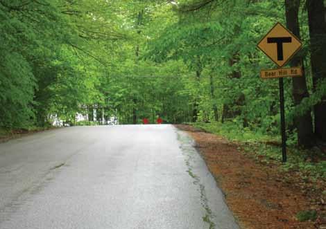
This T-Symbol warning sign (W2-4) provides warning of the road ending at a cross street just beyond the crest of the vertical curve. To further define the location of the end, Type 4 Object Markers (OM4-3) are added as seen in the distance.
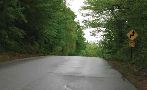
The use of a Reverse Curve Ahead symbol warning sign (W3-1) with advisory speed plaque is a simple cost-effective way to warn of a set of significant changes to the roadway horizontal alignment obscured by the crest of a hill.
happened right at town lines, which coincidentally is an easy node for police to remember.
This lack of good crash location information makes site-specific safety improvement investment decisions difficult. Trying to normalize crash distributions by considering traffic volumes is equally difficult; accurate rural road traffic volumes just don’t exist in most states. Throw in the fact that crashes are generally random in distribution on the roadway and you can see why many agencies shy away from tackling this problem.
In light of these issues it often seems impossible to roadway owners to meaningfully address safety issues on these rural roadway systems; but what if the problem is approached from another direction? Instead of just trying to identify site-specific high crash locations, to specifically address the crash types occurring at those spots alone, the features often known to be a safety issue on rural roads are identified and address all the sites having similar features. This doesn’t mean data isn’t needed anymore to addressing safety on rural roads; it simply means some different data is used in a different way.
The systemic approach is designed to address high-risk roadway features that are correlated with particular severe focus crash types. If some of the roadway features, or possibly the lack of roadway features, can be identified that contribute to specific crash types then targeted safety countermeasures can be applied to all sites with similar features. Maybe an example will help.
The national Fatal Accident Reporting System (FARS) data shows that over 80% of New Hampshire’s roadway fatalities occur on rural roads. Similarly, New Hampshire’s data shows that approximately 40% of this state’s fatal and severe injury crashes occur at horizontal curves. Clearly, drivers in New Hampshire are having trouble negotiating a number of horizontal curves on rural roads and end up running off the road (a crash type) with severe consequences. The next question to be asked is, what roadway features contribute to drivers leaving New
You’ve spent time in the public works trenches, now make the move to a desk!
The DCS Center provides the education you need to help you develop a better understanding of the various public works agency responsibilities, applicable technologies and issues facing managers. By participating in the program, you’ll be showing your commitment to the profession and working towards a nationallyrecognized credential.
Find what you need to make your next move by visiting www.apwa.net/dcs!
www.apwa.net/dcs
Hampshire rural roads on curves? A few possibilities come to mind: minimal radius of curvature, lack of visual indication of the curve ahead, lack of information on the sharpness of the curve, low roadway friction, etc. If the lack of a visual indication to the driver that there is a curve just ahead is a critical contributing feature to crashes, then a countermeasure of advanced curve ahead warning signs may be chosen to address the issue. With that countermeasure identified, it is a simple matter of determining which curves will receive this treatment.
Determining where to apply this countermeasure may include determination of the crash frequency or rate at each site. However, regardless of the number of crashes or the calculated crash rate at any particular site, all sites with poor visual indication of a
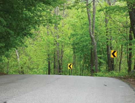
Chevrons (W1-8) are one of the most effective horizontal curve warning signs as they also provide clear delineation of the path as you go. Here chevrons clearly make the alignment of this road which would otherwise be very difficult to determine.
Working In Harmony With Nature


Modular Bioretention System
• Meets standard bioretention cell design • Local agency low flow (5-10 in/hr) or high flow soils • Modular design for consistent dimensional tolerances and reduced construction costs • Infiltration or detention designs • Precast concrete for structural integrity
www.kristar.com 1-800-579-8819
curve ahead carry a strong likelihood of experiencing this specific type of crash in the future. Therefore, a more effective way to approach this would be to simply identify all curves with similar features that lack the advance curve ahead warning signs and then applying this countermeasure to them. Identifying the specific curves meeting your criteria for applying this countermeasure can be done by reviewing roadway characteristics data or, lacking that, by a simple field review or use of mapping technology (i.e., Google maps); all can be effective.
The prior example is based on run-off-the-road crash types occurring on roadway segments, but the same approach can just as easily be applied to intersections crashes, another common highcrash location on rural roadways. One systemic tool developed by the FHWA to address safety at intersections is the Intersection Safety Implementation Plan Process, publication FHWA-SA-10-010. This publication describes a process that starts with the determination of a set of low-cost, effective countermeasures that the state would be comfortable deploying and searches the crash data system to identify intersections where the countermeasures can be deployed cost-effectively. This approach is not limited to the highest crash locations. Typically, it focuses on treating the 3-6 percent of the intersections at which 25-45 percent of the targeted intersection crashes exist. The countermeasures to be used may or may not specifically address crash types known at specific locations; rather they address common crash types generally known to be issues in the state or region as a whole. As you may be thinking now, how do I afford a systemic approach that identifies so many potential mitigation sites with so many potential countermeasures? The key to achieving this is to keep the cost of the safety countermeasures you choose to implement low. Many low-cost safety treatments for roadway segments or intersections have been shown to be very effective with high benefit-to-cost ratios. It may also be the case that highercost solutions are required to address a specific and severe safety problem at a given location. No one is suggesting that these highercost safety improvements are not prudent for dealing with certain high-crash sites, but in the long run using the systemic approach to safety improvement is an effective way to address those random crashes plaguing our rural roadways and driving down the number of people seriously hurt, or worse, on them.
For more information on addressing roadway safety check out these FHWA sites:
• Proven Countermeasures webpage: http://safety.fhwa.dot. gov/provencountermeasures/
• Noteworthy Safety Practices: http://rspcb.safety.fhwa.dot.gov/ noteworthy/default.aspx
• Implementing the HRRRP: http://safety.fhwa.dot.gov/local_ rural/training/fhwasa10012/
Martin Calawa has been with the Federal Highway Administration for 23 years serving in various capacities in several states. He presently holds the position of Safety & Operations Engineer for FHWA’s New Hampshire Division. He can be reached at (603) 228-3057 or martin.calawa@ fhwa.dot.gov.
If you’ve got more than 20 years of public works experience, the DCS Center offers you a chance to give back to the public works community by lending your real-world knowledge to fellow DCS participants as they move through the program. You’ll also have the opportunity to learn just how important your knowledge has become and how you can leverage that experience to become a better leader to your staff.


