6 minute read
Global Solutions in Public Works
School zone safety in New Zealand
Kevin Chang, Ph.D., P.E.
Advertisement
Traffic Engineer, King County Department of Transportation Seattle, Washington 2012 Jennings Randolph Fellow
t the outset of my presentation on school zone safety at this year’s INGENIUM conference in Rotorua, New Zealand, I posed two questions to the audience. If you have a shared passion in school travel or travel behavior then you might recognize these questions as a common way to both engage the audience and to showcase the degree to which school travel behavior has evolved and changed over time.
Did you walk or bike to school as a child? Do you allow your children to walk or bike to school?
After a quick tally on the number of hands raised for each question, the results from our New Zealand counterparts mirrored those from my previous presentations in the United States; today’s schoolaged children are not walking or bicycling to school as frequently as their parents. This article shares some of the current practices in New Zealand to promote and encourage non-motorized travel to school.
Signage and markings
The New Zealand roadway network is robust and well-maintained, and the country’s enchanting natural beauty pleasantly distracted me as I traveled from community to community in my high-mileage rental car (with a right-side steering wheel). Along the way, I could not help but notice many striking similarities after comparing the school safety treatments utilized by engineers and planners in our two countries.
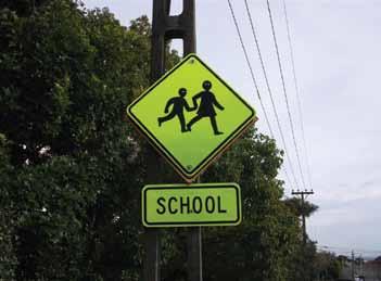
To encourage walking and bicycling, a safe travel environment between home and school is essential. The silhouette for the school sign, shown in Figure 1 (p. 28), is slightly different than the graphic used in the United States, but the usage of a “SCHOOL” placard to distinguish a school crossing from a standard pedestrian crossing is similar. All school signs feature the fluorescent yellow-green background, which is consistent with current MUTCD (Manual on Uniform Traffic Control Devices) guidelines in America. The shape of the New Zealand school sign, however, is diamond as opposed to pentagonal. At school crossings, a sign with a crosswalk image complements orange object markers (see Figure 2 on p. 28), though some object markers have been replaced with illuminated orange globes to provide additional visibility.
A raised refuge median island, as shown in Figure 2, can be installed to provide an additional physical buffer for the school child crossing the street. Figure 3 (p. 28) shows a school crossing in a centralized urban setting without a median island.
When there is a need to make the driver more aware of his or her surroundings, signage featuring flashing lights or illumination is used. Two electronic signs that are used by local jurisdictions and feature these enhancements are shown in Figures 4 and 5 (p. 28).
In Figure 4, the school silhouette is complemented with beacons that are programmed to flash during appropriate school hours. In Figure 5, an illuminated school speed sign, turned on during morning arrival and afternoon dismissal periods, offers guidance to drivers that the regulatory speed along the roadway is reduced during times when school children are likely to be present. (For more information on an innovative walking and cycling initiative in New Plymouth, go to www.letsgo. org.nz.)
Both photos show the use of solar panel technology that provides power to these signs. The challenges associated with turning the sign on and off at the appropriate times, along with ensuring that there was sufficient solar power, were similar to those encountered by technicians in the United States.
Roadway markings represented another means of promoting and encouraging driver awareness. Figures 4 and 5 also depict colorized pavement as a means of emphasizing a school zone and bicycle lane. Figure 6 (p. 28) shows an example of a lane marking in a school area.
Rural communities
Rural communities face different school zone safety challenges than
their counterparts in larger cities. In these areas, students may need to rely on a school bus or parent pickup and drop-off as the distance from home to school may be impractical for a child to travel alone or adequate infrastructure in the form of a sidewalk or bicycle lane may simply not exist.
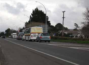
Figure 7 (p. 29) shows a typical school bus route sign, with a graphic that resembles the image used in the United States. Figure 8 (p. 29) shows a queue of cars in the twoway, right-turn lane into a school during afternoon dismissal pick-up. The queue extended from the school driveway onto the main roadway fronting the school because there was not enough storage capacity on school grounds to handle the traffic volume. This scenario will likely ring true for any traffic engineer who must deal with congestion issues in the vicinity of his or her school during afternoon dismissal.
Outside the city of Hastings, the Clive School is sited on a straight and flat section of School Road, which also doubles as a local bypass route. There are a limited number of houses fronting the street, and the sidewalk facilities approaching the school are generously separated from the roadway. The school building could easily be mistaken for a commercial office building. With all of these factors in place, it created a challenging school safety environment caused by higher vehicle speeds throughout the day that ultimately resulted in an extensive, multi-year effort between the school principal, staff from the Hastings Regional Council, and local enforcement.
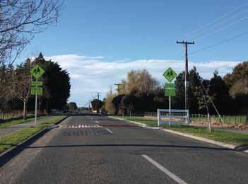
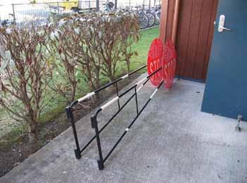
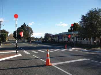
Figures 9 and 10 (p. 29) showcase the outcome from those outreach efforts. Signage, shoulder and lane markings, and bulb-outs were installed in a concerted effort to slow down drivers, particularly during morning arrival and afternoon dismissal periods. Traffic cones continue to be manually placed by staff each school day, and metal arms attached to posts at the crosswalk are rotated into the travel lane whenever children are crossing. These mobile arms are shown in Figure 11 (p. 29).
As Principal Eales walked me through each of these treatments, passing drivers shared a friendly wave. He has developed, not surprisingly, a close relationship with many people in his community.
Acknowledgments
I am honored to have been selected by APWA, through the Jennings Randolph International Fellowship, for this special opportunity to better understand traffic and school safety in New Zealand. We can accomplish great things when we share knowledge and learn from one another. To Mr. Ross Vincent, Chief Executive of INGENIUM, thank you for generously sharing your contact list and connecting me with so many helpful transportation professionals. I am particularly grateful for your pre-trip travel advice. To all of the individuals who set aside time from your busy workday to provide insight on your ongoing work and outreach programs, many thanks. Your dedicated efforts today will yield great dividends in the future, and let us hope that many hands will remain raised when our questions about school travel behavior are asked a generation from now.
Kevin Chang can be reached at (206) 263-6131 or kevin.chang@kingcounty. gov.
Figure 1: SCHOOL Sign (Auckland, NZ)
Figure 3: School Crossing (Hastings, NZ)
Figure 5: Electronic Variable Speed Limit Sign (New Plymouth, NZ) Figure 2: School Crossing (Tauranga, NZ)
Figure 4: Active School Warning Sign (Otaki, NZ)
Figure 6: “SLOW FOR SCHOOLS” (Rotorua, NZ)

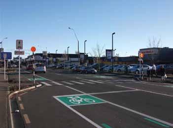
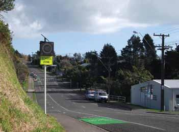
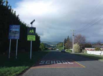
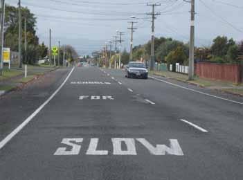

Figure 7: School Bus Route sign (near Ngaruawahia, NZ)
Figure 9: Entering the school zone (Clive, NZ)
Figure 11: Swing-out School Patrol STOP Signs (Clive, NZ) Figure 8: Vehicle queue at afternoon dismissal (Tauriko, NZ)
Figure 10: At the school crosswalk (Clive, NZ)
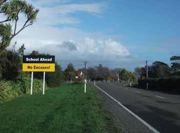
Figure 12: Oversized sign (Opiki, NZ)
