“Nothing in this world is more simple and more cheap than making cities that provide better for people.”
Jan Quel
My Contact
ar.venkatchandran @gmail.com,
2023mud018@spab ac in Sivaganga,Tamilnadu630556 8838005758
Hard Skill
Site Supervising
Client Meeting & Handling
Procurement
Extra Curricular
Sports(Cricket, Football)
Reading Books
Interested in Ecology (Agriculture)
VENKATESH WARAN
ARCHITECT - URBAN DESIGNER
About Me Professional Experience
Hard-working and focused university graduate with a Masters of Urban Design from School of Planning and Architecture,Bhopal. With 1 years of study, have gained knowledge of design and planning disciplines, including architecture. Looking to apply my knowledge and enthusiasm to the graduate urban design role at your Reputed company. Expert Architect bringing 3 years of expertise in Architecture Industry. Effectively manages assignments and team members. Dedicated to selfdevelopment to provide expectation-exceeding service.
Education Background
Mohammed Sathak Engineering College,Ramanathapuram,Tamilnadu.
Batchelors in Architecture
Completed in 2020
School of Planning and Architecture,Bhopal,MP
Masters in Urban Design
Complete by 2025
ADOBE PHOTOSHOP
SITE PLANNING AND DESIGN EXPERT
3D MODELLING
VECTORWORKS
ADOBE INDESIGN
Al Afaq International Contracting Company,Kuwait
Sep 2022 - Sep 2023
Key responsibilities:
Coordinated project team in development of preliminary and final design documents.
Confirmed construction against drawings and designs with team of builders, maintaining quality standards.
Coordinated review of contractors schedules and submission of shop drawings and samples.
Specialised in softwares like Autocad, Sketchup, Photoshop, Vray, Lumion, Illustrator, Indesign, Revit.
Coordinated review of contractors schedules and submission of shop drawings and samples
Leo Associates,Anna nagar,Chennai.
Jan 2022 – July 2022
Firm with builder and promoter (mainly apartments and commercial complexes)
Key responsibilities:
Oversaw projects from concept through to delivery.
Worked within Sketchup & Autocadd to complete designs, model renderings and specification details
Created professional, to-scale sketches to communicate and clarify special requirements
The Grandeur Design,Coimbatore.
Oct 2020 – May 2021
Firm run by Young Architect cum Interior Designer (Mainly Interior Projects (Residential & Commercial),Resorts & Hotels
Key responsibilities:
A Good start experience with Residential,Commercial interior & Exterior with proper site executions
Produced designs and drafts of project blueprints
Worked within Autocadd, Sketchup, Photoshop, Illustrator, Vray, Lumion to complete designs, model renderings and specification details.
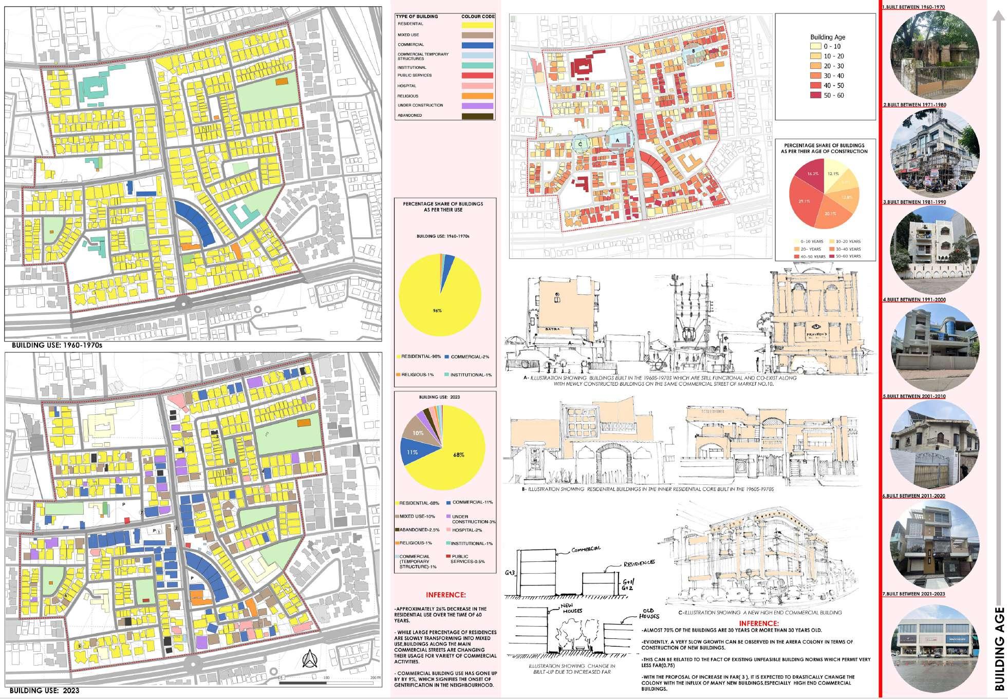
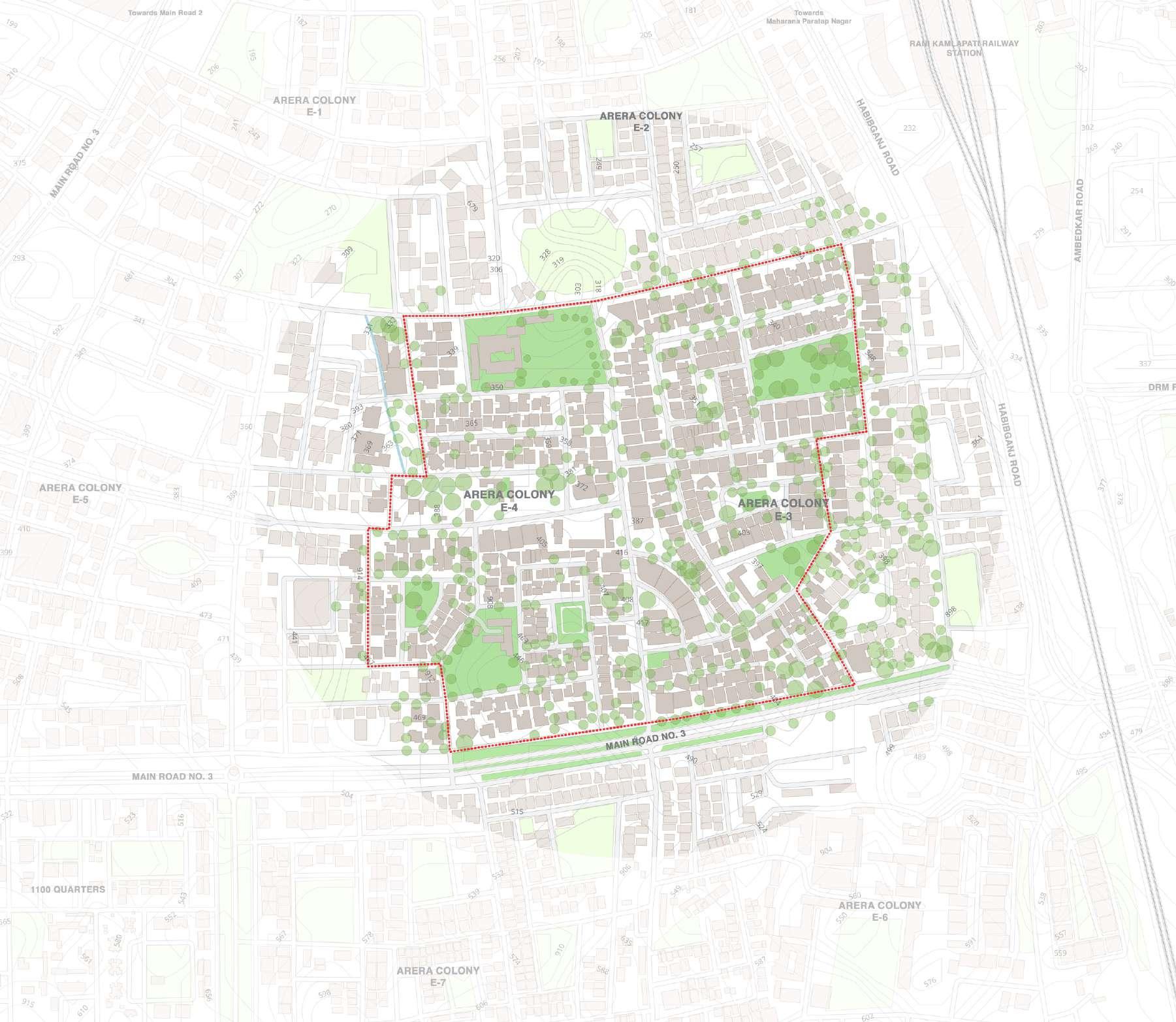
ARERA COLONY, Bhopal - Introduction & Building Use
ARERA COLONY being the older colony in Bhopal established by local residents in 1960's is one of the well planned and developed Gated Neighborhood community Areas starting from E1 now its developed until E7 due to its overcrowding population in its neighborhood level It has Rani Kamala pathi Railway station with half kilometer and also main Hosangabad road on its edge, and also has dense vegetation creates a good vibe of Self sustaining and peaceful Neighborhood environment
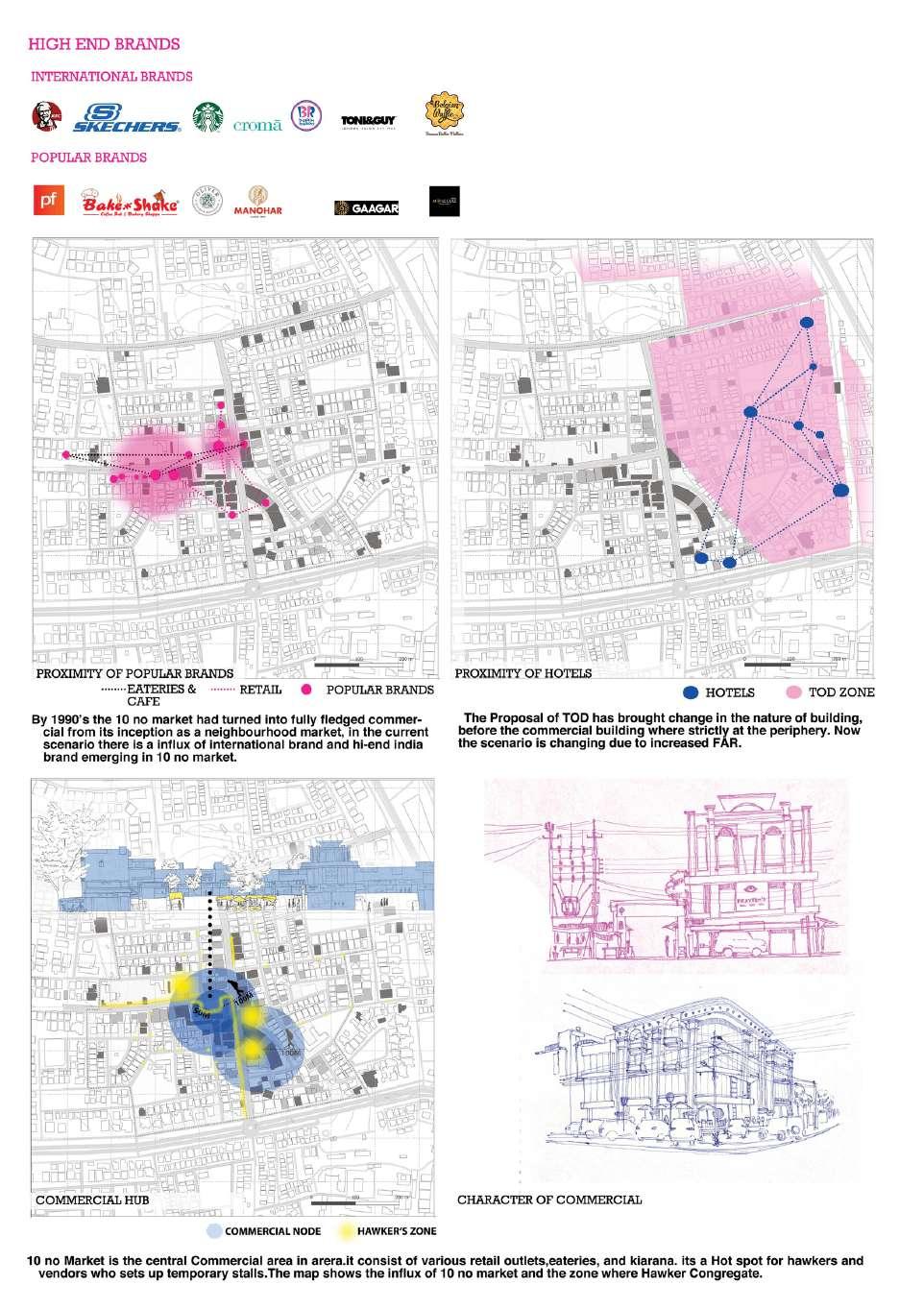
But due to its commercial penetration inside the Residential areas Arera colony lost its essence of neighborhood day-by-day Presence of 10 No Market in Arera Colony ( One of the Oldest City level Market in Bhopal ), attracts people from all over the city results in overcrowding & Traffic and a major threat to Residential Nature of the area.
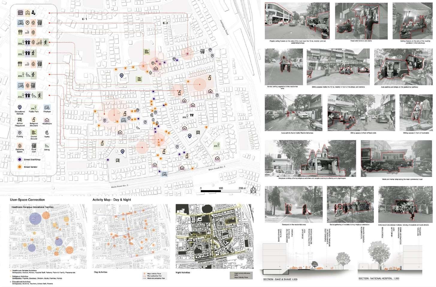
ARERA COLONY - Activity Map & Building Age
Arera colony we are given with E3 & E4 Zones where 10 No. Market is present, Market makes the area to complicated for several activities and affecting the neighborhood Residential environment also
Activities like Formal Commercials, Informal Vending Carts and Temporary Shelters, On street parkings, Spatial activities like institution, temples, parks, Hospitals keeps the area more active in Day time
At night Majorly commercial Activities are found on the National Hospital road and the KFC roads
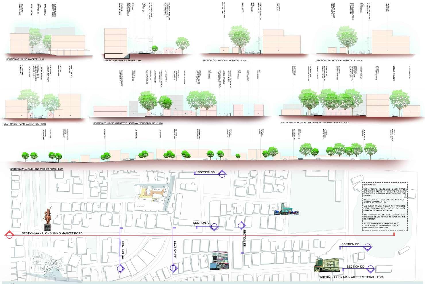
ARERA COLONY - Commercial Typology & Sections
Arera colony have lot of commercial influences, so we can find both local commercial brands to International Brands like KFC, Starbucks, Skechers, Croma Also local well known brands like Bake n Shake, Manohar Bakery And also well known Hospitals like National Hospital, Bhopal Fracture Hospital, etc
Colony have road widths starting from 12 Mts to 5 Mts Wide roads, where lots of encroachments can be seen in these sections by street vendors On street Parking are everywhere, Pedestrian pathways are complete, even if it is there, those were encroached by the shop keepers for their advertisement boards, display boards for showcasing their products
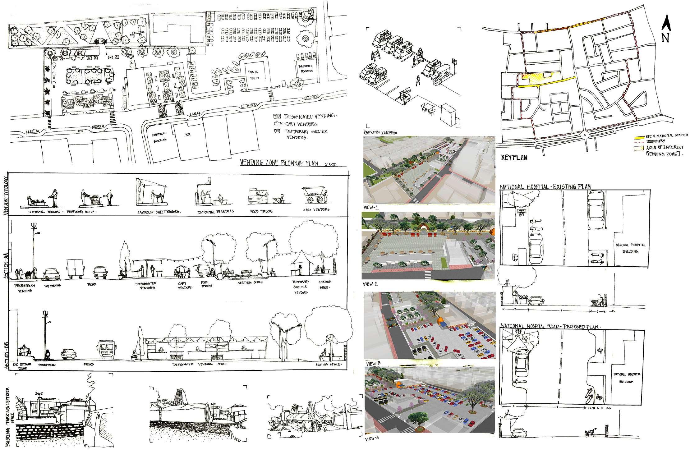
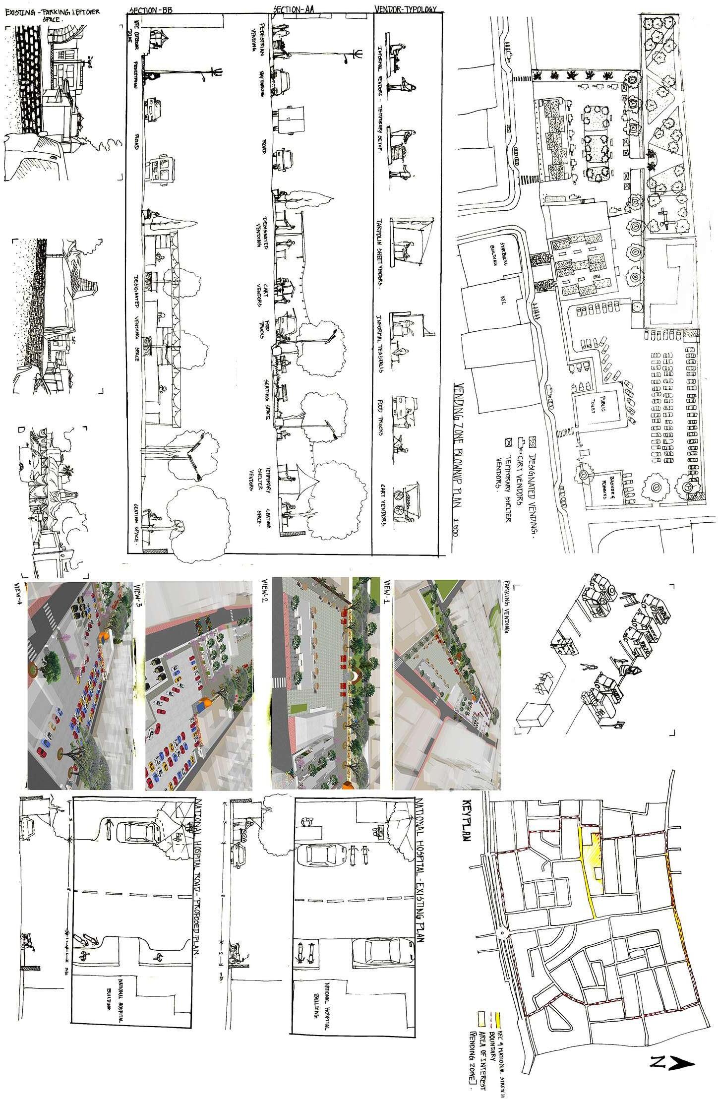
INTERVENTIONS - Proper space for informal vending to protect arera colony character, and also to boost the local economy.
Pathways are widened by
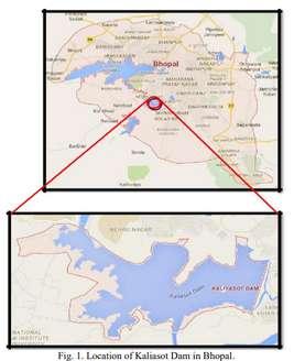
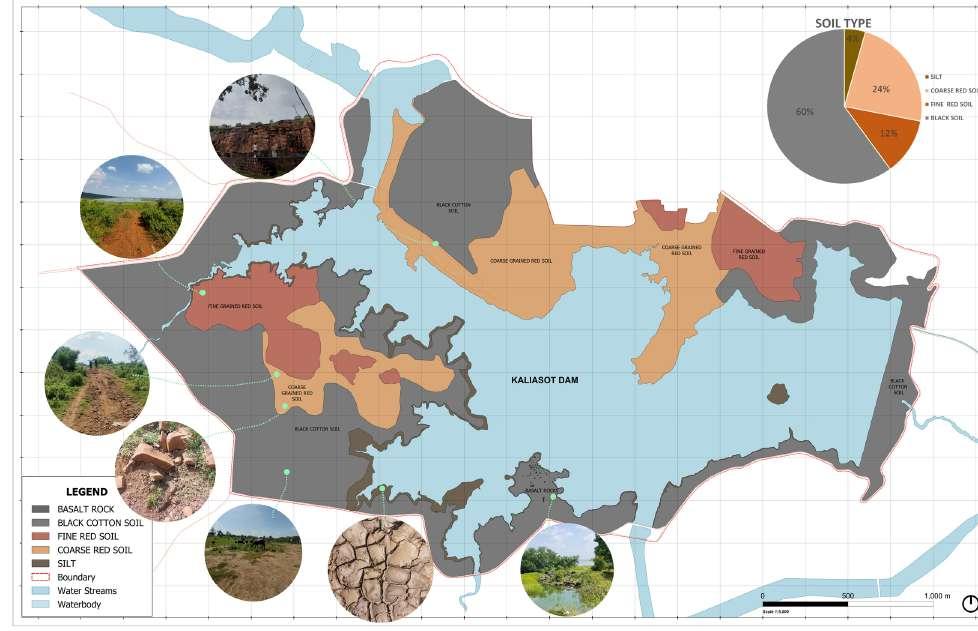
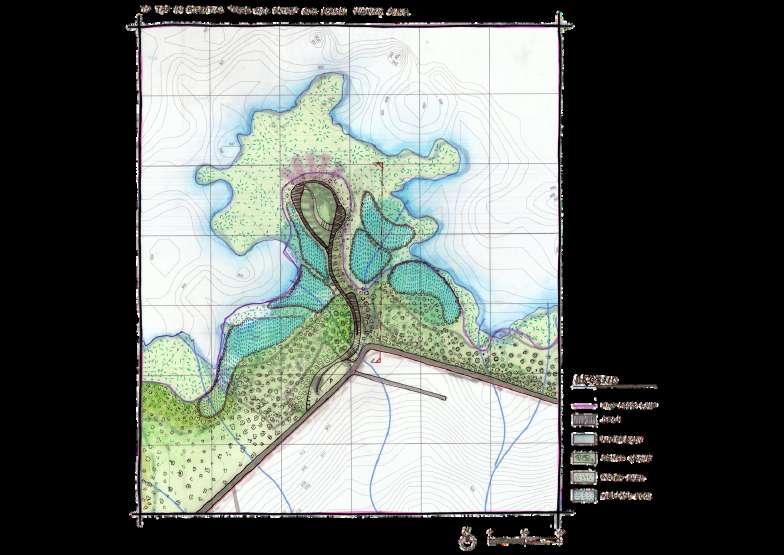
DAM, Bhopal - Introduction
Kaliyasot Dam, being, a significant source of water supply, it is one of the important feature of the city It is basically a storage reservoir, near Chuna Bhatti Village, of the Kaliasot River which is a tributary of river Betwa This dam was initially constructed for irrigational purposes and it still serves as the second source of water supply for 10,425 hectare agricultural land of Bhopal as well as Raisen district of the state Its hindmost site is the downstream of the Bhadbhada spill gates of the Upper Lake The dam has derived its name from the name of KalyanStrote, the one of the minister of Raja Bhoj, who had developed spillway of Upper Lake
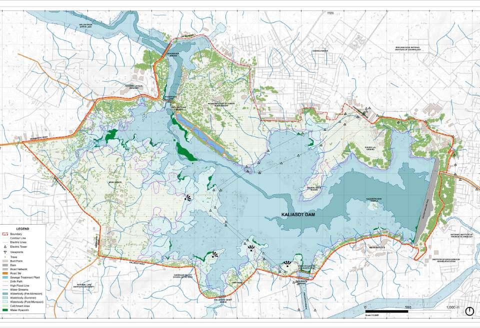
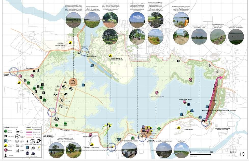
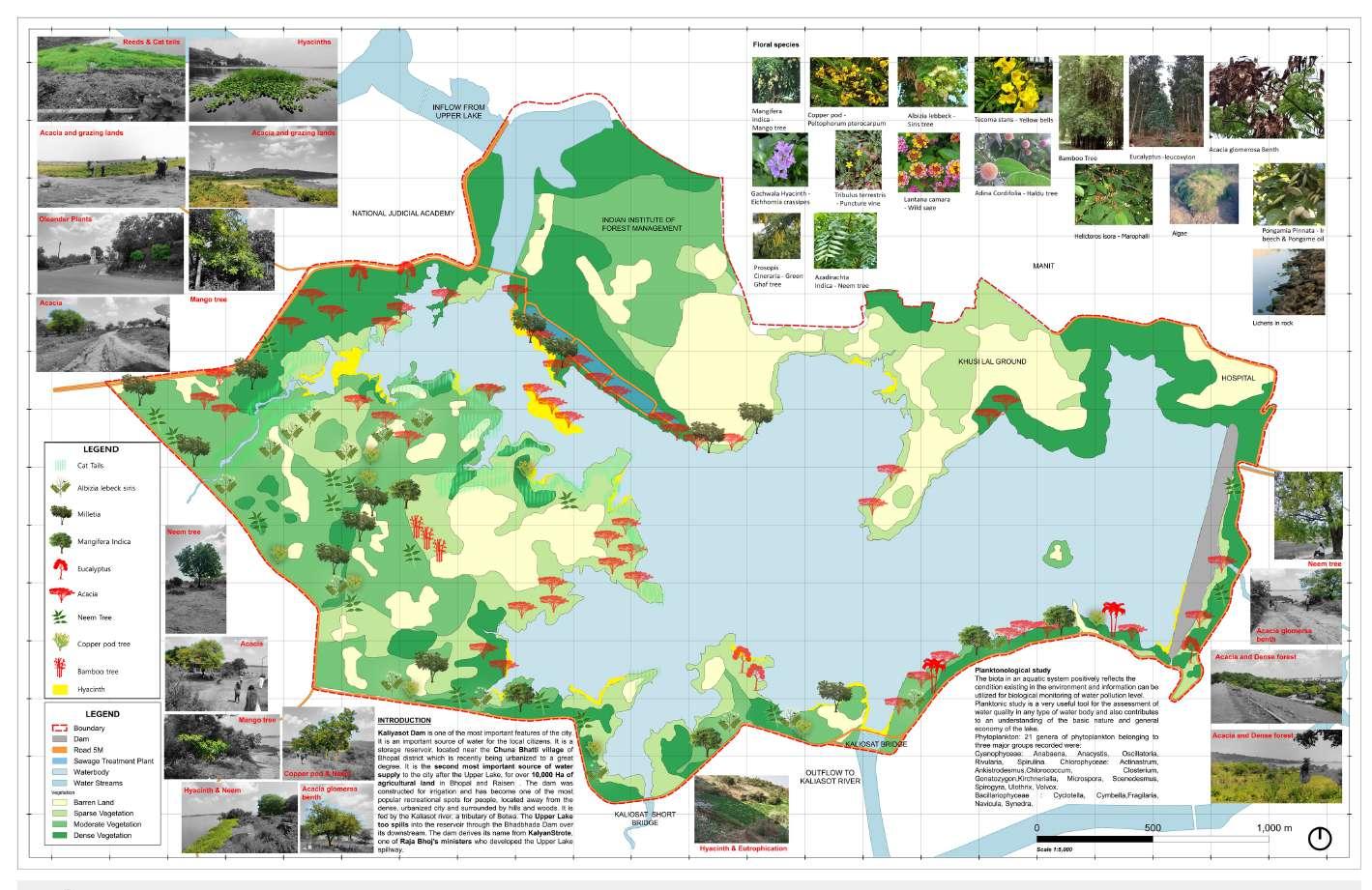
Activity Mapping - Kaliyasot Dam width approx 4 Km stretch, covering lot of Formal activities & Informal Activities like viserjan (Ganapathi Pooja), Temples, Dairy Farms, Nursery Farms, Cattle Grazing , Kite fly by Locals, Boating, Fishing, Restaurants & Cemetries , also Squatters can be found
Flora Mapping - Kaliyasot Dam have both Dense & Sparse tree patches, Since Bhopal is rich in ecology, it has several variety of flora species which includes Neem, Milletia, Copper pods, Eucalyptus, Acacias, Bamboo, Mangifera Indica, Albizia lebeck siris, Cat tail(Reed) etc.
Apart from those we also found Water Hyacinths a particular Aquatic Plant which can be found only in polluted waters ( the more hyacinths the more water is polluted).
Soil Mapping - Kaliyasot is a Catchment Dam from upper lake Bhopal, on its way it collects lots silts over it we can fine grained red soil. Kaliyasot was predominantly covered by lots of Black Cotton soil which are rich in Nutrients and Minerals so that it enrichess the vegetation well.
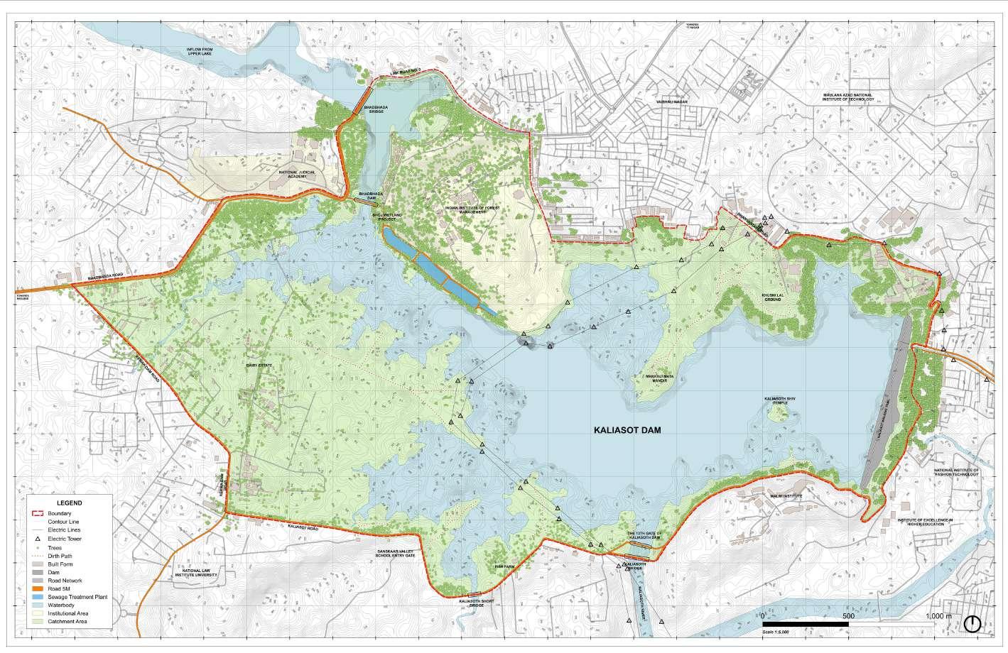
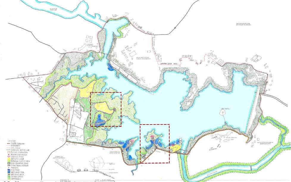
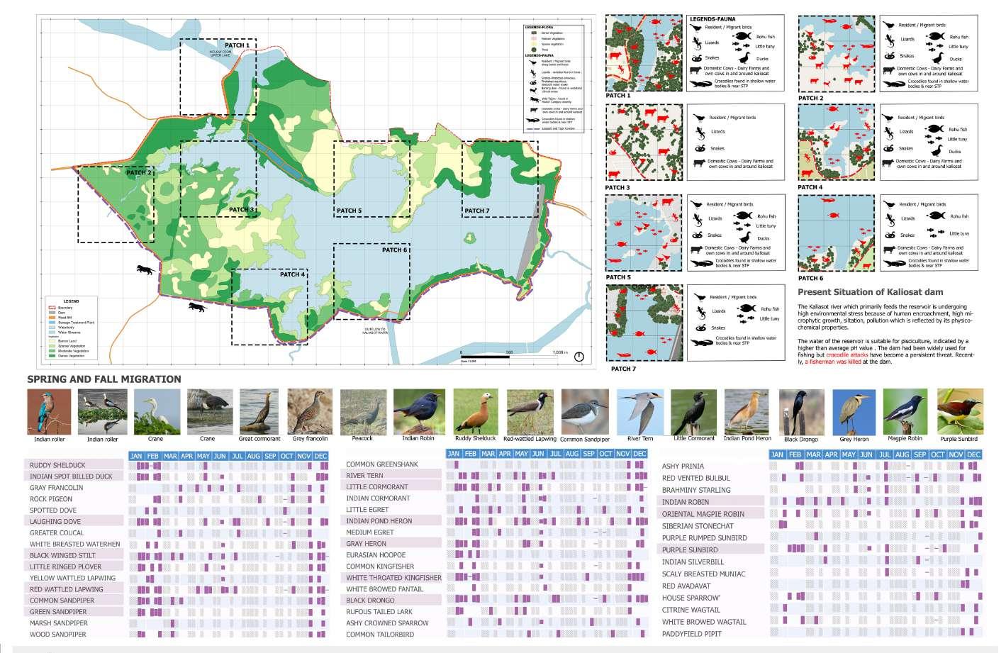
KALIYASOT DAM - Fauna Mapping & Interventions
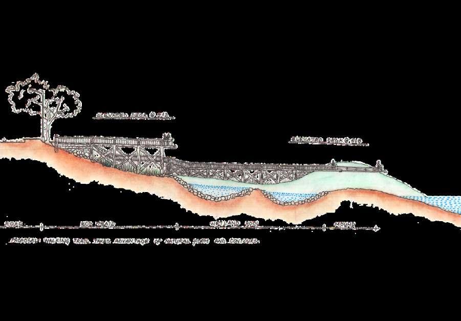
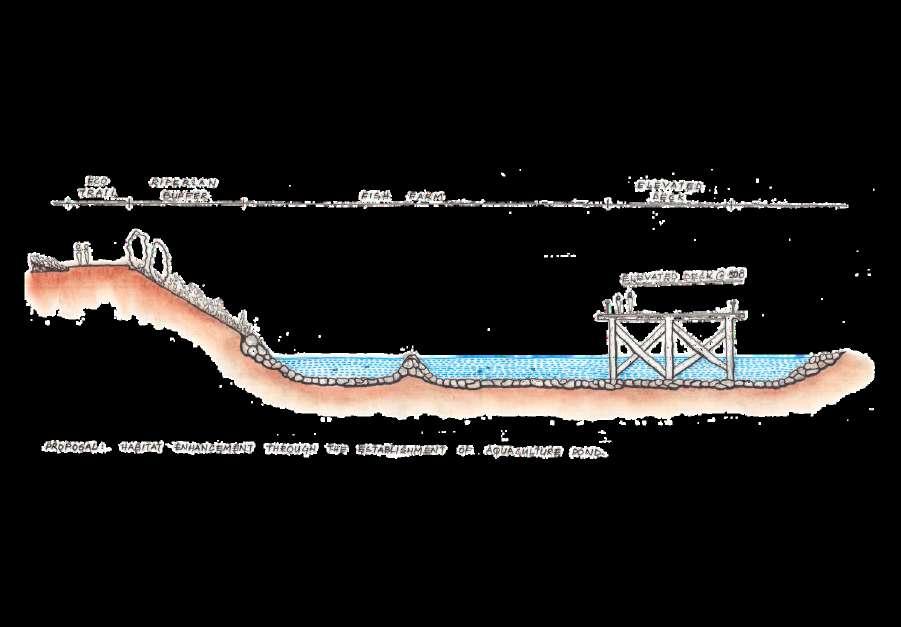
Intervention - Kaliyasot Dam has lot of encroachments, so we decided to clear those squatters and other illegal dirt paths(which leads to dumping of dust in dam) as well as we decided to facilitate the day to day activities by locals like walking, jogging- we provided eco trails for them, we limited the access of the catchment area by giving natural fencing (Ha Ha Wall ) to avoid unwanted exploitations.
Fauna Mapping - Kaliyasot Dam have lot of Faunas which include foreign migratory birds and local species In fishes Rohu, Little Tuny Fishes can be found predominantly In animals Tigers, Foxes, Leopards, Buffalos, Cows etc Total 13 Crocodiles can be found in and around the Dam, also have 3 human conflicts over the years.
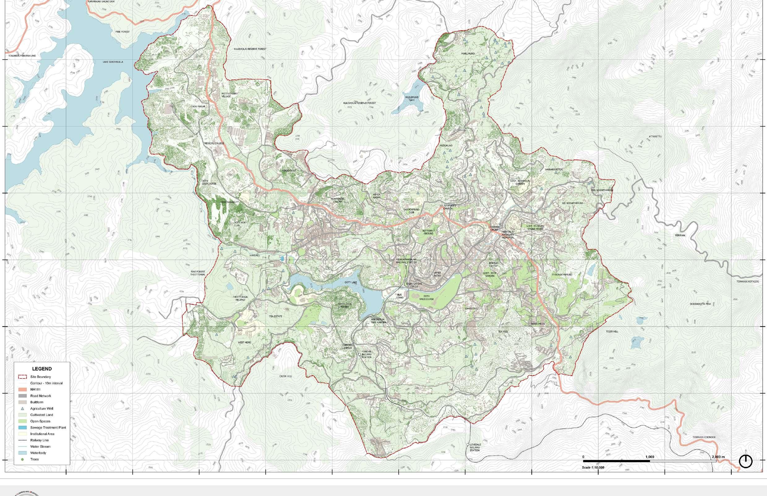
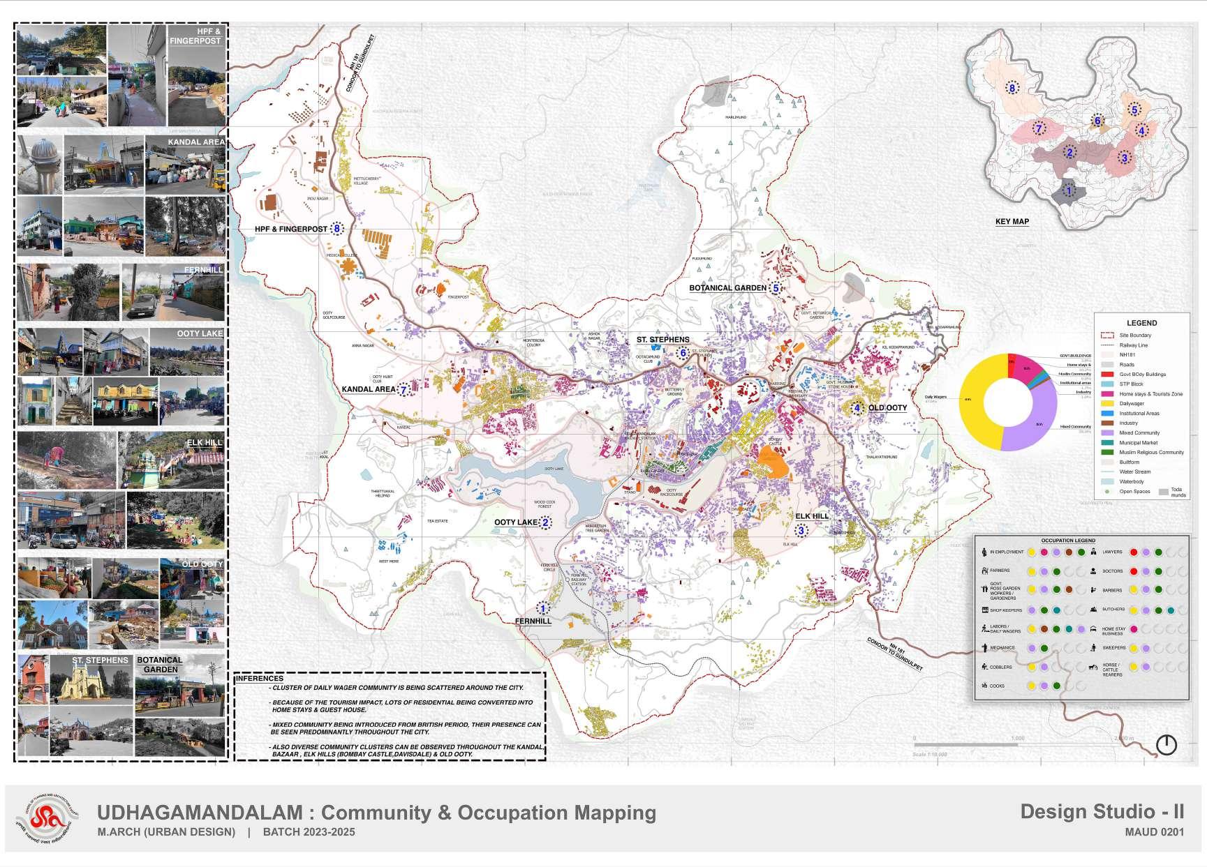
OOTY - Introduction (Base Map)
OOTACAMUND - INTRODUCTION:
Ooty is a charming hill station lying in the Nilgiri District of Tamil Nadu state. The city is set amidst four beautiful Nilgiri ranges viz Snowdon, Elk Hill, Doddabetta and Club Hills Precisely, Ooty is situated at a place where Western Ghats conjoin Eastern Ghats Ooty is located at a height of 2240 meters above sea level
The popular hill station Ooty is a shorter derivation from its original name Udhagamandalam, sometimes called Ootacamund During earlier times it was also called OttaikalMandu The charm and beauty of this hill station in Nilgiri hills calls for the name it got, ‘The Queen of Hill Stations’.
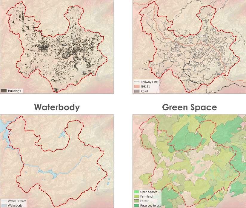
ROAD NETWORKS
FIGURE GROUND
WATER BODY
GREEN SPACES
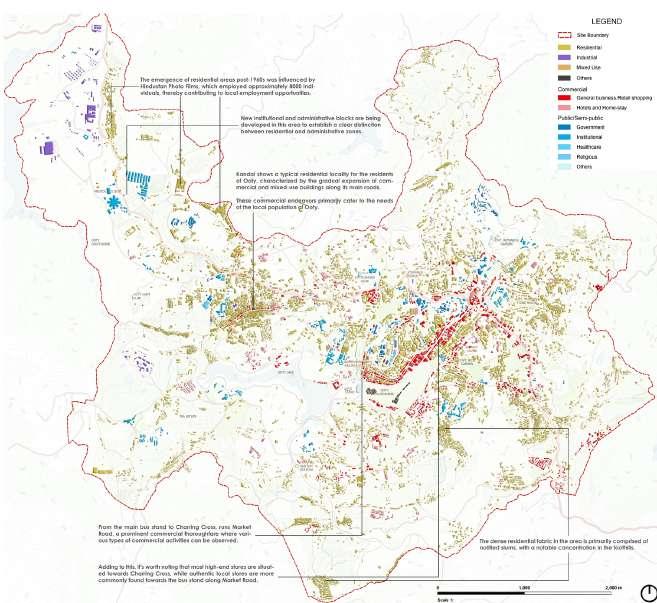
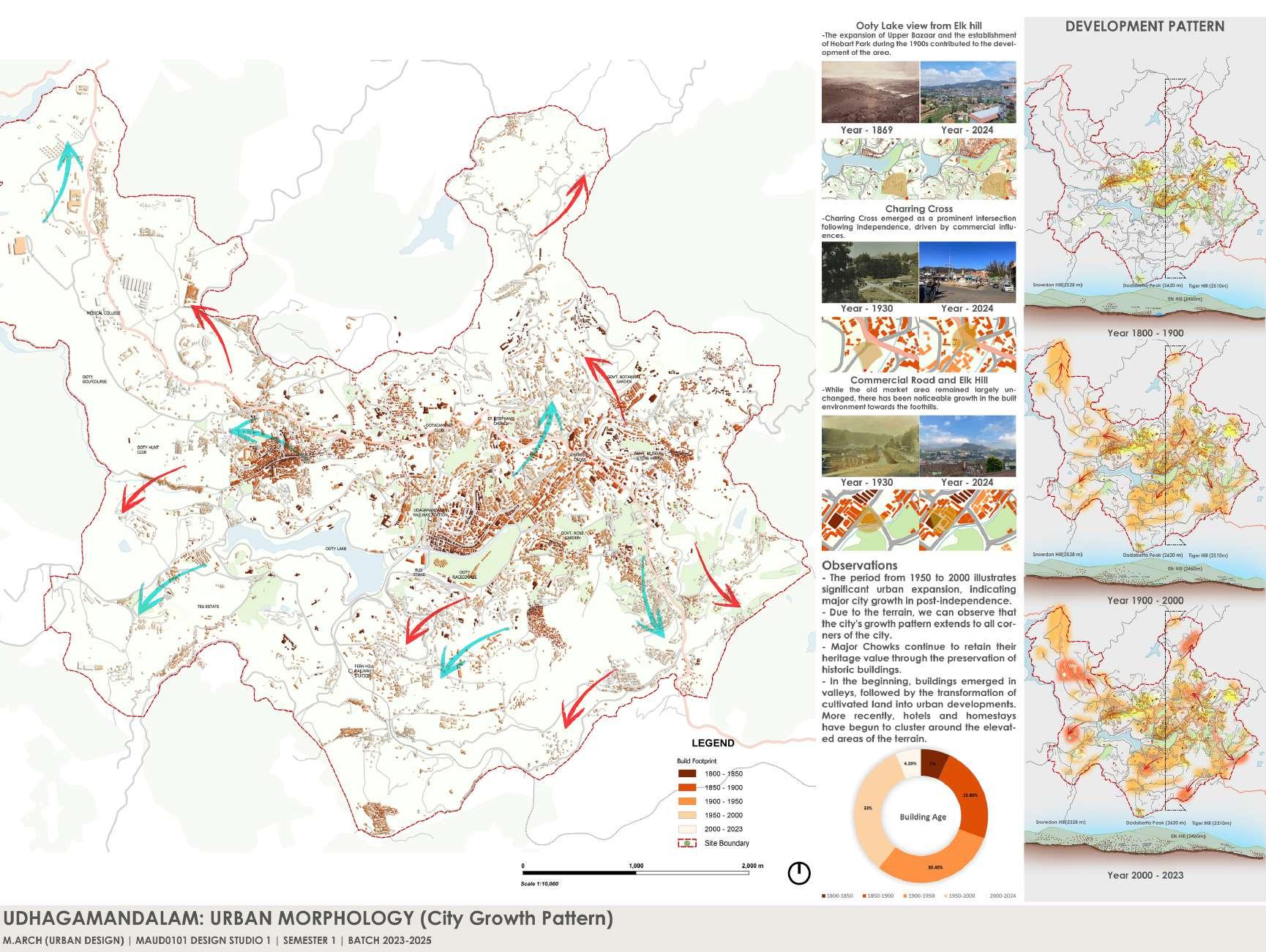
OOTY - Landuse map & City Growth Map
CITY GROWTH MAPPING - OOTY Being the old hill town developed by Britishers, started near to the botanical garden side and Stone house in old Ooty, now it is changing its development towards the HPF & Fingerpost in NW Direction of the city
As per chronological order the city is facing densified and growth more after post independence, after Britishers
In the beginning the settlements are in the valley areas starting from old ooty to Kandal area, but later in the British period those slums are settled over the elk hills and in the Fingerposts, Fernhill sides only
Now due to Tourist Inflow & Outflow inside the city core, Heavy traffic and threatens to their day to day livelihoods, locals prefer to move outside the city in all directions, especially towards NW & SW Outskirts of the city
OOTY - Landuse map & Community Map
COMMUNITY MAPPING - OOTY have primary community as Tribals only before Britishers, later on after the Britishers invasion several outbreak happen and Britishers brought lot of outsiders as a serving community for their govt & the low class jobs like (Doby, Barbers, Horse-rearers, Gardeners, Butchers)
And later Muslim & Christian community came to the city for commodity purpose and started to settle all over the city, this caused the Native tribal people to move outside of the city itself.
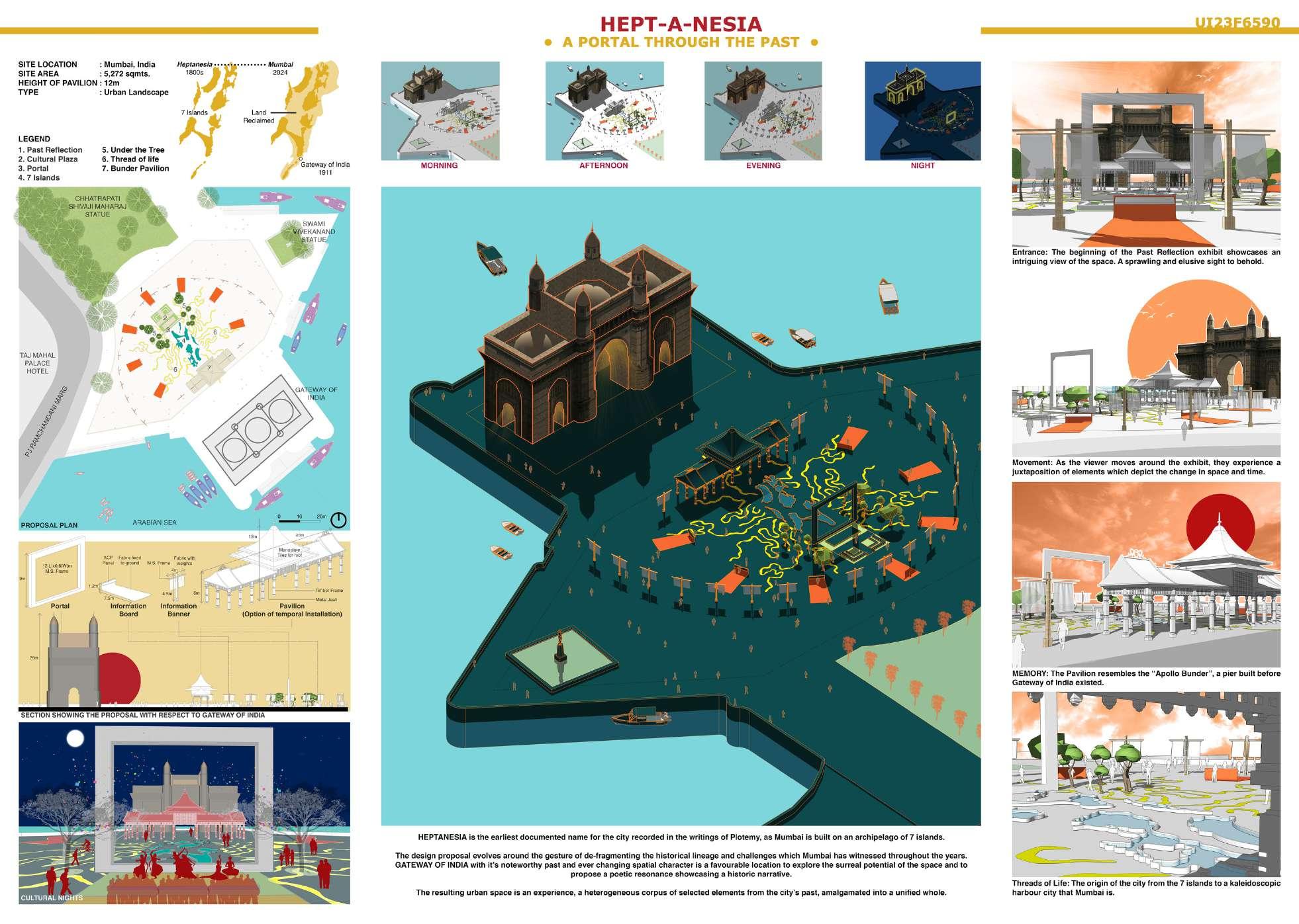
URBAN INSERT - Archmello Competition
The challenge is to design a meaningful insert at the Gateway of India , Mumbai. With hundreds of visitors everyday from within the country and outside, the Gateway of India acts as a large public gathering space.
The insert can be fully covered , semicovered or open as per participants design proposal. Participants can use any material of their choice.
The insert can be permanent or temporary.
The installation should not exceed the height of 12 MTS. Entire site can be used for designing but any built structure ,insert, installation should not exceed 1200 SQ MTS
*Basements or any kind of minor levels below ground level are not allowed Anything you propose should be above ground level only Brief
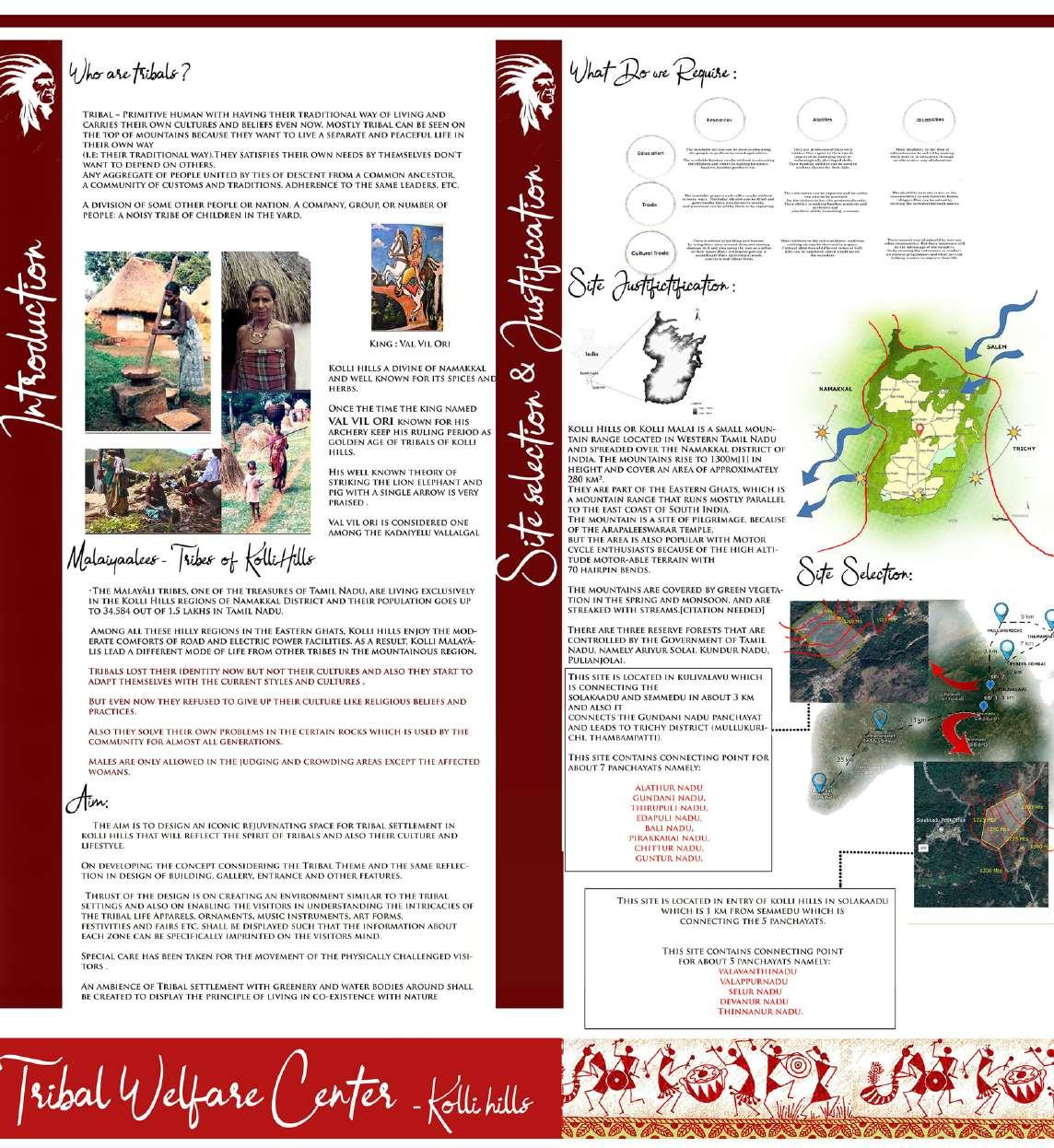
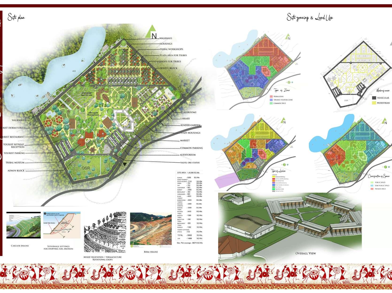
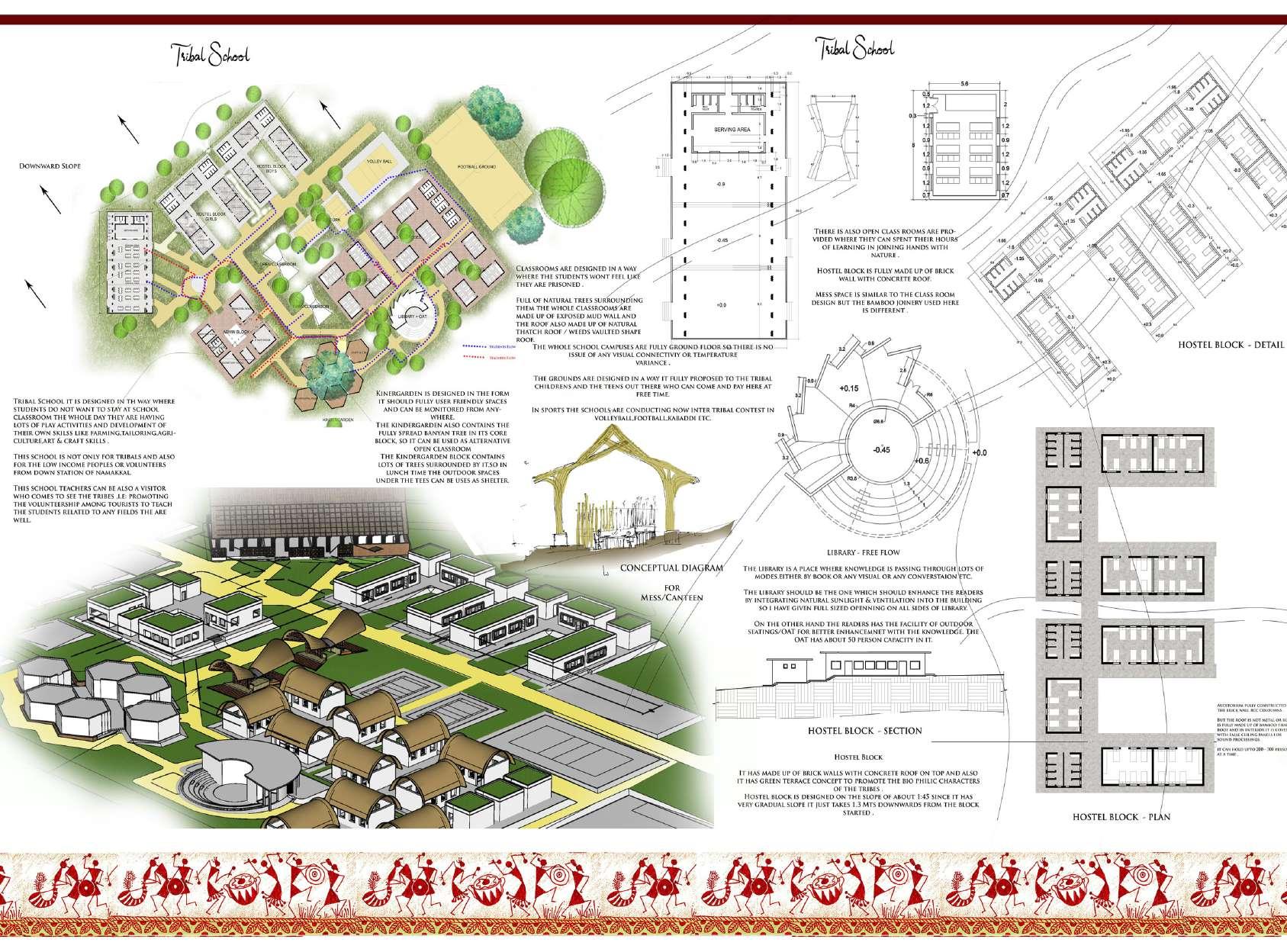
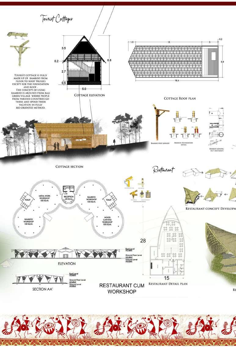
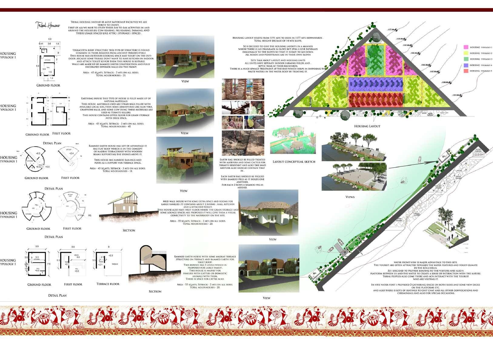
TRIBAL WELFARE CENTER - Kolli Hills, Tamilnadu(Architectural
My Architecture Thesis was “TRIBAL WELFARE CENTER” where I’m focused for certain tribal community (Malayalee - People live over mountains ) in kolli hills, Namakkal District.
I want to do a thesis project about their livelihood and making their inability to communicate with outsiders, So i decide to facilitate a common space where outsiders and tribals will have a chance to meet and share their knowledge to each others, and in the final it results in a Welfare Center, near to the Tribal Village itself
My major concern is to facilitate the tribal communities by providing basic infrastructure like housing, Schools, a arts and craft center as a knowledge sharing center, and at last a tribal market for tourists