
Karl Rösler CreatingFutureStreetsChairforArchitecturalInformaticsDepartmentofArchitectureTechnichalUniversityofMunich

Creating future streets Chair of Architectural Informatics Prof. Dr.-Ing. Frank Petzold sustainable spaces | shared futures Nick Förster, Ivan Bratoev, Sarah Jenny Karl 03726221Rösler
45434139251511731 ContactFeedbakOutlookDiscussionFinalPrototypingConceptIdeationResearchIntroductionImplementation Table of Contents
Even before I started the course, I was already interested in the topic of street space in a meaningful way. A few years ago, I sold my car because I realized that you can easily get around in the city using public transportation, bicycles, or sharing services. Especially now during Corona, the topic of PopUp bike lanes came up in Munich, which certainly had many supporters but also opponents. This was most noticeable when the bike lanes were abolished again, although they increased the safety of cyclists a However,lot.
If you study it in detail at the present time, it quickly becomes obvious that the streets are completely overloaded and none of the road users can feel safe. The picture is characterized by traffic jams, construction sites and an immense number of parked cars. Especially the last aspect is a very significant one, because 95% of the time a car is parked in the city and this takes up an enormous amount of space, which could be used much more sensibly and made more accessible to the public. Since many of the citizens lack a vision of what could change, I would like to focus on making the potential of our streets and future means of transportation more accessible.
1 Introduction
it did show the long necessary debate, from my point of view, how our future urban space will look like.
2 https://www.tz.de/muenchen/stadt/muenchen-pop-up-radwege-temporaer-routen-gefahren-risiken-adfc-warnung-13807674.html © Marcus Schlaf

Thereprocess.are already various forms of citizen participation, but Corona in particular shows the limits of these processes. Although procedures with personal contact are inevitable, a basic system is needed that is accessible to every citizen at any time.
Some cities around the world have already reacted to this and have either severely restricted or completely banned the use of cars in the city center. But how does this work and what does it take?
Research CarFreeCities//Participation
3
CarFreeCities are certainly far from being a novelty, because our old cities were built when cars hadn‘t even been invented yet. Intended to get from A to B quickly, cars today tend to cause long traffic jams, exhaust fumes, accidents and, above all, a loss of public space.
First and foremost, it takes political restriction. If this is given, there are 2 ways to reduce and then completely ban individual traffic.
The radical variant is certainly to define an entire urban area that can only be entered by car in exceptional cases. In order to be able to enforce this, however, an already welldeveloped, holistic public transport system is needed. Since this is often not the case, there are soft measures that encourage people to get out of the habit of driving. These include reducing parking spaces, closing traffic arteries, speed restrictions, etc. Participation plays an important role in this entire process. Even if the basic regulation of the streets is decided politically and through planning, new urban space is created that can be used. Citizens must have the right to participate in this design
4
https://weburbanist.com/2015/12/21/car-free-cities-12-pedestrian-only-places-from-venice-to-nyc/

5 https://www.researchgate.net/figure/effects-for-people-changing-from-car-to-active-transportation-and-the-generalpopulation_tbl1_303814646
Starting with the change of the urban structure it will influence the behavior of its inhabitants. Through the use of more active means of transport, it will lead on the one hand to climatic improvements and on the other hand to physical and mental strengths on a personal level. Ultimately, this measure achieves a strengthening of society and public space at all levels.
This graphic explains the impact of the change without individual traffic on different scales.

Consul is one of the pioneer projects on the market of urban space design participation. It is a free software that can be used by the respective city. The software was developed for the transformation of Madrid and had great success there. The special feature of the program is that the participant can not only evaluate and comment on ideas or measures, but he also has the opportunity to generate his own ideas. If these ideas meet with the approval of other participants, they are supported and pursued further.
6
https://consulproject.nl/en/#documentation


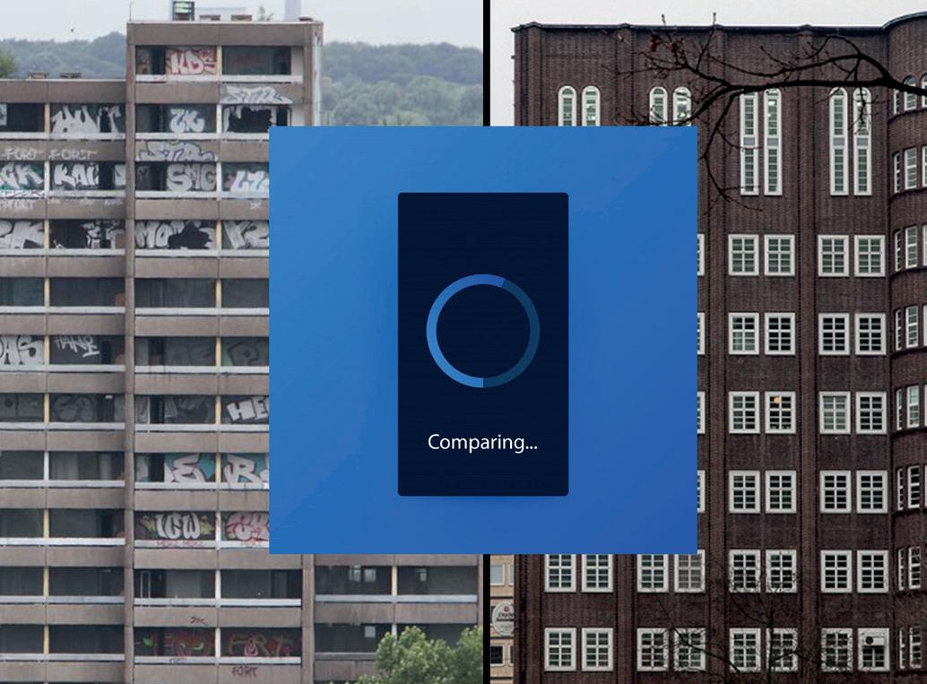
As already mentioned, the basic idea was to generate the vision of the future street. To do this, however, it was first necessary to take a close look at the current situation. Where are there complaints? What is good? What has potential? Does something have to change drastically? The contribution of ‚Green City‘ certainly helped to answer some of these questions. Here are the biggest issues that are inevitable to improve: Durability of urban space, safety, sustainability of environmental factors such as exhaust fumes and noise, social spatial design and finally the efficient use of space. As you can see in the picture collage on the right, our current road space is far from being efficiently utilized. The number of individually used means of transport is overwhelming the possibility of using much more economical transport solutions. This leads to a daily conflict of cars, buses, trains, bicyclists and pedestrians. The danger of accidents and a high stress level is pre-programmed. The biggest shortcoming is probably the lack of a guiding idea from politics. It is easy to imagine how there was a clear attitude towards the city with cars at that time. But today there is a controversial discussion of car lovers and FridaysForFuture supporters from which it is very difficult to see a compatible and common path. This may unsettle the broad society rather than positioning it clearly. Therefore, I think it would be a smart way to offer everyone the opportunity to create their own desired road and thus generate an overview. Based on this, I developed two storyboards. The first one is related to the main idea. The second an independent concept from these thoughts to stay open minded.
Ideation
7
https://www.researchgate.net/figure/Amount-of-space-required-to-transport-60-of-people-by-bicycle-car-and-bus_fig23_312588628 8


9 Storyboard 1 StreetscapeVision 1 2 3
The main element of the first storyboard was to offer a large touch displays in a famous public spaces. Through these, the citizen has the possibility to get information about the visionary road-network. It should give the viewer a sneak peak of what our street could look like in the worst and best case. In the end, this is done via VR on the user‘s own smartphone. So while you can move around, you can compare the current situation with the situation in maybe 15 years.


10 A very different problem is that planners don‘t have access to urban mines and information on existing buildings in general, but in the future it will become increasingly important to consider the existing building stock as the first solution for new projects. One solution could be to use a drone to analyze the buildings for desired factors (insulation properties, materials, etc..). Then a 3D model would be created containing this information and there would be a freely accessible platform for all planners. Storyboard 2 UrbanMiningMapping 1 2 3


The counterexample is obviously a tool that allows the citizen to design the street space according to his preferences and then find a great compromise for all. As a planner who has studied for many years, I naturally believe that expertise is more reliable than an endless wish list from citizens, which may be too imprecise and arbitrary. For the time being, I focused on a plug-in that would help the planner to analyze changes to roads. As it turned out later in the prototype phase, this concept sounded easier to realize than it actually is. In the following pages I will explain my two concepts quiet short but in more detail.
Some or all together?!
With this basic idea, however, the question arose who is actually suitable to design the street space and is it necessary to analyze it precisely in order not to act rashly?!
Concept
After a survey in my immediate vicinity, most people thought it would be more plausible if planners used a suitable simulation tool to create a coherent design and citizens could make small changes later on.
11
12 ToolPlannerSimulationvs.ParticipationTool
The concept of the simulation tool should be as follows: The planner has access to a 2D or 3D city map on his computer and gets the order to change certain streets. He would then develop a concept and enter his desired changes via the plug-in. A simulation would run in the background and give the planner feedback on how his changes would affect the rest of the adjacent traffic network. This would make it easier for him to make decisions.
13
ToolPlannerSimulation


14
ToolParticipation
The basis of the participation tool is also a city map in 3D, which is stored on a server. This virtual 3D model represents the real situation. The planner then also examines the streets to be changed and provides a catalog of possible measures and feeds them into the server. The citizen then has access to this information and measures and can implement his ideas in the 3D model. The planner can then use these ideas, which have been generated numerous times, to create realistic designs that reflect the broad picture of the participants as far as possible.


One-waysimulation:streets,
15
This(fig.4).already shows the complexity of the entire concept and was ultimately one of the reasons why I chose the participation
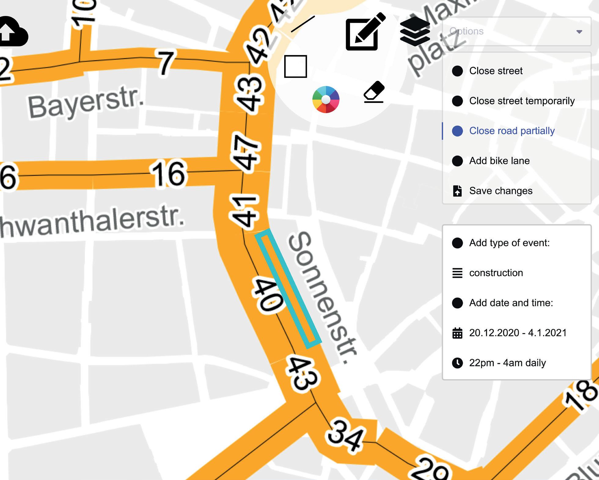
To capture these conceptual thoughts I generated a prototype to both variants. The first prototype to be seen is the simulation tool. From the concept further developed the idea came up to use the tool to decide for which roads it makes sense to close them permanently for individual traffic. At the same time, it should also imply other features, such as temporary closures. Here is an overview of the indicators that would play a role in the street width, number of lanes, condition, number of vehicles per hour, traffic lights, accessibility to public transport, etc...
Prototyping
The output of this is illustrated quite clearly on page 17 via four screenshots. First, you already have a street overview of the city, where you can read off the amount of usage by the displayed width of the streets (fig.1). If you now enter and select a street, you get more general information but also hints on planned measures (Fig.2). In the upper corner of the tool you have several options to choose what you want to change on the street (fig.3). Selecting one of these tabs opens an editing tool where you can draw the zone you want to change and also enter further information about the type and duration of the event. If you save the changes, the tool analyzes the street space and can give hints
SimulationPlannertool.Tool
16
17 1 2 3 4


Chair of Architectural Informatics Start Rhino Select file path Open documentnewRead with ELK Plug-In Bake needed roads to Rhino PlugNewIn GrasshopperStart Read data list ReadFasteststreetsroutefromAtoBPoint A Point B Show traffic by line otherShiftthicknesstraffictoroadsifchanges Bake result Interactivemenu Filter street types (a,b,c,…)OSMfileExcel file about street datatraffic,..)(lanes, End Streets in Rhino DeletestreetoneNewstreets in Rhino Upload to website participationfor Set up (implemented in Rhino) Set (implementedupinGrasshopper) (implementedVisualizationinRhino) (implementedTool in Grasshopper + C# scripts in VS) Export datatree 18
Related to page 21 - 23 i will explain what I have now focused on. The start interface consists of a classic 2D map showing the city (fig.1). When you search for or select a street, you switch to 3D view and a pop up window opens while the street remains highlighted. The graphic should explain which measures the other participants have voted for (fig.2). To the right of it, there are three buttons that can be used to open other windows, as well as an info icon. If you select the info icon, you will see a detailed list of the exact measures (fig.3). If you press the Climate button, the change in various climate factors will be displayed according to the average selected measures (fig.4). Via the chat you have the possibility to exchange information between citizens, planners and politicians about various topics or to clarify open questions (fig.5).
After the last prototype, I was reading a lot about case studies on carfree cities. Thereby I became more aware of the fact that a simulation of a longterm road closure would be far away from real results and therefore not very meaningful. Whether a street is closed or not can only be decided by discourse and political decisions.
ParticipationToolPrototyping
19
Tool
If you finally select the Participate button, you will get to another view. Here you will find the same measures as seen before. These can now be selected and objects of this category appear, which can now be added to the 3D model (fig.6). Once you have browsed through all the topics and their related objects, you can design your streets as desired (fig.7).
20

21 1 2 4 5


22 63


23 7

24

25
Final Implementation
For the final concept, I assumed that it is already politically proposed which streets will be closed for individual traffic and designed a participation website to recreate these empty street Basically,scapes.this prototype does not deviate from the previous version in terms of the idea, but there were some points that needed improvement. I would like to go into these aspects in advance and this time explain the prototype in detail using the individual graphics on the next pages.
First of all, I decided to change the device usage to computers, because you can work more precisely. In general the previous version lacked a clear focus. The question came up, what exactly do I want to achieve and who is my target group? Is it a serious participation tool?! Is it purely informative for an overview of all measures?! Or do I want to achieve a learning effect and thus encourage many people to rethink?! In the end, I tried to combine all these aspects in the final version by developing different phases. The main task, however, was to make the participation part more plausible. Part of the issue was that the catalog of measures was too diverse and confusing for a single street. So, as already explained in the concept, from here on a certain selection of measures will be pre-determined by the planner. This is because each street has its own potentiales and weaknesses. This last point concerns even a street itself. Different sections may need different measures, which is why I decided to divide streets in smaller segments.
26

27 When you enter the website, you get to a classic map view on which an area is marked that is to be free of individual traffic in the future. It was important to me to design the interface in a simple and natural way at first sight.

If you now zoom into the map or search for a specific street using the search function, the map is built up in more detail. You can now see that different streets have different colored markings. This helps both planners and citizens to keep an overview. If you want to get more detailed information, you can select the legend on the upper left side.
28

Yellow streets already have a clear planning result, but there is still the option to vote or add comments. In phase 3, the green streets, all measures have already been defined final.
The different colors show the status of the street conversion. If a street has no color marking, it means that there are no measures available or planned here yet.
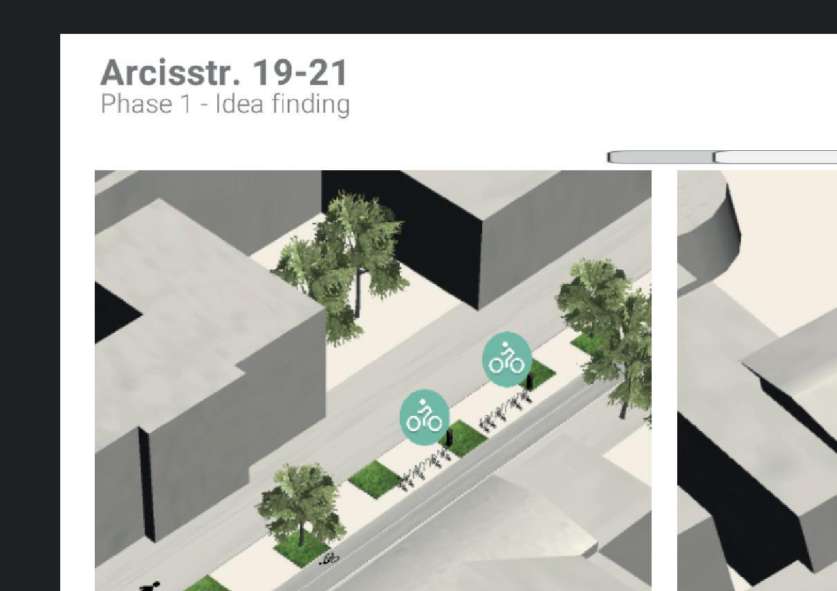
Red streets are in phase 1 - idea finding. Here it is possibile for the citizen to participate and design.
29

30 On the upper right side we find a chat forum. Here all participants can exchange open questions or discuss specific topics.

31 If you select a street of phase 3, exemplified here by the Königsplatz, a pop up window opens. Here you will find the collected information about the measures that are currently under construction. This information can look very different, not only as shown here via images. Also imaginable are: live webcam, text, videos, 2D plans, etc.

32 In phase 2 a new window opens in the full screen. An active 3D model shows the finished planning results for a part of Gabelsbergerstraße. In addition to the model, there is an explanatory text on the right. Once citizens have been sufficiently informed, they can cast a vote and, if they wish to make changes, they can set a pin by dragging and dropping. If other comments have already been pinned, they are visible to everyone.

33 In the phase of idea finding, a pop-up window opens to provide initial information. Since in this phase the citizen can actively design, here is an explanatory video on how to do this. On the right side you can see examples of drafts from other participants. On the top right you have 2 buttons. With the left one you get into the participation window. With the right one you can see the information in full screen.


34 If you have switched to the full screen mode, you can view the screenshots of the other participants in detail. Because not everyone has to create themselves, if your own idea is already there or you want to get an impression first. You can also comment and rate the designs.


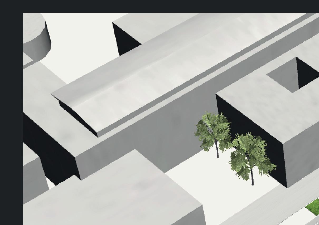
35 If you want to realize your own idea, because you have not found anything suitable among the proposals, you will get to this view. Here you can see the selected street on the left, as it looks at the current time but without cars. Accordingly quite empty. On the right side in the interface, you can see the climate trend, where initially all values are still at zero. There are 4 values that can change: Air quality, CO2 avoidance, accessibility, unsealed surface. These are currently only for illustration.


36
Now you can see in the model how the participant started to add the first objects to the topic Surfaces. In this case, it is an extension of the sidewalk area in front of the entrance to the university and a bicycle highway opposite. As a buffer zone between them, green areas were added. Since this would change the type of surface to the existing one, you can see in the climate trend how the amount of unsealed area increases. In general, you can already see the first change in the other values here as well.

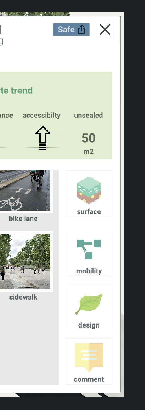


The wishes of the participant are almost completely implemented and we can look at the final result. With this design the climate trend improves noticeably and the participant gains an understanding of what we could influence with it.
37


Now the design is complete and we can save or share it at the top of the interface.
38
Of course, you also have the option to move freely along the road using the mouse and +/- key. In this way, you can take a closer look at different situations and, if necessary, come up with further ideas that are currently not provided by the planner.
For this purpose, as in phase 2, there is a pin to which we can attach a comment.


I think my tool is good at communicating very simply and intuitively to the participant what our future could look like. However, of course, not only the limitation or prohibition of individual traffic is a factor that influences the street space. Does it really need a radical cut to redesign the space or could we not even start today with the tool to bring about change and create a development from it. Certainly it would be possible, but at the same time it would increase the complexity of the tool and then it would be questionable whether or how well this would be used. I think participation has to be fast, comfortable and attractive in this day and age. Attractiveness is not only about design but also what motivates me to participate in the process. I think my concept needs some improvement here. Sure it‘s exciting to be part of the design, but who has time for that and who can assure me that I have real influence? If necessary, a method must be found here to generate a reward system and thus generate a large number of participants. One aspect that continues to be exciting for me is how much participation helps and how to simplify this process. Currently, one still has the feeling that from a certain degree only more challenges and hurdles are generated and planners can also not use 1000 ideas to design something new. Nevertheless, in my eyes it is important to incorporate the broad opinion of society and to implement it. Too often, planners design objects that are of limited help to the public user. Architecture and public space belong to everyone.
39 Discussion
40 Aside from the basic discussion about my tool, there is also room for improvement in the details. Especially in phase 3 there are some questions, which I try to answer in the Outlook. Is the viewing angle from the bird‘s eye view correct, or would it make more sense from the height of the real viewer? Currently you can add an infinite number of objects to the model. How do you achieve a logical limitation Ishere?there a hierarchy in which the objects are arranged and prioritized or is every object of equal value? Is the climate trend really only a visualizing tool for the learning effect or could it be represented realistically to be closer to reality?
As shown in the graphic on the right, I have some ideas on how to further develop the participation tool. Despite the fact that it can work independently and therefore also across cities, I think it would make sense to couple it with the digital twin. This way, the planner would already have an enormous insight into the data collected in the respective street and the program could even generate suggestions based on this data. In addition, the model would have a more accurate representation and would contribute to the credibility of the participation. One goal would certainly be to have a unified base file that is accessible to everyone and thus to keep track of the data. The information would be stored in one place. To relieve the planner of the worry of 1000 ideas, one could create a heat map from the collected data. This could be controlled via layers and individual elements could be checked more precisely. This way, the planner would have a rough overview and can create his design from it. Furthermore, I would like to see accessibility via smartphones, as far more people would have the chance to participate. Not everyone has a computer, but almost everyone has a smartphone. It would additionally be more flexible and also editable on the go in a free time. Finally, it would be possible to create a database with all possible measures or objects that can be inserted into the model. Attached to this would be another database that assigns each object the exact values to the climate trend.
41 Outlook
42 More prezise output by using a database Accessible smartphonesby Creating a catalog hierarchywithmeasuresofa A digital twin as basis model
43 Feedback
Overall, the project more than met my expectations. I learned new ways to create ideas and used new tools and programming to illustrate those Theideas.critiques were very regular, which helped to make steady progress and the feedback was always honest, fair, helpful but also consistent. What additionally helped to understand the matter of urban planning in general were the many insights through the guest lectures. Especially the first events showed that it is possible to do interactive lectures even though you are studying at home. This was challenging, but also a lot of fun and helped to get to know the other students. I only found it a little unfortunate that the exchange with the other students almost completely collapsed after the first events and that it was hardly possible to help each other. Surely it was also our own responsibility to open a chat. Perhaps this could be included for the next semester from the beginning.
44
4545 Contact Karl Rösler WiSe0372622120/21
46