

INTRODUCTION
1. NEW MAHABALESHWARCHARACTERISTICS:
• District of New Mahabaleshwar: Satara district.


• Zone: Eco Sensitive Zone, to be declared first in India by a notification of the Ministry of Environment and Planning, India In the year 2001.
• Project handled by: Maharashtra Tourism Development Corporation (MTDC).
• Area: 38,944 hectares of land and will extend its current base (Mahabaleshwar) to Koyna Dam.
• Planning Authority: Under the Maharashtra Regional Town Planning Act, 1966, appointed MSRDC as a special planning authority.
• Villages to be developed: 61 villages of Jaoli, Patan and Satara tehsils in Satara district.
5. AIM AND OBJECTIVES:
1. AIM:
2. REASON BEHIND DEVELOPING NEW MAHABALESHWAR:
• Over saturation of the current site.
• The new site will open new destinations for frequent travelers and will open new avenues for suppliers.
• Planned development with a focus on boosting infrastructure, enhancing the economy while protecting the ecology of this hill station.
MAHARASHTRA, INDIA SATARA, MAHARASHTRA
• To prepare regional plan of Eco Sensitive Zone (ESZ) of New Mahableshwar
2. OBJECTIVES:
• To study the existing conditions and situations of the study area.
• To examine the existing aspects for the development in future with respect to land, water and the mobility of people.
• To define a framework that will help for implementation of the plan and projects in the Satara region in to upgrade the infrastructure facilities and employment by promoting tourism.
• To formulate the strategies and policies in order to grow the economy.
1.1 Introduction

• Currently, Mahabaleshwar along with Panchgani are promoted as hill stations, while Tapola is promoted as an adventure site.
• Opportunities for employment generation for the local people residing. ❑
HIGHLIGHTS
: Total area : 389.44 Sq. Km i.e. : 38,944 Ha Elevation : 1,353 m (4,439 ft) Density : 240 Sq/m Population: 31,371 Literacy : 83.91 % (2011 census) Sex ratio : 937 (2011 Census)
MUMBAI PUNE SATARA JAOLI SATARA PATAN SANGLI RAIGARH PUNE SOLAPUR 316 Kms 113 Kms 113 Kms 172 Kms 113 Kms 255.8 Kms STUDY
1
AREA BOUNDARY, NEW MAHABALESHWAR
REGIONAL CONNECTIVITY:
4. ADMINISTRATIVE DIVISON :
The region of Satara basically has three tehsils:


Nearest Airport: Pune International Airport


Nearest Railway Station: Pune (JN ) Railway Station B
‘ DETAIL AT A ‘
Villages in Jaoli: 16 Nos.

Can travel by: • Bus • Taxi • Car • Town car
Nearest railway station:
• Satara Railway Station: • 115 Kms from Pune
Can also travel by: • Bus • Taxi • Car • Town car
‘ DETAIL AT B ‘
Villages in Satara: 8 Nos.
KEY MAP OF TEHSILS IN THE STUDY AREA:
Name of Taluka AREA OF TEHSIL (Sq.kms)
AREA OF ESZ (Sq.kms) % OF TEHSIL No. of Villages (Total)

No. of Villages (ESZ)

‘ DETAIL AT C ‘
Villages in Patan: 37 Nos.

TEHSILS 1.2
JAOLI PATAN SATARA
SATARA 911 128.00 14 216 8 JAOLI 596 109.045 18.2 162 16 PATAN 1386 152.40 10.2 344 37 TOTAL 2893 389.445 12.16 722 61
2
A C Introduction


LANDMARKS AND CONNECTIVITY 1. BACK TO 200 B.C Historical inscriptions of circa: oldest known place Karad. 2. 451 & 455 CE. Empire of Chandragupta II. 3. LATER IN 1663 Chatrapati Shivaji Maharaj conquered Satara. British acquired the hills of Satara. 4. IN 1819 5. IN 1828 Regular visitors like Sir Mountstuart Elphinstone, Arthur Malet 7. BY THE END OF 19TH CENTURY Become an attractive popular hill station of world renown. 6. AROUND 2019 -2020 Over saturation of the site so New Mahabaleshwar. LANDMARKS : TIMELINE : NATIONAL HIGHWAY 4.1% STATE HIGHWAY 0.0064% MDR 13.3% ODR 9.3% Village road 73% National Highway State Highway MDR ODR Village road Length of Roads in Kms : LIST OF ROADS IN THE STUDY AREA: National Highway – 25.8 State Highway – 2.57 MDR – 58.82 ODR – 58.75 Village Road – 251.79 Total: 397.73 Kms Kaas Lake Kaas Patthar –Valley of Flowers Thoseghar Koyna Dam CONNECTIVITY : SATARA JAOLI PATAN KEY MAP : 1.3 Introduction 3
PHYSIOGRAPHY
ASPECT HILLSHADE SLOPE CONTOURS

• The map indicates the directions of physical slope face.

• The map shows the topographical shape of hills and mountains that indicate the slope, mountain ridges.

• Green shows lower elevation.
• Red shows higher elevation.


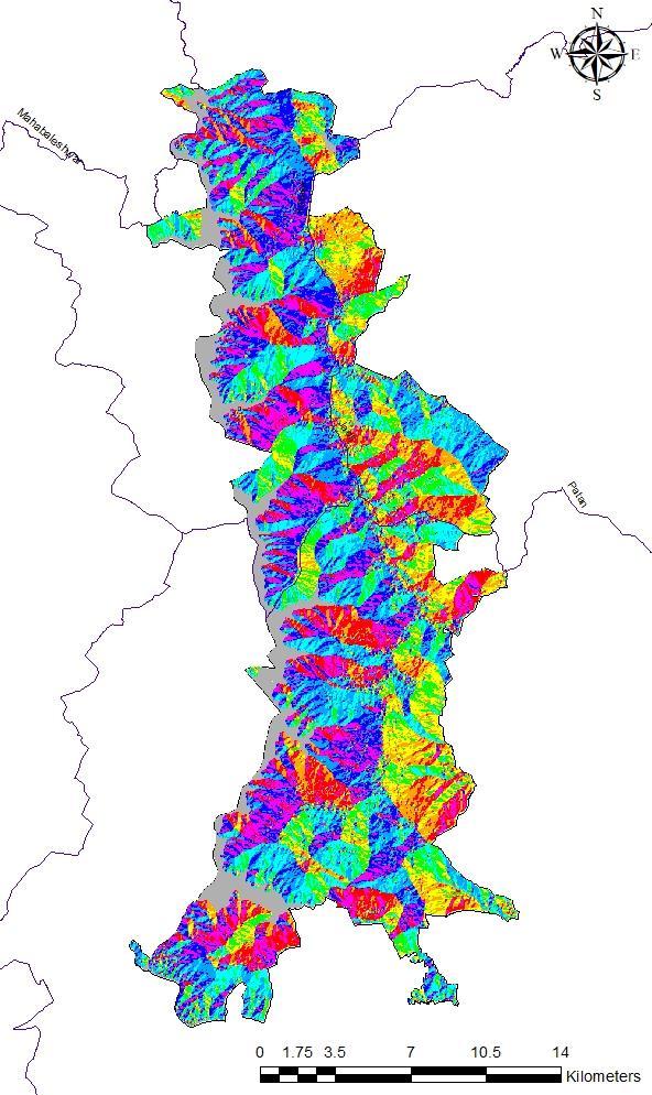
• Contour interval is 100.
• Closer the contour higher the elevation.

LEGEND : LEGEND : LEGEND : LEGEND : 1.4 Introduction 4
REGIONAL PLAN OF SATARA DISTRICT

2016-36
• The then Prime Minister of India Smt. Indira Gandhi had suggested the Government of Maharashtra to take actions for protection and conservation of hilly areas in the Western Ghats particularly Matheran, MahabaleshwarPanchgani from environmental point of view.
PRESENT ENVIRONMENTAL CONDITIONS:
• Western sub tropical hill forest type occurs in Sahyadri ranges where altitude is more than 1,000 meters above mean sea level and rainfall exceeds 2500 mm.
• Shifting cultivation, uncontrolled grazing, heavy precipitation have led to degradation of these areas.
• Main species are Syzigium cumini, Actinodaphne angustifolia, Terminalia chebula, Memecylon edule, Catunaregam spinosa, Phyllanthus emblica, Olea dioica, Acacia concinna etc.
• Bamboo is absent. The height of trees varies from 5 to 12 meters.
• The trees are generally of spreading habit.
• Shikekai and Hirda occur predominantly.
Introduction
EARLIER PLANNING EFFORTS
•
• In these type of forests, the leaves of all trees are not shed at a time. That is why these forests appear always green.
1.5
Evergreen forests are found between the western tropical hill forests and Southern moist mixed deciduous forests.
5
•
ESSENTIAL UTILITIES AND INDUSTRIES PERMITTED IN GREEN/AGRICULTURAL ZONE


•
•
•
•
•
• Petrol pumps
•
• Kerosene depot
•
•
RESTRICTIONS: Introduction
• Quarrying and Mining activities shall be banned in this area. No fresh mining lease shall be granted in the Eco Sensitive Zone.
• There shall be no felling of trees whether on Forest, Government, Revenue or private lands within the Eco-Sensitive Zone, without the prior permission of the State Government
• Tourism activities shall be as per a Tourism Master Plan to be prepared by the Department of Tourism of the State Government.
• Extraction of ground water shall be permitted only for the bona fide agricultural and domestic consumption of the occupier of the plot.
• The use of plastics within the Eco Sensitive Zone shall be regulated by the Monitoring Committee.
1.6
Agro based industries
Bee keeping
Sericulture
Nurseries
Floriculture
Mushroom farming
Gas filling stations
Primary and Secondary School
Primary Health Centers A. Area of Mahableshwar Panchgani Region = 237.28 sq. kms B. Of the above (1) Mahableshwar Municipal Area = 19.55 sq. kms (2) Panchgani Municipal Area = 6.16 sq. kms (3) Gaothans outside Municipal limits = 0.95 sq. kms C. Residential Zone outside Municipal limits = 1.66 sq. kms D. Forest Zone = 123.96 sq. kms E. Green Zone = 83.72 sq. kms
EARLIER PLANNING EFFORTS
6
DECLARATION
SENSITIVE
• The Western Ghats region is known as one of the eight 'hottest' biodiversity hotspots of the 34 identified biodiversity hotspots worldwide.
• The region hosts a tremendous diversity of plant and animal life.
• Nearly 1,452 species of plants belonging to 680 genera of 156 families have been recorded
• a total of 251 species are reported to be ‘endangered’ in Maharashtra state of which 20 species are found in the study area.
• As defined in the government of Maharashtra notification of 29th April 1983, Central government notified the Mahabaleshwar Panchgani as Eco Sensitive Zone.
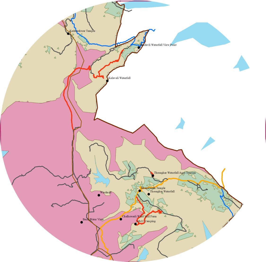
SAYADRI TIGER RESERVE :
• The Sahyadri Tiger Reserve is located in the Sahyadri Ranges of Western Ghats in Maharashtra
• These ranges form a common boundary between Maharashtra, Karnataka and Goa, and comprise of rich evergreen, semi-evergreen and moist deciduous forests.
• It is the first Tiger Reserve of Western Maharashtra and the fourth Tiger Reserve of the State spreading over two Protected Areas of Koyana Sanctuary (KWLS) and Chandoli National Park (CNP).
• There are total 8 villages in the STR buffer zone under study area.
AREA OF THE FOREST:
Core Area : 600.12 sq.kms. Buffer Area : 565.45 sq.kms.
Total : 1165.56 Sq.Kms.
• The Tiger Reserve is home to the endangered species of top carnivores such as Tiger, Wild dog, and Leopard.
• The herbivores include Gaur, Sambar, Four Horned Antelope, Mouse Deer and Giant Squirrel.
• As many as 30 species of mammals have been recorded. In addition, the area is home to Vultures and Crocodiles.
• The habitat also supports Hornbills, and many other endemic Birds. There are 58 varieties of snakes.
• The Blue finned Mahasheer fish is present in the Koyana waters.
• Presence of 5 to 7 tigers has been noticed, at Shirshinge, Pali, Mhalunge, Navaja, Takavli, Ghatmatha, Male, Rundiv, Siddheshvar, Dhakale areas.
17/01/2001:
Mahabaleshwar Pachgani Region has been declared as Eco Sensitive Zone under Environment Conservation Act, 1986 by the Ministry of Environment and Forest Notification No. 5052(E) dt.17/01/2001 in order to protect and conserve the region.
By government Notification, Urban Development Department dt. 18/07/2001 government of Maharashtra has constituted the “Mahabaleshwar-Pachgani Region Regional Planning Board” for the preparation of the said proposed Regional Plan.

ECO SENSITIVE
1.7
ZONE
LEGEND : NOTIFICATION DATED
STR BUFFER
OF ECO
ZONE: MAP OF THE STUDY AREA SHOWING THE BUFFER ZONE AND THE STR BOUNDARIIES: STR CORE ZONE
ZONE
SAYADRI TIGER RESERVE AREA
PATAN TALUKA
SATARA TALUKA
7
JAOLI TALUKA
Introduction
FEATURES OF KOYNA
• Located on the mountainous Sahyadri range of the Western ghats that run North to south along western coast of India.
• Bound by valleys on all sides
• It reaches a height of 1,439 m (4,721 ft) at its highest peak above sea level, known as Wilson/Sunrise Point.
• Maximum elevation: 4,784 ft
• Average elevation : 3,573 ft
• Originates from mountainous hills of Sahyadri famous hill station Mahabaleshwar along with Savitri, Gayatri, Venna and Krishna.
• Savitri, Gayatri flow westward and Venna flows on eastern side.
• Koyna flows down for 64 kms.

• Average rainfall: 5000 mm.
• Built in rubble concrete, natural geographic utilized to construct the dam.
• Rocky hills and red soil valleys.
• This Koyna Project is an engineering sculpture the efforts of thousands of workers, and hence The lifeline of Maharashtra’.
❑ HIGHLIGHTS :
• Total Area of water body : 4199.62 Ha


• 807 m long and 103 m high.
FEATURES OF KOYNA : LEGEND:
• Catchment area of Koyna: 891.78 Sq.Kms
• Kolkewadi: 25.40 Sq.Kms
MAP SHOWING WATER BODY :
MAP SHOWING AREA BOUNDARIES :
SAYADRI TIGER RESERVE AREA
PATAN TALUKA
SATARA TALUKA
120018029
JAOLI TALUKA
SHIVSAGAR JALASHAY
KOYNA WATER BODY URMODI RESERVIOR KANHER
SHIVSAGAR JALASHAY
- Water Body
1.8 Introduction 8
Origin: Mountainous hills of Sahyadri near Mahableshwar along with the rivers Savitri, Gayatri, Venna and Krishna.
Flow of Koyna River: North – South Direction Flows down for 64 kms.

Height and Elevation:
Height of 1,439 m (4,721 ft) Maximum elevation: 4,784 ft Average elevation : 3,573 ft
Core Area : 600.12 Sq.Kms.
Buffer Area : 565.45 Sq.Kms.

Eco Sensitive Zone: Under Environment Conservation Act, 1986 by the Ministry of Environment and Forest Notification No. 5052(E) dt.17/01/2001.
SAYADRI TIGER RESERVE AREA

MAP OF THE STUDY AREA:
1. Zero Population Villages:
• Bhambe
• Jambruk
• Chimbare
• Dastan
Detail at ‘1’

2. Sahyadri Tiger Reserve buffer: 8 Villages


• Vasota
• Deur
• Vele
• Jambruk
• Nahimbe
• Ambegarh
• Bhambe
3. Rehabilitated Villages:
• Devghar Tarf
• Nahimbe
• Ambegarh
Detail at ‘ 2 ’

• Chimbare
• Dastan
• Gojegoan
Detail at ‘ 3 ’
MAIN FEATURES OF AREA STUDY : 0 3.5 7 10.5 14 1.75 Kilometers
1.9 Introduction 9
GROWTH PATTERN AND HISTORY
HISTORY :
The graph above shows the decadal growth of the study area for the years of 1991, 2000 and 2011.
The graph above shows the Sex ratio of the region is 931.
According to the census of 2011, The graph above denotes the Decadal growth of Satara, Jaoli and Patan followed by the negative growth in Satara, Jaoli and the positive in Patan.
•
•
•
DECADAL
OF NEW
SR. NO. YEAR 1991 2001 2011 1 INDIA 838,583,988 1,028,737,436 1,210,193,422 2 MAHARASHTRA 78,937,187 96, 878,627 112,374,333 3 DISTRICT 2,451,372 2,808,994 3,003,741 4 NEW MAHABLESHWAR 27,227 37,504 31,371 GROWTH RATE OF NEW MAHABALESHWAR: 1 2 3 YEAR 1991 2000 2011 POPULATION 27,227 37504 31371 0 5000 10000 15000 20000 25000 30000 35000 40000 POPULATION DECADAL GROWTH DECADAL GROWTH OF ESZ , 2011 CENSUS : SATARA JAOLI PATAN PERCENT -25.74 -61.4 11.97 -70 -60 -50 -40 -30 -20 -10 0 10 20 PERCENT DECADAL
SATARA JAOLI PATAN REGION SEX RATIO 922 887 943 931 850 860 870 880 890 900 910 920 930 940 950 RATIO SEX RATIO SEX RATIO OF TEHSILS:
93% 7% SC ST
•
Post Independence Era (to cater to the needs of electricity, the water reservoir is diverted to the westward through tunnel)
Utilizing an altitude of Sahyadri a 600 MW, under ground power station is constructed at Pophali.
The water coming out of this powerhouse is stored on Kolkewadi reservoir.
POPULATION
MAHABLESHWAR
GROWTH OF ESZ
• The population for SC i.e. 93% than that of ST followed by 7%.
COMPOSITION OF TRIBAL POPULATION :
10
•
ANALYSIS
PHYSICAL INFRASTRUCTURE TRANSPORTATION

INTRODUCTION TO REGION : TRANSPORT SYSTEM

▪ Mahabaleshwar Eco-Sensitive Region consist of 3 talukas namely – Satara, Patan and Jawali. Includes 1 National highway, 1 State highway , Major district roads, Other district roads and village roads.


▪ The study region does not consist of any railway line and airport.


▪ Transport infrastructure forms a backbone of any economy and plays important role in the development of a region. It is also one of the most important infrastructure facilities of any city or region.
RAIL CONNECTIVITY

• Satara Railway Station is the nearest railway station and lies on the Pune–Miraj line of the Central Railways and is administered by the Pune Railway Division.

• This station connects Satara with major Indian cities such as Mumbai, Pune, Bengaluru, Nagpur, Sangli, Miraj, Kolhapur, Ahmedabad, Jaipur, Delhi, Goa, and Dhanbad through express trains.
• The station has three platforms and five tracks.
AIR CONNECTIVITY
• Pune's Lohegaon Airport is the nearest airport to Satara & it is located at a distance of 120 km from Satara. All major Indian cities, including Ahmedabad, Bengaluru, Chennai, Delhi, Goa, Hyderabad, Kochi, Kolkata, and Srinagar, are well connected to the airport.


• Mumbai’s Chhatrapati Shivaji Airport is located at a distance of about 264 km from Satara and Chhatrapati Rajaram Maharaj Airport Kolhapur is located at a distance of 124 km from Satara.
city
Fig: Satara Railway Station Fig: Pune International Airport Map Showing Inter-Region Connectivity ROAD NETWORK: Map: Maharashtra State Road Network Map MUMBAI PUNE SATARA BARAMAT AHMEDDNAGA SANGLI KOLHAPUR RATNAGIRI SOLAPUR NASHIK DHULE AURANGABAD OSMANABAD LATUR BEED NANDE PARBHAN HINGOLI JALANA JALGAON SATARA MAHABALESHAR MEDHA WAI UMBRAJ KARAD PHALTAN DAHIWADI 25KM 50KM 75KM Major cities Airports 7.1.1 Physical Infrastructure - Transportation 0 340 680 170 Kilometers 0 10 20 30 5 Kilometers TRANSPORTATION 12
ROAD NETWORK:
▪ New Mahabaleshwar Eco Sensitive Zone is connected by only Road Transport System.
▪ National Highway 166E in the region connects Patan to the Chiplun, The National Highway 48 Mumbai-Bangalore is also passing from nearby and the state highway named ThosegharChalkewadi – Patan road passes through Thoseghar- Chalkewadi- Ghanbi- Karvat- Ker
▪ The total length of the roads in the region is 397 73 km ▪ In the region, 25.8 km covered by National Highway, 2.57 km is covered by State Highway.
▪ Major contribution in the road is of ODR measures 251.8 km
▪ Lowest Contribution in the roads is of state highway which measures 2.57 km which lies in Patan taluka
REGION : ROADS AT A GLANCE


▪ There are possibly two modes of transport for mountainous or hilly areas, namely, roads and railways.
▪ In the study region the villages are connected to each other only with the road network
▪ Most of the roads can be seen are of 7.5 m wide village roads in the region .
▪ Patan – Chalkewadi – Satara is the main spinal road to which other village roads are connected.
LENGTHWISE DISTRIBUTION OF THE ROAD IN THE REGION
SR.NO. CATEGORY LENGTH OF THE ROAD (IN KM)


STUDY REGION JAWALI SATARA PATAN
1 National Highway 25.8 0 0 25.8 2 State Highway 2.57 0 0 2.57 3 MDR 58.82 16.84 32.5 9.48 4 ODR 58.75 6.7 25.15 26.9 5 Village road 251.79 46.7 42.3 162.79 TOTAL 397.73 70.24 99.95 227.54
Percentage of Length of the Roads in the Region NATIONAL HIGHWAY 4.1% STATE HIGHWAY 0.0064% MDR 13.3% ODR 9.3% Village road 73%
Villages Physical
Transportation ROAD
13 KEY
Map: Road Network
Infrastructure -
NETWORK
MAP :

ROAD DENSITY: Sr no. District /Region Density /100 sq.km. area Density /lakh population 1 Study Region
2
3 Nashik
4
5
6
ROAD DENSITY COMPARISON: TALUKA ROAD LENGTH(km) POPULATION AREA (in
ROAD DEN. (LENG./POP.) ROAD DEN. (LENG./AREA)
PATAN
New Mahabaleshwar
High Density Medium Density Low Density 0 20 40 60 80 100 120 140 160 Study Region Pune District Nashik District Sangli District Maharashtra India Density /100 sq.km. area Map: Village wise Road Density Map Bar Chart: Road Density Comparison 7.1.3 Physical Infrastructure - Transportation ROAD DENSITY 14 KEY MAP :
11.115 0.14
Pune District 119 398
District 123 300
Sangli District 142 416
Maharashtra 97 255
India 22 52
Sq.Km)
JAWALI 70.24 3171 150.86 0.022 0.465 SATARA 99.95 9007 58.38 0.011 41.57
227.54 19193 180.19 0.011 1.26
397.73 31371 389.44 0.044 43.29
INTER-REGION CONNECTIVITY
▪ Maharashtra State Public Transport System is pretty good in the district connecting it other parts of Maharashtra State.
• Local buses run by MSRTC (Maharashtra State Road Transport Corporation) or run by private operators are easy mode of transportation within Satara District.
• Satara ST Depot is well connected by daily buses from Mumbai Central, Thane, Swargate, Ratnagiri, Kolhapur, Vijapur, Nashik, Belgaon, Latur, etc.
INTRA- REGION CONNECTIVITY
▪ Intra-Regional connectivity benefiting farmers, small scale industries and backward regions by connecting them to important regional trade centers, religious and tourist places.
▪ New Mahabaleshwar Eco Sensitive Zone is connected by Maharashtra State transport buses. All the major settlements within the region are connected by public transport.
▪ Frequency of buses from Satara, Medha and Patan Depot is good and connecting only major settlements. Private vehicles like jeep and other service vehicles are helps in connecting the remote settlements.
Table: Frequency of Buses in Study Area, Source: MSTRC- Satara, Patan & Medha Depot

Satara Depot
Satara-Medha - 34.6km 12 Satara-Patan - 66km 4
Satara-Kusavade -37.5km 3 Kusavade-Satara - 37.5km 2 Satara-Jungati - 38.1km 1 Jungati-Satara - 38.1km 1 Satara-Kelavali - 38km 6 Kelavali-Satara- 38km 6 Satara-Alawadi-33.5km 1 Alawadi-Satara-33.5km 1

Patan Depot
Patan-Bondri - 5.8km 2 Bondri-Patan - 5.8km 2 Patan-Chafoli- 13.5km 2 Chafoli-Patan- 13.5km 2 Patan-Bharsakhale-20.2km 2 Bharsakhale-Patan-20.2km 2 Patan-Divshi- 20.7km 2 Divshi-Patan- 20.7km 2 Patan-Mhavshi- 6km 2 Mhavshi-Patan- 6km 2 Patan-Vatole- 24km 2 Vatole-Patan- 24km 2 Patan-Vankusavade-30 1 Vankusavade-Patan-30 1
Medha (Jaoli) Depot Medha-Bamnoli- 30km 4 Bamnoli-Medha- 30km 4
Routes Frequency Bus Routes Frequency
Bus
Map: Intra-Regional Connectivity Satara Depot Medha Depot Patan Depot Jaoli/Medha Patan Vatole Bondri Divshi Chafoli Bharsakhale Kusavade Vankusavade Kelavali Alavadi Bamnoli Jungati Satara 30 KM 34.6 KM 33.5 KM 38 KM 37.5 KM 38.1 KM 66 KM 24 KM 5.8 KM 30 KM 20.2 KM 7.1.4 Physical Infrastructure
Transportation REGIONAL CONNECTIVITY 15 KEY
-
MAP :
ROAD SCHEMES & INDIAN ROAD CONGRESS STANDARDS FOR RURAL ROADS:
▪ While surveying the study area of 3 tehsils, we found that some of the roads are built under the schemes provided for Rural road development. Some of the village roads are in good condition as recent constructions while some roads are in poor condition.
▪ Maharashtra State Road Development Corporation deals with properties and assets related in state highways development.
▪ Public Works Department (PWD) of Maharashtra State is responsible for the construction and maintenance of MDR & ODR.
▪ Village roads are constructed and maintained by PWD of Maharashtra State. Pradhan Mantri Gram Sadak Yojana & Mukhyamantri Gram Sadak Yojana are the schemes related to village roads.
Road Classification
Roadway Width in Meters Right of Way in Meters
Plain & Rolling Terrain
Mountainous & Steep Terrain Study Area Plain & Rolling Terrain
Mountainous & Steep Terrain Study Area
National & State Highways Single Lane 12 6.25 12 45 24 45 Two Lane 12 8.80
Major District Roads Single Lane 9 4.75 4.75 25 18 18 Two Lane 9 -
Other District Roads Single Lane 7.5 4.75 4.75 15 15 15 Two Lane 9 -
Village Roads Single Lane 7.5 4 4 12 9 9
Ref: Indian Roads Congress, Govt. of India
ROAD CONDITION: 1) National Highway:
Karad-Chiplun Road (NH 166E)


Terrain: Plain & Rolling Terrain
Average width of carriage way is 7M
Width of roadway (Carriage way + Shoulder) is 12M

▪
▪
▪
▪
7 M 12 M
16
Source: Primary survey; Karad-Chiplun Road Source: Primary survey; Karad-Chiplun Road National Highway Section
ROAD CONDITION
MDR 29: PatanThoseghar Road


Terrain: Mountainous & Steep Terrain
Average width of carriage way is 3.75M
Width of roadway (Carriage way + Shoulder) is 4.75 M
ROW: 18 M
ODR 133

Terrain: Mountainous & Steep Terrain
Average width of carriage way is 3.75M


Width of roadway (Carriage way + Shoulder) is 4.75 M

ROW: 15 M
VR 97
Terrain: Mountainous & Steep Terrain
Average width of carriage way is 3 M
Width of roadway (Carriage way + Shoulder) is 4 M
ROW: 9 M
Source: Primary survey; MDR 29 Source: Primary survey; MDR 29 Source: Primary survey; ODR 133 Source: Primary survey; ODR 133 Source: Primary survey; VR 67- Divshi Source: Primary survey; VR 97- Bondri
▪
ROAD CONDITION: 2) Major District Roads: 3) Other District Roads: 4) Village Roads:
Major District Road Section Other District Road Section Village Road Section
▪
▪
▪
▪
▪
▪
▪
▪
▪
▪
▪
▪
▪
▪
9 M 4 M 3 M 3.75 M 4.75 M 15 M 18 M 4.75 M 3.75 M
17
ROAD CONDITION
PROPOSALS
PHYSICAL INFRASTRUCTURE TRANSPORTATION
▪
Transport Improvement Strategies & Proposals:
Objectives for Transport Improvement
▪
▪
▪
INTER & INTRA REGIONAL CONNECTIVITY
▪
are:
To promote smooth movement of traffic both regional and local adopting transport system management measures such as frequency of public transport buses.
▪ To develop a eco-friendly transport system operation with priority on public transport system
▪ To facilitate improved pedestrian environment in conservation and transition zone through vehicle restriction strategies and better pedestrian facilities
Issues in Transportation:
Poor quality of Public Transport in the Region which is hampering the circulation within the region.
▪ Less Intra Regional connectivity to Patan, Jaoli tehsil and remote villages.
▪ Unavailability of alternate mode of transport leading to heavy dependency on existing forms of transport.
▪ Roads in remote settlements like Marathwadi, Chafoli, Divshi, Khivshi are not in good condition.
▪ Deur, Vele, Nahimbe, Kelavati villages don’t have all weather motorable roads.
Proposal for Inter Regional Connectivity:
Rail Network:
Satara has railway station near Mahuli, about 7 km distance on the Satara Pandharpur road from Satara Bus stand. Satara is on the route from Mumbai to Miraj, Sangli, Kolhapur and Bangalore.
▪ Proposal of double line network is necessary for now to cope up with the future transportation needs of the district.
▪ Karad station should be upgraded and Karad to Chiplun railway route proposal is necessary for the better connectivity of region.
Road Network:


▪
The major National Highway (NH166E) is to be upgraded to up to 45 m in plain areas and 24 m in hilly areas
The inter region public transport is operated by MSRTC (Maharashtra State Road Transport Corporation). There is need to increase the frequency of buses from other part of state.
▪
▪
▪
All the tehsils are well connected with Satara however direct frequency among other talukas is less and it is recommended to increase.
Extra buses should be provided on weekends to increase tourism potential of the region.
Proposal for Intra Regional Road Connectivity:
It is proposed to develop local public transport which would consist of 30 seater mini buses, 10 seater cabs and private taxis operating on environment friendly fuel such as LPG or CNG.
The local bus routes have been planned along MDR which have maximum number of tourist spots, so that tourist could be directly dropped at their destinations.
▪ In order to smooth flow of bus traffic on tourist corridors as part of traffic management measures it is proposed to ban on street parking and ensure parking is in designated off street parking lots.
▪
The National Highway, MDR’s has less width in some areas (bottlenecks) which needs to be widened to cater the future travel demand.
▪ In order to ensure more safety in the region it is proposed to install retro reflective traffic signs, pavement markings and ensure adequate street lighting along major tourist spots and roads.
▪ Mobility management center is also proposed which will promote integration between various modes of transport & travel information such as travel schedules, pick up/drop off points, etc and provide transport services of varied choices to its potential users.
Road Signage & Marking:
▪
Provision of Road signs and marking let drivers know what lies ahead. Weather it is a merger or a traffic light, post signs to keep drivers aware of what is coming ahead.
▪
Installation of speed breakers at slopes, railing / Parapet with Indicators on the edge of the road
Landslide Prevention:
▪
The land slide can be prevented by reducing the angle of slope or providing retaining walls, providing sub-surface drains at foot of the hill slope to control seepage flow.
18
PROPOSED ROAD NETWORK

Conservation Zone:
▪
Every settlement should be connected by village roads.
▪ With all permissions & NOC from Forest Department, new access road MDR having carriage way width of 3.75 M wide and approximate length of M is to be proposed for the overall regional connectivity. It will act as a Spinal Cord for a region.
▪ Every settlement should be connected by village roads.
Transition Zone:
▪ New access roads are proposed to tourist spots which will help the tourist to access varied tourist destinations.
▪ Settlement of population less than 500 to be connected by all weather roads

▪ Road upgradation and retrofitting should be done for all the unpaved roads
Developable Zone:
▪ This zone is well connected by the other district roads and village roads.
▪ Retrofitting work of infrastructure and broken road surface should be done for the village roads.
Sr no. Proposals
Road Length Implementing Agency scheme and source of fund
Zone 1 - Conservation Zone


1 Connecting Patan - Chalkewadi MDR to Urmodikas ODR with village road from deur to kelavali 4.27 km PWD, Satara State Road Fund
Zone 2 - Transition Zone
2 kelavali to kelavali waterfall tourist spot 3.15 km ZP, Satara PMGSY
3 MH 11 camping Access road From thoseghar 1.87 Km ZP, Satara State Road Fund
4 MH11 camping access from thoseghar- Chikhlai Road 1.76 Km ZP, Satara State Road Fund
5 Van Kusawade to janai devi Mandir 2.42 km ZP, Satara PMGSY
6 Access road to Thoseghar Waterfall agro-tourism 0.35 Km ZP, Satara MLA funds
7 Marathwadi to Arai waterfall 560m ZP, Satara State Road Fund
8 Divshi road to dhareshwar mandir 620m ZP, Satara MLA funds
Zone 3 - Developable Zone
9 Munavale road to Mahakali temple 0.62 km ZP, Satara PMGSY
10 Sawarghar Road Joining 150 m ZP, Satara MLA funds
11 Kathi Road to Sahadri tiger reserve 150m ZP, Satara State Road Fund
12 Ghanbi Road to Ghanbi Mandav Kada 1.6 km PWD, Satara State Road Fund
19 KEY MAP :

T H A N K Y O U !