6 minute read
Pets
PET SERVICES
Vintage Rambles with rafa and Flake Bailey Bailey
Advertisement
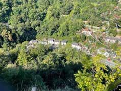
This month we bring you a walk which has lived long in the memory. The route is fabulous with some amazing views but where there are views there are hills and this walk comes with some steep climbs, so is definitely not one for the feint hearted. The first time we did this walk, back in 2015 it left us a little out of breath and we definitely felt we had earned our drink at the end. This time we sent out the lovely Michelle and Dean who have brought the walk up to date with a few tweaks to keep you right on track!
5½ MILE CIRCULAR FROM MATLOCK VIA MATLOCK BATH AND TINKERS SHAFT.
A tough but highly rewarding walk for you and your dog. Despite the medium length this walk should take 21/2 – 3 hours as there are some slow uphill sections. As ever be careful on roads, make sure you wear appropriate footwear for the conditions and as always, follow the countryside code!


START: CHURCH OF ST GILES, CHURCH STREET, OLD MATLOCK. DE4 3BZ
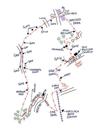
1. Standing on Church Street, with your back to the church, turn right and head uphill. After passing a post box in a stone wall, turn right along a signposted footpath. Continue straight for a short distance and then pass through a metal gate and beneath a metal archway signposted for ‘High Tor Grounds’. 2. Continue uphill for some distance keeping a metal fence on your left. Eventually the metal fence peels off to the left. At this point continue straight uphill. Nearing the top of the hill you will reach a wooden sign board on your right. Turn right just in front of the signboard and take the steps leading uphill. 3. At the very top of the hill turn left. Immediately the path splits into two. Take the left split through some trees and up some more steps. Pass by a large telecoms mast on your left and begin to descend. 4. Further on you will climb down some steps and arrive at a small picnic area with picnic tables. Turn 90 degrees left keeping a wooden fence on your left. After a short distance you will reach a tarmac path. Turn right onto the path and continue downhill. 5. The tarmac path bends sharp left and then continues on to a large wooden gate. Just prior to the gate turn sharp right at a marker post on your right. Follow this path until reaching a T-junction of paths and turn left down some steps. Continue to twist and wind downhill until passing through a metal gate, down a few concrete steps and turn right onto a tarmac path.
6. Continue downhill for a short distance and then pass through a gap adjacent to a wooden gate. After a short distance go under the bridge and turn left onto the tarmac pedestrian walkway. 7. Follow the pedestrian walkway until you reach the zebra crossing adjacent to the train station car park. At the zebra crossing turn right and cross over the bridge to reach the A6. Cross directly over the A6 and continue uphill on ‘Holme Road’. 8. Stay on ‘Holme Road’ as it bends to the left. Continue to pass ‘Masson Road’ on your right and ‘Waterloo Road’ on your left. Further on you will pass a footpath on your right signposted for ‘Matlock’ and then ‘West Lodge’ on your right. The road becomes very narrow and steep. On your right is a stone wall with a hand rail. Where the hand rail ends turn right onto a signposted footpath going steep uphill into some woodland. 9. Continue uphill until you reach two metal posts. At this point ignore the path that bears right and continue bearing slightly left and uphill. Upon reaching a T Junction of paths turn left and continue uphill avoiding the fallen tree. When nearing the top of the hill you will reach a fence and open views on your left. After a very short distance turn right back into the woodland and onto a footpath signposted for ‘Matlock’. 10. Continue along this path with a steep bank down to your right. After some distance at a marker post on your left the path splits into two. Take the left split going uphill. After a short distance pass through a wooden gate and then a marker post on your right. Continue along a lane passing a sign for ‘Tinkers Shaft’ on your left. 11. After a short distance bear right off the lane and head to the left of the viewing platform at ‘Tinkers Shaft’. Continue on this course passing through a wooden gate then turn right onto the lane. 12. After some distance along the lane pass through a wooden gate to bypass a cattle grid. After a short distance, keep your eyes peeled for a right turn at the crossroads of footpaths into a field. Continue downhill keeping some trees on your right. 13. Continue to pass through a small wooden gate adjacent to a large metal gate. Continue to the bottom left hand corner of the next field and pass through a wooden gate. Continue downhill and pass a marker post on your left. After a very short distance, pass through a gap in a wall and continue downhill with a hedge on your right. Pass through another wooden gate and continue downhill with a hedge on your right. Now pass through a wooden gate to continue with a hedge on both sides. 14. Pass through a gap and continue straight downhill. Pass through two stone posts and after a short distance cross over a stile. Immediately after the stile bear right and continue along a path to a tarmac lane. Cross straight over the lane and into another field to continue downhill. 15. At the bottom of this field pass through a metal gate, down some steps and then downhill along a tarmac lane with a stone wall on both sides. Upon reaching a road turn right downhill until reaching a main road. 16. Cross the main road and continue straight to cross over a river bridge. Immediately after the bridge turn right into Matlock Park. Continue along a broad tree lined path to the very far side of the park where you reach a road. Continue along the road for a short distance and then turn right onto a path signposted for ‘Pic Tor’. 17. Cross over a footbridge and at a T-junction of paths turn right. Continue straight ahead and just prior to entering a tunnel turn left along a path signposted for ‘War Memorial’. Follow this path uphill ignoring the path that descends to the right. 18. The path twists and winds to the top of the hill where you will find the Memorial. Just past the Memorial, turn left down some steps and pass through a wooden gate to return to the Church.

This walk is for illustrative purposes only. Voice Magazines Ltd takes no responsibility for anyone who chooses to follow this route and encourages all walkers to obey all byelaws and signs and to respect the area they are walking in, ensuring they pick up all dog mess and obey the countryside code at all times.
Matlock Bath
Starkholmes Matlock Heights of Abraham Tinkers Shaft

