
7 minute read
InfraWorks What’s New in InfraWorks

from AUGIWorld
by AUGI, Inc.

What’s New in InfraWorks
➲ I t is that time again….and it feels like Christmas. All the latest 2021 versions of Autodesk design software are now out. Time to download, install, and open our new subscription software and see what is new in InfraWorks 2021. Like the prior years, collaboration is a crucial part of the design workflow when working on any civil and architectural site project. One of Autodesk’s main focuses on AEC Collection design software, such as InfraWorks, is to enhance the design and collaboration synergy between client, stakeholders, design teams, departments and offices. This keeps companies updated with project milestones, design statuses, and construction updates.
In this article, we will cover over some of the major improvements and enhancements to InfraWorks design and analysis tools for bridges, roads, visualization, and ESRI ArcGIS features.
BRIDGE
For the past few years Autodesk has made some great strides in improving upon the bridge preliminary design and analysis features to create more accurate bridge design that meets local and state ordinances. In this latest version release, Autodesk took it to the next level by improving the editing, analysis, and collaboration design tools to be more accurate and efficient.
There are typically 2-3 design teams that work on bridge design. One is the civil engineer designing the main design road, roadside grading, and utilities infrastructure. Second, is the structural engineer designing and analyzing the bridge structure based on the road type and size. The third, can be a site planner creating an overall 3D preliminary, conceptual modeling site by bringing it all together within InfraWorks. With InfraWorks’ 2021 new Civil Structures workflow, designers can seamlessly share parametric bridge components back and forth between different design software such as Civil 3D, InfraWorks and Revit. InfraWorks 2021 can now publish the bridge model to Revit as an IMX for more extensive design and analysis.
Figure 1
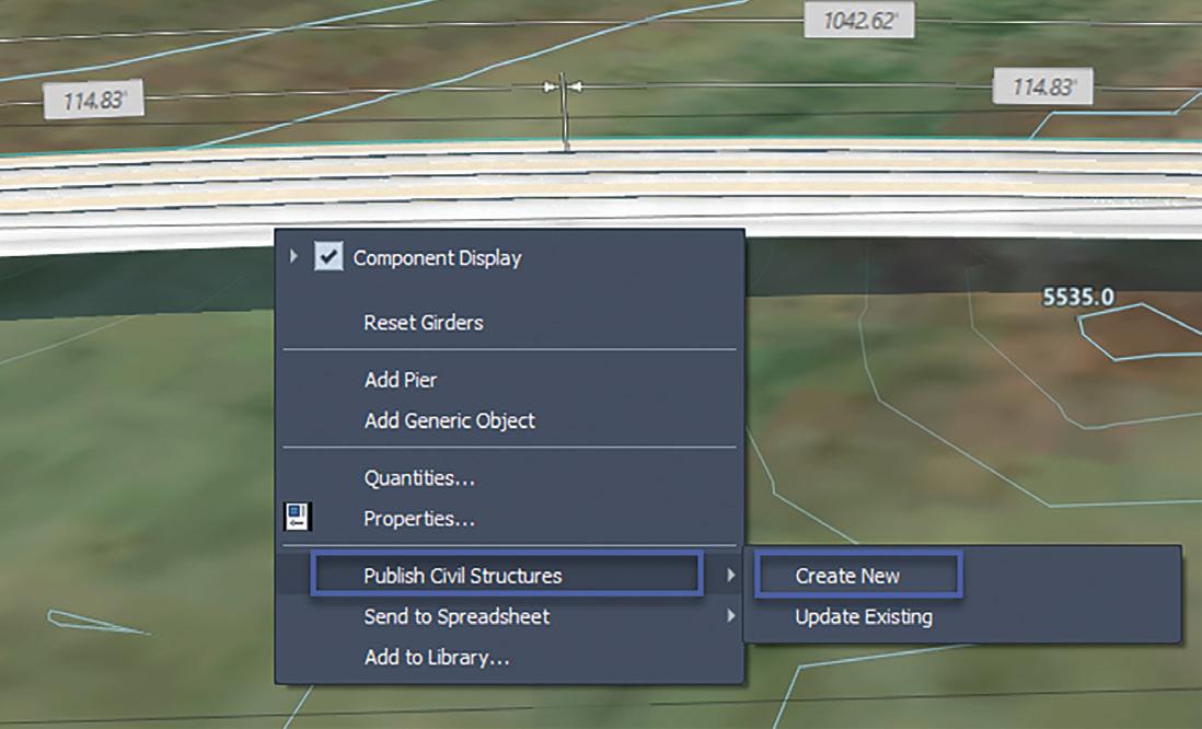
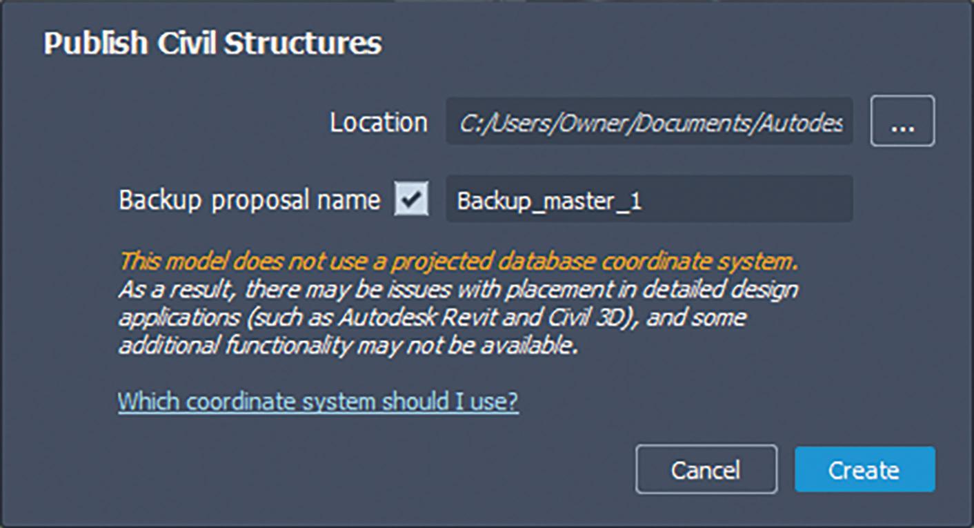
To export the bridge model, simply select the bridge girder, rightclick, select Publish Civil Structures, and then select Create New option. One important note: if you do not have a coordinate system assigned to your InfraWorks model, you will get a notification to assign a coordinate system within the Model Properties (figure 1). Assign the new IMX with a file name and folder location so Revit and Civil 3D designers can access. Then click Create (figure 2).

Figure 3
Next, the structural engineer can access the bridge IMX within Revit to accurately make design changes to the bridge model or component. After making final changes in Revit, the site planner or civil engineer can update his InfraWorks model with the same IMX that was created and changed in Revit by simply selecting the bridge girder, right-clicking, select Publish Civil Structure, and selecting the Update Existing option (figure 3).
Another added feature to the Bridge tools, is the ability to have the bridge deck slope match the super elevation of an imported road corridor from Civil 3D. On top of the features listed above, designers also can modify bridge attributes through an Excel spreadsheet which helps streamline the design workflow. If you select, and right-click on the bridge girder, you will see an option to Send to Spreadsheet and Create New. This will create a structural bridge calculation spreadsheet which you can then edit manually (figures 4 & 5).

After saving the Excel sheet, you can update the bridge model by selecting the bridge girder, then selecting Send to Spreadsheet and Update Existing options. This will automatically update the bridge model (figure 6).
Figure 4

Figure 6
VISUALIZATION
For the past several years many designers have struggled with 4K monitor resolution issues while working in InfraWorks. If you tried to use a 4K monitor with InfraWorks, the interface gets


shrunk down to small icons making it difficult to work in. With InfraWorks 2021, most 4K issues have been resolved by providing a high DPI scaling optimization support for 4K viewing for InfraWorks models. To turn on this feature, access the Application Options dialog box, then click the General section. At the bottom you now have a new option for Use Windows ‘Scale and layout’ settings (figure 7).
If you do plan to use a 4K monitor, there are a few important things you must understand. The high DPI scaling ONLY works for scale factors of 100%, 200%, and 300% on your monitor resolution. Any scale factor in between such as 150% resolution will be rounded to 200% as posted by Autodesk Knowledge Network.
In addition, another known resolution issue as posted on the Autodesk Knowledge Network, “the 3D portion of the InfraWorks user interface does not yet use high resolution DPI scaling. Instead, standard resolution is up-scaled to fit regardless of the monitor setting, which brings aliasing artifacts and can cause some pixilation.”.
ArcGIS
Since the integration of the ESRI ArcGIS, Autodesk has continued making great improvements in streamlining the importing, exporting, and publishing data feature tools in InfraWorks. Now, with InfraWorks 2021, designers can publish out the desired geometry and layer content to an ArcGIS cloud environment while also assigning new attribute names. In addition, this new feature also works when exporting InfraWorks data to an ESRI File Geodatabase format (FGDB). This workflow provides designers more security to sensitive information while publishing (figure 8).
Figure 8

ROAD DESIGN
Another key improvement to InfraWorks 2021, is the ability to access Autodesk Civil 3D geometry accuracy and power for road corridor models when importing into InfraWorks. So, what does this mean since the ability to import a road corridor into InfraWorks already exists? When importing the corridor model through the Data Center, InfraWorks now provides capabilities to configure certain elements of the corridor and convert the corridor into a component road automatically while maintaining certain corridor features. In addition, you can easily update a revised Autodesk Civil 3D corridor which helps streamline the process between both design softwares.

In the Data Source panel, Import option, select Autodesk Civil 3D Dwg. Then browse to your drawing that contains your corridor. The Choose Data Sources dialog box will appear (figure 9).
From the list you can select which surface or corridors you would like to import.
Figure 9
Once imported, the corridor will appear under the Roads section of the Data Sources panel. Double-click on your corridor to configure the data. In the Data Sources Configuration dialog click the Civil 3D DWG tab. Here, you can see the alignments, corridor and road types that was imported into the model (figure 10).
Under the Road Options column you have an option to import the corridor section as a Corridor Component Road or Component Road. The Corridor Component Road option provides access to the Civil 3D full corridor geometry while importing the corridor surface and alignments into InfraWorks. The Component Road option only imports in the alignments from the Civil 3D corridor model.
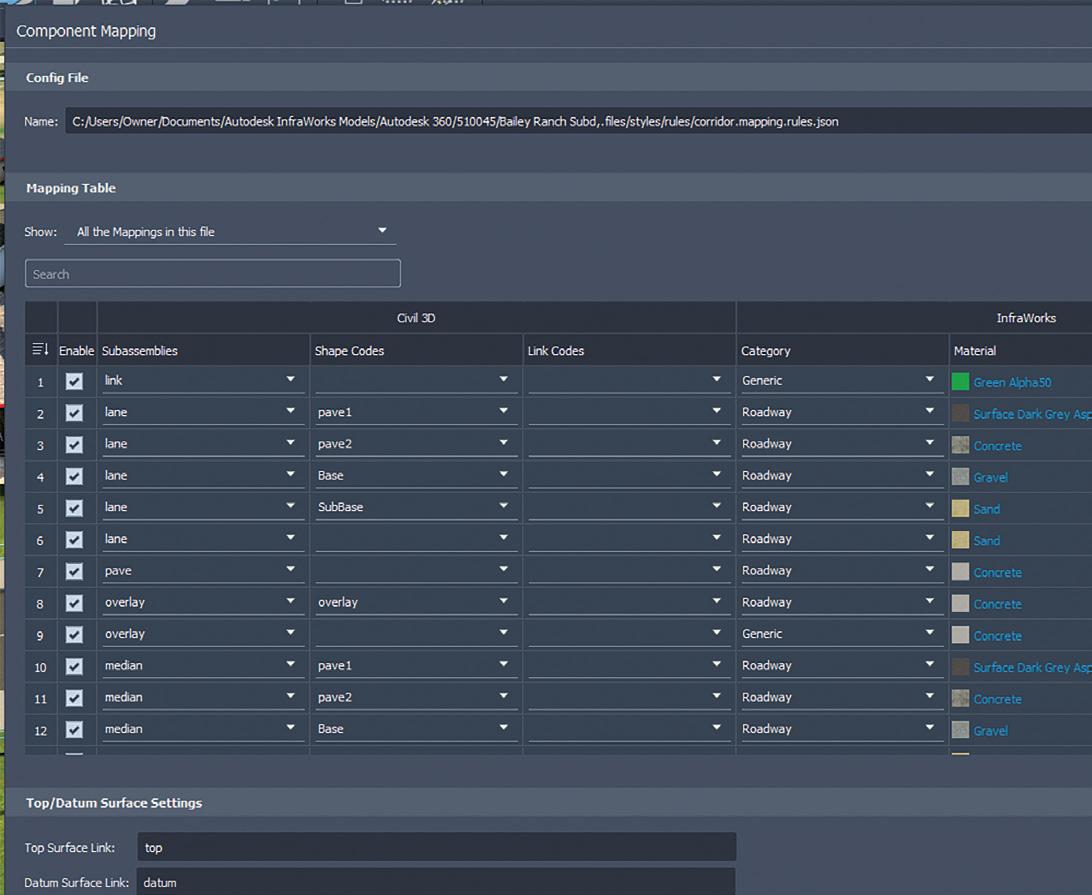
To configure, or re-assign different render materials for each element of the component road, such as lane pavement, curbing and sidewalk, you will need to click the Component Mapping Settings.
To assign a new material, simply double-click on the material type for the that line to assign the Select Material Style/Color. If you make changes to the road corridor in Autodesk Civil 3D, then updating the InfraWorks component road model is performed simply by accessing the Data Sources panel, right-clicking on the road, and selecting the Reimport options (figures 11 & 12).
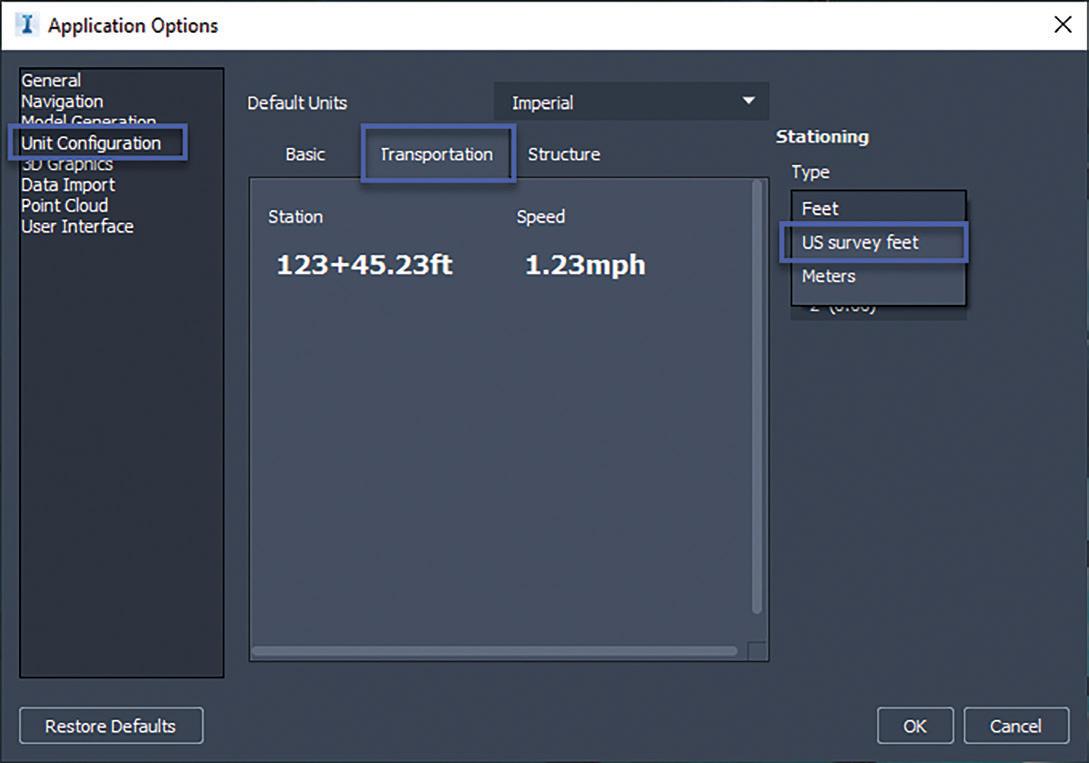
Other additional road improvements include the US Survey Feet option in the Application Options>Unit Configuration>
Figure 10
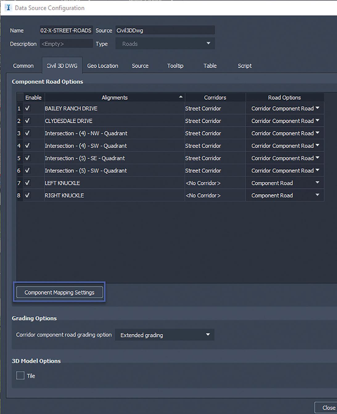

Figure 12
Figure 13
Figure 11 Transportation tab, under Type pull down menu. This addition helps resolve the minor discrepancy between the label and the actual road data (figure 13).
In conclusion, InfraWorks 2021 has greatly improved the collaboration for road corridors and bridges between other design software such as Civil 3D and Revit to create a more accurate and efficient design workflow.
Tony Carcamo is President of Civil CAD Learning Solutions, and COO and part owner of Modern Engineering Solutions in Dallas, Texas. He has 23 years of experience in the civil engineering field performing different task from surveying, platting to full site, utility and drainage design, project management and business development. In addition, he has 12 years of CAD Management experience with several engineering firm. Tony is also a blogger, on most Autodesk committees and council group, president of the DFW BIM Infrastructure User Group, and certified professional in AutoCAD Civil 3D and InfraWorks 360, Autodesk Expert Elite member and member of the Autodesk Service Market Place.


