
14 minute read
FEN TO FELL

from BASE # 02

Story | Chris Hunt Photography | River Thompson
Advertisement
Anyone who lives in a city will know the feeling of having been there too long. The sense of blockage, the longing for surfaces other than glass, concrete and tarmac... - Robert MacFarlane
The story of a four day ride from Holme Fen, Cambridgeshire to Scafell, Cumbria
With my head down, I note the slowing pace at which the white lines beneath my tyres are passing by. We’re edging towards the 100km mark for the day. Having just dropped off a loose gravel trail, I’ve also dropped off the back of our group. We’ve just crossed over the top of Malham Dale in North Yorkshire, the high point of our morning’s ride before descending into Ribblesdale. As we hit the road, I’m glad to be descending once again. Thankful for the effortless speed and the smooth asphalt beneath my tyres, the last remaining glycogen seems to evaporate from my muscles.
The idea High points take all the glory when it comes to cartography. But where was England’s lowest point? None of us had a clue. The crater of a former lake amongst the flat farmland of East Anglia, a few miles south of Peterborough, is in fact home to that somewhat anticlimactic title. Therein lay the outline for our journey: from the lowest to the highest point in England. Whilst the topographical opposites of low and high provided our journey with purpose, riding between them to explore some of the country’s byways was intriguing enough by itself. With noticeably shorter days, morning chill and the occasional falling leaf, sleeping unsheltered beneath the stars after long days on the bike felt like a fitting way to welcome the change of the season. We weren’t out to race, nor to push ourselves beyond our capabilities. The concept for the journey was self-supported, human-powered, and flexible. Escaping the city was a prerequisite, with the notion of gravel singletrack, mountain passes and wild bivvy spots at the forefront of our plans.
To plan our route we’d use Komoot – an experience-based planning and navigation tool and app – which would help us quickly and easily design a route. We could include suggested highlights from other riders, which considering our choice of bikes could be anything from green lanes, challenging mountain passes, or technical singletrack descents. So that’s what we did. With a mixture of mountain biking, gravel paths, cycle touring and classic road riding segments, we had the basis for our adventure: a four day ride from the marshy, low-lying Fenlands of eastern England - home to Holme Fen, the lowest point in the country - to Scafell Pike, England’s highest peak. There’s a romantic simplicity to the bicycle; the freedom and sense of connection it provides is hard to match. There’s also an undeniably human element to it. You’re extremely exposed to your environment when riding a bike. The smallest transformation in your surroundings, the slightest adjustment in gradient, a swing in the wind’s direction or the drop of a few degrees in the air temperature can all impact your time on the bike. I like to think of this as positive vulnerability.
The Fenlands We were off to a shaky start. Arriving from Bristol and London, with a long journey on the motorway and a chain of cancelled trains respectively, River and I eventually met in Peterborough. Final adjustments to our bikes and set ups, and we stocked up on the first day’s worth of food. From here, just a few miles south would see us descend to four metres below sea level, in the centre of the Holme Fen Nature Reserve.
A few hundred years ago, this reserve was the location of Whittlesea Mere, the largest lake in Southern England and home to endemic wildlife including the large copper butterfly. In 1851, the lake was drained to create farmland; today, whilst its surroundings are a mixture of agricultural land and suburbs, the reserve remains a marshy wilderness where bumpy trails wind through the forest.
The removal of the former body of water caused the peaty land to act like a sponge, shrinking significantly as the water drained away. Predicting this effect, William Wells decided to measure the rate by installing a gauge. Despite having gone through several iterations, today the cast iron Holme Posts - erected at what was already believed to be the lowest point in the country - illustrate the level the ground has receded, now standing at about four metres. Between the rolling clatter of passing freight trains, birdsong dominates the soundscape, but the large copper butterfly never returned.
Our ride aligned with the launch of Komoot’s Premium service which, integrated with the latest weather conditions, warned of direct headwinds for the first couple of days riding. Increasing through the day 15-20mph the changing direction seemed to match our every turn. We felt every breath as we rode out of the basin of the former lake, taking turns in the lead to provide respite for each other against the relentless headwind through the flat, exposed farmlands of East Anglia; soon, though, we crossed the border into Lincolnshire.
With self-supported bikepacking, or cycle touring, comes an inherent freedom and flexibility seldom experienced elsewhere. In that vein, while we’d follow our planned route, we’d simply ride until our legs and minds gave up, or we found somewhere simply too good to pass. Setting off with just a few hours of riding ahead of us before dark, dusk descended fast. With the ground quickly dampening under the falling dew, we found ourselves on the shores of Rutland Water. Fed from the River Nene and River Welland, it’s the largest reservoir in England; it felt like a fitting first point to connect to from the eerie remnants of Wittlesea Mere just 60km behind us.
Riding amongst giants Just to the west of Rutland Water, the pretty market town of Oakham provided morning coffee and sustenance in the shadow of its 12th Century castle. From here, the flat exposed roads of the Fenlands felt distant as we weaved our way through short, punchy climbs and descents, across rolling limestone hills, past idyllic villages and imposing Norman castles. In the golden afternoon light, we arrived under the tall pines of Sherwood Forest where we met Rob Marshall from Komoot, who’d join us for the following couple of days. By this point we were about 90km in and our legs and minds felt weary. But a new release of endorphins provided by the dusty, winding single-track and with a fresh injection of energy added to the group, our grins stretched wide as we tested the capabilities of our gravel bikes. Having ridden miles of fairly nondescript roads and lanes, the contrasting scenery was refreshing and the new dynamic of an additional rider quickly granted a boost for our tiring legs. Rob had timed his joining up with the ride to perfection.
As we progressed north the skies darkened, and sure enough the threat of rain transformed into a torrential downpour as we crossed the border of Nottinghamshire into South Yorkshire, and, before long, the surreal Yorkshire Sculpture Park; an outdoor collection of giant artwork.
The waterways of the North As the last of the evening’s hazy golden light threatened to dip beneath the surrounding hills, we ascended from the upper reaches of the Chesterfield Canal, over the corn fields between combine harvesters. We felt a little too close to the bright lights of Sheffield to find an undisturbed wild camping spot. On Komoot’s mobile app, we checked what remained of our route that evening. Ulley reservoir was the obvious spot to aim for, so we grabbed our supplies for the night, added the reservoir to our route on the mobile app, and got back on the road. Now armed with a small bottle of Glenfiddich’s finest and a full day of riding in our legs, we were confident we’d sleep well despite our proximity to Sheffield and Rotherham.
When morning rolled around, our weary trio pedalled through the traffic into Rotherham, jarred by the juxtaposition of finding ourselves in the centre of a city. We then edged our way past the industrial hubs of South Yorkshire before winding onto the Leeds and Liverpool Canal. The longest in Britain, the canal was built to connect the two cities in the mid-18th Century to enable the increasing trade between the growing cities of Yorkshire. It took almost 50 years to complete, and by the 1860s over a million tons of coal a year was being delivered to Liverpool. The gradual, continuous ascent provided easy miles across the southern Pennines, and delivered us to the edge of the Yorkshire Dales. God’s own country As soon as we turned off the canal, we faced our first proper climb of the trip so far - although in theory we’d been gradually ascending since we set off from Holme Fen. Leaving behind the old mill buildings of the town of Silsden, we traded the gravel towpath for rolling lanes lined by lichen covered dry stone walls as our views opened to the Yorkshire Dales National Park.
From here, sheep shit dominated the afternoon. By the end of a good day’s ride, brushing off the mix of dried mud, poo and dust from our water bottles we felt like extras from a budget rendition of an Indiana Jones film.
As the light killed the definition in the road ahead, we passed through the surrounding forests of Bolton Abbey and reached the banks of the River Wharfe, where we once again chose our bivvy spot. Navigating our way down the steep, rocky tracks through the forest we passed our bikes down to each other as we descended to the riverside.
Sleeping outside in wild places, with the focus of a fire and warm food at the end of the day, offers a valid reason for cycle touring in itself. Here, we had enough shelter against the descending dew from a large-leafed oak tree; the partially collapsed dry stone wall and building foundations to our backs suggested a region of busy farmland in the past. We inflated our mattresses and laid out our sleeping bags for the night. Between the sporadic cloud, the darker skies of our rural surroundings offered fleeting glimpses of what remained of the Epsilon Perseids meteor shower.
That next morning I woke with the warm breath on my forehead as a dog made its way around our camp, sniffing our respective bivvy set ups; two of them, including my own, were still occupied. We slowly rose, gathering our kit whilst pondering the ability of ultra-endurance athletes to do this day in, day out. After a while, we watched in perfect silence as two deer edged their way into the cold rush of the river, attempting to cross. This was the escape we’d been after.
Whilst Section 30 of the Countryside Act (written in 1968) permits the riding of bicycles on public bridleways, that same act also specifically states that it ‘shall not create any obligation to facilitate the use of the bridleway by cyclists’. Interpret that how you will; but the bridleways we’ve followed past the limestone crags, caves, and stonebuilt ruins of the Yorkshire Dales National Park felt like the perfect match for the adventure-ready gravel bikes we were riding. Following miles of dry stone walls, the rolling hills of the Dales provided slow but engaging progress on loose gravel tracks and grassy bridleways.
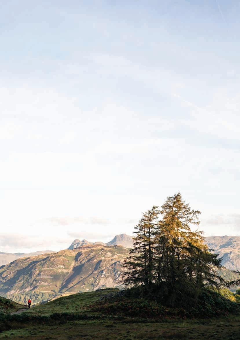
Heading northwest, with the wall of the Lakeland fells rising on the horizon, we descended from the Dales with the ominous peaks of Cumbria lying dead ahead of us.

Sheep shit dominated the second afternoon; we felt like extras from a budget rendition of an Indiana Jones film


The Lakeland fells With muddy moorland trails behind us, the speed of winding and fast-descending tarmac took us in good time towards Kendal, as I attempted to restore my blood sugar levels and empty legs, in the hope of a late afternoon injection of caffeine. This was also where Rob would leave us, as Kendal was the last option for a direct train back to Manchester.
We soon found our way to Ye Old Fleece Inn, the town’s oldest pub. Sat out on the street in the last of the day’s sun, coffee and potatoes drenched in cheese made their best efforts to encourage us back on the bikes for the final run into the Lakes.
We’d heard stories of people riding at least part of the way up Scafell Pike. But we’d also heard rumours of riders being practically laughed off the mountain by hikers as they tried to fight the crowds pushing a bike. While I had mapped a route to the top using Komoot, it came with strong warnings of long hike-a-bike sections, and with other substantial sections categorised as ‘unknown terrain’. We fly the final 10km to the Hawkshead YHA where we had beds booked for the night. The peaks surrounding Lake Windermere brought a premature sunset as we pressed deeper into Cumbria, with the high country of the Dales basking in gold behind us. We arrive just minutes before the kitchen closes for the night, and settle in. Holme Fen now felt a long way south as we considered the diagonal line we’d stamped across the map over a couple of locally brewed IPAs.
With aching knees and dehydrated bodies, we woke to our 5am alarm to repack our saddle and bar bags for a final chance of scenic off road trails before we started the long journey back south. The only chance of a connecting train into London was at 2pm from Kendal, so we were keen to make the most of our final morning in the wild before heading back to busy urban lives. Competing with hikers on the region’s most popular peak with loaded bikes on our backs seemed less appealing, though, than some real local exploration. So instead of battling with the hikers on Scafell, we opted instead to ride a couple of much quieter nearby trails.
We pedal out under a barely risen sun. A low mist is draped over the valley between lake and peak as the early

chill wraps around our knees and stings our knuckles. Across slippery slate bridleways with views over the surrounding fells, we descend towards the base of England’s highest mountain where we plan to take an icy plunge into the country’s deepest natural lake, Wast Water (74 metres at its deepest point).
Later, as we navigate our connecting trains towards home, we have plenty of time to ponder the past few days. Most of all, we’re reminded of the intrigue and sense of occasion that comes with adventure on two wheels. On some level, almost everyone connects with bikes, whether it’s a nostalgia from riding as a child, or because they regularly ride 100km on Sundays, or because they know someone whose enthusiasm for the bike renders it a worthwhile pursuit. On this trip, we’d zig-zagged across England, traversing a wide array of different
landscapes in a short time; lowland forests, the suburbs of big cities, the remnants of the industrial past, rolling rural farmland, the high country of North Yorkshire, and finally the epic drama of the Lake District.
At each connecting point of the rail journey home, we were asked by someone about where we’d been, what we’d been up to, and why. Whatever the reasons for our ride, the sting of our windburnt cheeks, chapped lips and fatigued bodies felt like a worthy exchange for the real adventure we’d had, and for the cold beers now in our hands.
Thanks to Mason Cycles for providing their latest InSearchOf and BokehTi bike models, and to Apidura for supplying a complete bikepacking luggage system for this adventure.
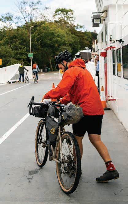
FACING PAGE LEFT: As night begins to fall, a diversion in the route for food or shelter is usually called for. With the Komoot mobile app, incorporating this into your ride is simple. FACING PAGE RIGHT: The north shore of Rutland Water was the perfect bivouac spot. THIS PAGE LEFT: Old factory structures along the Leeds and Liverpool canal. THIS PAGE RIGHT: The first cable ferry across Lake Windermere in Cumbria commenced operation in 1870. A century and a half later, the current ferry, the Mallard, shaved off a cool ten miles from our route.

