9 minute read
Master Plan Studio


2. Master Plan studio
The studio focused on preparing Master Plans for large green field developments in peri-urban areas. To respond to the demand of expansion in the rapidly growing urban centers, governments facilitate such new developments through various development mechanisms.
Advertisement
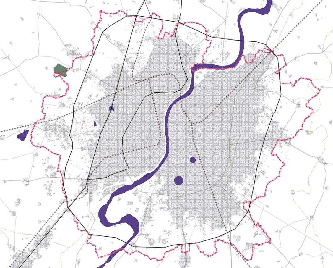
The proposed site is situated in close proximity to the existing SP Ring road and the proposed 90m outer ring road. The upcoming DMIC corridor is thought to have a significant impact on urban morphology in the next 20 years.
Site
Towards Gandhinagar
Sarkhej - Gandhinagar Highway
Sardar Patel Ring Road
Towards Vadodara
In the proposed DP scheme, the interconnecting 36m wide road would act as the entry gateway to the site and links to the 45m wide road feeding onto the highways, opening up multiple opportunities. This forms the context of the site.
Proposed 90m Ring Road Proposed 45m Road

36m Proposed Road 36m Proposed Road Sardar Patel Ring Road
0
Proposed Road Network 1km
Here is a mapping of the commercial and industrial activities presently going on in the site is surrounding context. The Gamthal areas to the north of the site are concentrated with industrial activities, such as pharma companies and food processing units. Bhadaj gam is located very close to the site, with industrial activities. Commercial activities are observed close to the Sola road junction and along the SP ring road. The southern parts of the precinct are dotted with minimal commercial functions.

Hospital
Education Institiution
Public Place
Science City Campus Cricket Grounds
Micro Level Public Spaces
The location advantage of the site with respect to the city, a new township at this site possesses significant assets for a better lifestyle like potential entry based on the DP Road and interactive edge.Impactive nodes reflect the direction of development of the green field site.
Potential Entry Road Impact Nodes Interactive Edge

Adopting Green Urbanism as a tool to develop an integrated township in order to achieve a neighbourhood with equitable greens.
Connectors


Build Density

This blue-green forest is the core facilitator for the microclimate, breathing lungs, catchments and micro water ecosystems for the township. To enhance the positive effect on climate, micro-level green lungs are created across the robust grid framework, forming perimeter blocks with central green islands. To activate the green ecosystem through interlinked functions, the interweaving of the green lungs in macro to micro-level is done. The mixed-use public zone is very important to the township. The placement is done along the axis of cross over infrastructure, making the township functionally integrated based on green urbanism.
Forming the rationale behind the creation of the axes. The connector network is integrated accordingly forming a robust grid is framed on it, which is tweaked to create an unbroken green belt. Secondary axis is provided parallel to 35 m proposed DP road. The parcel is provided with the commercial zone. These are the major connectors provided across the township
High rise high density structures are placed on the periphery of the open space and the edges on the site. Remaining spread is distributed as mid rise buildings which comprise of residential towers. On the periphery of the site, there is low rise low density, where the individual bungalows are positioned.
Legend:
Hig-rise Build Densitry
Mid-rise Build Densitry

Indvidual Residential Block Individual residential bungalow typology building is placed with a neighbourhood open plaza as the spine.
Insitutional Zone The area along the lake edge is created as an institutional zone and is integrated with the green corridor.
Mixed-Use District High rise block placed on the periphery of the open space which is facing the township level open space.
Residential Block The mid-rise apartment typology building is placed with a neighbourhood open plaza as the spine.
Shopping Mall Urban forest connected with the commercial zone that can be connected with the shopping mall
Commercial District High-rise commercial district.
IT Corridor IT corridor is placed on the edge of the SG Highway. The proposed master plan highlight the vision of a vibrant community achieved through various aspects. This 300-acre development offers a wide variety of housing choices, retail and cultural facilities with employment opportunities, an urban school, and a 60-acre green corridor act as urban living room. An expansive public realm program weaves together a unique fabric of residences, offices, shops, restaurants, civic uses that inculcate the habit of healthy living by enhancing microclimate and improved air quality. The township’s unique areas are created by a strong connection framework and valuable assets. Where buildings are arranged to maximise vistas and create landmarks inside the district. The township’s broad spectrum of urban environments is characterised by a variety of typologies, density, and open spaces. The existing terrain informs the character of the zones, resulting in four districts. Each district provides for a great deal of freedom in terms of the kind of programs and services available.
This green corridor acts as the focus of the development and provides an iconic green space for all residents, works and visitors of the township.The second landscape feature that defines the master plan is a pedestrian spine that majestically weaves the community spaces of all the districts together, providing a stunning foreground for development. Each of the zone offering diverse programs which is open to all groups. Vibrancy can be found in multiple forms of runways, such as the bicycle and pedestrian runways throughout the spine, a playground, a children park, sports facilities.

Legend:
Urban forest connected with the commercial zone could be connected with shopping mall. Green forest connected with the mixed use block with amenities like parks, community hubs. The green spine runs in the neighbourhood level with the commercial edges and transitional zones in the edges of the residential block.
Green forest connected with the residential block with amenities like parks and civic center. Green forest connected with the institutional block’s with amenities like sports hubs and amphi-theater.
Where, we have segregated the buildings based on the density. High-rise high density is placed on the periphery of the open space and the edges on the site. Remaining spread is distributed as mid-rise buildings which comprise of residential towers. On the periphery of the site, there is low-rise low density, where the individual bungalows are positioned.

High-rise: Buildings abutting the open space and cross over infrastructure should not exceed 60m in height (20 Floors). Mid-rise: Buildings in the residential block and inside the neighbourhood block should not exceed 30m in height (10 Floors). Low-rise: Buildings abutting the open space and cross over infrastructure should not exceed 9m in height (3 Floors).
Entry Entry

Entry Points
Its a transitional zone like a market hub, street vendors will lend things will happen in this zone . People from the neighbourhood access the zone and buy daily needs
Key Plan
Mixed use build typology Ground and 2 floors acts as a commercial or retail typlogy .remain floors act as a residential tower.

A childeren park with walking trails which allows different sset of activiites like cylcing ,joging,playing etc
Residential Tower facing the open space in the center Residential District block has the commercial edges on the and residential edges interact with the green spine runs in the neighbourhood level. The commercial parcel has retails in g+3 floors with residential space in above floors. 4bhk and 3bhk apartment along block level and 2bhk along rear end.
Mixed use Building facing the urbanf forrest open space .
Entry From the arterial road to the residential district.
Green shades provided on the edges of the street

Green Spine followed in the whole stretch along the middle of the residential districrt
Cycling track on the either sides of the green spine
Mixed use build typology Ground and 2 floors acts as a commercial or retail typlogy .remain floors act as a residential tower.
In a transitional zone like a market hub, street vendors will lend things will happen in this zone . People from the neighbourhood access the zone and buy daily needs. Anchoring point where the elemnt act as nodal juntion of the 4 block .
Green Spine runs from the open space has multiple activies in the every zones.


Green Forest connected with the institutional Blocks with amenities like Sports hubs and amphi-theater.
Key Plan
2m Pedestrain path way edge

Parking edge with green buffer every 2m
Cycling track
2m Pedestrain path way edge
6m plot edge open to the public space
Mixed use Building facing the urbanf forrest open space . The block’s particular orientation, which “welcome” the forest aesthetically onto the site, increases the amount of building faces with views of the forest. The midrise residential buildings along the open space have been strategically placed to optimise views from buildings further back from the forest and to provide a low-scale experience of the structures fronting onto the urban forest Park. The ground level of this 30-meter thoroughfare has a lively retail edge, as well as a broad pedestrian walkway with various outside activities such as cafés. To prevent conflicts, a 2.5-meter dedicated lane for public transportation is provided.
Green Forest connected with the institutional Blocks with amenities like Sports hubs and amphi-theater.
Cycling Track
6m plot edge open to the public space

Cycling Track
Parking lane Mixed use Building facing the urbanf forrest open space .
Green Forest connected with the institutional Blocks with amenities like Sports hubs and amphi-theater.


The Urban Block will feature a healthy mix of uses, with busy street uses on the bottom level and a mixture of three residential blocks, each of which is extremely adaptable and incorporates changeable flat types. The clearer shape, ordered placement of buildings, readable roadways, and layout of the township allow inhabitants to create an accurate mental map of their neighbourhood and the township as a whole. Runs the length of the property, connecting the central spine, plazas, and streetscape to encourage a healthy living and human sized environment.

Set Back
All buildings should maintain 6m on all sides of the parcel.


Streetscape
There shall be continuous street tree canopy and water management landscape along the primary streets.

Ground Floor use
Ground and First floors of the residential towers should have commercial mixed-use for activating the road.
Build Typology
The building parallel to public open space shall have podium structures where the building has commercial use on its ground floor.

