Downtown Charleston Transit Study
Downtown Network Concepts


CARTA and BCDCOG are working on changes to local bus and DASH shuttle service on the Charleston Peninsula to:
1. Enhance service frequency, access reliability, and coverage;
2. Modernize transit infrastructure; and
3. Regain ridership post-pandemic and build new ridership.
This document contains draft concepts for future transit networks that were created based on current transit demand, planned developments on the Peninsula, ridership trends, on-time performance, fleet constraints, and community input to date. Additional considerations involved transit infrastructure on the Peninsula including:
• Planned Mt. Pleasant Street park-and-ride lot;
• Proposed Lowcountry Rapid Transit (LCRT) alignment and stations and corresponding infrastructure; and
• Access to existing and planned bicycle and pedestrian facilities.
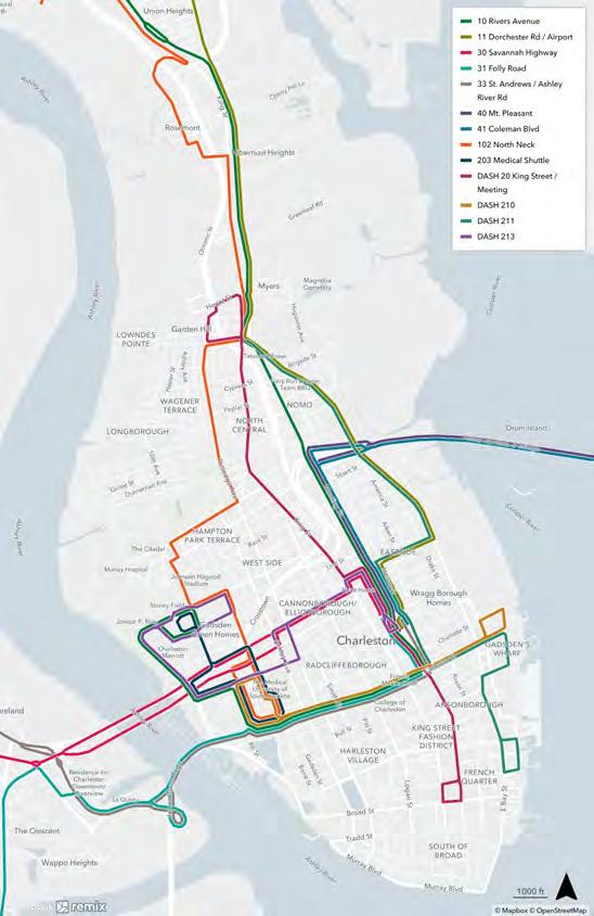
The map to the right shows the Study Area and the existing downtown bus network. The Study Area includes the portion of the City of Charleston on the Peninsula, terminating at the northern city limits. Local routes and Downtown Area Shuttle (DASH) routes are shown on this map, but express routes are not. Express routes will be shown on a separate map within the document.


CARTA and BCDCOG are also working on the Lowcountry Rapid Transit (LCRT) project, a bus rapid transit route that will connect from Ladson to the Peninsula. As the LCRT begins operating, it will need to be integrated with existing routes on the Peninsula. In anticipation of the LCRT service, two network concepts were developed:
• "pre-LCRT" (short-term changes before LCRT begins operating)
• "post-LCRT" (updates once it is running).
The maps to the right show the proposed network before and after the LCRT is operating, as presented to the public in February/March 2024. Pre-LCRT changes are proposed for Routes 10, 11, 30, 41, and 102. A few local bus routes would change again after the LCRT begins operating, including Routes 10, 30, 102, and Route 203 (Medical Shuttle).
In general, the proposed networks attempt to provide as much bidirectional services on corridors as possible and consolidate more services onto Meeting Street and Calhoun Street. These guiding principles are based on public feedback noting the desire for more frequent service and transfer opportunities on a few corridors downtown.
The proposed changes will not affect where buses run beyond the Study Area. When bus frequency (how often the bus comes) or service span (hours of operation) changes are proposed, those would be made for the entire route, including the portion beyond the Peninsula. Route frequency and service span changes are noted in the final concepts section.
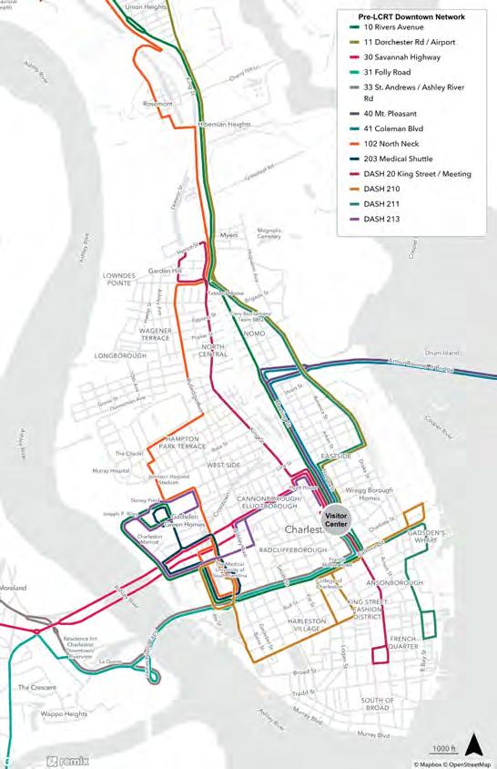
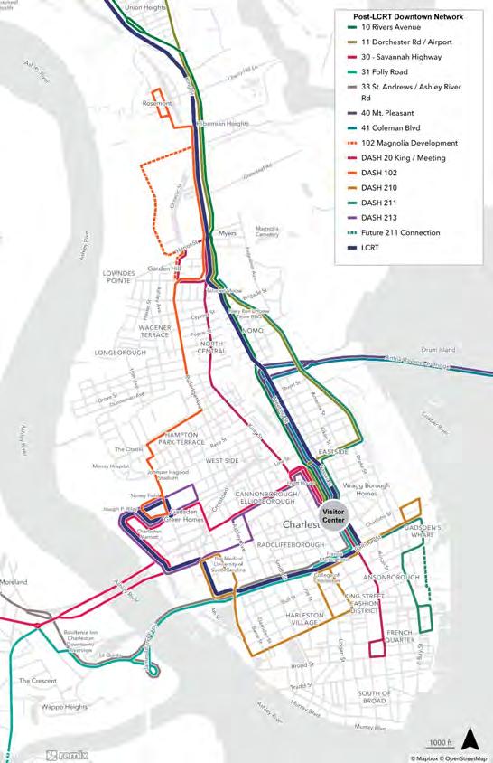
This section provides more details on the route alignment changes for each route in both the pre-LCRT and post-LCRT downtown network concepts proposed and presented to the public in February/March 2024. For each route, there is a short description of the current services provided on the Peninsula and descriptions of the changes, as applicable.


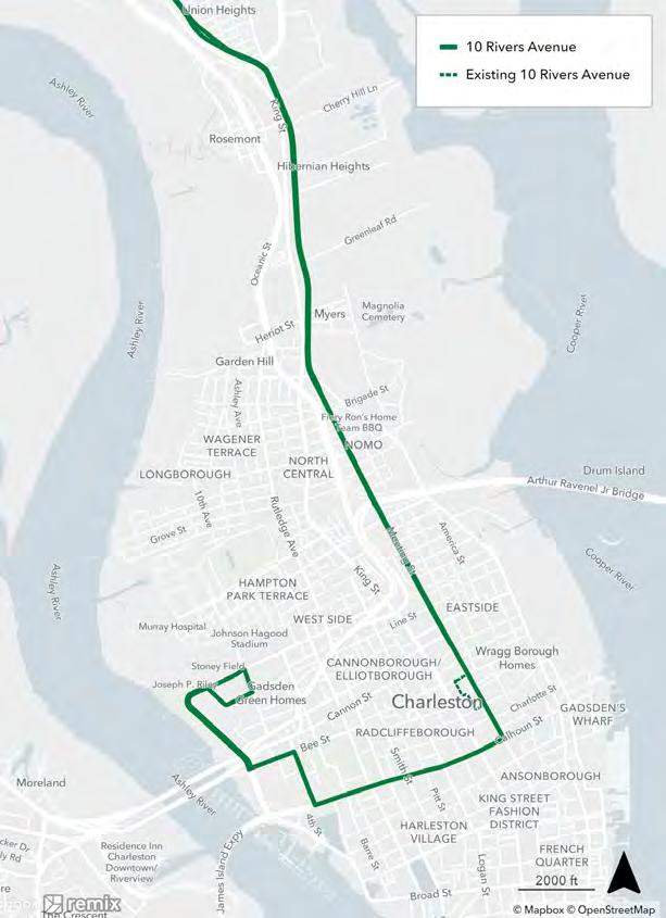
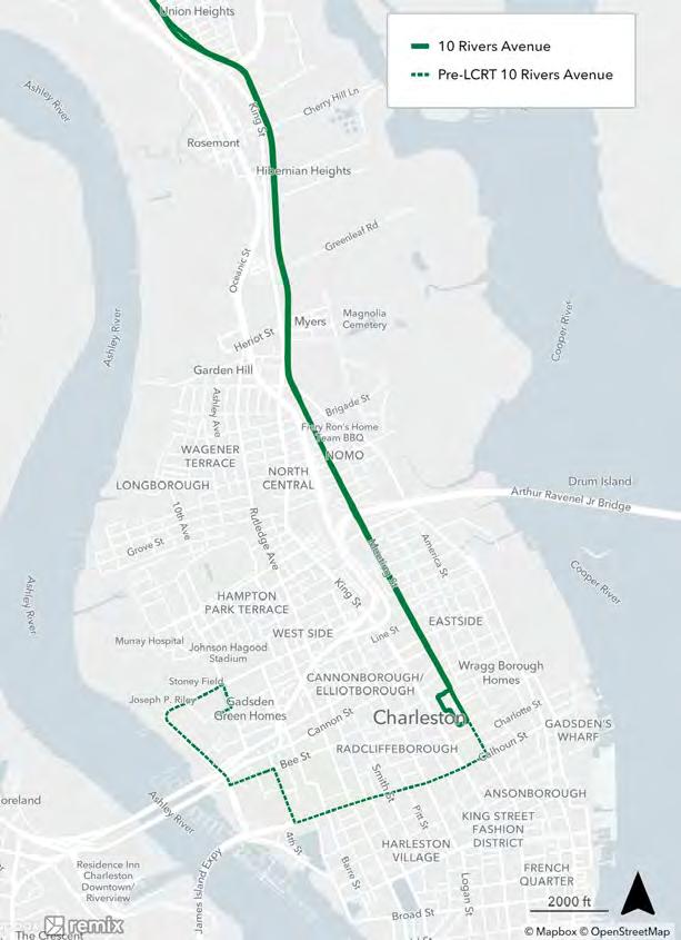
Existing: Route 10 runs along Rivers Avenue and Meeting Street from Trident Medical Center to the Visitor Center.
Proposed (Pre-LCRT): Route 10 would still run along Rivers Avenue and Meeting Street, but it would continue past the Visitor Center to the WestEdge development and Medical District via Calhoun Street, ending at the Hagood Lot at Hagood Ave and Line Street. This extension follows the same route as the planned LCRT service and provides access to the Medical District without transferring at the Visitor Center. An additional bus would be added to maintain the existing frequency.
Proposed (Post-LCRT): Once the LCRT is operating, Route 10 would revert back to its current route, ending at the Visitor Center. CARTA will be evaluating all routes that travel outside of the peninsula as part of a separate study to identify what changes will be needed when LCRT begins operating.

Existing: Route 11 connects the Charleston International Airport to the Peninsula. On the Peninsula, it runs along Meeting Street to Morrison Drive, turns onto Columbus Drive and heads down Meeting Street toward the Visitor Center. From the Visitor Center, it goes along Mary Street and America Street to loop back to Morrison Drive heading north.
Proposed: Route 11 would mostly stay the same in the proposed concepts. The only change would be to use Columbus Street and Meeting Street in both directions before terminating at the Visitor Center. This bi-directional service is more intuitive and makes it easier for people to understand where to find Route 11. Route 11 would no longer run on Mary Street (Meeting Street to America Street) or America Street.
Post-LCRT recommendations will be identified in a separate study.


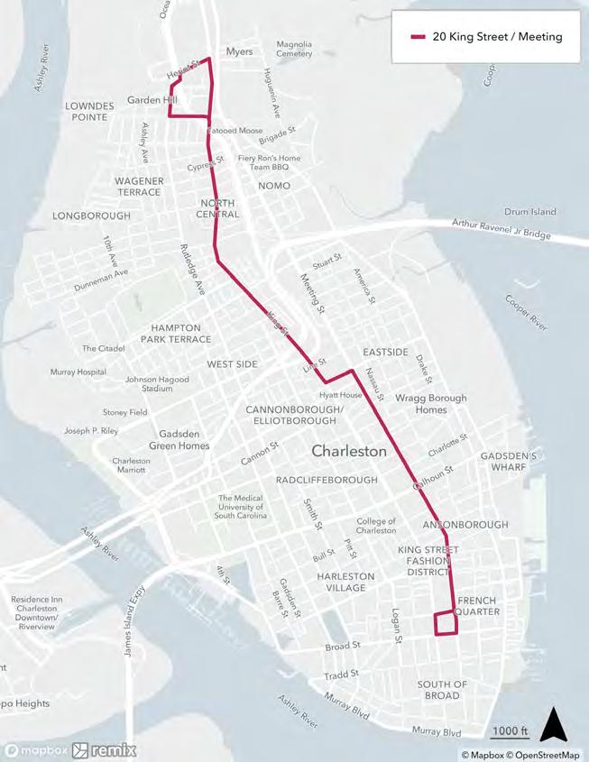
Existing: Route 20 runs north-south through the Peninsula from Montford Avenue to Broad Street. It uses King Street north of Columbus Street, then shifts over to Meeting Street to the south.
Proposed: The proposed Route 20 essentially maintains the existing alignment, terminating a few blocks farther north on Heriot Street and connecting to the planned location of the new Mt. Pleasant Street parkand-ride lot. It would be reclassified as a DASH route. Route 20 is free today and would remain free as a DASH route.
There are no additional proposed changes to Route 20 after the LCRT is operating.

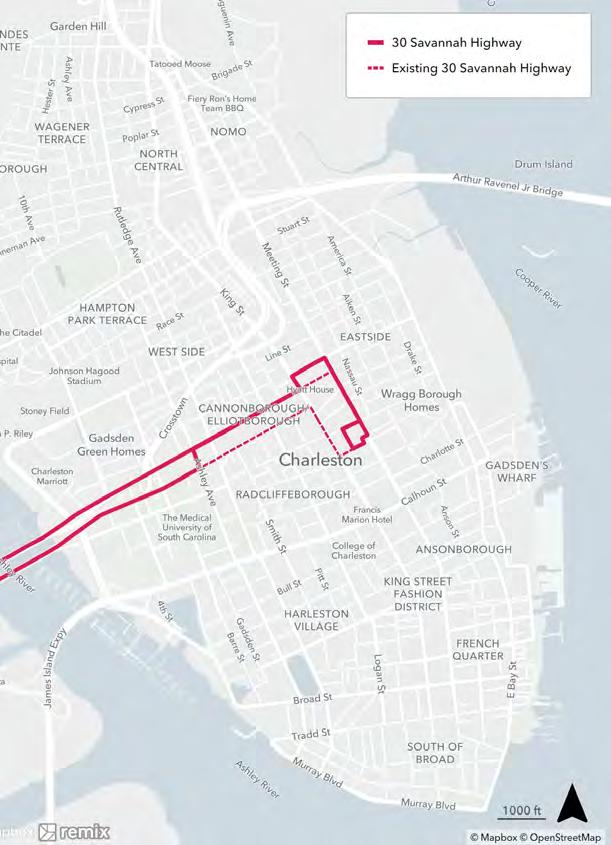
Existing: Route 30 connects the West Ashley area to the Peninsula. On the Peninsula, it runs eastbound on Cannon Street, turns right onto King Street, and loops around the Visitor Center at Ann Street. Heading westbound, it goes up Meeting Street to Spring Street and back toward West Ashley.
Proposed (Pre-LCRT): The proposed change keeps Route 30 on Spring Street as much as possible to provide easier to remember, bi-directional service. One-way pair service on Cannon Street and Spring Street would be limited to west of Ashley Avenue due to the one-way bridges over the Ashley River. Near the Visitor Center, the new route uses Meeting Street to take advantage of traffic signals to make turns easier and to have fewer interactions with King Street.
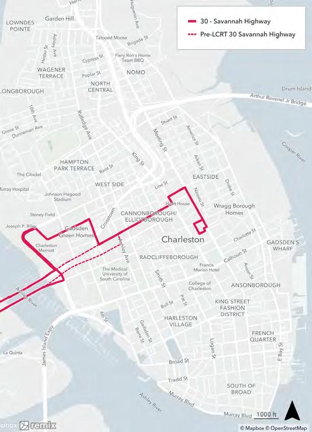
Proposed (Post-LCRT): After the LCRT is operating, Route 30 would be rerouted just east of the river via Lockwood Drive to connect to the end of the LCRT line at Line Street and Hagood Avenue. From there, it would turn onto President Street to get back to Spring Street and head to the Visitor Center.

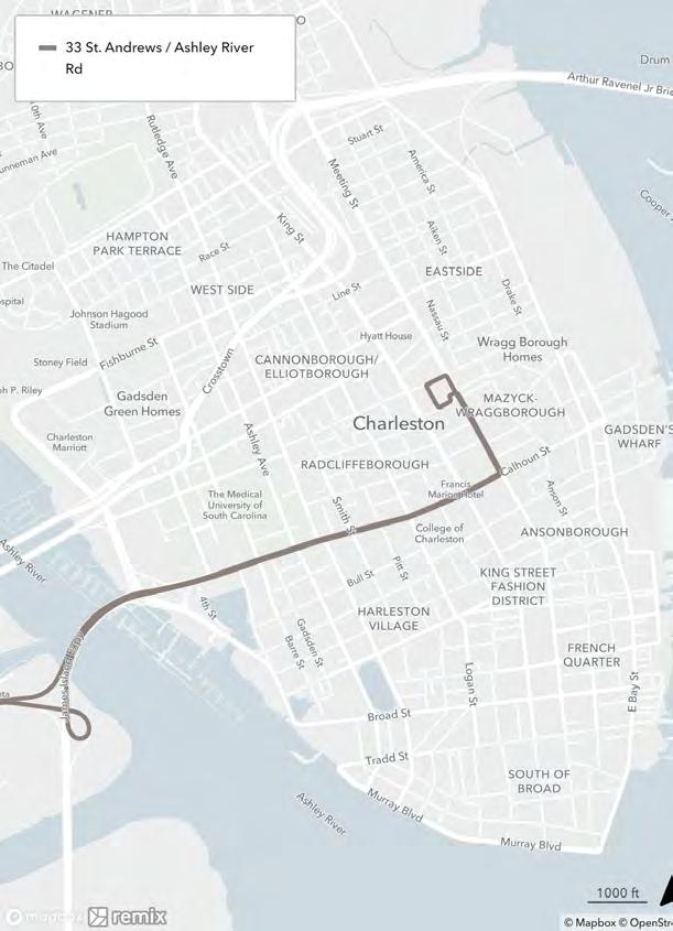
Existing: Route 31 connects James Island and Folly Road to the Peninsula. Route 33 connects West Ashley via Ashley River Road. Both routes access the Peninsula via James Island Expressway and Calhoun Street to Meeting Street and loop around the Visitor Center at Ann Street.
Proposed: The proposed network keeps Routes 31 and 33 the same. These routes already serve major employment areas and make connections at the Visitor Center.


Existing: Route 40 connects Mt. Pleasant to the Peninsula via Highway 17 and the Arthur Ravenel Jr. Bridge. On the Peninsula, it runs along Meeting Street and loops around the Visitor Center.
Proposed: The proposed network keeps Route 40 the same. This route already makes connections with other routes along Meeting Street and at the Visitor Center.


Existing: Route 41 connects Mt. Pleasant to the Peninsula via the Arthur Ravenel Jr. Bridge. On the Peninsula, it runs along Morrison Drive to Columbus Street and loops around the Visitor Center on Meeting Street, Morris Street, and America Street, heading back toward Mt. Pleasant via Morrison Drive and the bridge.
Proposed: The proposed changes to Route 41 would shift it onto Meeting Street on the Peninsula, still ending at the Visitor Center. This would simplify the route and make more connections with Routes 10, 11, and 20 north of the Visitor Center.


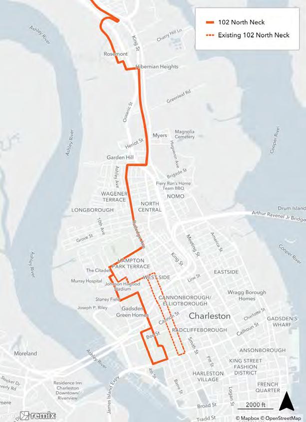
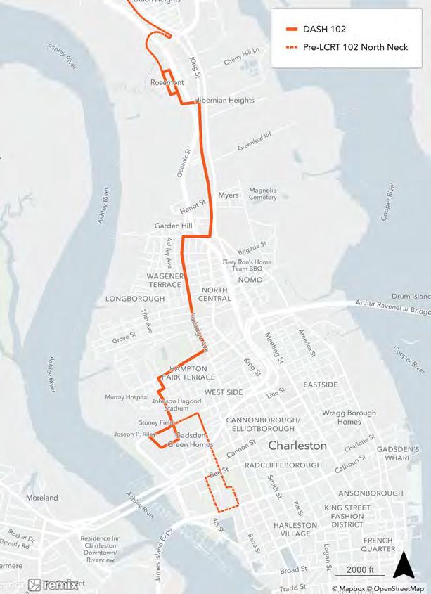
Existing: Route 102 connects the Charleston Neck neighborhoods to the Medical District on the south end of the Peninsula. It runs along King Street to Mt. Pleasant Street, turning onto Rutledge Avenue and through the Hampton Park Terrace neighborhood, heading south on Rutledge Avenue to Calhoun Street and turning back north via Ashley Avenue (a one-way pair).
Proposed (Pre-LCRT): The northern end of Route 102 would remain the same, with route adjustments in the Hampton Park Terrace neighborhood to give more direct access to the Citadel, Gadsden Green Homes, and the Medical District. It would use fewer one-way streets, shifting to President Street, Jonathan Lucas Street, and Courtenay Drive around the Medical District.
Proposed (Post-LCRT): After the LCRT is operating, Route 102 would be shortened and would only run from the Rosemont area to the Medical District, ending at the Line Street/Hagood Avenue LCRT station. Any future connections for the northern portion of Route 102 into North Charleston would need to be studied further. Once the Magnolia mixed-use development on the north end of the Peninsula is complete, Route 102 would shift west in that area to go through the new development. In the postLCRT scenario, it is recommended that Route 102 become a free-to-ride DASH route.

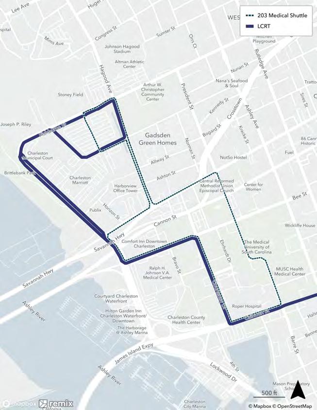
Existing: Route 203 serves to MUSC campus, looping between the MUSC parking lot on Fishburne Street, around the MUSC campus, and down to Calhoun Street.
Proposed (Pre-LCRT): There are no proposed changes to Route 203 before the LCRT is implemented.
Proposed (Post-LCRT): After the LCRT is operating, Route 203 would be replaced by the LCRT. The new LCRT route will have more frequent buses that will provide the connection between the MUSC parking lot on Fishburne Street and the MUSC hospital buildings toward Calhoun Street.

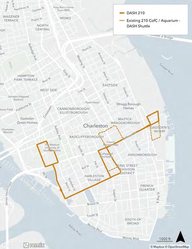
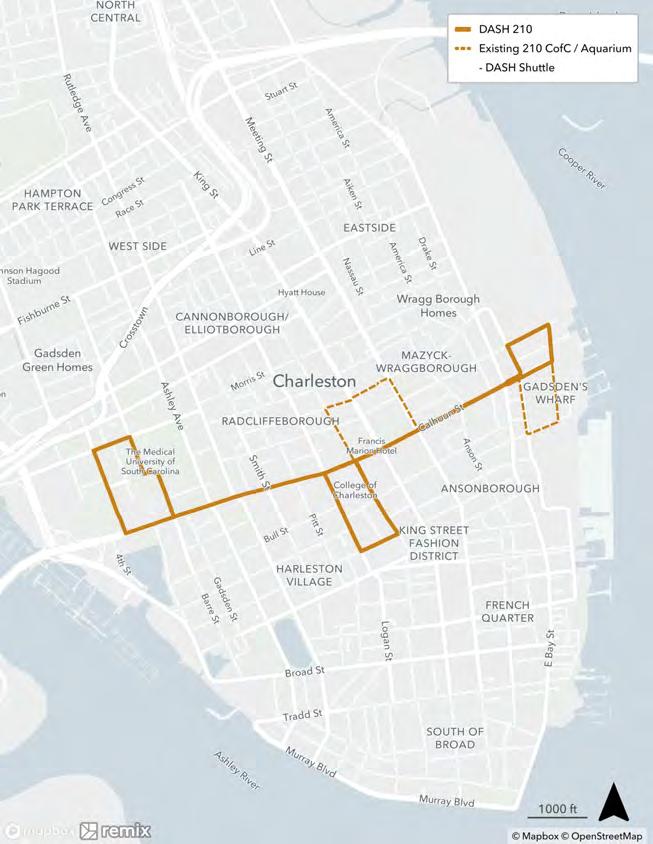
Existing: The DASH 210 loops around College of Charleston (CoC), loops around the Visitor Center, and goes down Calhoun Street to loop around the South Carolina Aquarium.
Proposed: The proposed DASH 210 would extend west through the Harleston Village neighborhood along Beaufain Street and up to the Medical District. Between the College of Charleston and the aquarium, it would stay on Calhoun Street instead of going to the Visitor Center.
There would be no additional changes to DASH 210 after the LCRT is operating.

Existing: DASH 211 runs from the Visitor Center area to the French Quarter as a directional loop on Meeting Street, King Street, Broad Street, East Bay Street, and Market Street.
Proposed: With Route 20 rebranded as a DASH route in the future, it would cover the DASH connection from the Visitor Center to the French Quarter. This frees up DASH 211 to focus more on the east side of the Peninsula. The new DASH 211 route would run from the Charleston City Market in the French Quarter, up East Bay Street and Calhoun Street to stop by the Visitor Center on Meeting Street, and then take Columbus Street back to East Bay Street. It would terminate at the proposed park-and-ride lot at Mt Pleasant St and connect with new developments on East Bay Street.
There would be no additional changes to DASH 211 after the LCRT is operating.


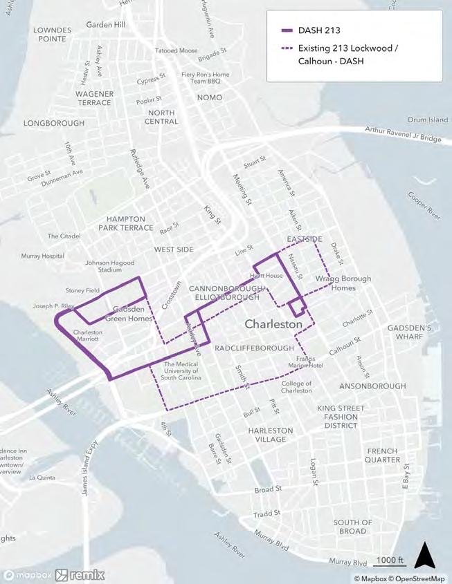
Existing: DASH 213 is a one-way loop between the Medical District and Citadel areas and the Visitor Center. The route uses many streets, and it can be hard to remember where to catch it. From the Visitor Center, it loops around Mary Street, America Street, Columbus Street, and Meeting Street and heads south toward Calhoun Street, west on Calhoun Street to the Medical District, north on Courtenay Drive to Bee Street and Lockwood Drive to the southern edge of the Citadel. Then it takes Fishburne Street, President Street, Cannon Street, and King Street back toward the Visitor Center.
Proposed: The proposed DASH 213 route is simplified and bidirectional, connecting to similar destinations but sticking to fewer streets to make it easier to remember where the route goes. It would run from the new LCRT station at Hagood Avenue/Line Street south on Lockwood Drive to Bee Street through the Medical District, north to Spring Street and over to the Visitor Center using the signalized turn at Columbus Street and Meeting Street.
There would be no additional changes to DASH 213 after the LCRT is operating.

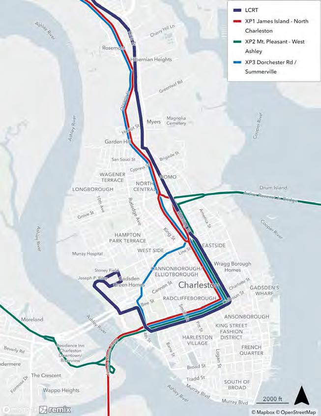
There are no proposed changes to any of the express bus routes that serve the Peninsula:
• XP1 (James Island - North Charleston)
• XP2 (Mt. Pleasant - West Ashley)
• XP3 (Dorchester Road - Summerville)
While alignment changes were not considered for the express routes, blocks of increased service hours were reviewed by the public in the route concept survey.
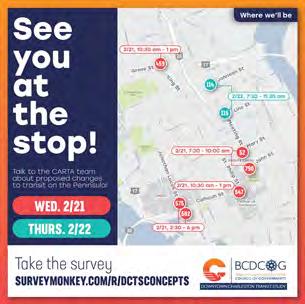
A public survey was developed after the drafting of the two initial downtown network concepts to gather feedback from riders and the community. In-person events were also held at multiple bus stops across the peninsula to gather direct rider feedback and distribute the survey. This section provides an overview of the survey results while the all of the results can be viewed in the “Draft Concepts Survey Results” document.


Open February 14 – March 14, 2024

512 Respondents
• Number of respondents vary by question
28 Questions
• 1 bot filter
• 18 network and route questions
• 8 background questions
• 1 contact information question
Typical time spent: 7 minutes
Respondents were allowed to skip questions for routes they did not have opinions about





Most respondents supported all the proposed pre-LCRT local bus route changes (71% to 85%)

Adjustments to consider
Route 30 Savannah Hwy (Pre-LCRT)
Route 11 Dorchester Rd / Airport (Pre-LCRT)
Route 41 Coleman Blvd (Pre-LCRT)
Route 102 North Neck (Pre-LCRT)
Reevaluate flooding issues at Fishburne and Hagood
Route 10 Rivers Ave (Pre-LCRT)
Reevaluate flooding issues at Fishburne and Hagood
While respondents liked 3 of 4 proposed post-LCRT changes overall, approval ratings were lower than for pre-LCRT changes. This was typically due to a lack of understanding of the planned LCRT frequency and a desire to avoid transfers.

Route 102 North Neck (Post-LCRT)
Route 10 Rivers Ave (Post-LCRT)
Route 30
Hwy (Post-LCRT)
*Respondents either like the proposed route or say they will switch to LCRT when it becomes available
Route 203 Medical Shuttle (Post-LCRT)
Adjustments to consider
Consider maintaining pre-LCRT route
Consider maintaining pre-LCRT route
Reevaluate flooding issues at Fishburne and Hagood; go closer to the medical district
Consider maintaining the medical shuttle post-LCRT; improve pedestrian connections

Most respondents supported all the proposed DASH route changes (68% to 88%), with most concerns around maintaining or improving frequencies.
Adjustments to consider Additional buses to maintain frequency; simplify to Calhoun Street route
Tweak routing within the neighborhood
Rename to match new route; longer hours
Longer hours
Most respondents (63%) supported keeping express bus routes as they are today, but many suggested changes to express bus service, especially increasing frequencies during peak periods. If mid-day service was added, the most popular time would be 1-3 pm.

Express Routes (Maintain Existing)
Adjustments to consider
Add earlier morning service; add weekend service; stop adjustments beyond the peninsula
Separate Mt. Pleasant and West
Ashley service into two routes; add another West Ashley bus around 4 pm; stop adjustments beyond the peninsula
Add another bus around 4 pm; stop adjustments beyond the peninsula
Most respondents (73%) supported keeping Routes 31, 33, and 40 as they are today.

Adjustments to consider
Route 31
Folly Rd
Adjustments beyond the peninsula
Routes 31, 33, 40 (Maintain Existing)
Route 33
St Andrews / Ashley River Rd
Increase frequency, especially to address PM peak crowding
Route 40
Mt Pleasant
Continue to medical district; adjustments beyond the peninsula
Following the conclusion of the public engagement process for the initial downtown network concepts, the study team made modifications to two of the routes. The modifications are detailed in this section.


From the Downtown Route Concepts Survey, most respondents supported the change to Route 30 for the pre-LCRT network. However, the post-LCRT routing to Hagood Ave and Line St before going to the Visitor Center was less supported. Mostly respondents wanted a more direct connection from West Ashley to MUSC and to the Visitor Center, without the proposed deviation north into the Medical District.


Public feedback from the concept surveys highlighted a few concerns with routing DASH services along Beaufain Street and desire to retain service along Calhoun Street, especially given the Route 213 proposal to remove service from Calhoun Street. With this feedback and discussions with the College of Charleston, the revised Route 210 would provide service mainly along Calhoun Street from the MUSC campus to Liberty Square and the Aquarium.
The primary route pattern would provide service to the College of Charleston on Calhoun Street. However, a secondary pattern could still be operated as a shorter route from the College to the Aquarium for increased frequency along the eastern portion of the route, as is currently done with Route 210 during the academic year.
With the route modifications and other feedback from the public and project stakeholders, final versions of the downtown network concepts were developed for both pre-LCRT and post-LCRT. The maps on the following page show the existing service with both of the final downtown networks.
The rest of the section provides additional information on the proposed service hours (span) and frequencies for the local and DASH routes.




Routes 10 and 102 would have additional changes to service span and frequency beyond alignment changes. Route 10 would have more frequent service in the off-peak to more closely match the future LCRT service. After LCRT is operating, the plan proposes scaling back Route 10 service frequencies to all-day 30-minute service making frequent stops. Route 102 would have longer service hours and more frequent service after LCRT is operating. As mentioned earlier, Route 203 would be eliminated once LCRT is operating.
Changes from existing are highlighted in the table below. Most local routes would have similar spans of service and frequencies in both concepts as what exists today, as most local routes operate largely outside the Peninsula and only have minor alignment changes. Local route frequencies outside the study area (the peninsula) will be further evaluated as part of a separate study.

All of the DASH routes would have either extended service spans, more frequent service, or both. The service changes are the same before and after LCRT is operating.
Route 20 and 211 would have extended hours until 3:00am to provide late-night service in the peninsula and to the future Mt Pleasant Street Park & Ride. Each of these routes would also operate every 20 minutes from 6:00am to 6:00pm and then every 30 minutes from 6:00pm to 3:00am.
Routes 210 and 213 would operate similar service hours as today from 6:00am to 10:00pm. Both routes would operate with 20-minute frequencies for the whole day. Additional service on Route 210 could be provided during the school year from the College of Charleston main campus to the College’s Harbor Walk facility to increase service frequency.