3 minute read
EXECUTIVE SUMMARY


Early in the Southeast Florida Regional Climate Change Compact’s (“the Compact”) work together, Broward, Miami-Dade, Monroe, and Palm Beach counties recognized the need to unify a diversity of local sea level rise projections to create a single, regionally unified projection, ensuring consistency in adaptation planning and policy, and infrastructure siting and design in the Southeast Florida four-county region. The Compact published the first Regionally Unified Sea Level Rise Projection for Southeast Florida in 2011, and updated the projection in 2015. This document, the Compact’s third Regionally Unified Sea Level Rise Projection, provides an update to the amount of anticipated sea level rise in Southeast Florida through 2120. These projections represent a consensus from a technical Work Group consisting of members from the academic community and federal agencies, with support from local government staff, and incorporates the most up-to-date, peer-reviewed literature, and climate modeling data. The Projection supports local government, regional entities, and other partners in understanding vulnerabilities associated with sea level rise and informs the development of sciencebased adaptation strategies, policies, and infrastructure design.
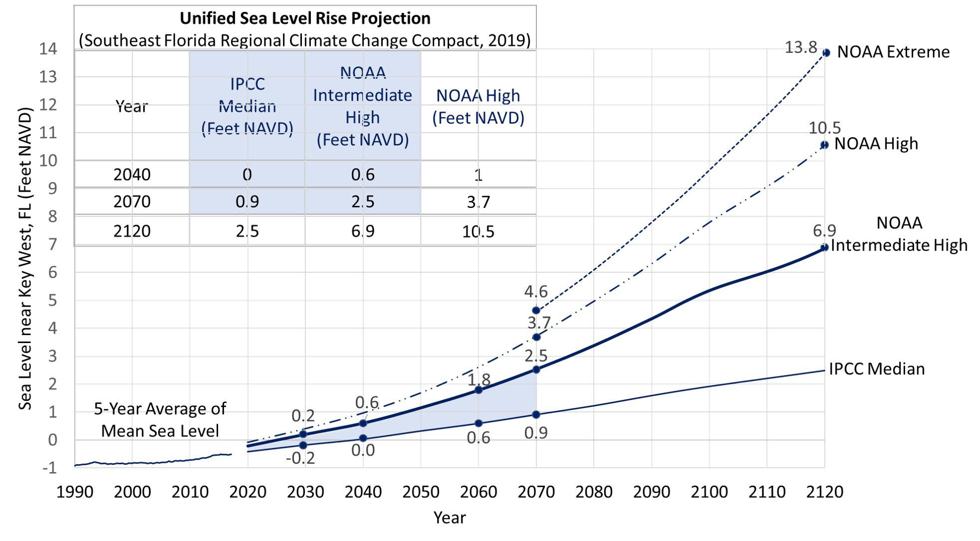
The 2019 Projection is based on projections of sea level rise developed by the Intergovernmental Panel on Climate Change (IPCC) Fifth Assessment Report (IPCC, 2014), as well as projections from the National Oceanic and Atmospheric Administration (NOAA) (Sweet et al., 2017), and accounts for regional effects, such as gravitational effects of ice melt, changes in ocean dynamics, vertical land movement, and thermal expansion from warming of the Florida Current that produce regional differences in Southeast Florida’s rate of sea level rise compared to global projections.
Advertisement
Based on past and current emissions, all projection curves assume a growing greenhouse gas emission concentration scenario, in which emissions continue to increase until the end of the century, consistent with the IPCC Fifth Assessment Report’s (AR5) Representative Concentration Pathways (RCP 8.5). Estimates of sea level rise are provided from a baseline year of 2000, and the planning horizon has been extended to 2120, in response to the release of climate scenarios extending beyond the year 2100 by federal agencies (NOAA and the U.S. Army Corps of Engineers) and the need for planning for infrastructure with design lives greater than 50 years.
In the short term, sea level rise is projected to be 10 to 17 inches by 2040 and 21 to 54 inches by 2070 (above the 2000 mean sea level in Key West, Florida). In the long term, sea level rise is projected to be 40 to 136 inches by 2120. Projected sea level rise, especially beyond 2070, has a significant range of variation as a result of uncertainty in future greenhouse gas emissions reduction efforts and resulting geophysical effects.
The 2019 Unified Sea Level Rise Projection includes three curves for application, in descending order, the NOAA High Curve, the NOAA Intermediate High Curve, and the curve corresponding to the median of the Intergovernmental Panel on Climate Change (IPCC) AR5 RCP 8.5 scenario. A fourth curve, the NOAA Extreme curve, is included for informational purposes, not for application, illustrating the possible upper limit of sea level rise in response to potential massive ice sheet collapse in the latter part of the century. This curve underscores that without imminent and substantial reductions in greenhouse gas emissions, much greater sea level rise is possible more than 100 years from now.
This guidance document describes the recommended application of the projection as it relates to both highand low-risk projects and short- and long-term planning efforts. The Work Group recommends that this guidance be updated, at a minimum every five years to reflect the ongoing advances in scientific knowledge related to global climate change and potential impacts.