2 minute read
The Earliest Newtown Map of 1816


History Spotlight by Doug Humes
Photos courtesy of the Newtown Square Historical Society
In 1816, the Pennsylvania legislature authorized mapmaker John Melish to make detailed county maps for Pennsylvania. What did he find notable enough to include on the Newtown map?
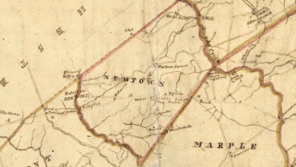
The West Chester Stage Road runs east and west, and was the route of the stagecoach from West Philadelphia to Newtown and then to West Chester. The route passed the Fox Chase Tavern right after entering from Marple. The Newtown straight road ran from the south to the north, bisecting the township east and west. An early school sat across the straight road from where Gentile’s is now located. The Hunter and Mendenhall (Teca!) farms lay to the south.

The 1816 Melish Map of early Newtown
Newtown Square Quaker Meeting is marked QM, at the same location it has been since 1711. At the next intersection, Goshen Road bisects the township running from Darby Creek to Crum Creek. Further north, a road runs east to a saw mill on Darby Creek – the road that today we call Saw Mill Road. The last road to the north takes you to Old St. David’s Church, on St. David’s Road. On the way, it crosses what was then a new bridge, built with funds left in an 1810 will by Thomas Walsh to replace the ford at that location with a solid stone structure. It remains in place today.
Goshen Road ran west to the Thomas grist mill. The covered bridge was still 44 years away. West Chester Road split at Boot Road, and the Frazer home, with the stage road crossing a bridge over Crum Creek into Edgmont and the President Tavern at the top of the hill, which we know today as La Locanda. At Crum Creek, a road we know today as Mill Hollow leads north to what once was a series of mills and distilleries, owned at the time by George Antricum (and misspelled on the map). Millers were paid in kind with part of the grain they milled, and with so much grain supply, a distillery was a natural addition.

Part of legend identifying the mapmaker
Newtown in 1816 was a simple farm community, largely populated by Quakers. In 1828, William Crosley would open up a cotton mill near Walsh’s bridge, and several other mills and factories would pop up along that section of the Darby Creek, turning Newtown into an industrial center for the next 60 years. Those mills and factories did not exist when John Melish made his map.
For more history on Newtown Square, Delaware County, and membership information, please visit our website at: www. NSHistory.org.


