
9 minute read
RIVER THAME PROJECT


River Thame – the value of an inland river WeBS project
Five years since its inception, an exciting project along the River Thame has already yielded rewards.
Nick Marriner Volunteer Trustee and WeBS coordinator
It may not be on too many people’s list of birding hotspots but an exciting new partnership between BTO and the River Thame Conservation Trust (RTCT) has put the River Thame firmly on the local birding map.
For those of you wondering where the River Thame is, its headwaters rise east of Aylesbury in Buckinghamshire where it flows south west into Oxfordshire past Thame before heading south to complete its c.40 mile journey towards the confluence with the Thames at Dorchester.
RTCT was established in 2012 with a mission to better understand and improve the biodiversity of the river but had little understanding of presence, distribution and/or the abundance of birds using the river and its floodplain.
With the fantastic support of BTO, a formal WeBS project was set up in 2015 with RTCT acting as local organiser overseeing 16 individual survey sectors, recruiting/training volunteers and managing the day to day running of the project.
Our first Core Count took place on Sunday 13 December 2015. Since then, the project has gone from strength to strength; 25 volunteers have been involved in surveying (10 of whom have not missed a month) and have recorded 53 wetland bird species across 897 visits and generated 5,807 records.
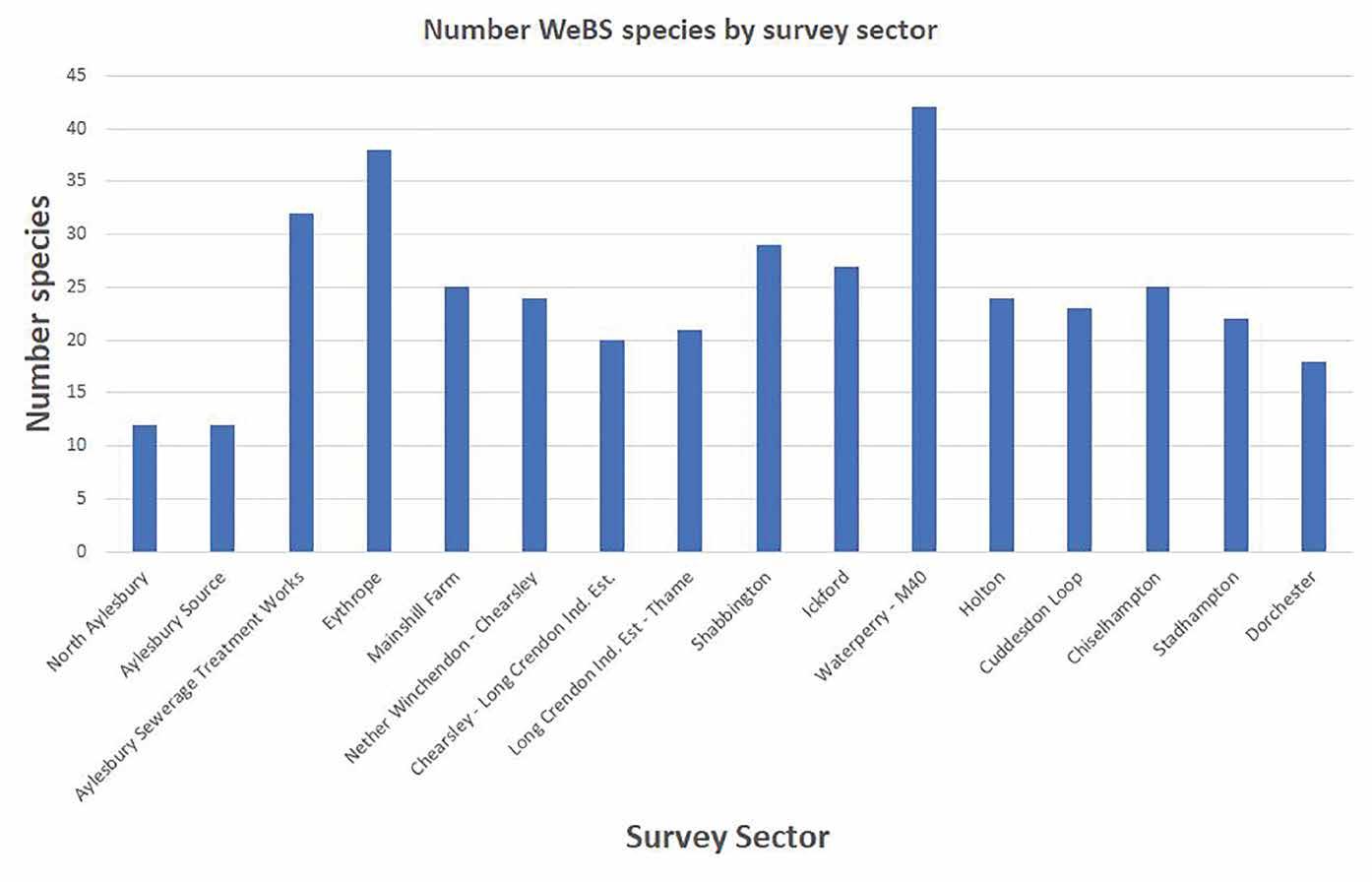
The records are now giving a clear picture of the wetland bird life of the river and its floodplain. As the graph opposite shows, the records have highlighted two key areas with greater abundance of wetland birds centred around the Aylesbury Sewage Treatment Works/Eythrope area and the Shabbington/Ickford/ Waterperry area.
The wet winter of 2020/21 established the Waterperry – M40 sector as one of the most exciting sites in Oxfordshire with counts of 1,400 Teal, 1,050 Wigeon, 105 Pintail, 83 Shoveler, 31 Gadwall, 189 Snipe and three Jack Snipe. Likewise, the Aylesbury STW sector established its profile in Buckinghamshire with records of Garganey, Wood Sandpiper and Jack Snipe.
The WeBS data has made a huge impact on the profile of the river and the work of RTCT with:
The new wetland at Waddesdon has already attracted both Ringed (left) and Little Ringed Plovers.
HABITAT CREATION PROJECTS RTCT has used WeBS data as a basis for two new major wetland habitat creation projects in partnership with the Freshwater Habitats Trust.
At Eythrope, a major new wetland complex has been created in partnership with the Waddesdon Estate comprising of a complex of offline wetland, river backwaters and new scrapes. Completed in 2020 the site is proving a real draw for passage waders with Greenshank, Common Sandpiper, Green Sandpiper,
River Thame - Waterperry to M40 10
River Thame - Holton 11
River Thame - Chiselhampton 13
River Thame - Dorchester 15 River Thame - Mainshill Farm 4 River Thame - Aylesbury Source 1
River Thame - Chearsley to Crendon Industrial Estate 6
River Thame - Shabbington 8
River Thame - Cuddesdon Loop 12 River Thame - Ickford 9 River Thame - Nether Winchendon to Chearsley 5
River Thame - Long Crendon Industrial Estate to Thame 7 River Thame - North Aylesbury
River Thame - Aylesbury Sewage Treatment Works 2
River Thame - Eythrope 3
River Thame - Stadhampton 14
Contains Ordnance Survey data © Crown Copyright and database right (2016)
The 16 sectors that make up the River Thame project site.
Dunlin, Ringed Plover, Little Ringed Plover, Oystercatcher, Jack Snipe and Grey Plover as well as an overwintering Great White Egret.
At Waterstock, a rotary ditcher has been used to create a complex of new wetland scrapes on the new Local Wildlife Site floodplain. Green Sandpiper was recorded on the first survey after completion!
FORMAL DESIGNATION OF SITES Surveys in the Ickford to Waterperry sectors have uncovered a real gem of an area of c.4 km of undisturbed river and rough grazing floodplain. Volunteers worked hard to engage landowners and secured their permission to apply for formal Local (County) Wildlife Site designation on two specific sites. Both were approved in 2019.
SPECIES PROTECTION The River Thame holds two populations of breeding Curlew and WeBS surveys have helped to keep track on their fortunes. Building on this the project has formed the basis of local coverage for this year’s BTO Breeding Waders of Wetland Meadows (BWWM) survey with existing volunteers providing data for BWWM sites along with their WeBS visits.
RTCT also now sits as catchment lead for the River Thame on the newly formed Upper Thames Wader Group working with other key catchments to set up practical projects in support of our breeding Curlew.
NEW RECORDS WeBS has also helped uncover exciting new records in what is a relatively unrecorded area. In addition to the wintering wildfowl, local rarities such as Gannet, Kittiwake, Osprey, Great Skua and Marsh Harrier have been recorded.
More excitingly, WeBS surveys have recorded the growing success of Goosander on the river, which are a rare wintering, and previously non-breeding, species locally. Growing numbers have overwintered with up to 13 birds recorded in 2020/21. A first breeding pair was found on the river in 2020 and a second pair with five fledged young was discovered in 2021 (a first ever record of breeding Goosander in Oxfordshire!).
The first five years of the project have helped establish a baseline from which we hope to build a growing dataset to track trends not only on the river but also of specific site based projects.
Previously the River Thame was known as a birding desert locally with very few, if any, sites watched on a regular basis. Since then, WeBS has firmly put the river on the birding map showing what can be done with a structured and focused surveying effort.
RTCT is rightly proud of, and grateful for, the work of its dedicated team of volunteers who have contributed thousands of hours of their time to support the project. Equally we are grateful to the BTO for its support in setting up and supporting the project – a real example of a volunteer-led partnership that is starting to make a big difference on the ground.
45
40
Number of WeBS Species
35
30
25
20
15
10
5
0 North AylesburyAylesbury Source Aylesbury Sewage Treatment Works EythropeMainshill Farm Nether Winchendon – ChearsleyChearsley – Long Crendon Ind. EstLong Crendon Ind. Est - ThameShabbington IckfordWaterperry – M40 HoltonCuddesdon LoopChiselhamptonStadhamptonDorchester
Survey Sector
The number of WeBS species recorded by survey sector.
Prioritising WeBS site coverage
Have you ever wondered why certain sites are identified as being a key site or higher priority in the WeBS Vacant Sites online maps? Several factors need to be considered in order to prioritise coverage of these sites.
Teresa Frost WeBS Manager
First things first: all WeBS counts are important and useful! Your counts are valuable in so many ways, and I’ll be returning to why later. We are grateful to each and every one of you for collecting such important data.
There are over 4,000 WeBS count sectors that are currently not being regularly counted. We have two main ways of recruiting people to fill the gaps. The first is our marvellous team, 140 strong, of volunteer Local Organisers, who can approach people directly and through local bird clubs and groups. The second is those who hear about WeBS through social media, articles or BTO training courses and who usually find their way to the vacant sites map on the WeBS website.
On the Vacant Sites map we show all WeBS sites. The ones that are already being counted are coloured grey, and the ones that need a counter are shown in shades of blue. The darkness of the blue relates to the priority of the site, with high priority sites in darker shades and a dark blue edge, and all the other vacant sites in a lighter blue with a light blue edge. If we have been told that there is an access issue for the site, it is still shown, but coloured orange.
If a potential counter looks at the map, they might only have a few sites near them that suit their interest – perhaps how far they are willing to travel, whether they have access to a car, and whether they would prefer a certain type of wetland. The Local Organiser can help them find a site that suits them in terms of their skills and experience in identification and counting. Priority status is just one more thing to consider after all of these factors – all else being equal, it is helpful for us for the higher priority sites to be chosen.


All priority WeBS sites prior to the review (left) and following the review (right) which increased the number of priority sites in inland areas. Higher priorities are in in darker blues.

Screenshot of the map at www.bto.org/webs-vacant-sites with example reasons of why some of the vacant sites are higher priority.
HOW IS THE PRIORITY LEVEL SET?
We have just completed a review of the priority status for all sites, based on current national reporting needs. We considered four aspects which were used to score each site individually and then combined into a total score that determined the priority. These were: 1. Sites that hold nationally and internationally important numbers of waterbirds, according to the most recent five year mean of peak counts; 2. Sites that strongly influence one or more national species indices and trends; 3. Sites in two environmental strata that are currently underrepresented in WeBS when estimating numbers of widespread waterbird species; 4. Sites that are nationally protected for waterbirds.
Some sites this scoring picked out might surprise you. For example some small inland waterbodies are very important for producing the Mandarin Duck index or are under-represented in our population estimate analyses. In the past most sites identified as higher priority were around the coast, but the new scoring has identified many sites in central Britain which are particularly helpful to get covered where possible.
WILL THE PRIORITIES CHANGE AGAIN?
It is likely that statuses will be reviewed again in the future, for example if we make any changes in the way WeBS counts are analysed, which would change some of the scoring decisions. As a counter this won’t affect you, any more than the recent changes have. Whichever site(s) you are counting, you are making a vital contribution, both on a national level to our understanding and conservation of waterbirds, but just as importantly on a local level, for management and protection of the site you count at, or local research.
Your WeBS Core Count priority dates for the 2021–2022 season...
2021...
10 October 7 November 19 December
2022...
23 January 20 February 20 March 17 April 15 May 19 June 17 July 14 August 11 September 9 October 13 November 11 December
Where tidal conditions at coastal sites are unfavourable on these dates, Local Organisers are encouraged to agree alternative dates. Ideally, these should be separated by at least three weeks from counts in the preceding and following months. Counts on different count units within complex sites should be coordinated to avoid the possibility of double counting.
Keep up-to-date with count dates and add them to your electronic calendar at: www. bto.org/webs/coredates

