7 minute read
1. Introduction & Overview

by BTVParks
1Introduction & Overview
Introduction Arms Forest is a very special place in the City of Burlington. It provides extremely important recreational opportunities and is home to very unique ecosystems and socio-historical resources-- all of which require careful planning and management. Its current recreational opportunities include hiking, dog walking, mountain biking, cross country running, and Nordic skiing,--among others. The forest also provides immense educational values, with the Burlington High School, the Rock Point School, the Crows Path program, and a myriad of other educational programs all utilizing the space. In addition, Arms Forest is home to rare natural communities, important geological features, and provides excellent habitat for a wide range of wildlife including large mammals, cavity-nesting birds, and forest amphibians like the spotted salamander. Amazingly, this is not all the small forest is home to—it also contains a wealth of historical and cultural resources from farming, to quarrying, and beyond. With all these diverse values at play, a clear and comprehensive roadmap for the redevelopment of the trail system in the forest was needed as the City and its partners work to enhance this important community asset. Creating this roadmap through a robust, community-driven trail design process is the overall intent of this plan and project.
Advertisement
Background The land known and managed as Arms Forest is collectively owned by the City of Burlington, the Burlington School District (Burlington High School), the North Avenue Alliance Church, and the Episcopal Church in Vermont (Rock Point). Since 2012, The City of Burlington, through the work of the Conservation division within the Burlington Parks and Recreation Department, has been working with the landowners and neighbors of Arms Forest to develop consensus on a shared management philosophy. The Lake Champlain Land Trust also holds legal interest in the lands through a conservation easement put in place to help protect the site’s natural and cultural resources into the future. The Elks Club of Burlington also owns lands the public has used as part of “Arms Forest” but they have not been part of the management agreement with the other landowning partners and their lands are not included as part of this plan. People have been walking, recreating, and spending time in the forest “behind the high school” for decades. The property has traditionally not been signed, and public access has been provided through trails leading off of the Greenway, behind the high school, behind North Avenue Alliance Church, and through the Rock Point/Episcopal Church lands. Management of the forest lands has not always been consistent across landowners and a number of trails have been built traversing the property over the years. Some of these have been “social” or user-created trails and others that have been built and/or improved upon by the City or its landowning partners. Some management information is found both on the site and online, but the level of information has not been commensurate with the forest’s unique history and ecological value. In 2018, the Rock Point and Arms Forest Coalition – which includes the Parks Foundation of Burlington, the Lake Champlain Land Trust, the Episcopal Church in Vermont, and the City of Burlington – recognized the need for collaborative management of the site to protect the its important natural resources and keep it open to the public. The coalition announced a goal of permanently protecting the critical shoreline forest and improving public access to the 163-acre forest block in the heart of Burlington. In addition, funds were contributed through the City’s Conservation Legacy Fund, supporters of the Coalition groups, the Vermont Housing and Conservation Board, the State of Vermont Recreational Trails Program, and private donors. An Arms Forest Ecological Mapping Report was generated by the Burlington Wildways Arms Forest Working Group in 2018, which inventoried the landscape features and priority habitats and natural communities in the forest. Following that report, an RFP was issued in early 2019 for an “Arms Forest Multi-Use Trail Scoping Study and Design,” of which this document is the result. Based on the findings of the ecological report, the goals of the RFP, and the initial conversations with staff from the City and its landowning partners, the overarching goal of creating an ecological improvement to the site was established for all future trail concepts. It was also recognized early on that a robust public engagement process was needed to gauge community preferences, share information, and vet ideas for the site.
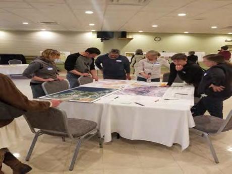
Public Process and Development of Alternatives Two public meetings were held in May of 2019. One of the public meetings was primarily organized for residents of the Killarney neighborhood while the second was open to the general public. Over 120 residents attended the meetings. An online survey asking many of the same questions as the public meeting was also distributed and received 232 responses. There was overwhelming agreement throughout both public meetings and the online survey that the naturalness and forest-based character of the site should be maintained. Trail improvements should tend towards lower key, low intensity trail development to maintain a natural, wild feeling. Walking, snowshoeing and cross-country skiing were supported nearly unanimously, while support for mountain biking and dog walking—both historical uses of the site—was much more split. Members of the community unanimously valued through connectivity on the site, continued use by the high school teams and programs, and increased protection and awareness of natural resources. Feedback from the public was then shared in stakeholder meetings with each of the landowning partners and decisions about what to explore in the trail concept alternatives were made by staff from the City and its landowning partners. Members of the City and project team also met with the Elks Club of Burlington prior to concept development to discuss potential partnership opportunities and/or coordinated management, but the Elks Club representatives declined to participate in the planning process, including coordinating public access through their lands. Exploring the scale of trail redevelopment (how much trail should be reclaimed vs re-routed/improved) was an overarching goal in developing trail concept alternatives. Various schemes were discussed and agreed upon to explore, focusing on access points and trail location and character (materials, width, etc.). This allowed the consultants, the City, and the landowning partners to focus on the needs and function of the forest and the trail system first, before turning to the allowed uses. Throughout the project, support for bicycle use was split. In terms of mountain biking it was decided that at least one trail concept alternative would exclude bicycle use from the concepts to be shared with the community at the next public meeting. This held true on the part of the public and of the staff of the City and its landowning partners, so exploring this through the trail concept alternatives was critical. In October 2019, three trail concept alternatives were shared with the community at a final public meeting and an online survey. Approximately 20-25 residents came to this second meeting and 65 survey responses were received. The concept that retained the most miles of trails and mountain biking use was indicated as preferred by the most people. However, the combined tally for the two other concepts, both of which showed a pared down and minimal trail network, was slightly larger. As a result, the consultant team and City staff chose to pursue a final concept that strikes a balance between the three concepts. Preferred Trail Concept The preferred trail concept creates an ecological improvement to the site, ensures sustainable public access, maintains connectivity to the Greenway and North Avenue, and serves the needs of the high school cross-country team, educational programming, and other community users of the forest. Trails that are not well-designed, constructed or located are rerouted and trails that unduly impact natural resources are closed and slated for reclamation. Low impact, low key signage is recommended to provide management information and interpretation, so rules and protections are adequately understood and followed. The design of the trails, signage and other improvements are intended to direct use in appropriate areas of the forest and prevent users from going off trail and creating new unsanctioned trails and pathways. Given the feedback heard throughout the project, the scale of bicycle use is limited to the main pathways through the forest (Universal Access and Natural Surface Interpretive Trails) at this time. The biking experience provided on these trails will be very different than what has been provided in the forest historically. For this reason, it was acknowledged that education on why the policy decision was made will be important for compliance, as will working with the affected groups to determine other locations within the City to provide a much-sought bicyclng experience within Burlington. It was also acknowledged that there may be the potential to open up some of the proposed hiking-only trails to be multi-use trails in the future if initial trail reroutes, closures, and efforts to ensure compliance with policies are successful.