
8 minute read
Turkey, Syria quakes: Shallow depth of shocks key in devastation


Phivolcs to boost R&D to address risk reduction through nuclear science

TWO science agencies forged a pact in order to strengthen research collaboration on the applications of nuclear science and technology in the fields of volcanology and seismology.
The Department of Science and Technology agencies, Philippine Nuclear Research Institute (DOSTPNRI) and the Philippine Institute of Volcanology and Seismology (DOST-Phivolcs), recently signed a memorandum of understanding (MoU) for the purpose.
Held at the DOST-Phivolcs Auditorium in Quezon City on January 25, the signing signaled the joint initiatives of the two DOST agencies to harmonize their efforts to address disaster-risk reduction and management.
The initiative was aligned with the current administration’s thrust to pursue the OneDOST4U advocacy to better improve delivery of public service.
Under the MoU, the DOST-PNRI and DOST-Phivolcs will focus and venture together on projects related to the fields of geochemistry, isotopic techniques, volcanism, active faults, geothermal and volcano-hydrothermal.
Both institutions agreed to share its respective pool of experts, resources, equipment, facilities, and other information relevant to the project.
“Through this MoU, we will be able to freely use each other’s resources to continue to answer scientific questions that both DOST-Phivolcs and DOST-PNRI are facing,” said DOST-Phivolcs Director Teresito C. Bacolcol.
“We hope to gain knowledge, data and information from the works that will be implemented within the scope of the MoU. Likewise, DOST-PNRI researchers are encouraged to build the capacity of DOST-Phivolcs researchers through shared research activities such as sample preparation, analytical works, and training,” Bacolcol said.
He added that it is a good opportunity for the returning PhD and MSc graduates of DOST-Phivolcs to continue their research using the same analytical equipment they’ve used during their stay in the universities.
At the same time, DOST-PNRI will also benefit from the volcanologists and seismologists through the sharing of ideas they have on certain projects that DOST-PNRI researchers are working on.
Meanwhile, after the program and signing, scientists and experts from the DOST-PNRI visited the Geochemical Laboratory located at the DOST-Phivolcs office in Quezon City.
Allan Mauro V. Marfal/S&T News Services
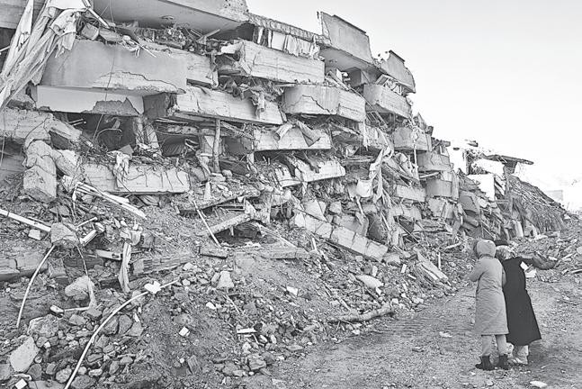
At the time of writing, the death toll has risen beyond 11,000 people and will continue to rise over the coming days and weeks. (As of February 9, the Associated Press reported more than 17,000 died.— Editor) Hundreds of thousands more have lost their homes.
There are many reasons why the death and devastation have been so terrible.
First and foremost, the sheer magnitude of the two main events and their associated aftershocks. These earthquakes, which measured 7.8 and 7.5 on the moment magnitude scale, each released roughly as much energy as the largest-ever atomic bomb test carried out during the Cold War— around 50 megatons, in 1961 by the former Soviet Union. And there were two of these events in the same region, separated by a matter of hours.
To this we have to add the clusters of aftershocks which follow on from the main events. These are smaller (mostly lower than magnitude 5) but will continue for several days, gradually decreasing in intensity and regularity.
They are nevertheless dangerous, as buildings already seriously weakened by earlier events may be caused to collapse. This inevitably further hampers rescue attempts in the region.
Another factor is the timing of the first and largest earthquake. It occurred at 4.17am local time, when most people would have been asleep in their homes.
During an earthquake, the great majority of casualties are caused not by the shaking, but by the resulting collapse of buildings. The timing of this event was about as bad as it possibly could be—many people had very little opportunity to escape from their homes in time. This is likely a major factor in the very high number of deaths and injuries.
Depth charge
BUT a key geological contribution to the devastation was the relatively shallow depth of the earthquake hypocenters: 18 kilometers (km) for the first 7.8 magnitude event and 10 km for the later 7.5 shock.
The hypocenter is the point at which the fault begins to rupture at depth.
In global terms, these are relatively near-surface shocks. There are two reasons why this leads to a greater degree of destruction.
Put simply, the first reason is that the shallower an earthquake is, the closer the Earth’s surface is to the hypocenter.
This means that the ground shaking is more intense and destructive. There is less opportunity for the shockwaves to dissipate, as happens when earthquakes occur deeper in the Earth and they travel through tens of kilometres of rock.
The second reason is that the faults that generate earthquakes larger than 5.5 are more likely to rupture through to the surface. This creates—almost instantaneously—a ground displacement whereby one part of the ground literally moves by several meters relative to an adjacent part.
These surface breaks —also known as “capable faults”—are incredibly damaging. They can lead to the severing of major subsurface and surface infrastructure—including water mains, electricity cables, gas pipelines and tunnels.
There are already reports of damage to pipelines in Turkey following the February 6 events. Spectacular satellite images and ground-based photographs are also emerging of offset roads and railway lines, as well as serious damage to buildings that straddle the ruptures.
All of this occurs in addition
FILIPINOS won six of the seven prizes in the latest edition of the annual photo contest of the Southeast Asian Regional Center for Graduate Study and Research in Agriculture (Searca).

Themed “Emerging Agricultural Innovations for the Next Generation,” the 2022 edition of the competition searched for images that depict technologies and innovation that are modernizing and transforming agriculture and rural development towards increased food supply and security, Searca said in a naews releasse. Now on its 16th year, the Searca annual photo contest attracted 760 entries from 182 photographers from 10 countries, namely, Brunei Darussalam, Cambodia, Indonesia, Lao PDR, Malaysia, Myanmar, the Philippines, Singapore, Thailand and Vietnam.
The top three prizes went to photos showing innovation in planting crops, while images showing various technologies used in agricultural activities were selected for the special awards.
The first prize winner is a photo by Lea Caguiat showing children happily watching a rice seedling transplanter at work in a rice field.
Dennis Ivan Baliguat bagged the second prize for his photo of a Fresco-Greenovation project that integrates hydroponics, Internet of Things, automation, computer vision, and machine learning technologies for precision farming.
Fresco-Greenovation is a social enterprise founded by young farmers with degrees in agricultural science and engineering know-how. to the damage caused by shaking, liquefaction of soft sediment in valleys, and landslides.
The third prize went to Fredelon Sison’s entry that pictures a man building a locally designed aquaponics system in his small shop well after the sun had gone down.
The Searca Director’s Choice Award was bestowed on Jaime Singlador’s photo of an agricultural technician introducing to a young student a hydroponic system that uses a solar power-controlled water sprinkler inside plant boxes that are suitable for small spaces and backyard farming.
Jomar Mariñas won the Department of Education Secretary’s Choice Award for his picture of a combine harvester juxtaposed with a carabao in the foreground.
Robert Dela Vega was selected as Best Youth Photographer for his photo of a young boy looking up from a laptop and reading a material while seated near an elderly person grasping some rice grains in a flat basket. His picture also won the People’s Choice Award via online voting.
Pham Quoc Hung’s photo of rice seedlings in rolled-up mat nurseries ready for transplanting won the Best Agricultural Innovation/ Technology Award. Mat nurseries use less land, can be installed closer to the farmer’s house than traditional field nurseries, and use less labor for both transporting seedling mats and replanting.
The winning images received cash prizes and will be displayed within the Searca building, shared on its social media and website, and featured in various Searca publications.
In a recent blog, Professor Hasan Sözbilir of the Dokuz Eylül University Earthquake Application and Research Centre has studied the region and reported: “As far as I can see, at least three fault segments have been broken. The total length of the surface fracture has exceeded 500km.”
So why were these events relatively shallow in this region?
Some of the largest earthquakes known to have occurred are associated with the so-called “Pacific Ring of Fire”. These earthquakes are commonly generated as deep as 700km, as the strong, dense oceanic plates plunge down into the Earth below the surrounding continents.
Turkey, however, lies in a region of weaker, mainly continental lithosphere where the crust is only about 30 km thick, close to a point where three tectonic plates come together—Africa, Arabia and Anatolia.
The convergence of the Arabian plate is squeezing the wedgelike Anatolian plate out to the west, generating a series of subvertical, strike-slip faults, such as the East Anatolian Fault, which failed during the magnitude 7.8 event.
In such continental crust, the strongest part—and the most likely point for large earthquakes to be born—lies typically at between 10km and 20km depth.
In settings of this kind, shallow, surface-rupturing faults are more likely to form.
Wrong time, wrong place
A THIRD factor is simply that the region where the earthquakes occurred is highly populated. Given the timing, a substantial loss of life is almost inevitable following an event—or events—of this magnitude.
Deadly earthquakes are well known in Turkey. In the past 50 years, there have been at least four major events with substantial loss of life—in 1975, 1983, 1999 and 2020.
Following the Izmit earthquake in 1999, there were serious efforts by the Turkish authorities to improve building standards to better resist earthquakes.
But there are limits as to what you can do in a highly populated area with events of this size. And we have to remember that the two main seismic shocks were perhaps more than twice as big as the largest known historical earthquake in this region.
Furthermore, in Syria we have to add the fact that years of ongoing civil conflict have substantially degraded the building infrastructure, making the region event less resilient to the effects of seismic shaking. This will likely also hamper efforts to deliver assistance and aid—and, in the longer term, to rebuild. Bob Holdsworth, professor of Structural Geology, Durham University/The Conversation (CC)
DOST-FPRDI names substitute trees for wood carving
GOOD news for the country’s wood carving industry, which has been experiencing shortages in its raw material supply! Two wood species—yemane and paraiso—were identified as ideal materials for wood carving.
The two wood species were identified through a recent study made by the Department of Science and Technology’s Forest Products Research and Development Institute (DOST-FPRDI).
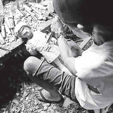
For centuries now, sculptors in the town of Paete in Laguna province, have produced remarkable art works and until recently, have successfully passed on their skills to younger generations.

All these years, many of the craftsmen have relied heavily on batikuling (Litsea leytensis Merr.), their favorite raw material.
Batikuling wood is known for its right mix of hardness and softness, and how it easily resists insect and fungal attack.
Due to overuse, however, the tree’s supply has shrunk dramatically in recent decades, putting it on the government’s threatenedspecies list.
“To help address the problem, we studied other trees which could serve as substitute material,” said DOST-FPRDI’s Armando V. Gillado Jr.
“We found that yemane (Gmelina arborea Roxb. ex Sm.) and paraiso (Melia azedarach L.) are ideal alternatives since their wood properties are similar to those of batikuling,” Gillado said.
After looking into the wood’s physical and strength properties and acceptability to members of the Paete Artists Guild, Gillado and team found that yemane is easy to carve and finish.
It is also insect and fungi-resistant, and has the right hardness. It even scores higher than batikuling in texture and color.
At the same time, besides the required wood qualities, paraiso has good grain direction and smell, and is easy to dry.
Yemane is a fast-growing tree widely planted in industrial plantations all over the country.
Paraiso, meanwhile, is a lesserknown tree commonly grown in private plantations in Quezon province.
“It is important to support the country’s wood carvers,” Gillado said, “because we foresee much growth in their sector. In a world drowning in mass-produced consumer goods, there is a special place for products of the so-called creative industries, for things painstakingly made by hand using individual talent and skill.”
The study was conducted as part of DOST-FPRDI’s “Gubat Obra: Forest-Based Creative Products S&T Program.” Rizalina K. Araral and Julius T. Pelegrina/S&T News Services


