by Judy Aslett and Steve Holloway
Ed Lowrie


by Judy Aslett and Steve Holloway
Ed Lowrie
Publisher | Dan Merton dan@caribbeancompass.com
Advertising & Administration Shellese Craigg shellese@caribbeancompass.com
Publisher Emeritus | Tom Hopman
Editor Emeritus | Sally Erdle

Editor | Elaine Lembo elaine@caribbeancompass.com
Executive Editor | Tad Richards tad@caribbeancompass.com
Art, Design & Production Berry Creative abby@berrycreativellc.com

Parts left out of “Shelter from the Storm” Ahoy Compass readers!
“Shelter from the Storm” (August 2024 Compass) was as generic as possible. My method of tying into mangroves applies to monohulls, catamarans and power boats of all sizes and to any island where refuge in mangroves is available and permitted. Or places with boatyards.
The article does not address stripping windage. Roller furling genoas are top of the list. Bow into the mangroves limits their exposure to the wind, which might not be enough. Your call, Captain. If you leave it up, secure it well and back up the control line that keeps it furled. I’ve seen a genoa come open in a blow — seriously dramatic stuff.
I say little about anchoring out in the bay for a storm threat other than that I’ve done it. Don Street told us long ago that there are almost no places nowadays where one has enough room to set up properly — traditionally a spider web of at least three anchors (seven in Don’s case) on fifteen to one scope in a circle around the boat. Nor would I attempt the myriad details of how to tend such an array during a serious blow, changing wind direction and maybe other vessels blowing down on you, not to mention the fun of recovering all that ground tackle afterwards. There is an alternative, two anchors in tandem on the same rode. It sounds interesting but is beyond my experience.
And I say nothing about securing to a dock, which many do with high strength, low stretch rope that will rip cleats from the deck, instead of high stretch, three-strand nylon. Weathering a storm dockside is generally a bad idea and many docks won’t let you do it.
Here’s a novelty I come across now and then. A yacht needing a piece of rope for anything from lengthening the towline on a dinghy in a following sea to tying in for a storm. “We don’t have a single piece of extra rope aboard.” Now, aboard Ambia, rope was treasure. Spare sheets and halyards, lots of small stuff for control lines and whatever and extra anchor rodes for either storm anchoring or tying in. Rope stows well and synthetic rope lasts forever (for our purposes) and holds its value — and rope is great for barter in the anchorage in case times get tough. On a sailboat, rope is better than money in the bank — it is at hand when you need it.
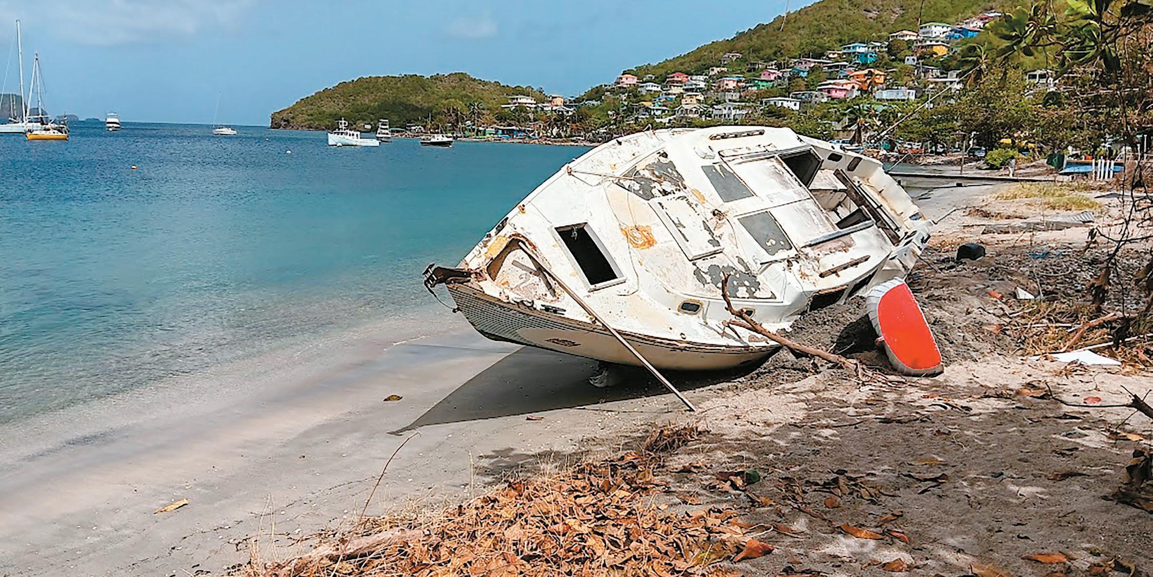
“Shelter from the Storm” mentions Hurricane Ivan in 2004, which wiped out almost all of the fleet in the south of Grenada and did unbelievable damage ashore.
It was a large storm and until hurricane season of 2017 it set records, including farthest south for a Category 5, but it wasn’t the worst storm of its time and Beryl is proof that there will be many worse storms in the future — increasingly so. Warming sea water fuels them.
A lot of us plotted Ivan all the way across, using latitude/longitudes reported to a tenth of a degree. Sometimes the forecasters corrected the supposed center by a fraction of a degree. Comparing one report to the next sometimes gave the illusion of a change in course or speed. After the storm, some said, “Ivan was all over the place!” My plot of Ivan is amost a straight line across the
North Atlantic to the south of Grenada. But, as my story says, you don’t know what the storm will do. So, find shelter.
Fair Winds, Hutch OneManSpeaks.com
The Myth of the Mangroves
Dear Compass,
The truth is, and this is the bottom line, people believed that putting their boat in the mangroves would keep them safe. Even though they knew, with 24 hours notice, that Carriacou would be in the eye of the Category 4 hurricane called Beryl, which ultimately became a Category 5.
Some liveaboards and local fishermen in Carriacou just didn’t want to move. Carriacou is home. If they had tried to leave, some of the boats may not have made it south as far as Trinidad which was probably the only absolutely safe place to be. They may have made it as far as Grenada, and most boats in anchorages and marinas there survived unscathed. Other boat owners simply made the wrong choice and they should and could have fled days before, when Beryl was already threatening to come dangerously close.
So why did so many people, about 200, believe that leaving their boats in the mangroves would be safe?
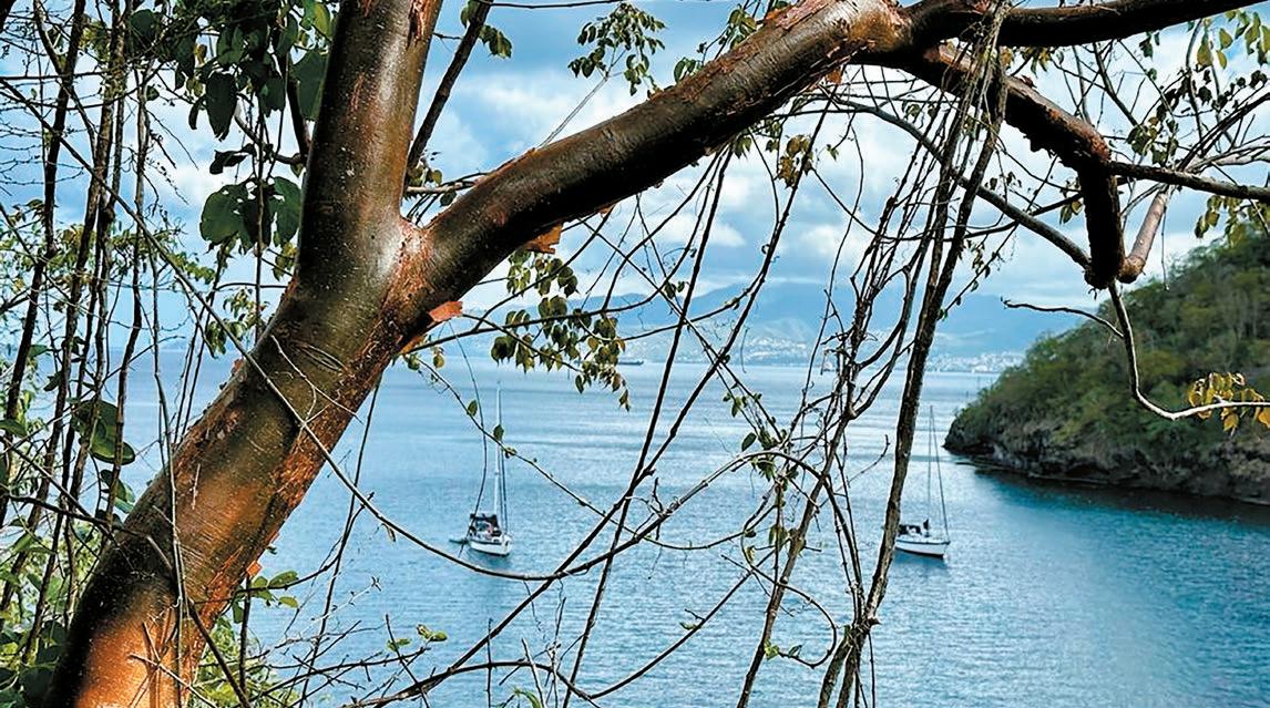
For centuries, long before boatyards and marinas, fishermen and small boat owners have been using mangroves for protection. And usually it works. It’s best to be tied in with as many lines as possible. Most go stern-to with all the anchors as they have holding them off. It may be better to be side-on but people are wary of getting their boat scratched. Needless to say, plenty of space between boats is essential, and there is no guarantee the lines will hold if the storm reaches the strength of a Category 3 or 4 hurricane. Other than that, you should be fine.
In more modern times some take their chances ashore. In Carriacou they were strapping the boats down to concrete blocks buried in the ground with hurricane ties.
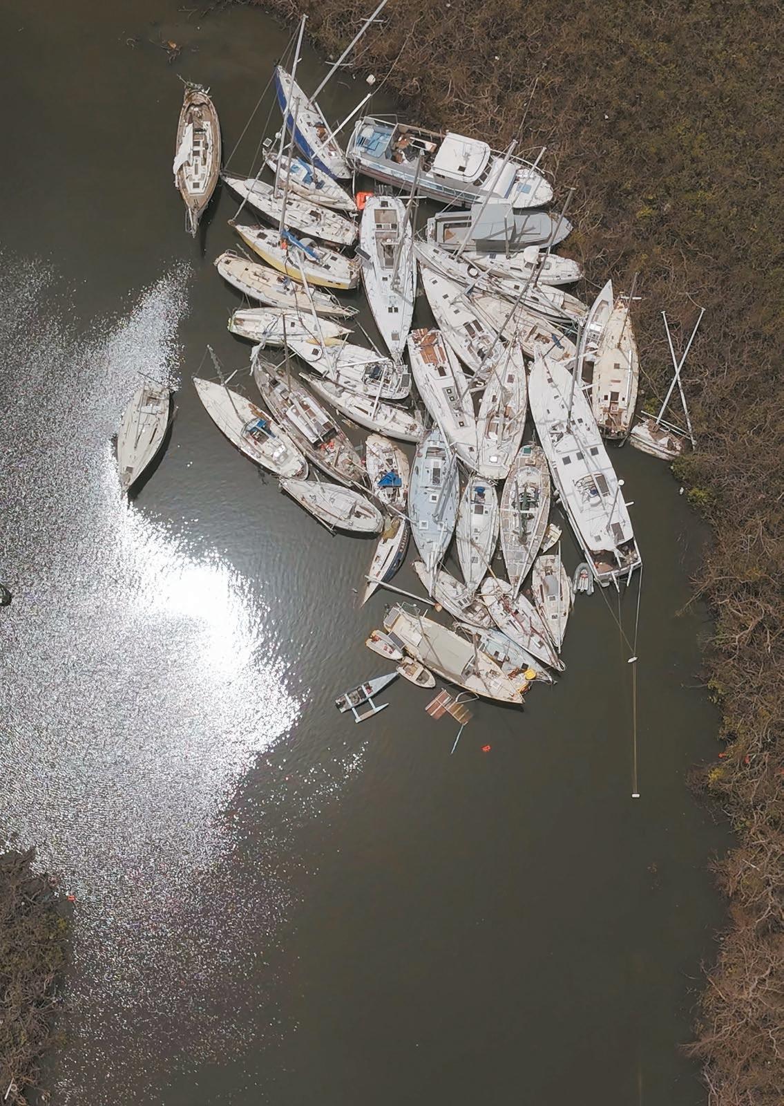
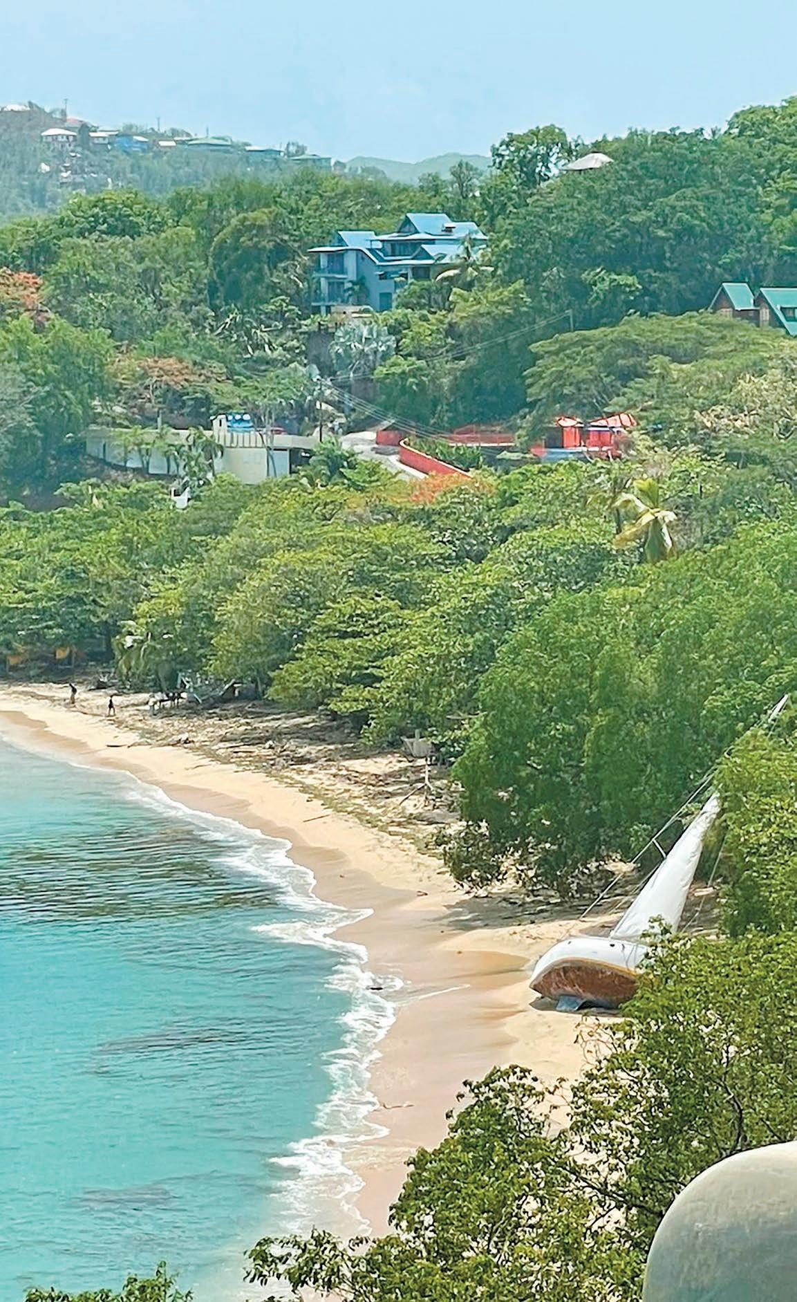
But in the event on July 1, 2024, hundreds of boats in the Carriacou boatyards were knocked down, one boat hitting the next, collapsing them like dominoes. In the mangroves things were even worse.
—Continued on next page
—Continued from previous page
About 50 people were on their boats when the hurricane hit. It is amazing no one was killed. If you had been on one of the catamarans that was picked up by the hurricane and flipped into the air to land either in the water or on top of the mangroves, you probably would not have survived.
So on July 2, once Beryl had passed through, around 20 boats were sunk and another 80 or so stuck in the mangroves. Those which had managed to make their way out were damaged to various degrees.
But help is on its way, right? Wrong. While the world, and more immediately those close to Carriacou and the surrounding islands, are gathering emergency aid for those on land who’ve been devastated by the hurricane, there is no thought, no aid and no network of support for those caught in the mangroves. They have slipped though the net.
No one would pass by a ship in trouble at sea without offering help. And yet that is exactly what happened to those in trouble in the mangroves.
Weeks after the storm, boat owners and local fishermen have done their best to re-float boats with whatever they can get their hands on, barrels for flotation, ropes and buckets. Now Operation Cruisers Aid has stepped in to buy and supply crash pumps, flotation bags and epoxy. They’re also directing volunteers to add valuable support to the rescue effort.
So why did it take so long to get help? Again, a simple truth. We as a sailing community were not prepared. We, like the rest of the world, were thinking about those on land. They needed food, water, fuel and the first to reach the scene of the disaster carried these supplies and provided much needed aid.
In doing so they sailed right past the boats in the mangroves.
Today, Operation Cruisers Aid is providing support and boats are being recovered. But how many more could have been saved if help had come sooner? The extreme winds had blown most of the boats to one end of the mangroves and then, after the eye went through, to the opposite end. Boats at times were heeling to the extent they would be at a knockdown at sea. Masts were flying and winches and broken deck fittings were piercing neighboring boats as the vessels heeled and rolled, one against the other. Most of these boats were taking on water so time was critical. Once the water hit the electronics and the bilge pumps didn’t work, the boats filled with the extremely caustic mangrove water dissolving wires and anything metal.
And then there’s the looting. This started within hours of the hurricane going through. High value and useful items at first, solar panels, batteries, then winches and other boat items that could be sold. Then boat contents, personal items taken by opportunistic thieves and organized gangs, sometimes when boat owners had simply left temporarily in search of water and food.
If hurricane Beryl does nothing else, it has provided a moment for us, as cruisers, to think ahead. Of course we can provide valuable emergency aid for those on land as the result of a hurricane. But we can also help other cruisers. No one else will, and arguably with the devastation on land, no one else should. Most of us are here by choice. And a growing number live on our boats. There are enough of us now to form a community that can provide and receive help from each other. Three weeks was too long for boats caught in the mangroves to wait for help. And never again should anyone believe, that in the face of a hurricane, the mangroves are safe.
Judy Aslett and Steve Holloway
S/V Fair Isle
Find Operation Cruisers Aid at https://operationcruisersaid.miraheze.org/wiki/Main_Page
We received this second letter from Hutch after the hurricane hit Carriacou. Our hearts go out to this longtime contributor and valued friend of Compass in his time of loss.
—Continued on next page

—Continued
July 7, 2024
Dear Compass,
Here is a taste of the story, but only a small fraction.
Summary: Most of Carriacou was utterly destroyed, including my home.
My August 2024 story in Caribbean Compass, “Shelter from the Storm,” speaks of four storms that actually caught us, only one of which was hurricane force, 60 knots. Thus, the story says, I’m no expert … or maybe getting hit so seldom makes me an expert.
I watched Beryl come across the Atlantic, way early for a Cape Verde storm. Her computer graphics showed electric blues and greens swirling into bright yellows and reds surrounding her eye. She was beautiful. But she was tracking straight for the Grenadines — where I am.
I sold Ambia and moved ashore. Aboard Ambia I would have had all the work of setting up for a serious storm that I tell of in “Shelter.” Ashore, all I have to do is clear the veranda and close the shutters and louvers … well, and provision for a couple weeks or months to survive the aftermath. One should be ready to be self-sufficient for a while after a serious hit.
The forecast was ominous. She was at 110 knots, expected to strengthen to 125 as she crossed the islands. And it appeared it would be a direct hit.
Question: Should I weather the storm in my second-story apartment or move into the more substantial house atop which my apartment sits? In my home, the only serious shelter is in the bathroom, a small block room with a concrete roof — which I deemed sufficient should it get that bad.
The storm hit us during daylight on Monday, July 1, 2024, roughly twenty years after Ivan.
Ashore and in a house, I had less sense of the wind velocity and direction. The wind was strong and building, but I was still feeling comfortable. Then the roof exploded, in an instant. I knew I had seconds, grabbed the computer and got in the bathroom. I spent several hours standing in the deepest corner of the room with occasional glances out the door as Beryl raged stronger and stronger. The walls shook ever harder until they finally fell. The eye of the storm arrived and I stepped out to have a look. Then, as the trailing wall of the eye arrived, I ducked back into my shelter for the second half. The second half was more noisy and violent than the first half.
When it was over, my entire apartment had been brought down, everything except the bathroom and the kitchen counter. Most of the wreckage of the house lay in a pile on the flooded floor with all of my stuff buried under it.
Then the storm was over, now the work begins.
July 14, 2024
I should have sent this when I finished the above. I’d intended to finish and send the next day. Then complications started setting in, including the government offering free internet … which clogged the system. More to the point, however, is an insightful comment Nephew Zach made: “And for everyone who survived, the real work is probably just beginning. Find essential goods, recover infrastructures, begin a complex process of rebuilding ….”
I hired a helper, Edwin, a friend and good worker. He dismantled the fallen walls, saving the bolts and screws, and stacked them in a pile at the edge of
what is now a large deck with the bathroom and kitchen counter still standing. Then a trapline tent was rigged and I moved back in the day before yesterday. I am now living a kind of camping lifestyle that has much of the simplicity of life aboard my little yacht. It is sufficient (and pleasant) in our normal weather. We’ll see how it stands up to our next weather threat.
I have it better than many or most of my fellow islanders. And I have had a lot of help from friends. I am going to rebuild with camping and the next tropical storm in mind.
One Love, Hutch
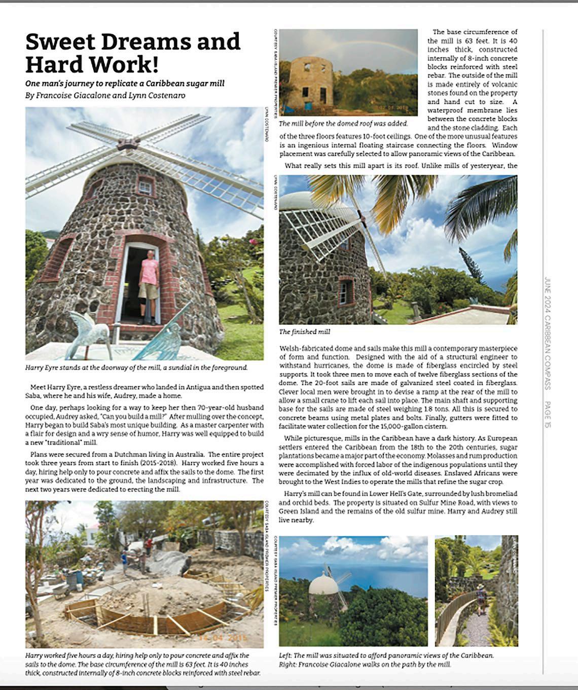
Building Windmills
Dear Compass,
We were delighted with the article you published about our mill (“Sweet Dreams and Hard Work!” June 2024; caribbeancompass.com/sweet-dreams-and-hardwork). It was interesting to build. We received help from Pleun Hitzert, who has built an amazing full height windmill in Western Australia called The Lily Windmill (https://www.thelily.com.au). Ours by comparison is sugar-mill size! He sent us plans and dimensions and was always there for advice.
Harry & Audrey Eyre


The JN Group, through JN Money Services Limited and JN Cayman, has established the I Support Jamaica Fund to facilitate donations to help Jamaicans most affected by Hurricane Beryl.
Residents of Resource District in Manchester, Jamaica, work to rebuild a house destroyed by Hurricane Beryl.
Horace Hines, general manager for JN Money Services Limited, is encouraging Jamaicans, Caymanians and others in the diaspora and around the globe to support the initiative, noting that it will help significantly with rebuilding lives and restoring hope in affected communities.
Preliminary estimates indicate that the early season hurricane caused extensive damage across several sectors, including some $10.25 billion in damage to the main road network and an estimated financial loss of $4.73 billion to the agricultural sector. The Ministry of Education and Youth also reported that Hurricane Beryl caused $797 million in damage to schools in six of the seven educational regions.
For more information on the I Support Jamaica Fund, visit www. jncayman.com.ky/beryl-recovery
2025 marks the 40th edition of the Atlantic Rally for Cruisers (ARC), which has crossed the Atlantic from Las Palmas de Gran Canaria to the Caribbean every year since 1986. When the 2025 rally concludes in St. Lucia, over 8,000 boats and 40,000 sailors will have sailed the Atlantic
with the support of the ARC over the last 40 years. To celebrate this 40-year achievement, there are discounts for all entries less than 40 feet and for any boats or skippers who participated in the inaugural rally in 1986.
In addition, £40 from every entry fee will be donated to the newly formed World Cruising Positive Impact Fund. Cruisers preparing to start from Las Palmas will be invited to add hands-on contributions by planting trees in the mountains above Las Palmas, working with Fundacion Foresta. So far, 3,770 trees have been planted in the “ARC Forest,” helping to capture carbon and improve rainfall retention.
“Forty years is a landmark anniversary,” says Paul Tetlow, World Cruising Club managing director. “Supporting local organizations on our route has always been a part of the rally, from the ARC Forest in Gran Canaria to supporting local sailing in St. Lucia, and our new Positive Impact Fund will enable us to reach more charities and communities in the countries we visit."
Visit www.worldcruising.com or mail@worldcruising.com
Marva Williams, formerly festivals and events manager at the Discover Dominica Authority, was appointed the organization’s chief executive officer in August 2024.
In her new role, Williams will be instrumental in setting the strategic direction of the Discover Dominica Authority, enhancing Dominica's global tourism presence, and promoting sustainable growth in the sector.
Williams is also a lecturer in digital brand management at the University of the West Indies Global Campus.

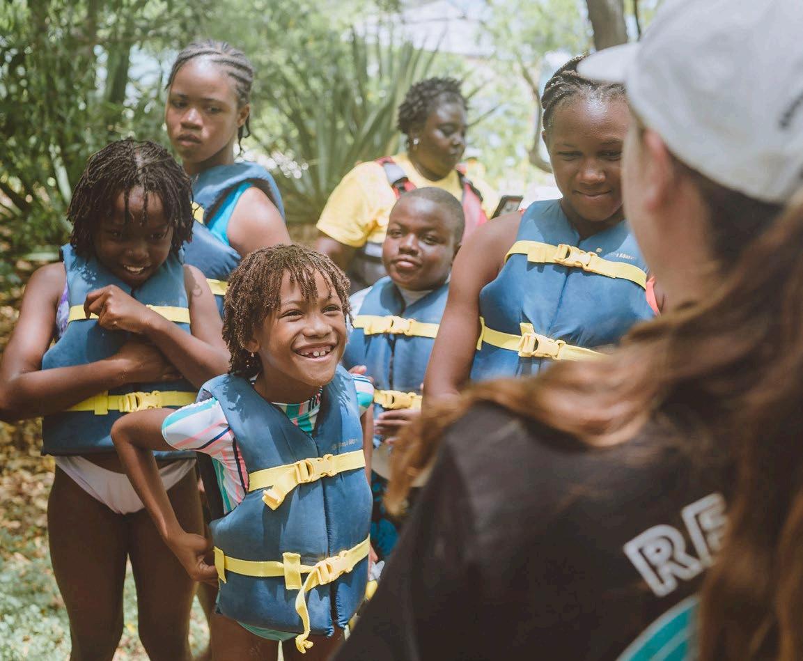
For many local communities in the Caribbean, the ocean is the foundation of livelihoods such as fishing and tourism. On the other hand, generations have passed down a fear of open water. Elkhorn Marine Conservancy (EMC) is providing ocean-based educational opportunities for youth and adults in Antigua, aiming to change the preconceived mindset that marine environments are to be feared.
EMC has collaborated with local summer camps, offering excursions for campers to learn about coral reefs and experience one of EMC's coral nurseries, learning about coral ecosystems, observing the process of coral reef restoration, and coming to appreciate their beauty and significance. In total, EMC has brought out 88 children from five summer camps, providing them with an opportunity to observe these ecosystems up close.
—Continued on next page
—Continued from previous page
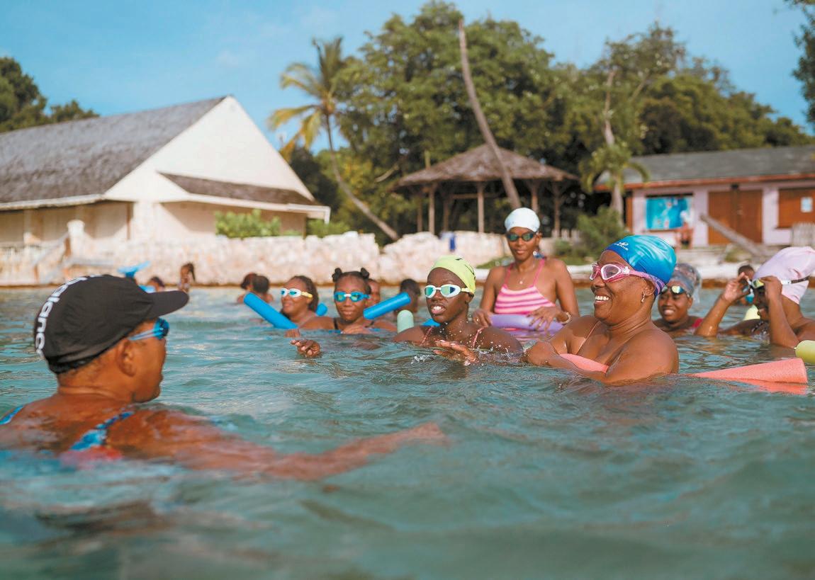
Recognizing that many local Antiguans lack swimming skills, EMC has introduced adult swim lessons at a subsidized cost, collaborating with “Splashing with Clashing,” a mother-daughter team with over 20 years of teaching experience, to teach essential swimming skills and address the participants’ fear of the ocean. The program culminates in a snorkel excursion to one of EMC’s coral nurseries.
EMC has also expanded its ocean-based programs into the classroom with the launch of "Into the Wild with the EAG: The Coral Code."
Developed in partnership with the Environmental Awareness Group (EAG) and supported by the Ministry of Education, this initiative provides all of Antigua's 22 secondary schools with comprehensive educational materials. The program aims to educate students about coral reef ecology, their importance, and the urgent need for their protection, with the goal of inspiring a new generation of environmental stewards.
For details log on to the group’s website www.emcantigua.com

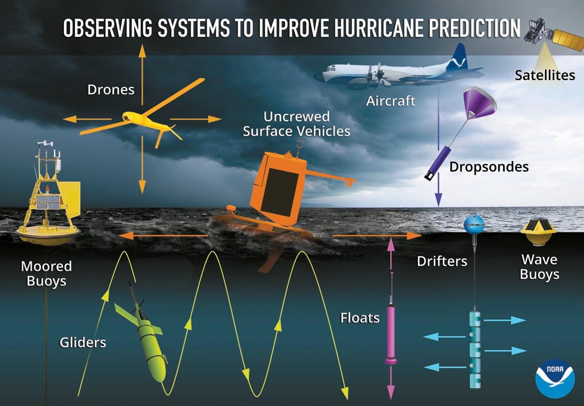
Although Hurricane Beryl’s ferocity was unprecedented — the Atlantic’s earliest forming Category 5 tropical cyclone on record, developing and intensifying to maximum wind speed in less than four days — hurricane scientists with NOAA’s Atlantic Oceanographic and Meteorological Laboratory were prepared, sampling Beryl from sea, sky, and space with an array of observational instruments, providing invaluable data to safeguard life and property while also aiding future research to understand tropical cyclone processes.
Ocean temperature and salinity features influence a hurricane’s ability to pull deeper waters upward that cool the surface ocean. An underwater glider deployed by Rutgers University’s Center for Ocean Observing Leadership, RU29, was near Beryl’s projected path and, as Beryl approached, was moved to inside the forecast cone. Soon after, the storm crossed directly over the glider, collecting measurements of how Beryl mixed, cooled, and changed the ocean below the hurricane’s eyewall. This is believed to be the first time a glider has been beneath the eyewall of a Category 5 hurricane.
A saildrone in the Caribbean was also tasked with the mission of intercepting Hurricane Beryl. Saildrones are uncrewed surface vehicles that sample the storm environment where the atmosphere meets the ocean. This boundary layer is critical to understanding how a storm draws energy from the ocean to fuel its development.
All of this contributed to an understanding of the evolution of the atmosphere and ocean before, during, and after tropical cyclones.
NOAA’s Hurricane Hunter P3-Orion and Gulfstream-IV aircraft flew into Hurricane Beryl, piloted by aviators from the Office of Marine and Aviation Operations and carrying scientists into the eye of the storm. These researchers were tasked with gathering data from onboard instruments, as well as launching instruments into the storm. Over eight days, P-3 and G-IV missions released 387 dropsondes and 20 ultra-light experimental StreamSondes into the storm. These instruments gather atmospheric data as they fall to the ocean, giving scientists a picture of what’s happening inside the storm and how it’s developing.
From above, NOAA’s National Environmental Satellite, Data, and Information Service (NESDIS) provided high-resolution imagery about Beryl’s structure, track, and intensity. These observations were critical in forecasting Beryl’s rapid intensification.
Hurricane Beryl demonstrated the value of collaborative research and showcased how technology and teamwork can push the boundaries of our understanding of hurricanes.
This research was conducted through the 2024 Hurricane Field Program. Support for this mission was provided by NOAA’s Atlantic Oceanographic & Meteorological Laboratory, Pacific Marine Environmental Laboratory, Office of Marine & Aviation Operations, Aircraft Operations Center, National Environmental Satellite, Data, and Information Service, National Center for Environmental Prediction, Global Ocean Monitoring and Observing’s Extreme Events program, National Data Buoy Center, Saildrone, the Cooperative Institute for Marine and Atmospheric Studies, and Rutgers University in collaboration with the U.S. IOOS-led Hurricane Glider Coordination.
Funding and support for the Rutgers glider is provided by the G. Unger Vetlesen Foundation with additional support from University of the Virgin Islands, Ocean and Coastal Observing – Virgin Islands, the Caribbean Coastal Ocean Observing System, and the University of Puerto RicoMayaguez, with thanks to the Dominican Republic and Curaçao for permitting passage of the glider through their waters for marine research.
post-hurricane Beryl
from
For two nail-biting days, hurricane Beryl had kept an easterly beeline course straight toward Bequia. I had been anxiously following the rotating monster on my computer screen hoping for a miracle, hoping that the beast would change course and go north. That’s what they usually do, and why nobody on the island can recall ever being directly hit by a hurricane, although hurricane Janet in 1955 battered Bequia pretty severely.
When Beryl was only a few hundred miles due east of Bequia, when it seemed obvious that the powerful center of a Category 4 hurricane would slam into us, something unusual happened. For some reason the system deviated a few degrees to the south instead of north, enough to generate a few degrees of optimism. The storm had changed its mind and was now heading straight for the island of Carriacou instead of Bequia. Opinions vary as to why the storm took a more southerly direction, some scientific and some not scientific at all. Whatever the reason, that small shift would prove to be good news for those of us in the northern part of the Grenadines; we might be out of the path of the most powerful winds, but for the small island communities farther south the deviation would have disastrous consequences.
We were already experiencing gale force winds when the electricity expired, taking the internet with it. All I could do was anxiously light a candle and hope for the best. In the good old days, I would have had the option of picking up my boat’s hook and fleeing; as a landlubber I was grounded with a house and garden. The claims among self-proclaimed meteorologists on how strong the wind was on Bequia vary from 110 to 130 miles per hour, depending on where these “experts” were bunkered down and what kind of measuring device (if any!) they were using. I myself own a hand-held anemometer, but common sense prevailed; I certainly wasn’t going to wander outside the safety of my bunker to measure the speed of ferocious and fast-moving winds that contained all sorts of flying stuff. Even with my hearing disability, the screaming wind was loud enough to make an 80-year-old geezer realize he had no business venturing outdoors; I weigh only about 165 pounds and am slightly unsteady on my feet during normal conditions. Trying to stand upright during a hurricane to measure the wind during a Category 4 hurricane would be foolhardy to say the least!
The topography of Bequia varies a lot. My property at Mount Pleasant consists of a geodesic dome house and two small wooden cottages. Built in a valley depression and surrounded by a forest of dense cedar trees, the property offers shelter from east, north or westerly winds. However, it’s situated on the edge of a cliff overlooking the southern Grenadines, and, at 300 feet above sea level, there’s not much you can do other than remove your hat when a powerful wind comes from the south.
—Continued on next page
—Continued from previous page
It was bad news coming out of the southern Grenadines once details began to trickle through the islands, very bad indeed. They, instead of Bequia, had suffered the worst imaginable, with Category 4 winds attacking from all directions as Beryl’s eye passed slowly over them. I once experienced being in the middle of a hurricane’s eye and can only describe the phenomenon as a sudden breathing hole in a moving hell, a hole of optimism with calm seas and clear skies followed by the whole of inhumanity in reverse. For those on Bequia, a mere 30 nautical miles from the eye’s path, the wind was slightly less powerful. Beryl caused a lot of damage here, but nothing compared to the horrendous damage inflicted on Mayreau, Union and Carriacou.
I was optimistic; I had essentials such as food, beer, rum and cigarettes, all due to the fact that there was hardly any hoarding before Beryl arrived. It’s not the culture here to plan or hoard when a disaster is approaching, the exception being candles. There were none left in the shops, but the drip-free Chinese candles aren’t very good anyway. They only last about half an hour and leave behind a flat pool of wax the size of a dinner plate! Surprisingly enough there
was no demand for batteries, loads of them remained on the shelves. Understandable, I suppose, when everyone has a flashlight built into their smartphones …. torches, Walkmans, Gameboys and transistor radios are now history.
As for my property: Despite my Norwegian Atheist Society membership I reckon I really must have a guardian angel. Large, heavy branches with diameters up to 12 inches were ripped from my huge cedars. They crashlanded with a few inches of clearance between my three wooden buildings, for which I am exceedingly grateful. The dome is a self-bearing structure made up of hexagons and pentagons which split into triangles. This makes it a strong design without the problems inherent in conventional techniques, and it adapts well with Mother Nature’s various issues such as earthquakes, tornadoes and hurricanes. Therefore, the dome is as good as when it was built 20 years ago, but parts of the roof on the cupola look-out tower have taken flight elsewhere, along with my orange, lime and grapefruit trees.
—Continued on next page


—Continued from previous page
It took three hours of painstaking chopping with a cutlass to clear a way to the dome’s entrance but, apart from the garden, there’s nothing that cannot be fixed in a jiffy. It makes me feel miserable, though — I see no point in replanting; by the time new trees come to harvest I myself will have been recycled, but the good news is that my devastated fig-banana grove will come back next year.
My friendly feral cat Pusini disappeared when Beryl was upgraded from a Category 3 hurricane to a Cat 4, so I figure cats must have some form of builtin early warning. He obviously found a safe place to ride out the storm, because he was beside his food bowl the following day. My beautiful Japanese koi and the ever-hungry tilapia are doing well, and the pond is of course filled to the brim with water. The flooded curved dam resembled a miniature Niagara Falls when the sky opened up. I’m amazed that the fish didn’t go over the edge; they were smart enough to seek shelter in the deep where they would be clear of the turbulent maelstrom. I suspect other animals on Bequia weren’t as fortunate — it doesn’t smell too good along the road from Mount Pleasant to the harbor, and I suspect the aroma originates from dead sheep or goats that perished in the hurricane.
I don’t have cable TV, neither a radio with which to listen to local news let alone news from the outside world. There’s an FM radio in my old Suzuki, but, like so many other things in my car, it doesn’t work. I had no idea how other people were coping, and in some ways found this state of affairs refreshing, like I had gone back to the past when life was simpler. It made me wonder how long I could exist without switches which, with a flick of a finger, I could conjure movies, lights, a telephone connection, running water, a shower and the New York Philharmonic at full volume inside my dome.
I was thankful when the supermarket re-opened only three days after the storm, with working freezers full of superb refrozen chicken breasts, wings and thighs. My shopping basket, filled with rum, cigarettes and canned, processed Danish pork, was my post-hurricane salvation.
Rendezvous, the first (and only) bar to re-open for business, was packed with a loud, beer-thirsty clientele, all now hanging out minus smartphones; people were able to talk with each other without distractions from phones, and without having to scream over deafening music to be heard. “De music dead mon, no current, and sorry but de Guinness warm.” No problem! For the first time in a long time I could switch on my hearing aid, communicate, and enjoy a social hour at Rendezvous, even if the rum and coke was lukewarm. It was wonderful to see children playing hopscotch and skipping rope on the street, long-ago activities brought back to life because of an extended power cut. I asked one little girl who had taught her how to hopscotch, and she pointed to a broken window where an old woman, the little girl’s “tantie,” nodded to me with a toothless smile.
Normality was creeping back, albeit slightly altered. Half-way down the gutter toward the sea I found my missing overhead tank, along with my emptied garbage bin and half of an electric piano. I have no idea where the piano came from; perhaps I’ll find out some day.
It takes time and daylight to make repairs and tidy up the mess outside. I have electric light, and a large library for the long tropical nights. I read two novels by Kazuo Ishiguro, realizing after ten pages that I had read them before — just one of the advantages to growing old! However, the books helped to pass the time while waiting for Netflix to be re-established.
Fourteen days after Beryl, life in my Mount Pleasant world is almost back to normal, but such is not the case for everyone, especially for the 52 displaced people now living at the emergency shelter in Port Elizabeth. There will be a long replace-and-heal period for many who have lost homes, possessions and loved ones.
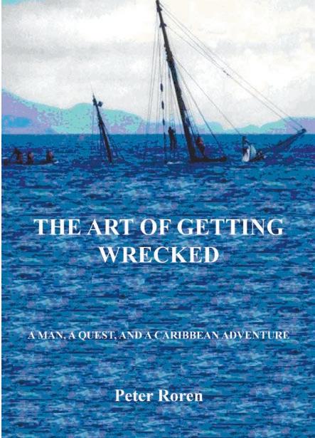
Part II of Peter Roren’s account of Hurricane Beryl, and its effect on his home island and neighboring islands, will be published in October Compass . Roren is the author of a memoir, The Art of Getting Wrecked, of which our reviewer (Nicola Cornwell, Caribbean Compass April 2020) said: “This partNorwegian, part English, mostly crazy (in a good way) author has a real-life story to tell that totally justifies the oft-used adage ‘truth is stranger than fiction,’ leaving the reader (me in this instance) muttering, ‘Blimey, you can’t make this s**t up!’ ”
TEMO·450, the first electroportable propulsion solution, is now on sale at Budget Marine St Maarten. This compact electric outboard motor weighs less than five kilograms (11 pounds) and combines motor, battery and control unit in a protective carrying case, and needs no complicated mounting or installation, so it can be used on multiple craft and in all waters. Its 450-watt motor offers 200 watts of propulsive power, enough to propel a boat in up to three knots of current. Drawing just 20 centimeters (0.6 feet), it allows an approach of any shoreline without risk of damage. It can be plugged directly into a 220-volt or 12-volt or 24-volt socket, obviating the need to remove the battery to charge it. It will give one hour of cruising speed.
Chesnee Cogswell has been promoted to sales director at BVI Yacht Sales. Cogswell has distinguished himself as a member of BVI’s sales team, a top performer and a mentor to his colleagues. His new duties as sales director will include:
• mentorship and guidance of sales team
• training and development
• strategic contributions.
For more information about BVI Yacht Sales, please visit bviyachtsales. com or contact us at info@bviyachtsales.com.
The latest addition to the annual Caribbean Multihull Challenge event in Phillipsburg, Sint Maarteen (January 30 – February 2, 2025) is the Great Bay Beach & Boardwalk Jamboree, an introduction to the town’s diverse heritage as evidenced in cuisine, music, festivals, and daily life. Here’s a preliminary schedule:
Morning: Rally fleet departs from Simpson Bay for a short downwind sail to Mullet Bay, then Great Bay and Philipsburg.
Noon: The Diam 24s, a French-built trimaran fleet, will race in hot-rod style (well past 25 miles per hour with the right breeze) heats along Great Bay Beach in the first Great Bay Checkered Flag Sailing Races.
Afternoon: Sports & Games in the new Great Bay Beach sports park, with rally crews competing for prizes.
Evening: Serious partying, with daily prize giving for the racing fleet and party festivities for all.
The Notice of Race is available and entries are already coming in; sign before November 30, 2024, to save on your entry fee.
Caribbean Airlines
Visitors to Antigua Carnival 2024
Caribbean Airlines partnered with the Antigua and Barbuda Festivals Commission/Antigua Carnival 2024 and welcomed visitors arriving at the Antigua airport with a DJ, live music by a steelpan band, and traditional carnival character, including the carnival queen. Arriving passengers also received welcome bags, and participation in prize giveaways.

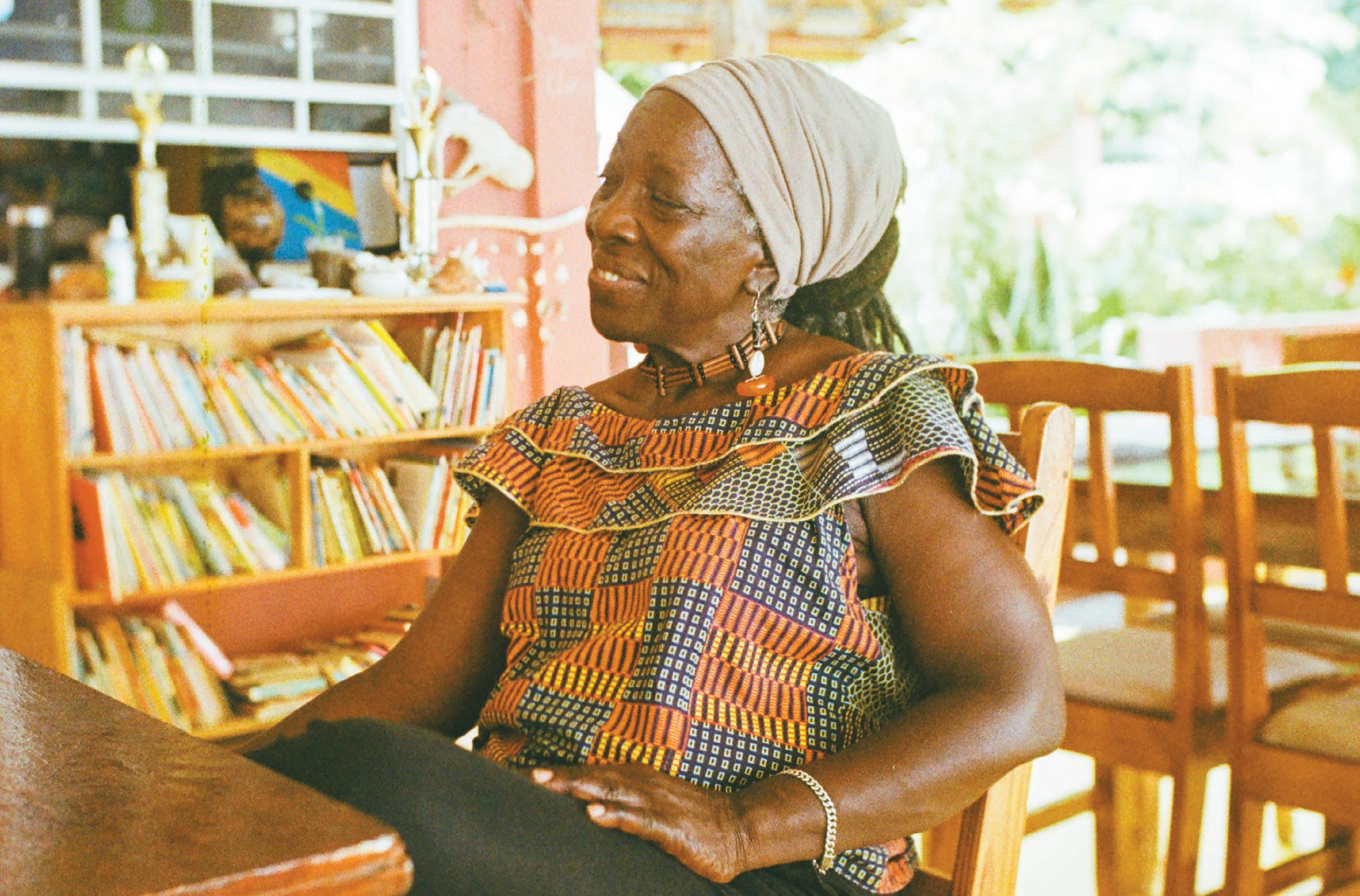
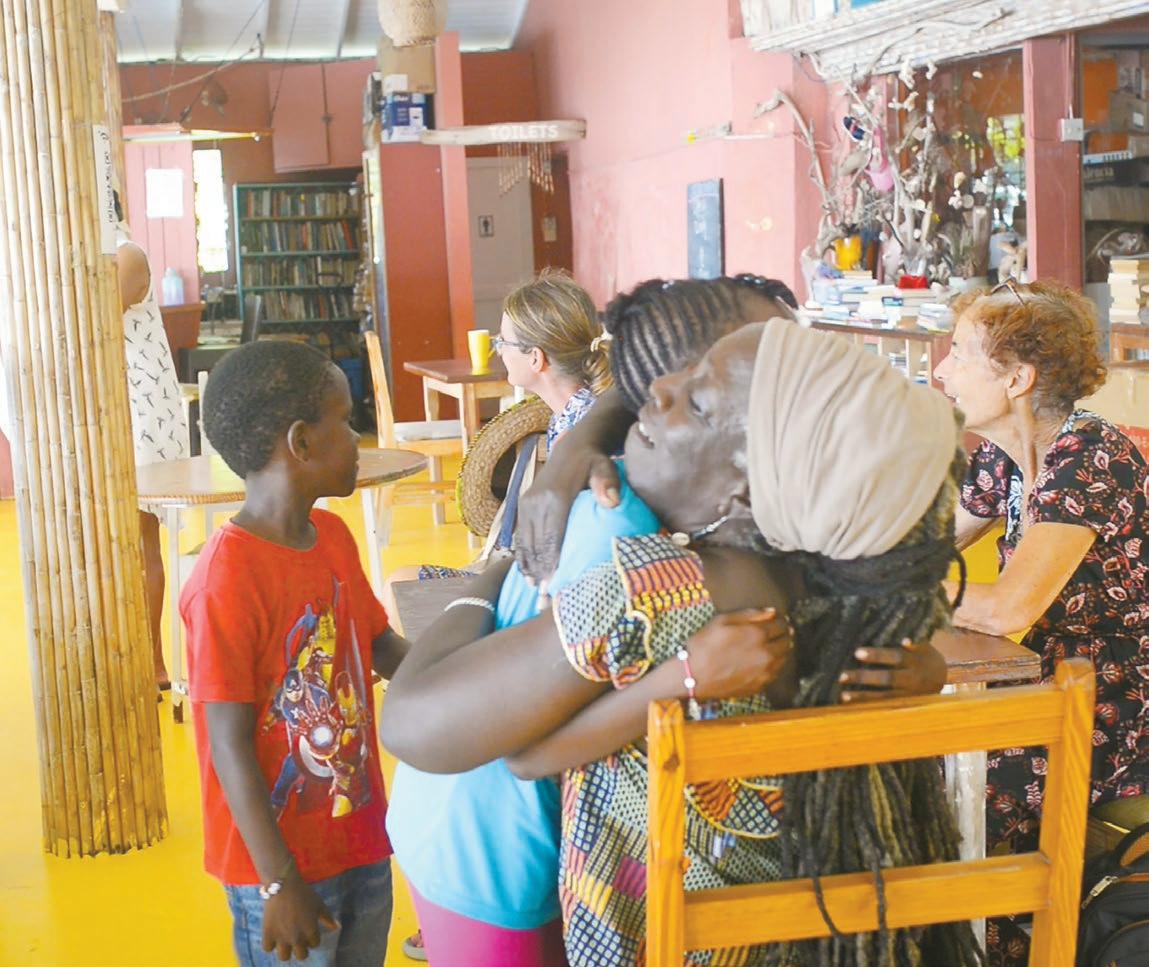
A bookcase in a restaurant? Absolutely, if it’s Cheryl Johnson’s Fig Tree.
No one who enters that bathroom at the Fig Tree Restaurant in Bequia, a tiny island in St. Vincent and the Grenadines, for the first time, expects to leave in tears. But it happens. Instead of the usual graffiti, the walls are decorated with children’s handwritten letters bearing messages of pure gratitude for “Mrs. Johnson’s reading club.”
That woman is Cheryl Johnson. She is a community leader, educator, and entrepreneur. She’s also quite busy, with two children, seven grandchildren, two great grandchildren, plus a restaurant and reading program to manage.
While Cheryl has called Bequia her home for nearly two decades, her roots trace back to the main island of Saint Vincent.
At a very young age, she became a primary school teacher but was forced to resign when she had a child outside of marriage — a regulation that was mandated under the British education system at the time.
Then, on April 13, 1979, a series of abrupt volcanic explosions blasted ash plumes 12 miles high over Saint Vincent, forcing about 20,000 people to evacuate their homes. Like thousands of others seeking refuge, Cheryl and her daughter had to relocate to Kingstown, where she dove headfirst into helping the community get back on its feet by connecting the displaced with projects and job opportunities, and equally important, she kept the spirit alive by arranging musical gatherings, igniting the soul of Vincentian culture with the smooth vibes of folk and calypso jams.
Upon Cheryl’s return to her village a year later, she decided to start a preschool for local children, which she continued until she was asked to come to Bequia to manage the island’s bookshop. It was an opportunity she couldn’t turn down, but at the same time a huge change in her life; Bequia is only an hour’s ferry ride south across the Bequia Channel, yet it feels worlds apart from the bustling industries of Saint Vincent. Bequia, no larger than seven square miles, hugs all visitors with its quaint Caribbean charm.
Steeped in maritime history dating back to the early 1800s, it became a whaling center when New England whalers introduced their techniques to Bequia residents, significantly expanding the culture and influence of seamanship.
Over the years, thousands of sailors have dropped their hooks in Bequia’s Admiralty Bay, and consequently, the Bequia bookshop catered to this transient crowd. From sailing charts, scrimshaw, and nautical flags to books about knots and marine life, the bookshop had it all.
—Continued on next page

—Continued from previous page
But as Cheryl worked in the bookshop day after day, she noticed that the local children never wandered into the store. Concerned and curious, she asked the children if they were members of the Bequia Library. They were not.
And Cheryl got an idea. “I asked the children if I were to start a reading program on the weekends, would they come?” Cheryl recalled, “And on the 19th of November, 2006, five children came.”
Seventeen years later the reading program is still going strong. Program alumni have pursued higher education and international careers, including university studies in the United States and work in Taiwan. Locally, many now contribute significantly to the community, with careers in the revenue office, post office, and tourism industry.
“I just want people to be smart,” Cheryl reflects. “If you are smart, you will reason and have discussions instead of ignorant arguments. My goal in life is to see if I can impact that into a positive.”
Cheryl’s work with the community has expanded over the years. She and her husband run the “Cruiser’s Net,” a series of local announcements on VHF radio
that broadcast to all the sailors who’ve anchored in Bequia’s Admiralty Bay. They promote local events and coordinate boat-to-boat services for gas, baguettes, laundry, ice, you name it. One could argue that it’s the most hospitable cruiser’s net in all the Caribbean.
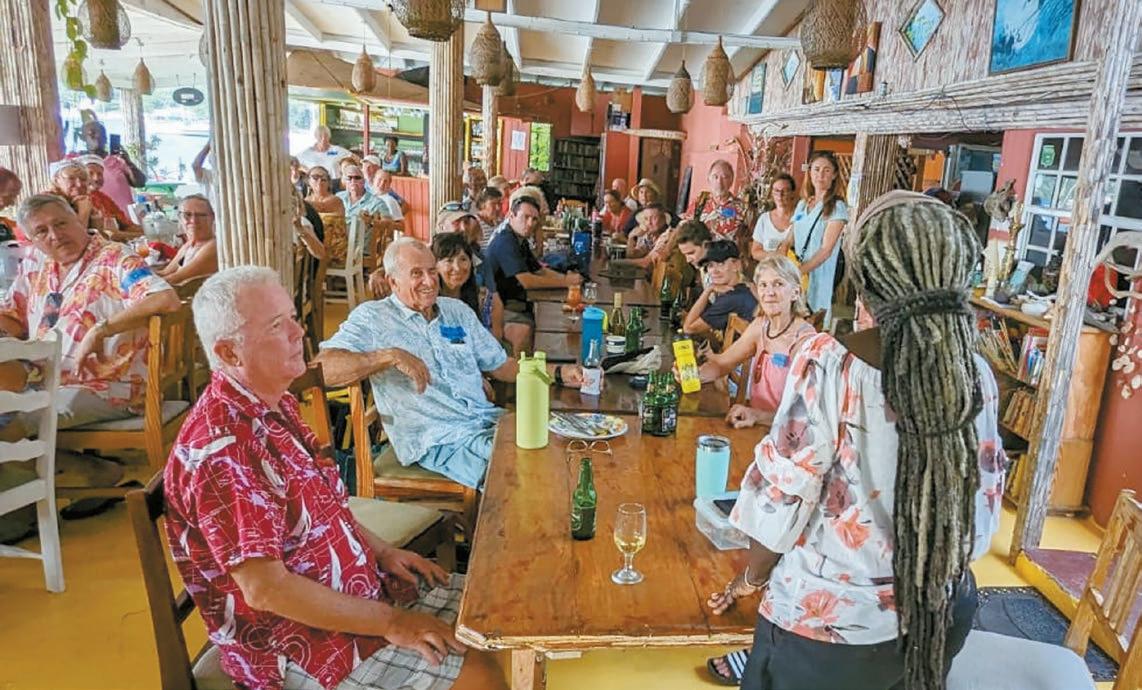
One of the largest events of the year for sailors is the Bequia Christmas Day Cruiser’s Potluck. And who hosts it? Cheryl, of course.
Niki Fox Elebaas and her husband, full-time cruisers living aboard their catamaran, S/V Grateful, helped the celebration along. “After noticing many national flags in the crowded harbor, my husband and I translated Cheryl’s invitation into Español, German, Français, and Dutch. We wound up that year with nearly 70 cruisers from all over the world gathering together to celebrate!”
And the hospitality has borne unexpected fruit. Many sailors spend their Saturday afternoons reading with the local kids. “I must give a shout out to the cruisers,” Cheryl says. “Had it not been for them, the reading program would not have survived. For all of the program’s seventeen years, when they are in the bay, they are at the Fig Tree.”
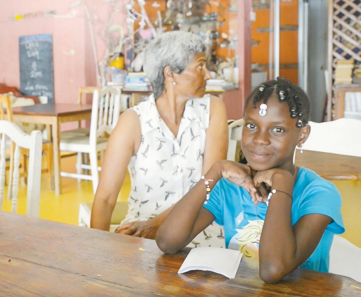
At quarter past two in the afternoon, kids start to arrive, shyly making their way to the back of the restaurant. Their faces light up with huge smiles when they see Cheryl.
The volunteers pair up with a child. And since sailors commonly visit Bequia for a month or longer, they’re able to work with the same child for multiple weeks.
Reading, comprehension, and public speaking are the three main learning outcomes of the program.
—Continued on next page
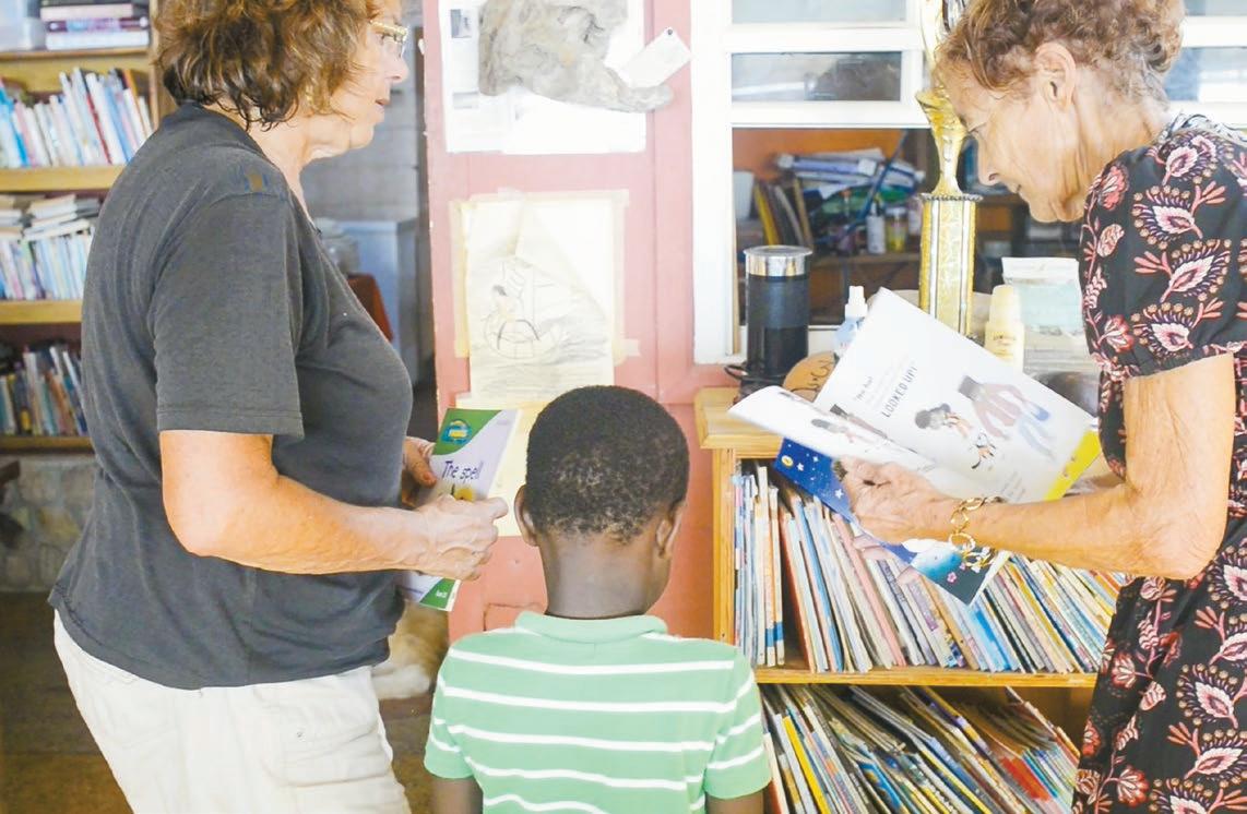
The day starts at the bookshelves, where the children get to pick their first story.
After the first book is chosen, each volunteer sits down with a child at one of the large wooden tables in the back of the restaurant.
When a child stumbles over a word or doesn’t understand a grammatical concept, the volunteer patiently explains.
Then comes recall — the children grab some construction paper and crayons.

They’re instructed to remember a scene from the book and draw it.
At the end of the day, the children make their way over to the largest table to prepare for their book report — a very intimidating task for a child, but they muster up the confidence to stand up in front of their peers and tell their story.
“I believe that word is power,” Cheryl says. “When you read, you have the power to utilize words.”
She pauses. “Additionally, and more importantly, books can take you all over the world without you getting on a plane or on a boat.”
In small societies like Bequia, Cheryl explains, children don’t always understand the ocean of possibilities that exist, and when asked what they want to be, she says, “They tell you the usual things. Hardly anybody would say that they want to be a marine biologist, and — just look around — we are surrounded by ocean.”
At the heart of the program is an impactful mission: to advance the education and prosperity of this vibrant island, starting with its children.
Reprinted with permission from BORDERLESS, which shares inspiring stories of unique individuals around the world that reveal larger universal truths of our shared humanity. There’s more about the reading program at borderlessplanet. org/projects/bequia/ – watch the short documentary, and learn how you can get involved.
On July 1, 2024, Hurricane Beryl strengthened to a Category 4 just before making landfall in Carriacou, causing unprecedented destruction to the island’s infrastructure and livelihood, as well as to nearby islands.
Although Bequia avoided Beryl’s direct path, many buildings were damaged, and one life was tragically lost. At the Fig Tree, the Johnsons faced an extended loss of electricity, causing spoilage of all their food stock. The restaurant also sustained damage to its water tanks, water pumps, roof, electrical and plumbing systems. After a temporary closure and countless hours put to repairs, the Fig Tree reopened August 17, 2024. Volunteers are encouraged to reach out and participate in the Saturday reading program and to donate supplies such as books, construction paper, and crayons for the children.

By Ed Lowrie
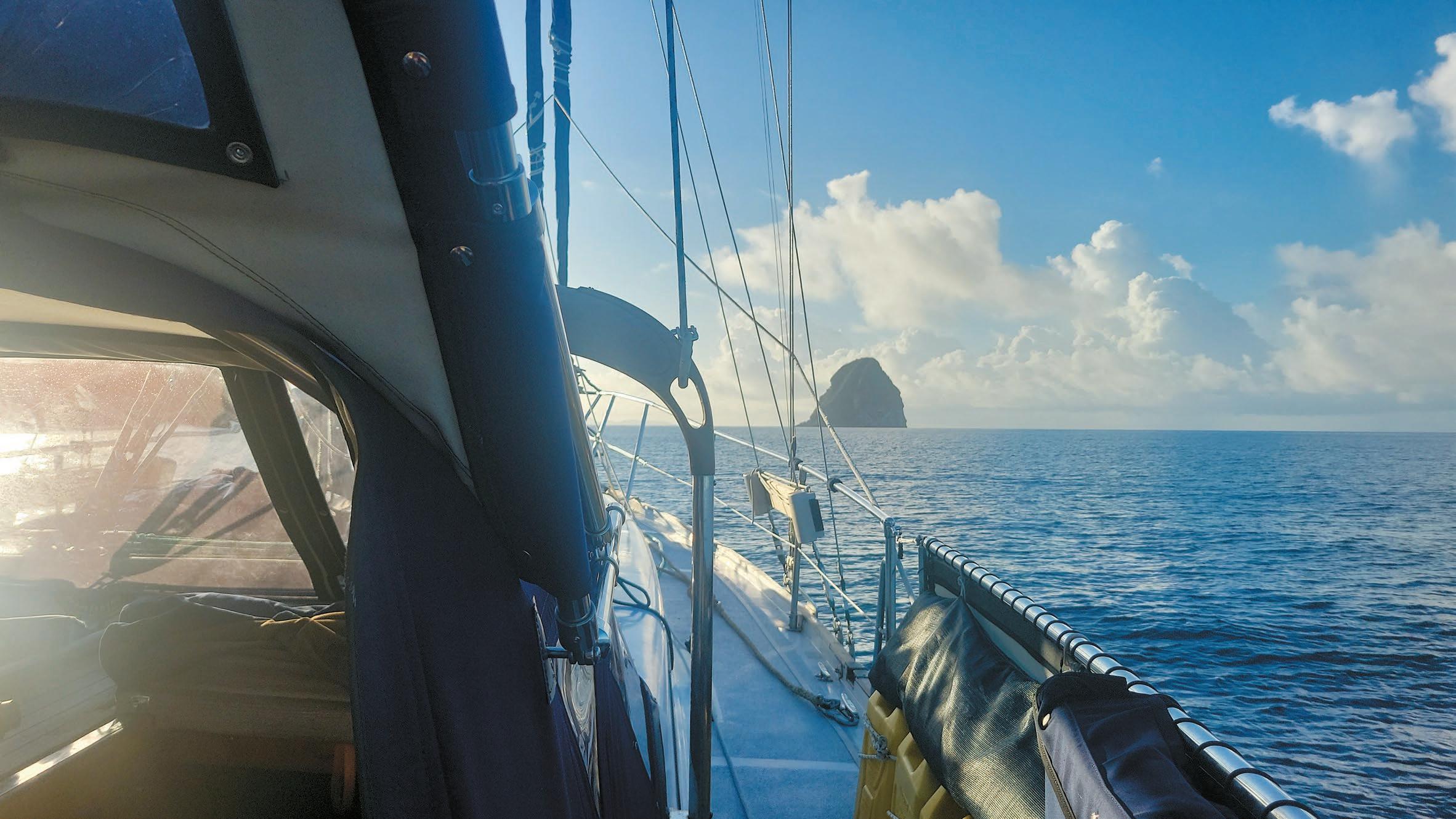
When we decide to cast off our lines and go cruising, there are many expectations, new places, new friends, new tastes, etc. We were told don’t go here, don’t go there! Trinidad was one such place and St. Lucia another. We heard lurid stories of violence and crime in the streets. We had our own expectation: We would follow our own instincts and ride our own ride.
After leaving Galveston, Texas, in the spring of 2021, we meandered around the Gulf of Mexico and up to the East Coast of the US to the Chesapeake Bay, wintering up the Rappahannock River before casting off on April 11, 2023, from Norfolk, Virginia, bound for St. Maarten — a 1,730 nautical mile, 14-day offshore sail.
St. Maarten was an absolute gem. We had some machining done to make a new steering sheave at FKG Rigging and Machining. Fast, good craftsmanship and reasonable prices. After a few weeks in the lagoon, we set out for Grand Case Bay in St. Martin, an absolute must stop anchorage on the French side of the dual nation island with some fivestar eateries. We particularly recommend L’Auberge Gourmande (laubergegourmande.com), French cuisine at its best.
to Saint-Pierre in Martinique with stunning views of Mount Pelée, a three-day stop in Anse
Noire (a must-see spot with very nice snorkeling), then down to Anse Noire to provision (stock up on wine here; it gets increasingly more expensive as you go south).
Next stop, the first of the “don’t go” there places! Rodney Bay, St. Lucia, turned out to have some of the most polite people I think we have ever met. We took a slip at the Rodney Bay Marina; the customs and immigration officers were helpful and offered great advice and assistance. The harbor master went well out of his way to accommodate us, a man that truly understands customer service.
Next port of call was Bequia, where I was to officiate the wedding of our dear friends Keith Dickey and Rebecca Frontz ( “5,000 Miles against the Trades with an Electric Motor,” Compass December 2022-March 2023). This was a surprise wedding for Becca, who had no idea until the morning of the ceremony. It went off beautifully. Keith had arranged for both sets of parents and six other guests to fly in from the US. Bequia is an awesome anchorage, great snorkeling, provisioning at Doris Fresh Food and Yacht Provisioning, and rum punch at the Lion’s Den right on the beach.
—Continued on next page

Our cat, Cali, was our sailing companion, and that meant that we if we wanted to go to Trinidad, we had to get clearance in Grenada. And Trinidad was another of those don’t go places!
But we were determined to go. The vet at the St. George’s University small animal clinic in Grenada (mycampus.sgu.edu/web/small-animalclinic/home) understood the Trinidad requirements, so we got the paperwork and took it to the chief veterinarian at the ministry in St. George’s to sign off. A word of advice: if you ever have to go to the ministry office in St. George’s: NO T-shirts. Closed toe shoes and long pants are required. Ladies must wear a skirt or dress with arms covered and, again, closed toe shoes.
If you have a pet onboard, Yacht Services Association of Trinidad and Tobago (YSATT) has a useful guide at trinidad-cruisers.com/ dogsandcats.php, which includes this chilling information: “They are very serious about the rules. A recent entry brought a cat in without the proper paperwork. The cat was put down at the airport!”
For bringing a pet in, or for any red tape involved in entering Trinidad, there is really no better agent than YSATT’s Jesse James. We had been referred to Jesse by friends, and their recommendation was seconded by Facebook sources, and by Chris Doyle and Lexi Fisher’s indispensable guide (doyleguides.com). Jesse, as the YSATT web page (ysatt.com) states, is “the person that most cruisers here turn to for help when it is needed.” In our experience, he proved to be a true gentleman, and singlehandedly the cruisers’ voice in the Trinidad government. He also operates the Members Only Taxi Service (membersonlymaxitaxi.com), runs tours and shopping trips. We highly recommend his “taste of Trini tour,” a full day tour with at least 20 different dishes from various street vendors.
A short overnight sail brought us to Chaguaramas, Trinidad. Arriving late afternoon, we took a mooring ball ($100 TT a night — about $14 USD). Clearing immigration and customs in Chaguaramas is a little different from the other islands we’ve visited; almost all others use SailClear (sailclear.com). Trinidad is old, and I mean old school. Pick up your five copies of forms, and don’t forget to place carbon paper between each copy! For all you young folk out there, carbon paper is a pre inked sheet that was used years ago to make copies. Well, it’s still in use today in Trinidad.
Sadly, shortly after arriving in Trinidad, our cat, Cali, fell off the boat and has been missing since August 13, 2023. Jesse provided relentless help and assistance in helping us find Cali, but to no avail. Losing a loved pet is always difficult, and it has taught us a big lesson: If you have a pet aboard, I urge you to have some form of tracking device. There are several different devices on the market, and I only wish we’d had one on our dear Cali.
Leaving Trinidad is going to be very difficult when the time comes, not least if it means we will be leaving our little Cali behind, but we have met some wonderful people, eaten some fantastic food, and seen some amazing sights.
Expectations met absolutely, albeit bittersweet.
Go where your desires take you and be wary of the folks who tell you don’t go there!

By David Fleming
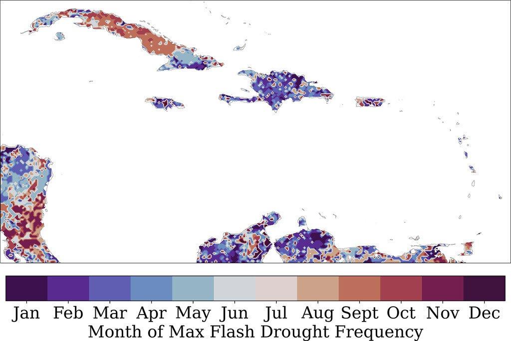
The word “drought” typically conjures images of parched soil, dust-swept prairies, depleted reservoirs, and dry creek beds, all the result of weeks or seasons of persistently dry atmospheric conditions.
In the sun-soaked islands in the Caribbean, however, drought conditions can occur much more rapidly, with warning signs appearing too late for mediation strategies to limit agriculture losses or prevent stresses on the infrastructure systems that provide clean water to communities.
Such occurrences — known as flash droughts — are the focus of a new paper authored by assistant professor Craig Ramseyer of the College of Natural Resources and Environment and published in the Journal of Hydrometeorology. The paper’s finding is that Caribbean islands are uniquely susceptible to sudden droughts, and Ramseyer advocates for alternative methodologies to more accurately measure dry conditions in the region.
“The tropics have extremely intense solar radiation, so atmospheric processes tend to be expedited,” said Ramseyer, who teaches in the Department of Geography. “Despite often receiving daily rainfall, island ecosystems are particularly vulnerable to drought conditions.”
Ramseyer, whose research focuses on tropical rainfall and severe weather impacts in the Caribbean, utilized a new drought index that considers the atmospheric demand for moisture to identify drought risk conditions, instead of more traditional soil moisture measurements.
“This new drought index is really developed to try to identify the first trigger of drought by focusing on evaporative demand,” said Ramseyer, who collaborated on the paper with Paul Miller, assistant professor at Louisiana State University. “Evaporative demand is a measure of how thirsty the atmosphere is and how much moisture it can collect from soil or plant matter.”
Ramseyer, who received funding for this research through a grant from the National Oceanic and Atmospheric Administration’s Climate Program Office, stressed that identifying drying conditions earlier is a key step to limiting the impacts of droughts.
“A lot of drought observation is based on soil moisture, but, in tropical environments, a decline in soil moisture is a response to other things that have
already happened, so you’re further down in the chain of events,” he said. “We can mitigate a lot of losses in, say, agriculture, by being able to forecast sudden, anomalous increases in evaporative demand.”
The impacts of drought conditions extend beyond agriculture: tropical ecosystems are also strongly impacted by dry atmospheric weather conditions, and access to fresh water is a necessity for both communities in the region and a tourism industry that is a central driver for economies in the Caribbean.
To better understand how that interplay of meteorological patterns impacts drought conditions, Ramseyer utilized 40 years of data from a long-term ecological research project in the El Yunque National Forest. He found that flash droughts have routinely occurred in the Caribbean, and that occurrences of drought are not limited to traditional dry seasons on the island.
“In terms of climate, Puerto Rico is situated at a crossroads, buffered on the west by the El Niño southern oscillation and by the cooler North Atlantic oscillation on the east,” said Ramseyer. “Because of that, Puerto Rico has a unique geography for researching atmospheric changes.”
The looming concerns over global warming have only accelerated the need for meteorologists to better understand drought occurrences in the Caribbean and enhance monitoring of moisture conditions in the region.
“A warming planet results in more moisture available in the atmosphere overall, which means that the kinds of short-term precipitation events common to the Caribbean will increase in intensity,” said Ramseyer. “Meanwhile, droughts are becoming higher in magnitude so climate change is altering both extremes.”
Ramseyer, who helped secure Virginia Tech’s membership in the University Corporation for Atmospheric Research this year, noted that developing clearer criteria for flash drought conditions is an important first step towards addressing the infrastructure challenges that Caribbean communities are likely to face.
“The key current and future issue for the Caribbean is all about finding a way to capture rainfall successfully and draw it out slowly to mitigate evaporation losses,” said Ramseyer. “Puerto Rico and all of the Caribbean have water infrastructure challenges that must be addressed to accommodate these trends.”
Geography Department chair Tom Crawford said that Ramseyer’s paper uses big data in tackling climate and meteorological challenges.
“Dr. Ramseyer’s research applies advanced computing and geospatial science to make significant contributions to the problem of flash droughts and precipitation variability broadly,” said Crawford. “In addition to his research impact, his course on Climate Data Analysis and Programming is training the next generation of researchers on cutting edge computational techniques applied to the changing climate.”
Ramseyer advocates for additional research into understanding the relationship between flash drought events and economic losses, and how future drought events can be better communicated to stakeholders and communities.
Reprinted with permission from Virginia Tech News.
By Amanda Delaney
Ocean currents are found circulating around the world. These currents help regulate the Earth’s climate by distributing heat and moisture worldwide. If ocean currents did not exist, then temperatures would become more extreme with excessive heat in the tropics and cold air remaining over the polar regions. The main current that is found in the Caribbean Sea is known as the Caribbean Current. We’ll discuss its importance and how it contributes to the rest of the Atlantic Ocean circulation.
The Caribbean Current, a confluence of several currents from the Atlantic, flows in a general east-southeast to west-northwest fashion across the Caribbean, eventually extending into the Gulf of Mexico. This then feeds into the Loop Current in the Southern Gulf of Mexico, and then into the Gulf Stream south of Florida and off the U.S. East Coast.
The Caribbean Current originates from the tropical Atlantic Ocean. The strongest currents generally flow along northern Brazil and northeastern South America. These warm currents eventually flow through the southern Windward Islands and move northwest over the southern Caribbean Sea. At times large clockwise eddies will form to the north of the Guiana Current and move northwest toward the Lesser Antilles. These eddies will reach the northern Windward and Leeward Islands and will eventually absorb through passages between the islands into the Caribbean (Figure 1 displays the Caribbean Current during the winter).
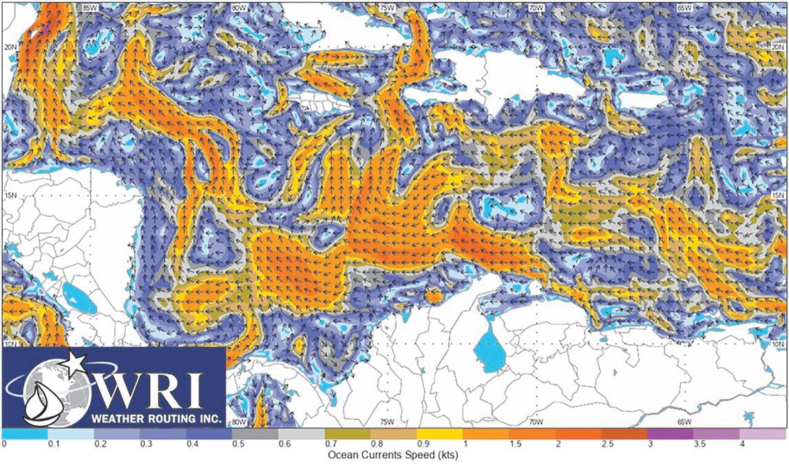
Farther east and north, the North Equatorial Current that flows from east to west over the Atlantic Ocean will filter through some of the island passages over the northern Lesser Antilles. However, much of the current will lift to the north of the Greater Antilles (Puerto Rico, Hispañiola and Cuba), becoming the Antilles Current. This current will continue up through the Old Bahama Channel and will merge with the Gulf Stream.
Upon reaching the Western Caribbean, a portion of the Caribbean Current branches off and splits southward to form the Panama-Colombia Gyre, a broad “cyclonic” (counterclockwise in the Northern Hemisphere) current that covers much of the southwest Caribbean, flowing southward along the southeast coast of Nicaragua, eastward along the Caribbean coasts of Costa Rica and Panama, northeastward along the coast of Colombia, then westward to pass just south of the main Caribbean Current flow from which it branches off. This is a semi-permanent feature, showing little overall change in coverage, influenced otherwise by the continuous presence of smaller-scale eddies travelling within the Caribbean Current.
Sea surface temperatures in the Caribbean average about 80°F (27°C) and usually vary approximately three degrees throughout the year. As one might expect, the coolest sea surface temperatures occur in the winter and the warmest in the summer. Sea surface temperatures have increased one to two degrees above normal across the Caribbean Sea, and one to three degrees in the Atlantic Ocean and Gulf of Mexico starting last summer. This was one of the factors that led meteorologists to predict a higher than normal frequency of tropical cyclones in the Atlantic Ocean this year.
Salinity generally ebbs and flows in one cycle per year as well, reaching a minimum in early winter and a maximum in early summer. During mid to late summer and fall (August into December), the Caribbean Current diminishes following the arrival of freshwater discharge from the Amazon and Orinoco Rivers. a process which reverses itself as increased heating from the sun into spring yields increasing sea surface temperatures and evaporation at the surface, leaving minerals and salts behind. This forces the saltier water beneath the ocean surface, increasing currents, and eventually yielding the arrival of freshwater to repeat the cycle for another year.
How do extreme weather events, such as tropical cyclones, impact the Caribbean Current? Tropical storms or hurricanes can mix deeper in the ocean waters. At times, larger hurricanes that move slowly can draw up cooler waters from deep beneath the surface, a phenomenon known as “upwelling.” The thermocline, or the boundary where warmer sea water and cooler sea waters meet, is located well beneath the surface.
—Continued on next page
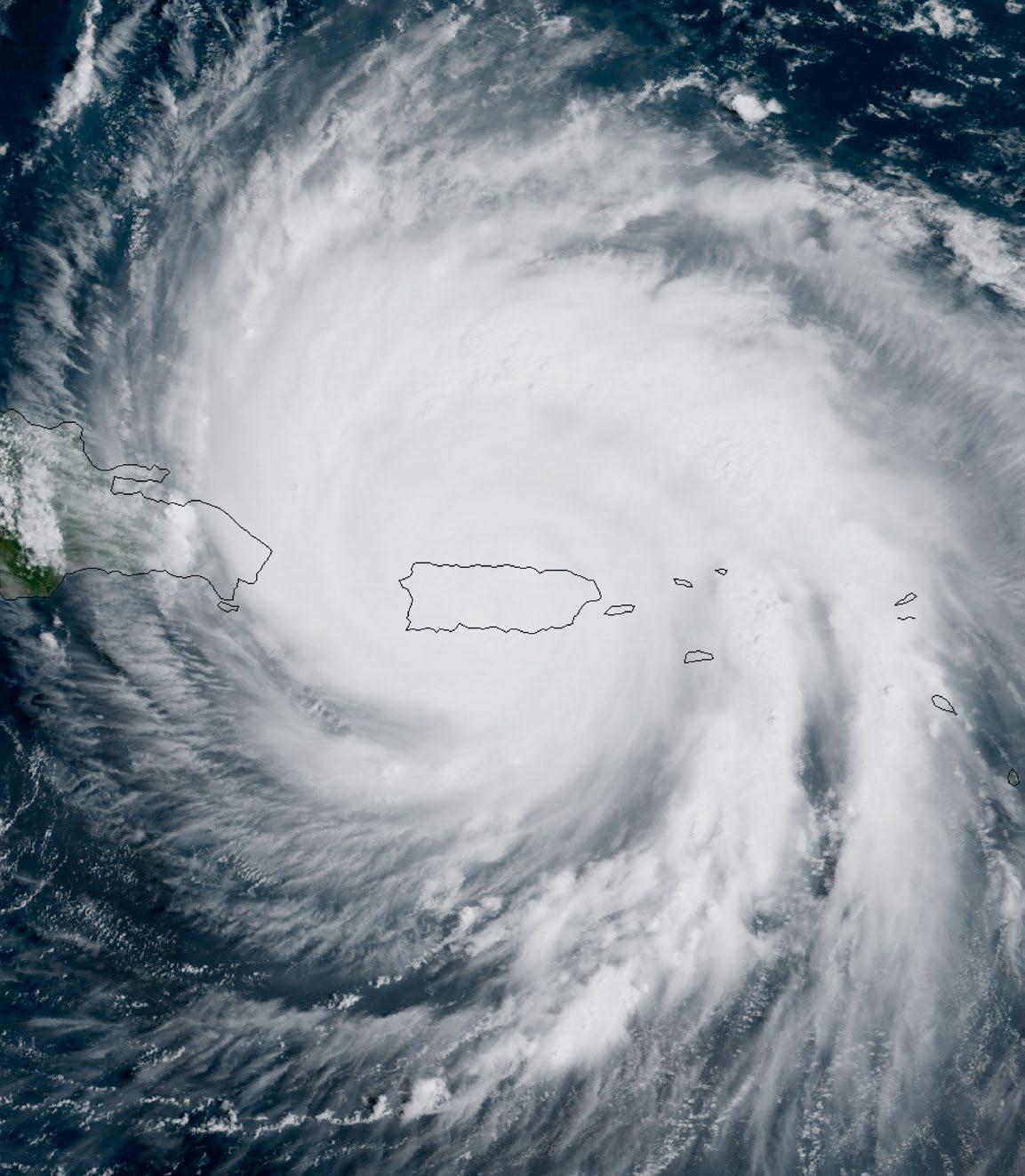
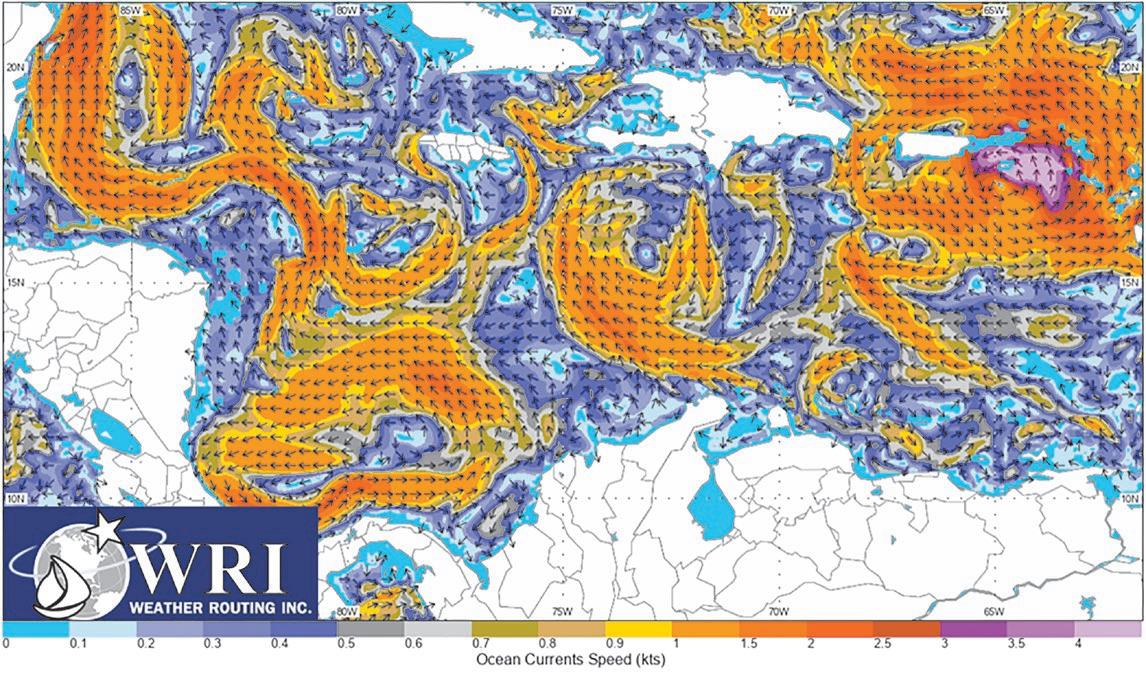
Tropical storms and hurricanes can disrupt surface currents but overall will not impact deeper ocean currents in the Caribbean Sea, which generally move quickly east to west. A hurricane’s winds can, however, create a cyclonic current that will flow away from the center of the sea surface circulation. An example of this can be found in figures 2 and 3 of the NOAA satellite image of Hurricane Maria in 2017 and the associated Real-Time Ocean Forecast System (RTOFS) currents located near the hurricane at the same time. Although tropical storms and hurricanes will damage marine environments, the deeper turbulence in the wake of these systems can stir up nutrients from deeper waters. This will draw marine life back into areas where the nutrients reach closer to the surface.
Drier weather can play a role across the Eastern Caribbean as well. There are times when strong easterly winds will blow large areas of dust from the Sahara Desert. These plumes of dust can remain intact across the tropical Atlantic Ocean and can reach the Caribbean. This dust and dry air will actually inhibit thunderstorm development and, when occurring during the tropical cyclone season, usually hinder any tropical cyclone activity in the region. This dust can carry nutrients and minerals that eventually fall to the ocean surface.These abundant nutrients, as well as less cloud cover, can help microscopic plants to develop and can lead to algae blooms over the Western Tropical Atlantic Ocean and Caribbean Sea.
The Caribbean Current assists in distributing Atlantic tropical waters and freshwater from major South American rivers back north toward the Gulf of Mexico and Western Atlantic Ocean. The salinity, sea surface temperatures and nutrients impact marine life across the Caribbean Sea. Prevalent winds over the Caribbean waters can draw up moisture that will influence the weather across the region and, in some cases, tropical cyclone development. This current is just one of many that contribute to the entire North Atlantic current.
Amanda Delaney is a senior meteorologist at Weather Routing Inc. (WRI). WRI provides customized forecasts and online weather services to mariners worldwide.


Story and photos by Darelle Snyman
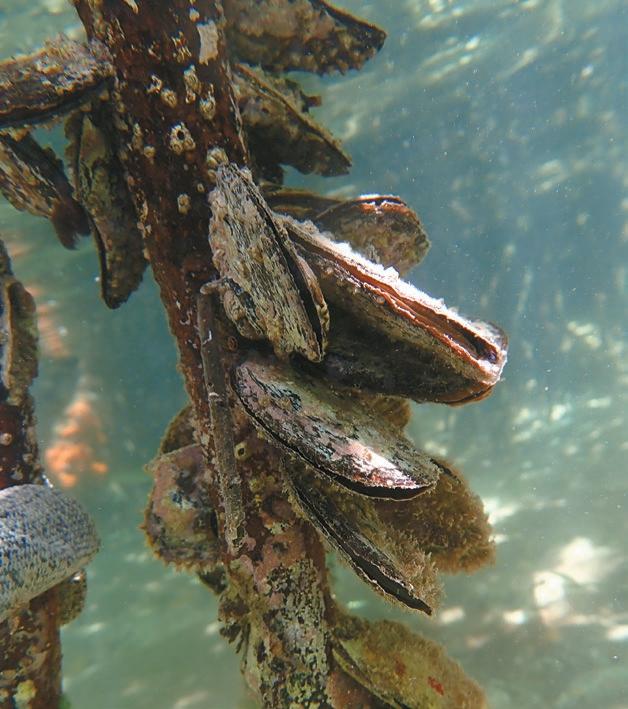
The Caribbean Sea is known for its diverse marine life, and among the countless creatures that inhabit this underwater paradise are the bivalve mollusks. These mostly overlooked creatures live their lives hidden between two hinged shells or valves. In the grand scheme of marine life they do not attract a lot of attention unless they end up on your dinner plate, yet they have established themselves as crucial role players within the marine ecosystem, having an enormous impact as water filters in the habitats they frequent. Bivalve mollusks have graced our planet with their presence for millions of years and boast an astonishing level of diversity. From the familiar oysters, clams, scallops, and mussels to the more obscure, these creatures are found in a wide range of habitats which has led to a variety of specialized lifestyle adaptations. So let’s meet some of these two-shelled organisms that call the Caribbean home.
I will start off with the resident most likely to attract attention, the rough file clam (Ctenoides scaber), also known as the flame scallop (although, as a member of the family Limidae, it is not closely related to true scallops). Its vivid red mantle, fringed with a mesmerizing display of red or white tentacles, captures attention and makes them attractive photography subjects. The vibrancy of their mantle is the result of high levels of carotenoids in their body. These relatively abundant bivalves can be found wedged into crevices or resting in their own nest made from small coral pieces and rocks. They only eat phytoplankton, which they painstakingly sort through, selecting only the best morsels.
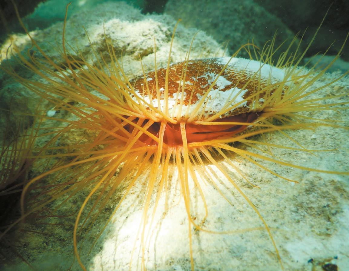
Unlike many of their kin, these bivalves are able to move around by clapping their valves together; and they can, when the need arises, propel themselves out of harm’s way from predators such as crabs and shrimps.
Another file clam you might swim into is the Antillean file clam (Limaria pellucida), a small file clam with a salmon pink mantle fringed with long pink to reddish tentacles, often bearing faint white bands. Its pale coloring differs starkly from the vibrancy of the flame scallop, so confusion between the species is unlikely.
An interesting bivalve I encountered in Bocas del Toro, Panama, hiding among turtle grass, is the amber pen shell (Pinna carnea), a delicate beauty with a fragile shell that comes in shades of amber or light orange. What makes these bivalves unique is that they burrow into the sandy substrate as they grow with only the wide, posterior ends of their triangular shells exposed to facilitate filter feeding. Like many of their kin they also rely on protein filaments called byssal threads to anchor themselves firmly. They can reach 30 centimeters (12 inches) in length and in their exposed position, their delicate shells are easily damaged, often showing breaks and scars. They do,
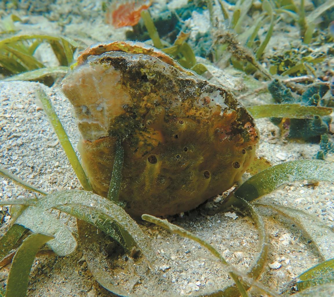
however, possess an incredible ability to repair their shells. Studies have shown that the mantle, which secretes the shell, can repair over 3 millimeters in 24 hours. Their sedentary position means that their exposed valves soon become colonized by algae and other sessile invertebrates, which provide additional protection and camouflage. They not only act as a growth substrate for other organisms but may also host a number of symbionts within their mantle cavity. Critters such as anemones, cardinal fish, pea crabs and shrimps have been found sheltering inside these amber valves.
The Atlantic thorny oyster ( Spondylus americanus ) is another bivalve resident whose shell hosts a variety of epibionts such as barnacles, sponges, and hydroids. You will find these solitary bivalves firmly cemented to rocky substrates where they will stay unless dislodged by a storm. Their most striking feature is the profusion of spiny projections covering their upper valve, creating the ideal microhabitat for other species. In spite of their common name, these spiky individuals are not closely related to true oysters but rather to scallops. Their valves are joined with a ball-and-socket type of hinge, whereas most bivalves have a toothed hinge joining their shells. Like scallops their white blotched, brownish mantle is edged with eyes. These are not true eyes, but rather light sensitive spots that detect changes in movement and light intensity, allowing the oyster to quickly close its shell. These eyes might not give them a view of the world around them but are essential to their survival.
Another master of camouflage is the frond oyster (Dendostrea frons ). Because their sturdy shells provide a hard substrate for other organisms to grow on, their shells are often covered in algae and other organisms. This keeps them safe from predators while also contributing to a greater biodiversity in the life of a reef. They can mold their shells to conform to the shape of their surroundings, further allowing them to seamlessly blend into the environment. They seldom exceed two inches in size and the key to their identity is the distinctive saw-toothed edges of their valves. Frond oysters are true oysters, belonging to the family Ostreidae, which include all the commonly consumed oyster species. Frond oysters, however, are not widely consumed, even though they are considered a delicacy, having an apparently milder and sweeter flavor than their popular counterparts. Their role within the reef ecosystem makes them valuable reef residents, so they are afforded protection by strict harvesting regulations.
—Continued on next page
Atlantic wing oysters (Pteria colymbus) in turn belong to the Pteriidae family, the bivalves renowned for producing economically important pearls as a result of their natural defense mechanism against irritants. They secrete a calcium carbonate “pearl sac” to isolate irritants that lodge in their mantle folds. These distinctive bivalves get their name from the wing-like extensions on its shell called auricles. The auricles on adult shells tend to be less pronounced than those of younger individuals. Although found attached to a variety of substrates by their strong byssus threads, they are commonly found living in association with sea whips and other gorgonians to maximize access
to the currents. Their shells are typically brownish, with rays of lighter colors, and often covered with a matted brown, fur-like covering called the periostracum. The interior of their shells tends to be a shiny pearly gray. During spawning they obscure the water with thousands of eggs and sperm and a female can produce more than a hundred million eggs yearly. The young oyster that develops from a fertilized egg glues itself onto a suitable hard surface where the now-called spat matures.


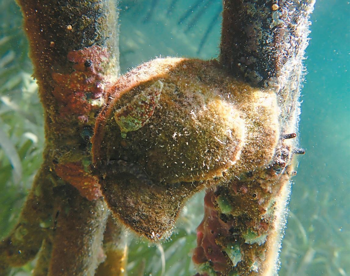
To find our last bivalve, the flat tree oyster (Isognomon alatus), you have to venture closer to shore as these individuals prefer to attach themselves in clusters to the stilt roots of red mangrove trees. Their flat profile, as indicated by their common name, is an adaptation to their tree-dwelling lifestyle where they can cluster together in great numbers. The exterior of the valves are rough and sculpted by concentric circles which give information about the oyster’s growth and age, much like tree rings. The interior contrasts greatly with their rather dull exterior, being a lustrous, cream-colored nacre. These unassuming bivalves make an important contribution to the overall health and balance of mangrove ecosystems, which are among our most vital coastal habitats. Serving as a food source for various predators, they are also an important component of the marine food chain.
Flat tree oysters prefer to attach themselves in clusters to the stilt roots of red mangrove trees.
It is clear there is more to these underestimated architects of the marine ecosystem and their significance is underscored by their role as filter feeders, habitat providers, and food sources. I hope you enjoyed this glimpse into the lives of these uniquely adapted marine critters.


by Nigel Calder and Jan Athenstädt
Editor’s note: With this debut column about power conversion, Caribbean Compass welcomes the creators of BoatHowTo, Nigel Calder and Jan Athenstädt. For more in-depth knowledge about boat systems, check out their articles and courses at BoatHowTo.com.

In the United States, when you plug into an outlet in your house or on a boat you are plugging into a 120-volt circuit. In Europe, when you do the same thing, you are plugging into a 230-volt circuit. Let’s say we are plugging in a microwave with a power rating of 1,000 watts (W). Watts are a function of volts multiplied by amps. We can turn this around to say the amps required to power the microwave are determined by dividing the supply voltage into its watt rating.
You are probably wondering where we are going with this! Well, that 1,000watt microwave is going to pull 1,000W/120V = 8.33 amps in the US whereas in Europe what is effectively the same microwave will pull 1,000W/230V = 4.35 amps. Basically, half the amps.
When we wire a circuit, the size of the conductors is in part determined by the maximum number of amps that will flow through the circuit. For a given power level, a US boat requires conductors that are considerably larger than a European boat wired for the same power level.
European-built and American-built boats are, in fact, wired for very similar power levels. The most common U.S. shore power connection is for a 30-amp circuit @ 120V; 30A x 120V = 3,600W. The most common European connection is for a 16-amp circuit @ 230V; 16A x 230V = 3,680W. The two boats will be able to power devices that require the same level of power, but the European boat can do it with considerably smaller conductors.
If we now bring this European boat with a 16A shore power circuit to the U.S. and plug it into a 30A shore power circuit and run this at the full rated 3,600 watts, the onboard wiring will be substantially undersized. It is likely to melt
Time Out Boat Yard Saint Martin Next to the French Bridge

down and start a fire. But if we take the U.S. boat with a 30A shorepower circuit to Europe and plug it into a 16A shore power circuit and run this at the full rated 3,680 watts there will be no problem. The wiring is oversized but that’s OK.
You cannot bring a European-wired boat to the U.S. and expect to plug it in unless the boatbuilder specifically upsizes the wiring for the lower U.S. voltage. You can, on the other hand, take a U.S. wired boat to Europe and plug it in without any overheating issues. However, you will destroy the onboard equipment with the higher voltage unless you step the voltage down to 120 volts with a transformer. Even then you will run into another entirely different problem: frequency incompatibility.
Shorepower is known as alternating current, or AC for short. The voltage and amperage cycle back and forth from positive to negative in relation to the earth. The rate at which they cycle (known as Hertz, or Hz) differs between Europe and North America. In Europe it is 50 times a second and in North America 60 times a second. Let’s say we have taken our U.S wired boat to Europe and we have a 230V to 120V transformer, so the conductors are adequately sized, and we have the correct voltage for our U.S. equipment. There will still be a frequency mismatch. Some of our U.S. equipment won’t care, some of it will be designed for both frequencies, some of it will run but not well, and some of it will be wrecked!
This all gets especially complicated in the Caribbean because some ex-British Islands have North American 120V/60Hz power (e.g., the British Virgin Islands), and some British (i.e., European) 230V/50Hz power (e.g., Bequia). It is really important to check before plugging in. And then, of course, there are a wide variety of outlet configurations and plugs, but that’s a whole additional story! There is a simple and economical workaround to these issues for both the European and U.S. boat. If all the AC equipment on the boat is powered by a DC-to-AC inverter, the only piece of equipment that needs to be connected to shorepower is a battery charger. The battery charger will feed the DC input side of the inverter, and the inverter will power the AC circuits. You can buy marine battery chargers that will accept as the AC input anything from 90V to 270V, and anything from 45Hz to 65Hz -i.e., a ‘universal’ AC input. So long as your shorepower cord is sized to handle the lower U.S. voltage, you can plug in anywhere in the world and use all the onboard AC equipment. I have done this for years. It works like a charm.
Note: A good source for voltage and frequency around the world is https://www.generatorsource.com/ Voltages_and_Hz_by_Country.aspx
For more details watch this YouTube video: https://youtu.be/0Cq_5CP4PWs?si=6iB2_VoBRbkfW97v
Published with permission of Boathowto.com.


By Jim Ulik
“… the moon’s night receives just as much light as is lent it by our waters as they reflect the image of the sun, which is mirrored in all those waters which are on the side towards the sun.” Codex Leicester, circa 1510, Leonardo Da Vinci.
Da Vinci believed that the Moon had an atmosphere and oceans that reflected the Sun’s rays. He also thought that the illumination of the dark side of the Moon was due to reflected light from Earth’s oceans. Some hold the current belief that the faint view of the dark side is because the Moon is translucent. Not true. While water is a great reflector, clouds actually reflect most of the light illuminating the night side of the Moon. That is called Earthshine.

Sunday, September 01
Jupiter and Mars will lead a procession of planets that begin to rise in the east just after midnight. As dawn starts to break, Mercury can be found rising five degrees south of the fine crescent Moon. Notice the glow on the dark side of the Moon from Earthshine.
Monday, September 02
The Moon would appear almost in line with the Sun today if you could see it. Don’t try to find it unless you want to make a visit to an ophthalmologist for a retinal scan. Instead use the nighttime hours to observe the stars during the New Moon.
Wednesday, September 04
This morning the Aurigids meteor shower is coming to an end. An hour or more before sunrise this shower may still produce up to 10 meteors per hour radiating out of the northeast sky. A short time later Mercury can be seen rising above the eastern horizon. The fast-moving planet, messenger of the gods, reaches its highest altitude in the morning sky. Tomorrow Mercury reaches its greatest western elongation of 18.1 degrees from the Sun.
Thursday, September 05
The Moon, Venus and Spica appear in the western sky after sunset. The trio line up in the constellation Virgo with the blue star Spica located southeast of the Moon. Venus is situated towards the north and south of the Moon.
Monday, September 09
Mercury can be seen closing in on the heart of the constellation Leo on September 08. On September 09 Mercury is positioned less than one third of a degree north or left of Regulus. Look for planet Mercury to outshine the 21st brightest star in the entire sky.
This evening a few shooting stars may be seen radiating out of the northeast. This is the peak of the September epsilon Perseid meteor shower. The best time to spot meteors streaking across the sky is after 2200 hours.
The Sun will shine directly over the equator throughout the day rising at 90 degrees and setting at 180 degrees. With a full 12 hours of sunlight it might be a good time to think about making an angular adjustment to your solar panels for the coming winter.
The Moon is passing by Pleiades this morning. However, viewing the Seven Sisters will be better tomorrow because they will be positioned off the dark side of the Moon.
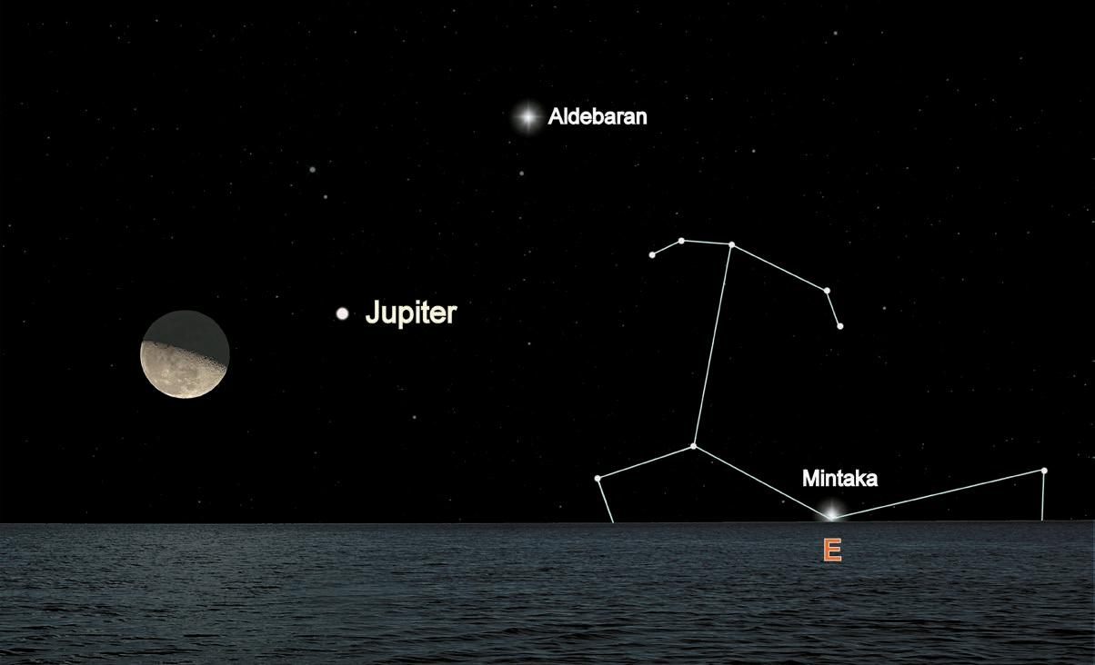
Conjunction of the Moon and Jupiter just before midnight on September 23
Saturn is at opposition over the next few days and brighter than any other time of the year. The ringed planet will also be at its closest approach to Earth.
Tuesday, September 10
The Moon has slipped through the claws of Scorpius and passed over Antares as it approaches its First Quarter phase. The Moon tonight may appear in its first quarter phase but that moment will actually occur when it is high over the South Pacific. By the time it rises over the Caribbean on September 11 it will be a waxing gibbous Moon and 55 percent illuminated.
Tuesday, September 17
It’s midnight and the Moon already crossed the Meridian and is closing in on Saturn. The pair will get closer as they draw near the western horizon with one degree of separation.
This evening the Moon will dim slightly due to the partial lunar eclipse. The Earth’s shadow begins to touch the Moon at 2041h. At 2212h the Moon starts to get a reddish hue as the partial eclipse starts. The Moon reaches its Full Moon phase at 2234h. Ten minutes later the maximum eclipse occurs. The eclipse will finally end Wednesday morning at 0047h.
Wednesday, September 18
The Moon will appear larger as it rises this evening. It is only an illusion that makes the Moon appear larger at the horizon. In addition to the increased apparent size due to the Moon illusion the Moon will also reach the closest point along its orbit to the Earth.
Sunday, September 22
Astronomical summer is over. Today is the first day of autumn for us in the northern hemisphere.
Monday, September 23
Just a heads up! The comet C/2023 A3 (Tsuchinshan-ATLAS) is becoming brighter in the pre-dawn sky. In five days it will reach its highest orbital point in the east southeast sky. The best time to view the comet over the next few days will be between 0500h and 0530h. The tail could stretch about six degrees across the morning sky.
The Moon and Jupiter will make a close approach, passing within five degrees of each other. See Image 2. Jupiter will be the first to rise in the ENE (66 degrees) followed five seconds later by the Moon (61 degrees). An aid to finding directions is the star Mintaka. The star is the westernmost star in the belt of Orion. It rises due east everywhere in the world and rides along the celestial equator finally setting due west.
Wednesday, September 25
The Moon left Jupiter behind and tonight takes up position with Mars. Extending a line that separates the light and dark side of the Moon will point directly to Polaris, the north celestial pole. The number of degrees Polaris is above the horizon equals the latitude of the observer.
Friday, September 27
Two celestial events take place this morning before sunrise. Comet C/2023 A3 is making its closest pass to the Sun. It will continue to get brighter over the next week. The constellation Sextans, the Sextant, is above or west of the comet. The sextant is also the radiant point of the Daytime Sextantids meteor shower. The shower peaks this morning and is active September 07 – October 08. The meteors will enter Earth’s atmosphere at 115,200 km/h (71,582 mph).
*All times are given as Atlantic Standard Time (AST) unless otherwise noted.
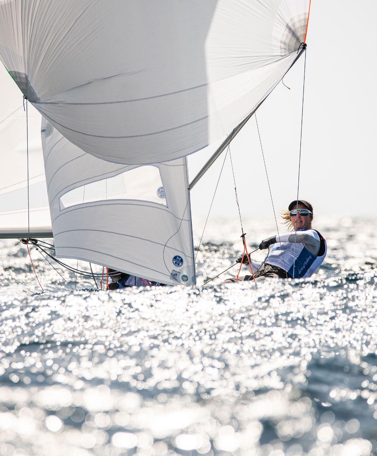


Crossing the channels between Eastern Caribbean islands, an ebb tide carries you off to leeward and a strong flood tide creates lumpy seas, so crossing with a favorable tide is faster and more comfortable. The table below, showing the local time of the meridian passage (or zenith) of the moon for this month, will help you calculate the tides.
Water generally tries to run toward the moon. The flood tide starts running eastward soon after moonrise, continues to run east until about an hour after the moon reaches its zenith (see TIME below) and then ebbs westward. From just after the moon’s setting to just after its nadir, the tide runs eastward; and from just after its nadir to soon after its rising, the tide runs westward.
The first hour after moonrise, the westerly current is barely negated. The second hour the flood tide is stronger, the third and fourth hour it’s strongest, then it eases off in the fifth and sixth hours. The maximum tide is three or four days after the new and full moons. For more detailed information enabling the sailor to calculate the direction and strength of the current, check the tidal section in the booklets that come with Imray-Iolaire charts A27 or B1.


St. Kitts and Nevis are two distinct islands under a single country. St. Kitts has a large cruise ship port, a bustling waterfront shopping mall, and activities that cater to the 4,000-some daily cruise ship visitors during the tourism season. Nevis is a little quieter, with some excellent restaurants, an interesting history and sites well-preserved by an active historical society.
St. Kitts is green and pleasant, with a steep central mountain range rising to 3,750 feet. Much of it is covered in rainforest, which is often shrouded in passing clouds. The land between the mountains and the sea is sloping and fertile, relatively flat, and easy to drive on. For many generations this was planted in sugar cane, which was abandoned years ago; the cane fields are slowly reverting to woodland.
The Caribs called St. Kitts “Liamuiga,” which means “fertile isle.” Columbus renamed it after his patron saint. Sir Thomas Warner landed here with a group of settlers in 1623, making it the first British Caribbean colony. A French group joined them, and the two nations teamed up to massacre the 2,000 Carib inhabitants before they fell out between themselves. After 150 years of fighting and uncertainty, St. Kitts and Nevis became British under the treaty of Versailles in 1783. Today it is a fully independent state with a British tradition and about 50,000 inhabitants. The economy, once based on sugar cane, shifted to tourism in 2005.
A railway, built for collecting the sugar cane, once ran right round the island. St. Kitts Scenic Railway renovated part of this so you can take a rail tour. Book well in advance (465-7263).
In the north, St. Kitts Marine Works haulout, with its Telca Marina under Brimstone Hill, is working and practical. In the south, Christophe Harbour, an upmarket marina and development, is open. A Budget Marine chandlery is there. For a while the customs and immigration procedures were simplified, and the yachting industry was looking up. Unfortunately, St. Kitts and Nevis has recently resurrected the eAPIS regulations, and some officers insist you fill out this additional online form when clearing in. The big local race is the three-day Booby Island Regatta, which includes such races as Chase the Monkey and a round Nevis race called “Round the Rock.”
Nevis is less than two nautical miles south of St. Kitts, and looks like a sombrero, peaked in the center and low around the edges. Clouds usually cap Nevis Peak, which is over 3,000 feet high. On occasion, they cling to the summit and fall down the sides. Some say this is why Columbus named it “Nuestra Señora de las Nieves” (Our Lady of the Snows), after one of his favorite churches.
Early attempts were made to settle the island from St. Kitts in 1628. The first town, called Jamestown, was built near Fort Ashby, but it sank into the sea after an earthquake and tidal wave in 1680. Various battles between the British and the French hampered development until 1783, when Nevis became British for an extended time. It flourished as a plantocracy, and there are many old plantations and sugar mills on the island. The old mills are crumbling, but the plantations have been converted into hotels..
With a population of around 11,000, Nevis is quiet and peaceful, with lovely views, picturesque houses, and delightful people. Exploring the island is highly recommended. Nevisians have been careful to preserve their architectural heritage and many traditional Caribbean-style buildings survive. Quite a few are highlighted along the Nevis Heritage Trail.
The mountain is clad in dense forest and, with a suitable guide, you can make it all the way to the peak. The less energetic can visit the Golden Rock Estate, buy a trail map, and take a stroll or hike. Going at 1530 will give the best chance of seeing wild greenback monkeys. Return for tea in the majestic garden setting of the estate.
Since St. Kitts and Nevis are the same country, you don’t need to clear
customs or immigration to travel between them. So, when you get tired of the duty-free shopping and hustle and bustle of St. Kitts, make the short passage south to Nevis for an excellent meal at one of the many beachside restaurants or historic inns, or spend some time exploring the Heritage Trail.
Doyle Guides contains the Eastern Caribbean’s most comprehensive and reliable sailing guide content, available in hard copy and online through a free mobile app, website, and Facebook group. (www.doyleguides.com).
Ports of Entry:
Charlestown (https://www.noonsite.com/place/st-kitts-nevis/nevis/ charlestown) is the port of entry for Nevis. During the yachting season (November to May) Christophe Harbour Marina is the most straightforward port of entry for St. Kitts. Otherwise, popular anchorages at Ballast Bay or Whitehouse Bay can be used with a taxi to Basseterre (https://www.noonsite.com/place/st-kitts-nevis/st-kitts/basseterre/ view/clearance) to complete clearance, or anchor and clear at Port Zante Marina.
Advance Paperwork:
For Immigration and Customs you have to fill in three forms online in advance:
1. SailClear
2. Online Immigration and Customs ED form
3. Advance Passenger Information System (APIS)
Entry Process:
On Nevis the authorities are all located in the same building, open year-round, so clearance is straightforward.
On St. Kitts from November to May clearance is easy at Christophe Harbour Marina, but more complicated at Basseterre with Customs at Port Zante Marina and Immigration and Port Authority at the cruise ship building (weekends Immigration is only at the airport). It is likely you will be able to clear in and out with Immigration at the same time. A visa isn’t required for citizens of many countries including most western and northern European countries, Australia, New Zealand, Canada and the US for stays of up to 90 days. Coastal mooring permits must be obtained prior to visiting other areas around the coast of Nevis. If moving between Nevis and St. Kitts, clearance is not required.
Exit Process:
To check out you need to complete forms 1 and 3, 24 hours in advance of departure.
Rates:
(https://www.noonsite.com/place/st-kitts-nevis/view/fees)
St. Kitts clearance costs are lower than those in Nevis. In Nevis, fees must be paid in cash. There are Customs charges and harbour dues to pay on both islands, but no Immigration costs. Marinas that have Customs and Immigration on site charge an administration fee.

This information is provided by Noonsite.com, specialists in worldwide formalities for yachts, and was accurate at press time. Check https://www.noonsite.com/place/ st-kitts-nevis/view/clearance for more details and updates.
PT-9900-144 HORTA / FAIAL, AZORES
Providing all vital services to Trans-Atlantic Yachts!
Incl. Chandlery, Charts, Pilots, Rigging EU-VAT (16%) importation TEL +351 292 391616 mays@mail.telepac.pt www.midatlanticyachtservices.com


Check out our website or contact us directly for a competitive quote on rugged and well-built sails that are well suited to the harsh environment of the charter trade and blue water cruising.
Jeff Fisher – Grenada (473) 407 6355 www.neilprydesails.com