8 minute read
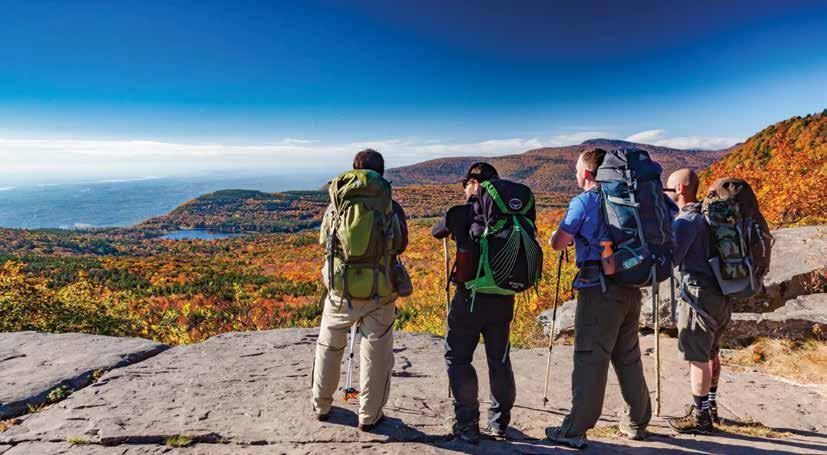
Great Hikes Along the Byway

By Jeff Senterman and Moe Lemire
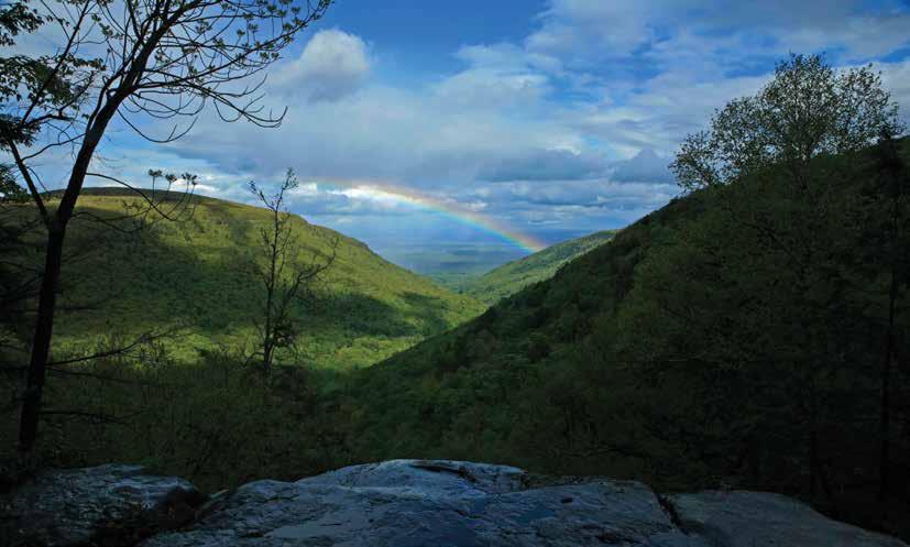
The Mountain Cloves Scenic Byway might be one of most scenic drives in New York State, but there is so much more to explore and see on the trails that traverse the Catskill Mountains surrounding the Byway. There are dozens of hikes possible from the trailheads along the Byway, but here are some of the very best for all types of hikers and explorers!
As you head out on your adventures, don’t forget the Seven Principles of Leave No Trace. These principles can help everyone ensure that the places they visit stay clean, pristine, and remain enjoyable for all to visit.
• Plan Ahead and Prepare
• Travel on Durable Surfaces (like a trail)
• Dispose of Waste Properly
• Leave What You Find
• Minimize Campfire Impacts
• Respect Wildlife
• Be Considerate of Others
As part of planning and preparing, there are some basics for everyone to ensure that they have the best outdoor adventure possible. You should always wear good hiking footwear and clothing appropriate for the weather and carry a backpack that has plenty of food and water in it (always pack extra), a map (we recommend the New York-New Jersey Trail Conference’s Catskill Trails map set), a basic first aid kit, a headlamp, and a multi-tool. We also suggest suntan lotion and bug spray depending on the conditions and time of year.
Family Friendly Hikes
Hunter Branch Rail Trail: The Hunter Branch Rail Trail (HBRT) is a recently completed segment of the Hunter Regional Trail (HRT), a network of rail-trails that run along a former railroad corridor. From Stony Clove Road off Route 214, this easy 1.5 mile in and out trailruns northwest for about a mile along a segment of the Hunter Branch of the Stony Clove and Catskill Mountain Railroad, which was discontinued in 1939. The trail continues on Ski Bowl Road (Country Road 83) for about half-amile to Dolan’s Lake in the Village of Hunter.
Kaaterskill Falls via the Kaaterskill Rail Trail: The 3.5 miles out and back on the Kaaterskill Rail Trail to Kaaterskill Falls offers visitors an easy, almost flat walk from the campus of the Mountain Top Historical Society to the viewing platform at the top of Kaaterskill Falls. On weekends, the Mountain Top Historical Society’s visitor center is open to learn more about the history of the area, including the restored Haines Falls Train Station for the former Ulster and Delaware Railroad, which the rail trail follows. More information available at catskillsvisitorcenter.org/trail/ kaaterskill-rail-trail.
Huckleberry Rail Trail: The Huckleberry Rail Trail runs for 2.7 miles between Clum Hill Road in the east and Bloomer Road in the west. The trail also follows the former Ulster and Delaware Railroad and offers an almost level walk for visitors of all abilities. The trail passes by Lake Rip Van Winkle and follows Gooseberry Creek.
Plattekill Falls and the Platte Clove Nature Trail: Located at the top of the rugged and scenic Platte Clove, Plattekill Falls and the Platte Clove Nature Trail offers a little over a mile and a half Catskill Center’s Platte Clove Preserve, with parking available at the trailhead parking lot located on Steenberg Road, about 100 yards east of the Preserve. From the trailhead by the kiosk, there are two options, the one-mile-long Nature Trail, and the 0.6-milelong Waterfall Trail. The Nature Trail descends to the right, crossing Plattekill Creek on a replica kingpost bridge and then heads straight while the Overlook Trail turns sharp right. From there it loops through the forest at the head of Platte Clove. The Waterfall Trail turns to the left at the trailhead and descends quickly over a third of a mile to the base of Plattekill Falls. More information available at catskillcenter.org/platte-clove-preserve.
Moderate Hikes
Huckleberry Point
Dibble’s Quarry: Dibble’s Quarry is located on the Pecoy Notch Trail, which begins from the trailhead on Roaring Kill Road. The 1.5 mile long, in and out hike is along uneven terrain that can be muddy during wet times of the year. Hikers are rewarded with a scenic view of the surrounding mountains and rock thrones that have been made from the quarry rocks.
Escarpment Trail to Inspiration Point from Scutt Road: The Escarpment Trail is one of the most scenic trails of the Catskills and this smaller section of the larger, 24-mile long trail, offers a taste of the amazing views and adventures you’ll find all along this trail. From the trailhead on Scutt Road, you’ll hike 1.2 miles to Layman’s Monument to your first view of Kaaterskill Clove. From there you’ll reach the stunning Sunset Rock at 1.6 miles and at 1.8 miles you’ll come to Inspiration Point, which doesn’t exaggerate in its naming. From there you can head back the way you came or hike another 0.8 miles along the Escarpment Trail to the intersection with the Sleepy Hollow Horse Trail and follow that back 1 mile to the Escarpment Trail and follow the Escarpment Trail back to the trailhead for a total of 4.7 miles. Note that a map is key in this area as there are many trails and many trail intersections and without a map, it can be very easy to get turned around and disoriented.
Huckleberry Point: This moderate, 4.8 mile hike takes you to the aptly named Huckleberry Point high above Platte Clove and offers an expansive and panoramic view of the edge of the Catskill Mountains and the Hudson Valley beyond. The trail begins at the trailhead and parking area on Steenberg Road. Follow the Long Path for 1 mile to the intersection with the Huckleberry Point Trail and turn left on the Huckleberry Point Trail. The 1.4 miles to Huckleberry Point climb and descend moderately and there are a few muddy areas during wet condi- tions along the way. The trail ends at Huckleberry Point. Return the way that you came.
Difficult and Strenuous Hikes
Orchard Point: Located high on Plateau Mountain, Orchard Point offers a stunning view southward down the Stony Clove Creek valley and the surround mountain peaks. The trail ascends very steeply 1.3 miles from the trailhead and parking area located on Route 214 in Stony Clove Notch (day use fee required in the summer). Hikers making the difficult climb up are rewarded with panoramic views from the large, open rock ledge that makes up Orchard Point. Return to your vehicle the same way you ascended for a 2.6-mile roundtrip hike.
Hunter Mountain: At 4,020 feet in elevation, Hunter Mountain is the second highest peak in the Catskills. There are several different ways to climb Hunter, but the most direct is via the Becker Hollow Trail that begins at the Becker Hollow trailhead and parking area on Route 214. The trail ascends gently at first, but then quickly becomes very steep as it approaches the summit of Hunter Mountain. At the summit of Hunter Mountain, you can climb the Fire Tower and enjoy its 360-degree views. In the summer months, volunteers from the Catskill Center’s Catskill Fire Tower Project staff the tower and the cabin on the ground –meeting and greeting visitors, answering questions, and offering information. Return the way that you came for a total of 5 miles.
Note that Hunter Mountain is a location where a map is key, as there are many trails and many trail intersections and without a map, it can be very easy to get turned around and disoriented.
Indian Head Mountain: One of the best loop hikes in the entire Catskills, this difficult 6-mile loop hike offers multiple vistas as you climb and then descend one of the high peaks of the Catskills. The trail begins at the trailhead and parking area on Prediger Road. From there follow the Devil’s Path to the east, across the base of Indian Head Mountain. The trail then climbs steeply up Indian Head Mountain to the first of several vistas. Along the way the trail passes more vistas and climbs through narrow rock chutes to reach the summit. You then descend steeply to Jimmy Dolan Notch and continue down the Jimmy Dolan Notch Trail back to the trailhead where you started.
Jeff Senterman is the Executive Director of the Catskill Center for Conservation and Development in Arkville, NY and a member of the Board of Directors for the Catskill Watershed Corporation and the Central Catskills Chamber of Commerce. Moe Lemire is the owner and lead guide of Hike On Guides and is the Leave No Trace Foundation’s New York State Volunteer Advocate. Together Moe and Jeff are the Hiker Trash Husbands and they work together to provide positive LGBTQ+ representation in the hiking world. They love showcasing their own hiking adventures, along with other queer outdoors folks. You can learn more at hikertrashhusbands.com.