8 minute read
Westward Ho Across the Catskills


By T.M. Bradshaw
Travel and commercial shipping via the Hudson River utilized sloops and then, in the early 1800s, steamboats. In late Colonial times, the Susquehanna River, flowing from Otsego Lake in Cooperstown to Chesapeake Bay near Baltimore, was an important transportation corridor. But the Catskills, between these two north-south water highways, were a vast, nearly impenetrable wilderness. A narrow clearing through the forest, a “tote road,” or perhaps more accurately a series of tote roads, connected the two rivers before the Revolution. This early road followed the routes of Native American trails, and walking or riding a horse along it was how people covered the roughly 90 miles between the two rivers.
The first people to attempt a transit of this road in a wheeled vehicle were the family of Joshua Whitney, described by Francis Whiting Halsey in The Old New York Frontier (Charles Scribner’s Sons, 1901) as founder of Whitney Point, a statement in disagreement with the “History of Whitney Point” page at whitneypoint. org, which notes the founding settlers there as General John Paterson and his family. “Paterson’s Point” was later renamed Whitney Point, likely what gave rise to the error. A 1938 Delaware Express article states that that wagon belonged to General Joshua Whitney, which is unlikely—the person who would become General Whitney was 14 at the time of the trip; however, his father was also named Joshua Whitney. During that 1787 journey, Mr. Whitney kept a record of settlements they passed along the way— a total of perhaps three or four dozen families, a total that would grow quickly along with the road.
In the 1790s, this road was somewhat improved. Two journeys over the road in 1792, noted in Halsey’s The Old New York Frontier, were of similar duration. In one, a family relocating west took eight days to drive their cattle and sheep from Catskill to where the Ouleout Creek connects to the Susquehanna, and Solo- mon Martin made a fifteen-day roundtrip between Wattle’s Ferry (formerly across the river from Unadilla) and Catskill. In the same year regular weekly mail service utilized the twenty-five-foot wide road. parture from Catskill meant a Friday night arrival in Unadilla and passengers departing from Unadilla on Sunday arrived in Catskill on Tuesday. Over the first 20 years of the Susquehanna Turnpike, an estimated 300,000 people traveled on it, settling along its length or using it for commerce or continuing on westward. The road was extended west several times, to Ithaca in 1806, to Bath in 1808, and eventually into Pennsylvania on sections usually referred to by other names.
As settlers continued to arrive, they needed better ways to bring in supplies and get what they produced to market. Demand for roads and bridges could not be financed solely by taxation. Early road improvements were at least partially funded by state lotteries; then charters were granted to private turnpike companies to meet the need. These charters required the corporations to build and maintain the roads, allowed them to choose the route, and authorized them to collect tolls. Landowners who had the capital to invest did so for two reasons: dividends and an expected increase in the value of their properties. Five turnpikes joined the Hudson River communities of Catskill, Kingston and Newburgh with the Delaware and Susquehanna rivers; the first of these five was the Susquehanna Turnpike, which followed, with some deviation, that earlier tote road system. While Susquehanna Turnpike was its official name, it was often referred to as the CatskillSusquehanna Turnpike or just the Catskill Turnpike, especially by those traveling east toward the town of Catskill.
Different sources cite different reasons for the turnpike’s deviations from the original road. Some suggest the deviations were based on a desire for profit, routing the road close to or through the stockholders lands, regardless of the degree of elevation. Others state that some of the lower elevations were the problem, that the heavily forested land, once cleared, was too wet and swampy to support a hard road. In some places the felled trees were used as a base, creating “corduroy” roads. Whatever the reason, the turnpike sometimes went straight up a mountain and then straight down the other side instead of following an easier grade.
Six hundred shares in the Susquehanna Turnpike Company were available at $20 each. The list of shareholders included John Livingston, Caleb Benton, John Kortright, Sluman Wattles, and Solomon Martin. The turnpike was in operation by 1802, four years before the Great Western Turnpike that connected Albany with Buffalo, now State Route 20. An 1813 publication, A Gazetteer of the State of New-York by Horatio Gates Spafford, (H. C. Southwick, Albany) referred to the Susquehanna Turnpike as the “Appian Way,” a comparison to the first of ancient Rome’s great highways, a portion of which still exists as a park.
The stagecoach trips were dusty, bone-jarring experiences with rapid descents down mountains, the occasional necessity in wet or snowy weather to get out and help push, and sudden stops resulting from coming up behind drovers moving large herds of cattle or sheep or pigs or flocks of turkeys to market.
Once there were tolls, there were “shunpikes,” people who would attempt to leave the road in advance of a tollgate and rejoin it after the gate. If caught, they could be charged a triple toll and court costs. Traffic by shunpikers wore new looping paths into the landscape at intervals around the toll houses. Sometimes the toll houses were relocated from their original locations to make shunpiking more difficult.
Ten toll gates were set up along the route, which went through Cairo, Durham, Manorkill, Gilboa, Stamford, West Harpersfteld, Kortright, West Kortright, Meredith, Franklin, and ending in Unadilla. Twenty sheep or hogs cost eight cents; twenty horses or cattle, twenty cents; a horse and rider, five cents; a horse and chaise (a two-wheeled carriage), twelve and a half cents; a stage or wagon, twelve and a half cents; a coach or chariot (a four-wheeled carriage), twenty-five cents; a sleigh drawn by two horses or oxen, six cents. In 1807, the General Turnpike Act gave lowered rates for wagons with wheels that were six inches wide and no toll at all for those with twelve-inch wheels because wider wheels caused less road damage.
Some exemptions from tolls existed from the beginning. The turnpike’s charter exempted anyone “passing to or from public worship, or to or from his common business on his farm, or to or from any mill, to which he may resort for the grinding of grain for his family use, or persons going to, or returning from a funeral.” The 1807 General Turnpike Act added persons traveling to a doctor or midwife, going to the polls on election day, going to court, to a blacksmith, and people living within a mile of the tollgate.
In 1804, Caleb Benton of Catskill was president of the corporation and in 1805 a monopoly on running a stage on the turnpike was granted to a small group of men—David Bostwick, Lemuel Hotchkiss, Terence Donnelly, and Stephen Benton, Caleb’s brother. Two stages were to be kept traveling back and forth on the road, with a fare of five cents a mile. Eighty-six milestones adorned the route, enabling the calculation of fares as well as informing travelers of their progress. A Wednesday morning de-

Even though the turnpike shortened the trip considerably, it was still a multi-day journey, so there was a need for inns to provide food and lodging for travelers, and enough travelers to make it a worthwhile enterprise. At approximately the midpoint of the route, Stamford was a natural stopping place. In the 1790s, before the turnpike, Lemuel Lamb built a small tavern in the spot where the Delaware Inn now stands. It evolved into a regular stagecoach stop. In 1813, a new owner, Thomas Montgomery, renamed it the Delaware House.
Timothy Dwight, president of Yale, made a journey along the Susquehanna Turnpike in 1804. He kept a journal of his impressions of the trip, including that many of the inns along the way, which were numerous, were not really inns—they didn’t offer food or lodging—but were “mere dram shops; of no other use than to deceive, disappoint, and vex travellers, and to spread little circles of drunkenness throughout the state.”
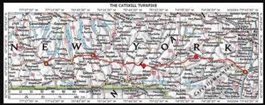
The Susquehanna Turnpike created many benefits for New York and for the young country. But other efforts soon supplanted its usefulness. In 1825, the Erie Canal opened, offering an easier, faster, cheaper way of traveling west. Then, track was laid and railroads provided cheaper transport over an expanded area not limited by waterways. Turnpike tolls were slashed in response, leading to the road falling into disrepair. It officially lasted until 1901, but portions of it had been turned over to state control much earlier—by 1856 everything west of Durham had become a public road. A map and driving directions are included in Dorothy Kubik’s West Through the Catskills: The Story of the Susquehanna Turnpike for those who might wish to spend a leisurely day exploring its length.
T. M. Bradshaw shares other thoughts on history at tmbradshawbooks.com.