Equitable distribution of open space: Using spatial analysis to evaluate urban spaces in context of Udaipur, Rajasthan
guided by Ar. Jaideep Vyas
Bachelor of Architecture
Buddha Group of Institutions, Udaipur
December, 2018

2
Chandni Tandon
This dissertation sets out to investigate the key spatial properties that make for successful urban public spaces; specifically, which affect the patterns of static distribution of these open spaces.
The aim of this study is to develop an analysis of the Equitable Distribution of Urban Spaces along with the edge of historic core which is a unique and rich content of architecture. The idea is to draw attention towards the past patterns and planning’s keeping in mind the climatic, social and topographical context of the city. So that one can learn from them and help in influencing future developments. The objective is also to understand the functioning and need of the urban spaces that have been existing and will help highlighting the key components of architecture for the people of the city, which is used by them and to preserve them for future generations.
5 A b s t r a c t
7
Contents Equitable distribution of open space: Using spatial analysis to evaluate urban spaces in context of Udaipur, Rajasthan...........................................................................................1 Equitable distribution of open space: Using spatial analysis to evaluate urban spaces in context of Udaipur, Rajasthan 2 U n d e r t a k i n g 3 C e r t i f i c a t e.......................................................................................................................4 A b s t r a c t .............................................................................................................................5 A c k n o w l e d g m e n t ......................................................................................................6 Chapter 1: Prelude 11 Introduction to Urban Spaces..........................................................................................12 Aim.......................................................................................................................................13 Objective ............................................................................................................................13 What is the need of these Spaces? 14 Importance of Urban Spaces 14 Background of Udaipur City.............................................................................................17 Udaipur as a Tourist Destination.......................................................................................19 Geography of Udaipur 21 Chapter 3: Interlude: Case studies .....................................................................................23 Leisure/ Recreational ........................................................................................................24 Live Case Studies: ..............................................................................................................26 City Parks; Gulab Bagh Park 26 Water Fronts; Fateh Sagar Lake, Pichola Lake & Gangaur Ghat 30 Fatehsagar Lake.............................................................................................................31 Lake Pichola .......................................................................................................................37 Gangaur Ghat 40 Religious Places; Mahakaleshwar Temple 41 Mahakaleshwar Temple................................................................................................42 Memorials; Ahar Cenotaphs ............................................................................................44 Ahar Cenotaphs 47 City Squares; Sukhadia Circle 49 Sukhadia Circle ..................................................................................................................50 Commercial Place; Old City Market...............................................................................53 The Walled city Market from Samor Bagh to City Palace Complex 54
Table of
8 Chapter 4: Comparative analysis 59 Introduction 60 Opportunities & Strengths.................................................................................................62 Weaknesses & Threats .......................................................................................................63 Chapter 5: Conclude 65 Objective 66 Chapter Organization.......................................................................................................66 Recommendations & Findings.........................................................................................67 Bibliography 69
List of Figures
9
Figure 1: view of the town of Udaipur.....................................................................18 Figure 2: city palace Udaipur...................................................................................19 Figure 3: TOURIST CHART FOR YEAR 2017................................................................20 Figure 4: geology data of Udaipur..........................................................................22 Figure 5: open space framework ............................................................................25 Figure 6: outdoor activities 26 Figure 7: Location map of Gulab Bagh Park.........................................................27 Figure 8: Plan of gulab bagh....................................................................................28 Figure 9: entrance gate of gulab bagh.................................................................29 Figure 10: saraswati library of Gulab bagh ............................................................30 Figure 11: kankaria lakefront project ......................................................................31 Figure 12:Location map of fateh sagar..................................................................32 Figure 13: plan showing Fateh sagar water front 33 Figure 14: plan view of pal side 34 Figure 15: existing Bombay market .........................................................................35 Figure 16: existing plan showing fateh sagar pal..................................................35 Figure 17: sitting spaces at pal side of fateh sagar lake......................................36 Figure 18: location map of lake pichola ................................................................37 Figure 19: lake pichola ..............................................................................................38 Figure 20: jag mandir.................................................................................................39 Figure 21: gangaur ghat view in the evening 40 Figure 22: plan of GANGAUR GHAT stretch i .........................................................40 Figure 23: elevation of stretch i................................................................................41 Figure 24: section at gg’ ...........................................................................................41 Figure 25: location map of mahakaleshwar temple............................................42 Figure 26: schematic plan of mahakaleshwar temple ........................................43 Figure 27: view of mahakaleshwar temple............................................................43 Figure 28: top view of mahakaleshwar temple site 44 Figure 29: Greek Holocaust Survivors memorial ....................................................45 Figure 30: -Washington corridor memorial as a public park ...............................46 Figure 31: location map of ahar cenotaphs .........................................................47 Figure 32: schematic plan of ahar cenotaphs......................................................48 Figure 33: chhatris as kings cemetery.....................................................................49 Figure 34: Old Town Square, Prague, Czech Republic ........................................50 Figure 35: top view of sukhadia circle 51 Figure 36: section of sukhadia circle 52 Figure 37: view of sukhadia circle ...........................................................................52 Figure 38: old city leather market............................................................................53 Figure 39: map showing the stretch covered in walled city for commercial space...........................................................................................................................54 Figure 40: map showing the typologies of commercial spaces in walled city 55 Figure 41: sectional elevation of the market stretch covered 55
10
42:
circulation pattern............................................56
43: city palace shops 57
44:
different
city palace stretch................................................................................................58
45: Udaipur
2031.........................................................63
Figure
map showing existing
Figure
Figure
self-analysis map for showing existing
shops in samor bagh to
Figure
land use plan up-to
Chapter 1: Prelude
11
Introduction to Urban Spaces
In the pattern of land use planning, urban open space is open space or areas for "parks," "green spaces". Generally considered open to the public, urban open spaces are sometimes privately owned, such as higher education campuses, neighbourhood/library/sports field/exhibition halls or galleries/community parks/gardens, and institutional or corporate grounds. Areas which are outside city boundaries, such as state and national parks as well as open space in the countryside, are not considered urban open space. Not only plazas, street’s, or city squares are considered as urban space.
One of the definitions holds that, "As the part of development, urban open space is a natural and cultural resource, like 'unused land' nor 'park and recreation areas." Also, "Open space is land or water area with its surface open to the sky, which is consciously acquired or publicly regulated to serve conservation and urban shaping function in addition to providing recreational opportunities."
However, there are many examples of urban green space which are not publicly owned/regulated, are still considered as urban open space. From another point of view public space in general is defined as the meeting or gathering places that exist outside the home and workplace that are generally accessible by local members and residents living in proximity to the space. The advantages that urban open space provides to citizens can be broken into three basic forms or values; recreation, ecology, and aesthetic value. Here the urban open space is under strong pressure. Due to increasing urbanization, combined with a spatial planning of densification, more people are facing the prospect of living in less green residential environments, especially people from low economic strata.
This may cause environmental inequality with regard to the distribution of public green space. Urban open spaces in higher socioeconomic neighbourhoods were also more likely to have trees that provided shade, a water feature e.g. pond or a lake, walking and cycling paths, lighting, signage regarding dog access and signage restricting other activities as well.
A study conducted in Australia provided insight into how there is a correlation between community development/community safety and natural open space within the community.1
1
https://www.google.com/search?ei=TMEQXNKPKozgvgTbrZrYDg&q=%22A+study+co nducted+in+Australia+provided+insight+into+how+there+is+a+correlation+between +community+development%2Fcommunity+safety+and+natural+open+space+within
12
Open areas allow community members to engage in highly social activities and facilitate the expansion of social networks and friendship development.
Aim
This dissertation highlights the lessons, and considers how changing attitudes towards social, economic and bio-environmental concerns may be considered in design of new public spaces. It is generally speaking a spreadout suburban landscape continuously growing according to what has been called sprawl-like development, increasing energy and automobile dependency, challenging urban sustainability.
In recent times urban growth has also turned inwards because of economic and political change. Thus, one of the main challenges for future urban design will be to ‘compact sprawl’. This theory, set in the field of urban morphology, explores the spatial conditions for suburban densification by looking at administrative and user-related measures of density, public open space, and pedestrian accessibility. If we even consider useful open space, it would not decrease density, but would rather increase spatial compactness.
Objective
The level and frequency of social activities, activities that rely upon interaction between people, increase with increasing quality of the setting. Since social activities are the result of people spending more time out of doors and having more opportunity to interact, the frequency of interaction jumps dramatically with improvement in setting. This dissertation, when considering the objective as the perception of the quality of a public space, is instructive in understanding the types of activities that take place in Udaipur City and between which groups of people. Core in this understanding of space is especially a turning point in a discussion of space and its production. These reflect the spaces each of us perceive as we live our daily lives.
It is likely concluded from study that we will be more dependent on walking, bicycling, and public transportation in the future.
Street networks and public open spaces are then key issues today, creating compact, sustainable, liveable, equitable, and more competitive cities.
+the+community.%22&oq=%22A+study+conducted+in+Australia+provided+insight+i nto+how+there+is+a+correlation+between+community+development%2Fcommunit y+safety+and+natural+open+space+within+the+community.%22&gs_l=psyab.12..0i71l8.0.0..409669...0.0..0.0.0.......0......gws-wiz.i5c0tUsbgmE
13
In fact, many compact urban cores such as in Stockholm, London, and Manhattan have through the 20th century persistently stood up to the competition against more sprawling cities.2
The report shows that compacting inner suburbia seems to be the new frontier many cities and planners are facing. In fact, this is a vast unexplored field that needs further attention in urban studies and urban morphology in particular.
What is the need of these Spaces?
Public spaces are not a “nice to have” or just an aesthetic view but a basic need for cities. We often think of amenities such as public parks, quality commercial streets, city squares, waterfronts, public buildings like library, museums, and other well-designed public spaces as luxury amenities for various communities. On the other hand, research increasingly suggests that they are even more critical to well-being of the poor and the development of their communities, who often do not have spacious homes and gardens to retreat to. It has been analysed that living in a confined room without adequate space and sunlight increases the likelihood of health problems. Public spaces serve to extend small living spaces and providing areas for social interaction and economic activities, which improves the development and desirability of a community.
However, it increases productivity and attracts human capital while providing an improved quality of life. Public spaces therefore should be considered as a basic service, with the same priority as transport, water and sanitation which communities often primarily focus their resources on.
Importance of Urban Spaces
Despite the importance of such spaces, public spaces are often poorly integrated or neglected in planning and urban development. However, more and more research has suggested that investing in them can create prosperous, liveable, and equitable cities in developing countries. Public spaces act as an important asset to our cities. They provide with many opportunities to come together and engage with the community.
If open public spaces are successful, it means they are inclusive of the diversity of groups present in our cities and create a social space for everyone in the society to participate in. Also, in Urban planning and the importance of green space in cities to human and environmental health.
Cities are not just the buildings and its people. The most “liveable” cities – and some of the world’s most famous cities – are as known for their open space as they are for their culture.
2 http://swepub.kb.se/bib/swepub:oai:DiVA.org:kth-9193?tab2=abs&language=en
14
A new, broad aspect of parks has also recently been emerging. As the world’s cities continue to grow, parallelly continuing to value green space in cities is vital: but is also a challenge, particularly in developing nations where there is pressure for space, resources and development.
There are several such health benefits associated with access to public open space and parks. Access to parks, library, open spaces, and playgrounds has been associated with better perceived general health, reduced stress levels, reduced depression and more.
According to the World Health Organization, physical inactivity is a major public health risk. In Australia, nearly half of all Australians do not meet even the 30 minute daily physical activity recommendations. One study found that people who use public open spaces are three times more likely to achieve recommended levels of physical activity than those who do not use the spaces. Thus, by improving the access to public space has shown the potential to increase levels of physical activity, and to have mental health benefits and reduce healthcare and other costs 3
A network which includes of protected natural lands, ecological reserves, wetlands, and other green areas is critical to providing healthy habitats for humans, wildlife and plants in these densely built places. Therefore, natural landscapes are playing a vital role into preserving regional ecosystems in overall growing of cities It is thus proved that how Parks help create human and energy efficient cities that can help slow global warming. Brazil, home to more than 56,000 plant species, has taken the lead in setting new trends in urban planning. Its “green city” Curitiba has demonstrated that urban planning can be environmentally friendly. Curitiba’s population of 1.8 million consumes 23 per cent less fuel per capita than the Brazilian national average. This city occupies 16 parks, 14 forests, and over 1,000 green public areas shared by its residents. 4
It’s not just cutting the grass and picking up the garbage. Here is the time when we need to think of parks more as outdoor community centres where we need to invest in uses and activities so they can fulfil their potential.
As truly said; When we improve parks, we’re really improving quality of life.”
3 http://www.hphpcentral.com/article/urban-planning-and-the-importance-ofgreen-space-in-cities-to-human-and-environmental-health 4
https://www.google.com/search?q=%22Its%20%E2%80%9Cgreen%20city%E2%80%9D %20Curitiba%20has%20demonstrated%20that%20urban%20planning%20can%20be% 20environmentally%20friendly.%22
15
Chapter 2:
Urban space in context of Udaipur
16
Background of Udaipur City
The royal city of Udaipur being the capital of Mewar for several centuries. The city has a legend behind its establishment. Once during his hunting expedition, Maharana Udai Singh met a holy sage in the Aravalli ranges. The sage directed the king to create a kingdom in this fertile valley, which would be protected by the high-rising Aravalli’s. Consequently, Maharana Udai Sing established Udaipur in 1553 AD.
Chittorgarh was the former capital of Mewar Kingdom and Maharana Udai Singh was the successor of the Sisodia clan, as say the descendants of the Sun God, who believed themselves to be the world’s oldest ruling family. The kings and the members of this dynasty were known to be the most powerful warrior clan in Rajasthan. Therefore, the capital was also moved to Udaipur from Chittorgarh, because of constant enemy attacks.
(https://www.google.co.in/search?q=1553++udaipur&rlz=1C1CHBF_enIN786I
N786&source=lnms&tbm=isch&sa=X&ved=0ahUKEwi_m8zl9ZffAhUEXisKHfUFA9
4Q_AUIDygC&biw=1536&bih=763#imgdii=B_BpXJb28UUIHM:&imgrc=Sblr2chE
17
FIGURE 1: VIEW OF THE TOWN OF UDAIPUR

The Mughal Emperor attacked Chittor in the year 1568, and to keep away from his clutches, Udai Singh shifted his kingdom to Udaipur, which was a safer place. It was since that time that Udaipur got transformation modern city.
Overlooking the aquamarine expanses of the Lake Pichhola stands the splendid City Palace - a marvel in granite and marble. Out of the original eleven gates of the Udaipur City, only five still remain. For the safety of the new capital the king built a wall with the length of 6 km with its main gates in it namely – Brahmpole, Ambapole, Hathipole, Udiapole, Chandpole, Surajpole. The area that resides in the wall is now commonly referred as ‘The Old City’ or ‘The Walled City’. The British didn’t show their much interest in acquiring Udaipur because it was a mountainous region which made it difficult for their army to carry heavy armoured horses and weapons. On the eastern side of the city, the periphery has a Surajpole or Sun Gate which is the main on entrance to the city. Udaipur being the city of dawn, and a lovely land around the azure water lakes, hemmed in by the lush hills of the Aravalli hills. Udaipur is fascinating mixture of sights, sounds and experiences Its kaleidoscope of fairytale palaces, lakes, temples, gardens and narrow lanes strewn with stalls, carry the flavour of heroic past, epitomizing valour and chivalry.
18 YaaKgM:, n.d.)
Udaipur as a Tourist Destination

Udaipur is one of the most popular cities in Rajasthan, and is quite famous for its lakes and palaces. Also, known as the ‘Jewel of Mewar’, in 1553 this city was founded by Maharaja Udai Signh, on the banks of Lake Pichola. Udaipur is claimed as one most romantic city of world and mini Venice. (https://www.google.co.in/imgres?imgurl=https%3A%2F%2Ftravelblog.waytoindia.com%2Fwp-
content%2Fuploads%2FJag_Mandir.jpg&imgrefurl=https%3A%2F%2Ftravelblog.waytoindia.com%2Fplaces-to-visit-inudaipur%2F&docid=BuEsuift1VbZ4M&tbnid=I6TYuhFbDsrljM%3A&vet=10a, n.d.)
FIGURE 2: CITY PALACE UDAIPUR
Udaipur today, it is a perfect mixture of old-world charm and contemporary attractions. Every year, in abundance tourists visit the ‘City of Lakes’ Udaipur, by getting enchanted from its vibrant culture and traditional customs. It is still inhabited by the local people of Bhil tribe, so we can still see people dressed in traditional Ghagra-Choli, laden with huge silver jewellery. People of all different religion- Hinduism, Islam, Sikhism and Christianity reside here. The modern city of Udaipur is a vivid hub of social- cultural activities, art, music and folk dance. While living in Udaipur one can see both kinds of people- those following their age-old traditions and also those who have adopted a modern style of living. The city plays as a host to a number of fairs and festivals of the country. Udaipur Stands Second in The Number of Foreign Tourists in Rajasthan.
19
As compared to 2016 annual chart of tourist ratio in city, there was an increase of 10 percent in data of foreign tourists. As per the tourism department, tourists from French and America have increased in numbers in 2017. Whereas in Rajasthan, tourists from French outnumbered all other tourists in 2017. On number three we have American tourists in the increasing list of tourists. Consequently, in this 7th year, it is growth for Udaipur that foreign tourist numbers were seen going high.
Udaipur stands at number second in the year 2017 after Jaipur which stands with the highest number of foreign tourists. Jaipur with a number of 9,50,991 foreign tourists whereas Udaipur had 3,47,542 foreign tourists. Jodhpur stood 3rd with 1,69,264 foreign tourists.
(https://udaipurtimes.com/udaipur-stands-second-in-number-foreigntourists/)

20
FIGURE 3: TOURIST CHART FOR YEAR 2017
Overview of Methodology adopted for the research with a blend of secondary as well as primary research. The detailed task wise methodology, target groups and information procured from each source is given below(http://tourism.gov.in/sites/default/files/Other/rajisthan.pdf)
Geography of Udaipur

21
Chapter 3: Interlude: Case studies
23
Leisure/ Recreational
Recreation is an activity of leisure, leisure being conducted at discretionary time. The "need or a break to do something for recreation" is an essential element of human biology and psychology for relaxation and stress-free living Recreational activities are often done for a break, enjoyment, to work out emotional stress mood, amusement, or pleasure and are considered to be "fun".
• Leisure Lowers Stress and Depression. Mental wellness is an important part of your overall health and can impact your physical well-being. Participating in different leisure and recreation activities can help us better manage stress and reduce depression.
Passive recreation, also called as "low intensity recreation" is that which emphasizes on the open-space aspect of a park and allows for the preservation of natural habitat.
Such kind of recreational activities usually involves a low level of development, such as rustic picnic areas, benches and trails. Passive recreation requires little management and can be provided at very low costs and ease to people in need.
24
F
IGURE 6: OUTDOOR ACTIVITIES
Live Case Studies: City Parks; Gulab Bagh Park
Gulab Bagh, also known as Sajjan Niwas Garden, was built by Maharana Sajjan Singh in the 1858. The garden has innumerable varieties of roses. Gulab Bagh is an old Sub-City Level Park, having lush green campus and several places of

26
attraction including ponds, library, zoological park, temples and several government offices.
It houses 12 Bovri’s, 5 tube wells, 1 large pond (Kamal Talai – under rejuvenation), 1 zoological park, couple of temples – Arya Samaj, Hanuman, Dargah etc. It also has a range of two Government offices like forest office, and two PHED offices, also one PWD office, and one public library etc.
The park has four major entrance gates, which are designed artistically as old masonry structure. It has four gates out of which only two of the gates are open for general public. The parking facility is appropriate and is available at 2 operational entry gates, and it currently accommodate 350 two wheelers and 50 car parking inside the park. The entire periphery of park is surrounded by a boundary wall, which is of 3–5 m in height and is made up of mix of concrete, stone and brick.

27
FIGURE 7: LOCATION MAP OF GULAB BAGH PARK
Gulab Bagh is situated at the centre of the city, spread from the edges of Surajpole and Udaipole area, the main road circling around the entire Gulab Bagh is called as Gulab Bagh Road. In the proximity of Gulab Bagh we have various hotels and other attractions like Vintage Cars and Classic Car Museums. Also, lord Ganesh Temple are situated near this place for visitors. It is situated quite near Pichola Lake on Lake Palace Road Gulab Bagh is a huge 100-acre interesting park in the southeast side of City Palace complex.

28
FIGURE 8: PLAN OF GULAB BAGH
It is easily accessible from the city by local transport, taxis or auto rickshaws. A footfall of 3000 people per day is visited here including local as well as tourist visitors.

29
F
IGURE 9: ENTRANCE GATE OF GULAB BAGH
FIGURE 10: SARASWATI LIBRARY OF GULAB BAGH
Sajjan Niwas Garden or let’s say the Gulab Bagh also has a library known as Saraswati Bhawan Library. King Maharana Fateh Singh built it in 1887 and was opened for public in November 1890. It was once known as Victoria Hall Museum and is currently used as a library for common public. Along with this it was the first ever museum constructed in Rajasthan.

Water Fronts; Fateh Sagar Lake, Pichola Lake & Gangaur Ghat
Water has the magic to attract people and have been favourite location for celebration and ceremony. It can act as a focal point and fundamental attraction in all culture and among all classes of people. Waterfront has the advantages to recreate the image of the city, recapture the economic investment and attract people back to deserted downtowns. Waterfront can also be defined as a piece of land or part of a town which is next to an area of water and borders a body of water. Different water bodies like lake, pond, canal, river, sea and bay are considered as the man-made water element.
(https://www.google.co.in/search?rlz=1C1CHBF_enIN786IN786&biw=1536&bi
h=763&tbm=isch&sa=1&ei=fL4PXJefNJL8rQHEwbCABw&q=lakefront+develop
30
ment+india&oq=lakefront+&gs_l=img.3.0.35i39j0i67j0j0i67j0j0i67j0l2j0i67l2.33869 .33869..36029...0.0..0.128.128.0j1......1.., n.d.)
The urban waterfront can include any urban area that overlooks to an adjacent river, sea, lake, canal or an artificial water body. One of the factors to success for a public domain is the strength and clarity of its pedestrian connections. The waterfront pedestrian promenade is connected back to the streets and public space that provided along the path. Integration of building form with the waterfront and will create a vibrant and safe public space where the landscape forms a green setting for the buildings and provides usable space for the occupants to appreciate.
Fatehsagar Lake
Fateh sagar is a manmade lake built in 1687 by Maharana Jai Singh. But after 200 hundred years the lake formed was washed away due to floods in the earthen bund. However, after that in 1889 Maharana Fateh Singh rebuilt the dam known as ‘Connaught Dam’ at Dewali area, to mark the visit of Duke of Connaught, son of Queen Victoria.
https://www.google.co.in/maps/place/Fateh+Sagar+Lake/@24.6016326,73.6 630766,15z/data=!3m1!4b1!4m5!3m4!1s0x3967e53c8c2ac0e3:0x797deb83de7

31
FIGURE 11: KANKARIA LAKEFRONT PROJECT
Fateh Sagar is an artificial lake which is named after Maharana Fateh Singh of Udaipur and Mewar. It was constructed in north-west side of Udaipur, which is to the north of Lake Pichola in the 1680s. Therefore, it is one of the four lakes of the Udaipur city. Within the circumference covered for the Fatah Sagar Lake, there are three small islands.
• The largest amongst of these is the Nehru Park which is (4 km2 (1.5 sq. mi) area). It is a popular tourist attraction.
• The second island is (0.06 km2 or 15 acres area) houses a public park with an impressive water-jet fountain.
• The third island and the most important out of all is (1.2 km2 area) and is also the address for the Udaipur Solar Observatory (USO).

32
b53b8!8m2!3d24.6013999!4d73.6742232
FIGURE 12:LOCATION MAP OF FATEH SAGAR
FIGURE 13: PLAN SHOWING FATEH SAGAR WATER FRONT

The Nehru Park is accessible only by inboard motor boats. The fascinating blue water of the lake and the backdrop of the green mountains ‘Aravalli’s’ has given the soubriquet of ‘the second Kashmir’ to Udaipur. However, the Udaipur Lake Conservation Society’s reports have indicated that the lake supports and sustains ground water recharge, drinking water, agricultural use, industrial use, ecological water availability and provides employment to 60% population of Udaipur.
(https://www.google.co.in/search?rlz=1C1CHBF_enIN786IN786&tbm=isch&q= fateh+sagar+lake&chips=q:fateh+sagar+lake,g_1:udaipur:t9GGfnaUZ8g%3D &usg=AI4_-
kSOW45O7md7zK9o5qC0WOMuszytiA&sa=X&ved=0ahUKEwiI8qvAl5jfAhURcC
33
sKHQ0FBQgQ4lYIKSgA&biw=1536&bih=763&dpr=1.25#im, n.d.)
The lake is divided in two major parts: Pal & Food Street, both having different parking provisions and accommodating 70-80 two-wheeler and 20-25 fourwheeler approximately. The average footfall here is around 3000-4000 persons per day in five days of week and up to 10,000 people on Saturdays and Sundays.

34
FIGURE 14: PLAN VIEW OF PAL SIDE
At the Fatehsagar Pal, the Chhatris have been used as places from where people can climb up to the elevated walkway and then more seating platforms have been introduced to allow for more people to sit and enjoy the view of the Lake.


35
FIGURE 15: EXISTING BOMBAY MARKET
FIGURE 16: EXISTING PLAN SHOWING FATEH SAGAR PAL
Gangaur Ghat

At the northern end of the lake are the Ghats which is where the annual festival of Gangaur is celebrated with great gusto.
Gangaur Ghat is a prime location of Udaipur that is situated in the heart of the city; streaming through the old veins of the old city area. Gangaur Ghat serves itself for various purposes including the convenience of locals, serenity to tourists and a hanging spot to the young blood of Udaipur.
Gangaur Ghat is considered as one of the main Ghats of Udaipur. It is located on the banks of the Lake Pichola in the old city near Bagore Ki Haveli. It is recommended to take a two-wheeler or walk to access the location, as the roads in the old city are a bit congested and can make fourwheeler create a hassle on the scene.

40
FIGURE 21: GANGAUR GHAT VIEW IN THE EVENING
FIGURE 22: PLAN OF GANGAUR GHAT STRETCH I
FIGURE 23: ELEVATION OF STRETCH I
In 1972, Gangaur Ghat was not covering the area that it covers today. It was defined to Tripoliya Gate only. In 1973, after the sprawl of residents and shops it was extended to further boundary.

Religious Places; Mahakaleshwar Temple
The word 'Religious Place' itself brings a sense of reverence in the mind. A tour doesn't only mean roaming round the substantial worldly structures, but something that has a spiritual appeal too. The Religious Places in and around Udaipur are famous for their striking architecture and religious nature. The

41
FIGURE 24: SECTION AT GG’
religious building foreshadows the cultural aspect of Udaipur. There are numerous such buildings in and around Udaipur that are famous for their architecture and sacredness. The noble kings and rulers of Udaipur had always been great advocates of religion and have always prioritize and kept religion at the uttermost position.
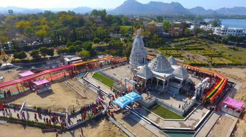
Mahakaleshwar Temple
(https://www.google.co.in/maps?rlz=1C1CHBF_enIN786IN786&q=mahakalesh war+temple+udaipur&um=1&ie=UTF-8&sa=X&ved=0ahUKEwj7z-6oZjfAhUUdysKHTI6AycQ_AUIDygC, n.d.)
Lying on the banks of Lake Fatehsagar, opposite Panna Vilas, the splendid Mahakaleshwar temple has the lofty Aravalli’s in the background.

42
FIGURE 25: LOCATION MAP OF MAHAKALESHWAR TEMPLE
It is believed that Guru Gorakhnath who was a popular saint and a distinguished devotee of Lord Shiva had also worshipped here. The temple covers an area of around 3.5 acres. The temple is visited by devotees of lord shiva.


43
FIGURE 26: SCHEMATIC PLAN OF MAHAKALESHWAR TEMPLE
FIGURE 27: VIEW OF MAHAKALESHWAR TEMPLE
The temple opens early in the morning, first puja takes place at 5.30 A.M. and the last puja (prayer) takes place at 10.30 P.M.
The Rajbhog puja takes place at 11.30 A.M. and the evening Aarti takes place at 6.30 P.M. Which is attended by large number of devotees as they are centre of attraction for the visitors as well as devotees.
It includes:
❖ Nakshatra Garden
❖ Lawns
❖ Offices
It has a footfall of 500-1000 persons per day, and the number increases to 2000-10,000 persons per day in festive season.
Memorials; Ahar Cenotaphs
Memorial architecture, which used to hold intense emotional meaning for certain individuals or groups of people, but this has now gradually become tourist attractions or urban space sites within a changed landscape.
(https://www.google.co.in/search?q=memorials&rlz=1C1CHBF_enIN786IN786
&source=lnms&tbm=isch&sa=X&ved=0ahUKEwjb7sbJopjfAhUGeCsKHVUSCG
MQ_AUIDigB&biw=1536&bih=763#imgdii=-
44
FIGURE 28: TOP VIEW OF MAHAKALESHWAR TEMPLE SITE
Ahar Cenotaphs
(https://www.google.co.in/maps?rlz=1C1CHBF_enIN786IN786&q=ahar+ cenotaphs&um=1&ie=UTF-
8&sa=X&ved=0ahUKEwjxzJi6o5jfAhWKXysKHbTNB98Q_AUIDigB, n.d.)
FIGURE 31: LOCATION MAP OF AHAR CENOTAPHS
The Ahar Cenotaphs being a memorial are a group of cenotaphs located in Ahar, Rajasthan, and situated about 2 km east of Udaipur, in Rajasthan, India.

47
The site constitutes of more than 250 cenotaphs of the maharajas of Mewar that were built over approximately 350 years. In all there are total of 19 chhatris that commemorate the 19 maharajas who were cremated here. It has 5 gates to access the site and 2 main gates for entry and exit.

48
F
IGURE 32: SCHEMATIC PLAN OF AHAR CENOTAPHS
FIGURE 33: CHHATRIS AS KINGS CEMETERY

It consists of 312 Chhatris’. Timings to visit here are from 8 A.M. to 6 P.M. The daily footfall of locals as well as tourists counts 20-30 persons per day and 6070 persons in peak seasons.
City Squares; Sukhadia Circle
A city square is associate degree open public house ordinarily found within the heart of a conventional city used for community gatherings. Also, other names are town square, civic centre. green.(https://www.google.co.in/search?q=city+squares&rlz=1C1CHBF_enIN 786IN786&source=lnms&tbm=isch&sa=X&ved=0ahUKEwjT4-
49
FIGURE 35: TOP VIEW OF SUKHADIA CIRCLE
Sukhadia Circle is a popular recreational centre in Udaipur in Indian state of Rajasthan. Sukhadia Circle was inbuilt in 1968 and opened for public in 1970. It has been named after Late Mohan Lal Sukhadia, the ex-Chief Minister of Rajasthan and a native of Udaipur. It is an outsized roundabout within the city's northern suburb of Panchwati, on the road to Ranakpur and Mt. Abu.

51
n.d.)
MSEg6aTFuoM:&imgrc=X-b3SYKFxz_sFM:,
F
IGURE 36: SECTION OF SUKHADIA CIRCLE

It provides options for fast food centres, camel and horse rides, boat ride and kids play zone areas. Sukhadia Circle is a small pond, at centre of which lies a 21 ft. high three-tiered fountain. The fountain is made of white marble, and is shaped like a wheat-ear motif, which stands as a symbol of prosperity. The pond offers boat ride, and options for camel and horse ride as well around the Sukhadia Circle are also available. It is conjointly encircled by several little gardens and food joints, and kids play-zone areas around it.

FIGURE 37: VIEW OF SUKHADIA CIRCLE
The Sukhadia Circle in Fatehpura area of Udaipur is very significant as it was developed to use the major junction which connect Udaipur to other cities like Nathdwara and Jodhpur. The National as well as State Highway passes from here and an artificial lake as well as Chowpatty (food court) are the
52
Chapter 4: Comparative analysis
59
Introduction
This study is about the phenomenon of urban planning processes. The methodological approach is qualitative research. The data collection relies on live case studies, interviews and a time graph analysis of different places at different peak time. The time graph along with age graph are based on their experience of age or participation in type of activities, involvement in different urban spaces, footfall of different spaces, with the analysis of interest and opposition against the urban project. The theoretical literature and the planning typology are analysed through the theoretical framework of past, present and future scope.
This process resulted in identifying the Opportunities, Threats, Strengths and Weaknesses of each case study conducted. Which in turn resulted in the conclusion that, based on the study’s main findings and recommendations.
Table showing footfall of public at different spaces, different times, and as per age.

As per the live case studies and analysing interests of local as well as tourist public in Udaipur City, I was able to conclude that the tourists especially like to be in the Walled City area and are fonder of exploring the traditional, heritage architecture & culture if the city. Instead, there is a bunch of local residents of Udaipur City who consider accessibility as a priority and then the “View”.
Also, there is another graph to show that annually in the city of Lakes more than 2 lacs people come and go, and all have their own preferences, likings, and comfortability through which they explore the Udaipur City.
60
Table showing annual tourist graph in Udaipur as per their population and preference list. Here, the population is the annual tourist count from respective countries and preferences mean that where they choose to accommodate (i.e., choice of hotels) themselves for a stay in city.
This particular table here exhibits that how being at the maximum population i.e., London and Italy tourists arrive in city, and prefer the Walled City for their accommodation and exploration. Tourist from Australia and Germany will prioritize access first and then view. Here, of course they will be in vicinity to Old city but will not choose a hotel where accessibility is an issue. Moving on to Indian Tourists, which is majorly from Gujarat & Kolkata, they have a different taste from foreign tourists. India, the whole country itself celebrates this traditional architecture and inherits the old ‘Gali’ or let’s say narrow passage concept in almost all Indian States, so for them the Walled City is not that something really WOWS!
So, they find resorts or a hotel at outskirts from Walled city because they don’t want to get into the hustle bustle and crowded streets with jams, animals and shops on both hands. Rather they try to focus on serenity while booking their accommodations.

61
Opportunities & Strengths
Fateh Sagar Lake
Accessibility
Convenient
Parking 25- 30 four wheelers/ 80-100 two wheelers
Peak Timings
5-9 PM
Footfall 4000 per day/ 10,000 on weekends
Amenities (Eatery Stalls) 15-20 Stalls
Gulab Bagh Park
Accessibility Convenient
Parking 45-50 four wheelers/ 320-350 two wheelers
Peak Timings
6-10 AM/ 5-8 PM
Footfall 3000 per day/ 8,000 on weekends
Amenities (Eatery Stalls) No
The above two tables represent an Opportunity and Strength based Analysis of two most prominent and most visited Urban Spaces in Udaipur. Both of them cater a major footfall on a per day base and both have different reasons to accommodate a huge crowd on daily basis. The footfall is totally based on Age Groups and Interest of public.
One being the Park and another being a Waterfront have been the most liked and visited public spot for local as well as foreign public.
Gulab Bagh in the heart of Udaipur city, is a lush green 100-acre space, generating a green layer and pollution free environment.
Fateh Sagar, a beautiful lake approximately 8.2 km in circumference, is the beautiful urban space in city with a space for recreation. Both of them are
62
visited for different purposes and are under Recreational Land Use of master plan of Udaipur City.
Weaknesses & Threats
The weakness and threats are somewhere intertwined and similar to one another. While focussing on Demographics of Udaipur city, I analysed that the land use decided at the foremost, don’t old enough capability for now with current population. If we notice the urban sprawl, one can clearly understand city’s growth pattern.
As the circle, here denotes the demarcation of the distribution of urban space in the demographics of land use map.

Urban open space - both magnitude and spatial arrangement - is critical to urban living. As the availability of open space, distribution and accessibility are a major concern for cities. Open space is a necessity and not a luxury.
Due to ongoing urbanisation trend worldwide, the distance between city inhabitants and nature is increasing. Urban greenery is one of the ways to
63
FIGURE 45: UDAIPUR LAND USE PLAN UP-TO 2031
bridge this gap between people and nature. With the growth of urban sprawl or the migration the increase in density is one of the reasons for underdevelopment of urban greenery sector. Without careful planning, cities will be stressed with environmental challenges. As we have found out in the case studies that the geography of all these urban spaces is more towards western side of Udaipur city, as compared to it as a whole. Open space is a basic type of land use along with residential, commercial, industrial, transportation etc. Other than open space, the rest are given due importance for progress and it is neglected because it caters to natural, recreational and cultural needs that are intangible.
64
Chapter 5: Conclude
65
Objective
In the light of the stated research problem above and the characteristics of growth of Udaipur city, the research objectives of the present study are:
• The idea is to analyse spatial arrangement of open space.
• To identify the factors affecting distribution and magnitude of open space and seek relationships between built environment and open space.
• To evaluate the role of city plan in the provision and maintenance of public, institutional, private and community open space.
• To provide inputs for planning and monitoring of urban open space.
Chapter Organization
1.1The study is presented in five chapters. The first chapter being the Prelude, is Introduction to the concept of urban space, introduction of such open spaces, what is the aim of the study, need and importance of such spaces.
1.2 The second chapter is on Background study of Udaipur study. Also, where Udaipur stands as a Tourist Spot and Geographical analysis of the city.
1.3 The third chapter which is the Interlude studies the Open space in Udaipur by conducting different live case studies of different variety of urban space.
The description of different recreational spots like: Parks, Waterfronts, Religious Places, Memorials, City Square and Commercial Sector.
That how these places replaced in location map, their areas, footfall and amenities.
1.4 The fourth chapter deals with the comparative analysis of these spaces on a broader scale. Discussing the SWOT Analysis by comparison of user profile, on analysis of variations on weekday and weekend and in different time slots of morning, afternoon and evening. The volunteer surveys were done to analyse the variation in the user characteristics. This analysis reflects a need for creation as well as preservation of green areas for recreational and leisure time activities through planned initiatives.
1.5 The fifth chapter deals with the Government initiatives for the provision of open space in the drafted Master Plan and also area wise analysis has been done to see the open space available per person in the different areas of the city.
66
This chapter concludes the study and suggests the improvements that are needed so that people may have comfortable access to open space
Recommendations & Findings
Green areas and alternatives-based solutions supply innovative approaches to extend the standard of urban settings. It enhances local resilience and promote sustainable lifestyles, improving both the health and the well-being of urban residents. Parks, playgrounds or vegetation publicly and personal places are a unit central part of these approaches and may felicitate to make sure that:
• urban residents have adequate opportunities for exposure to nature;
• urban biodiversity is maintained and protected;
• environmental hazards such as air pollution or noise are reduced;
• the impacts of extreme weather events (heatwaves, extreme rainfall or flooding) are mitigated;
• the quality of urban living is enhanced;
• the health and well-being of residents is improved.
Urban inexperienced area could be a part of “green infrastructure”. It is a vital part of public open areas and customary services provided by a town and may function as a health-promoting setting for all members of the urban community. It is thus compulsory to make sure that all urban, open or public green spaces are easily accessible for all age groups and distributed equitably within the city.
Land use planning is central for managing issues related to climatic variation in urban environments. However, Master Plans usually do not include climatic aspects, and few studies have addressed climate change at the urban scale, especially in developing countries.
This report proposes a framework with live case studies helping & concluding the more and more placement of urban space at one part of the city and ignoring the rest of it.
Each category comprises attributes that describe a complex of relationships in influencing amenities for local public as well as the tourists. Proper land use planning provides the opportunity to assess where you are, where you would like to go and how you might get there.
Planning now to protect important open space and recreational facilities can greatly enhance the attractiveness of your community and encourage compatible growth in the future. Also, planning accordingly helps allowing the City to confront and manage aspects of growth and development in
67
ways that preserve, protect, and enhance the environment. The urban planning process in relation with equitable open space relationship can expose potential problems while there is still time to prevent them. Open space plans allow the benefits of open space that make up the character and protects the "green infrastructure" of a community. With the help of planning the spaces wisely this "green infrastructure" of water supply, land, working farms and forests, viable wildlife habitats, parks, recreation areas, trails, and greenways is as important to the economic future of a community as coming up with for planning for schools, roads, water, and wastewater infrastructure.
Although open area itself could be an easy concept, the factors that have effect on it, which affects, are complex. Through an Open Space Plan, one can identify and examine these factors and lay out strategies for residents and can use to protect and enjoy its character, natural resources and open spaces.
Consequently, these findings form a replacement approach to the difficulty of patterns of spatial use of public spaces, based on the global understanding of the dynamics of the urban grid and the visual and the permeability connections between public space and the urban environment.
68

