PORTFOLIO 2021-2022 CHETAN AGGARWAL
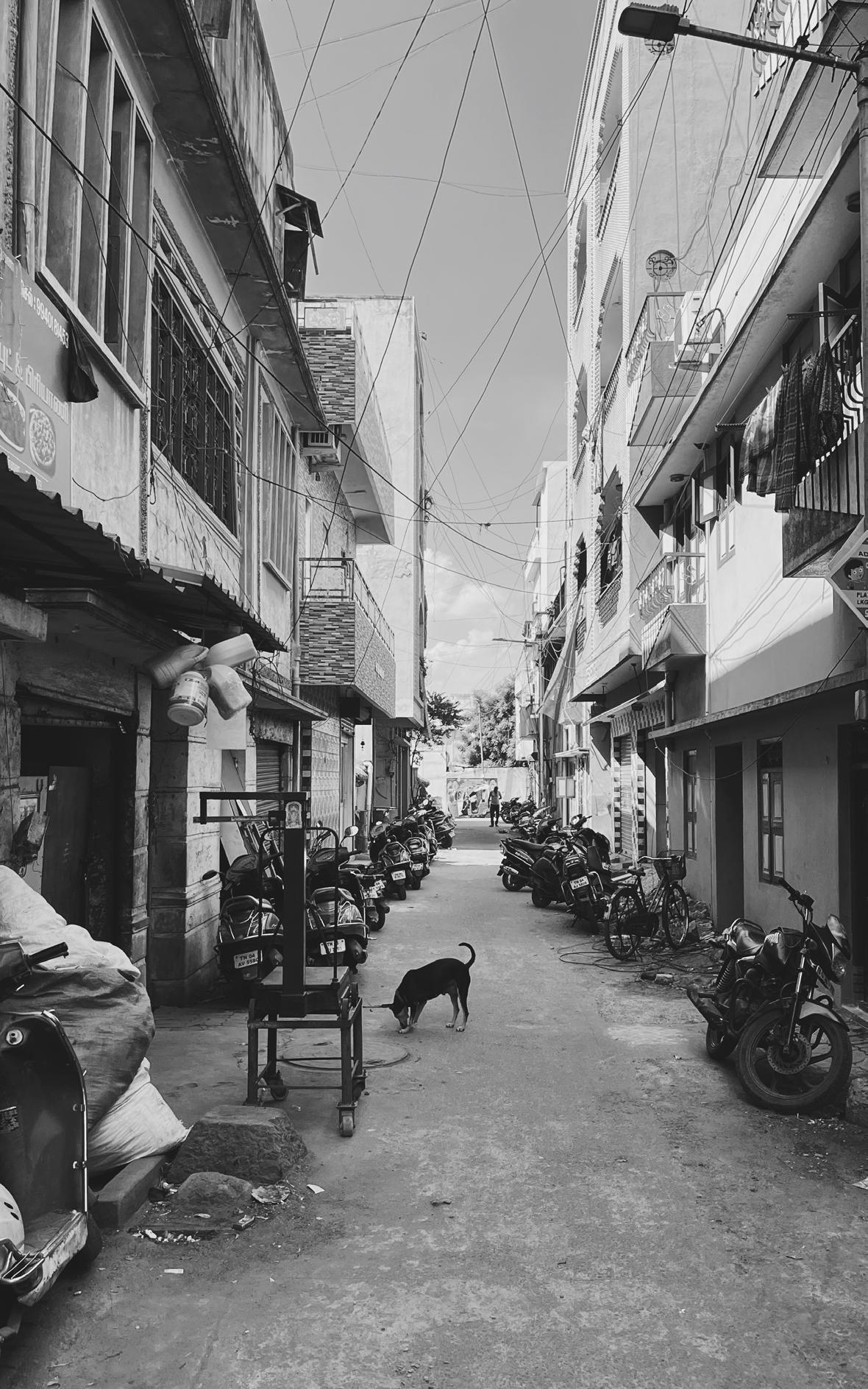
A typical Indian street
Hello! I am Chetan Aggarwal, an architect from Delhi, India. Designing cities for the people captivates me, and I strongly reckon on sustainable, ethical and responsible design as the real engines of harmonious growth for our built environment.

I believe architecture spreads beyond the boundaries of desiging and shaping cities, and in fact shapes each and every individual's behaviour towards their surroundings. Architecture moulds communities together, and integrates them with the natural environment around them.
In addition to pursuing architecture, I incline myself towards research and critical writing about socio-cultural as well as design trends, building of resilience in communities for their built environment, art and design.
Address : Sector 13, Rohini, New Delhi - 110085
Tel : +91-9958906176 E-mail : chetan.aggarwal1812@gmail.com
CURRICULUM VITAE
EXPERIENCE
> ARCHITECT
CREATIVE FOOTPRINTS
// Research and detailed analysis for preparation of Manuals and Guidebooks for Form Based Codes for Station Redevelopment including Commercial Development, Indian Railway Stations Development Corporation (IRSDC).
// Designing Placemaking schemes for cities under the principles of TOD Policy and Street Design Guidelines for Smart cities.
// Conceptualising, analysing and preparing street design plans, junction design plans and parking management plans for Bhubaneswar Smart City Initiative.
// Preparing tactical design schemes under the Infant, Toddler Caregiver Friendly Neighbourhood (ITCN) Framework and Guidelines, Sukhadia Circle, Udaipur.
// Site visit, documentation and mapping as well as conceptualising designs for riverfront development under the Jhelum Ghats Redevelopment Project, Srinagar Smart City Limited
// Designing tactical and permanent interventions within street design projects and public space development across hierarchical phases of projects.
// Preparing Draft Feasibility Reports, Design Basis Report, Block Cost Estimates and Urban Design Basis Reports for clients, government departments and non-profit organisations.
> ARCHITECTURAL INTERN ENSO DESIGN STUDIO
// Conceptualising, designing and detailing drawings for clients, contractors and consultants.
// Site visit, site documentation, mapping and measured drawings for Heritage Retrfotting and Repairing works for Scindia School, Gwalior, Madhya pradesh
// Preparing design drawings, tender drawings and good for construction drawings for projects
> CONTENT WRITING
THE MULTILOGUE COLLECTIVE
// Research and data collection on the relationship between built environment and its users, realizing the importance of 'Neighbourhood Cities' and possibilities and understanding the potential within local institutions to revive the cities we live in.
// Study towards '15-Minute Cities' concepts as well as global trends in city planning
// Content writing under the title 'The Power of Walkable Cities'
> CONTENT WRITING
TO:SCALE MAGAZINE
// Research and data collection towards architectural strategies to analyse the impact of the pandemic and remote working on professional design practices.
// Discussion with To:scale team about rethinking spatial designing, visual connection with public spaces and remodelling traditional design standards.
// Designing and content writing under the title ‘Architecture Post Coronavirus Pandemic: What’s
Next?’ for To:scale Magazine Volume 01.
04,2021 - 10,2022 DELHI, INDIA 05,2020 - 08,2020 REMOTE UNITED KINGDOM
07,2019 - 03,2020 DELHI, INDIA 12,2020 - 03,2021 REMOTE DELHI, INDIA
ACADEMIC
// ARCHITECTURAL THESIS
4TH YEAR, MBS SPA
// Topic : Startup Incubator, Gurugram
// ARHITECTURAL DISSERTATION
4TH YEAR, MBS SPA, DELHI, INDIA
// Topic : Mat Urbanism
EDUCATION
Bachelor of Architecture (B.Arch)
MBS School of Planning and Architecture, GGSIPU, Delhi
Senior Secondary Sachdeva Public School, Rohini, Delhi
SKILLS & INTERESTS
SOFTWARE
// Autodesk : AutoCad, Revit
// Adobe : Photoshop, Illustrator, Indesign, Premiere Pro
// MS Office: Word, Powerpoint, Excel
// 3D & Rendering : Trimble Sketchup, Lumion
SOFT SKILLS
// Teamwork, Adaptibility, strong communication skills.
// Content Writing, conceptualisation, critical thinking.
// Presentation and post productions
// Sketching, Hand-Drafting
// Reading, Photography, Dance
01, 2019 - 05,2019
DELHI, INDIA 07, 2018 - 12,2018 DELHI, INDIA
2015 - 2020 DELHI, INDIA 2013 - 2015 DELHI, INDIA
CONTENTS
PREPARATION OF PARKING MANAGEMENT PLANS FOR BHUBANESHWAR, ODISHA PROJECT 02 TACTICAL INTERVENTION AROUND THE PRIMARY HEALTHCARE CENTER AT KUSTIA SLUM, KOLKATA PROJECT 03 DEVELOPMENT OF GUIDEBOOKS FOR FORM BASED CODES FOR INDIAN CITIES PROJECT 04 SPORTS HALL DESIGN COMPETITION, SCINDIA SCHOOL, GWALIOR 01 07 11 19
PROJECT 01
CLIENT : BHUBANESHWAR DEVELOPMENT AUTHORITY (BDA)
PROJECT DESCRIPTION
Bhubaneshwar, the capital city of Odisha, experiences high annual vehicle growth rates (10.4%) and heavy demand for parking in the city. On-street parking consists of nearly 85-90% of the total parking demand.
Under the SMART-SUT Project, Bhubaneshwar Development Authority (BDA) supported by GIZ has prepared a Low-Carbon Mobility Plan (LCMP) for Bhubaneshwar City. Bhubaneshwar Municipal Corporation (BMC), in partnership with Bhubaneshwar Smart City Limited (BSCL) and with support SMART-SUT inititated the preparation of Management Plan for 40kms stretch out fo the notified 120 kms transit priority corridor.

| URBAN DESIGN | STREET
PREPARATION
PARKING MANAGEMENT
PROJECT 01
DESIGN TITLE :
OF
PLANS FOR BHUBANESHWAR, ODISHA
SHARE STUDY AREA PMP CORRIDOR : MAJOR ARTERIAL & SUB-ARTERIAL ROADS : MAJOR TRIP ATTRACTION AREAS : INFLUENCE ZONE : DESIGN CORRIDOR : 40 KMS STRETCH NH 16 NANDANKANAN ROAD, SACHIVALAYA MARG JANPATH, EKMARA, AZAD MARG KIIT UNIVERSITY, INFOCITY, JANPATH MARKET, UNIT 1 & 2 MARKET AN AREA OF 100M FROM ROAD CENTER LINE ON EITHER SIDE OF THE 40 KMS OF PRIORITY CORRIDOR PARKING MANAGEMENT PLANS INTEGRATED WITH STREET DESIGNS HAVE BEEN PROPOSED FOR ABOUT 15.6 KMS OF PRIORITY CORRIDOR 55% 5% 8% 7% 17% 13.0 2.0 1.0 3.0 10.2 1.6 10.2 3.0 1.0 2.0 13.0 (NANDAN KANAN ROAD - 60m ROW ) 6.0 22.0 6.0 34.0 (60M ROW ) Carriageway Carriageway Parking / Paved Surface Parking / Paved Surface EXISTING SECTION Footpath Footpath MUZ MUZ Cycle Track Cycle Track
MODE

10.2 1.6 10.2 9.0 9.0 60.0 22.0 40.0 (60M ROW ) 5.0 2.0 5.0 2.0 3.0 10.0 10.0 2.0 1.0 3.0 1.6 2.0 2.4 2.0 3.0 1.6 2.4 2 Carriageway Parking Parking Auto Stand Parking Carriageway Carriageway Carriageway PROPOSED SECTION MAP SHOWING PARKING MANAGEMENT CORRIDOR, BHUBANESWAR Footpath Footpath Footpath Footpath MUZ MUZ Cycle Track Cycle Track
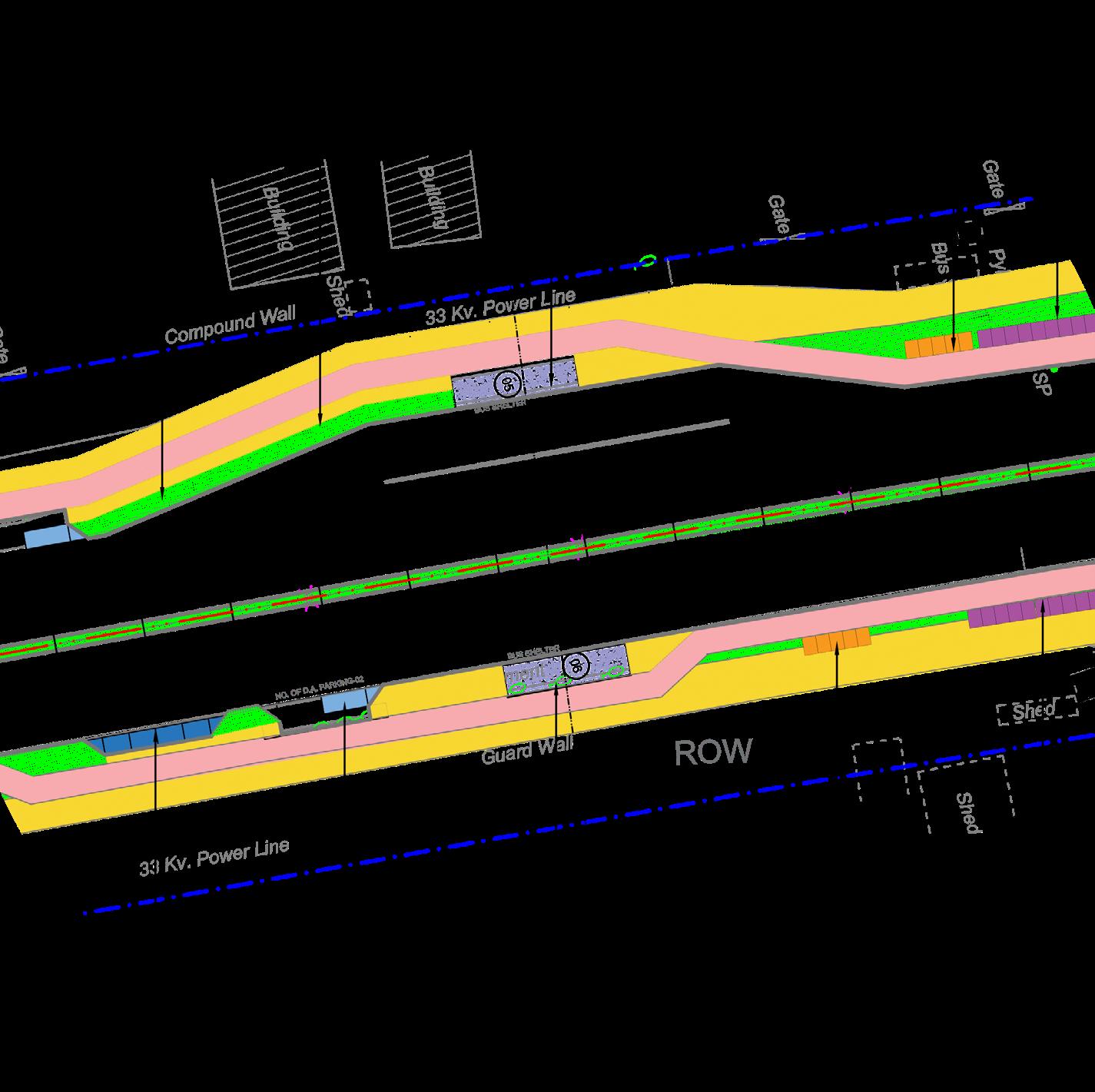
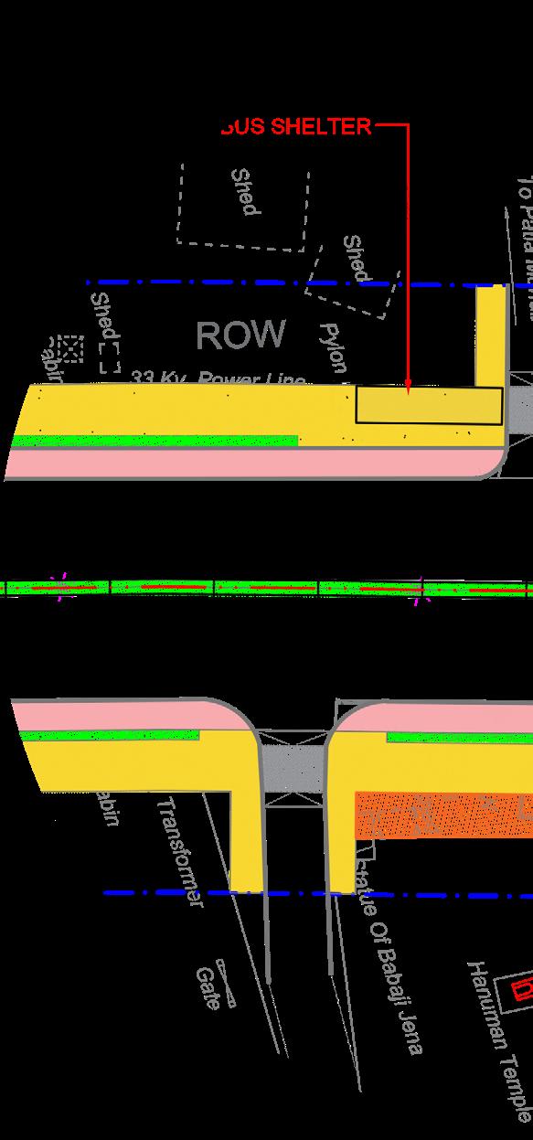


To Patiagarh Bus Stop Bus Stop Statue Of Babaji Jena 33 Kv. Power Line 33 Kv. Power Line Transformer 33 Kv. Power Line 33 Kv. Power Line Patia Chowk To Patia Mahabir Nager Hanuman Temple Compound Wall Tiled Foot Path Pavement Gate Gate Pylon SP SP SP SP Cabin Cabin SP SP EJB Shed Shed Pylon Guard Wall Tiled Foot Path Pavement Shed Shed Pylon Cabin Shed Compound Wall PostTraffic SP Transformer Cabin Shed Hut Gate Shed POW Stage SB Building Gate Pavement Pylon Tiled Footpath Gate 8100 8120 8140 8160 8180 8200 8220 8240 8260 8280 0 0 3 8 8320 8340 8360 0 8 3 8 05 06 BUS SHELTER BUS SHELTER ROW ROW SERVICE LANE NO.OFD.A.PARKING-02 PANTALOONS NO. OF CYCLE PARKING-10 AUTO RICKSHAW BAYS : 04 FOUR WHEELER BAYS : 06 BICYCLE BAYS : 10 BICYCLE BAYS : 10 BICYCLE BAYS PBS DOCKS : 05 HANDICAP PARKING BAYS : 02 BUS SHELTER EXISTING BUS SHELTER Bus Stop Bus Stop Statue Of Babaji Jena 33 Kv. Power Line 33 Kv. Power Line 33 Kv. Power Line To Patia Mahabir Nager Hanuman Temple Building Building Shed Compound Wall Tiled Foot Path Pavement Gate Gate Pylon SP Cabin Cabin Tiled Footpath SP SP SP Shed Cabin Cabin Cabin SB SP SP EJB Shed Shed Shed Pylon PostTraffic SP Transformer Cabin Gate Shed POW Stage SB Building Gate Pavement Tiled Footpath Gate 8100 8120 8140 8160 8180 8200 8220 8240 8260 0 8 2 8 0 0 3 8 8320 0 4 3 8 8360 0 8 3 8 PARKING MANAGEMENT PLANS EXISTING CORRIDOR PROPOSED CORRIDOR
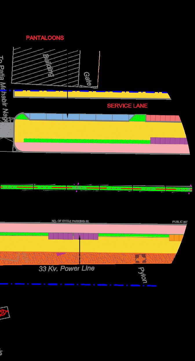


4 Allahbad Bank&coel Camps (KIIT) The Arcon Retreat Patia Sishu Bihar 11Kv. Power Line 33 Kv. Power Line MH Compound Wall Gate Pavement Building Tiled Footpath Tiled Footpath Building Shed Shed Shed Shed Shed Compound Wall g n d u B Valve Pylon TransformerGate Compound Wall Pavement 8400 8420 0 2 6 8 8640 8660 ROW SERVICE LANE SERVICE LANE BICYCLE SHARING-10 RESIDENCY PUBLIC BUILDING AUTO RICKSHAW BAYS : 04 FOUR WHEELER BAYS 04 FOUR WHEELER BAYS 04 TWO WHEELER BAYS : 15 TWO WHEELER BAYS : 10 TWO WHEELER BAYS : 10 BAYS 10 PBS DOCKS : 10 PBS DOCKS : 05 Allahbad Bank&coel Camps (KIIT) o c r A e h T Patia Sishu Bihar 11Kv. Power Line 33 Kv. Power Line 33 Kv. Power Line 33Kv.Power Line MH Compound Wall Gate Pavement Building Pylon Pylon Shed Tiled Footpath Tiled Footpath Tiled Footpath Tiled Footpath Building Shed Shed Shed Shed Transformer Gate Shed Pavement Pavement Building Gate Pylon Building Building Building Shed Shed Pylon Shed Compound Wall g n i d l i u B Valve Pylon TransformerGate Compound Wall Pavement 0 8 3 8 0 0 4 8 8420 8440 0 6 4 8 0 8 4 8 8500 8520 8540 8560 0 8 5 8 8600 8620 0 4 6 8 8660
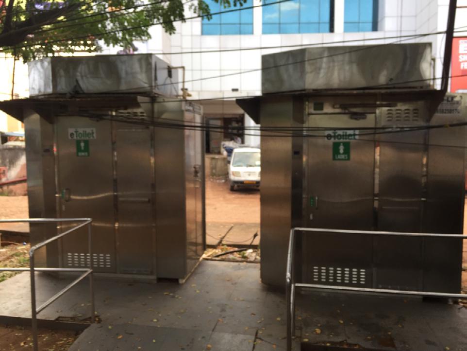
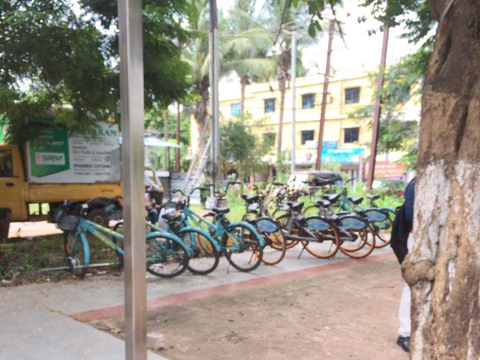
Images from Nandankanan D11 & D14 stretch, depicting the existing bus shelter, Public Bicycle Sharing (PBS) Docks as well as other public utilties been implemented by the organisation.



Images from Sachivalaya Marg of the existing Vending Zones (6.5 x 6.5 ft) authorised and provided by the BMC.

SITE SURVEY & PHOTO DOCUMENTATION - OBSERVATIONS
Immediate Proposals : KIIT Junction (Raised Junction Box and crossings, Cycle Track ahead of Pedestrian Crossing)
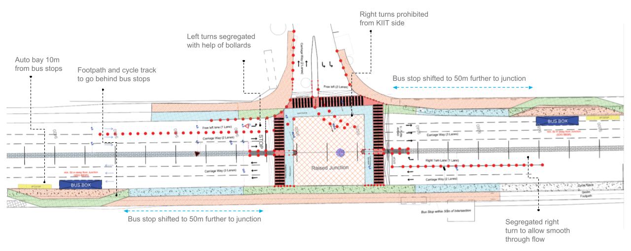

Immediate Proposals : Patia Junction Influence Area (Location of Signages, Bus Shelters, and Parking Zones)
Typical Design for Mid Block Pedestrian Crossing (Bollard Placements, Signage, Kerb Ramps)

6 KEY LEARNINGS
PROJECT 02 | URBAN DESIGN | TACTICAL INTERVENTION
TITLE : TACTICAL INTERVENTION AROUND THE PRIMARY HEALTHCARE CENTER AT KUSTIA SLUM, KOLKATA CLIENT : SAVE

THE CHILDREN INDIA FROM HERE,
PROJECT DESCRIPTION
The Urban Resilience Programme Phase-II, implemented by Save the Children (also known as Bal Raksha Bharat) aimed to increase preparedness and resilience in urban communities and schools in India. After a successful run of three years of the five-year program under Phase-II, the SHG aimed to empower the children and their communities in urban slums and targeted schools to become disaster and risk resilient through an integrated child-centric urban resilience program.
TILL HERE.
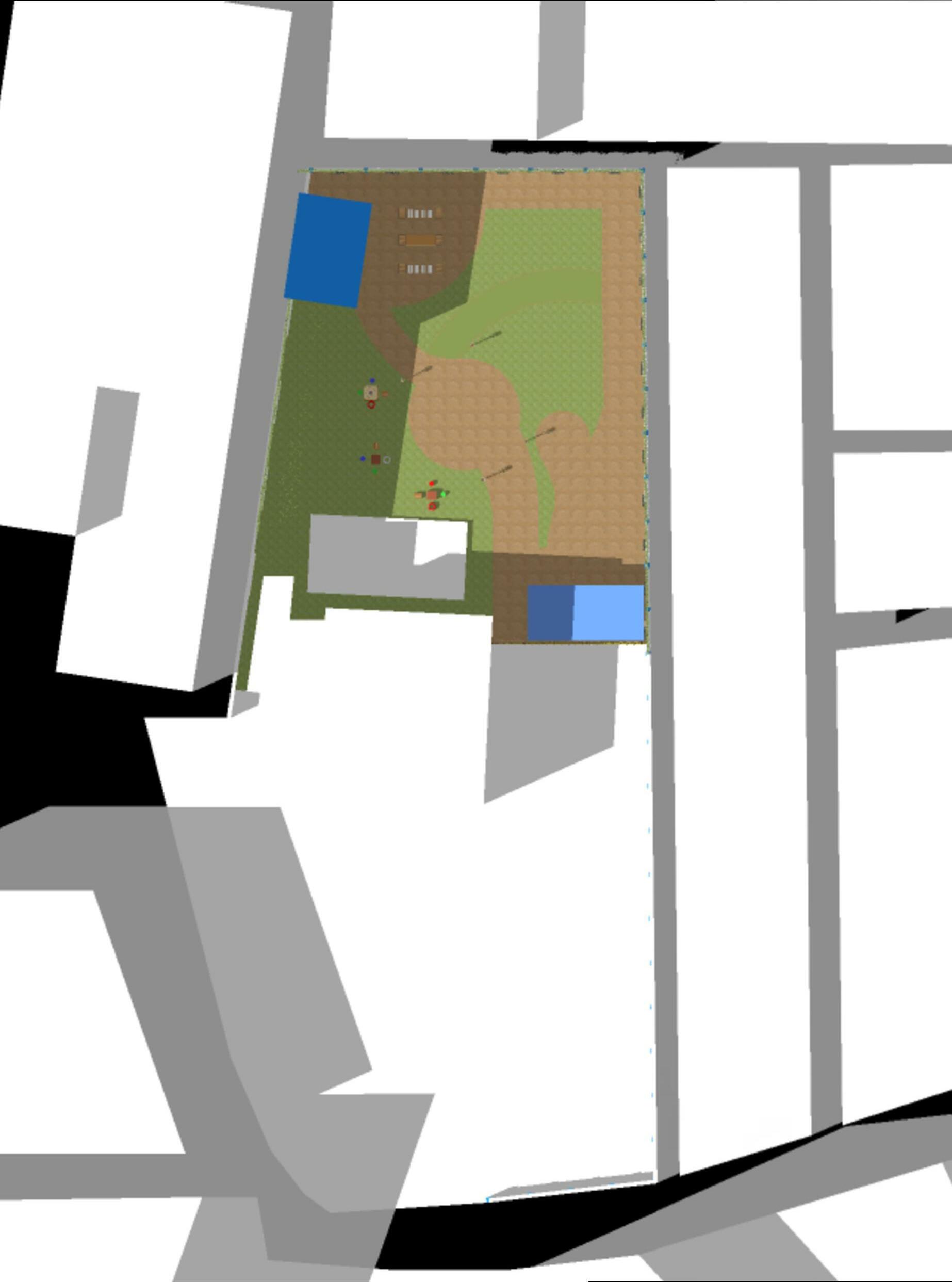
3.00 600MM high seating Patterns painted on PCC Flooring Bamboo-Framed Shaded Area Saplings planted in the ground Library and Training Center Grass cover Seatings made of plastic and wooden boxes Plastic household buckets used as seating for board games Wooden crates for seating Patterns painted on cement floor Metal Swing Site Entrance Metal See saw 10.35 7.00 3.30 2.00 3.40 3.40 6.55 4.55 10.45 11.75 7.30 3.30 Seatings made of tires and wooden boxes Planters with tire base SITE PLAN 8
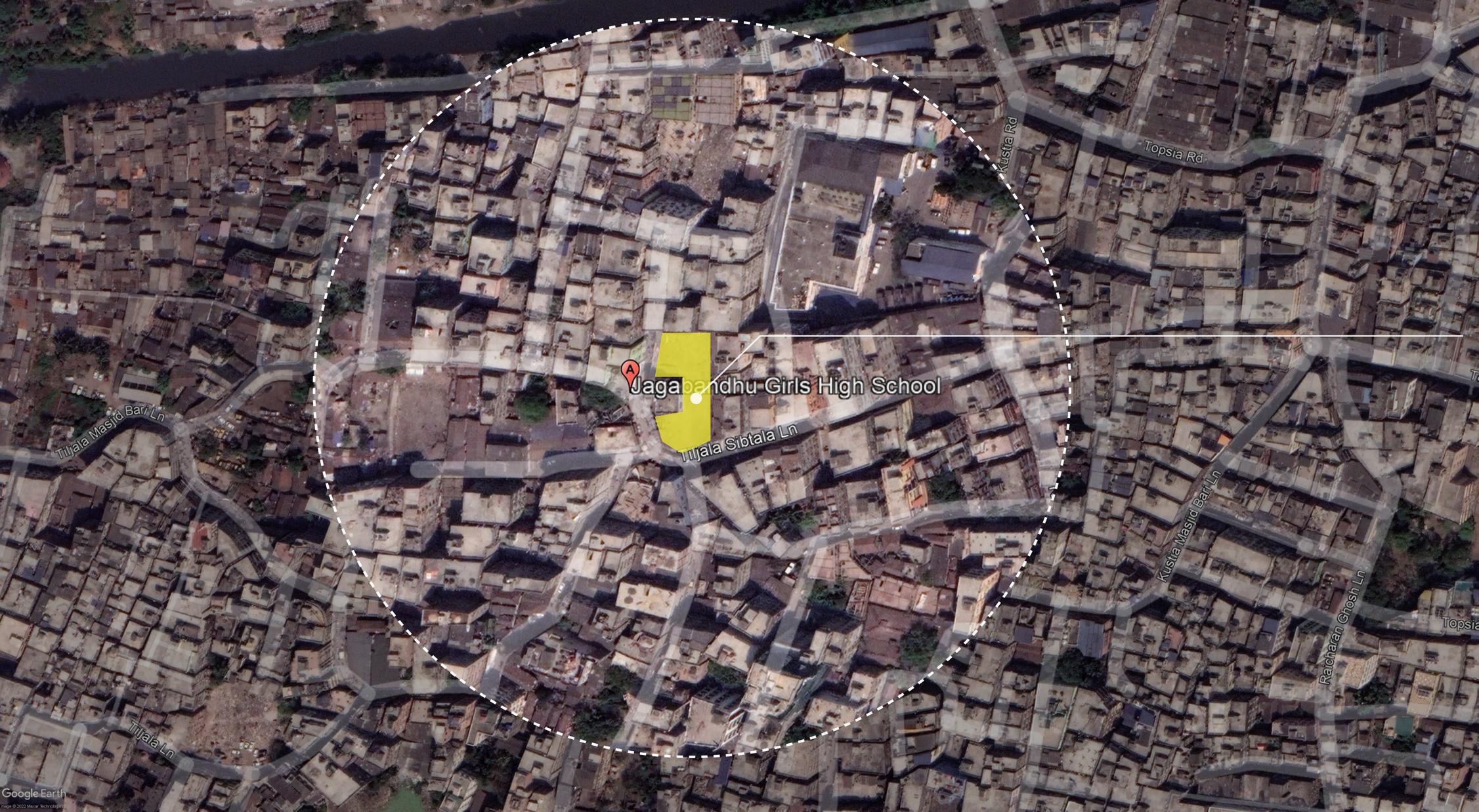
SITE DOCUMENTATION AND ANALYSIS
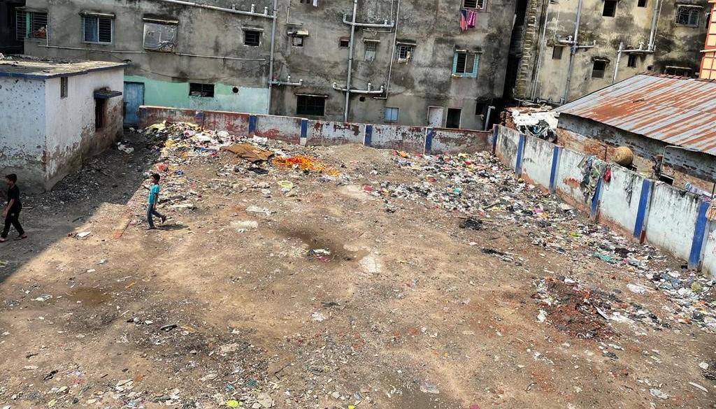
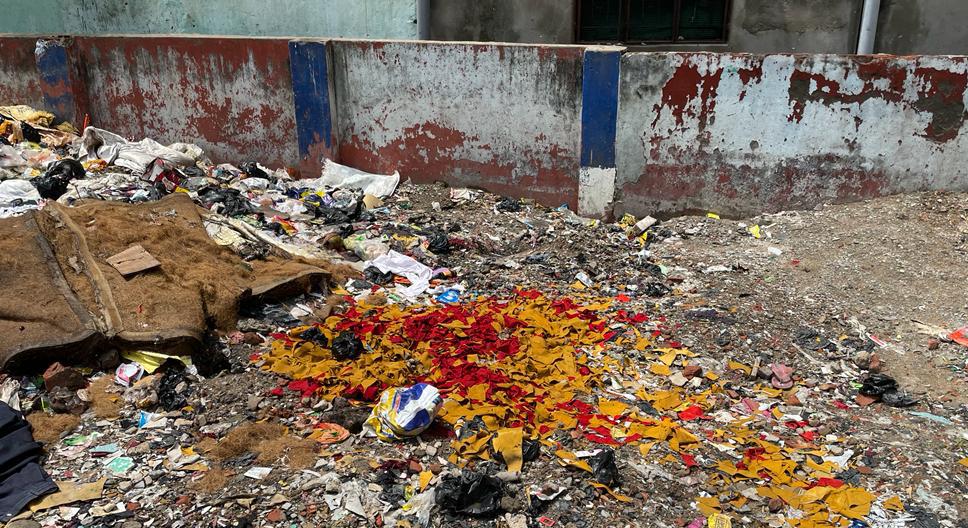
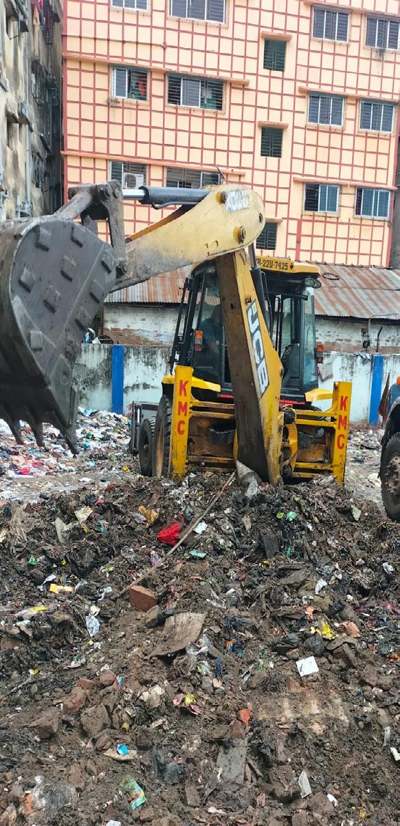
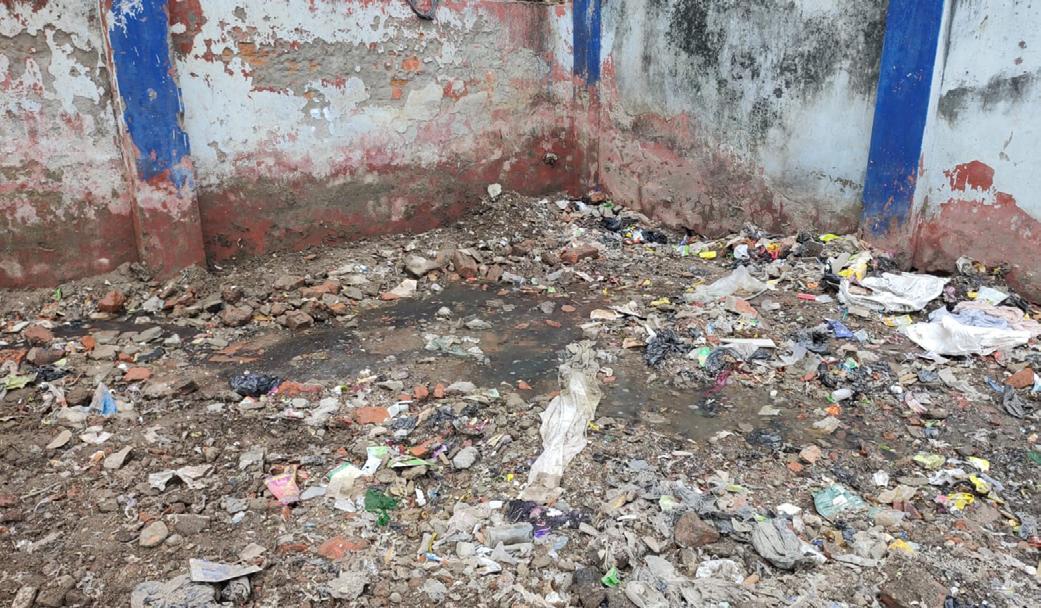
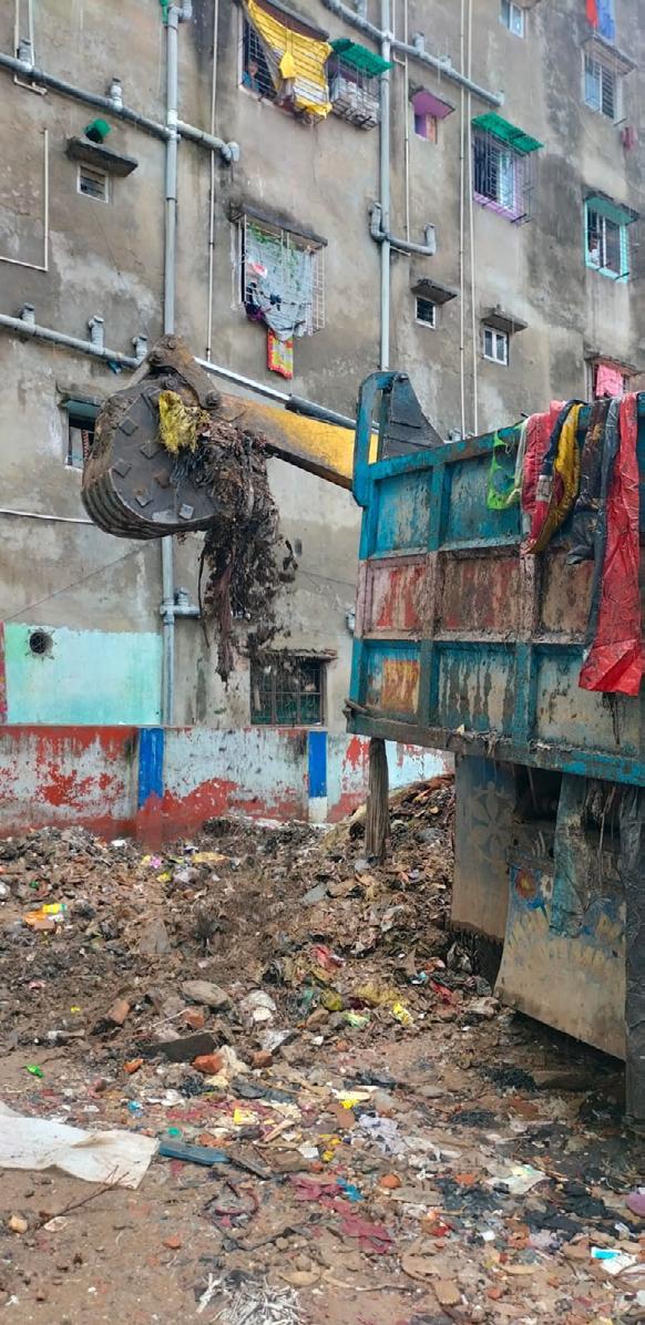
Lack of provision of public spaces or playing areas for the residents of Kustia Slum.
PROPOSED AREA FOR INTERVENTION
The site is surrounded by residential buildings, tailoring shops, leather goods manufacturing/crafting units as well as schools and congested markets on the north and west side, and a canal on the north side. Since the ward had only a few open public spaces of this scale, the chosen site for intervention became a dumping ground for solid waste from nearby buildings.
KEY LEARNINGS
Methodology towards Tactical Intervention
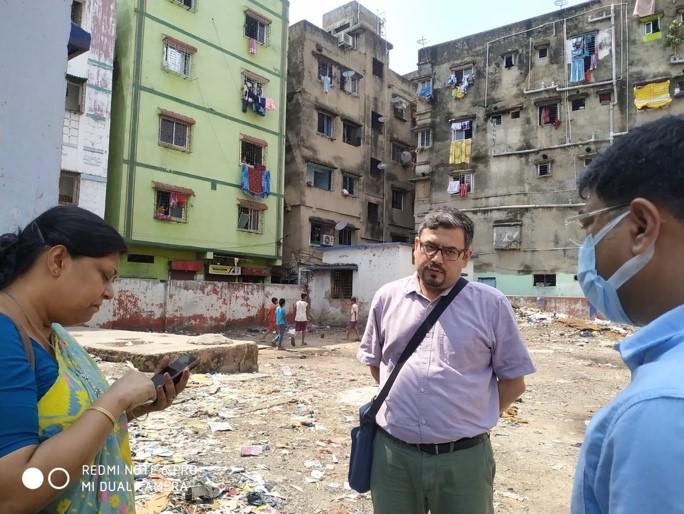
Promoting participatory design strategies, community engagement and raising awareness towards responsibility and ownership of community towards public spaces as their basic necessity.
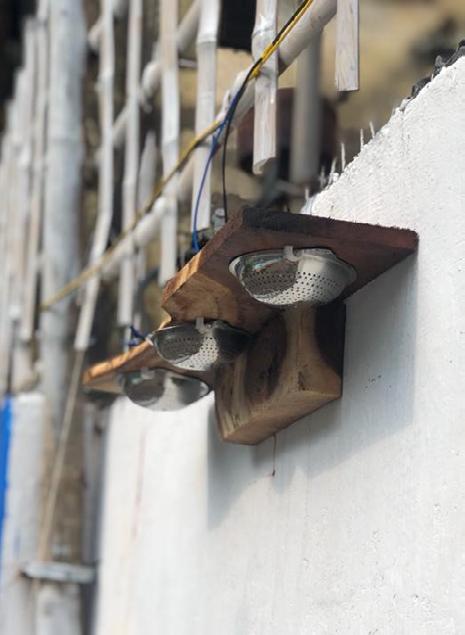

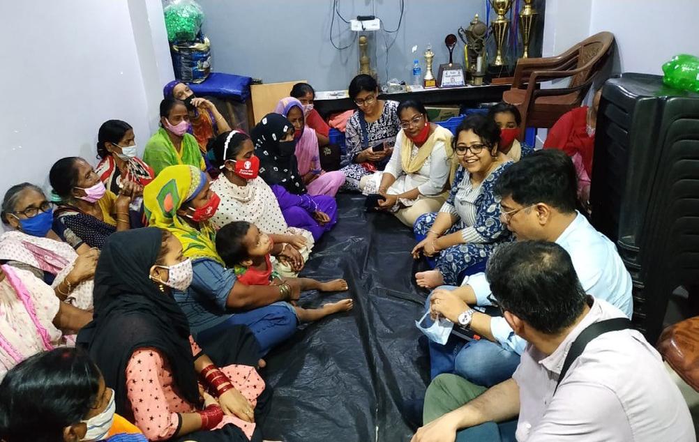
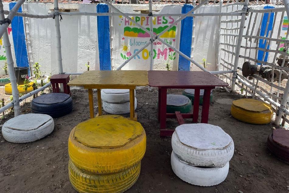
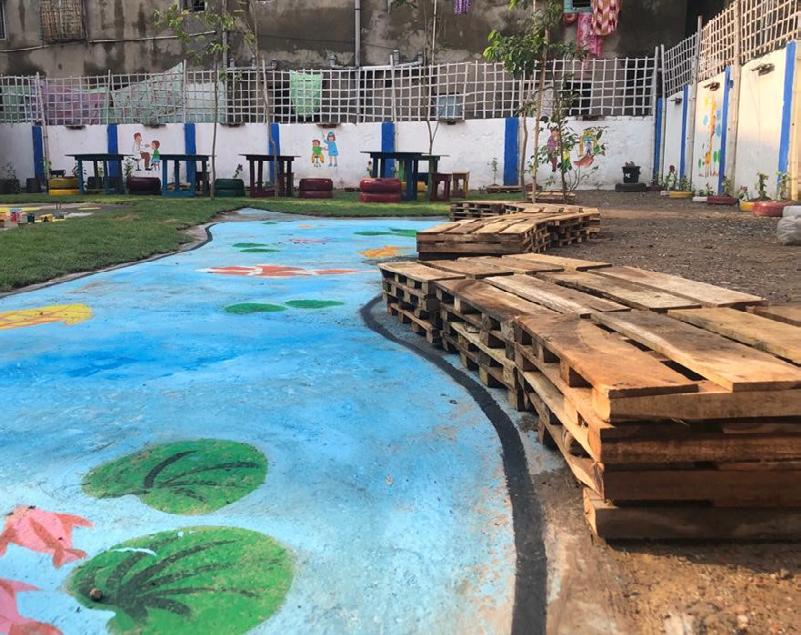

Use of recycled waste material, locally available materials and construction methods for low cost and sustainable tactical interventions.
10
Painted tires for seating Steel sieve for lighting Seatings made of wooden pallets
PROJECT 03 | URBAN DESIGN AND RESEARCH | FORM BASED CODES
TITLE
: Development of Guidebooks for Form Based Codes for Indian Cities
CLIENT : Shakti Sustainable Energy Foundation
Defining Form Based Codes
Form Based Codes (FBC) is a planning and zoning tool that is used for regulating development using physical form rather than land use segregation as the organizing principle for the code. It aims at contributing to better quality of life by fostering a high-quality public realm.
In the Indian context FBC can be adopted and applied as mandatory code, hybrid code or parallel code. The scale of application can be at the city level, area/ neighborhood level or project/ site level.
Source: Form Based Codes Guidebook, MoHUA, GOI
OVERVIEW : MANUALS FOR STATION REDEVELOPMENT INCLUDING COMMERCIAL DEVELOPMENT
Development Control Norms for Assets
Building Bye-Laws Level
Gap Analysis
Finalizing Approach & Methodology
Surveys and Preparation of Final Draft
Master Plan Level
> Horwah
> Egmore
> Shimla
> Chandigarh
> Ahmedabad
> Jodhpur
> Trivandrum
> URDPFI Guidelines 2015
> Model Building Bye Laws 2016
Detailing out the process for the assessment based on Gap Assessment
Defining outline of the assignment, detailed approach, methodology and work plan
Finalizing Outputs
Site Visits and Primary Data Collection
Preparation of Pre-Draft Version based on inputs received during Public Consultation from Experts and Advisors in National Webinars
> Horwah, Kolkata
> Dibrugarh, Assam
> Egmore, Tamil Nadu
> Trivandrum, Kerala
> Shimla, Himachal Pradesh
> Ahmedabad, Gujarat
> Jodhpur, Rajasthan
Circulating Pre-final draft among identified sector experts and others for final inputs
Expert Review & Public Consultation to encourage institutions and departments to envision the adoption and application of the draft guidebooks and provide feedback
Integrating other guidebooks on TOD, LAP
METHODOLOGY 12
Manuals for Station Redevelopment

68142448
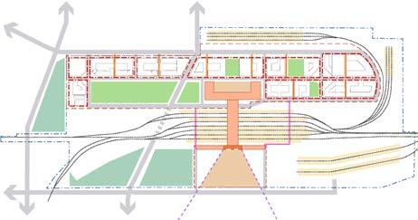
LAYOUT PLANNING URBAN DESIGN VISION
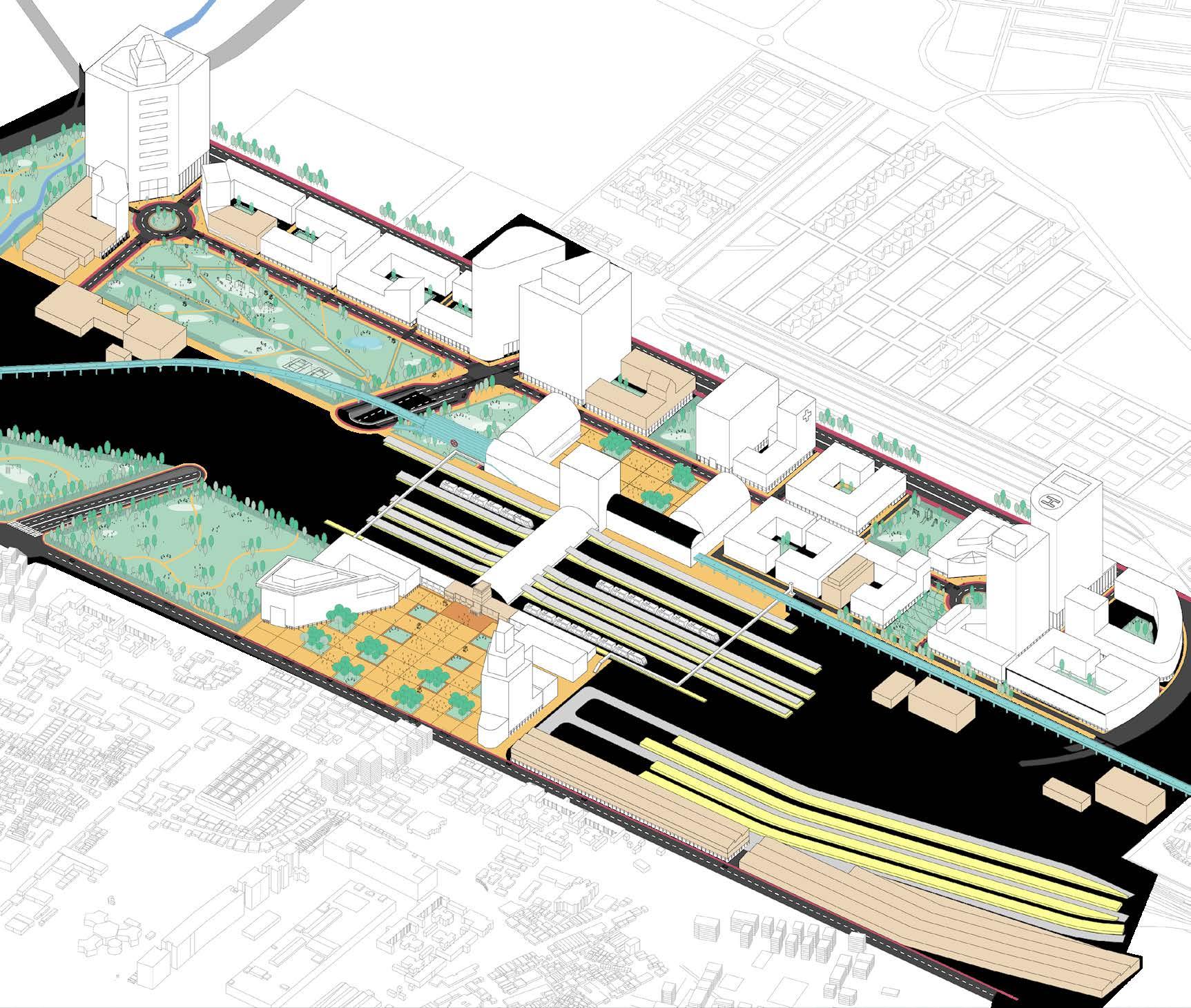
Railway Station Layout Plans shall be prepared by Technical Consultants based on the Manual-01-Handbook for Station Planning, Document 02Guidebook for Operationalizing National TOD Policy for Railway Station Redevelopment and the Manual of Standards and Specifications for Railways - 2009. The Layout Plan (including Urban Design Vision) shall be finalised and approved in consultation with the concerned Railway agencies and other stakeholders.
Station Redevelopment Land

Railway Land Setback F.A.R. and Ground Coverage
Station Redevelopment Boundary
COMPREHENSIVE PUBLIC GREEN
Streets are to distribution of space cyclists, public transport, as per Guidebook
STATION
Station Entry free public Modal Integration for emergency Handbook
Application of Local Bye Laws on Railway Land
Setback Station Design
Commercial
MARKER ELEMENTS
Marker Elements within Railway Land to be identified in Layout Plans for recognition of the site from a distance. There can be more than one such marker elements like clock towers, groups of buildings, sculptures, high rises etc. as per Guidebook 03b.
HERITAGE STATION PLAZA
Apart from providing entry, the plaza in front of Historic Stations, to be a foreground for the historic public space. Instruments of View Cone and Visual corridors to be used to define its edges as per Manual 03a, Working Policy 06a and Guidebook 03b
BUILDINGS CLOSE TO HERITAGE STATION
Buildings within close proximity to Historic Station to be designed as per controls mentioned in the Heritage Regulation Card and in compliance with Working Policy 06a and Guidebook 06b.


HERITAGE STATION EXTENSIONS


Historic Stations were modular units and for expansion. Future shall be planned following assessments as per 06a and Guidebook 06b.
- Guidebook for operationalizing National Transit Oriented Development Policy for Railway Station Redevelopment
03a - Manual of Form Codes for
development 03b - Guidebook for Codes 02
A
D
C
B
TOD Street Grid Green area network Sub-Plots for
Railway Land planning as per Handbook 01, Guidebook 02, Manual 03a and Working Policy 06a. Final Layout Regulating Plans with Station Operational Areas, Sub-Plots, Green Areas, Transport Network, et al. Development
The Technical Consultant shall prepare and submit, Property Development Card for each Sub-Plot, based on the approved Layout Plan and 03a Manual of Form Based Codes for Station (Re)development.
01 - Handbook for Station Planning Registered and Corporate Office: 7th Floor, Tower-1, Konnectus Building, Bhavbhuti Marg New Delhi 110002 Tel:
Fax:
info@irsdc.in www.irsdc.in
Large public green areas act as lungs for the site and are for community use, events, water recharging, et al, as per Guidebook 02.
Station
68142400 ;
Redevelopment including Commercial Development
COMPREHENSIVE STREETS
be planned with equitable space for all modes - pedestrians, transport, private vehicle et al Guidebook 02 and Manual 03a.
STATION ENTRY PLAZA
Entry plaza to be a barrier public space, enable Multi Integration and also be used emergency evacuation as per 01 and Guidebook 02.

COMMERCIAL GARDEN
Green areas surrounded by commercial use to be managed as landscaped gardens above basement parking or other sub-surface uses as per Manual 03a and Guidebook 03b.

NMT ONLY STREETS
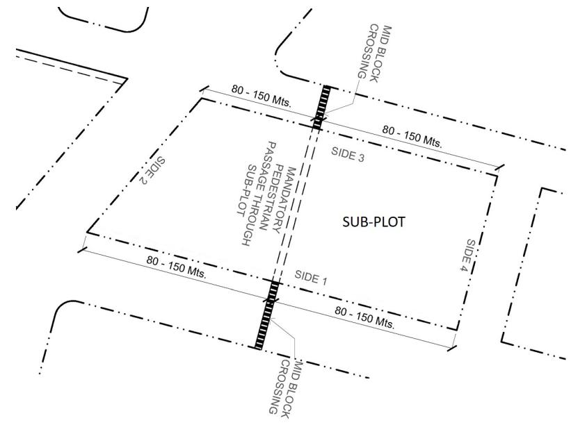
Streets providing shortcuts for pedestrians and cyclists through SubPlots with private development as per Manual 03a and Guidebook 03b.
HIGH RISES
High rise towers allowed. Compliance as per Handbook 04b and Guidebook 05.
DEVELOPMENT OF SUB-PLOT
Developer appointed for any Sub-Plot shall adhere to the approved Railway Station Layout Plan, Manual 03a and its respective Property Development Card.
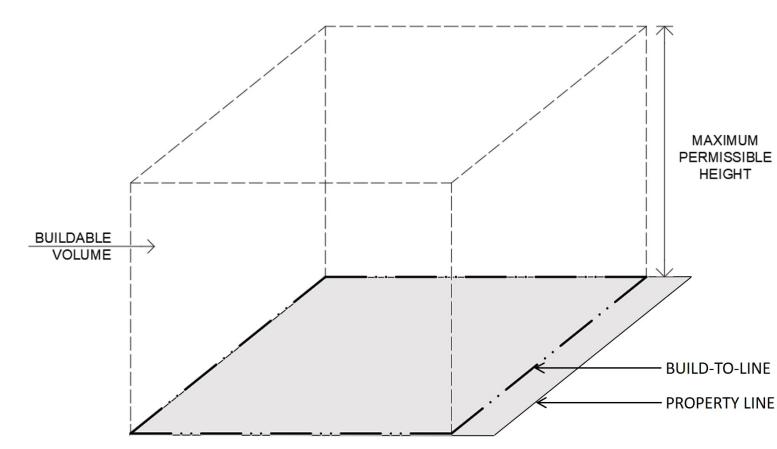
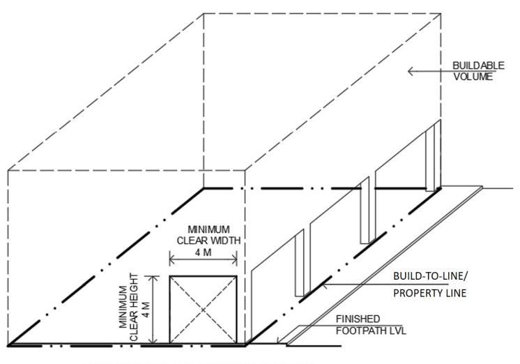
Each Sub-Plot of the Layout Plan has its unique Property Development Card (PDC), comprising at-least Buildable Volume Card (BVC), Street Regulation Card (SRC), Open Space Regulation Card (ORC) and Heritage Regulation Card (HRC). The PDC provides applicable Form Based Codes and integrate it with the Layout Plan.
A
Sub-Plot Form Based Codes relate to its Boundary and Property Development Card.


Sub-Plot development to follow Form Based Codes in Property Development Card.
STATION
were designed as with provisions Future expansions following essential Working Policy 06b.

ACTIVE FRONTAGE CHILDREN’S PARK
All buildings to have Active Frontage along roads and streets for common use. Shaded colonnades to be provided as per Manual 03a and Guidebook 03b.
Green areas surrounded by residences to be maintained as nongated Children’s Park as per Manual 03a and Guidebook 03b.
Sub-Plots may have any Use(s) and Built Form(s), as per Manual 03a, Working Policy 06a and Guidebook 06b.
Note: For Heritage Stations, also refer 06a: Working Policy for Railway Heritage Assets and 06b: Guidebook for Conservation of Railway Heritage Assets.

C B
SUPPORTED BY | Shakti Sustainable Energy Foundation PRODUCED BY | Creative Footprints & Ekatra Design Associates
06a - Working Policy for RHA 06b - Guidebook for Conservation of RHA 06c - Background Studies for 06a and 06b 05 - Environment Management Guidelines for Station (Re) development Form Based Station (Re) for Form Based 04a - Manual for Building Plan Approval of Commercial Assets 04b - Handbook for Architectural Design of Commercial Assets
GAP ASSESSMENT : PLOT LEVEL
Comparative Matrix for Gap Assessment at Plot Level S. No. Terminology from IRSDCs Manuals for Station Redevelopment Including Commercial Development Howrah Chennai Shimla Chandigarh Jodhpur Ahmedabad Trivandrum URDPFI MBBL 1. MSDCD - Manual for Station (Re)Development including Commercial Development 2. A - Absent 3. P – Present 4. RR - Requires Rationalization 5. URDPFI 2016 - Urban and Regional Development Plan Formulation and Implementation Guidelines, 2016 6. MBBL 2016 - Model Building Byelaws, 2016 1 Active Frontage A P P A A P P P RR 2 Build-to-line RR RR RR RR A RR RR A P 3 Buildable volume A A RR RR A A A A RR 4 Common Areas A P P A A RR RR P RR 5 Common Green Areas A A RR A A A RR RR RR 6 Common Plaza P P A RR A P A P RR 7 Mandatory Pedestrian Plaza A P RR RR A A A RR RR 8 Mandatory Vehicular Passage A RR A A A A RR A RR 9 Marker Element A RR A A A RR RR A RR 10 Pedestrian colonnade A A A A A RR RR A P 11 Permitted Projection P A A A A RR RR A A 12 Plot P P P A A RR RR A P 13 Property Line A A A RR A RR RR P P 14 Sub-Plot A RR A A RR RR RR RR RR 15 Super Structure A A P P A RR RR A A 16 Under Ground Structure A RR RR RR A RR RR RR RR
The plot level regulations contributing towards design of interface of Urban Environment are ound in the Building Bye Laws, which derive its basis from the Development Control Norms of the local Master/ Development Plans. To understand the Gaps in regulations of urban form vis-à-vis plot development, the FBC parameters of IRSDCs Manuals have been compared with the building bye laws of selected cities, URDPFI Guidelines and MBBL. The summary of findings is provided in Table 1 below and explanation thereafter.
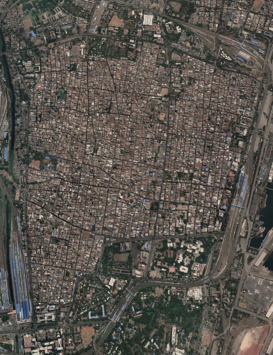
SITE DOCUMENTATION : MAPPING Low-Density Residential Mixed Use Commercial High-Density Commercial Mixed Use Medium-Density Commercial Mixed Use Public-Semi Public Use Industrial 16
Comparative Matrix for Gap Assessment at Layout Level S. No. Terminology from IRSDCs Manuals for Station Redevelopment Including Commercial Development Howrah Chennai Shimla Chandigarh Jodhpur Ahmedabad Trivandrum URDPFI MBBL 1. MSDCD - Manual for Station (Re)Development including Commercial Development 2. A - Absent 3. P – Present 4. RR - Requires Rationalization 5. URDPFI 2016 - Urban and Regional Development Plan Formulation and Implementation Guidelines, 2016 6. MBBL 2016 - Model Building Byelaws, 2016 1 Street Alignment P P A A A P P A RR 2 Public Street RR RR RR A RR RR A A RR 3 Street Length A A A A A A RR A A 4 Street Parts A A A A A A A A A 5 Junction A RR A A RR RR RR RR P 6 Primary Street A A A RR A RR A P A 7 Secondary Street A A A RR A RR A P A 8 Tertiary Street A A A RR A RR A P A 9 NMT Street Only A A A A A A A P A 10 Mid-block Crossing A A A A A A A A A 11 Footpath RR RR RR A A RR RR P P 12 Dead Width A A A A A A A P A 13 Multi-functional /Multi-utility zone RR A A A A A A RR A 14 Open Space A RR RR RR A P P P P
The Master/ Development Plans of Indian Cities are Planning tools which establish the Plan vision of a city, the allocation of resources and indicates the vision for its Urban Environment. These also define the Urban Design Vision for the city. The Form Based Codes are regulatory tools to implement design of urban environment defined in its Master/ Development Plans. As such the Parameters of Layout Planning from IRSDCs Manuals for Station Development including Commercial Development have been compared with the Master/ Development Plans of the seelcted cities, URDPFI Guidelines and Building Bye Laws. The summary of the findings is provided in the table below:
GAP ASSESSMENT : LAYOUT LEVEL
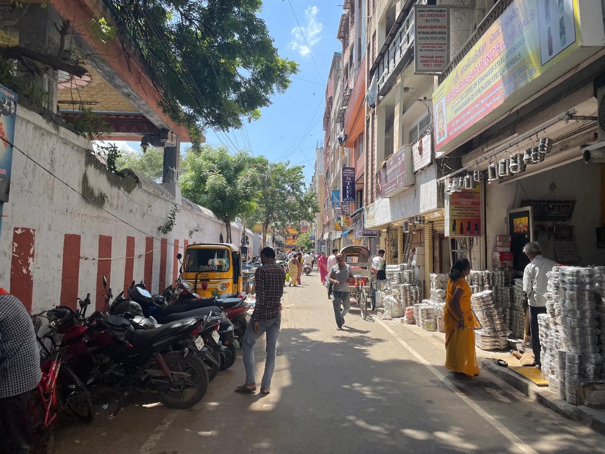
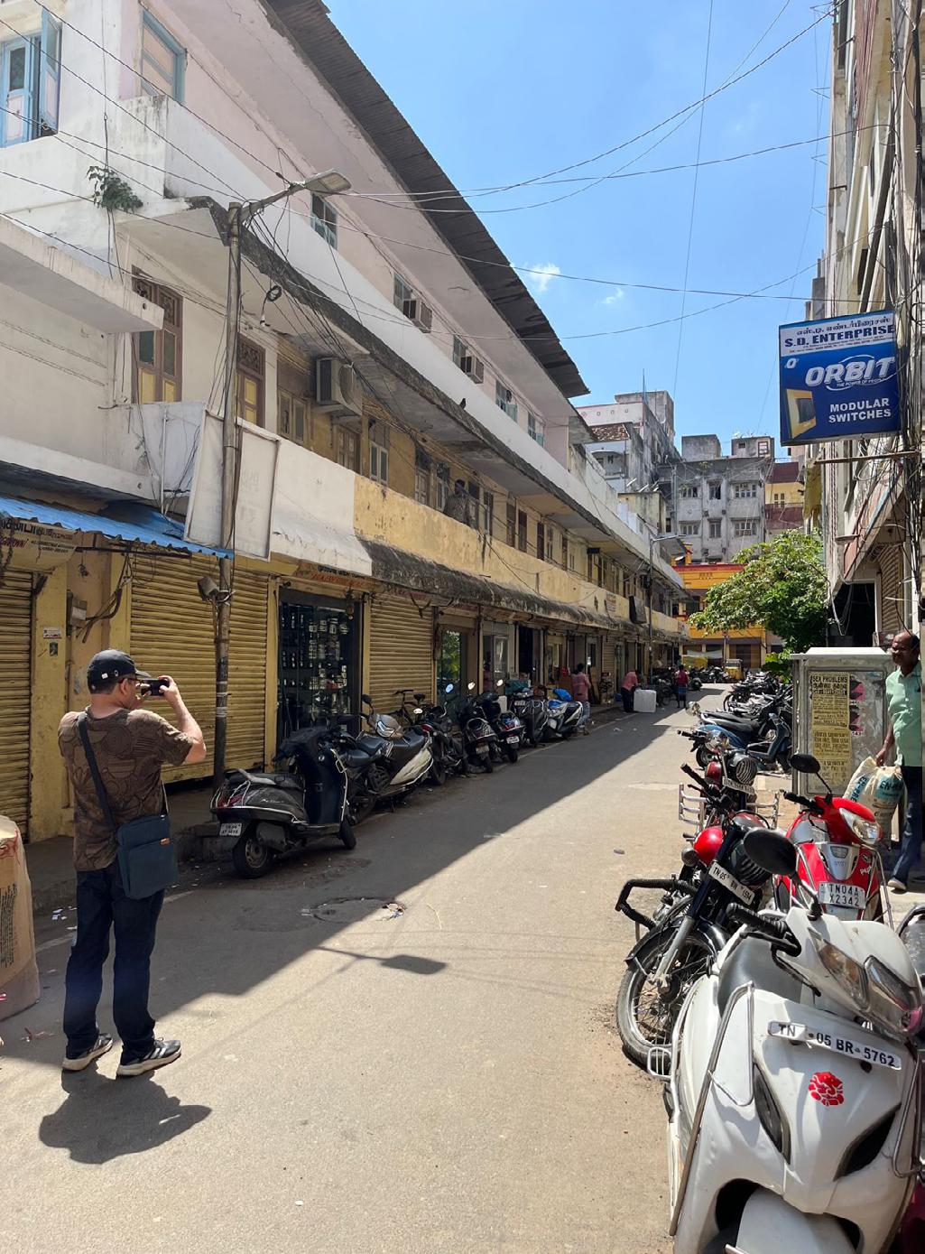
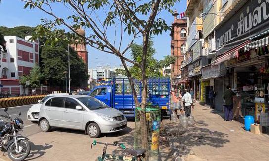
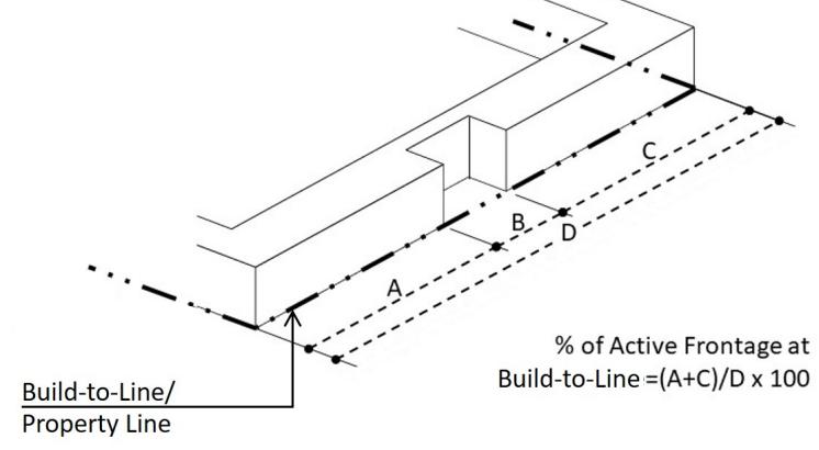
Active Frontage Dead Frontage (For Parking) Recessed Ground Floor Projections for Shaded Balconies Pedestrian Footpath Authorised Parking Mixed Use Development SITE DOCUMENTATION : OBSERVATIONS 18
PROJECT 04 | ARCHITECTURE | DESIGN COMPETITION
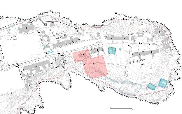
TITLE : SPORTS HALL DESIGN COMPETITION, SCINDIA SCHOOL, GWALIOR
CLIENT : SCINDIA SCHOOL
MAIN ENTRANCE
Primary entrance to the Scindia complex. Beyond this point, private vehiclar movement is prohibited for visitors.
CENTRAL AXIS
Main pedestrian and public transport circulation axis of school. Private vehicular movement is prohibited.
SITE FOR HALL
Proposed site for Multi Purpose Hall. The existing site also housed the medical block, water pump and an untraceable heritage structure.

LEGEND
1. DINING HALL
JAYAJI HOUSE
RANOJI HOUSE
MAHADJI HOUSE
JEEVAJI HOUSE
JAYAPPA HOUSE
DAULAT HOUSE
SHIVAJI HOUSE
MADHAV HOUSE
DHOBI TAAL
STAFF RESIDENCE
MEDICAL BLOCK
ACADEMIC BLOCK
SCIENCE BLOCK
7.
11.
12.
13.
14.
15.
2.
3.
4.
5.
6.
8.
9.
10.
O.A.T.
KEY PLAN
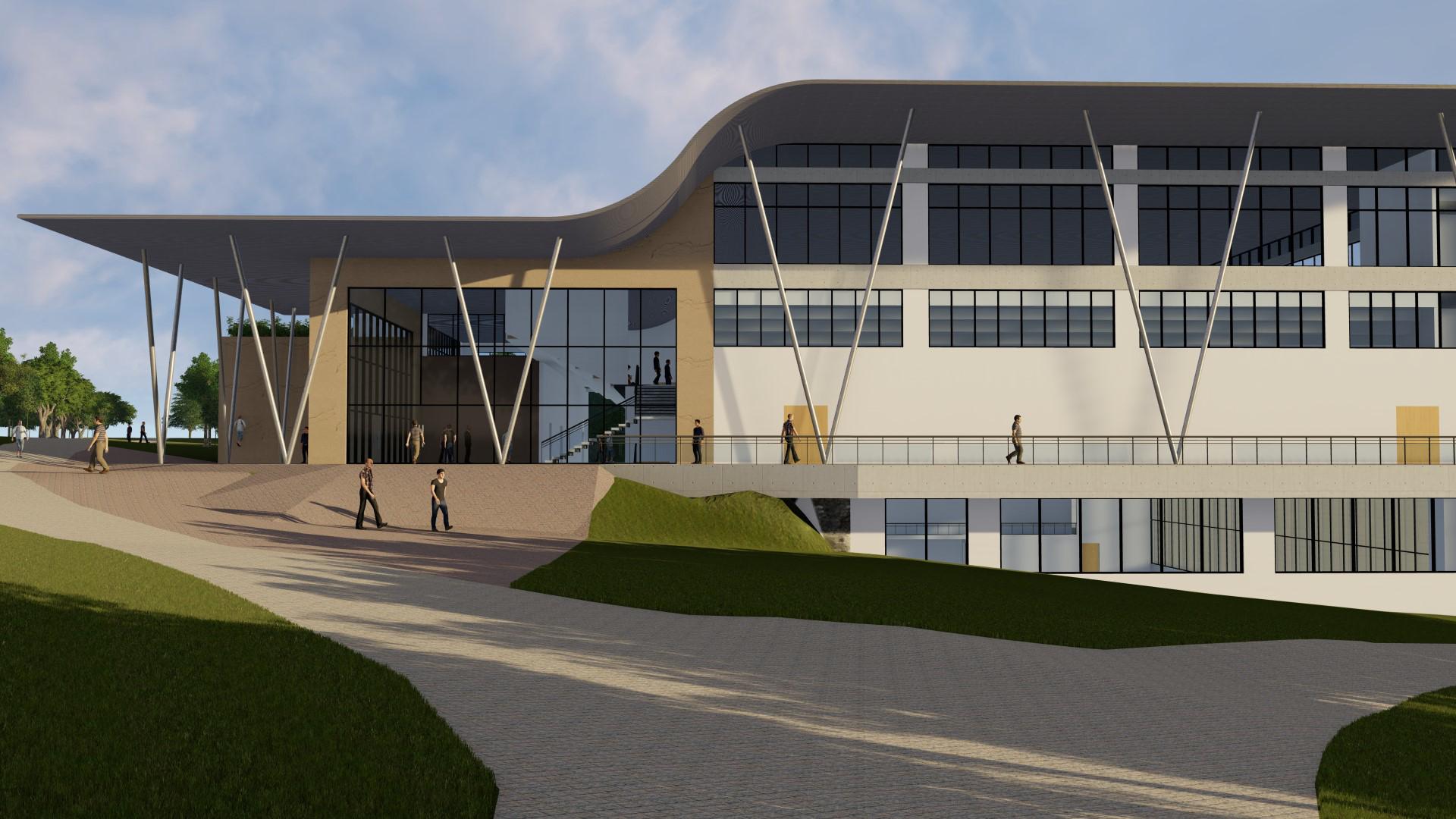
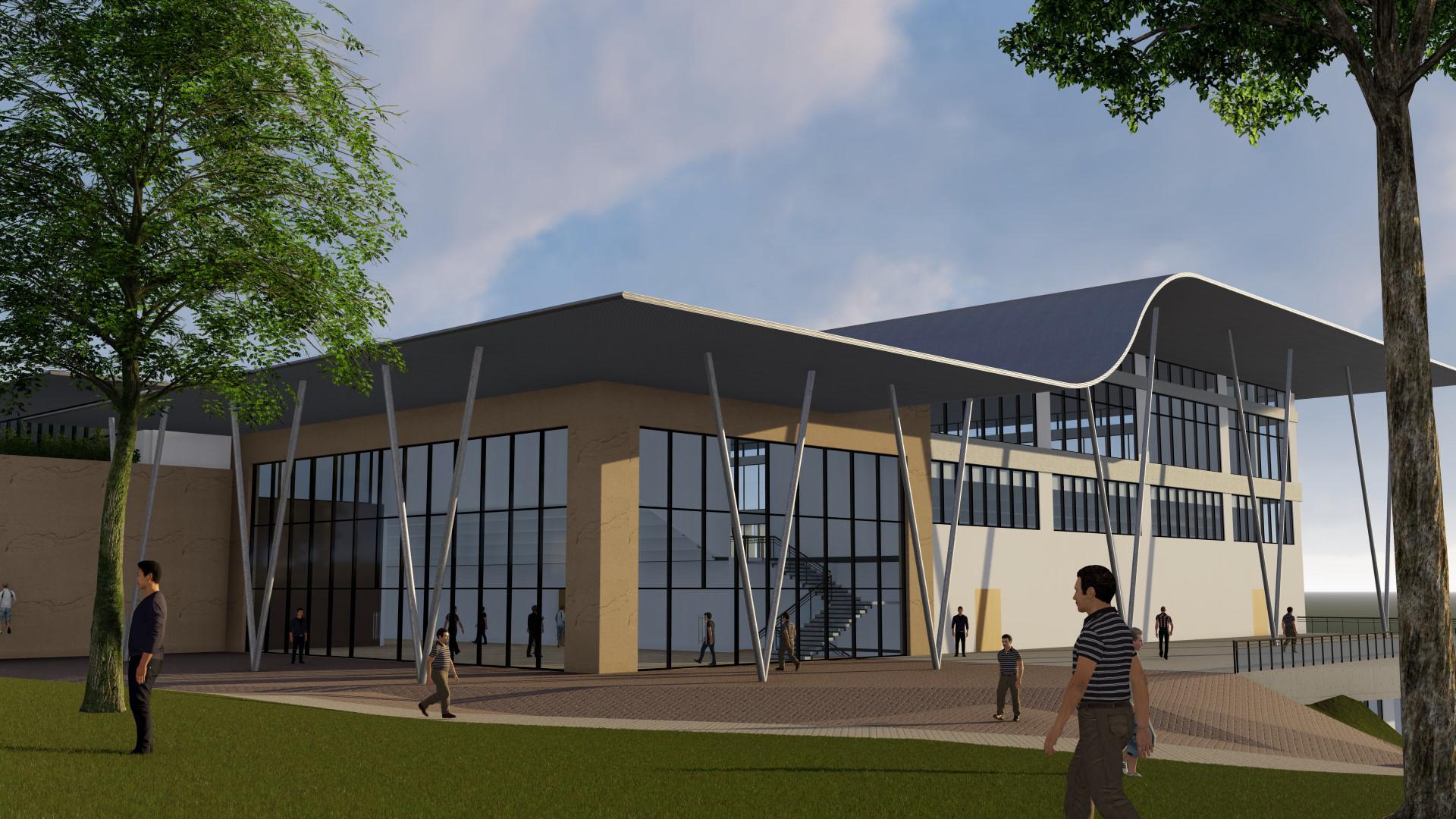
The location of the facility is such that the built mass is visible from the city. This built mass, therefore, creates a skyline of the Tier-II city, signifying it's importance.
20
View from Asthchal, the evening route for students' exercises. The sports facility acts as a nodal point between the various Scindia School Hostels, as well as two OATs and staff quarters.
SITE PLAN AND FORM DEVELOPMENT

O.A.T.
The large open air theatre located beside the proposed MPH site provides a visual point for the students and staff.
PERIPHERAL ROAD
Acts as the main vehicular connection between the Gwalior city and the Gwalior Fort.
CROSS-LINKING ROAD
Connects the peripheral road with the Scindia Complex.
Exisiting Site
SECONDARY PLAZA
The secondary entrance acts as the main plaza for students due to easy accessibilty from student houses. Also connects the sports facility with Asthchala (O.A.T.).
Placement of building blocks aligned with existing buildings.
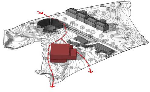
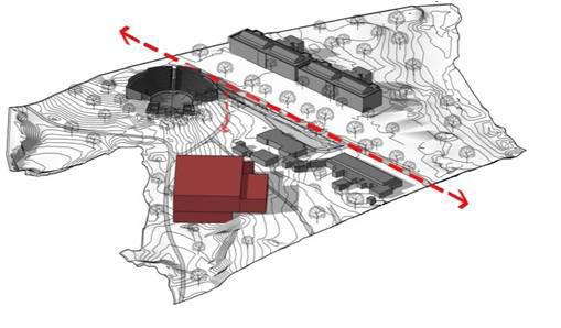
Proposed away from central axis; doesnot dominate existing skyline.

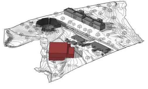

Building Placement retains existing circulation and structure on site.
22
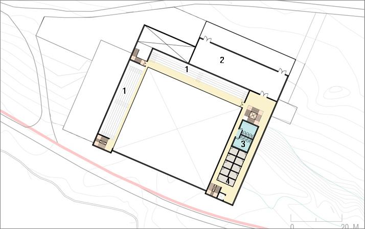
PLAN at LVL +3 METERS
The top most level of the sports hall. Houses 750 seats for visitors, along with toilets as well as offices for the sports officer.
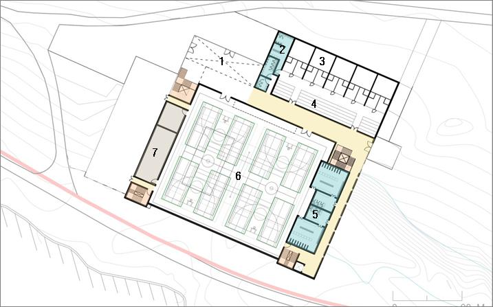
PLAN at GROUND LVL
The ground floor plan that houses the main sports hall along with changing rooms, team rooms as well as lockers for the respective sports teams. Along with servives for sanitation and maintenance, the ground floor also houses the Squash Court facility with 200+ seatings and services. The entrance foyer connects all the services via staircases and lifts.
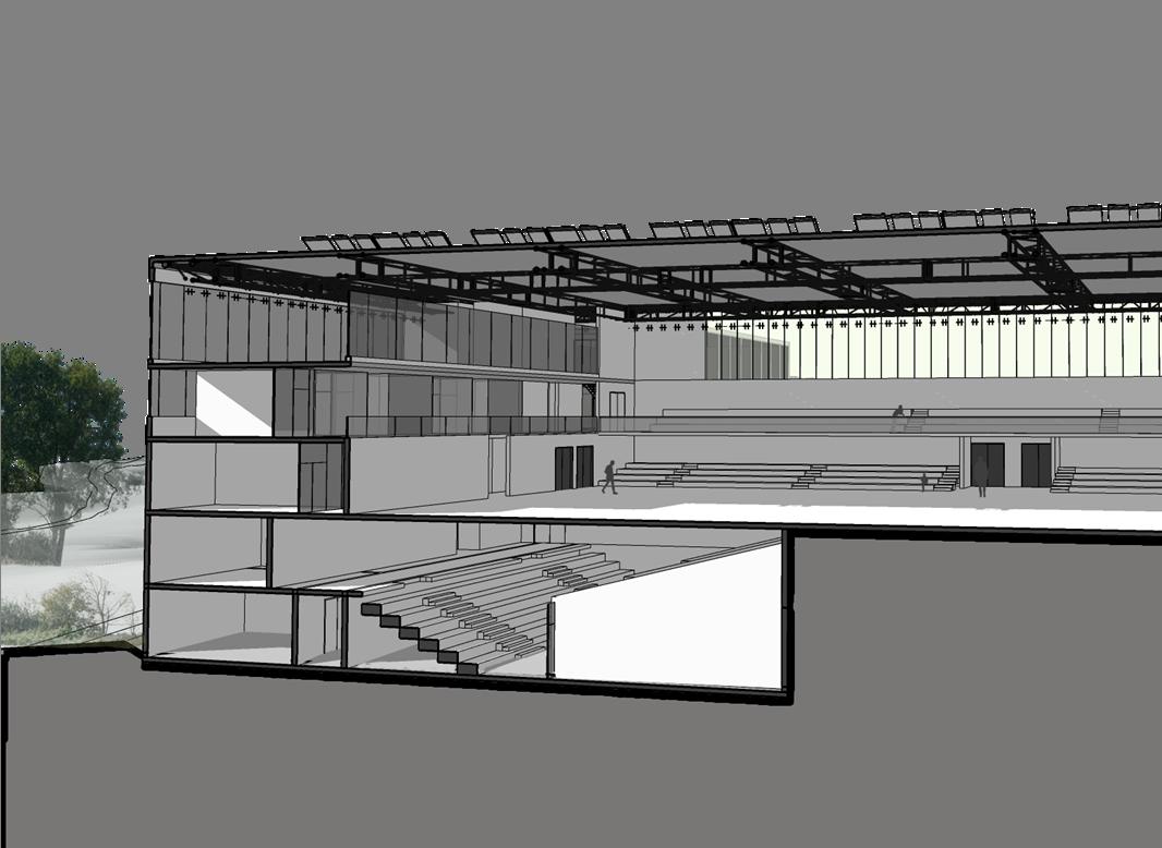
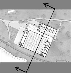
SECTIONAL VIEW
PLAN at LVL -3M
Below the ground floor comes the lower ground floor, equipped with seating of 650 people for swimming competitions.
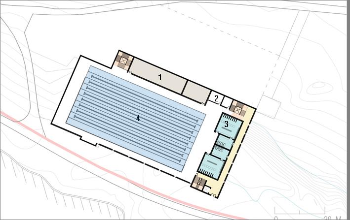
PLAN at LVL -6M


The lowermost level of the sports facility, housing the Olympic Size Swimming pool, In-house Sewage treatment plant as well as office of the sports officer. Furthermore, the floor is also equipped with toilets, changing rooms as well as storage facility for necessary services.
24
KEY PLAN
Chetan Aggarwal
Tel : +91-9958906176
E-mail : chetan.aggarwal1812@gmail.com
Address : Sector 13, Rohini, New Delhi - 110085


