
20 minute read
PROOF: How Small Drones Can Find Buried Landmines in the Desert using Airborne IR Thermography
By John Fardoulis [ Mobility Robotics ], Xavier Depreytere, Pierre Gallien, Kheira Djouhri, Ba Abdourhmane, and Emmanuel Sauvage [ Humanity & Inclusion ]
Image 1. An onus on proof—moving the needle under actual field conditions at 30-year-old legacy desert minefields in Chad. All graphics courtesy of authors.
Advertisement
Hypotheses and speculation have circulated for at least three decades regarding how IR thermography could be viable as a technique for locating buried landmines in arid environments. However, there has been a lack of proof under actual field conditions. To the best of the authors’ knowledge, no previous research occurring before October 2019 validated how temperature anomalies could be identified under field conditions by small unmanned aircraft systems (i.e., drones) using thermal/long wave infrared (IR or LWIR) imaging, also known as thermography, to indicate the location of buried anti-personnel and anti-tank landmines in legacy desert minefields. Evidenced-based and field driven, Mobility Robotics and Humanity & Inclusion (formerly Handicap International, HI) established new, state-of-the-art knowledge in October 2019 regarding the use of small drones in humanitarian mine action (HMA). Airborne data collected via drones indicated the position of more than 2,500 legacy, in-situ landmines in Chad.
Addressing many overall questions regarding small drones in HMA, the Odyssey2025 Project—led by HI and Mobility Robotics— closely collaborated with the national mine action center in Chad, the Haut Commissariat National au Déminage (HCND), to complete activities and objectives. As part of a holistic approach, the primary objective was to determine how small drones could add value in HMA field operations and augment other assets at both simple and advanced perspectives. This research is from an advanced perspective, following on from the work previously published in The Journal of Conventional Weapons Destruction outlining how low-cost consumer drones can augment HMA operations at a simple level using visual imagery and GIS/cartography/photogrammetry.1
This article aims to advance the field’s understanding of drones and their ability to indicate the location of buried objects. Elements that set this work apart from other drone and thermal/LWIR research over recent years include:
1. a concentration on buried objects;
2. the capturing of in-situ airborne data at active, legacy minefields;
3. the burying of production landmines containing real explosives to capture high temporal resolution data at a controlled field test site;
4. an onus on proof in a harsh, remote, real-world environment— incorporating local weather and environmental influences—that
5. provides validation under actual field conditions; and the applied activities that took place with HMA actors to develop a practical, real-world methodology that achieves a humanitarian impact.
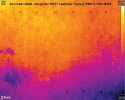
Figure 1. In-situ minefield data captured by a small drone from a height of 35 m above ground level (AGL) in Chad. Anomalies from twenty-seven legacy buried landmines are visible in this thermal/LWIR image. Thirteen PRB-M3A1 anti-tank landmines are in rows at the top and bottom. Fourteen PMA-3 anti-personnel landmines are in the two middle mine rows.
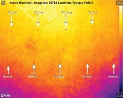
Figure 2. Above, anomalies from nine PMA-3 anti-personnel landmines can be seen from a flying height of 25 m AGL in this thermal/LWIR image. The PMA-3 is cold when on the surface at night (darker surface dot above), whereas the PRBM3A1 and PPM-2 are warm when interfacing with the air at night.
HYPOTHESIS
Buried landmines interfere with how temperature is stored in and travels through the ground, creating hot or cold patches on the surface above buried objects. The different surface temperature above the buried landmine is an anomaly, an indicator of where contamination exists beneath. The strength and timing of when a hot or cold patch appears during the day or night depends on many complex weather and environmental variables at the time.2–6
HMA SCOPE
Presently, the scope of thermal-camera-equipped drones in HMA is to use them as a survey tool and during planning and evaluation phases, to better define the types of landmines present, locations of mine rows, and contamination densities in arid (and perhaps semi-arid) environments. Operating from a safe distance outside of the minefield, users can leverage drone technology to pinpoint where buried landmines exist in order to more effectively and efficiently use ground assets such as manual deminers and animal/mechanical assets. By first mapping patterned minefields, operators can apply lessons learned to deal with more complex minefield layouts. Drone technology is a survey tool, which does not work in isolation, so missing some landmines is acceptable as the missing objects will be found by ground teams when they undertake technical survey or clearance work.
A challenge in HMA is pinpointing where contaminated areas are located within larger suspected hazardous areas (SHAs). Systematic approaches across a general area are necessary for safety but can mean that millions of dollars are spent sending ground assets to areas where landmines do not exist. Starting clearance from where landmines exist and working from the inside of a minefield outward, operators can potentially reduce the size of work areas where ground assets are deployed. Hence, there is potential for drone technology to reduce costs, accelerate land release, and improve safety in arid and perhaps semi-arid environments.
MATERIALS AND METHODS
The Odyssey2025 Project included the following field validation and data collection elements:
1. Field validation regarding the viability of airborne IR thermography involved remotely collecting in-situ landmine data via drone over legacy minefields during the hot and cold seasons of October 2019 and March 2020 respectively.
2. High temporal and spatial resolution data was captured at a controlled field test site using production landmines recovered from surrounding minefields (minus fuzes). These mines were buried at known depths inside the perimeter of actual minefields (Figure 3b). The controlled field test site continuously captured data at one-minute intervals over more than four 24-hour daily cycles during the cold season in March 2020.
TEST LOCATIONS
Fieldwork took place at minefields in the Sahara Desert, northern Chad, 280 km from the southern Libyan border (Figure 3a). The three main landmine types present at these locations were all minimum metal types: PMA-3 anti-personnel, PPM-2 anti-personnel, and PRB-M3A1 anti-tank landmines. Additionally, NR-109 trip flares and a smaller number of metallic NR442 bounding anti-personnel landmines were present.
AIRBORNE DATA
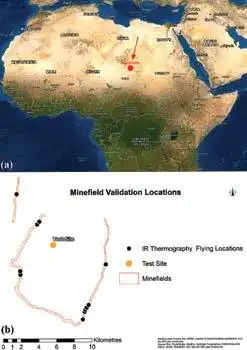
Figure 3(a). The arrow and red marker show the location of the minefields where work took place in the Sahara Desert, 280 km south of the Libyan border with Chad. 3(b) The minefield perimeter area and ten different flying, field validation locations. Also the location of the test site, within a 10 km radius of active, in-situ legacy minefields.
In October 2019, most flights over minefields started before 4:00 a.m. and continued until sunrise. Flying at night was preferred during the colder March 2020 period, an hour after sunset, until 10:00 p.m. This was because variability in seasonal conditions seemed to determine when anomalies would appear strongest to the thermal cameras.
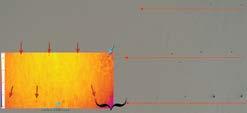
Figure 4. Above shows an example of ground-truthing or visual validation from outside of the minefields. A thermal/LWIR image from the small drone is joined to a high-resolution daylight image. The same pattern continues in mine rows (a) and (b), after surface landmines are no longer seen from mine rows (ii) and (iii). Sub-surface anomalies maintained the same horizontal spacing and object size as for landmines exposed on the surface (from erosion). With high-resolution, smalldrone daylight imagery, we could identify the type and model of each mine on the surface in mine rows (i)–(iii). This taught us how to interpret thermal anomaly signatures and identify specific local patterns then progress in finding anomalies from buried mine rows without the need for patterns on the surface as a starting point.
Data was captured from ten different legacy minefield locations to cover a variety of natural conditions and landmine types. Several of these locations were revisited at different times of the day and night during both seasons.
A form of minefield ground-truthing methodology was developed using visual and thermal/LWIR imagery together. Mine rows were laid using traditional military tactics and often appeared in linear patterns. To validate that anomalies were from landmines, researchers flew drones over locations where rows of surface mines were visible from erosion and then directed the drone flight left or right along that line, where buried landmines were not visible to the naked eye. This method provided confidence that anomalies captured in thermal/ LWIR data represented buried landmines (Figure 4). Mine row patterns were followed by flying along thermal anomalies using a scouting methodology (following the anomaly dots in real time) to make judgement calls regarding the extent of contamination and where minefield borders may be located. MAG (Mines Advisory Group) also provided researchers with data from past clearance operations, which noted the models of landmines found in the area and how they were laid in patterns, at set distances from each other.
CONTROLLED FIELD TESTING
A grid of 80 x 80 cm boxes was established at the field test site, where production landmines, landmines free from explosives (FFE), and a range of different simulant designs were buried for comparison.
A thermal/LWIR camera7 was mounted on a 7-meter-high mast, with a field of view of sixty-six boxes, which captured images every minute. Thermocouple probes with data loggers that captured information at two-minute intervals were buried at different depths above, away from, attached to, and inserted inside landmines.
EQUIPMENT AND SOFTWARE
Commercially available equipment and sensors were utilized. A DJI FLIR Zenmuse XT8 thermal/LWIR camera with a 13 mm lens, 640 x 512 pixel resolution, and radiometric data capture capabilities was attached to the drone. An additional thermal/LWIR camera/sensor with almost identical capabilities, the FLIR Duo Pro R,7 was also purchased for the controlled test site. The small drone used was an industrial (not consumer) model: an off-the-shelf DJI Matrice M210 v2 quadcopter9 (Image 3). The same software and similar procedures were utilized for data processing and storage as those for visual imagery.1
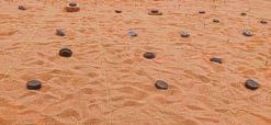
Image 2. Setting up the controlled field test site to bury: production, FFE, and simulant landmines from where IR thermography data was automatically captured at one-minute intervals, 24-hours a day.
Characterizing Thermal Anomalies. The sand surface was noisier during the day from the effect of sunshine when anomalies from buried landmines were warmer than the surrounding sand. Hence, colder thermal anomalies are presented in airborne IR thermography data captured at night.
Different in-situ signatures were recorded via drone-mounted thermal cameras for the three main types of landmines present. At night, each produced a cooler buried anomaly, with the PPM-2 and PRBM3A1 appearing warmer than the sand when exposed to the surface. However, the PMA-3 was cooler than the surrounding sand when exposed to the surface (Figure 2, Figure 4).
The cylindrical pressure plate (PP) of the PRB-M3A1 displayed different thermal characteristics than its square plastic body containing 6 kg of explosives. The PP was colder than the body area when buried but warmer than surrounding sand if very close to the surface or partially exposed (Figure 5, Figure 6).
Natural objects such as stones and manmade objects did not create too much noise in competing with anomaly signatures from buried landmines (Figure 9). Airborne IR thermography was effective in also locating secondary indicators, such as metal posts which were internal
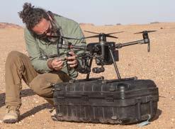
Image 3. Fieldwork at remote, in-situ Sahara Desert minefields using a small industrial model, off-the-shelf, DJI Matrice M210 v2 quadcopter with advanced sensors.
RESULTS
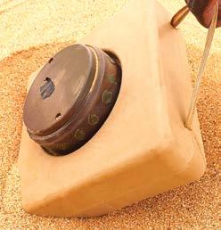
Image 4. The PRB-M3A1 landmine, which showed different thermal anomaly characteristics from the pressure plate than the square plastic body filled with 6 kilograms of explosives.
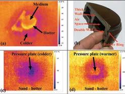
Figure 5. Small drone flying data showing thermal signature characteristics of a PRB-M3A1 AV landmine (Image 4). Thermal characteristics of an in-situ partially buried PRB-M3A1 can be seen in (a). At night, a ring around the pressure plate is hotter when interfacing with the air. See (b) for a cross section of a pressure plate to understand why. In (a), parts of the plastic body exposed to the air are warmer, and sections of the body interacting with the sand, including 6 kilograms explosives are cooler. Different thermal anomalies from another two buried insitu PRB-M3A1 landmines are shown in (c) and (d), where (c) is deeper because the pressure plate anomaly is colder than for the square body of the landmine, and (d) is shallower and very close to the surface as the pressure plate anomaly is warmer than from the body. However, (d) is not exposed very much because a hotter ring around pressure plate like (a) would be evident if interacting with the air.
Optimal Flying Height. Data was captured from heights of 3 m (Figure 5) above ground level (AGL) to 100 m AGL. The maximum effective range at which these anomalies could be identified was from a flying height of 80 meters AGL for buried PRB-M3A1 anti-tank landmines, and at 30–35 m AGL for PMA-3 anti-personnel landmines. Greater efficiency is gained by flying higher because a larger footprint is captured in each image and the drone can fly faster, covering more ground per unit of energy. Figure 7 shows anomalies from nine buried landmines in a footprint captured from the sensor at 20 m AGL, compared to Figure 1 showing twenty-seven anomalies in a footprint captured by the sensor at 35 m AGL. A more extreme example can be seen in Figure 8 at a height of 55 m AGL. Twenty-four anti-tank landmine anomalies appear across the top and bottom rows. From the pattern in that location, we know that there are two anti-personnel mine rows in the middle with similar spacing. Hence it is not unreasonable to infer that around forty-eight anomalies exist in this thermal/LWIR image.
Optimal flying heights would need to be reviewed by season or perhaps on individual days according to the strength of anomalies.
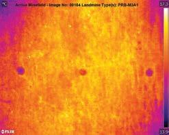
Figure 6. Proof that the tool works. Above is an airborne thermal/LWIR image of anomalies from a height of 10 m AGL. This indicates the location of three buried in-situ PRB-M3A1 anti-tank landmines. Close examination will show different thermal responses from cylindrical pressure plates in the middle of each anomaly. This is different to how the square plastic body containing 6 kg of explosives reacts with the environment.
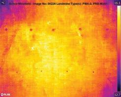
Figure 7. The thermal/LWIR image above was captured over active, legacy minefields from a height of 20 m AGL. Anomalies from five PRB-M3A1 anti-tank landmines can be seen at the top, and four PMA-3 anti-personnel landmine anomalies at the bottom. Nine landmines are in this footprint.
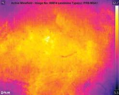
Figure 8. Above, a thermal/LWIR image from a height of 55 m AGL. It is too high to see the anti-personnel landmine thermal anomalies in the middle two rows but enough resolution exists to see twelve anti-tank anomalies in each of the top and bottom rows. Assuming a similar number of anti-personnel landmines exist in the two middle rows, that makes around forty-eight anomalies in this thermal/LWIR image. It provides a good idea regarding where the edges of mine row borders are located.
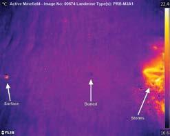
Figure 9. above is an example of how stones appear from airborne in-situ thermal/LWIR data. In this case, surface and buried landmines could still be identified at night.
Controlled Field Testing. The controlled field test site captured quantitative data regarding the impact of a diurnal cycle, weather, and the local environment. One of our main objectives was to determine which times to fly the small drone. The following are some of the highlights based on a reference PMA-3 anti-personnel landmine (Image 5). The reference landmine provided a trackable benchmark over time to provide observable differences that weather and environmental variables made on anomaly signatures captured by the thermal/LIWR camera. It also provided a benchmark to compare against anomalies from other landmine models and simulants buried at different depths.
Optimal Timeframe. Table 1 is a summary of anomaly strengths captured by the thermal/LWIR cameras over eleven different time slots during more than four 24-hour diurnal cycles. Captured under actual field conditions, the fifty-two data points presented in Table 1 take into account every single variable at the time. Sunrise was at around 6:00 a.m., with sunset at around 5:30 p.m. The test site data in Table 1, Figure 10, and Figure 11 confirmed that a 2.5-hour period pre-dawn and up to 4 hours post-dusk were the best operating times, meaning night was the optimal time to search for anomalies.
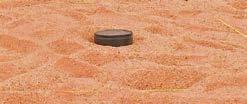
Image 5. Our reference PMA-3 anti-personnel landmine was buried at a depth of 1 cm. It is shown above after excavation at the end of the study. The type of sandy environment can also be seen.
Influence of the Clouds, Sun, and Wind. Cloud cover seemed to reduce how noisy the sand surface appeared to the sensor during the day, likely because of diffused reflectance from the sun. Data in Figure 12 from 9:00 a.m. on Day 3 and 9:00 a.m. on Day 6 indicates that the anomony from the reference landmine is noisier on a sunny day compared to a cloudy day. However, there was more wind on the sunny day, which could have a combined effect.
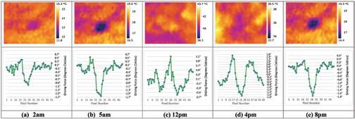
Figure 10. Above is data showing thermal anomalies during different times of the day and night (diurnal cycle) from Day 2 (Table 1) of our PMA-3 reference landmine. Thermal anomalies at night: pre-dawn at 5:00 a.m. (b) and post dusk at 8:00 p.m. (e) are stronger and clearer, which supports findings in Table 1 and Figure 11 that a few hours pre-dawn and post-dusk are the best operating times. Anomalies captured by the test site sensor at 2:00 a.m. (a), 12:00 p.m. (c) and 4:00 p.m. (d) are weaker and not very clear. Graphs show a surface cross section of the difference in temperature between the anomaly, and plain sand around it (driving force).

Figure 11. Above is test site data showing the impact of wind: using anomalies captured from the PMA-3 reference landmine, as an example at 10:00 p.m. each night over five consecutive nights. Conditions were calm on Days 1 and 2, with the wind picking up at 12:00 p.m. on Day 3 and dropping off at 8:00 p.m. on Day 5 (Table 1, Figure 10). Hence, it was calm on the first, second, and fifth nights (a), (b), and (e), but windy during the third and fourth nights (c) and (d). The data shows that the strength of the anomaly was affected by the wind, with the clarity of the anomaly captured by the sensor dropping or disappearing at windy times. This proves that the viability of such a potential new tool can vary by day, depending on the local weather and environmental conditions. Graphs show a surface cross section of the difference in temperature between the anomaly, and plain sand around it (driving force).
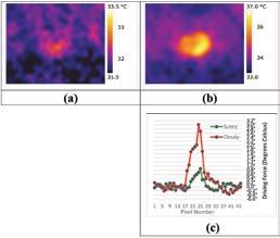
Figure 12. Anomalies from our PMA-3 reference landmine at 9:00 a.m. when it was sunny (a) and cloudy (b). Numbers in the driving force graph (c) look better for (a) than the image suggests, as data seemed noisiest when it was sunny. There was also a combination of less wind, plus clouds in (b), meaning compounded variables.
We found that the wind had an impact on the strength of thermal anomalies from buried landmines captured by the sensor. Figure 11 shows more detailed examples from the Table 1 summary, quantifying the strength of the thermal anomaly captured from our reference PMA-3 antipersonnel landmine at 10:00 p.m. each night, over five nights. The anomaly was clearly visible during calm times but was weak or not visible to the sensor when the wind increased (Figure 11). Table 1 shows the anomaly strength over many other time slots, with variability being affected by the wind on Days 4 and 5.
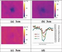
Figure 13. Above is test site anomaly data from three different PMA-3 AP landmines buried at 1 cm (a), 3 cm (b), and 5 cm (c) depths during one of the better nights. (d) graphs the strength of each of (a)-(c) anomalies compared to sand’s natural surface temperature.
Impact of Depth. Figure 13 shows that the strength of anomalies reduces by landmine burial depth. The 3-cm-deep anomaly can be seen in the raw thermal/LWIR image but the anomaly from a 5 cm depth cannot be seen in the original thermal/LWIR image. A weak anomaly from the 5 cm depth can be seen in data exported in Figure 13(d), which might be improved with post-processing.
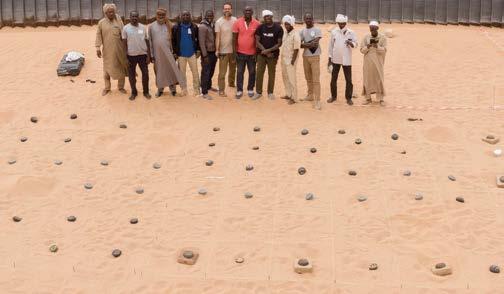
Image 6. Camping and working at night in the desert, surrounded by minefields is not an easy feat. At least ten skilled HMA personnel were required to support each campaign in the field and to ensure safety.
Overall, landmines at in-situ legacy minefield locations seemed to create more significant anomalies than the test site, which could be intensified after a much longer settling time in the ground and if an optimal amount of moisture had built up. More fieldwork data, ideally including simultaneous in-situ excavation at legacy minefields (covering every variable) is required for better estimates of the maximum viable depth.
DISCUSSION
The emphasis of this article is to prove how small drone IR thermography was an effective HMA tool in the Sahara Desert, northern Chad. Data collection and validation occurred under actual field conditions, in one of the most extreme environments on the planet—working in confirmed hazardous areas (CHAs), in a red zone, with the challenges of camping and operating reliably in extreme conditions, in between sandstorms, offline, at night, and with minimal infrastructure. At least ten skilled HMA personnel were required to support each campaign in the remote locations visited, and to ensure operational safety.
We have shown evidence of how anomalies from anti-personnel and anti-tank landmines captured using IR thermography from a small drone at legacy minefields can be used as an effective survey technique to estimate the location of such buried objects. Proof can be seen in ten examples of airborne thermal/LWIR data: Figures 1, 2, and 4–9.
We have shown that performance-affecting factors are flying height, physical properties of individual landmines, diurnal elements, burial depth, the sun, the wind, and possibly cloud cover. Ground water content and moisture are variables to consider in the future. Anecdotally, seasonal differences (hot vs. cooler season) appeared to make a difference. We suspect that temperature is the driving force causing this, so the time of the year with the greatest differences between day and night temperatures is most likely to give the greatest visualization.
We have shown that in the field, multiple environmental and weather parameters are at play, each with different traits. Variability in weather conditions can affect an individual site by day. We found that highresolution off-the-shelf sensors7,8 were effective in capturing thermal anomalies from buried landmines. A micro drone with an integrated lower-resolution thermal sensor10 was tested and found to be inadequate.
We have summarized findings to suggest that optimal operating times at locations in the Sahara Desert are at night. During optimal operating times, anomalies from buried landmines at locations visited in northern Chad were quite clear and did not require post-processing or deep-learning techniques for data to be useful. More information is required, ideally including simultaneous excavation at legacy in-situ minefields to determine the maximum landmine burial depth at which thermal anomalies can be identified.
A review of existing knowledge regarding IR thermography for locating buried landmines was made, ascertaining what was considered to be state-of-the-art. Our applied research built upon this to generate a new state-of-the-art in thermal/LWIR knowledge, which is hoped to become an initial starting point for future researchers. Mobility Robotics and HI learned practical lessons, with additional datasets in hand that will enable more specialized studies, extending beyond the scope of this introductory article.
We have visualized fifteen different anomalies in Figures 6-13 and analyzed fifty-two different anomalies in Table 1 from production landmines buried at our field test site. We have seen that thermal anomaly signatures can vary by each model of production landmine located at in-situ, legacy minefields, meaning that generalizations may not be accurate. We have also learned how to interpret nuances associated with each anomaly.
Lessons from the field suggest a weakness in general knowledge regarding landmine materials analysis from a thermographic perspective, particularly regarding the impact of materials such as rubber coatings and mechanical construction differences. Past work requires updating in the area of landmine simulant design.11–14 The use of airborne IR thermography could be extended to locate buried unexploded ordnance (UXO) and explosive remnants of war (ERW), utilizing the same test site methodology to verify optimal operating parameters by depth, object properties, diurnal cycle, environmental, and weather conditions. Such methodology could also be adapted for use in other sectors, such as archaeology, to define optimal operating parameters in finding buried objects.
CONCLUSIONS
This project proved that airborne IR thermography can be used to locate buried landmines from small drones in Sahara Desert minefields. We found that the strength of thermal anomalies can vary by day, indicating that generalizations cannot be made without more field data to substantiate claims. Ideally, this would be undertaken across many arid and semi-arid locations in different countries contaminated with landmines. Regarding IR thermography research for HMA in general, the first, second, and third priorities should be more data collection under actual field conditions either at or within a close proximity to legacy minefields.
Based on lessons learned from mapping more than 30 linear km from small drones with regular daylight cameras in the same region, IR thermography is not the only option. It can be a less effective tool in some circumstances such as in mapping surface landmines in an arid environment.
FUTURE WORK
Priority areas regarding future work include different opportunities:
1. Dissemination, advocacy, and greater analysis to capitalize on the tens of thousands of data points captured and help the HMA sector gain confidence in such a tool; and
2. Leveraging new, state-of-the-art knowledge in IR thermography as a launch pad for real-world trials in other locations.
Opportunities regarding automated data processing such as deep learning and machine vision will also be investigated in order to leverage the impact of data in-hand from legacy minefields. Real-world minefield data is required to train algorithms with accurate thermal/ LWIR anomalies from specific models of production landmines, captured under local environmental and weather conditions. A lack of accurate real-world training data is currently a limiting factor for automated data processing research.
Ideally, a range of HMA actors joining the research effort to accelerate momentum in moving the needle even further would substantially benefit the field’s knowledge of thermal/LWIR techniques for HMA, as duplicative work will only delay gains in community expertise. Additional follow-on articles could be authored to leverage the impact of an unprecedented amount of field data captured in Chad. Themes include 1. a more technical discussion of the underlying science and more granular anomaly analysis, comparing theory and reality in more detail; 2. a step-by-step guide on how to set up a controlled field test site to determine the feasibility of IR thermography for locating buried landmines, ERW, and other objects in each region; 3. a more detailed review of individual variables: natural, weather, object materials, diurnal cycle and geophysical elements from an extensive amount of data in-hand; 4. theory and reality in simulant and surrogate landmine design: based on real-world thermal anomaly signatures from the field; and 5. sharing lessons learned regarding risk-mitigation and operating procedures, e.g., extreme fieldwork conditions, and reliably operating small drones at minefields at night.
If funding, logistics, and permissions can be secured, an ideal supplementary project to accelerate momentum in moving the needle even further would be to develop a standard field test kit and establish controlled test sites in arid and semi-arid environments with a range of HMA partners in many other regions. For more information, including flying videos and sample data see www.mr-au.com/chad.
See endnotes, charts, and tables in complete edition of Issue 24.2
ACKNOWLEDGEMENTS
The Odyssey2025 Project ran from October 2018 until March 2020 with the small drone components of the project recently being awarded a €1,000,000 EIC Horizon (Horizon 2020) Affordable High-Tech for Humanitarian Aid innovation prize from the European Commission. We would like to thank a number of people and organizations who made the project possible, including our donor, the Belgian Directorate-General Development. In addition, we owe special thanks to the people of the HCND who made real-world testing and access to production landmines possible including the Coordinator, General Djibrine Brahim and the Director of the Regional Center for Demining - Fada, Sougou Ardi Kellemi. We would also like to thank the Geneva International Centre for Humanitarian Demining (GICHD) and the Swiss Foundation for Mine Action (FSD) for joining the technical steering committee for the Odyssey2025 Project, as well as the following people for their contributions and assistance: Seydou Gaye, Jadot Bamungu, Jason Mudingay, Gary Toombs, Luc Lampriere, HI staff in Belgium and Lyon, the MAG, FSD, and OCHA teams in Chad, HI/PRODECO personnel in Chad, particularly Marie-Cécile Tournier and Jean-Michel Mathiam in helping to address gargantuan logistical challenges, and our advisers from Australia: Scott Willan, Jackie Dujmovic, Louise Shewan, and Prof. Pablo J. Zarco-Tejada.
Pierre Gallien is an agronomist with complementary training in management, epidemiology, and strategic foresight. During his twenty-five-years’ of experience in the humanitarian field, he has held many technical (technical coordinator, Head of Knowledge Management division) and operational (geographical manager, mission director) positions for Action Against Hunger, Solidarités International, and HI.
John Fardoulis is a scientist, remote-sensing practitioner, and aerospace engineer specializing in methodology design, field deployment, capacity building, and applied research into the use of small drones for humanitarian purposes in hazardous environments. He was the small drone specialist on the HI Odyssey2025 Project in Chad. Fardoulis has a bachelor of business from the University of Western Sydney and a MSc in Aerospace Engineering from the University of Bristol.
Xavier Depreytere joined Humanity & Inclusion (HI) in 2018 after working in the industry as an automation project engineer. He was in charge of the strategy and coordination of the HI Odyssey2025 Project in Chad. Depreytere holds a masters in biosystems engineering from the University of Mons, Belgium.
Following a master’s degree in international relations and crisis management from the Institut d’Etudes Politiques de Toulouse (2018), Djouhri has held various positions at HI to date. Based in Ndjamena, Chad, Djouhri was the project manager for the HI Odyssey2025 Project, working with national authorities to ensure the successful execution of the project.
Ba Abdourahmane holds a bachelor’s degree in sociology and began working in humanitarian mine action in 2012 with international organizations such as Norwegian People’s Aid (NPA) and Denel MECHEM before beginning with HI in 2015 in Casamance. Abdourahmane was the expedition leader and Chief of Operations in the field during desert airborne IR thermography campaigns in Chad.
Emmanuel Sauvage has an industrial logistics management background and began working in humanitarian action in 1994 in the former Yugoslavia. He first joined HI in 2002. For the past seventeen years, Sauvage has held senior and advisory positions for HI and other international organizations/agencies in the field of humanitarian mine action and armed violence reduction. He has had direct exposure to information management, QA/QC, land release (clearance and surveys), risk education/management, and victim assistance and advocacy.


