Plan Orinda Final Environmental Impact Report/ Responses to Comments on the Draft EIR SCH#2022010392 prepared by City of Orinda Planning Department 22 Orinda Way Orinda, California 94563 Contact: Winnie Mui, Associate Planner prepared with the assistance of Rincon Consultants, Inc. 449
Street, Suite 303
California 94612 January 2023
15th
Oakland,
Table of Contents Final Environmental Impact Report/ Responses to Comments on the Draft EIR i Table of Contents Acronyms and Abbreviations iii 1 Introduction ....................................................................................................................................1 1.1 Purpose of the Response to Comments on the Draft EIR 1 1.2 Environmental Review Process 1 1.3 Document Organization ......................................................................................................1 1.4 General Introduction...........................................................................................................2 2 Verbal Comments and Responses 3 3 Written Comments and Responses ................................................................................................5 4 Revisions to the Draft EIR 76 5 Recirculation Not Warranted........................................................................................................84 6 References 86 Appendices Appendix TRA-REV Revised Transportation Analysis
This page intentionally left blank.
Plan
ii
City of Orinda
Orinda
Acronyms and Abbreviations
AB Assembly Bill
BART Bay Area Rapid Transit
Caltrans California Department of Transportation
CCTA Contra Costa Transportation Authority
CDFW California Department of Fish and Wildlife
CEQA California Environmental Quality Act
CESA California Endangered Species Act
CFGC California Fish and Game Code
CNDBB California Natural Diversity Database
DPP Downtown Precise Plan
EBMUD East Bay Municipal Utility District
EIR Environmental Impact Report
HCD California Department of Housing and Community Development
NOP Notice of Preparation
OPR Office of Planning and Research
RTC Response to Comments
SSTOC Supplemental Sales Tax Oversight Commission
VMT Vehicle Miles Traveled
Acronyms and Abbreviations Final
iii
Environmental Impact Report/ Responses to Comments on the Draft EIR
This page intentionally left blank.
Plan
iv
City of Orinda
Orinda
1 Introduction
1.1 Purpose of the Response to Comments on the Draft EIR
This document contains responses to comments received on the Draft Environmental Impact Report (Draft EIR) prepared for Plan Orinda (project). The Draft EIR identifies the likely environmental consequences associated with development facilitated by the proposed project and recommends mitigation measures to reduce potentially significant impacts. This document, together with the Draft EIR, constitutes the Final EIR for the proposed project.
1.2 Environmental Review Process
Pursuant to the California Environmental Quality Act (CEQA), lead agencies are required to consult with public agencies having jurisdiction over a proposed project and to provide the general public with an opportunity to comment on the Draft EIR.
The City of Orinda distributed a Notice of Preparation (NOP) of the Program EIR for a 51-day agency and public review period commencing January 4, 2022. The NOP was amended on January 15, 2022 and public comment closed on February 24, 2022. In addition, the City held a virtual Scoping Meeting on January 20, 2022. The meeting was aimed at providing information about the proposed project to members of public agencies, interested stakeholders and residents/community members, and at receiving comments on the scope and content of the EIR. Due to the COVID-19 pandemic, the meeting was held virtually, through an online meeting platform and a call-in number.
The Draft EIR was made available for public review for a 46-day comment period that began on September 15, 2022 and ended on October 31, 2022. The Notice of Availability of a Draft EIR was posted with the County Clerk, sent to the State Clearinghouse, and posted on the City’s website. The City received verbal comments on the Draft EIR during the virtual Downtown Subcommittee meeting on October 3, 2022.
The City received written comment letters on the Draft EIR from three agencies and three individual commenters. Copies of written comments are included in Chapter 3 of this document.
1.3 Document Organization
This document consists of the following chapters:
Chapter 1: Introduction. This chapter discusses the purpose and organization of this response to comments Document and the Final EIR and summarizes the environmental review process for the project.
Chapter 2: Verbal Comments and Responses. This chapter includes responses to verbal comments received at the Downtown Subcommittee meeting held virtually on October 3, 2022.
Chapter 3. Written Comments and Responses. This chapter contains reproductions of the comment letters received on the Draft EIR during the public comment period. A written response for each CEQA-related written comment is provided, and each response is keyed to the corresponding comment.
City of
Plan Orinda Introduction
Orinda
Final Environmental Impact Report/ Responses to Comments on the Draft EIR
1
Chapter 4: Revisions to the Draft EIR. Revisions to the Draft EIR that have been made are contained in this chapter.
Chapter 5: Recirculation not Warranted. Discussion of why minor changes made to the Draft EIR do not warrant recirculation of the Draft EIR under CEQA
1.4 General Introduction
As a general introduction, it should be noted that the conclusions on the significance level of environmental impacts are supported by substantial evidence, which is presented in the Draft EIR and further clarified in this Final EIR (specifically Sections 2, 3, and 4, which provide responses to comments received on the Draft EIR). The City acknowledges that some commenters disagree with some conclusions in the Draft EIR. Consistent with the intent of CEQA and the CEQA Guidelines for its implementation, this Final EIR also includes the differing opinions presented by the commenters. As stated in the CEQA Guidelines Section 15151, disagreement among commenters, including experts, does not make an EIR inadequate, but the EIR should summarize the main points of disagreement among the experts; this is done in this Final EIR. Pursuant to CEQA, comments on the project itself or topics other than the Draft EIR do not require a response. This Response to Comments (RTC) document provides responses to comments on the Draft EIR and identifies text revisions to the Draft EIR, as necessary, in response to those comments or to clarify, amplify, or make insignificant modifications to the text of the Draft EIR (CEQA Guidelines Section 15088.5(b)).
In addition to receiving comments on the Draft EIR, the City also received comments on the Housing Element Update, including comments from the State Department of Housing and Community Development (HCD). In response to these comments, as well as feedback from the public and decisionmakers, the City revised the Housing Element Update. A new version of that document was published on January 5, 2023. These revisions primarily involved (1) designating additional DPP sites as “Housing Element Sites”; (2) removing several sites in the DPP from the Housing Element Update; and (3) increasing the allowable densities on DPP sites above what was previously described in the Housing Element Update, but within the range of densities analyzed in the Draft EIR. See Response to Verbal Comment 1: Maximum Buildout Variations between EIR and Housing Element Update. Because potential development of these DPP sites was already analyzed in the Draft EIR at densities equal to or greater than those described in the revised Housing Element Update, no revisions to the Draft EIR were required as a result of the revisions to the Housing Element Update and these revisions would not affect the environmental analysis
Final Environmental Impact Report/ Responses to Comments on the Draft EIR
City
Plan Orinda Introduction
of Orinda
2
2 Verbal Comments and Responses
This Chapter presents responses to comments that were made at the Downtown Subcommittee Meeting on October 3, 2022.
Response to Verbal Comment 1: Maximum Buildout Variations between EIR and Housing Element Update
Commenters requested clarification about the difference between maximum buildout analyzed in the Housing Element compared to maximum buildout evaluated in the EIR.
As stated on Page 2-8 of Section 2, Project Description, after the Draft Housing Element was released for public review in March 2022, it was revised to remove the St. Stephen’s church site (66 St. Stephens Drive), the Sleepy Hollow site (APN 266-220-036), and the East Bay Municipal Utility District Bear Creek Road site (APN 266-220-029) from the sites inventory. As such, those sites were not included in the EIR analysis.
Further, the City’s Housing Element is prepared for approval by the California Department of Housing and Community Development (HCD) In 2017, AB 1397 amended the State Housing Element Law which required cities to account for the probability of development of non-vacant sites in their housing elements rather than assuming all sites would be developed to the maximum extent possible. AB 1397 does not alter environmental review under CEQA and, as such, the EIR analysis assumes maximum buildout while the Housing Element does not. The EIR analysis is conservative as it assumes that every probable unit and site would be developed. The requirements for each document differ and, therefore, the documents have different numbers for maximum buildout.
Response to Verbal Comment 2: Density Bonus
Commenters asked whether the potential for projects to apply for a density bonus was factored into the EIR analysis and whether projects would be exempt from further analysis at the project-specific level if they used the density bonus.
Future residential projects may use provisions of the State Density Bonus law (California Government Code Sections 65915 – 65918) to develop affordable and senior housing, including up to a 50 percent increase in project density, depending on the amount of affordable housing provided, and up to an 80 percent increase in density for certain projects which are 100 percent affordable. The State Density Bonus law also includes incentives to make the development of affordable and senior housing economically feasible. These include waivers and concessions, such as reduced setback, height or minimum square footage requirements.
Whether an individual project would use the State Density Bonus law, or which waivers or concessions would be requested, is difficult to predict. The EIR assumed maximum development standards such as building height and residential density. The buildout assumptions included in the Draft EIR are conservative and they likely account for a reasonably foreseeable number of density bonus units, and thus could include more units than would likely be built under the City’s development standards alone (i.e., without the use of a density bonus). However, assuming use of the State Density Bonus law would be speculative, as it is not possible to predict which projects on which sites would use which waivers or concessions and how much density bonus would be requested (CEQA Guidelines Section 15145).
City of Orinda Plan Orinda Verbal Comments and Responses Final Environmental Impact Report/ Responses to Comments on the Draft EIR
3
If projects facilitated by the Housing Element Update use the State Density Bonus, they may be subject to further project specific environmental review under CEQA. The level of environmental review necessary may vary and would be determined once a project application has been submitted to the City. No additional analysis is warranted or appropriate at this programmatic stage.
Response to Verbal Comment 3: Transportation Analysis and Distance to Schools
Commenters asked how transportation analysis was done and if it factored in the increased commute to schools that are outside of the main downtown area in Orinda.
The transportation analysis used the Contra Costa Transportation Authority’s (CCTA) vehicle miles travelled (VMT) model and incorporates the project’s trips to and from schools in Orinda. Each of the traffic analysis zone land uses in the CCTA’s model includes student enrollment, which is then used to model school trips. In addition, parents of elementary school students that attend Sleepy Hollow Elementary, Wagner Ranch Elementary, Glorietta Elementary, or Del Rey Elementary have the option of buying school bus passes for students to be picked up and/or dropped off at designated pick up/drop off zones throughout the LaMorinda area which would further reduce VMT related to school trips. The main drop off/pick up point for school buses in Orinda is centrally located in the Downtown Precise Plan (DPP) area.
Response to Verbal Comment 4: Preservation of Commercial Space in the DPP
Commenters expressed concerns over how commercial space would be preserved with the proposed zoning changes in the DPP that allow for mixed and residential uses in Downtown Commercial and Downtown Office zoning designations.
The EIR assumed no change in commercial square footage in the DPP area. Plan Orinda would include proposed zoning changes, as described in Section 2, Project Description, these changes would allow for residential and mixed uses in Downtown Commercial and Downtown Office Zones. Residential development in these zones is expected to be above, beside, or on underutilized portions of current commercial sites in the DPP as commercial square footage would not be expected to change and therefore Plan Orinda would not substantially reduce commercial square footage or usage.
Final Environmental Impact Report/ Responses to Comments on the Draft EIR
City of Orinda Plan Orinda Verbal Comments and Responses
4
3 Written Comments and Responses
This chapter includes written comments received during the 46-day public comment period on the Draft EIR, and responses to those comments. The City of Orinda received six comment letters on the Draft EIR. The commenters and the page number on which each commenter’s letter appear are listed in Table 1 below.
Table 1
Comment Letters Received
Number Commenter
Public Agencies
A1
Affiliation
East Bay Municipal Utility District (EBMUD)
A2 Erin Chappell, Regional Manager-Bay Delta Region California Department of Fish and Wildlife (CDFW)
Date Received Page Number
October 27, 2022 6
October 31, 2022 12
A3 Mark Leong, District Branch Chief California Department of Transportation (Caltrans) October 31, 2022 32
Individuals
P1 Owen Murphy Public September 26, 2022 39
P2 Michele Jacobson Public September 30,2022 42
P3 Nick Waranoff Public October 3, 2022 50
The comment letters and responses follow. The comment letters have been assigned a unique abbreviation and each separate issue raised by the commenter, if more than one, has been assigned a number. The responses to each comment identify first the abbreviation given to the comment letter, and then the number assigned to each issue. For example, the first East Bay Municipal Utility District (EBMUD) letter is labelled Letter A1. Comments from that letter are numbered Response A11, A1-2, A1-3, etc. in the order they appear in the letter.
In some cases, specific changes to the text of the Draft EIR have been made in response to comments received. In no case do these revisions result in a greater number of impacts or impacts of a substantially greater severity than those set forth in the Draft EIR. Where revisions to the Draft EIR text are called for, the page and paragraph are set forth, followed by the appropriate revision. Added text is indicated with underlined and deleted text is indicated with strikeout. Page numbers correspond to the page numbers of the Draft EIR.
City of Orinda Plan Orinda Written Comments and Responses Final Environmental Impact Report/ Responses to Comments on the Draft EIR
David J. Rehnstrom, Manager of Water Distribution Planning
5
From: McGowan, Timothy
To: PlanOrindaEIR
Subject: Draft Environmental Impact Report for Plan Orinda
Date: Thursday, October 27, 2022 11:11:09 AM
Attachments: sb22_320 Plan Orinda - signed.pdf

CAUTION: This email is from an external source. Be careful when clicking links or opening attachments!
Please see the attached letter regarding the Draft Environmental Impact Report for Plan Orinda.
Thank you, Timothy McGowan
Senior Civil Engineer Water Distribution Planning Division 510-287-1981 | timothy.mcgowan@ebmud.com
Letter A1 6
1.1 1.2 1.3 1.4 1.5 1.6

7
8
1.6
9
1.6 1.7
Letter A1
COMMENTER: David J. Rehnstrom, Manager of Water Distribution Planning, East Bay Municipal Utility District (EBMUD)
DATE: October 27, 2022
Response A1.1
The commenter requests that “Siesta Valley Recreation Area” be replaced with “Siesta Valley watershed sub-basin” in Section 3.1 and Section 4.3.1 of the EIR.
In response to this comment the following changes were made to the Draft EIR:
Section 3, Page 3-1:
The city is in a valley surrounded by rolling hills with mature trees. Surrounding open space areas contribute to this semi-rural character including: Briones Regional Park is situated northeast and Tilden Regional Park, the Siesta Valley watershed sub-basin Recreation Area, and Sibley Volcanic Regional Preserve are northwest, west, and southwest of the city, respectively.
Section 4.3, Page 4.3-1:
To the south, Orinda is bounded by the East Bay Municipal Utility District (EBMUD) Siesta Valley watershed sub-basin Recreation Area, and to the north lies the EBMUD San Pablo and Briones Reservoirs. The City is primarily developed with residential and commercial uses, although it includes some areas of natural open space.
Response A1.2
The commenter requests that watershed be included as an existing EBMUD land use in Section 4.7.1.a of the EIR
In response to this comment the following changes were made to the Draft EIR:
Section 4.7, Page 4.7-1
Existing land uses in the City consist of a variety of primarily single-family residential, the Downtown (consisting of commercial, office, institutional, and multi-family residential), and open space, watershed, and utility land holdings (East Bay Municipal Utility District and Pacific Gas and Electric Company).
Response A1.3
The commenter requests that “Siesta Valley Recreation Area” be replaced with “Siesta Valley watershed sub-basin” and the description “which is a 29,000 acre park” be removed in Section 4.10.1.e. Additionally the commenter requests that reference to Lamorinda Trail and picnic areas be removed in the same section.
In response to this comment the following changes were made to the Draft EIR:
Section 4.10, Page 4.10-5
East Bay Municipal Utility District (EBMUD) owns Wagner Ranch, and manages the Siesta Valley watershed sub-basin Recreation Area, which is a 29,000-acre park adjacent to downtown Orinda that includes hiking trails, such as the De Laveaga Trail and Lamorinda Trail, a seasonal open-air
Plan
Written Comments and
City of Orinda
Orinda
Responses Final Environmental Impact Report/ Responses to Comments on the Draft EIR
10
City of Orinda Plan Orinda Written Comments and Responses
theatre (Cal Shakes), and picnic areas. The De Laveaga Trailhead is located on Camino Pablo Road near the intersection with Santa Maria Way along the western edge of downtown Orinda. The Lamorinda Trail can be entered along Moraga Way, Bryant Way, Davis Road, or from the Orinda BART station, and connects Orinda, Moraga, and Lafayette. While Wagner Ranch is owned by EMBUD, OUSD manages a nature area adjacent to Wagner Ranch Elementary School.
Response A1.4
The commenter requests that “Laveaga Trail” be replaced with “De Laveaga Trail” in Section 4.11.1.b.
In response to this comment the following changes were made to the Draft EIR: Section 4.11, Page 4.11-9
Village Grove – Siesta Valley Trail: Work with EBMUD to explore the construction of a trail from the Gateway Boulevard/SR 24 ramp to the De Laveaga Trail.
Response A1.6
The commenter explains that water service for new multiunit structures must be individually metered or submetered to encourage water conservation. The commenter also explains that main extensions, pipeline and fire relocations and replacements and off-site pipeline improvements will be made at the project sponsor’s expense for future development under Plan Orinda. The commenter also explains the conditions under which EBMUD will now install piping or services.
Although this comment does not pertain to the analysis or conclusions of the EIR, the comment is noted by City staff and will be forwarded to the decision makers.
Response A1.7
The commenter requests that the City include in its conditions of approval a requirement that project sponsors must comply with Assembly Bill 325 “Model Water Efficient Landscape Ordinance.”
Development projects facilitated by the Housing Element Update would be required to comply with Assembly Bill 325 pursuant to the CalGreen Building Code, and the City would review and approve projects for compliance prior to issuance of building permits.
Final Environmental Impact Report/ Responses to Comments on the Draft EIR
11
Bay Delta Region 2825 Cordelia Road, Suite 100 Fairfield, CA 94534 (707) 428-2002 www.wildlife.ca.gov
October 31, 2022
Ms. Winnie Mui
City of Orinda 22 Orinda Way Orinda, CA 94563 PlanOrindaEIR@cityoforinda.org
Subject: Plan Orinda, Draft Environmental Impact Report, SCH No. 2022010392, City of Orinda, Contra Costa County
Dear Ms. Mui:
The California Department of Fish and Wildlife (CDFW) received a Notice of Availability of a draft Environmental Impact Report (EIR) from the City of Orinda (City) for the Plan Orinda (Project) pursuant to the California Environmental Quality Act (CEQA) and CEQA Guidelines.1 CDFW previously submitted comments in response to the Notice of Preparation (NOP).
CDFW is submitting comments on the draft EIR to inform the City, as the Lead Agency, of potentially significant impacts to biological and natural resources associated with the Project.
CDFW ROLE
CDFW is California’s Trustee Agency for fish and wildlife resources and holds those resources in trust by statute for all the people of the State (Fish & G. Code, §§ 711.7, subd. (a) & 1802; Pub. Resources Code, § 21070; CEQA Guidelines § 15386, subd. (a)) CDFW, in its trustee capacity, has jurisdiction over the conservation, protection, and management of fish, wildlife, native plants, and habitat necessary for biologically sustainable populations of those species. (Id., § 1802) Similarly, for purposes of CEQA, CDFW is charged by law to provide, as available, biological expertise during public agency environmental review efforts, focusing specifically on projects and related activities that have the potential to adversely affect fish and wildlife resources.


CDFW is also submitting comments as a Responsible Agency under CEQA. (Pub. Resources Code, § 21069; CEQA Guidelines, § 15381.) CDFW expects that it may need to exercise regulatory authority as provided by the Fish and Game Code. As proposed, for example, the Project may be subject to CDFW’s lake and streambed alteration regulatory authority. (Fish & G. Code, § 1600 et seq.) Likewise, to the extent
1 CEQA is codified in the California Public Resources Code in Section 21000 et seq. The “CEQA Guidelines” are found in Title 14 of the California Code of Regulations, commencing with Section 15000.
Conserving California’s Wildlife Since 1870
State of California – Natural Resources Agency
GAVIN NEWSOM, Governor DEPARTMENT OF FISH AND WILDLIFE
CHARLTON H. BONHAM, Director
DocuSign Envelope ID: C44F2E38-661B-4094-AF19-E0C59BFFA1CA Letter A2 12
Ms. Winnie Mui
City of Orinda October 31, 2022
implementation of the Project as proposed may result in “take” as defined by State law of any species protected under the California Endangered Species Act (CESA) (Fish & G. Code, § 2050 et seq.), related authorization as provided by the Fish and Game Code will be required.
PROJECT DESCRIPTION AND LOCATION
The Project is an amendment to the City’s General Plan to address: state mandated housing needs; the rezoning of a portion of the City’s downtown to mixed residential and commercial space; and revisions to the Environmental Resources Chapter of the General Plan to reduce potential impacts related to the Project. The Project would be implemented from its adoption through 2031. The Project is located within City limits regarding areas of the Housing Element Update (HE) (see figure 1) and the Downtown Precise Plan (see figure 2). The HE Update portion of the Project encompasses approximately 74.59 acres. The Downtown Precise Plan Update portion of the Project encompasses approximately 60 acres. The study area for the Project includes all portions of City limits, a total of 12.7 square miles. The Project area, including City limits, is bordered by the City of Lafayette to the east, the Town of Moraga to the southeast, and unincorporated Contra Costa County in the remaining directions
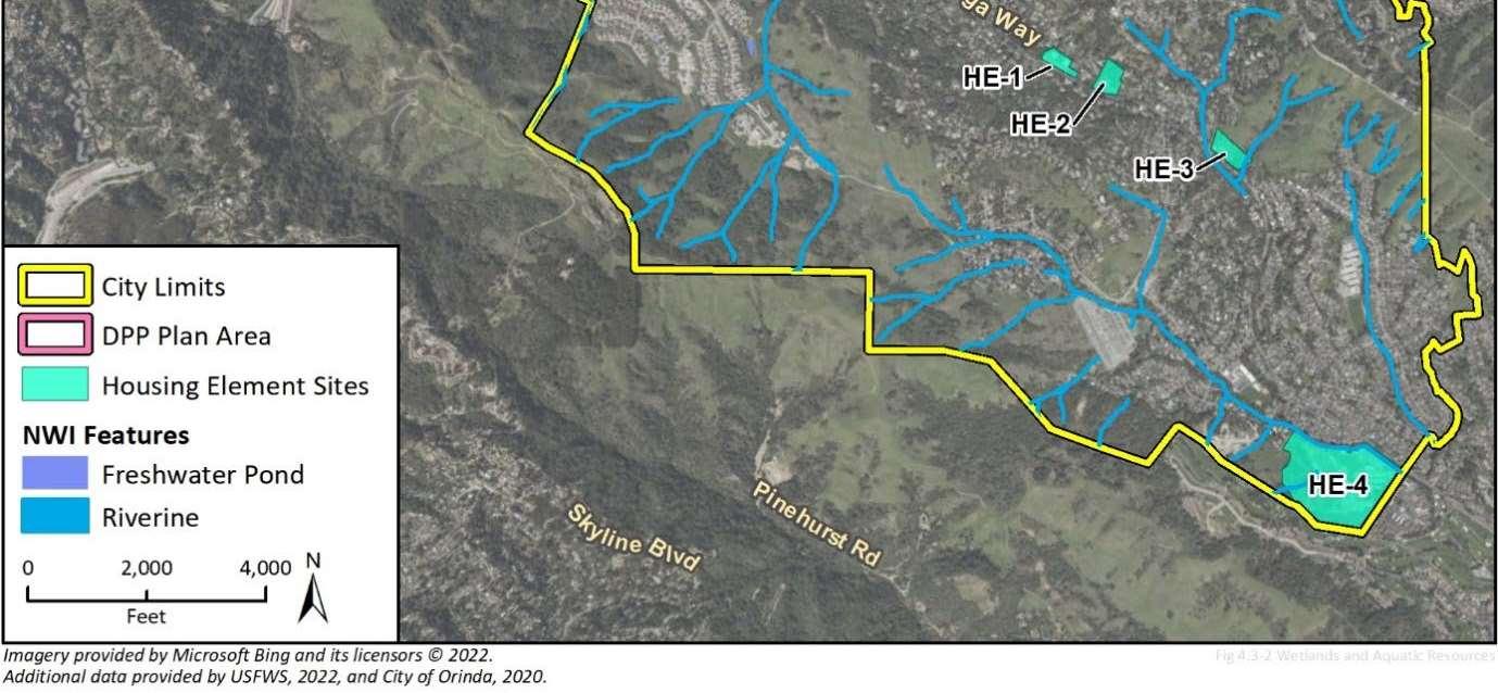
ENVIRONMENTAL SETTING
The HE areas of the Project covers approximately 74.59 acres cumulatively across five separate areas (see figure 1). HE-1 consists of 3.22 acres of developed land which currently holds a building utilized as a place of worship. HE-2 and HE-3 consists of 4.48 acres, and 4.94 acres respectively, of partially developed land which currently hold buildings utilized as places of worship and undeveloped hillslopes containing native and non-native trees and vegetation. HE-4 consists of 51.95 acres of undeveloped open space containing native and non-native trees and vegetation. HE-5 consists of 10 acres of public/semipublic undeveloped open space containing native and non-native trees and vegetation. The HE areas open space features are comprised of annual grasslands, oak savannah, mixed oak woodlands, and scrubland; all of which are adjacent to lands where positive occurrence records of Alameda whipsnake (AWS) (Masticophis lateralis euryxanthus; Swaim, 2006 and 2010) are located and are within dispersal distance. In addition to AWS, the Project areas contains habitat for nesting birds, fossorial mammals, roosting bats, and rare plants such as the California Native Plant Society’s (CNPS) Rare Plant Rank 1.B2 species: bent-flowered fiddleneck (Amsinckia lunaris; East Bay Municipal Utility District (EBMUD), 2018), western leatherwood (Dirca occidentalis; EBMUD, 2021), and Diablo helianthella (Helianthella castanea; EBMUD, 2015). The topography of the Project sites holds features which contain contributing tributaries to, or are directly adjacent to, San Pablo Creek.
Page
2
DocuSign Envelope ID: C44F2E38-661B-4094-AF19-E0C59BFFA1CA 13
Ms. Winnie Mui
City of Orinda October 31, 2022
The Downtown Precise Plan area consists of approximately 60 acres of urban development adjacent to San Pablo creek which includes native and non-native trees and vegetation. The Downtown Precise Plan area also includes sites proposed for future riparian restoration areas and a creek side trail. San Pablo Creek historically and currently holds records of California red-legged frog (CRLF) (Rana draytonii; Beeman, 2007)
The immediate neighboring parcels to HE 1 through 4 and Downtown Precise Plan areas are comprised of suburban development and mixed open space that contain native and ornamental trees, and other vegetation or infrastructure, that provide potential nesting habitat for birds and potential roosting habitat for bats. The parcels immediately neighboring HE-5 are comprised primarily of undeveloped open space with the exception of a municipal park development to the southeast. Within a two-mile radius are designated open space areas including portions of EBMUD-owned watershed areas, East Bay Regional Parks District-managed lands, and privately held open space. These neighboring, adjacent, private and public open space areas hold potential habitat, habitat corridors. Within a 2-mile radius of these areas, there are positive occurrence records of special-status species, including but not limited to, AWS, CRLF, San Francisco dusky-footed woodrat (Neotoma fuscipes annectens), and the above listed CNPS-listed rare plants.
Closely Related Past, Present, and Reasonably Foreseeable Probable Future Projects
The draft EIR acknowledges that the Project would contribute to the ongoing loss of partially and/or undeveloped lands and would cumulatively impact biological resources without implementation of the mitigation measures required by the draft EIR and other agency driven regulations. However, the draft EIR does not identify specific compensatory mitigation measures to permanently conserve and protect habitats for the impacted special-status species to reduce the impacts from permanent and cumulative loss of their habitats to a level of less-than-significant. Without modifications made to the provided mitigation measures described in this letter, the Project has the potential to result in cumulative impacts over time such as the permanent removal of existing open space, and vacant lands, as described in the draft EIR Some land use changes appear to overlap with areas of the Project that have been mapped as sensitive natural communities, such as oak woodland, or hold critical habitat and/or connectivity for AWS and are within a reasonable dispersal distance for the species from known occurrences (Swaim, 2006 and 2010). The loss of sensitive natural communities and connectivity areas would be cumulatively considerable and could cause potentially significant impacts to the biological resources in and adjacent to the Project. To reduce these impacts to a level of less-than-significant, CDFW recommends that the draft EIR be revised to include the following:
Page
3
DocuSign Envelope ID: C44F2E38-661B-4094-AF19-E0C59BFFA1CA 2.1 2.2 14
Ms. Winnie Mui
City of Orinda October 31, 2022
1. Map of sensitive natural communities and connectivity areas for AWS, existing land use designations, and full buildout land use designations that clearly identifies the proposed loss of essential connectivity areas.
2. Include the modification to the mitigation measures provided for in this letter as recommended by CDFW
3. Reduce, redesign, restrict, or remove portions of the HE areas that would specifically result in the loss of sensitive natural communities or connectivity areas for AWS.
CEQA requires a Mandatory Finding of Significance if a project is likely to substantially restrict the range or reduce the population of a threatened or endangered species. (Pub. Resources Code, §§ 21001, subd. (c) and 21083; CEQA Guidelines, §§ 15380, 15064, and 15065). Impacts must be avoided or mitigated to less-than-significant levels unless the CEQA Lead Agency makes and supports Findings of Overriding Consideration (FOC). The CEQA Lead Agency’s FOC does not eliminate the Project proponent’s obligation to comply with CESA or other aspects of Fish and Game Code.
COMMENTS AND RECOMMENDATIONS
CDFW offers the comments and recommendations below to assist the City in adequately identifying and/or mitigating the Project’s significant, or potentially significant, direct and indirect impacts on fish, plant, wildlife, and associated habitat (biological) resources.
Revision to Impacts Analysis and Findings
The draft EIR neglects to analyze or disclose permanent loss of habitat for specialstatus species, nor does it include mitigation measures to reduce this impact to a level of less-than-significant. Instead, the draft EIR limits the scope of its analysis to habitat conversion and is silent on when this conversion results in permanent loss of the habitat when it no longer is viable for use by special-status species. CDFW recommends that the draft EIR be revised and recirculated to include an analysis of permanent habitat loss impacts for special-status species and incorporate this analysis into the Lead Agency’s significance determination. Based on this analysis the City should revise the draft EIR to also incorporate compensatory mitigation measures in the form of permanent protection and management of like for like habitats through a legal instrument, such as a conservation easement, with an endowment for habitat management. The revised impacts analysis and mitigation measures should then be incorporated into the Findings in the Final EIR
Page
4
DocuSign Envelope ID: C44F2E38-661B-4094-AF19-E0C59BFFA1CA
15
2.3 2.4 2.5 2.6 2.7
Ms. Winnie Mui
City of Orinda
31, 2022
Revisions to Proposed Mitigation Measures
The mitigation measures provided for in the draft EIR call out when the triggers for such measures will occur at HE areas 3 through 5, yet HE-2 holds undeveloped sections of oak savanna. CDFW recommends that HE-2 be included in mitigation measures BIO-1 through 7 and BIO-9 through 13. CDFW also recommends the following edits and additions to the provided mitigation measures found in the draft EIR below:
BIO-1: CDFW recommends that screening and assessments for special-status species include areas where a species has potential to occur. Due to decreasing amounts of what would normally be considered “suitable habitat”, wildlife is being forced to occupy sub-optimal, marginal habitat because that is all that is available to them. For example, AWS is known to utilize asphalt for basking, bats often utilize duff for roosting, and bentflowered fiddleneck has been documented to occur in unimproved road turnouts.
BIO-2: CDFW recommends that project-specific special-status plant surveys be conducted for the species with the potential to occur within HE areas 2 through 5. To ensure impacts to special-status plants are mitigated to a level of less-than-significant, CDFW recommends that the Project area be surveyed for special-status plants by a qualified botanist following the Protocols for Surveying and Evaluating Impacts to Special-status Native Plant Populations and Sensitive Natural Communities (https://nrm.dfg.ca.gov/FileHandler.ashx?DocumentID=18959&inline). This protocol includes the identification of reference populations and adjacent potential habitat areas, to assist in the accuracy and timing of a Project area’s floristic surveys. The results of surveys following the protocol should be summarized into Botanical Survey Reports, as found on page nine of the protocol, and be incorporated into a revised Draft EIR other subsequent environmental documents as necessary. In the absence of protocol-level surveys being performed, additional surveys may be necessary. Additionally, annual weather variance, including, but not limited to, drought conditions when a Project’s biological survey was conducted, may result in the need for additional floristic surveys to be performed.
BIO-4: The proposed 1:1 (mitigation to impact) ratio does not meet the minimum standard for replacement, given loss of habitat over the course of time, and recovery Moreover, the proposed 80% success criteria for restoration plantings could result in a net loss, and therefore failure to achieve even the proposed 1:1 ratio To reduce the Project’s potentially significant impacts to special-status plants to a level of less-thansignificant, CDFW recommends that BIO-4 be revised to provide compensatory mitigation at a minimum of a 3:1 (mitigation to impact) ratio for permanent impacts, and a 1.1:1 (mitigation to impact) ratio for temporary impacts to special-status plants and their habitats Revisions may include, but are not limited to, the preservation and enhancement of on-site and/or adjacent populations, seed collection or transplanting of
Page
October
5
DocuSign Envelope ID: C44F2E38-661B-4094-AF19-E0C59BFFA1CA 2.8 2.9 2.10 2.11 16
Ms. Winnie Mui
City of Orinda
October 31, 2022
on-site individuals/populations, and preservation of occupied habitat on-site or off-site adjacent to a Project-impacted area.
BIO-5: CDFW recommends the following edits to BIO-5:
“If the results of the project-specific biological analysis, for projects within any Housing Element site sites HE- 3, 4, and 5 determine that suitable potential habitat is present for any federal or State listed species or other special-status species, a qualified biologist shall complete protocol habitat assessments/surveys in accordance with CDFW and/or USFWS protocols prior to issuance of any construction permits.”
BIO-6: CDFW recommends that any Project activities occurring within or adjacent to riparian areas are conducted and completed between June 1 and October 15 of any work year to reduce impacts not only to sensitive aquatic species, but all species that utilize riparian areas and the habitat that supports them
BIO-7: The survival rate of evicted or excluded bats through the use of exclusion measures, such as one-way valves, is unknown. All possible avoidance and minimization measures should be considered before temporary or permanent exclusion and closure of roosting areas is implemented in order to avoid take of bats. Passive relocation is not considered take avoidance, minimization, or mitigation. If complete avoidance of impacts to bats is not possible, or cannot be confirmed as in the case of passive relocation then CDFW recommends that replacement artificial bat roosts (e.g., bat houses, or equivalent) be installed, monitored, and managed by a qualified biologist.
BIO-8: CDFW recommends the following language be used to replace existing language in BIO-8 regarding nesting birds:
Birds. Project Proponents are responsible for ensuring that the work activities do not result in any violation of Fish and Game Code. If activities will occur during nesting bird season (February 15 to September 15), a qualified biologist will conduct focused surveys for active nests within 5 days prior to the initiation of said activities that could impact nesting birds. Surveys will be conducted in all potential habitat located at, and adjacent to, project work sites and in staging and storage areas. The minimum survey radii surrounding the work area will be the following: (1) 250 feet for non-raptors, and (2) 1,000 feet for raptors. If a lapse in project-related activities of 7 days or longer occurs, another focused survey will be required before Project activities can be reinitiated.
Active Nests. A qualified biologist will observe any identified active nests prior to the start of any construction-related activities to establish a behavioral baseline of the adults and any nestlings. Once work commences, all active nests should be continuously monitored by a qualified biologist to detect any
Page
6
DocuSign Envelope ID: C44F2E38-661B-4094-AF19-E0C59BFFA1CA 2.11
17
2.12 2.13 2.14 2.15
Ms. Winnie Mui
City of Orinda October 31, 2022
signs of disturbance and behavioral changes as a result of Project activities. In addition to direct impacts, such as nest destruction, nesting birds might be affected by noise, vibration, odors and movement of workers or equipment. If signs of disturbance and behavioral changes are observed, a qualified biologist will be responsible to cease work causing that change, and may elect to contact CDFW for guidance prior to the recommencement of activities.
Active Nest Buffers. Active nest sites and protective buffer zones shall be designated as “Ecologically Sensitive Areas” where no project-related activities or personnel may enter. These designated areas shall be protected during project activities with the establishment of a fence barrier or flagging surrounding the nest site. A qualified biologist shall determine the necessary buffer to protect nesting birds based on existing site conditions, such as construction activity and line of sight, and shall increase buffers if needed to provide sufficient protection of nesting birds and their natural behaviors.
BIO-12: CDFW recommends that nursery plants selected for restoration be purchased from a source nursery that is in compliance with annual inspections under 7 CFR 301.92, et seq for sudden oak death. A qualified biologist shall check the California Department of Food and Agriculture’s website to view the most recent list of approved nurseries from quarantined and regulated counties, found at: https://www.cdfa.ca.gov/plant/pe/InteriorExclusion/SuddenOakDeath/. Sudden oak death may not be detectable by visual inspection alone, thus Project Proponents should utilize clean nursery stock available from a certified nursery to avoid transmitting the disease.
BIO-13: CDFW recommends deletion of language that delegates responsibility to a qualified biologist to determine whether a project will have the potential to impact a river, lake or stream and instead require projects to notify CDFW for a formal determination of whether the project requires a Lake and Streambed Alteration (LSA) Agreement.
REGULATORY AUTHORITY
Lake and Streambed Alteration
CDFW requires a Notification, pursuant to Fish and Game Code section 1600 et seq., for Project activities affecting lakes or streams and associated riparian habitat. Notification is required for any activity that may substantially divert or obstruct the natural flow; change or use material from the bed, channel, or bank including associated riparian or wetland resources; or deposit or dispose of material where it may pass into a river, lake, or stream. Work within ephemeral streams, washes, watercourses with a subsurface flow, and floodplains are subject to Notification requirements. In this case, CDFW would consider the CEQA document for the Project and may issue an LSA
Page
7
DocuSign Envelope ID: C44F2E38-661B-4094-AF19-E0C59BFFA1CA
18
2.15 2.16 2.17 2.18
Ms. Winnie Mui
City of Orinda
October 31, 2022
Agreement. CDFW may not execute the final LSA Agreement until it has complied with CEQA as a Responsible Agency.
California Endangered Species Act
Please be advised that CDFW recommends that a CESA Incidental Take Permit (ITP) should be obtained if the Project has the potential to result in “take” of plants or animals listed under CESA, such as AWS or pallid manzanita (Arctostaphylos pallida), either as a result of construction or over the life of the Project. Issuance of an ITP is subject to CEQA documentation; the CEQA document must specify impacts, mitigation measures, and a mitigation monitoring and reporting program. If the Project will impact CESA-listed species, early consultation is encouraged, as significant modification to the Project and mitigation measures may be required in order to obtain an ITP.
Fully Protected Species
Fully Protected species such as golden eagle, and white-tailed kite, may not be taken or possessed at any time (Fish & G Code, §§ 3511, 4700, 5050, & 5515).
Raptors and Other Nesting Birds
CDFW has jurisdiction over actions that may result in the disturbance or destruction of active nest sites or the unauthorized take of birds. Fish and Game Code sections protecting birds, their eggs, and nests include sections 3503 (regarding unlawful take, possession or needless destruction of the nests or eggs of any bird), 3503.5 (regarding the take, possession or destruction of any birds-of-prey or their nests or eggs), and 3513 (regarding unlawful take of any migratory nongame bird).
ENVIRONMENTAL DATA
CEQA requires that information developed in environmental impact reports and negative declarations be incorporated into a database which may be used to make subsequent or supplemental environmental determinations. (Pub. Resources Code, § 21003, subd. (e)) Accordingly, please report any special-status species and natural communities detected during Project surveys to the California Natural Diversity Database (CNDDB). The CNDDB field survey form can be filled out and submitted online at the following link: https://wildlife.ca.gov/Data/CNDDB/Submitting-Data. The types of information reported to CNDDB can be found at the following link: https://www.wildlife.ca.gov/Data/CNDDB/Plants-and-Animals
ENVIRONMENTAL DOCUMENT FILING FEES
The Project, as proposed, would have an impact on fish and/or wildlife, and assessment of environmental document filing fees is necessary. Fees are payable upon filing of the
Page
8
DocuSign Envelope ID: C44F2E38-661B-4094-AF19-E0C59BFFA1CA
19
2.18 2.19 2.21 2.22 2.20
C44F2E38-661B-4094-AF19-E0C59BFFA1CA
Ms. Winnie Mui
City of Orinda
October 31, 2022
Notice of Determination by the Lead Agency and serve to help defray the cost of environmental review by CDFW. Payment of the environmental document filing fee is required in order for the underlying project approval to be operative, vested, and final. (Cal. Code Regs, tit. 14, § 753.5; Fish & G. Code, § 711.4; Pub. Resources Code, § 21089).
CDFW appreciates the opportunity to comment on the draft EIR to assist the City in identifying and mitigating Project impacts on biological resources.
Questions regarding this letter or further coordination should be directed to Andrew Chambers, Environmental Scientist, at (707) 266-2878 or Andrew.Chambers@wildlife.ca.gov; or Michelle Battaglia, Senior Environmental Scientist (Supervisory), at Michelle.Battaglia@wildlife.ca.gov.
Sincerely, Erin Chappell Regional Manager Bay Delta Region

ec: Office of Planning and Research, State Clearinghouse (SCH No. 2022010392)
ATTACHMENTS
Figure 1 – Housing Element Areas Map (City of Orinda, 2022)
Figure 2 – Downtown Precise Plan Map (City of Orinda, 2022)
LITERATURE CITED
Beeman, G.A. (2007). California red-legged frog [ds45]. Calif. Dept. of Fish and Wildlife. Biogeographic Information and Observation System (BIOS). Retrieved October 5, 2022, from https://wildlife.ca.gov/Data/BIOS.
East Bay Municipal Utility District. (2018). Bent-flowered fiddleneck [ds45]. Calif. Dept. of Fish and Wildlife. Biogeographic Information and Observation System (BIOS). Retrieved October 5, 2022, from https://wildlife.ca.gov/Data/BIOS
East Bay Municipal Utility District. (2018). Diablo helianthella [ds45]. Calif. Dept. of Fish and Wildlife. Biogeographic Information and Observation System (BIOS). Retrieved October 5, 2022, from https://wildlife.ca.gov/Data/BIOS.
Page 9
DocuSign Envelope ID:
2.22 20
Ms. Winnie Mui
City of Orinda October 31, 2022
East Bay Municipal Utility District. (2021). Western leatherwood [ds45]. Calif. Dept. of Fish and Wildlife. Biogeographic Information and Observation System (BIOS). Retrieved October 5, 2022, from https://wildlife.ca.gov/Data/BIOS
Swaim, K. (2006 and 2010). Alameda whipsnake [ds45]. Calif. Dept. of Fish and Wildlife. Biogeographic Information and Observation System (BIOS). Retrieved October 5, 2022, from https://wildlife.ca.gov/Data/BIOS
Page
10
DocuSign Envelope ID: C44F2E38-661B-4094-AF19-E0C59BFFA1CA 21
Figure4.3-1WetlandsandAquaticResourcesinOrinda

4.3-6
CityofOrinda PlanOrinda
22
2-20
23
CityofOrinda PlanOrinda
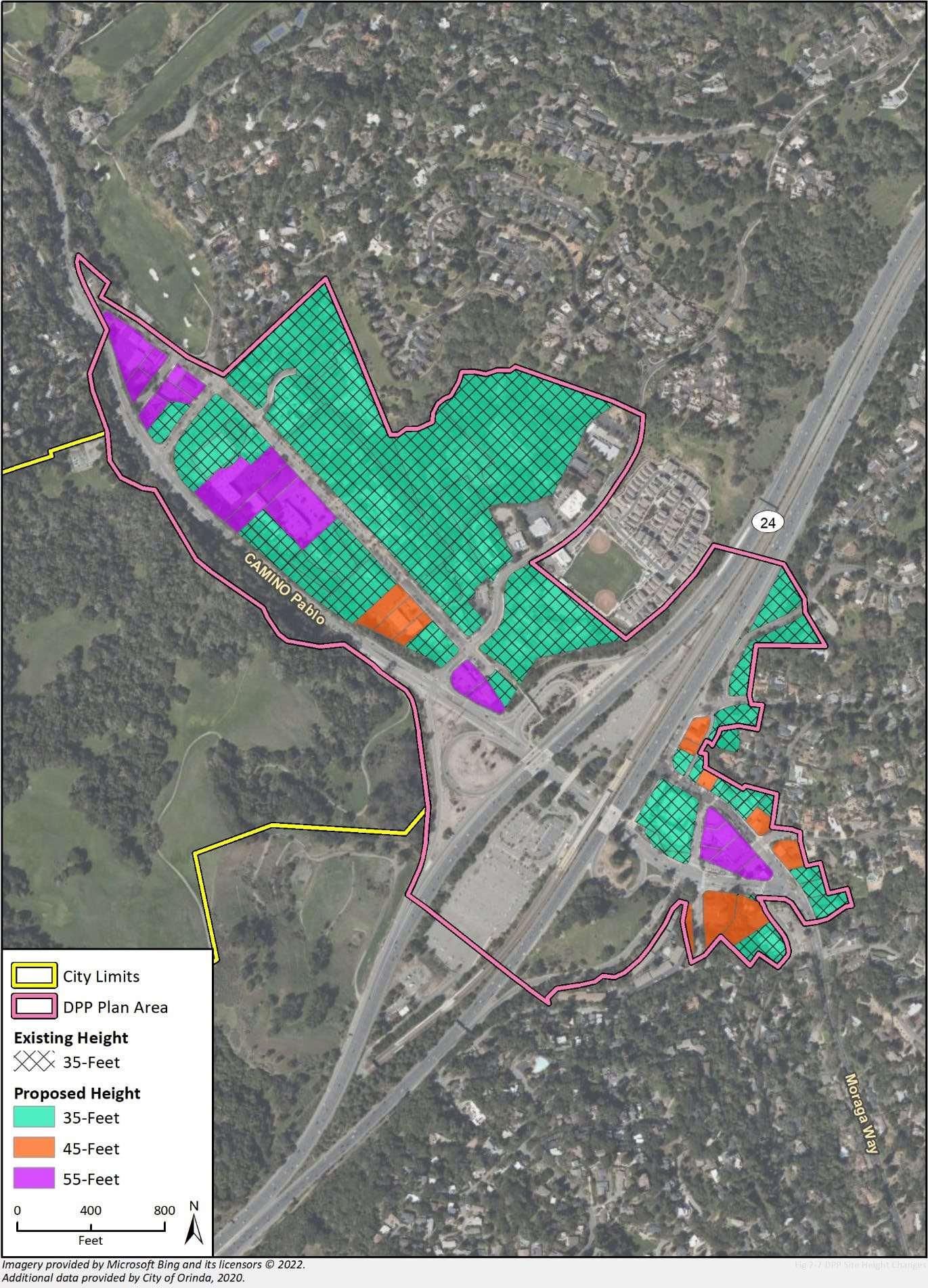
Figure2-7DPPProposedHeightLimits
COMMENTER: Erin Chappell, Regional Manager-Bay Delta Region, California Department of Fish and Wildlife
DATE: October 31, 2022
Response A2.1
The commenter states that the draft EIR does not identify specific compensatory mitigation measures to permanently conserve and protect habitats for potentially impacted special-status species and suggests that such measures are needed to reduce the impacts from permanent and cumulative loss of habitat and connectivity areas to a level of less-than-significant.
As described in Section 2, Project Description, Plan Orinda includes the Housing Element Update, the DPP and associated General Plan updates and rezoning, and revisions to the Environmental Resources Chapter of the General Plan. No specific development projects are proposed under the project, and site conditions/species statuses may change over the life of Plan Orinda; therefore, the existing conditions described in the EIR are based on a desk top review of agency databases and publicly available information Figure 4.3-2 Critical Habitat in Orinda depicts the location of a small amount of designated critical habitat in relation to the Housing Element sites and DPP area.
Additionally, Figure 4.3-3 Essential Connectivity Areas depicts areas with less permeable surfaces (undeveloped areas) that may provide habitat for special-status species The impact analysis methodology for biological resources is programmatic, and cannot identify specific impact acreages or compensatory mitigation requirements. The EIR also notes that impacts to listed species would require consultation with state or federally agencies, in compliance with state and federal laws. Mitigation measure BIO-4 requires mitigation at a minimum ratio of 1:1 for impacts to special status plant habitat; BIO-11 would require avoidance of sensitive natural communities and critical habitat, and BIO-12 would require mitigation at a minimum ratio of 1:1 for impacts to sensitive natural communities. The requirement for a 1:1 ratio is considered industry standard and provides a starting place for project applicants to begin the compensatory mitigation process. This measure is intended to apply to a variety of projects, and individual impacts and compensatory mitigation ratios will be determined on a project by project basis following the preparation of an initial biological resources assessment, as required in Mitigation Measure BIO-1. No revisions to the EIR are necessary in response to this comment.
Response A2.2
The commenter suggests that there are proposed land use changes in some areas that are mapped as sensitive natural communities, or which hold critical habitat for Alameda whipsnake (AWS) which would result in cumulatively considerable impacts to biological resources that could be potentially significant.
Mitigation Measure BIO-12, Restoration for Impacts to Sensitive Natural Communities and Critical Habitat, requires a minimum ratio of 1:1 mitigation acreage, onsite or through funding for the acquisition and in-perpetuity management of similar habitat, within Housing Element Sites HE-3, HE4, and HE-5 (including riparian areas that may qualify as waters of the State and/or waters of the U.S. under the jurisdiction[s] of the CDFW, RWQCB, and/or USACE). Critical habitat for AWS only occurs in two small areas totaling less than 3 acres of the approximately 10.19-acre Housing Element Site HE-5 located at the intersection of State Route 24 and California Shakespeare Theater Way/Wilder Road; however, no Primary Constituent Elements (PCEs) for AWS occur within the two
Written
City of Orinda Plan Orinda
Comments and Responses Final Environmental Impact Report/ Responses to Comments on the Draft EIR
Letter A2
24
small areas of critical habitat at this site due to presence of eucalyptus stands without adjacent patches of any scrub/shrub communities. PCEs are considered essential to the conservation of the species and may require special management considerations and protection. Given the project’s lack of PCEs for AWS, the project would not result in cumulatively considerable impacts to critical habitat for AWS. Furthermore, impacts to sensitive natural communities would be mitigated to less than significant levels through implementation of Mitigation Measure BIO-12 and, therefore, the project would not result in cumulatively considerable impacts to sensitive natural communities. No revisions to the EIR are necessary in response to this comment.
Response A2.3
The commenter recommends that the EIR be revised to include a map of sensitive natural communities and connectivity areas for AWS, existing land use designations, and full buildout land use designations that clearly identifies potential loss of essential connectivity areas.
The Draft EIR includes Figure 4.3-2, Critical Habitat in Orinda, and Figure 4.3-3, Essential Connectivity Areas in Orinda, which include the Housing Element Sites and DPP area. The existing conditions discussion in the Draft EIR is based on a desktop analysis of agency databases and publicly available information. No fieldwork was conducted, or is required, for a high-level programmatic analysis. Future development projects proposed under Plan Orinda would be required to comply with all applicable federal and State laws, including project-specific environmental review. No revisions to the EIR are necessary in response to this comment.
Response A2.4
The commenter recommends the EIR be revised to include modification of mitigation measures provided for AWS further in the letter. Please refer to responses A2.8 through A2.17.
Response A2.5
The commenter recommends the EIR be revised to reduce, redesign, restrict, or remove portions of the HE areas that would specifically result in the loss of sensitive natural communities or connectivity areas for AWS. This comment is addressed above in Response A2 2.
Response A2.6
The commenter expresses concern that the EIR does not analyze or disclose permanent loss of habitat for special-status species resulting from habitat conversion. The commenter recommends that the draft EIR be revised to include an analysis of permanent habitat loss impacts for specialstatus species and incorporate this analysis into the Lead Agency’s significance determination. This comment is addressed above in responses A2.1, A2.2, and A2.3. Recirculation of the EIR is not warranted.
Response A2.7
The commenter recommends that the City should revise the draft EIR to incorporate compensatory mitigation measures in the form of permanent protection and management of like-for-like habitats
Final Environmental Impact Report/ Responses to Comments on the Draft EIR
City of Orinda Plan Orinda Written Comments and Responses
25
City of Orinda Plan Orinda Written Comments and Responses
through a legal instrument, such as a conservation easement, with an endowment for habitat management.
This comment is addressed above in Response A2 2.
Response A2.8
The commenter recommends that Site HE-2 be included in mitigation measures BIO-1 through 7 and BIO-9 through 13 due to the presence of oak savanna in undeveloped sections of the site.
In response to this comment the following changes were made to the Draft EIR:
Section 4.33, Pages 4.3-20-28
BIO-1 Biological Resources Screening and Assessment
For projects within Housing Element Sites HE-2, HE-3, HE-4, and HE-5 that would require grading or vegetation trimming or removal, the project applicant shall hire a qualified biologist to perform a preliminary biological resources screening, for the City’s review and approval, to determine whether the project has the potential to impact special status biological resources, inclusive of special status plants and animals, sensitive vegetation communities, jurisdictional waters (including creeks, drainages, streams, ponds, vernal pools, riparian areas and other wetlands), critical habitat, wildlife movement area, or biological resources protected under local or regional ordinances or an existing HCP or NCCP. If it is determined that the project has no potential to impact biological resources, no further action is required.
The change noted above was made to mitigation measures BIO-1 through BIO-7 and BIO-9 through BIO-13 on pages 4.3-20-28 in the Draft EIR. The full text has been abbreviated for space in this response.
Section 4.33, Page 4.3-19
Housing Element Site HE-1 and 2 are is developed and isolated from natural habitats; therefore, special status plants are not expected to occur.
Response A2.9
The commenter recommends that Mitigation Measure BIO-1 be revised to include screening and assessments for special-status species that include areas where a species has potential to occur.
Mitigation Measure BIO-1 requires a preliminary biological resources screening to determine whether the project has the potential to impact special status biological resources, inclusive of special status plants and animals, sensitive vegetation communities, jurisdictional waters (including creeks, drainages, streams, ponds, vernal pools, riparian areas and other wetlands), critical habitat, wildlife movement area, or biological resources protected under local or regional ordinances or an existing HCP or NCCP. Industry standard for a biological assessment includes an evaluation of a species’ potential to occur within a project site, taking into account individual species use of urban, sub-optimal, or marginal habitats. Because Mitigation Measure BIO-1 already requires screening and assessments for special-status species impacts, no revisions to the EIR are necessary in response to this comment.
Final Environmental Impact Report/ Responses to Comments on the Draft EIR
26
Response A2.10
The commenter recommends that Mitigation Measure BIO-2 be revised to include project-specific special-status plant surveys to be conducted by a qualified botanist for the species with the potential to occur within HE areas 2 through 5. The commenter recommends that these surveys be completed following the Protocols for Surveying and Evaluating Impacts to Special-status Native Plant Populations and Sensitive Natural Communities.
Mitigation Measure BIO-1 requires floristic, seasonally timed surveys to coincide with the target plant species blooming season or identifiable period identified in the project-specific biological analysis. Mitigation Measure BIO-2 also requires these surveys be conducted in accordance with the most current protocols established by the CDFW, USFWS, and the local jurisdiction if said protocols exist. Because Mitigation Measure BIO-1 already requires screening and assessments for specialstatus species impacts, no revisions to the EIR are necessary in response to this comment.
Response A2.11
The commenter states an opinion that Mitigation Measure BIO-4 does not meet the minimum standard for replacement of habitat loss over time. The commenter recommends that Mitigation Measure BIO-4 be revised to provide compensatory mitigation at a minimum of a 3:1 (mitigation to impact) ratio for permanent impacts, and a 1.1:1 (mitigation to impact) ratio for temporary impacts to special-status plants and their habitats.
Mitigation Measure BIO-4 provides a programmatic measure intended to require a minimum mitigation ratio for species habitat loss compensation across a wide range of projects. The measure states that this is a minimum ratio and that the final ratio will be determined by the City in coordination with CDFW and USFWS as applicable for each species and habitat. The requirement for a 1:1 ratio is considered industry standard and provides a starting place for project applicants to begin the compensatory mitigation process. This measure is intended to apply to a variety of projects, and individual impacts and compensatory mitigation ratios will be determined on a project by project basis following the preparation of an initial biological resources assessment, as required in Mitigation Measure BIO-1. A qualified biologist would develop the mitigation and monitoring plan based on the project specific impacts. No revisions to the EIR are necessary in response to this comment.
Response A2.12
The commenter recommends specific edits to Mitigation Measure BIO-5.
In response to Comment A2-8, Housing Element Site HE-2 was added into mitigation measures BIO1 through 7 and BIO-9 through 13 on pages 4.3-20-28 in Section 4.33 of the Draft EIR. Housing Element Site HE-1 is fully developed and isolated from natural habitats; therefore, special status plants are not expected to occur. Mitigation Measure BIO-5 is specific to federal or State listed species impacts. No revisions to the EIR are necessary in response to this comment.
Response A2.13
The commenter recommends that Mitigation Measure BIO-6 be revised to limit project activities occurring within or adjacent to riparian areas to being conducted between June 1 and October 15 of any work year to reduce impacts not only to sensitive aquatic species, but all species that utilize riparian areas and the habitat that supports them.
Written
City of Orinda Plan Orinda
Comments and Responses Final Environmental Impact Report/ Responses to Comments on the Draft EIR
27
In response to this comment the following changes have been made to the Draft EIR:
Section 4.33, Page 4.3-22
All projects occurring within/adjacent to aquatic habitats (including riparian habitats and wetlands) shall be completed between April 1 and October 31 June 1 and October 15, to avoid impacts to sensitive aquatic species.
Response A2.14
The commenter states an opinion that the survival rate of bats through use of exclusion measures, such as those included in Mitigation Measure BIO-7, is unknown. The commenter recommends that all possible avoidance and minimization measure be considered before temporary or permanent exclusion measures are implemented. The commenter also states that passive relocation is not considered take avoidance, minimization, or mitigation. If complete avoidance of impacts to bats is not possible, or cannot be confirmed then CDFW recommends that replacement artificial bat roosts (e.g., bat houses, or equivalent) be installed, monitored, and managed by a qualified biologist.
Currently no bat species with the potential to occur are federally or state listed, and roosts would not require avoidance of take under the FESA or CESA. Mitigation Measure BIO-7 states that if active roosts are located, exclusion devices such as netting must be installed to discourage bats from occupying the site. If a roost is determined by a qualified biologist to be used by a large number of bats (large hibernaculum), bat boxes would be installed near the project site. The number of bat boxes installed would depend on the size of the hibernaculum and would be determined through consultations with the CDFW. This measure is intended to address impacts to bats at a programmatic level. The exact methods and exclusion plans would be developed by a qualified biologist based on current industry standards and agency protocols at the time of project implementation. Because Mitigation Measure BIO-7 addresses protection of roosting bats, and additional measures if called for at the time a project is proposed, no revisions to the EIR are necessary in response to this comment.
Response A2.15
The commenter recommends specific text for Mitigation Measure BIO-8 regarding nesting birds Compliance with CFGC (or any federal or state law) is already required and is not considered mitigation for impacts under CEQA. The buffer zones included in Mitigation Measure BIO-8 are typical in developed/semi-rural areas, where access is limited by property lines. Minimum avoidance buffers provide for the establishment of appropriate buffers by a qualified biologist based on the sensitivity of the species, construction activities, and line of site to the nest. In response to this comment, the following revisions have been made to the EIR:
Section 4.3, Pages 4.3-24 to 4.3-25
BIO-8 Pre-construction Surveys for Nesting Birds for Construction Occurring within Nesting Season
For projects in any of the Housing Element Sites or DPP area that require the removal of trees or vegetation that may contain a nesting bird, construction activities shall occur outside of the nesting season wherever feasible (September 16 to January 31February 14), and no mitigation activity will be required. If construction activities must occur during the nesting season (February 15 to September 15), a qualified biologist shall conduct surveys for nesting birds covered by the CFGC and
City of Orinda Plan Orinda Written Comments and Responses Final Environmental Impact Report/ Responses to Comments on the Draft EIR
28
MBTA no more than 14 days prior to vegetation removal. The surveys shall include the entire segment disturbance area plus a 200-foot buffer around the site or a designated buffer to the satisfaction of the jurisdictional agency. If active nests are located, all construction work shall be conducted outside a buffer zone from the nest to be determined by the qualified biologist. The buffer shall be a minimum of 50 feet for non-raptor bird species and at least 150 feet for raptor species. Larger buffers may be required depending upon the status of the nest and the construction activities occurring in the vicinity of the nest. The buffer area(s) shall be closed to all construction personnel and equipment until the adults and young are no longer reliant on the nest site. A qualified biologist shall confirm that breeding/nesting is completed, and young have fledged the nest prior to removal of the buffer. A report of these preconstruction nesting bird surveys shall be submitted to the City to document compliance within 30 days of its completion.
Response A2.16
The commenter recommends that nursery plants selected for restoration as part of Mitigation Measure BIO-12 be purchased from a source nursery that is in compliance with annual inspections under 7 CFR 301.92, et seq. for sudden oak death. In response to this comment the following changes have been made to the Draft EIR:
Section 4.3.3, Page 4.3-27
Sudden Oak Death. A qualified biologist shall inspect all nursery plants used in restoration for sudden oak death. Nursery plants selected for restoration shall be purchased from a nursery that is in compliance with annual inspections under 7 CFR 301.92, et seq. for sudden oak death. Vegetation debris shall be disposed of properly and vehicles and equipment shall be free of soil and vegetation debris before entering natural habitats. Pruning tools shall be sanitized.
Response A2.17
The commenter recommends deletion of language that delegates responsibility to a qualified biologist to determine whether a project will have the potential to impact a river, lake or stream and instead require projects to notify CDFW for a formal determination of whether the project requires a Lake and Streambed Alteration (LSA) Agreement.
Mitigation Measure BIO-13 requires a preliminary jurisdictional delineation following the current field protocols, such as the Review of Ordinary High Water Mark Indicators for Delineating Arid Streams in the Southwestern United States (USACE 2004), Distribution of Ordinary High Water Mark (OHWM) Indicators and Their Reliability in Identifying the Limits of “Waters of the United States” in Arid Southwestern Channels (USACE 2006), A Field Guide to the Identification of the Ordinary High Water Mark (OHWM) in the Arid West Region of the Western United States (USACE 2008b), and Updated Datasheet for the Identification of the Ordinary High Water Mark (OHWM) in the Arid West Region of the Western United States (USACE 2010). The results of the preliminary jurisdictional delineation and impact analysis are required prior to any permit applications, including a CDFW Lake and Streambed Alteration Agreement. No revisions to the EIR are necessary in response to this comment.
Final Environmental Impact Report/ Responses to Comments on the Draft EIR
City of Orinda Plan Orinda Written Comments and Responses
29
Response A2.18
The commenter explains the requirement to notify CDFW about any project activity that affects lakes or streams and associated riparian habitat. The commenter explains that the CEQA document for the project will be considered by CDFW to determine whether or not a Lake and Streambed Alteration Agreement will be issued.
Although this comment does not pertain to the analysis or conclusions of the EIR, adoption of a program such as Plan Orinda does not meet the requirements for permitting. There is a small chance that a future project could be located near a jurisdictional lake or stream, and in those cases CDFW would be notified pursuant to Fish and Game Code Section 1602 for review and permitting of activities that would impact the river, lake, stream, or other similar watercourse; however, Plan Orinda is a land use plan that does not propose specific development and CDFW is not a responsible agency for plan adoption. No revisions to the EIR are necessary in response to this comment.
Response A2.19
The commenter explains that a California Endangered Species Act (CESA) Incidental take Permit should be obtained if the Project has the potential to result in a “take” of plants or animals listed under CESA (either as a result of construction or over the life of the project) and that fully protected species such as golden eagle, and white-tailed kite may not be taken or possessed at any time. Issuance of an ITP is subject to CEQA documentation; the CEQA document must specify impacts, mitigation measures, and a mitigation monitoring and reporting program.
Because no specific development project is proposed under Plan Orinda, “take” of plants or animals listed under CESA would not occur during the planning stage Environmental impacts of development facilitated by the project would be evaluated on a project level and applicable permitting would be required by law as noted by the commenter. No revisions to the EIR are necessary in response to this comment. See also Response A2.18.
Response A2.20
The commenter explains that CDFW has jurisdiction over actions that may result in the disturbance or destruction of active nest sites or the unauthorized take of birds.
The City recognizes that CDFW has jurisdiction over actions that may result in the disturbance or destruction of active nest sites or the unauthorized take of birds. Nesting birds protected by the CFGC are discussed Section 4.3.3, Impact Analysis, on pages 4.3-19-20, and in Mitigation Measure BIO-8, of the Draft EIR. No revisions to the EIR are necessary in response to this comment.
Response A2.21
The commenter explains the necessary steps to file the information developed in certain CEQA documents into a database to be used for subsequent or supplemental environmental determinations, including submission of any special-status species and natural communities detected during project surveys to the California Natural Diversity Database (CNDDB).
No field surveys were conducted for the Draft EIR; rather, the Draft EIR relied on a desktop analysis in describing the potential for special-status species and natural communities. Subsequent surveys under project-specific mitigation measures would occur after the environmental review for Plan Orinda is complete. No revisions to the EIR are necessary in response to this comment.
City of Orinda Plan Orinda Written Comments and Responses Final Environmental Impact Report/ Responses to Comments on the Draft EIR
30
Response A2.22
The commenter explains the project would have an impact on fish and/or wildlife and that assessment of environmental document filing fees is necessary.
When the City files its Notice of Determination, after the EIR has been certified and the project has been approved by City Council, the City will pay the required CDFW fees. No revisions to the EIR are necessary in response to this comment.
Final Environmental Impact Report/ Responses to Comments on the Draft EIR
Written
City of Orinda Plan Orinda
Comments and Responses
31
DISTRICT 4 OFFICE OF REGIONAL AND COMMUNITY PLANNING P.O. BOX 23660, MS–10D | OAKLAND, CA 94623-0660 www.dot.ca.gov
October 31, 2022
SCH #: 2022010392
GTS #: 04-CC-2022-00526
GTS ID: 25371
Co/Rt/Pm: CC/24/2.49
Winnie Mui, Associate Planner
City of Orinda 22 Orinda Way Orinda, CA 94563
Re: Plan Orinda Draft Environmental Impact Report (DEIR)
Dear Winnie Mui:
Thank you for your response to our Caltrans Notice of Preparation (NOP) comment letter dated February 23, 2022. As noted in our NOP comment letter, we are committed to ensuring that impacts to the State’s multimodal transportation system and to our natural environment are identified and mitigated to support a safe, sustainable, integrated and efficient transportation system. Caltrans is also committed to supporting access to affordable housing and working with our partners to ensure that environmental justice concerns, including potential impacts related to air and noise near the State Transportation System, are addressed in an equitable manner. The following comments are based on our review of the September 2022 DEIR.
As indicated in the DEIR, the draft Housing Element Update identifies several housing sites to meet the City’s Regional Housing Needs Allocation (RHNA). The alternatives presented in the DEIR include two properties owned by Caltrans, one of which is Site HE-5 located at the State Route (SR)-24 Wilder Road exit where up to 408 units are proposed, and the other are the two Orinda BART parking lots where up to 1,089 units are proposed.
Site HE-5
Please note that this site contains aerially deposited lead (ADL), along with other potential contaminants of concern, in the soil adjacent to the existing roadway. This soil was moved from the SR-13/24 interchange to this location when the interchange was upgraded in the 1990s. The visible concrete ditch that surrounds the site is necessary to control on-site storm water runoff along this 1.5:1 slope and to decease
“Provide a safe and reliable transportation network that serves all people and respects the environment”
Letter A3 3.1 32
Winnie Mui, Associate Planner
the likelihood of ADL containing runoff water and solids migrating off State property. As such, this ditch cannot be removed while the contaminated soil is present.
BART Parking Lots
The western BART parking lot (BART B) sits at the base of a large, repaired landslide that is currently dormant. The repairs were completed through the installation of drainage and regrading. While the slide has been dormant for several years, and there are no signs of distress to SR-24, consideration of this dormant land slide must be recognized. Please refer to Attachment A, Orinda Landslide Correction As Built Drawing.
Separately, both BART parking lots (BART A and BART B) are encumbered and have existing joint use agreements and consent to common use agreements with Caltrans. BART has easements on these lots for their station, parking and tracks. The City would need to approach BART to request that it quitclaim its rights to these lots for development.
Additionally, the parcel in the southwestern corner of BART B lot is currently used by Caltrans. Operations and storage of equipment related to roadway safety at this location required approval by the California Department of Public Health. As such, Caltrans’ continued access to, and security/safety of this site, is required.
Site HE-5 and the BART parking lots are not currently deemed excess to Caltrans’ needs. Use of those parcels by the City for housing would require decertification. Caltrans cannot consider decertification of these parcels until an assessment has conducted of their utility for Caltrans’ needs. For more information, including references to the decertification process, please refer to Chapter 26 of the Caltrans Project Development Procedures Manual - Disposal of Rights-of-Way for Public or Private Road Connections.
Classified Landscape Freeway
Under section 4.1.2 of the DEIR, please note that SR-24 from postmile 1.82 through 2.85 is a classified landscape freeway. This classification limits and controls the installation of outdoor advertising along a freeway. Attention to preserving, replacing or enhancing the landscape aesthetic beauty of the area must be given a high priority.
Encroachment Permit
Please be advised that any permanent work or temporary traffic control that encroaches onto Caltrans’ right of way (ROW) requires a Caltrans-issued encroachment permit. As part of the encroachment permit submittal process, the applicant may be asked by the Office of Encroachment Permits to submit a completed encroachment permit application package, digital set of plans clearly delineating Caltrans’ ROW, digital copy of signed, dated and stamped (include stamp expiration date) traffic control plans, this comment letter, the City’s response to the
“Provide a safe and reliable transportation network that serves all people and respects the environment”
3.2 3.3 3.4 3.5 3.6 3.7
Page
October 31, 2022
2
33
Winnie Mui, Associate Planner
comment letter, and where applicable, the following items: new or amended Maintenance Agreement (MA), approved Design Standard Decision Document (DSDD), approved encroachment exception request, and/or airspace lease agreement. The applicant’s application package may be emailed to D4Permits@dot.ca.gov.
Please note that Caltrans is in the process of implementing an online, automated, and milestone-based Caltrans Encroachment Permit System (CEPS) to replace the current permit application submittal process with a fully electronic system, including online payments. The new system is expected to be available during 2022. To obtain information about the most current encroachment permit process and to download the permit application, please visit https://dot.ca.gov/programs/trafficoperations/ep/applications.
Thank you again for including Caltrans in the environmental review process. Should you have any questions regarding this letter, or for future notifications and requests for review of new projects, please email LDR-D4@dot.ca.gov.
Sincerely,
MARK LEONG District Branch Chief Local Development Review
c: State Clearinghouse
“Provide a safe and reliable transportation network that serves all people and respects the environment”

October
Page 3
31, 2022
3.7 34
Attachment
A
Letter A3
COMMENTER: Mark Leong, District Branch Chief, California Department of Transportation (Caltrans)
DATE: October 31, 2022
Response A3.1
The commenter explains that Housing Element Site HE-5 contains aerially-deposited lead and other potential contaminants of concern, and that the concrete ditch on site controls storm runoff and decreases the likelihood of aerially deposited lead containing runoff water and solids migrating off State property; therefore, the ditch cannot be removed while contaminated soil is present.
As described in Section 4.6, Hazards and Hazardous Materials, potential health and environmental impacts related to contaminated groundwater and soil may occur during excavation and dewatering for new construction under both the Housing Element Update and DPP. Development facilitated by the project would require project review by the City prior to issuance of permits. Upon project review, the City would determine if any special requirements apply based on site conditions. Requirements could include preparation of a Phase I Environmental Site Assessment, implementation of a soil and groundwater management plan, and/or a dewatering and monitoring plan to ensure the discharge of clean water. In addition, development facilitated by the project would be subject to regulatory programs such as those overseen by the San Francisco Regional Water Quality Control Board and the Department of Toxic Substances Control. These agencies require applicants for development of potentially contaminated properties to perform investigation and cleanup if the properties are contaminated with hazardous substances. The transport of hazardous materials would be subject to federal, State, and local regulations such as the Toxic Substances Control Act and the Resource Conversation and Recovery Act, Hazardous Waste Control Act, and the Contra Costa County Local Hazard Mitigation Plan. All of these regulations would ensure that development on the site would not have significant, adverse environmental impacts caused by existing soil contamination on-site. Housing Element Site HE-5 is not listed on Geotracker (the state water resources control board database), EnviroStor (Department of Toxic Substances Control database) or CalEnviroScreen. No revisions to the EIR would be necessary in response to this comment.
Response A3.2
The commenter provides information regarding a dormant landslide site near the Bay Area Rapid Transit (BART) B station parking lot.
As shown on Figure 4.5-2, in Section 4.5, Geology and Soils, the BART sites contain landslide susceptibility Class 10 which is a high susceptibility class. Also as described in Section 6.2.2, under Alternative 2, development of the BART sites would be required to comply with California Building Code requirements and to implement General Plan goals and policies, ensuring the stability of new structures during seismic events or due to unstable or expansive soils. Development of the BART sites would be required to comply with the proposed policies from the City of Orinda General Plan Safety Element Update as described in the Draft EIR in Section 6, Alternatives: Geology and Soils Proposed policies, along with code compliance, would reduce potential impacts from a dormant landslide on the BART sites to less than significant The City appreciates this information about the BART station site and will take it into consideration if or when development of the site is proposed. The following revisions to the Draft EIR have been made in response to this comment:
Written
City of Orinda Plan Orinda
Comments and Responses Final Environmental Impact Report/ Responses to Comments on the Draft EIR
36
Page 6-28:
The BART B Station Site proposed as part of Alternatives 2 or 3 is on land with a landslide susceptibility class 10 designation. This means this area is highly susceptible to landslides. Future construction on the sites under Alternatives 2 or 3 would be required to comply with California Building Code requirements and to implement General Plan goals and policies, ensuring the stability of new structures during seismic events or due to unstable or expansive soils such as those that are present on the BART Station B site.
Response A3.3
The commenter states that BART A and Bart B are encumbered and have existing joint use agreements which requires the City to request that BART quitclaim its rights to these lots for development.
Although this comment does not pertain to the analysis or conclusions of the EIR, the comment is noted by City staff and will be forwarded to the decision makers for their consideration.
Response A3.4
The commenter states that Caltrans’ continued access to and security of the parcel in the southwest corner of BART B lot is required.
Although this comment does not pertain to the analysis or conclusions of the EIR, the comment is noted and will be forwarded to the decision makers for their consideration.
Response A3.5
The commenter states that the City will need to request decertification of Site HE-5 and the BART Parking Lots if those lots are to be used for housing.
Although this comment does not pertain to the analysis or conclusions of the EIR, the comment is noted by City staff and will be forwarded to the decision makers for their consideration.
Response A3.6
The commenter explains that SR-24 from postmile 1.82 through 2.85 included in section 4.1.2 of the DEIR is a classified landscape freeway and suggests that attention to preserving the aesthetic beauty of the area must be given high priority.
State Route 24 and potential impacts related to scenic highways are addressed in Section 4.1, Aesthetics. As stated in Section 4.1, Aesthetics, Housing Element Sites HE-1 through HE-4 would not be visible from SR-24 but Housing Element Site HE-5 would be. Implementation of Mitigation Measure AES-1 would reduce impacts related to views from a state scenic highway to less than significant levels. The City appreciates this information about this segment of SR 24 and will take it into consideration if or when projects are proposed. No revisions to the EIR are necessary in response to this comment.
City of Orinda Plan Orinda Written Comments and Responses Final Environmental Impact Report/ Responses to Comments on the Draft EIR
37
Response A3.7
The commenter states the requirements for encroachment permits and the process to get these permits for project specific activities that may encroach Caltrans’ right of way.
Although this comment does not pertain to the analysis or conclusions of the EIR, the comment is noted by City staff and will be forwarded to the decision makers for their consideration.
City of Orinda Plan Orinda Written Comments and Responses Final Environmental Impact Report/ Responses to Comments on the Draft EIR
38
1.1 1.2 1.3
Letter P1
39
Letter P1
COMMENTER: Owen Murphy, Orinda Resident
DATE: September 26, 2022
Response P1.1
The commenter states an opinion that requiring no onsite parking minimums for projects within 0.5 mile of BART stations would have an impact on parking, level of service and emergency evacuation, and that proposed development standards would result in significant impacts to aesthetics. The commenter opines that there should be a reevaluation of Aesthetics and Transportation for DPP Sites 14-17 and DPP Sites 62-67.
Aesthetics and transportation impacts are analyzed in Sections 4.1 and 4.11 of the EIR, respectively. As discussed in Section 4.1, Aesthetics, DPP Sites 14-17 and DPP Sites 62-67 are located within priority transit areas; that is, they are within 0.5 mile of a BART station. Pursuant to Public Resources Code Section 21099(d), aesthetic impacts resulting from development facilitated by the project in those areas would be less than significant and no further analysis is warranted. According to CEQA Guidelines Appendix G, parking is not an issue requiring analysis under CEQA. It is therefore not analyzed, nor required to be analyzed, in the transportation section of the EIR.
Emergency evacuation is discussed in Response P1.2 below. No revisions to the EIR are necessary in response to this comment.
Response P1.2
The commentor states an opinion that increased residential density and requiring no onsite parking minimums would increase the number of parked cars on the roadway, which would affect level of service (LOS) along the freeway on-ramp and along wildfire escape routes.
Emergency access is addressed in Section 4.11, Transportation, of the EIR. Each future project site would also be analyzed individually and subject to review by the City of Orinda, Caltrans, and responsible emergency service agencies for adequate emergency access and circulation at the time of project proposal. As discussed on Page 4.11-25 of the Draft EIR, “Additional vehicles associated with new development sites could increase delays for emergency response vehicles during peak commute hours. However, emergency responders maintain response plans, which include use of alternate routes, sirens, and other methods to bypass congestion and minimize response times. In addition, California law requires drivers to yield the right-of-way to emergency vehicles and remain stopped until the emergency vehicle passes to ensure the safe and timely passage of emergency vehicles.” Furthermore, on-street parking would be prohibited in areas where the provision of such would impede the movement and flow of emergency vehicles. Therefore, impacts related to emergency access would be less than significant.
Additionally, as discussed in Section 4.14, Wildfire, high density development in the DPP Plan Area would be served by existing main transportation routes such as SR 24, Camino Pablo, and Moraga Way. Thus, the sites would be accessed by preexisting roadways and development facilitated by the project would not impair the use of fire evacuation routes through the modification of existing roadways, either through elimination, reduction in width, or blockage of the roadways. In the case that construction of development projects results in blockage or closure of roadways used as a fire evacuation route, compliance with Mitigation Measure WFR-1 would be required. Additionally,
Written
City of Orinda Plan Orinda
Comments and Responses Final Environmental Impact Report/ Responses to Comments on the Draft EIR
40
City of Orinda Plan Orinda Written Comments and Responses
pursuant to AB 747, the City of Orinda has drafted an emergency evacuation analysis that was released for public review on November 9, 2022. As discussed on Page 4.14-17 of the Draft EIR, impacts related to an adopted emergency response plan or emergency evacuation plan would remain significant and unavoidable.
On September 27, 2013, California Governor Jerry Brown signed SB 743 into law and started a process that changed transportation impact analysis as part of CEQA compliance. SB 743 required the Governor’s Office of Planning and Research to identify new metrics for identifying and mitigating transportation impacts within CEQA. SB 743 changed the way that public agencies evaluate the transportation impacts of projects under CEQA, recognizing that roadway congestion, while an inconvenience to drivers, is not itself an environmental impact (PRC Section 21099, subdivision (b)(2)). In addition to new exemptions for projects consistent with specific plans, the recently adopted CEQA Guidelines replaced congestion-based metrics, such as auto delay and level of service, with VMT as the basis for determining significant impacts under CEQA, unless the Guidelines provide specific exceptions. CEQA Guidelines Section 15064.3(c) required that cities adopt a VMT methodology by July 1, 2020. The CCTA VMT guidelines, rather than LOS, were used to determine impacts for this analysis pursuant to SB 743.
No revisions to the EIR are necessary in response to this comment.
Response P1.3
The commenter states that the maximum density for the DPP differs between the Housing Element and EIR.
Please refer to Response to Verbal Comment 1 in Chapter 2 of this document.
Final Environmental Impact Report/ Responses to Comments on the Draft EIR
41
From: Michele Jacobson
To: PlanOrindaEIR; Sheri Smith
Subject: Comments/Questions re: Plan Orinda Draft EIR
Date: Friday, September 30, 2022 2:45:32 PM
Attachments: Comments PlanOrindaDEIR.pdf
CAUTION: This email is from an external source. Be careful when clicking links or opening attachments!
Attached please find my initial comments and questions regarding the Plan Orinda Draft EIR, dated September 2022.
Thank you, Michele Jacobson
Letter P2 42
Comments and Questions on ‘Plan Orinda September 2022 Draft EIR’
Introduction. (EIR Responses on Pages 1-10 and 1-11)
1. Given that the State Density Bonus laws allow an additional three stories and increased densities beyond what the city would allow, where in the DEIR is there an example of where the “EIR assesses a higher amount of development potential than the total sites inventory capacity to … account for the possibility that proposed projects could use State Density Bonus …”
The development assumptions in Table 2-4 do not appear to reflect these possibilities. Under section 2.4.3 Population Projections, on page 2-17, the EIR states when referring to Table 2-4, “This analysis assumes that the identified sites are developed to the maximum extent feasible.”
But wouldn’t the “maximum extent feasible” be one where development is beyond what is permitted, due to the possible application of the Density Bonus laws? (i.e. allowed maximum height plus an additional three stories and increased densities).
2. Do any CEQA Guidelines, such as the CEQA Exemptions sections 15194 and 15195, or any of the State Density Bonus Laws limit Orinda’s ability to require subsequent environmental review of a future development proposal beyond this EIR?
Chapter 2. Project Description
What are the definitions of the different “proposed zoning” in Table 2-4? What is the specific section of the DPP that is the source of the proposed zone definitions, the proposed du/acre figures and heights?
Chapter 4. Environmental Impact Analysis; Section 4.7 Land Use and Planning Table 4.7-2, Plan Orinda Consistency with the General Plan
2.1.1.A. The current General Plan policy is to “Maintain the semi-rural character of Orinda”. The EIR claims the project wouldn’t compromise the semi-rural character of “Orinda’s neighborhoods.” Is the downtown area considered to be one of these neighborhoods? If so, is the EIR claiming that the DPP will maintain a semi-rural character? Is it the EIR’s position that 55’ tall buildings with little to no setback from the sidewalk are semi-rural?
2.1.3.A The current General Plan policy is to “Enhance the ‘village character’ of downtown.” The EIR claims, “The City’s objective design standards would promote a walkable neighborhood and community within downtown zones.” On what is this opinion based? How is walkability promoted? What evidence is there that this claim is true or likely?
The EIR also claims, “The intent of Plan Orinda is to support a downtown environment aimed at community gathering and activity.” Where is this intent demonstrated in Plan Orinda? No public space is required among the substantial development in the Theater District, for example. The DPP objectives encourage a mix of uses, but don’t even mention commercial or retail as being among them. Where is the community expected to gather and what activities are envisioned without restaurants and other retail establishments? How is retail use protected in the new mixed-use zones?
2.1 2.2 2.3 2.4 2.5 2.6 2.7
1
43
:
From
To: Cc: Subject: Date: Attachments:
Michele Jacobson
PlanOrindaEIR
Inga Miller; Darlene Gee; Dennis Fay; Nick Kosla; Amy Worth Comments on the Plan Orinda, Draft EIR, September 2022 Friday, October 28, 2022 1:23:46 PM Comments on the Plan Orinda, Draft EIR, September 2022.pdf
CAUTION: This email is from an external source. Be careful when clicking links or opening attachments! Attached please find my comments on the September 2022 Plan Orinda Draft EIR. Thank you, Michele Jacobson Sent from my iPad Draft Environmental Impact Report (DEIR), September 2022. The DEIR is incomplete As stated on page 1-1 of the DEIR, “In accordance with CEQA Guidelines Section 15121 (California Code of Regulations, Title 14), the purpose of this EIR is to serve as an informational document that will inform the public agency decision makers and the public generally of the significant environmental effects of a project, identify possible ways to minimize the significant effects, and describe reasonable alternatives to the project.”
In some key sections, the DEIR skips the step of informing decision makers and the public of the conflicts with the current General Plan and zoning documents and jumps to the blanket assumption that any conflicts with the rules will be avoided by changing the rules. In planning lingo - where there are significant effects, the existing General Plan will be modified to reflect the adopted updates of the DPP, and Housing and Safety Elements. But for now, the only official General Plan is the 1987 version. The DEIR needs to identify where the “Project” conflicts with that General Plan and then explain how each conflict will be mitigated. The public and the members of the City Council have the legal right and responsibility to know the relevant land use policies that are to be removed or changed by the “Project”, some of which are long standing policies that still have strong public support.
On page 4.7-6, the DEIR states, “The analysis below provides a discussion of the most relevant policies from the various planning documents.” However, the DEIR’s analysis leaves out many of the General Plan policies that are relevant. Here are a few:
● 2.1.1.C In downtown Orinda new commercial development shall be limited to providing goods and services for local use and other small specialty retail stores.
● 2.1.1.D In downtown Orinda, new office development shall be limited to offices generally supporting local residences and businesses.
● 2.1.2.Downtown Both large retail commercial uses intended to serve regional markets and large office complexes serving regional or statewide needs are discouraged in the Community Business area. Such uses would seriously alter the character of the downtown area.
● 2.1.4.C Enact regulations that will ensure small-scale low-lying buildings by limiting height to 35 feet (generally not more than two stories) and total floor area to a limited percent of lot area.
The community has heard about the “Project” itself for more than two years. The DEIR should identify inconsistencies between the “Project” and the applicable planning documents, even though the analysis would likely end up with a repeated response something like: “The new
2.8 44
development as proposed by the “Project” will require the City to adopt amendments to the Land Use Element of the General Plan and the Zoning Ordinance to make the “Project” consistent, thereby eliminating the significant environmental impact.” The DEIR is where the choices are clarified and the reasons for changing the official planning documents are laid out. Without a thorough and public evaluation of the consistency between the “Project” and the existing General Plan, including especially the Land Use Element that includes standards and policies that shape the scale and intensity of proposed uses, this DEIR is incomplete.
Page ES-2 of the DEIR
The “Project” Objectives - the issue of Housing/Commercial Balance
The DEIR has either mischaracterized an objective of the HE, or unwittingly provided information on an apparent shift in the “Project’s” support for commercial activities downtown.
Housing Element Update
Objective #5 as written in the DEIR is, “Locate most housing in existing urban areas, near transit and commercial services.” However, the current HE update Objectives/Goals don’t include anything about locating housing near transit and commercial services.
Downtown Precise Plan
Objective #1 as written in the DEIR: “To encourage a mix of uses including employment opportunities, housing, recreational and cultural uses.” Staff has said that the DPP is unavailable because it’s still under development, so we don’t know if this Objective/Goal was retained in the current version of the DPP.
There is the problem of the DEIR not reflecting the “Project” accurately, but more importantly, WHY was Project Objective/Goal #5 removed from the HE? It seems to be a deliberate shift that is inconsistent with the long-standing goals of Orinda’s General Plan, and the strongly voiced opinions of the current residents. What a cruel trick to promise housing in a functioning downtown with a variety of walkable commercial uses for the needs of the existing and future residents of Orinda and instead turn the downtown into a predominantly residential neighborhood with very nice community center, library and city offices, but little to no commercial uses.
Was it a deliberate decision that the proximity of housing to commercial services was not a good or desirable goal? Did the vision change to one where the downtown should primarily become a multifamily neighborhood? If it wasn’t deliberate, then modifications need to be made so that a major goal of both the HE and the DPP is a functioning and vibrant commercial downtown for both existing and future residents. The commercial element of downtown needs strong tools to keep a healthy balance with the residential element, especially given the overwhelming pressure to limit parking and build housing near BART stations and the very small amount of developable land downtown. Specific goals, objectives, policies and actions that ensure the future viability of commercial activities downtown need to be in all of these planning documents.
2.8 2.9 2.10 2.11 2.12
45
Letter P2
COMMENTER: Michele Jacobson, Orinda Resident
DATE: September 30, 2022 and October 28, 2022
Response P2.1
The commenter expressed concern over why maximum buildout using the state density bonus was not included in the EIR analysis
Please refer to Response to Verbal Comment 1.
Response P2.2
The commenter requests additional information on whether any CEQA exemptions or State Density Bonus Laws limit Orinda’s ability to require subsequent environmental review of future development proposals beyond this EIR.
The CEQA compliance process required for each project would be determined on a project-byproject basis at the time a project application is submitted to the City. Some projects may not require subsequent environmental review, depending on the site and proposed project. In addition, some projects may be exempt from further environmental review if they meet certain criteria for infill and ministerial projects or as allowed under Senate Bill 35. For a discussion of the State Density Bonus Law, please refer to Response to Verbal Comment 2. See Section 1.1, Purpose and Legal Authority, of the Draft EIR for information on the EIR’s potential applicability to future projects. No revisions to the EIR are necessary in response to this comment.
Response P2.3
The commenter requests information about the “proposed zoning” in Table 2-4 of the Draft EIR The commenter also requests information on where in the DPP proposed zoning was included and the proposed dwelling unit per acre figures and heights.
Table 2-4, included in Section 2, Project Description, summarizes current and proposed zoning under the DPP. It is included to demonstrate that under the DPP, the proposed zoning changes would allow a mix of uses including residential, commercial, and office in the existing Downtown Commercial and Downtown Office zones This environmental analysis assumed no substantial change in commercial square footage in the DPP area. Rather, as discussed further in Response to Verbal Comment 4, for purposes of analysis included in the Draft EIR, it was assumed that residential development in the DPP would be built above or beside current commercial spaces or on underutilized portions of a site.
Further, Page 2-17 of the Draft EIR explains that the proposed zoning standards in the DPP area would be revised to allow development of up to 85 dwelling units per acre that could be up to 55 feet in height. This would allow the proposed project to comply with HCD’s density requirements. No revisions to the EIR are necessary in response to this comment.
Written
City of Orinda Plan Orinda
Comments and Responses Final Environmental Impact Report/ Responses to Comments on the Draft EIR
46
Response P2.4
The commenter suggests that the proposed project is not consistent with the General Plan goal to maintain the semi-rural character of Orinda.
As discussed on page 4.1-19 in Section 4.1, Aesthetics, development in the DPP Plan Area would be subject to proposed objective design standards which are intended to result in a more pedestrianoriented design model while maintaining the city’s semi-rural and village feel. The objective design standards would include criteria for architectural design, landscaping, and roof forms. These objective design standards would enhance the downtown areas’ village feel while allowing for greater intensities in development. Development would also be required to comply with the objective standards included in Orinda Municipal Code. Additionally, the proposed project would be required to incorporate Mitigation Measure AES-1, which would establish objective design standards for the proposed housing sites outside of the DPP.
Further, in Table 4.7-2 in Section 4.7, Land Use and Planning, the Housing Element’s consistency with City of Orinda General Plan policies is discussed. Specifically, it is stated that the Housing Element is consistent with Policy 2.1.1.A: maintain the semi-rural character of Orinda in the Land Use and Circulation Element of the General Plan because the proposed Housing Element intends to provide a diversity of housing types without compromising the semi-rural character of Orinda’s neighborhoods. Much of the development anticipated by the Housing Element would occur in areas of Orinda that are already developed with community-serving uses. Focusing additional residential development in these areas would allow the more semi-rural areas of Orinda to remain as such. The Housing Element was also determined to be consistent with Policy 2.1.3.A, which specifically applies to the downtown area as the objective design standards discussed above would promote a walkable neighborhood and community. Plan Orinda would not include plans for large or highly-visible parking lots which would preserve the downtown environment aimed at community gathering and activity. Limited areas with denser multifamily development would not be inconsistent with the overall citywide General Plan goal to maintain the semi-rural character of Orinda. No revisions to the EIR are necessary in response to this comment.
Response P2.5
The commenter questions whether the City’s objective design standards would promote a walkable neighborhood and community within downtown zones.
Although this comment does not pertain to the analysis or conclusions of the EIR, the comment is noted and will be forwarded to the decision makers for their consideration.
Response P2.6
The commenter asks whether Plan Orinda, as proposed, would support a downtown environment aimed at community gathering and suggests that commercial and retail development are important for meeting this intent of Plan Orinda.
This comment is on the project and not on the EIR analysis. Although this comment does not pertain to the analysis or conclusions of the EIR, the comment is noted and will be forwarded to decision makers for their consideration.
City of Orinda Plan Orinda
Written Comments and Responses Final Environmental Impact Report/ Responses to Comments on the Draft EIR
47
Response P2.7
The commenter asks how retail use would be protected in the downtown area under Plan Orinda. This comment is on the project and not on the EIR analysis. As explained in Section 2, Project Description, on Page 2-10, the environmental analysis was completed based on the assumption that commercial square footage would not substantially change, rather additional residential square footage would be added to the area. Additionally, as explained in Section 4.7, Land Use and Planning, the DPP would provide a framework to allow mixed-use development within the DPP area, which includes both residential and commercial uses. The DPP would include 43 potential residential sites and 33 commercial and office sites that may be developed or redeveloped. These sites would be rezoned to Downtown Core or Downtown General designations which would allow for residential uses in addition to commercial uses. Development facilitated by the project would also focus on underdeveloped or underutilized properties, further promoting the existing development patterns in the Downtown Area including in development areas currently used as commercial and retail spaces.
Response P2.8
The commenter states an opinion that the discussion of General Plan consistency in the Draft EIR is incomplete, and should state potential conflicts and how they would be mitigated. Additionally, the commenter lists General Plan policies that they claim were left out of the Draft EIR.
As explained on Page 4.7-6, Land Use and Planning, the consistency analysis describes existing regional and local plans and policies and fulfills the requirements of CEQA Guidelines Section 15125(d). The emphasis of the analysis is on the project’s inconsistency and potential conflicts between the project and existing applicable land use plans adopted for the purpose of avoiding or mitigating an environmental effect, and whether any inconsistencies would cause significant environmental effects. The project is considered consistent with the provisions of the identified regional and local plans if it meets the general intent of the applicable plans and does not conflict with directly applicable policies. A given project need not be in perfect conformity with each and every policy nor does state law require precise conformity of a proposed project with every policy or land use designation. Courts have also acknowledged that general and specific plans attempt to balance a range of competing interests, and that it is nearly, if not absolutely, impossible for a project to be in perfect conformity with each and every policy set forth in the applicable plan. Additionally, in reaching such consistency conclusions, the City may also consider the consequences of denial of a project, which can result in other policy inconsistencies. For example, Government Code Section 65589.5 explains that the potential consequences of limiting the approval of housing can include reduced mobility, urban sprawl, excessive commuting, and air quality deterioration. For an impact to be considered significant, an inconsistency would also have to result in a significant adverse change in the environment (emphasis added) not already addressed in the other resource chapters of the EIR. The analysis included in Section 4.7 Land Use and Planning provides a discussion of the most relevant policies from the various planning documents. However, the City’s consistency conclusions are based upon the planning documents as a whole. As such, the EIR only addresses inconsistencies with the General Plan policies that may result in significant environmental impacts. CEQA does not require evaluation of all inconsistencies between the project and the General Plan, nor discussion of all General Plan policies that may be related to the proposed project. Many of the General Plan policies identified by the commenter are related to commercial and office development, which is not the focus of Plan Orinda. Since the Housing Element is centered on identifying additional residential development opportunities in the City, the EIR does not identify
City of Orinda Plan Orinda Written Comments and Responses Final Environmental Impact Report/ Responses to Comments on the Draft EIR
48
policies related to commercial and office development goals as relevant. The EIR includes all relevant and applicable General Plan policies and discusses inconsistencies between these policies and the project as they pertain to environmental impacts. The commenter’s opinions on Plan Orinda and its consistency with the General Plan policies listed in the comment are noted and will be forwarded to the City’s decision makers; however, no revisions to the EIR are necessary in response to this comment.
Response P2.9
The commenter states an opinion that Housing Element Update Objective #5 in the DEIR is not identified as an objective of Plan Orinda.
The Project Objectives in the EIR are derived from the project itself, but not copied and pasted directly from the Housing Element or DPP. The selection of Housing Element Sites HE-1 through HE-5, as well as the focus of increasing development opportunities in the DPP, exemplifies the focus to “locate most housing in existing urban areas, near transit, and commercial services.” This focus is not in conflict with supporting commercial activities downtown. The project would meet this objective as it would create more residential opportunities downtown, further creating customers and demand for the commercial businesses and office uses that exist there now.
No revisions to the EIR are necessary in response to this comment.
Response P2.10
The commenter states an opinion that Downtown Precise Plan Objective #1 cannot be assessed because the commenter does not have access to the Draft DPP. Although the details of the DPP may not be presently available, the information provided was sufficient to perform the environmental analysis based on projected buildout and provided draft Objective Design Standards available on the Plan Orinda website.
Response P2.11
The commenter questions why Housing Element Update Objective #5 in the DEIR was removed from the Housing Element document. The commenter suggests that this change is inconsistent with the General Plan and would result in a downtown area with little commercial uses.
Objective #5 was not removed from the Housing Element document. The Project Objectives listed in the EIR are not copied from the Housing Element or DPP. As noted in previous responses, the allowance of residential uses in the DPP is not intended to replace commercial uses, but to supplement them. Although this comment does not pertain to the analysis or conclusions of the EIR, the comment is noted and will be forwarded to the decision makers for their consideration.
Response P2.12
The commenter questions the mix of residential and commercial land uses in Plan Orinda and suggests that Plan Orinda should support retaining a vibrant commercial downtown. Although this comment does not pertain to the analysis or conclusions of the EIR, the comment is noted and will be forwarded to the decision makers for their consideration.
Final Environmental Impact Report/ Responses to Comments on the Draft EIR
City of Orinda Plan Orinda Written Comments and Responses
49
Julie Tamayo
Subject: RE: Comment on draft EIR
From: Nick Waranoff [mailto:waranoff@comcast.net]
Sent: Monday, October 3, 2022 11:57 AM
To: Winnie Mui <wmui@cityoforinda.org>
Cc: Drummond Buckley <dbuckley@cityoforinda.org>; David Biggs <DBiggs@cityoforinda.org>; Dennis Fay <dfay@cityoforinda.org>; Inga Miller <IMiller@cityoforinda.org>; Amy Worth <AWorth@cityoforinda.org>; Darlene Gee <Dgee@cityoforinda.org>; Nick Kosla <nkosla@cityoforinda.org>; Sheri Smith <ssmith@cityoforinda.org> Subject: Comment on draft EIR
CAUTION: This email is from an external source. Be careful when clicking links or opening attachments! The Draft EIR (“DEIR”) fails to correctly analyze the VMT in connection with the DPP. Specifically, it impliedly assumes no change in the number and location of the existing service businesses, such as dry cleaners, banks, and pharmacies, and of the existing casual restaurants such as Geppettos and Village Inn Café, and the several pizza establishments. In fact, the DPP will cause major change in these, because the DPP contemplates the demolition of the buildings containing these businesses.
The demolition of the buildings containing these businesses will increase VMT for these reasons.
1. For the short term (2-3 years?), these businesses will be gone. a. There aren’t locations within Orinda to which they can temporarily relocate.
b. Moreover, unlike a dry goods business (like a shoe store), a restaurant has kitchen equipment that cannot readily be moved.
2. For the long term, these businesses will not be able to return. Rents in the newlyconstructed buildings that will replace the buildings currently occupied by existing businesses, will be substantially higher. The existing buildings are older and therefore the owners can accept lower rents. The existing restaurants will not be able to afford new furniture, fixtures and equipment, or higher rents.
3. The new businesses, if any, in the new buildings will charge higher prices due to higher rents. Thus, even a “right to return” in the nature of a right of first refusal will not be sufficient to bring them back.
4. Thus, whether due to lack of available services and food, or whether due to increased prices caused by increased rents, Orinda residents will drive to neighboring communities to obtain the services currently available, and to eat at reasonably priced restaurants. This additional driving will add VMT.
5. The following statement is therefore false: “Alternative 2. DPP plus BART Sites This alternative would include the DPP sites, the BART station parking lot sites, and the Miramonte High School site. It would remove the 3 church sites in this alternative. The Miramonte High School site is included in this alternative to meet Housing Element fair housing requirements to reduce the concentration of low-income housing in certain areas
Letter P3 3.1 50
within the community. This alternative would also reduce Vehicle Miles Traveled (VMT) since it assumes that future residents would be closer to downtown and use BART for travel.” (Staff Report for meeting October 3, 2022, pages 3-4.)
The statement is false because:
a. It incorrectly assumes that the services and food currently available that future residents will need, will be available.
b. It fails to take into account the additional vehicle miles that remaining current residents (or those who replace them) will need to drive to other cities to obtain the services and food currently available in Orinda.
c. The notion that residents will take BART to get to the out-of-town locations to which they will need to travel to obtain the services and food currently available in Orinda is, frankly, laughable.
51
Nick Waranoff
Winnie Mui
From: Winnie Mui
Sent: Tuesday, October 4, 2022 3:15 PM
To: PlanOrindaEIR
Subject: FW: Comment on DEIR - The higher heights and greater density allowed under density bonus law are improperly ignored. SUPPLEMENTAL COMMENT
From: Nick Waranoff [mailto:waranoff@comcast.net]
Sent: Tuesday, October 4, 2022 3:07 PM
To: Winnie Mui <wmui@cityoforinda.org>; Drummond Buckley <dbuckley@cityoforinda.org> Cc: Dennis Fay <dfay@cityoforinda.org>; Inga Miller <IMiller@cityoforinda.org>; Nick Kosla <nkosla@cityoforinda.org>; Amy Worth <AWorth@cityoforinda.org>; Darlene Gee <Dgee@cityoforinda.org>; David Biggs <DBiggs@cityoforinda.org>; Sheri Smith <ssmith@cityoforinda.org> Subject: RE: Comment on DEIR ‐ The higher heights and greater density allowed under density bonus law are improperly ignored. SUPPLEMENTAL COMMENT
CAUTION: This email is from an external source. Be careful when clicking links or opening attachments! I understand that Drummond and/or the consultant pooh-poohed the likelihood of the density bonus law being invoked, notwithstanding the EPS study I mentioned in my earlier email (below). Here is some info from Lafayette, showing four of eight projects used a density bonus.
3.2 52
Source: Lafayette Draft Housing Element, page H42. https://link.edgepilot.com/s/5aea872d/eFWTfFjUHEusBwcUKzbrCQ?u=https://lafayette.gr anicus.com/MetaViewer.php?clip_id=6217%26meta_id=151894%26view_id%3D
Nick Waranoff
From: Nick Waranoff <waranoff@comcast.net>
Sent: Tuesday, October 4, 2022 12:50 PM
To: 'Winnie Mui' <wmui@cityoforinda.org>; 'Drummond Buckley' <dbuckley@cityoforinda.org> Cc: 'Dennis Fay' <dfay@cityoforinda.org>; 'Inga Miller' <IMiller@cityoforinda.org>; Nick Kosla <nkosla@cityoforinda.org>; Amy Worth <aworth@cityoforinda.org>; 'Darlene Gee' <Dgee@cityoforinda.org>; 'David Biggs' <DBiggs@cityoforinda.org>; 'Sheri Smith' <ssmith@cityoforinda.org>
Subject: Comment on DEIR – The higher heights and greater density allowed under density bonus law are improperly ignored.
Comment on DEIR – The higher heights and greater density allowed under density bonus law are improperly ignored.
Page 2-17 of the DEIR says, “This analysis assumes that the identified sites are developed to the maximum extent feasible.” This sentence is incorrect, because it fails to consider the development allowed under the Density Bonus Law, which in fact is the only feasible development.
The DEIR fails to consider the higher heights and greater densities that would be allowed under the Density Bonus Law. It must. The Economic Feasibility Study dated April 2, 2021 concluded that the only developments that were “likely feasible” – other than townhouses at the Masonic Center – were projects invoking a density bonus. See Figure 6 at page 13.https://link.edgepilot.com/s/7e62a708/_RdIQSMukGLN_yiJqbUGA?u=https://cityoforinda.app.box.com/v/DPPFeasibilityMemo
In addition to the additional density allowed under the density bonus law, a project invoking the density bonus law can ask for, and would likely obtain, a waiver of height limits. A density bonus applicant may also request a waiver or reduction of development standards that would have the effect of physically precluding the construction of the project at the densities or with the incentives permitted under the statute. (Gov. Code § 65915(e)(1).) The definition of a “development standard” includes a site or construction condition, including, without limitation, local height, setback, floor area ratio, onsite open space, and parking area ratio requirements that would otherwise apply to residential development pursuant to ordinances, general plan elements, specific plans, charters, or other local condition, law, policy, resolution, or regulation. (Gov. Code §65915(o)(1).)
3.3 53
This increased height, and the population increase resulting from the density bonus, will affect many of the impacts studied in the DEIR.
The effect of the Density Bonus Law cannot be ignored.
Nick Waranoff
Links contained in this email have been replaced. If you click on a link in the email above, the link will be analyzed for known threats. If a known threat is found, you will not be able to proceed to the destination. If suspicious content is detected, you will see a warning.
54
From: Nick Waranoff
To: PlanOrindaEIR
Subject: draft EIR comments
Date: Tuesday, October 11, 2022 12:45:48 PM
Attachments: 2022.10.10 - Wildfire Guidance.pdf
CAUTION: This email is from an external source. Be careful when clicking links or opening attachments!
Please take note of the attached paper and consider the points mentioned therein as comments made by me.
Nick Waranoff
55
Best Practices for Analyzing and Mitigating Wildfire Impacts of Development Projects Under the California Environmental Quality Act
I. Introduction
Wildfires are part of California’s present, and with the effects of climate change, an increasing part of our future. Development in fire-prone areas increases the likelihood that more destructive fires will ignite, fire-fighting resources will be taxed, more habitat and people will be put in harm’s way or displaced, and more structures will burn. It is therefore imperative that local jurisdictions making decisions to approve new developments carefully consider wildfire impacts as part of the environmental review process, plan where best to place new development, and mitigate wildfire impacts to the extent feasible.
This guidance is designed to help lead agencies1 comply with the California Environmental Quality Act, Public Resources Code, section 21000 et seq. (CEQA), when considering whether to approve projects in wildfire-prone areas. These areas are often in the wildland-urban interface, generally defined as the area where the built environment meets or intermingles with the natural environment.2 The California Department of Forestry and Fire Protection (CAL FIRE) has classified lands based on fire risk, the highest being those classified as high or very high fire hazard severity zones. It has also identified areas where the State (as opposed to a local agency) has responsibility for fire-fighting 3 Particularly in these high-risk areas, but also throughout the

1 Lead agencies are any public agencies with “principal responsibility for carrying out or approving a project which may have a significant effect upon the environment.” (Pub. Resources Code, § 21067.)
2 CAL FIRE has published an instructive map on the wildland-urban interface in California: https://frap. fire.ca.gov/media/10300/wui_19_ada.pdf The wildland-urban interface is defined differently by different agencies for different purposes, but the most widely used definition for wildfire purposes include the intermix and interface areas mapped by Radeloff et al. 2005, 2018. See Volker C. Radeloff, et al., Rapid Growth of the US Wildland-Urban Interface Raises Wildfire Risk. PROCEEDINGS OF THE NATIONAL ACADEMY OF SCIENCES USA, 115(13):3314-3319 (2018), available at https://www.pnas.org/doi/10.1073 /pnas.1718850115.
3 See https://osfm.fire.ca.gov/divisions/community-wildfire-preparedness-and-mitigation/wildlandhazards-building-codes/fire-hazard-severity-zones-maps/. Note that areas mapped by CAL FIRE as high or very high fire risk are not always coextensive with the wildland-urban interface. In addition, CAL FIRE’s maps are currently in the process of being updated and lead agencies should consult with CAL
3.4 56
wildland-urban interface, wildfire risks must be considered during the environmental review process for individual development projects
This guidance provides suggestions for how best to comply with CEQA when analyzing and mitigating a proposed project’s impacts on wildfire ignition risk, emergency access, and evacuation.4 This guidance is aimed at proposed development projects, such as residential, recreational, or commercial developments.5 The extent to which it applies will inherently vary by project, based on project design and location. This document does not impose additional requirements on local governments or alter any applicable laws or regulations. Rather, it is intended to provide guidance on some of the issues, alternatives, and mitigation measures that should be considered during the environmental review process. This guidance is based on the Office of the Attorney General’s experience reviewing, commenting on, and litigating CEQA documents for projects in high wildfire prone areas, and is intended to assist lead agencies with their planning and approval of future projects. The guidance reflects current requirements and conditions and may need to be updated as changes occur.
II. Background
Although wildfires are and have been an important natural process throughout California’s history, recent changes in fire frequency, intensity, and location are posing increasing threats to the residents and environment of California. More acres of California have burned in the past decade than in the previous 90 years6 and eight of the State’s ten largest fires since 1932 have occurred in the last decade.7 While lightning is a common cause of some of the State’s largest
FIRE before relying on the classifications listed on this map. CAL FIRE’s list of state responsibility areas (defined as areas where the State of California, as opposed to a local agency, is financially responsible for prevention and suppression of wildfires) can be found at: https://calfire-forestry.maps.arcgis.com/ apps/webappviewer/index.html?id=468717e399fa4238ad86861638765ce1. Each county should have a map of the very high or high fire hazard severity zones in its jurisdiction, and they are also included on the CAL FIRE zone map: https://egis.fire.ca.gov/FHSZ/
4 Readers who want to determine their legal obligations under CEQA should consult their own attorney for legal advice.
5 This guidance is not intended to apply to state and local agency fire management activities, such as prescribed burns, approval of vegetation management plans to reduce wildfire risk, and review of timber harvesting plans.
6 CAL FIRE, Top 20 Largest California Wildfires (Jan. 13, 2022), available at https://www.fire.ca.gov /media/4jandlhh/top20_acres.pdf. See also Hugh D. Safford et al., The 2020 California Fire Season: A Year Like No Other, a Return to the Past or a Harbinger of the Future? (Apr. 17, 2022) GLOBAL ECOLOGY AND BIOGEOGRAPHY, available at https://onlinelibrary.wiley.com/doi/10.1111/geb.13498?af=R.
7 Paul Rogers, Map: 1 of Every 8 acres in California has Burned in the Last 10 Years. Here’s Where the Biggest Fires Spread and are Burning Now, Mercury News (Sept 29, 2021), available at https://www.mercurynews.com/2021/09/29/top-10-california-wildfires-megafires-map/. Notably, the large fires of late are not unprecedented in the State’s history with similarly large fires occurring specifically during the 1920s. See Jon E. Keeley & Alexandra D. Syphard, Large California Wildfires: 2020
2
57
fires, in recent years, many of the State’s most destructive fires have been caused by human activity, such as downed powerlines or electrical sources associated with residential development or industrial facilities.8
Wildfires can have dramatic, adverse ecological impacts. Frequent wildfires can result in habitat loss and fragmentation, shifts in vegetative compositions, reductions in small mammal populations, and accelerated loss of predatory species.9 Wildfire can also have adverse impacts on erosion and water quality. During active burning, ash and associated contaminants can enter water supplies. Later, after large burns, rainstorms can flush vast amounts of sediment from exposed soils into those same water supplies.10
Wildfires also have tragic consequences for California’s residents Since 2010, wildfires have killed nearly 150 people in California11 and, since 2005, wildfires have destroyed over 97,000 structures,12 requiring mass evacuations and exacerbating the State’s already-pressing need for more housing. In addition, wildfire smoke is unhealthy to breathe and is a public health concern.13 Further, wildfire losses are not experienced equally. Lower-income households are more likely to lose all of their assets and less likely to have adequate insurance to cover their losses.14 Meanwhile, the costs of wildfire suppression and resiliency have become significant. In
Fires in Historical Context (Aug. 25, 2021) FIRE ECOLOGY, available at https://fireecology.springeropen.com /articles/10.1186/s42408-021-00110-7
8 See CAL FIRE, Top 20 Largest California Wildfires (Jan 13, 2022), available at https://www.fire.ca.gov /media/4jandlhh/top20_acres.pdf; CalFire, Top 20 Most Destructive California Wildfires (Jan. 13, 2022), available at https://www.fire.ca.gov/media/t1rdhizr/top20_destruction.pdf
9 See Alexandra D. Syphard, et al., Human Influence on California Fire Regimes. ECOLOGICAL APPLICATION 17:1388-1402 (2007).
10 United States Environmental Protection Agency, Wildfires: How do They Affect Our Water Supplies? (Aug. 13, 2019), available at https://www.epa.gov/sciencematters/wildfires-how-do-they-affect-ourwater-supplies#:~:text=Vegetation%20that%20holds%20soil%20in,%2C%20rivers%2C%20and%20 downstream%20reservoirs.
11 CAL FIRE, Top Deadliest California Wildfires (Oct 22, 2021), available at https://www.fire.ca.gov/ media/lbfd0m2f/top20_deadliest.pdf
12 Headwaters Economics, Wildfires Destroy thousands of structures each year (Nov. 2020, updated Aug. 2022), available at https://headwaterseconomics.org/natural-hazards/structures-destroyed-by-wildfire/.
13 See Kurtis Alexander, California Ranks Worst in Nation for Air Pollution Because of Wildfire Smoke, S F Chronicle (June 23, 2022), available at https://www.sfchronicle.com/bayarea/article/california-airquality-17259687.php. See also Lora Kolodny, The West Coast Is Suffering from Some of the Worst Air in the World These Apps Show How Bad it Is, CNBC (Sept. 13, 2020), available at https://www.cnbc.com/ 2020/09/12/air-quality-apps-purpleair-airnow-iqair-essential-in-western-us.html; and California Air Resources Board, Protecting Yourself from Wildfire Smoke, available at https://ww2.arb.ca.gov/ protecting-yourself-wildfire-smoke
14 California Council on Science and Technology, The Costs of Wildfire in California (Oct. 2020), at p. 69, available at https://ccst.us/reports/the-costs-of-wildfire-in-california/.
3
58
2021, the State invested $1.5 billion in wildfire resiliency efforts, and the 2022-2023 budget includes an additional $1.2 billion to support wildfire and forest resilience.15 The changing nature of wildfires, under various metrics frequency, area burned, adverse ecological impacts, the number of Californians displaced—is a worsening crisis that will unfortunately be part of California’s future.16
As of 2010, about one-third of California’s housing units were located within the wildland-urban interface 17 Residential developments in the wildland-urban interface and other wildfire prone areas can significantly increase the risks of wildfires and the risk to public safety for several reasons. First, introducing more people via additional development into a flammable landscape increases the likelihood of: (1) a wildfire igniting due to the increased presence of people; and (2) the ignition becoming a wildfire because of the placement of homes amongst the flammable vegetation.18 Second, building housing units in the wildland-urban interface puts more people in harm’s way.19 Wildfires, particularly those that impact developments in relatively remote locations, may impede the evacuation of communities and emergency access, making it more difficult to ensure public safety and to limit, control, or extinguish wildfires. Finally, fires in remote locations require significant fire-fighting resources and mobilization of fire-fighters from all over the State putting a major strain on the State’s fire-fighters and the State’s budget. Put simply, bringing more people into or near flammable wildlands leads to more frequent, intense, destructive, costly, and dangerous wildfires 20
15 Gavin Newsom, California State Budget (2022-2023), at p. 61, available at https://www.ebudget.ca. gov/FullBudgetSummary.pdf; California State Budget, Budget Addendum (2021-2022), at p. 3, available at https://www.ebudget.ca.gov/BudgetAddendum.pdf.
16 See California Council on Science and Technology, The Costs of Wildfire in California (Oct. 2020), at p. 17, available at https://ccst.us/reports/the-costs-of-wildfire-in-california/.
17 Community Wildfire Planning Center, Land Use Planning Approaches in the Wildland-Urban Interface (Feb 2021), at p. 7, available at https://www.communitywildfire.org/wp-content/uploads/2021/02/ CWPC_Land-Use-WUI-Report_Final_2021.pdf; see also Heather Anu Kramer, et al., High Wildfire Damage in Interface Communities in California (2019) INTERNATIONAL JOURNAL OF WILDLAND FIRE, available at https://www.fs.usda.gov/nrs/pubs/jrnl/2019/nrs_2019_kramer_001.pdf. At the current rate of growth and under current growth patterns, it is anticipated that an additional 645,000 housing units will be developed in areas designated by CAL FIRE as very high fire hazard severity zones by 2050. Next 10, Rebuilding for a Resilient Recovery: Planning in California’s Wildland Urban Interface (June 2021), at p. 9, available at https://www.next10.org/publications/rebuilding-resilient.
18 See Alexandra D. Syphard, Why Are so Many Structures Burning in California? (2020) Fremontia, 47(2), at p. 29; Volker C. Radeloff, et al., Rapid Growth of the US Wildland-Urban Interface Raises Wildfire Risk. PROCEEDINGS OF THE NATIONAL ACADEMY OF SCIENCES USA, 115(13):3314-3319 (2018)
19 See Heather Anu Kramer, et al., High Wildfire Damage in Interface Communities in California (2019) International Journal of Wildland Fire, available at https://www.fs.usda.gov/nrs/pubs/jrnl/2019/ nrs_2019_kramer_001.pdf; Volker C. Radeloff, et al., Rapid growth of the US wildland-Urban interface raises wildfire risk. PROCEEDINGS OF THE NATIONAL ACADEMY OF SCIENCES USA, 115(13):3314-3319 (2018).
20 See Michael L. Mann, et al., Incorporating Anthropogenic Influences into Fire Probability Models: Effects of Human Activity and Climate Change on Fire Activity in California (Apr. 28, 2016) PLOS ONE
4
59
III. Wildfire and Land Use Planning
While this guidance is focused on best practices to disclose, analyze, and mitigate wildfire impacts in compliance with CEQA, it is important to note that general planning also provides a critical opportunity for local jurisdictions to think proactively about how to accommodate their housing and development needs while reducing the risks of wildfire.21 In the last ten years, new legislation has passed requiring local jurisdictions to consider wildfire risks in their general planning processes.22 The Governor’s Office of Planning and Research (OPR) recently published comprehensive guidance to help local agencies comply with these requirements.23 We encourage local jurisdictions to consult this guidance and to thoughtfully plan for new development given the increasing risk of wildfires throughout the state.24
11(4), available at https://journals.plos.org/plosone/article?id=10.1371/journal.pone.0153589; Alexandra D. Syphard, Why Are so Many Structures Burning in California? (2020) FREMONTIA, 47(2), at pp. 28-35, available at https://pubs.er.usgs.gov/publication/70215982; Alexandra D. Syphard, et al., Land Use Planning and Wildfire: Development Policies Influence Future Probability of Housing Loss (2013) PLOS ONE, available at https://journals.plos.org/plosone/article/file?id=10.1371/journal.pone.0071708& type=printable; see also Final Statement of Reasons for Regulatory Action re Amendments to the State CEQA Guidelines OAL Notice File No. Z-2018-0116-12 (“Statement of Reasons”), at p. 87, available at https://resources.ca.gov/CNRALegacyFiles/ceqa/docs/2018_CEQA_Final_Statement_of%20Reasons_ 111218.pdf.
21 See Alexandra D. Syphard, Why Are so Many Structures Burning in California? (2020) FREMONTIA, 47(2), at p. 33, available at https://pubs.er.usgs.gov/publication/70215982 [concluding that “the most effective strategy at reducing future structure loss would focus on reducing the extent of low-density housing via careful land planning decisions”].
22 See Sen Bill No. 1241 (2011-2012 Reg. Sess.), amending and/or adding Gov. Code, §§ 65302, subd. (g)(3), 65302.5, subd. (b), and 66474.02) [requiring local jurisdictions within state responsibility areas or very high fire hazard severity zones to address wildfire risk when updating their safety elements and to submit their draft updates to the State Board of Forestry and Fire Protection for review]; Sen. Bill No. 99 (2019-2020 Reg. Sess.), amending Gov. Code, § 65302, subd. (g)(5) [requiring updated safety elements to identify residential developments within hazard areas that do not have at least two evacuation routes]; Assem. Bill No. 747 (2019-2020 Reg. Sess.), adding Gov. Code, § 65302.15 [requiring local jurisdictions to update their safety element to address the capacity of evacuation routes under a range of various emergency scenarios]; Assem. Bill No. 1409 (2020-2021 Reg. Sess.), amending Gov. Code, § 65302.15 [requiring that safety elements identify locations where people can evacuate to].
23 Governor’s Office of Planning and Research, Fire Hazard Planning Technical Advisory, 2022 Update (Aug. 2022), available at https://opr.ca.gov/docs/20220817-Fire_Hazard_Planning_TA.pdf; and Wildland-Urban Interface Planning Guide: Examples and Best Practices for California Communities (Aug. 2022), available at https://opr.ca.gov/docs/20220817-Complete_WUI_Planning_Guide.pdf.
24 Local jurisdictions that have complied with their general planning obligations, including incorporating wildfire and evacuation planning considerations into their general plans, may benefit from streamlined CEQA requirements at the project approval level. If a development project is consistent with an updated general plan and an environmental impact report (EIR) was prepared for that plan, the CEQA review for the project may be limited to the parcel-specific impacts of the project or impacts that new information,
5
60
IV. Analyzing and Mitigating Wildfire Risk Impacts Under CEQA
A. CEQA’s requirements for analyzing wildfire risks
CEQA requires local jurisdictions considering development projects to prepare an environmental impact report (EIR) or a mitigated negative declaration25 if the project may potentially have a significant impact on the environment and is not otherwise exempt from CEQA.26 Under CEQA, local jurisdictions may act as lead agencies with responsibility for preparing the EIR (or other CEQA document), or as responsible agencies relying on an EIR prepared by a lead agency. CEQA provides a critical process for local jurisdictions to understand how new developments will exacerbate existing wildfire risks, allowing them to consider project design features, alternatives, and mitigation measures that provide for smarter development and the protection of existing communities.
The CEQA Guidelines27 require that an EIR include a description of the physical environmental conditions in the vicinity of the project, at the time the notice of preparation is published, or if no notice of preparation is published, at the time environmental analysis is commenced 28 This “baseline” of existing environmental conditions is generally used to determine the significance of project-related impacts. In the EIR’s discussion of the existing environmental conditions, lead agencies should include information about open space areas and habitats within the project area that may be fire prone, as well as a discussion of fire history and fuels on the project site. Including a discussion of existing available water supplies for fire-fighting is also critical. Providing detail about existing environmental conditions at the project site that may exacerbate or minimize wildfire impacts will help ensure that the EIR fully considers the project’s impacts on wildfire risk.
The CEQA Guidelines require an analysis of “any significant environmental effects the project might cause or risk exacerbating by bringing development and people into the area affected,” including by locating development in wildfire risk areas.29 The “environmental checklist form” in Appendix G of the CEQA Guidelines, Section XX, directs lead agencies to assess whether arising since adoption of the general plan, shows will be more significant than described in the prior EIR. (Pub. Resources Code, § 21083.3; CEQA Guidelines, § 15193).
25 Where “EIR” is used in this guidance it should also be considered to refer to a mitigated negative declaration.
26 Pub. Resources Code, § 21067; CEQA Guidelines, §§ 15050 and 15367.
27 The CEQA Guidelines are found at California Code of Regulations, title 14, section 15000, et seq.
28 CEQA Guidelines, § 15125.
29 CEQA Guidelines, § 15126.2.
6
61
projects located in or near state responsibility areas or lands classified as very high fire hazard severity zones,30 would:
a) Substantially impair an adopted emergency response plan or emergency evacuation plan;
b) Due to slope, prevailing winds, and other factors, exacerbate wildfire risks, and thereby expose project occupants to pollutant concentrations from a wildfire or the uncontrolled spread of a wildfire;
c) Require the installation or maintenance of associated infrastructure (such as roads, fuel breaks, emergency water sources, power lines or other utilities) that may exacerbate fire risk or that may result in temporary or ongoing impacts to the environment; or
d) Expose people or structures to significant risks, including downslope or downstream flooding or landslides, as a result of runoff, post-fire slope instability, or drainage changes.31
In addition to the four questions above, Section IX(g) of the checklist broadly directs lead agencies to consider whether a project will “expose people or structures, either directly or indirectly, to a significant risk of loss, injury or death involving wildland fires.”32 In answering these questions, lead agencies must consider both on- and off-site impacts.33
B. Analyzing a project’s impact on wildfire risks
Several variables should be considered in analyzing a project’s impact on wildfire risk, including:
• Project Density: Project density influences how likely a fire is to start or spread, and how likely it is that the development and its occupants will be in danger when a fire starts. Fire spread and structure loss is more likely to occur in low- to intermediatedensity developments.34 This is because there are more people present to ignite a fire (as compared to undeveloped land), and the development is not concentrated enough
30 See footnote 1 for more information on state responsibility areas and very high fire hazard severity zones.
31 CEQA Guidelines, Appendix G, XX.
32 CEQA Guidelines, Appendix G, IX(g). This Guidance focuses on these key wildfire-related questions in Sections IX(g) and XX of the checklist, but in conducting environmental review, lead agencies must continue to thoroughly address the other questions identified in Section XX and the checklist more generally.
33 CEQA Guidelines, § 15360 [defining the environment to be considered as “the area in which significant effects would occur either directly or indirectly as a result of the project”].
34 Alexandra D. Syphard, The Relative Influence of Climate and Housing Development on Current and Projected Future Fire Patterns and Structure Loss Across Three California Landscapes (2019) GLOBAL
ENVIRONMENTAL CHANGE; Alexandra D. Syphard, et al., Housing Arrangement and Location Determine the Likelihood of Housing Loss Due to Wildfire (Mar. 28, 2012) PLOS ONE, available at https://journals.plos .org/plosone/article?id=10.1371/journal.pone.0033954.
7
62
(as compared to high-density developments) to disrupt fire spread by removing or substantially fragmenting wildland vegetation.35 “Isolated clusters of development and low housing density mean that homes are embedded within, and more exposed to, a matrix of wildland vegetation.”36 Moreover, fire-fighters may have difficulty accessing more remote and disconnected developments.37
• Project Location in the Landscape: Project placement in the landscape relative to fire history, topography and wind patterns also influences wildfire risk. Although wildfire ignitions are primarily human-caused in California, wildfire behavior is largely driven by topography, fuel, climatic conditions, and fire weather (such as low humidity and high winds). How a development project is planned within the landscape determines to what extent it will influence fire risk.38 For example, if a project site is located in a wind corridor, above-ground power lines may become a source of ignition. Similarly, siting residential structures in rugged terrain or on the top of steep hills may increase the wildfire risk. By contrast, if a project site includes landscape features that could prevent or slow the spread of fire, such as a lake or an irrigated golf course, the development may be strategically located so as to capitalize on that feature as a natural fuel break.39
35 See generally Alexandra D. Syphard, et. al., Multiple-Scale Relationships between Vegetation, the Wildland-Urban Interface, and Structure Loss to Wildfire in California (Mar. 12, 2021) MDPI FIRE 2021.
36 Max A. Moritz, et al., Learning to Coexist with Wildfire (2014) NATURE 515(7525), at p. 64; see also Alexandra D. Syphard, et. Al., Multiple-Scale Relationships between Vegetation, the Wildland-Urban Interface, and Structure Loss to Wildfire in California (March 12, 2021) MDPI FIRE 2021.
37 See Alexandra D. Syphard, Why Are so Many Structures Burning in California? (2020) FREMONTIA, 47(2), at p. 31.
38 See generally Max Moritz, et al., Building to Coexist with Fire: Community Risk Reduction Measures for New Development in California (Apr. 2020) University of California Agriculture and Natural Resources, Publication 8680, available at https://escholarship.org/uc/item/6n12m6pn; Alexandra D. Syphard, Why Are so Many Structures Burning in California? (2020) FREMONTIA, 47(2), at pp. 28-35, available at https://pubs.er.usgs.gov/publication/70215982.
39 See Max Moritz, et al., Building to Coexist with Fire: Community Risk Reduction Measures for New Development in California (Apr. 2020) University of California Agriculture and Natural Resources, Publication 8680, at p. 10, available at https://escholarship.org/uc/item/6n12m6pn; see also Conservation Biology Institute, Paradise Nature-Based Fire Resilience Project Final Report (June 2020), available at https://d2k78bk4kdhbpr.cloudfront.net/media/reports/files/CBI_Paradise_Final_ Report_for_Posting_Online.pdf [An examination of how siting and greenbelts may have protected homes during the Paradise fire]. Siting of a new fire-resistant development between wildlands and existing development may even serve as a protective barrier for the existing development. But there can still be some risk of ember spread if the new development succumbs to fire. See Alexandra D. Syphard, Why Are so Many Structures Burning in California? (2020) FREMONTIA, 47(2), at pp. 28-35, available at https://pubs.er.usgs.gov/publication/70215982; California Council on Science and Technology, The Costs of Wildfire in California (Oct. 2020), at p. 67, available at https://ccst.us/reports/the-costs-of-wildfire-incalifornia/.
8
63
• Water Supply and Infrastructure: As part of evaluating a project’s wildfire risk impacts, an EIR should analyze the adequacy of water supplies and infrastructure to address firefighting within the project site.40 This analysis should consider the potential loss of water pressure during a fire, which may decrease available water supply41 and the potential loss of power, which may eliminate the supply.42
To understand how a project may exacerbate the risk of wildfire, an EIR should qualitatively assess these variables and also use fire modeling and other spatial and statistical analyses to quantify the risks to the extent feasible. Experts should utilize fire models to account for various siting and design elements, as well as a variety of different fire scenarios. The modeling should include scenarios for fires that start in, near, and far from the project site, as well as extreme weather conditions that exacerbate fire spread.
Lead agencies are encouraged to develop thresholds of significance that either identify an increase in wildfire risk as a significant impact or determine, based on substantial evidence, that some increase in the risk of wildfires is not considered a significant impact. Relevant factors should include the project’s impact on ignition risk, the likelihood of fire spread, and the extent of exposure for existing and new residents based on various fire scenarios. Modeling the various scenarios enables local agencies to quantify increased wildfire risks resulting from a project adding more people to wildfire prone areas and to assess the risks according to the threshold of significance.
Some EIRs have concluded that the conversion of some wildland vegetation into paved development reduces or does not increase wildfire risk. This conclusion is contrary to existing evidence and the well-accepted understanding that the fundamental driver of increased wildfire risk is the introduction of people into a flammable landscape 43 Accordingly, the conversion of vegetation into developed land does not obviate the need for lead agencies to carefully consider and model how the addition of development into wildfire prone areas contributes to the risk of wildfire.
40 See Max Moritz, et al., Building to Coexist with Fire: Community Risk Reduction Measures for New Development in California (Apr. 2020) University of California Agriculture and Natural Resources, Publication 8680, at p. 19 and Appendix B, available at https://escholarship.org/uc/item/6n12m6pn.
41 See Max Moritz, et al., Building to Coexist with Fire: Community Risk Reduction Measures for New Development in California (Apr 2020), at p. 19, University of California Agriculture and Natural Resources, Publication 8680, available at https://escholarship.org/uc/item/6n12m6pn
42 See Alexandra D. Syphard, Nexus Between Wildfire, Climate Change and Population Growth in California (2020) FREMONTIA, 47(2), at p. 26.
43 See Heather Anu Kramer, et al., High Wildfire Damage in Interface Communities in California (2019) INTERNATIONAL JOURNAL OF WILDLAND FIRE, available at https://www.fs.usda.gov/nrs/pubs/jrnl/2019/nrs
_2019_kramer_001.pdf; see also Exhibit A to the Final Statement of Reasons for Regulatory Action re Amendments to the State CEQA Guidelines, OAL Notice File No. Z-2018-0116-12, at p. 212, available at https://resources.ca.gov/CNRALegacyFiles/ceqa/docs/2018_CEQA_ExA_FSOR.pdf
9
64
C. Analyzing the project’s impact on evacuation and emergency access
The addition of new development into high wildfire risk or adjacent areas may impact the evacuation of project residents, as well as the existing population (e.g., residents, workers, students, visitors, and possibly livestock) in the area and the ability of emergency responders to simultaneously access the area to fight wildfire. This can, in turn, impact the risk and extent of large-scale fire spread and community safety within and around the new development. The EIR should evaluate these impacts both during construction and over the life of the project. The required analysis is relative to a project’s impacts and risks; e.g., a higher density infill project within an already developed area would likely not require the same level of analysis as a new low-density development within the wildland-urban interface and surrounded largely by open space.44
For projects located in high wildfire risk areas that present an increased risk of ignition and/or evacuation impacts, evacuation modeling and planning should be considered and developed at the time of project review and approval when there is greater flexibility to modify a project’s design, density, siting, and configuration to address wildfire considerations rather than deferred to a later stage of the development process. Lead agencies will be best-positioned to ensure proposed development projects facilitate emergency access and ease constraints on evacuation with this information in hand prior to project approval. The ultimate objective is to allow for informed decision-making that minimizes the environmental and public safety hazards associated with new developments that increase the risk of ignition and impede evacuation in high wildfire prone areas.
Evacuation modeling and analysis should include the following:
• Evaluation of the capacity of roadways to accommodate project and community evacuation and simultaneous emergency access.
• Assessment of the timing for evacuation
• Identification of alternative plans for evacuation depending upon the location and dynamics of the emergency
• Evaluation of the project’s impacts on existing evacuation plans.
• Consideration of the adequacy of emergency access, including the project’s proximity to existing fire services and the capacity of existing services
• Traffic modeling to quantify travel times under various likely scenarios.
44 See Max Moritz, et al., Building to Coexist with Fire: Community Risk Reduction Measures for New Development in California (Apr. 2020), University of California Agriculture and Natural Resources, Publication 8680, at p. 5, available at https://escholarship.org/uc/item/6n12m6pn [describing the benefits of infill development].
10
65
In considering these evacuation and emergency access impacts, lead agencies may use existing resources and analyses, but such resources and analyses should be augmented when necessary. For example, agencies should:
• Utilize information from the EIR’s analysis of traffic/transportation impacts, but they should not limit themselves to that information, which may not reflect the impact of emergency conditions on travel times.
• Consult with local fire officials and ensure that assumptions and conclusions regarding evacuation risk are substantiated with sound facts. Emergency conditions may not allow for ideal evacuation scenarios staggered, staged, or targeted evacuation in response to a wildfire may sometimes be possible, but human behavior is difficult to predict and wildfires can be erratic, unpredictable, and fast-moving.45
• Consider impacts to existing evacuation plans, but recognize that, depending on the scope of an existing evacuation plan, additional analyses or project-specific plans may be needed. Community evacuation plans often identify roles and responsibilities for emergency personnel and evacuation routes, but do not necessarily consider the capacity of roadways, assess the timing for community evacuation, or identify alternative plans for evacuation depending upon the location and dynamics of the emergency.
• Avoid overreliance on community evacuation plans identifying shelter-in-place locations. Sheltering in place, particularly when considered at the community planning stage,46 can serve as a valuable contingency, but it should not be relied upon in lieu of analyzing and mitigating a project’s evacuation impacts.47
Local jurisdictions are encouraged to develop thresholds of significance for evacuation times. These thresholds should reflect any existing planning objectives for evacuation, as well as
45 See FEMA and U.S. Fire Administration, Wildland Urban Interface: A Look at Issues and Resolutions (June 2022), available at https://www.usfa.fema.gov/downloads/pdf/publications/wui-issuesresolutions-report.pdf.
46 FEMA, Planning Considerations: Evacuation and Shelter-in-Place (July 2019), available at https://www. fema.gov/sites/default/files/2020-07/planning -considerations-evacuation-and-shelter-in-place.pdf. The distinction between temporary shelter-in-place locations and buildings designed or retrofitted for longer term shelter-in-place should also be considered. See Max Moritz, et al., Building to Coexist with Fire: Community Risk Reduction Measures for New Development in California (Apr 2020) University of California Agriculture and Natural Resources, Publication 8680, at p. 17, available at https://escholarship .org/uc/item/6n12m6pn [discussing the difference between “safety zones” areas with little flammable vegetations, such as golf courses versus buildings that are designed to provide protection from heat and embers while the front of a fire passes, typically for a duration of at least 30-60 minutes].
47 See Mejia, Pepperdine University Defends ‘Shelter in Place’ Decision During Woolsey Fire, Los Angeles Times (Nov. 13, 2018), available at https://www.latimes.com/local/lanow/la-me-ln-pepperdine-shelter20181113-story.html; Chandler, Am I Going to Stay in the Parking Lot . . . While the Fires Burn Around Me?, Record Searchlight (Dec 12, 2019), available at https://www.redding.com/in-depth/news/ 2019/04/25/california-wildfire-shelter-place-plans-questioned-evacuation-preparation/3427075002/
11
66
informed expert analysis of safe and reasonable evacuation times given the existing and proposed development. Local jurisdictions should consider whether any increase in evacuation times for the local community would be a significant impact. A conclusion that an increase in evacuation times is a less than significant impact should be based on a threshold of significance that reflects community-wide goals and standards.
In establishing thresholds, local jurisdictions should consider referring to successful evacuations from prior emergencies within their community or similarly situated communities. The thresholds should include, but not be limited to, whether the project creates an inconsistency with: (1) an adopted emergency operations or evacuation plan; (2) a safety element that has been updated per the requirements in Government Code sections 65302(g)(5) and 65302.15 to integrate wildfire and evacuation concerns; or (3) recommendations developed by the California Board of Forestry and Fire Protection regarding the safety of subdivisions pursuant to Public Resources Code section 4290.5.
D. Mitigating wildfire risk, evacuation, and emergency access impacts
If a project presents significant increased wildfire risks and/or evacuation and access impacts, CEQA requires the lead agency to consider and adopt feasible alternatives and mitigation measures to avoid or reduce the project’s impacts (or make a finding of overriding consideration).48 Not all project design features or mitigation measures will achieve the same reduction in impacts for every project the effects and effectiveness of measures will vary geographically and by project. An EIR that baldly concludes that certain project design features or mitigation measures will reduce or eliminate all potential wildfire risks, without first describing those risks, fails to fully analyze the project’s impacts. Compressing the analysis of impacts and mitigation deprives decision makers of a full description of the project’s adverse impacts and, therefore, fails to equip the decision makers with the necessary information to properly address the impacts by adopting project design features, mitigation measures, or alternatives. To avoid this error and provide for better project design, the project EIR should first analyze the increased wildfire risks and evacuation impacts, and then consider feasible mitigation and alternatives to avoid or reduce those impacts.
Set forth below are some examples of potential mitigation measures and design alternatives that may reduce wildfire risk impacts. This list is not exclusive and a lead agency’s adoption of some or all of these mitigation measures for a particular project may not be sufficient to comply with CEQA’s requirement to adopt all feasible mitigation measures.
• Increasing housing density and consolidated design, relying on higher density infill developments as much as possible.
• Avoidance and minimization of low-density exurban development patterns or leapfrogtype developments (i.e., those with undeveloped wildland between developed areas)
48 Pub. Resources Code, § 21081.
12
67
• Decreasing the extent and amount of “edge,” or interface area, where development is adjacent to undeveloped wildlands
• Creation of buffer zones and defensible space within and adjacent to the development, with particular attention to ensuring that vegetation will not touch structures or overhang roofs 49 It is also important that legal obligations are structured so that defensible space measures are retained over time.50
• Siting projects to maximize the role of low-flammability landscape features that may buffer the development from fire spread.
• Undergrounding power lines.
• Limiting development along steep slopes and amidst rugged terrain, so as to decrease exposure to rapid fire spread and increase accessibility for fire-fighting.
• Placement of development close to existing or planned ingress/egress and designated evacuation routes to efficiently evacuate the project population and the existing community population, consistent with evacuation plans, while simultaneously allowing emergency access.
• Placement of projects close to adequate emergency services.
• Construction of additional points of ingress and egress and modification of evacuation routes to minimize or avoid increasing evacuation times or emergency access response times
• Fire hardening structures and homes upgrading the building materials and installation techniques to increase the structure’s resistance to heat, flames, and embers beyond what is required in applicable building codes, both for new structures and existing structures in proximity to the new development
• Requiring fire-hardened communication to the project site including high-speed internet service.
• Enhanced communication to the project population about emergency evacuation plans and evacuation zones.
• Parking limitations to ensure access roads are not clogged with parked vehicles.
• On-site water supply/storage to augment ordinary supplies that may be lost during a wildfire.
In all situations, mitigation measures should be combined and tailored to the specifics of the project, the surrounding landscape, and nearby existing uses. In some contexts, the mitigation measure itself may have an adverse impact that should be evaluated in an EIR. In addition,
49 Note, however, that defensible space around homes does not alone tend to account for structural survival. See Alexandra D. Syphard, Why Are so Many Structures Burning in California? (2020) FREMONTIA, 47(2), at p. 32, available at https://pubs.er.usgs.gov/publication/70215982; Alexandra D. Syphard et al., The Role of Defensible Space for Residential Structure Protection During Wildfires (Oct. 14, 2014) INTERNATIONAL JOURNAL OF WILDLAND FIRE, available at http://dx.doi.org/10.1071/WF13158.
50 See Max Moritz, et al., Building to Coexist with Fire: Community Risk Reduction Measures for New Development in California (Apr 2020), at p. 12, University of California Agriculture and Natural Resources, Publication 8680, available at https://escholarship.org/uc/item/6n12m6pn
13
68
mitigation measures may not provide the same level of protection or mitigation in all scenarios 51 For example, home hardening has been shown to be an extremely effective measure for preventing structure loss during a wildfire. The California Building Code was updated in 2008 to require more advanced fire hardening and homes built to the revised standards were shown to be 40 percent less likely to be destroyed by a wildfire than similarly situated homes built prior to the update.52 However, home hardening by itself may not be an adequate mitigation measure in all situations. During the Camp Fire, which swept through Paradise in 2018, homes built before and after the 2008 Building Code update were destroyed at roughly equal rates.53 Home hardening in conformance with the 2008 Building Code alone did not meaningfully effect survivability; rather, proximity to other destroyed structures, the extent of vegetative overstory, and defensive space around homes was more relevant to whether or not a home survived.54 While home hardening may be a worthy measure, this highlights the importance of combining measures, with an awareness to overall landscape conditions, to maximize public safety and minimize wildfire-related losses. It also demonstrates that defensive measures can improve but do not guarantee survivability, which highlights the continued importance of planning for evacuation and emergency access.
VII. Conclusion
As climate change and housing pressure continue to impact the State’s landscape, wildfire risks, and development needs, local agencies need to thoroughly evaluate where and how new development is planned and constructed. With careful forethought during the various planning processes and thoughtful environmental review at the individual project development stage, new development can be designed and positioned to minimize future wildfire risks, enhance fire resiliency of our communities, and protect the health and safety of California’s residents and natural resources. While the applicable rules, requirements, and analytical tools to reduce wildfire risk are evolving, this guidance is intended to provide suggestions for how best to comply with CEQA when analyzing and mitigating the wildfire risks of development projects in the wildland-urban interface and other fire prone areas.
51 See Alexandra D. Syphard, et. al., Multiple-Scale Relationships between Vegetation, the WildlandUrban Interface, and Structure Loss to Wildfire in California (Mar. 12, 2021), at p. 13, MDPI FIRE 2021 [noting that “the most effective fire risk reduction approach will account for multiple factors at multiple scales and will incorporate simultaneous strategies”].
52 Patrick W Baylis, et al., Mandated vs. Voluntary Adaptation to Natural Disasters: the Case of U.S. Wildfires (Dec 2021), National Bureau of Economic Research, available at https://www.nber.org/ papers/w29621
53 Eric E. Knapp, et al., Housing Arrangement and Vegetation Factors Associated with Single-Family Home Survival in the 2018 Camp Fire, California (2021) FIRE ECOLOGY 17:25, available at https://fireecology. springeropen.com/track/pdf/10.1186/s42408-021-00117-0.pdf [37 percent of homes built between 1997 and 2008 survived, while 44 percent of homes built between 2008 and 2018 survived].
54 Eric E. Knapp, et al., Housing Arrangement and Vegetation Factors Associated with Single-Family Home Survival in the 2018 Camp Fire, California (2021) FIRE ECOLOGY 17:25, available at https://fireecology. springeropen.com/track/pdf/10.1186/s42408-021-00117-0.pdf
14
69
From: Nick Waranoff
To: PlanOrindaEIR
Subject: comment on DEIR
Date: Monday, October 31, 2022 10:15:54 AM
CAUTION: This email is from an external source. Be careful when clicking links or opening attachments!
The DEIR fails to disclose sufficiently disclose the radical changes to the portiion of the General Plan concerning Land Use. This failure violates the law.
Part of the EIR’s purpose is to inform the Council and the public generally of where the Project conflicts with the current General Plan, and then explain how the conflict will be mitigated. (CEQA Guidelines Section 15121.) The DEIR fails to identify certain vital conflicts with the Land Use Element of the current General Plan and instead merely broadly state that “where new development is proposed by the Housing Element or DPP, the City would be required to adopt amendments to the Land Use Element to make it consistent” (See Page 4.7-11 of the DEIR).
The public and the members of the City Council have the legal right to know the relevant land use policies that are to be removed or changed by the “Project”, some of which are long standing policies that still have strong public support.
On page 4.7-6, the DEIR states, “The analysis below provides a discussion of the most relevant policies from the various planning documents.” However, the DEIR’s analysis leaves out many of the current, very important General Plan’s policies that are relevant. Here are a few:
2.1 LAND USE ELEMENT For consistency with the scale and nature of Orinda, the retail and office districts should have characteristics that can be described as “village character.” This can be defined as a commercial area of relatively low density with a predominance of small-scale, lowlying buildings of varying architectural styles (generally not exceeding two stories) fronting on streets or landscaped, plaza-like spaces.
2.1.1.C In downtown Orinda new commercial development shall be limited to providing goods and services for local use and other small specialty retail stores.
3.5 70
2.1.1.D In downtown Orinda, new office development shall be limited to offices generally supporting local residences and businesses.
2.1.2.Downtown Both large retail commercial uses intended to serve regional markets and large office complexes serving regional or statewide needs are discouraged in the Community Business area. Such uses would seriously alter the character of the downtown area.
2.1.4.C Enact regulations that will ensure small-scale low-lying buildings by limiting height to 35 feet (generally not more than two stories) and total floor area to a limited percent of lot area.
The DEIR is where the choices are clarified and the reasons for changing the official planning documents are laid out. Without a thorough and public disclosure and evaluation of the consistency between the “Project” and the existing General Plan, especially changes to the Land Use Element that includes standards and policies that shape the scale and intensity of proposed uses, this DEIR is incomplete.
Nick Waranoff
3.5 71
Letter P3
COMMENTER: Nick Waranoff, Orinda Resident
DATES: October 3, October 4 (2), October 11, and October 31, 2022 (combined)
Response P3.1
The commenter states an opinion that the VMT analyses included as part of the Project and Alternative 2: DPP plus BART sites are false because development in the DPP area would require demolition and displacement of food and service businesses which would force current and future residents to drive to neighboring towns to receive the same food and services.
As described in Section 2, Project Description, and Section 4.7, Land Use and Planning, the analysis assumes no change in commercial square footage. For purposes of the VMT analysis it was assumed that there would be no demolition or displacement of commercial businesses in the DPP. Furthermore, because the project does not include demolition or displacement of these businesses, it was assumed that there would be no substantial change to the availability of food and services in the DPP Rather, the project encourages development of underdeveloped or underutilized properties, further promoting the existing development patterns in the DPP area including areas currently used as commercial and retail spaces. No revisions to the EIR are necessary in response to this comment.
Response P3.2
The commenter states an opinion that density bonus provisions would be used in future projects, and provides examples from Lafayette.
As discussed in Response to Verbal Comment 2 above, when and where density bonus might be utilized is speculative Because the City of Orinda cannot predict state density bonus use even in light of its use in nearby cities, the state density bonus was not incorporated into the EIR analysis. Additionally, the analysis included in the Draft EIR is conservative in its buildout assumptions. No revisions to the EIR are necessary in response to this comment.
Response P3.3
The commenter states an opinion that the Draft EIR fails to consider the higher heights and greater densities that would be allowed under the Density Bonus Law
Please refer to Response P3.2 and Response to Verbal Comment 2.
Response P3.4
The commenter attaches a document released by the State Attorney General’s office called “Best Practices for Analyzing and Mitigating Wildfire Impacts of Development Projects Under the California Environmental Quality Act.”
The comment does not identify specific concerns regarding the wildfire impacts analysis in the EIR. The attached guidance document was published after the Draft EIR was circulated for public review and was issued by the Attorney General, not the Office of Planning and Research or the California Natural Resources Agency, which are the agencies tasked with implementing CEQA. Nonetheless, the document contains helpful guidance for agencies analyzing a project’s potential wildfire impacts under CEQA, and the Draft EIR’s analysis is consistent with that guidance.
Written
City of Orinda Plan Orinda
Comments and Responses Final Environmental Impact Report/ Responses to Comments on the Draft EIR
72
As a preliminary matter, the Attorney General’s guidance is geared more toward project-specific analysis than the programmatic analysis required for a planning document like the Housing Element. This is clear from the introduction (“This guidance is designed to help lead agencies comply with [CEQA] when considering whether to approve projects in wildfire-prone areas”; “This guidance is aimed at proposed development projects, such as residential, recreational, or commercial developments”) as well as Section III, Wildfire and Land Use (pointing agencies to other documents for assistance in considering wildfire risks in their general planning processes).
The document restates CEQA’s requirement that an EIR analyze “any significant environmental effects the project might cause or risk exacerbating by bringing development and people into the are affected,” including by locating development in wildfire risk areas. It further notes that the Guidelines direct lead agencies to assess whether projects located in or near state responsibility areas or lands classified as very high fire hazard severity zones would:
a) Substantially impair an adopted emergency response plan or emergency evacuation plan;
b) Due to slope, prevailing winds, and other factors, exacerbate wildfire risks, and thereby expose project occupants to pollutant concentrations from a wildfire or the uncontrolled spread of a wildfire;
c) Require the installation or maintenance of associated infrastructure (such as roads, fuel breaks, emergency water sources, power lines or other utilities) that may exacerbate fire risk or that may result in temporary or ongoing impacts to the environment; or
d) Expose people or structures to significant risks, including downslope or downstream flooding or landslides, as a result of runoff, post-fire slope instability, or drainage changes.
In addition, the Guidelines direct lead agencies to consider whether a project will “expose people or structures, either directly or indirectly, to a significant risk of loss, injury or death involving wildland fires” (Office of the Attorney General 2022)
The Draft EIR uses these same thresholds of significance (see Section 4.14.3(d)) and contains a thorough analysis of the project’s potential to cause such impacts (see Draft EIR pages 4.14-14 through 4.14-20). The Draft EIR identifies Mitigation Measures WFR-1 and WFR-2, and concludes that the project’s wildfire impacts remain significant and unavoidable, even after mitigation (see Draft EIR pages 4.14-15 and 4.14-19). It also includes information on existing water supplies provided by EBMUD which are sourced from Mokelumne River watershed and other protected watershed areas in the East Bay Area (see Draft EIR Section 4.13, Utilities and Service Systems). Section 4.13 details EBMUD’s ability to provide water in multiple dry years and includes discussion of its Water Shortage Contingency Plan to address any water shortages that may occur. While the City will be able to meet water demand in single and multiple dry years through 2050, in years where the Mokelumne River and local runoff alone cannot meet water demands, EBMUD has a contract with the Bureau of Reclamation that provides delivery of up to 133,000 acre feet of water, part of which could be used to fight fire. Additionally, the proposed Safety Element discussed in Section 4.14 includes proposed Policy S-36 that requires coordination with EBMUD to maintain adequate water supply for the community.
The Attorney General’s guidance goes on to list several variables that should be considered in analyzing a project’s wildfire risk, including its density, project location in the landscape, and water supply and infrastructure available to fight wildfires. Again, although the Housing Element is a planning-level document and not a specific development proposal, the Draft EIR disclosed this information about potential development. Specifically, the Draft EIR notes in Section 4.14, pages 4.14-3 through 4.14-5, that virtually all of Orinda is in areas subject to high fire risk. However, the
Final Environmental Impact Report/ Responses to Comments on the Draft EIR
City of Orinda Plan Orinda Written Comments and Responses
73
Written Comments and Responses
specific sites identified as Housing Element sites are all on or adjacent to land that has already been developed. Most of the Housing Element sites are distributed in the southwest portion of the city, including Housing Element Sites HE-1 through HE-4, which are all along Moraga Way. The Caltrans Gateway site (HE-5) is immediately north of SR 24. The development planned for these sites would all be high density as discussed on page 2-8 in Section 2, Project Description Also, fire protection services are addressed in the Draft EIR (see Section 4.10) Any additional impacts related to wildfire that would result from specific project development characteristics would be considered when the City reviews those specific development proposals.
The Draft EIR also acknowledges in a qualitative way the potentially significant impact on evacuation routes and times resulting from development on the Housing Element sites (Draft EIR Page 4.14-15). As the Draft EIR notes, there are numerous state and local regulations and activities that are designed to help reduce evacuation route impacts and other wildfire risks (Draft EIR pages 4.14-6 through 4.14-11). One local action currently being implemented by the City is the use of Measure R funds to support wildfire risk reduction, disaster planning, and continuing road and storm drain maintenance and repairs (see Draft EIR pages 4.14-10 through 4.14-11) Expenditure of these funds is supervised by the Supplemental Sales Tax Oversight Commission (SSTOC), which has established goals and recommendations for wildfire risk reduction measures (City of Orinda 2022) These goals and recommendations include a number of the “mitigation measures” proposed in the Attorney General’s guidance document (e.g., enhanced communication about emergency evacuation plans; parking limitations) The General Plan, Zoning Code, and other state and local development standards contain other policies related to project design, location, and construction that address other proposed measures (e.g., undergrounding power lines, limiting development along steep slopes, providing defensible space) Taking these regulations and actions into account, the Draft EIR concludes that the project could still result in significant impacts due to construction and operational traffic from new development potentially contributing to congestion during evacuations (see Draft EIR page 4.14-15) and due to the fact that it is not possible to fully protect people and structures from the risks of wildfires (see Draft EIR Page 4.14-19).
Since the Draft EIR was circulated for public review, the City has prepared an evacuation analysis looking at evacuation constraints for existing and potential new development within the City. This analysis supports the Draft EIR’s conclusion that the existing conditions are already constrained when it comes to evacuation and that new development anticipated by the Housing Element could exacerbate those impacts as discussed on Page 4.14-16. The analysis, which was prepared to help the City update its Local Hazard Mitigation Plan, also contains a number of ideas for infrastructure improvements and emergency response strategies that could help reduce evacuation times as discussed as part of Mitigation Measure WFR-1 on Page 4.14-16 of the Draft EIR. As part of its Local Hazard Mitigation Plan update, the City will review these recommendations and adopt those that are effective, feasible, and within the City’s jurisdiction. Even with these additional measures, however, the project’s potential wildfire impacts would remain significant and unavoidable for the same reasons stated in the Draft EIR (see Draft EIR pages 4.14-15, 4.14-19, and 4.14-20).
No revisions to the EIR are necessary in response to this comment.
Final Environmental Impact Report/ Responses to Comments on the Draft EIR
City of Orinda Plan Orinda
74
City of Orinda Plan Orinda Written Comments and Responses
Response P3.5
The commenter states an opinion that the Draft EIR fails to disclose sufficiently how Plan Orinda would affect Orinda’s General Plan in terms of Land Use, and that the EIR must provide a more thorough disclosure and evaluation of the consistency and conflicts between Plan Orinda and the General Plan.
This comment is addressed above in Response P2 8.
Final Environmental Impact Report/ Responses to Comments on the Draft EIR
75
4 Revisions to the Draft EIR
Chapter 4 summarizes in one location the specific changes to the text of the Draft EIR that are being made in response to comments received or to make corrections. Many of these revisions were made as a result of comments received and were also noted in the previous section. In no case do these revisions result in a greater number of impacts or impacts of a substantially greater severity than those set forth in the Draft EIR. Where revisions to the main text are called for, the page and paragraph are set forth, followed by the appropriate revision. Added text is indicated with underlined and deleted text is indicated with strikeout. Page numbers correspond to the page numbers of the Draft EIR.
Page 3-1 of the Draft EIR is revised as follows:
The city is in a valley surrounded by rolling hills with mature trees. Surrounding open space areas contribute to this semi-rural character including: Briones Regional Park is situated northeast and Tilden Regional Park, the Siesta Valley watershed sub-basin Recreation Area, and Sibley Volcanic Regional Preserve are northwest, west, and southwest of the city, respectively.
Page 4.1-18 of the Draft EIR is revised as follows:
AES-1 City of Orinda Objective Design Standards
The City, with the guidance of a qualified urban design firm, shall develop and adopt objective design standards for the Plan Orinda area similar to the City’s current Senior Housing Overlay standards prior to development of the Housing Element sites. Objective Design Standards shall include guidance including but not limited to structure design, massing, intensity, lighting, and landscaping. For the Housing Element sites, the Objective Design Standards shall require tree planting or other screening measures to ensure that the general aesthetic of Orinda’s roadways would not be substantially adversely affected by the project.
Completion of the selected measure or a combination of the selected measures must to the extent feasible include properties located within the Cummings Valley Area.
Page 4.2-22 of the Draft EIR is revised as follows:
AQ-1 Individual Air Quality Analysis
For individual projects subject to CEQA that do not meet the BAAQMD construction and/or operational screening criteria under Table 4.2-3, individual air quality analysis shall be conducted to determine project significance. Where individual projects exceed BAAQMD significance thresholds detailed under Table 4.2-4, mitigation measures shall be incorporated to reduce emissions to below thresholds or to the furthest extent possible. Construction mitigation measures may include, but are not limited to, incorporation of Tier 4 and/or alternative fueled equipment, use of onsite power sources instead of generators, and use of low/no-VOC content architectural coatings. Operational mitigation measures may include, but are not limited to, increased incorporation of PV beyond regulatory requirements, increased incorporation of EV charging stations and/or infrastructure beyond regulatory requirements, incorporation of a development wide, ride-share system, or elimination of natural gas usage within residential developments. Individual project analysis and
Revisions
the Draft EIR
City of Orinda Plan Orinda
to
Final Environmental Impact Report/ Responses to Comments on the Draft EIR
76
accompanying emission-reduction measures shall be approved by the City and/or BAAQMD prior to issuance of a permit to construct or permit to operate.
Page 4.2-26 of the Draft EIR is revised as follows:
AQ-3 Construction Health Risk Assessment
For individual projects where construction activities would occur within 1,000 feet of sensitive receptors, would use diesel equipment for longer than two months and would not utilize Tier 4 and/or alternative fuel construction equipment, a construction health risk assessment (HRA) shall be prepared. If an HRA is to be prepared, the HRA shall determine potential risk and compare the risk to the following BAAQMD thresholds:
Non-compliance with Qualified Community Risk Reduction Plan;
Increased cancer risk of > 10.0 in a million;
Increased non-cancer risk of > 1.0 Hazard Index (Chronic or Acute); or
Ambient PM2.5 increase of > 0.3 µg/m3 annual average
If risk exceeds the thresholds, measures such as requiring the use of Tier 4 and/or alternative fuel construction equipment shall be incorporated to reduce the risk to appropriate levels below the threshold.
Page 4.3-1 of the Draft EIR is revised as follows:
To the south, Orinda is bounded by the East Bay Municipal Utility District (EBMUD) Siesta Valley watershed sub-basin Recreation Area, and to the north lies the EBMUD San Pablo and Briones Reservoirs. The City is primarily developed with residential and commercial uses, although it includes some areas of natural open space.
Page 4.3-20-28
of the Draft EIR are revised as follows:
BIO-1 Biological Resources Screening and Assessment
For projects within Housing Element Sites HE-2, HE-3, HE-4, and HE-5 that would require grading or vegetation trimming or removal, the project applicant shall hire a qualified biologist to perform a preliminary biological resources screening, for the City’s review and approval, to determine whether the project has the potential to impact special status biological resources, inclusive of special status plants and animals, sensitive vegetation communities, jurisdictional waters (including creeks, drainages, streams, ponds, vernal pools, riparian areas and other wetlands), critical habitat, wildlife movement area, or biological resources protected under local or regional ordinances or an existing HCP or NCCP. If it is determined that the project has no potential to impact biological resources, no further action is required.
The change noted above was made to Mitigation Measures BIO-1 through BIO-7 and BIO-9 through BIO-13 on pages 4.3-20-28 in the Draft EIR. The full text has been abbreviated for space in this response.
Final Environmental Impact Report/ Responses to Comments on the Draft EIR
Revisions
City of Orinda Plan Orinda
to the Draft EIR
77
Page 4.3-20 of the Draft EIR are revised as follows:
BIO-1 Biological Resources Screening and Assessment
If the project would have the potential to impact biological resources, prior to construction, a qualified biologist shall conduct a project-specific biological analysis to document the existing biological resources within a project footprint plus a minimum buffer of 50 feet around the project footprint, as is feasible, and to determine the potential impacts to those resources, as approved by the City.
Page 4.3-23 of the Draft EIR are revised as follows:
BIO-7 Non-Listed Special Status Animal Species Avoidance and Minimization
A qualified biologist shall complete pre-construction clearance surveys within 14 days of the start of construction (including staging and mobilization). The surveys shall cover the entire disturbance footprint plus a minimum 200-foot buffer, if feasible, and shall identify all special status animal species that may occur on-site. All non-listed special status species shall be relocated from the site either through direct capture or through passive exclusion. A report of the pre-construction survey shall be submitted to the City for their review and approval prior to the start of construction.
Page 4.3-19 of the Draft EIR is revised as follows:
Housing Element Sites HE-1 and 2 are is developed, and isolated from natural habitats; therefore special status plants are not expected to occur.
Page 4.3-22 of the Draft EIR is revised as follows:
All projects occurring within/adjacent to aquatic habitats (including riparian habitats and wetlands) shall be completed between April 1 and October 31 June 1 and October 15, to avoid impacts to sensitive aquatic species.
Pages 4.3-24 to 4.3-25 of the Draft EIR is revised as follows:
BIO-8
Pre-construction Surveys for Nesting Birds for Construction Occurring within Nesting Season
For projects in any of the Housing Element Sites or DPP area that require the removal of trees or vegetation that may contain a nesting bird, construction activities shall occur outside of the nesting season wherever feasible (September 16 to January 31February 14), and no mitigation activity will be required. If construction activities must occur during the nesting season (February 15 to September 15), a qualified biologist shall conduct surveys for nesting birds covered by the CFGC and MBTA no more than 14 days prior to vegetation removal. The surveys shall include the entire segment disturbance area plus a 200-foot buffer around the site or a designated buffer to the satisfaction of the jurisdictional agency
If active nests are located, all construction work shall be conducted outside a buffer zone from the nest to be determined by the qualified biologist. The buffer shall be a minimum of 50 feet for non-raptor bird species and at least 150 feet for raptor species. Larger buffers may be required depending upon the status of the nest and the construction activities occurring in the vicinity of the nest. The buffer area(s) shall be closed to all construction
Final Environmental Impact Report/ Responses to Comments on the Draft EIR
Plan
Revisions
the Draft EIR
City of Orinda
Orinda
to
78
personnel and equipment until the adults and young are no longer reliant on the nest site. A qualified biologist shall confirm that breeding/nesting is completed, and young have fledged the nest prior to removal of the buffer. A report of these preconstruction nesting bird surveys shall be submitted to the City to document compliance within 30 days of its completion.
Page 4.3-27 of the Draft EIR is revised as follows:
Sudden Oak Death. A qualified biologist shall inspect all nursery plants used in restoration for sudden oak death. Nursery plants selected for restoration shall be purchased from a nursery that is in compliance with annual inspections under 7 CFR 301.92, et seq. for sudden oak death. Vegetation debris shall be disposed of properly and vehicles and equipment shall be free of soil and vegetation debris before entering natural habitats. Pruning tools shall be sanitized.
Page 4.7-1 of the Draft EIR is revised as follows:
Existing land uses in the City consist of a variety of primarily single-family residential, the Downtown (consisting of commercial, office, institutional, and multi-family residential), and open space, watershed, and utility land holdings (East Bay Municipal Utility District and Pacific Gas and Electric Company).
Page 4.10-5 of the Draft EIR is revised as follows:
East Bay Municipal Utility District (EBMUD) owns Wagner Ranch, and manages the Siesta Valley watershed sub-basin Recreation Area, which is a 29,000-acre park adjacent to downtown Orinda that includes hiking trails, such as the De Laveaga Trail and Lamorinda Trail, a seasonal open-air theatre (Cal Shakes), and picnic areas. The De Laveaga Trailhead is located on Camino Pablo Road near the intersection with Santa Maria Way along the western edge of downtown Orinda. The Lamorinda Trail can be entered along Moraga Way, Bryant Way, Davis Road, or from the Orinda BART station, and connects Orinda, Moraga, and Lafayette. While Wagner Ranch is owned by EMBUD, OUSD manages a nature area adjacent to Wagner Ranch Elementary School.
Page 4.10-15 of the Draft EIR is revised as follows:
As shown in Figure 4.10-2, parks throughout the city, namely parks closest to the DPP area such as Orinda Community Park, Pine Grove Park, the eastern section of the Siesta Valley watershed subbasin Recreation Area, and small pocket parks (i.e., small urban parks accessible to the general public) would be most impacted by new residents of the DPP Sites. All of the DPP sites are within 0.5 mile of an existing park, either Orinda Community Park to the north, Siesta Valley watershed subbasin Recreation Area to the west, or Pine Grove Park to the east, and none are located more than 1 mile away. Development facilitated by the DPP would decrease the City’s parkland ratio from 8.4 acres per 1,000 residents to 6.9 acres per 1,000 residents.
Page 4.11-9 of the Draft EIR is revised as follows:
Village Grove – Siesta Valley Trail: Work with EBMUD to explore the construction of a trail from the Gateway Boulevard/SR 24 ramp to the De Laveaga Trail.
Final Environmental Impact Report/ Responses to Comments on the Draft EIR
City of Orinda Plan Orinda Revisions to the Draft EIR
79
Page 6-28 of the Draft EIR is revised as follows:
The BART B Station Site proposed as part of Alternatives 2 and 3 is on land with a landslide susceptibility class 10 designation. This means this area is highly susceptible to landslides. Future construction on the sites under Alternative 2 or 3 would be required to comply with California Building Code requirements and to implement General Plan goals and policies, ensuring the stability of new structures during seismic events or due to unstable or expansive soils such as those that are present on the BART Station B site.
Additional Revisions
During the course of reviewing the document after publication of the Draft EIR, the City found errors in the text of Mitigation Measures AQ-1, AQ-3, BIO-1, BIO-7, and TRA-2. The language has been amended to clarify the mitigation measure. Added text is indicated with underlined and deleted text is indicated with strikeout. None of these changes would warrant recirculation of the EIR pursuant to CEQA Guidelines Section 15088.5.
Page 4.2-22 of the Draft EIR is revised as follows:
Mitigation Measure AQ-1: Individual Air Quality Analysis
For individual projects subject to CEQA that do not meet the BAAQMD construction and/or operational screening criteria under Table 4.2-3, individual air quality analysis shall be conducted to determine project significance. Where individual projects exceed BAAQMD significance thresholds detailed under Table 4.2-4, mitigation measures shall be incorporated to reduce emissions to below thresholds or to the furthest extent possible. Construction mitigation measures may include, but are not limited to, incorporation of Tier 4 and/or alternative fueled equipment, use of onsite power sources instead of generators, and use of low/no-VOC content architectural coatings. Operational mitigation measures may include, but are not limited to, increased incorporation of PV beyond regulatory requirements, increased incorporation of EV charging stations and/or infrastructure beyond regulatory requirements, incorporation of a development wide, ride-share system, or elimination of natural gas usage within residential developments. Individual project analysis and accompanying emission-reduction measures shall be approved by the City and/or BAAQMD prior to issuance of a permit to construct or permit to operate.
Page 4.2-26 of the Draft EIR is revised as follows:
Mitigation Measure AQ-3 Construction Health Risk Assessment
For individual projects where construction activities would occur within 1,000 feet of sensitive receptors, would use diesel equipment for longer than two months and would not utilize Tier 4 and/or alternative fuel construction equipment, a construction health risk assessment (HRA) shall be prepared. If an HRA is to be prepared, the HRA shall determine potential risk and compare the risk to the following BAAQMD thresholds:
Non-compliance with Qualified Community Risk Reduction Plan;
Increased cancer risk of > 10.0 in a million;
Increased non-cancer risk of > 1.0 Hazard Index (Chronic or Acute); or
Ambient PM2.5 increase of > 0.3 µg/m3 annual average
Final Environmental Impact Report/ Responses to Comments on the Draft EIR
Revisions
City of Orinda Plan Orinda
to the Draft EIR
80
If risk exceeds the thresholds, measures such as requiring the use of Tier 4 and/or alternative fuel construction equipment shall be incorporated to reduce the risk to below the threshold appropriate levels.
Page 4.3-20 of the Draft EIR is revised as follows:
MitigationMeasureBIO-1 BiologicalResourcesScreeningandAssessment
For projects within Housing Element Sites HE-2, 3, 4, and 5 that would require grading or vegetation trimming or removal, the project applicant shall hire a qualified biologist to perform a preliminary biological resources screening, for the City’s review and approval, to determine whether the project has the potential to impact special status biological resources, inclusive of special status plants and animals, sensitive vegetation communities, jurisdictional waters (including creeks, drainages, streams, ponds, vernal pools, riparian areas and other wetlands), critical habitat, wildlife movement area, or biological resources protected under local or regional ordinances or an existing HCP or NCCP. If it is determined that the project has no potential to impact biological resources, no further action is required.
If the project would have the potential to impact biological resources, prior to construction, a qualified biologist shall conduct a project-specific biological analysis to document the existing biological resources within a project footprint plus a minimum buffer of 50 feet around the project footprint, as is feasible, and to determine the potential impacts to those resources, as approved by the City. The project-specific biological analysis shall evaluate the potential for impacts to all biological resources including, but not limited to special status species, nesting birds, wildlife movement, sensitive plant communities, critical habitats, and other resources judged to be sensitive by local, State, and/or federal agencies. If the project would have the potential to impact these resources, mitigation measures BIO-2 through BIO-9 shall be incorporated and recommendations developed to enhance wildlife movement (e.g., installation of wildlife friendly fencing), as applicable, to reduce impacts to less than significant levels. Pending the results of the projectspecific biological analysis, City review, design alterations, further technical studies (e.g., protocol surveys) and consultations with the USFWS, NMFS, CDFW, and/or other local, State, and federal agencies may be required. Note that specific surveys described in the mitigation measures below may be completed as part of the project-specific biological analysis where suitable habitat is present.
Page 4.3-24 of the Draft EIR is revised as follows:
BIO-7 Non-ListedSpecialStatusAnimalSpeciesAvoidanceandMinimization
The project-specific biological analysis, for projects within Housing Element Sites HE-2, 3, 4, and 5, shall identify some or all of the following measures that will be required and applicable to the individual project:
For non-listed special status terrestrial amphibians and reptiles, a qualified biologist shall complete coverboard surveys within three months of the start of construction. The coverboards shall be at least 4 feet by 4 feet and constructed of untreated plywood placed flat on the ground. The coverboards shall be checked by a qualified biologist once per week for each week after placement up until the start of vegetation removal. All non-listed special status and common animals found under the coverboards shall be captured and placed in five-gallon buckets for transportation to relocation sites. All relocation sites shall be reviewed by the qualified biologist and shall consist of suitable habitat. Relocation sites shall be as close to the
Final Environmental Impact Report/ Responses to Comments on the Draft EIR
Revisions
the Draft EIR
City of Orinda Plan Orinda
to
capture site as possible but far enough away to ensure the animal(s) is not harmed by construction of the project. Relocation shall occur on the same day as capture. CNDDB Field Survey Forms shall be submitted to the CFDW for all special status animal species observed.
Prior to construction, a qualified biologist shall conduct a survey of existing buildings to determine if bats are present. The survey shall be conducted during the non-breeding season (November through March). The biologist shall have access to all structures and interior attics, as needed. If a colony of bats is found roosting in any structure, further surveys shall be conducted sufficient to determine the species present and the type of roost (day, night, maternity, etc.).
If bats are roosting in the building during the daytime but are not part of an active maternity colony, then exclusion measures must include one-way valves that allow bats to get out but are designed so that the bats may not re-enter the structure. Maternal bat colonies shall not be disturbed.
A qualified biologist shall complete pre-construction clearance surveys within 14 days of the start of construction (including staging and mobilization). The surveys shall cover the entire disturbance footprint plus a minimum 200-foot buffer, if feasible, and shall identify all special status animal species that may occur on-site. All non-listed special status species shall be relocated from the site either through direct capture or through passive exclusion. A report of the pre-construction survey shall be submitted to the City for their review and approval prior to the start of construction.
A qualified biologist shall be present during all initial ground disturbing activities, including vegetation removal to recover special status animal species unearthed by construction activities.
Project activities shall be restricted to daylight hours.
Upon project completion, a qualified biologist shall prepare a Final Compliance Report documenting all compliance activities implemented for the project, including the preconstruction survey results. The report shall be submitted to the City within 30 days of project completion.
If special status bat species may be present and impacted by the project, within 30 days of the start of construction a qualified biologist shall conduct a presence/absence surveys for special status bats in consultation with the CDFW and the City where suitable roosting habitat is present. Surveys shall be conducted using acoustic detectors and by searching tree cavities, crevices, and other areas where bats may roost. If active roosts are located, exclusion devices such as netting shall be installed to discourage bats from occupying the site. If a roost is determined by a qualified biologist to be used by a large number of bats (large hibernaculum), bat boxes shall be installed near the project site. The number of bat boxes installed will depend on the size of the hibernaculum and shall be determined through consultations with the CDFW.
If a maternity colony has become established, all construction activities shall be postponed within a 500-foot buffer around the maternity colony until it is determined by a qualified biologist that the young have dispersed. Once it has been determined that the roost is clear of bats, the roost shall be removed immediately upon approval from CDFW and the City.
Final Environmental Impact Report/ Responses to Comments on the Draft EIR
Plan
Revisions
Draft EIR
City of Orinda
Orinda
to the
Page 4.11-25 of the Draft EIR is revised as follows:
Mitigation Measure TRA-2: Prepare Transportation Impact Analysis (TIA) (TA) Guidelines.
These The City shall prepare guidelines are to be used to identify if a project will have a substantial adverse effect on on-site and/or off-site vehicular, bicycle, and pedestrian circulation and access to transit. At a minimum, the TIA TA guidelines shall include appropriate references to design guidelines and standards such as Caltrans Highway Design Manual and NACTO guidelines. The guidelines shall include LOS transportation operations and queueing analysis to ensure a project will not create potential adverse effects on driveways and the internal and external roadway network.
In addition, the transportation appendix has been revised to reflect this same text change and is provided as Appendix TRA-REV.
Final Environmental Impact Report/ Responses to Comments on the Draft EIR
Revisions
EIR
City of Orinda Plan Orinda
to the Draft
83
5 Recirculation Not Warranted
As presented in Chapter 5, Revisions to the Draft EIR, the minor revisions to the Draft EIR would not result in new significant impacts or a substantial increase in the severity of previously identified significant impacts. Chapter 5 identifies textual modifications to the Final EIR. The revised text serves to amplify, correct, supplement or clarify, information in the public review Draft EIR. It does not substantively affect the level of impact nor the conclusions presented. Therefore, recirculation of the Draft EIR is not warranted.
CEQA requires recirculation of a Draft EIR only when “significant new information” is added to a Draft EIR after public notice of the availability of the Draft EIR has occurred but before the EIR is certified. (Public Resources Code Section 21092.1; CEQA Guidelines Section 15088.5). Recirculation is not required where the new information added to the EIR merely clarifies or amplifies or makes insignificant modifications in an adequate EIR. (CEQA Guidelines Section 15088.5(b)).
The relevant portions of CEQA Guidelines Section 15088.5 (items a, b and e) read as follows:
(a) A lead agency is required to recirculate an EIR when significant new information is added to the EIR after public notice is given of the availability of the draft EIR for public review under Section 15087 but before certification. As used in this section, the term “information” can include changes in the project or environmental setting as well as additional data or other information. New information added to an EIR is not “significant” unless the EIR is changed in a way that deprives the public of a meaningful opportunity to comment upon a substantial adverse environmental effect of the project or a feasible way to mitigate or avoid such an effect (including a feasible project alternative) that the project’s proponents have declined to implement. “Significant new information” requiring recirculation include, for example, a disclosure showing that:
1) A new significant environmental impact would result from the project or from a new mitigation measure proposed to be implemented.
2) A substantial increase in the severity of an environmental impact would result unless mitigation measures are adopted that reduce the impact to a level of insignificance.
3) A feasible project alternative or mitigation measure considerably different from others previously analyzed would clearly lessen the environmental impacts of the project, but the project’s proponents decline to adopt it.
4) The draft EIR was so fundamentally and basically inadequate and conclusory in nature that meaningful public review and comment were precluded.
(b) Recirculation is not required where the new information added to the EIR merely clarifies or amplifies or makes insignificant modifications in an adequate EIR.
(e) A decision not to recirculate an EIR must be supported by substantial evidence in the administrative record.
As demonstrated in this analysis, the proposed revisions to the project do not constitute significant new information because updates to the Draft EIR’s analysis would not result in any new significant impacts nor a substantial increase in the severity of any impact already identified in the Draft EIR. Thus, recirculation is not required under CEQA Guidelines Section 15088.5.
City of Orinda Plan Orinda Recirculation Not Warranted
Final Environmental Impact Report/ Responses to Comments on the Draft EIR
84
The revisions to Section 4.3, Environmental Setting, Section 4.4, Biological Resources, Section 4.7, Land Use and Planning, and Section 4.10, Public Services and Recreation are minor revisions meant to provide clarification and updates to names of certain EBMUD service areas. The exclusion of Lamorinda trail in Section 10, Public Services and Recreation does not alter any of the analysis or conclusions drawn in the Draft EIR. Additionally, the revisions to Mitigation Measure TRA-2 and Appendix TRA-REV are minor as well and are intended to correct an error in the Draft EIR.
The information added to this Final EIR supplements, clarifies, amplifies, and corrects information in the Draft EIR. The City has reviewed the information added and has determined that it does not change any of the basic findings or conclusions of the EIR, does not constitute “significant new information” pursuant to CEQA Guidelines Section 15088.5, and does not require recirculation of the Draft EIR. This decision is supported by substantial evidence provided in this EIR.
Final Environmental Impact Report/ Responses to Comments on the Draft EIR
City of Orinda Plan Orinda Recirculation Not Warranted
85
6 References
California Office of the Attorney General. 2022. Best Practices for Analyzing and Mitigating Wildfire Impacts of Development Projects Under the California Environmental Quality Act. https://oag.ca.gov/system/files/attachments/press-docs/2022.10.10%20%20Wildfire%20Guidance.pdf (accessed November 2022).
Orinda, City of. 2022. Supplemental Sales Tax Oversight Commission. https://www.cityoforinda.org/504/Supplemental-Sales-Tax-Oversight-Commiss (accessed November 2022).
United States Army Corp of Engineers (USACE). 2004. Review of Ordinary High Water Mark Indicators for Delineating Arid Streams in the Southwestern United States. Engineer Research and Development Center. Edited by Robert W. Lichvar and James S. Wakeley.
______.
2006. Distribution of Ordinary High Water Mark (OHWM) Indicators and Their Reliability in Identifying the Limits of “Waters of the United States” in Arid Southwestern Channels. Engineer Research and Development Center. Edited by Robert w. Lichvar, David c. Finnegan, Michael p. Ericsson, and Walter Ochs.
______.
2008. A Field Guide to the Identification of the Ordinary High Water Mark (OHWM) in the Arid West Region of the Western United States. A Delineation Manual. Research and Development Center. Edited by Robert W. Lichvar and Shawn M. McColley.
______.
2010. Updated Datasheet for the Identification of the Ordinary High Water Mark (OHWM) in the Arid West Region of the Western United States. Research and Development Center. Edited by Katherine E. Curtis and Robert W. Lichvar.
City of
Plan Orinda References
Orinda
Final Environmental Impact Report/ Responses to Comments on the Draft EIR
86
This page intentionally left blank.
City of
Plan Orinda References
Orinda
Final Environmental Impact Report/ Responses to Comments on the Draft EIR
87
Appendix TRA-REV
Revised Transportation Analysis
Plan Orinda -CEQA Transportation Analysis
Prepared for: City of Orinda October 2022

WC20-3712
Table of Contents
1. Introduction............................................................................................................................... 1
1.1 Environmental Setting 1
1.1.1 Roadway Network 1
1.1.2 Bicycle and Pedestrian Facilities..........................................................................................................................6
1.1.3 Pedestrian Facilities................................................................................................................................................10 1.1.4 Public Transportation............................................................................................................................................11
1.2 Regulatory Setting..............................................................................................................................................................13
1.2.1 Federal 13 1.2.2 State 13 1.2.3 Regional 15 1.2.4 Local 17
1.3 Environmental Impacts and Mitigation Measures 20
1.3.1 Traffic Impact Assessment under CEQA 20 1.3.2 Significance Thresholds........................................................................................................................................21 1.3.3 Methodology and Assumptions........................................................................................................................21
1.4 Impacts and Mitigation Measures................................................................................................................................24
1.4.1 VMT Analysis 28 1.4.2 VMT Results 29 1.5 References 36
List of Figures
Figure 1.1-1 Roadway Network......................................................................................................................................................5
Figure 1.1-2 Existing Bicycle Facilities 9
Figure 1.1-3 Transit Routes 12
Figure 1.4-4 Downtown Precise Plan, Housing Element, and BART Sites 27
List of Tables
Table 1.4-1: Plan Orinda, Alternative 2, and Alternative 3 Land Use 29
Table 1.4-2: VMT Summary: 2020 With Project 30
Table 1.4-3: VMT Summary: 2040 With Project 30
Table 1.4-4: Cumulative VMT Analysis 32
1. Introduction
This chapter includes a description of the physical and regulatory transportation setting for Plan Orinda and a description of transportation impacts with respect to all modes of travel: vehicular, bicycle, pedestrian, and transit.

Plan Orinda includes the Downtown Precise Plan (DPP) sites and the Housing Element (HE) sites. The DPP will assist decision-makers with information needed to make informed choices affecting the long-range social, economic, and physical growth of Orinda’s downtown. The Housing Element sites were identified for the Regional Housing Needs Assessment (RHNA) allocation mandated by the State of California to meet housing needs for people at all income levels. The HE sites are outside the DPP area The environmental analysis includes three alternatives. Alternative 1 analyzes the “No Project” alternative. Alternative 2 analyzes one of the identified housing sites on Moraga Way (HE-4) along with two parking lots owned by Caltrans adjacent to the Orinda Bay Area Rapid Transit (BART) station. This alternative would include all the DPP sites identified for future housing. Alternative 3 analyzes all the identified Housing Element Sites (HE-1 through HE-5) along with two parking lots adjacent to the Orinda BART station.
The Notice of Preparation (NOP) for the EIR was circulated on January 4, 2022 and amended on January 25, 2022 to extend the scoping comment period to February 24, 2022 for a total of 51 days. A scoping meeting was held on January 20, 2022. The California Department of Transportation (Caltrans) submitted a comment letter that identified items it requested to be addressed in the Transportation Impact Study prepared for the proposed project, including analysis consistent with California Government Code Section 65088-65089.10 Congestion Management and consistent with Contra Costa Transportation Authority’s Congestion Management Plan (CMP). This analysis is being conducted separate from the CEQA document, as congestion is no longer a CEQA impact criteria (refer to section 1.3.1 for more information.) The Caltrans letter also encourages a sufficient allocation of fair share contributions toward multimodal and regional transit improvements to fully mitigate cumulative impacts to regional transportation and increase sustainable mode shares throughout the City.
1.1 Environmental Setting
1.1.1 Roadway Network
The roadway network serving Plan Orinda planning areas is shown in Figure 1.1-1. Key roadways are described below.
1.1.1.1 State Highways
State Route 24 (SR 24) is an east–west California Scenic Highway that serves the eastern San Francisco Bay Area. This freeway connects the Interstate 580/Interstate 980 interchange in Oakland to the Interstate
Plan Orinda October 2022 1
680 junction in Walnut Creek, crossing under the Berkeley Hills via the Caldecott Tunnel. SR 24 is a major transportation facility linking the project area to the broader East Bay region.
1.1.1.2
Arterials, Collectors, and Local Roadways
As described in the City of Orinda’s General Plan Land Use and Circulation Chapter, arterials are major streets carrying the traffic of local and collector streets to and from freeways and other major streets with controlled intersections, and generally providing direct access to properties. Collectors are streets for traffic moving between arterial and local streets, generally providing direct access to properties. Local streets provide direct access to properties and are often designed to discourage through traffic. Key arterials and collectors in the City, as described in the City of Orinda General Plan (May 20, 1987) are described below. Public roadways in Orinda not included below are designated as local roads.
1.1.1.2.1 North-South Roadways
• Camino Pablo is a two- to four-lane principal arterial extending southeast across Orinda from Bear Creek Road to just south of the SR 24 interchange. At its northwestern end, the roadway continues as San Pablo Dam Road and to the southeastern end it continues as Moraga Way. The roadway connects Orinda to adjacent communities east of the Berkeley-Oakland hills and provides access from small residential communities and public open space within the East Bay Regional Park District to Downtown Orinda and SR 24.
• Moraga Way is a two- to four-lane principal arterial extending southeast from SR 24 to the Orinda border at the intersection with Ivy Drive. As noted above, the roadway’s northwestern end connects to Camino Pablo. The roadway connects Orinda to the Town of Moraga and provides access from small residential communities and public open space within the East Bay Regional Park District to Downtown Orinda and SR 24.
• Orinda Way is a two-lane minor arterial extending southeast from Camino Pablo to Santa Maria Way where it becomes a local road extending 200 feet to its terminus northwest of the SR 24 on-ramp. The roadway connects adjacent residential areas and traffic from Camino Pablo to Downtown Orinda and local amenities including Orinda Community Park and Orinda Library.
• California Shakespeare Theater Way/Wilder Road is an unmarked two-lane local road extending southeast from the California Shakespeare Theater Bruns Amphitheater across the SR 24 interchange where it becomes Wilder Road and continues southeast to its terminus at the edge of the Wilder development. This roadway connects the California Shakespeare Theater and Wilder housing development to SR 24.
• Rheem Boulevard is a two-lane minor arterial that extends from Glorietta Boulevard to the Orinda city limits in the south. This roadway connects the city of Orinda with the town of Moraga.
• St. Stephens Drive is a two-lane minor arterial extending from Hidden Valley Road to Via Las Cruces. This roadway connects residential neighborhoods in northeast Orinda to SR 24.
• Honey Hill Road is a two-lane collector extending from Miner Road in the north to Charles Hill Road in the south. The roadway provides a connection between northern residential areas and SR 24 via El Nido Ranch Road and St. Stephens Drive.
Plan Orinda October 2022 2
• Ivy Drive is a two-lane collector and School Route that connects the residential neighborhood surrounding Orinda Intermediate School to the principal arterial, Moraga Way.
• Valley View Drive serves as a two-lane collector extending from Don Gabriel in the south to Moraga Way in the north. Valley View Drive serves as a connection for the surrounding residential areas.
• Hall Drive is a two-lane collector connecting the Alice neighborhood from Moraga Way to Donald Drive.
1.1.1.2.2
East-West Roadways
• Bear Creek Road is a two-lane collector extending from San Pablo Dam Road/Camino Pablo northeast along Orinda’s northern city limit. The road connects Wildcat Canyon Road, the East Bay Regional Park District, and San Pablo Dam Road/Camino Pablo to Briones Regional Park and rural communities in northeastern Orinda.
• Miner Road is a two-lane minor arterial extending northeast from Camino Pablo to Lombardy Lane. This roadway connects residential neighborhoods in northern Orinda to the Sleepy Hollow neighborhood and Orinda Country Club
• El Toyonal is a two-lane collector extending from Vista del Orinda in the west to Camino Pablo in the east. This roadway serves as a connection between a principal arterial, Camino Pablo, and the City of Berkeley to the west.
• Camino Sobrante is two-lane minor arterial between Camino Pablo and El Ribero. This roadway is a key connection between downtown and residential neighborhoods.
• Santa Maria Way is a two to four-lane minor arterial between Camino Pablo and Orinda Way. Santa Maria way is considered a collector between Orinda Way and Altarinda Drive. This roadway serves the Downtown Precise Plan area and connects the downtown area to residential neighborhoods north of SR 24.
• Altarinda Drive is a two-lane collector extending from Orinda Woods Drive in the west to El Nido Ranch Road in the east. This roadway serves as a connection between Downtown Orinda, residential neighborhoods, and SR 24 via St Stephens Drive.
• Orinda Woods Drive is a two-lane collector extending from Altarinda Road in the west to East Altarinda Drive in the east. This roadway serves as a connection with residential areas north of SR 24 and Downtown Orinda.
• Via Las Cruces is a two-lane minor arterial between St. Stephens Drive and Honey Hill Road. This roadway serves as a connection to SR 24 via St. Stephens Drive and residential neighborhoods.
• El Nido Rach Road is a two-lane minor arterial between East Altarinda Drive to the city limit in the east. This roadway parallels SR 24 and is a connection to the city of Lafayette to the east.
• Brookwood Road is a two-lane minor arterial paralleling the south side of SR 24, from Spring Road in the west to Moraga Way. This roadway connects the local Knickerbocker residential neighborhood to Downtown Orinda and SR 24.
Plan Orinda October 2022 3
• Bryant Way is a two-lane minor arterial extending from Moraga Way, northeast to Davis Road. This roadway connects downtown commercial land uses to the SR 24 eastbound on-ramp and roads leading to east Orinda residential neighborhoods.
• Southwood Drive is a two-lane collector providing connection between Downtown Orinda and the residential neighborhoods in east Orinda. This roadway extends from Moraga Way in the west to Tara Road in the east.
• Overhill Road is a two-lane collector extending from Moraga Way in the west to Glorietta Boulevard in the east. This roadway connects Downtown Orinda to the residential neighborhoods of Monterey Terrace and Northwood-Tara.
• Glorietta Boulevard is a two-lane minor arterial extending from Moraga Way to the city limit in the east. Glorietta Boulevard serves as a connection to a principal arterial, residential areas, and the city of Lafayette to the east.
Plan Orinda October 2022 4


OrindaWay BearCreekRd CaminoPablo MoragaWay H a ppy Val l e y Rd OverhillRoad Miner Road Honey Hill Rd Va l ley View Dr TaraRoad DonaldDrive OrindawoodsDrive LombardyLane Ivy Drive Glorie�a Blvd Rheem Boulevard Tilden RP Sibley Volcanic RPr San Pablo Reser voir Rec. Area Briones RP EBMUD Russell Research Station (UC) Lafayette Reser voir · 24 · 13 EBMUD · 24 OrindawoodsDrive CaminoPablo · 24 WC20-3712_1.1-1_RoadNet Roadway Network Figure 1.1-1 Principal Arterial Minor Arterial Collector School Route Local Road Source: City of Orinda General Plan, 1987 DPP Sites DPP Public and Semipublic Sites BART Sites Housing Element Sites City of Orinda DPP
1.1.2 Bicycle and Pedestrian Facilities
1.1.2.1
Bicycle Facilities
Bicycle planning and design typically relies on guidelines and design standards established by the California Department of Transportation (Caltrans) in the Highway Design Manual (Chapter 1000: Bikeway Planning and Design). The Highway Design Manual provides four distinct types of bikeway facilities, as described below.
Class I Bikeways (Shared-Use Paths) provide a completely separate right-of-way and are designated for the exclusive use of bicycles and pedestrians, with vehicle and pedestrian crossflow minimized. In general, bike paths serve corridors where on-street facilities are not feasible or where sufficient right-of-way exists to allow them to be constructed.
Class II Bikeways (Bicycle Lanes) are dedicated lanes for bicyclists generally adjacent to the outer vehicle travel lanes. These lanes have special lane markings, pavement legends, and signage. Bicycle lanes are typically at least five feet wide. Adjacent vehicle parking and vehicle/pedestrian crossflow are permitted. Class II buffered bike lanes provide greater separation from an adjacent traffic lane and/or between the bike lane and on-street parking. This separation is created with chevron or diagonal striping.
Class III Bikeways (Bicycle Routes) are designated by signs or pavement markings for shared use with pedestrians or motor vehicles but have no separated bike right-of-way or lane striping. Bike routes serve either to a) provide a connection to other bicycle facilities where dedicated facilities are infeasible, or b) designate preferred routes through high-demand corridors.
Class IV Bikeways (cycle tracks or “separated” bikeways) provide a right-of-way designated exclusively for bicycle travel within a roadway and are protected from other vehicle traffic by physical barriers including, but not limited to, grade separation, flexible posts, inflexible vertical barriers such as raised curbs, or parked cars.
Existing bicycle facilities are shown on Figure 1.1-2, based on the City of Orinda Bicycle, Trails and Walkways Master Plan (2011).
1.1.2.2 City of Orinda Existing Bicycle Facilities
• Lamorinda Trail Loop: The Loop consists of on-street and off-street facilities that connect the cities of Lafayette, Moraga, and Orinda and includes the Lafayette-Moraga Regional Trail Segment in Lafayette and Moraga, and the St. Stephen’s Trail in Orinda.
• St. Stephen’s Trail: St. Stephen’s Trail is a one-mile paved bicycle and pedestrian facility that runs parallel to SR 24 from downtown Orinda to the St. Stephen’s Driver overcrossing. This trail provides BART access for residents in the eastern part of the City.
• Camino Pablo Trail: The Camino Pablo Trail runs along the east side of Camino Pablo for approximately one mile.
Plan Orinda October 2022 6
• Orinda Oaks Trails: Orinda Oaks Park contains several unpaved trails open to hikers and equestrians. These trails include the Descanso Trail, the main trail, and nature trails. Donald Drive provides access to the park and is closed to all automobile traffic, with the exception of residential traffic.
• De Laveaga Trail: This unpaved trail is located on East Bay Municipal Utilities District land and connects downtown Orinda to the Skyline Trail. This trail is not under Orinda’s jurisdiction, but provides access to regional trails that run throughout the East Bay hills.
• Glorietta Boulevard Trail: The City has striped a wide should on the east side of Glorietta Boulevard for pedestrian and bicycle use. The trail provides access to Moraga Way and Glorietta Elementary school.
The Bicycle, Trails and Walkways Master Plan identifies the following recommended bicycle facility improvements within or adjacent to the DPP sites and the Housing Element sites.
1.1.2.2.1 City of Orinda Bicycle Trails and Walkways Master Plan Projects:
• Camino Pablo Bikeway Improvements: Restripe northbound bike lane between Orinda Way and Miner Road, providing bike pockets at intersections and widening bike lane to five feet where possible.
• Camino Pablo / BART Undercrossing (Orinda Gateway Improvements): Stripe Class II bike lanes on Camino Pablo from Brookwood Road to Santa Maria Way addressing SR 24 on- and off-ramp conflict zones.
• Ivy Drive Bicycle Route: Signed bicycle route with sharrows (shared use pavement arrows) on Ivy Drive from Miramonte HS to Moraga Way and the entire length east of Moraga Way. Consider speed feedback signs on both directions of Ivy Drive between Coral and Arroyo Drives. Conduct targeted speed enforcement to determine most effective sign installation location. Any improvements should consider existing signage and reducing sign clutter on Ivy Drive.
ConnectOrinda is a long-range plan with some of its main objectives being to connect the two sides of downtown for all users and supporting future pedestrian access along San Pablo Creek. Recommended near-term projects are included below.
1.1.2.2.2 ConnectOrinda Projects:
• Connect Village & BART in the Near-Term: Beautify and enhance the safety of existing sidewalks, pathways, and bridges to improve pedestrian and cyclist access between the Village District and the BART station area. This route includes three pedestrian bridges (over Camino Pablo, the BART driveway, and the westbound freeway ramps) and the undulating sidewalk along Camino Pablo and the westbound on-ramp.
• Connect Theatre District & BART in Near-Term: Beautify and enhance the safety of existing pathways and pedestrian bridges to improve pedestrian and cyclist access between the Theatre District and BART station. This project covers the route from between the base of the new Theatre
Plan Orinda October 2022 7
District ramp/stairway and the BART entrance, including the pedestrian undercrossing beneath the freeway and BART tracks, and the pedestrian bridge to BART over Camino Pablo.
Plan Orinda October 2022 8
OrindaWay BearCreekRd CaminoPablo MoragaWay H a ppy Val l e y Rd OverhillRoad Miner Road Honey Hill Rd Va l ley View Dr TaraRoad DonaldDrive OrindawoodsDrive LombardyLane Ivy Drive Glorie�a Blvd Rheem Boulevard Tilden RP Sibley Volcanic RPr San Pablo Reser voir Rec. Area Briones RP EBMUD Russell Research Station (UC) Lafayette Reser voir · 24 · 13 EBMUD · 24 OrindawoodsDrive CaminoPablo · 24 WC20-3712_1.1-2_BikeFac Existing and Proposed Bicycle Facilities Figure 1.1-2 City of Orinda DPP Class I Multi-Use Paths Class II Bicycle Lanes Class III Bicycle Routes Paved Trails DPP Sites DPP Public and Semipublic Sites BART Sites Housing Element Sites Source: City of Orinda Bicycle, Trail and Walkways Master Plan, 2011
1.1.3 Pedestrian Facilities
The City of Orinda Bicycle, Trails and Walkways Master Plan (2011) and ConnectOrinda: Bringing Together Downtown Orinda (2019) identifies several streets within or adjacent to the project area for improvements. Improvements are categorized as proposed walkways, trails, and intersection improvements designed to improve recreational, utilitarian, and school access.
Many of Orinda’s roadways are narrow and constrained by topography, making sidewalk improvements challenging to implement. In some cases, alternate treatments may be appropriate including clearing roadside vegetation, constructing a decomposed granite or compacted earth path along the roadway, installing pedestrian warning signage and striping, or widening and restriping the roadway to provide a wide shoulder on one side. The Bicycle, Trails and Walkways Master Plan provides four different design treatments for walkways: concrete or asphalt sidewalks, signage and striping, decomposed granite paths, and/or roadside vegetation clearing.
The following projects are located within or near the Plan Orinda, Alternative 2 or Alternative 3 Sites.
1.1.3.1.1 City of Orinda Bicycle Trails and Walkways Master Plan Projects:
• Camino Sobrante Sidewalk: Construct a sidewalk on Camino Sobrante from Orinda Way to Lake Cascade.
• Irwin Way Sidewalk: Construct sidewalk from Orinda Way to Orinda Senior Village.
• Village Grove – Siesta Valley Trail: Work with EBMUD to explore the construction of a trail from the Gateway Boulevard/SR 24 ramp to the Laveaga Trail.
• San Pablo Creek Trail: Construct dirt/gravel path along San Pablo Creek in Orinda Village (downtown area) from Santa Maria Way to Camino Sobrante.
• BART Path Access Ramp and Lighting Improvements: Construct an ADA compliant ramp accessing the BART pedestrian undercrossing from Bryant Way. Install brighter, vandal-proof lighting along BART path, particularly under the BART and SR 24 overpasses.
• Village Mid-Block Connection: Construct ADA ramp to Rite Aid parking lot. Work with merchants to provide clear pedestrian path across parking lot (e.g., striping a ladder crosswalk)
• Brookwood Road Walkway: Clear vegetation to provide a walkable shoulder on the north side of Brookwood Road where needed. Construct a decomposed granite path on the north side of Brookwood Road where shoulder does not exist.
• Southwood Road Walkway: Construct a decomposed granite path on one side of Southwood Road from Tara Road to Moraga Way.
• Davis Road Walkway: Clear vegetation to provide a walkable shoulder from Southwood Drive and Vashell Way.
• Camino Encinas Walkway: Clear vegetation to provide a walkable shoulder along entire length.
• Valley View Drive Walkway: Construct decomposed granite path from Don Gabriel Way to Moraga Way.
Plan Orinda October 2022 10
• Woodland Road Walkway: Clear vegetation to provide a walkable shoulder from Valley View Drive to Moraga Way.
• Ivy Drive Sidewalk: Construct sidewalk on one side of Ivy Drive for entire length. Consider replacing one side of on-street parking with the sidewalk.
In addition to the ConnectOrinda projects described above, the following pedestrian-oriented improvements are included in the ConnectOrinda plan:
1.1.3.1.2 ConnectOrinda Projects:
• Plan for Creek Access: Allow the Orinda community to reach, walk along, and experience San Pablo Creek. San Pablo Creek is a hidden gem in downtown Orinda that flows year-round above ground through parts of the Village District, but elsewhere travels through culverts below parking lots and roadways. Where it runs above ground, the creek is hidden behind buildings and is in the shadow of noisy Camino Pablo.
• Create Part-Time Pedestrian Alley at Vashell Way: Enhance Theatre District activity through transformation of an underutilized alley space approximately the first 100 feet of Vashell Way, off Moraga Way.
1.1.4 Public Transportation
Orinda is served primarily by two transportation agencies that provide local and regional transit service to the City of Orinda: Bay Area Rapid Transit (BART) and County Connection.
The Orinda BART station is on the Yellow Line connecting Antioch with San Francisco Airport-Millbrae. Weekday and Saturday headways are 15 minutes, while headways extend to 30 minutes on Sundays. Weekday service in Orinda starts at 5:00 AM with a last stop time at 1:00 AM. Saturday service starts at 6:15 AM with a last stop time at 1:00 AM. Sunday service starts at 7:30 AM with a last stop time at 1:00 AM. The station can be accessed from the eastern side of Camino Pablo via a pedestrian path extending north and south of SR 24 into Downtown Orinda. This station also hosts connecting bus service provided by County Connection.
County Connection provides one fixed local route as described below. All County Connection buses are wheelchair accessible and equipped with bike racks.
• Route 6 - Lafayette BART/Orinda BART: This route runs between Lafayette and Orinda Bart stations with main stop locations at regular intervals along Moraga Road, St. Mary’s Road and Moraga Way. This route also includes select trips in Downtown Orinda with stops on Camino Pablo and Orinda Way. Weekday headways are 30 minutes, expanding to one hour and 15 minutes on the weekends. Weekday service begins in Orinda at 6:00 AM with a last stop time at 8:00 PM. On weekends, service begins in Orinda at 9:15 AM with a last stop time at 5:30 PM.
Figure 1.1-3 shows the existing transit routes in the study area.
Plan Orinda October 2022 11
OrindaWay BearCreekRd CaminoPablo MoragaWay H a ppy Val l e y Rd OverhillRoad Miner Road Honey Hill Rd Va l ley View Dr TaraRoad DonaldDrive OrindawoodsDrive LombardyLane Ivy Drive Glorie�a Blvd Rheem Boulevard Tilden RP Sibley Volcanic RPr San Pablo Reser voir Rec. Area Briones RP EBMUD Russell Research Station (UC) Lafayette Reser voir · 24 · 13 EBMUD · 24 OrindawoodsDrive CaminoPablo · 24 WC20-3712_1.1-3_Transit Transit Routes Figure 1.1-3 BART Route BART Station County Connection Route #6 County Connection Stops Housing Element Sites Source: General Transit Feed Specification (GTFS) data, 2021 City of Orinda DPP DPP Sites DPP Public and Semipublic Sites BART Sites
1.2 Regulatory Setting
1.2.1 Federal
No federal plans, policies, regulations, or laws related to transportation and circulation are applicable to the project.
1.2.2
State
1.2.2.1 Assembly Bill 1358
Assembly Bill 1358, also known as the California Complete Streets Act of 2008, requires cities and counties to include “Complete Streets ” policies in their general plans. These policies address the safe accommodation of all users including bicyclists, pedestrians, motorists, public transit vehicles and riders, children, the elderly, and the disabled. These policies can apply to new streets as well as the redesign of corridors.
The City of Orinda does not currently have an adopted Complete Streets policy.
1.2.2.2 Senate Bill 375
Senate Bill (SB) 375 provides guidance regarding curbing emissions from cars and light trucks. There are four major components to SB 375. First, SB 375 requires regional greenhouse gas emission targets. These targets must be updated every 8 years in conjunction with the revision schedule of the housing and transportation elements of local general plans. Second, Metropolitan Planning Organizations are required to create a Sustainable Communities Strategy (SCS) that provides a plan for meeting regional targets.
Third, SB 375 requires housing elements and transportation plans to be synchronized on 8-year schedules. Finally, Metropolitan Planning Organizations must use transportation and air emissions modeling techniques that are consistent with the guidelines prepared by the California Transportation Commission.
1.2.2.3 Senate Bill 743
Passed in 2013, SB 743 changes the focus of transportation impact analysis in CEQA from measuring impacts to drivers, to measuring the impact of driving. The change is being made by replacing level of service (LOS) with vehicle miles traveled (VMT). This shift in transportation impact focus is intended to better align transportation impact analysis and mitigation outcomes with the state’s goals to reduce greenhouse gas (GHG) emissions, encourage infill development, and improve public health through development of multimodal transportation networks. Level of service or other delay metrics may still be used to evaluate the impact of projects on drivers as part of land use entitlement review and impact fee programs.
In December 2018, the Natural Resources Agency finalized updates to Section 15064.3 of the CEQA Guidelines, including the incorporation of SB 743 modifications. The Guidelines’ changes were approved by the Office of Administrative Law and as of July 1, 2020 are now in effect statewide.
Plan Orinda October 2022 13
To aid lead agencies with SB 743 implementation, the Governor’s Office of Planning and Research (OPR) produced the Technical Advisory on Evaluating Transportation Impacts in CEQA that provides guidance about the variety of implementation questions they face with respect to shifting to a VMT metric. Key guidance from this document includes the following:
• VMT is the most appropriate metric to evaluate a project’s transportation impact.
• OPR recommends tour- and trip-based travel models to estimate VMT, but ultimately defers to local agencies to determine the appropriate tools.
• OPR recommends measuring VMT for residential and office projects on a “per rate” basis.
• OPR recommends that a per capita or per employee VMT that is 15% below that of existing development may be a reasonable threshold. In other words, an office project that generates VMT per employee that is more than 85% of the regional VMT per employee could result in a significant impact. OPR notes that this threshold is supported by evidence that connects this level of reduction to the state’s emissions goals.
• OPR recommends that where a project replaces existing VMT-generating land uses, if the replacement leads to a net overall decrease in VMT, the project would lead to a less-thansignificant transportation impact. If the project leads to a net overall increase in VMT, then the thresholds described above should apply.
• Lead agencies have the discretion to set or apply their own significance thresholds.
1.2.2.4
Caltrans Construction and Safety Requirements
Caltrans issued the VMT-Focused Transportation Impact Study Guide (TISG) in May 2020, laying the groundwork by which Caltrans will review and assess VMT impacts of land development projects. The TISG generally aligns with the guidance in the OPR Technical Advisory.
Caltrans also issued the Transportation Analysis Framework (TAF) in September 2020, which details methodology for calculating induced travel demand for capacity increasing transportation projects on the State Highway System. Caltrans also issued the Transportation Analysis Under CEQA (TAC) guidance in September 2020 which describes significance determinations for capacity increasing projects on the State Highway System. It is noted that the Housing Element Update does not propose any changes to the Caltrans owned and operated network.
Caltrans also issued Traffic Safety Bulletin 20-02-R1: Interim Local Development Intergovernmental Review Safety Review Practitioner Guidance in December 2020, describing the methods with which Caltrans will assess the safety impacts of projects on the Caltrans owned and operated network. This guidance states that Caltrans will provide its safety assessment to lead agencies for inclusion in environmental documents.
Finally, Caltrans has adopted procedures to oversee construction activities on and around its facilities. The Caltrans Construction Manual (Caltrans, 2020) describes best practices for construction activities, including personnel and equipment safety requirements, temporary traffic control, signage, and other requirements
Plan Orinda October 2022 14
aimed at reducing construction-related hazards while constructing projects safely and efficiently. Any work proposed on Caltrans facilities would be required to abide by these requirements.
1.2.3 Regional
1.2.3.1
Plan Bay Area
Plan Bay Area 2050 is a long-range integrated transportation and land-use/housing strategy for the San Francisco Bay Area. On October 21, 2021, the Association of Bay Area Governments (ABAG) Executive Board and the Metropolitan Transportation Commission (MTC) jointly approved the plan. Plan Bay Area 2050 connects the elements of housing, the economy, transportation, and the environment through 35 strategies that will make the Bay Area more equitable for all residents and more resilient in the face of unexpected challenges. In the short-term, the plan’s Implementation Plan identifies more than 80 specific actions for MTC, ABAG, and partner organizations to take over the next five years to make headway on each of the 35 strategies. Plan Bay Area is the nine-county region’s long-range plan designed to meet the requirements of California’s landmark 2008 Senate Bill 375, described above. However, during the time of this analysis, the CCTA Model reflects data included in Plan Bay Area 2040, and this model is currently the best available tool for VMT analysis.
1.2.3.2 Contra Costa County Congestion Management Program
The Contra Costa Transportation Authority (CCTA) is Contra Costa County’s designated Congestion Management Agency (CMA). It is responsible for implementing programs to ensure traffic levels remain manageable. Orinda serves on the Southwest Area Transportation Committee (SWAT) that includes Contra Costa County, the Towns of Danville and Moraga, and the cities of Lafayette and San Ramon.
As the CMA, CCTA is in charge of coordinating land use, air quality, and transportation planning among local jurisdictions. A Congestion Management Program (CMP) was created to spend the funds allocated to these projects, known as Measure J. This measure is a one-half cent countywide sales tax used for transportation improvements within the County. The revenue must be spent on projects and programs included in the CCTA Transportation Expenditure Plan (Expenditure Plan). The Expenditure Plan designates 18% of the annual sales tax revenue as “return-to-source” funds. They City’s eligibility for these funds is contingent on compliance with the City’s Growth Management Program (GMP), reflected in the Growth Management section of the General Plan.
1.2.3.3
Contra Costa Countywide Transportation Plan
As a member of CCTA, the City of Orinda is active in the development of the Countywide Transportation Plan (CTP), intended to carry out the following countywide transportation goals:
• Enhance the movement of people and goods on highways and arterial roads;
• Manage the impacts of growth to sustain Contra Costa’s economy and preserve its environment;
• Provide and expand safe, convenient, and affordable alternatives to the single-occupant vehicle; and
Plan Orinda October 2022 15
• Maintain the transportation system.
The CTP incorporates five sub-regional Action Plans for Routes of Regional Significance (Action Plans). This is one of the primary vehicles for implementing the Measure J Growth Management Program’s goal of reducing the cumulative impacts of growth. The Action Plans also fulfill a key requirement of CCTA’s Congestion Management Program. This is a state-mandated program for evaluating the impact of land use decisions on the regional transportation system and establishing performance measures. Each Action Plan contains these components:
• Long-range assumptions about future land uses based on local general plans and travel demand based on household and job growth.
• Multimodal transportation objectives that can be measured and timed.
• Specific actions to be implemented by each jurisdiction.
• A process for consultation on environmental documents.
• A procedure for reviewing the impacts of local General Plan amendments that could affect the transportation objectives.
• A schedule for reviewing and updating the Action Plans.
The City of Orinda is included in the Lamorinda Action Plan. The Action Plan includes both regional actions and actions for specific routes. There are two routes in the study area identified as a Route of Regional Significance:
• State Route 24
• Camino Pablo
• BART
The Action Plan also includes interjurisdiction routes. These routes do not warrant designation as Routes of Regional Significance, but would benefit from the multi-jurisdictional planning process envisioned in Measure J. The intent is to be able to monitor the performance of these routes and work cooperatively to specify projects and programs intended to increase the safety and reliability of the routes while increasing multimodal mobility within Lamorinda. There is one route identified as an Interjurisdictional Route in Orinda:
• Moraga Way – From Moraga Road on the south end to Bryant Way on the north end
1.2.3.4
CCTA VMT Guidance for Member Agencies
The CCTA has developed guidance for member jurisdictions to use in developing their own VMT analysis methods, metrics, and thresholds of significance. The CCTA’s Growth Management Program Implementation Guide (Revised February 17, 2021), Appendix F (CCTA Recommended Methodology) describes the recommendations. A flow chart describing the recommended methodology is included in the Technical Appendix. The City of Orinda has chosen to follow the CCTA guidance. More detail on the
Plan Orinda October 2022 16
VMT analysis methodology, metrics, and thresholds of significance are provided in Section 4.14.3, Methodology and Assumptions.
1.2.4 Local
1.2.4.1
Orinda General Plan
The Orinda General Plan (1987) is a comprehensive long-range general plan for the physical development of the City of Orinda. The General Plan contains the current City of Orinda Housing Element, which was adopted in 2015. The various elements within the General Plan include goals and policies for the physical development of the City. The goals and policies from the current General Plan that are relevant to this transportation impact analysis are listed below.
1.2.4.1.1
Guiding Policies:
A. Permit new development only when adequate transportation systems and parking are provided.
B. Design roadways to compliment semi-rural character following natural contours and maintaining natural topography and vegetation close to road edges, where such can be done without compromising safety.
C. Strive to retain the existing peak hour level of service (LOS) of "C" or better at those intersections where it now prevails and improve the LOS at all other intersections.
D. Develop plans to efficiently manage the existing inventory of parking spaces in and adjacent to the business district.
E. Expand pedestrian and bicycle paths to provide a safe alternative to auto use, particularly to provide safe paths near schools and in other locations where they are heavily used for circulation.
F. Make traffic control decisions to benefit locals and discourage through traffic.
G. It is the goal of the City of Orinda to preserve and retain, in the most natural condition possible, scenic vehicular entryways, routes, and corridors in the community.
H. Establish routes for through traffic which minimize impacts on Orinda residents and downtown shopping areas.
I. Sidewalks, streetlights, curbs, gutters, and parking areas, when constructed in the public right-of-way, are the adjacent property owner's responsibility for construction, maintenance, and replacement.
1.2.4.1.2
Implementing Policies:
A. Consider requiring transportation management system measures that may include carpooling, vanpooling, shuttle buses, or staggered work hours to reduce traffic impacts where appropriate
B. Establish a transportation system improvement fee to be paid as a condition of approval of all development projects based on travel and parking demand generated by the project and its location.
Plan Orinda October 2022 17
C. Discourage new intersections and driveways on arterial roads where access can be provided from another street or by combining driveways.
D. Widen the eastbound SR 24 off-ramp at Brookwood Road to four lanes.
E. Improve Camino Pablo as a two-lane arterial between Bear Creek and Miner Road by realigning where necessary to enhance traffic flow and safety, signalizing appropriate intersections, separating vehicular and pedestrian traffic, improving intersections with left turn lanes where feasible, and by coordinating a limitation on truck use with the County based upon load size.
F. Reconnect El Toyonal Road as an additional access to serve the upper El Toyonal area. First priority, however, consistent with Land Use Policy (2.1.2(H)) is the connection of El Toyonal along a direct route to Camino Pablo. The cooperation of property owners and the commitment of funds by Contra Costa County for this connection should be actively pursued by the City. A traffic impact fee ordinance pertaining to all new development of property served by El Toyonal or its tributaries should be enacted by the City. Funds should be used for re-establishing vehicular access to the north end of El Toyonal Road. If no major subdivisions occur, then the funds should be directed to reconnecting, improving, and maintaining El Toyonal Road.
G. Voluntary dedication of private streets will be considered for acceptance by the City on a case-by-case basis when streets and drainage systems are improved to City standards and present no expense to the City upon dedication.
H. Adopt standards for pavement width and other design features of roads in residential areas that are consistent with the semi-rural character of Orinda, utilizing progressively higher standards consistent with intensity of use and public safety. Street lighting should not normally be required except where necessary for safety purposes.
I. Adopt standards for roadways in commercial, office, and multi-family areas that are consistent with traffic and onsite parking demand, and generally include curb, gutter, sidewalks, and street lighting.
J. Adopt new private road standards which would be the same as those for new public roads.
K. Develop on-site parking standards for single-family zoning districts which require 1) a minimum of four onsite parking spaces, and 2) a percentage of covered parking. Also consider standards providing for shared parking in the multi-tenant commercial developments.
L. Develop traffic control measures to discourage freeway bypass traffic on Orinda roads.
M. Do not make roadway improvements at the expense of established bicycle and pedestrian paths, except in the interest of public safety.
N. Support bus transit, vanpools, and carpool service to reduce peak-hour traffic volumes.
O. Although analysis of General Plan buildout traffic conditions indicates it is unlikely, the one-hour CO, NOx, and SOx standards could be exceeded as a result of gridlock
Plan Orinda October 2022 18
on City streets. The City shall assess the potential for this condition and institute appropriate traffic control and land-use control measures to avoid its occurrence.
P. The following routes are designated Scenic Corridors on the General Plan: 1) Moraga Way from its intersection with Camino Pablo south to the city limits; 2) Camino Pablo from its intersection with Santa Maria Way north to the city limits; 3) SR 24, designated as a California Scenic Highway within Orinda city limits.
Q. Special care shall be taken to provide a well-landscaped and open feeling along Scenic Corridors, especially at the entrance to the City, utilizing such techniques as generous landscaped setbacks and open-space acquisition, where appropriate.
R. Any proposed development or subdivision along a Scenic Corridor or Scenic Highway shall be designed to blend with and permit the natural environment to be maintained as the dominant visual element. It shall not lessen the scenic value of existing visual elements.
S. Where structures are permitted, they shall be designed to blend with and permit the natural environment to be maintained as the dominant visual element.
T. Because SR 24 is a freeway that bisects Orinda, it merits special consideration to maintain its integrity as a California Scenic Highway as it passes through Orinda.
U. Further study should be given to the vehicular access route through Dalewood Drive and Sundown Terrace to Happy Valley Road. Two primary options should be considered, including 1) Maintenance of the existing Dalewood Drive and Sundown Terrace street alignments; and 2) Extension of Dalewood Drive to Sundown Terrace through Dalewood Park with a public street connection and a dead-end cul-de-sac at the end of Sundown Terrace near Happy Valley Road.
V. Develop an ordinance for regulating heavy truck traffic and for designating truck routes, with Camino Pablo given first priority for such regulation.
Plan Orinda October 2022 19
1.3 Environmental Impacts and Mitigation Measures
This section describes the analysis techniques, assumptions, and results used to identify potential significant impacts of the proposed project on the transportation system. Transportation/traffic impacts are described and assessed, and mitigation measures are recommended for impacts identified as significant or potentially significant.
1.3.1 Traffic Impact Assessment under CEQA
State law has changed with respect to how transportation-related impacts may be addressed under CEQA. Traditionally, lead agencies used level of service (LOS) to assess the significance of such impacts, with greater levels of congestion considered to be more significant than lesser levels. Mitigation measures typically took the form of capacity-increasing improvements, which often had their own environmental impacts (e.g., to biological and cultural resources). Depending on circumstances, and an agency’s tolerance for congestion (i.e., as reflected in its general plan), LOS D, E, or F often represented significant environmental effects. In 2013, however, the Legislature passed legislation with the intention of ultimately doing away with LOS in most instances as a basis for environmental analysis under CEQA. Enacted as part of Senate Bill 743 (2013), PRC section 21099, subdivision (b)(1), directed the Governor’s Office of Policy and Research (OPR) to prepare, develop, and transmit to the Secretary of the Natural Resources Agency for certification and adoption proposed CEQA Guidelines addressing “criteria for determining the significance of transportation impacts of projects within transit priority areas. Those criteria shall promote the reduction of greenhouse gas emissions, the development of multimodal transportation networks, and a diversity of land uses. In developing the criteria, [OPR] shall recommend potential metrics to measure transportation impacts that may include, but are not limited to, vehicle miles traveled, vehicle miles traveled per capita, automobile trip generation rates, or automobile trips generated. The office may also establish criteria for models used to analyze transportation impacts to ensure the models are accurate, reliable, and consistent with the intent of this section.”
CEQA Guidelines section 21099(b)(2) further provides that “[u]pon certification of the guidelines by the Secretary of the Natural Resources Agency pursuant to this section, automobile delay, as described solely by level of service or similar measures of vehicular capacity or traffic congestion, shall not be considered a significant impact on the environment pursuant to [CEQA], except in locations specifically identified in the guidelines, if any.” (Italics added.)
Pursuant to SB 743, the Natural Resources Agency promulgated CEQA Guidelines section 15064.3 in late 2018. It became effective in early 2019. Subdivision (a) of that section provides that “[g]enerally, vehicle miles traveled is the most appropriate measure of transportation impacts. For the purposes of this section, ‘vehicle miles traveled’ refers to the amount and distance of automobile travel attributable to a project. Other relevant considerations may include the effects of the project on transit and non-motorized travel. Except as provided in subdivision (b)(2) [regarding roadway capacity], a project’s effect on automobile delay shall not constitute a significant environmental impact.”
Plan Orinda October 2022 20
1.3.2 Significance Thresholds
The significance criteria used to evaluate Plan Orinda, Alternative 2 and Alternative 3 impacts on transportation under CEQA are based on Appendix G of the State CEQA Guidelines, as well as VMT thresholds of significance recommended by the CCTA.
The following describes the significance criteria used to identify impacts on the transportation network for the proposed project. A significant impact would occur if implementation of Plan Orinda, Alternative 2 or Alternative 3 would
• Conflict with an applicable program, plan, ordinance, or policy establishing measures of effectiveness for the performance of addressing the circulation system including transit, bicycle, and pedestrian facilities.
• Conflict or be inconsistent with CEQA Guidelines section 15064.3, subdivision (b). For the purposes of this evaluation, this impact would be significant, if the implementation of Plan Orinda, Alternative 2, or Alternative 3 would generate home-based VMT per resident within the planning areas that is higher than 85% of the countywide average home-based VMT per resident.
• Result in designs for on-site circulation, access, and parking areas that fail to meet City or industry standard design guidelines.
• Result in inadequate emergency access to development sites.
1.3.3 Methodology and Assumptions
The VMT analysis methodology utilizes the procedures described in the CCTA’s Growth Management Program Implementation Guide (Revised February 17, 2021), Appendix F. The procedures are summarized below.
1.3.3.1 Project Screening
There are five screening criteria that can be applied to screen projects out of conducting project-level VMT analysis.
1. CEQA Exemption. Any project that is exempt from CEQA is not required to conduct a VMT analysis.
2. Small Projects. Small projects can be presumed to cause a less-than-significant VMT impact. Small projects are defined as having 10,000 square feet or less of non-residential space or 20 residential units or less, or otherwise generating less than 836 VMT per day.
3. Local-Serving Uses. Projects that consist of local-serving uses can generally be presumed to have a less-than-significant impact absent substantial evidence to the contrary, since these types of projects will primarily draw users and customers from a relatively small geographic area that will lead to short-distance trips and trips that are linked to other destinations.
4. Projects Located in Transit Priority Areas (TPAs). Projects located within a TPA can be presumed to have a less-than-significant impact absent substantial evidence to the contrary. This exemption would not apply if the project met any of the following criteria:
Plan Orinda October 2022 21
◦
Has a Floor Area Ratio (FAR) of less than 0.75;
◦ Includes more parking for use by residents, customers, or employees than required by the lead agency (if the agency allows but does not require the project to supply a certain amount of parking);
◦ Is inconsistent with the applicable Sustainable Communities Strategy (SCS) (as determined by the lead agency, with input from the Metropolitan Transportation Commission (MTC)); or ◦ Results in a net reduction in multi-family housing units.
5. Projects Located in Low VMT Areas. Residential and employment-generating projects located within a low VMT-generating area can be presumed to have a less-than-significant impact absent substantial evidence to the contrary. For residential projects, a low VMT area is defined as an area with existing home-based VMT per resident that is 85% or less of the existing countywide average.
As will be discussed below under Impact 1.4-2, Plan Orinda, Alternative 2, and Alternative 3 does not meet these five potential screening approaches and thus requires a full VMT assessment.
1.3.3.2
Projects Requiring VMT Analysis
A project not excluded from VMT analysis through the screening process described above is subject to a VMT analysis to determine if it has a significant VMT impact. The analysis scenarios and significance assessment are described below.
1.3.3.2.1
Analysis Scenarios and Significance Test
The following scenarios are addressed in the VMT analysis. Note that, while the CCTA guidance recommends that project-level impacts be evaluated against baseline conditions, for this analysis the home-based VMT per resident of Plan Orinda, Alternative 2, and Alternative 3 are evaluated under both baseline (2020) and future (2040) conditions, because the build-out period is expected to be several years. In addition to the project-level evaluation in both baseline and future conditions, a cumulative assessment of the project’s effect on total VMT rates countywide is presented.
• Baseline (2020) Conditions: The most current version of the baseline (2020) CCTA model is used to determine the baseline home-based VMT per resident for the traffic analysis zones (TAZs) comprising of the Plan Orinda, Alternative 2, and Alternative 3 planning areas, as well as to determine the countywide average VMT per resident and the 85% of countywide average VMT per resident.
• Baseline (2020) Plus Project Conditions: The proposed land use(s) – in this case, the proposed additional housing units within Plan Orinda, Alternative 2, and Alternative 3 planning areas – are added to the 2020 model for the relevant TAZs comprising the planning areas, and a full 2020 Plus Project model run is performed. This is done separately for Plan Orinda, Alternative 2, and Alternative 3.
Plan Orinda October 2022 22
• Baseline Plus Project Significance Assessment: The 2020 Plus Project home-based VMT per resident for the relevant TAZs comprising of the Plan Orinda, Alternative 2, and Alternative 3 planning areas is compared to the 2020 Baseline countywide home-based VMT per resident, for the Plan Orinda, Alternative 2, and Alternative 3 Sites. If the home-based VMT per resident for the TAZs in the project or two alternatives is higher than 85% of the countywide average home-based VMT per resident, the impact is significant.
• 2040 No Project Conditions: The most current version of the Year 2040 CCTA model is adjusted to reflect only the housing growth within Orinda that is approved but not yet constructed, and is run to determine the 2040 No Project home-based VMT per resident for the traffic analysis zones (TAZs) comprising the Plan Orinda planning areas.1
• 2040 Plus Project Conditions: The proposed land use(s) – in this case, the proposed additional housing units within the Plan Orinda, Alternative 2, and Alternative 3 planning areas – are added to the 2040 No Project model for the relevant TAZs comprising the planning areas, and a full 2040 Plus Project model run is performed. This is done separately for the Plan Orinda, Alternative 2, and Alternative 3 Sites.
• 2040 Plus Project Significance Assessment: The 2040 Plus Project home-based VMT per resident for the relevant TAZs comprising of the Plan Orinda, Alternative 2, and Alternative 3 planning areas are compared to the 2020 countywide home-based VMT per resident, for the Plan Orinda, Alternative 2, and Alternative 3 Sites. If the home-based VMT per resident for the TAZs comprising the Plan Orinda, Alternative 2, or Alternative 3 planning areas is higher than 85% of the countywide average home-based VMT per resident, the impact is significant.
• Cumulative Analysis and Significance Assessment (Project’s Effect on Total Countywide VMT): The total Countywide VMT per service population (defined as VMT generated by all trip types divided by all residents and employees) is compared for the 2040 Plus Project condition against the 2040 No Project condition. If the project or alternatives causes total countywide VMT per service population to increase, this would constitute a significant impact. This is done separately for the Plan Orinda, Alternative 2, and Alternative 3 Sites.2
1 Note that the travel demand model based on Plan Bay Area 2050 was not yet available for use in this analysis.
2 Note that the cumulative analysis is only required by the CCTA Guidance if the project-level impact is found to be significant. While this is not the case for the Plan Orinda, Alternative 2, or Alternative 3 scenarios, the cumulative analysis is provided for information. Note also that it may be appropriate to re-distribute the project and two alternative housing units to other areas within the County for the 2040 No Project case, as the HE itself does not affect market choices about where new development may occur, and therefore the development potential represented by the HE may occur elsewhere under the 2040 No Project case. However, for this analysis, the HE units were not re-distributed to other sites throughout the County for the 2040 No Project case.
Plan Orinda October 2022 23
1.4 Impacts and Mitigation Measures
Impact 1.4-1: Plan Orinda, Alternative 2, and Alternative 3 would not conflict with an applicable program, plan, ordinance, or policy addressing the circulation system, including transit, roadway bicycle, and pedestrian facilities. (Less than Significant Impact)
Plan Orinda, Alternative 2, and Alternative 3
Implementation of Plan Orinda, Alternative 2, or Alternative 3 would be subject to the implementation of General Plan policies applicable to transit, bicycle, and pedestrian facilities and service. Additionally, development projects under Plan Orinda, Alternative 2, and Alternative 3 would be subject to all applicable City guidelines, standards, and specifications related to transit, bicycle, or pedestrian facilities.
Specifically, any modifications or new transit, bicycle, and pedestrian facilities would be subject to and designed in accordance with all applicable General Plan Guiding and Implementing policies. In particular, General Plan Guiding Policy E calls for pedestrian and bicycle paths to provide a safe alternative to auto use, particularly to provide safe paths near schools and in other locations where they are heavily used for circulation. Policy F encourages the prioritization of making traffic control decisions to benefit locals and discourage through traffic. Policy G calls for the City of Orinda to preserve and retain, in the most natural condition possible, scenic vehicular entryways, routes and corridors in the community. Policy H encourages the establishment of routes for through traffic which minimize impacts on Orinda residents and downtown shopping areas. Policy I calls for sidewalks, streetlights, curbs, gutters, and parking areas, when constructed in the public right-of-way, are the adjacent property owner's responsibility for construction, maintenance, and replacement.
In regard to Implementing Policies, Policy A calls for the consideration of requiring transportation management system measures that may include carpooling, vanpooling, shuttle buses, or staggered work hours to reduce traffic impacts where appropriate. Policy B encourages the establishment of a transportation system improvement fee to be paid as a condition of approval of all development projects based on travel and parking demand generated by the project and its location. Policy E calls for improvements to Camino Pablo as a two-lane arterial between Bear Creek and Miner Road by realigning where necessary to enhance traffic flow and safety, signalizing appropriate intersections, separating vehicular and pedestrian traffic, improving intersections with left turn lanes where feasible, and by coordinating a limitation on truck use with the County based upon load size. Policy H encourages the adoption of standards for pavement width and other design features of roads in residential areas that are consistent with the semi-rural character of Orinda, utilizing progressively higher standards consistent with intensity of use and public safety. Street lighting should not normally be required except where necessary for safety purposes. Policy I encourages the adoption of standards for roadways in commercial, office and multi-family areas that are consistent with traffic and onsite parking demand, and generally include curb, gutter, sidewalks, and street lighting. Policy M calls for prohibiting roadway improvements at the expense of established bicycle and pedestrian paths, except in the interest of public safety. Policy N calls for the support of bus transit, vanpools, and carpool service to reduce peak-hour traffic volumes.
Plan Orinda October 2022 24
3
Because implementation of Plan Orinda, Alternative 2, or Alternative 3 would be subject to all applicable City guidelines, standards, and specifications, the proposed project and two alternatives would not conflict with adopted policies, plans, or programs for transit, bicycle, or pedestrian facilities. Therefore, Plan Orinda, Alternative 2, and Alternative 3would result in a less-than-significant impact to transit, bicycle, and pedestrian facilities.
Mitigation Measure: None required.
Impact 1.4-2: The project would generate home-based VMT per resident that is greater than 85% of the countywide average home- based VMT per resident. (Significant and Unavoidable Impact, with Mitigation)
Screening Analysis
The potential to screen the full Plan Orinda, Alternative 2, and Alternative 2, or a portion of the project and two alternatives, from a full VMT analysis was considered, as described below. The five key screening criteria are addressed. For the reasons given, it was determined that a full VMT analysis should be conducted for Plan Orinda, Alternative 2, and Alternative 3
1. CEQA Exemption. The project is not otherwise exempt from CEQA, so this criterion does not apply.
2. Small Projects. While it is possible that certain housing developments built under Plan Orinda, Alternative 2, or Alternative 3 would be 20 or fewer units, this screening test would need to be applied as a part of individual project review, and does not apply to the program as a whole.
3. Local-Serving Uses. This screening criteria is intended to apply to commercial uses, and is not relevant to residential project types.
4. Projects Located in Transit Priority Areas (TPAs). The half-mile surrounding the Orinda BART station qualifies as a TPA. The half-mile boundary, which takes into account travel distance based on the circulation network (as opposed to “as the crow flies”) is shown in Figure 1.4-4. Portions of Planning Areas 1, 2, 3, 4, 7, 8, and 13 fall within this boundary, and housing units within the associated TAZs that are largely within the boundary3 could be presumed to have a less-thansignificant impact absent substantial evidence to the contrary. This exemption would not apply if a specific development project met any of the following criteria:
◦
Have a Floor Area Ratio (FAR) of less than 0.75; ◦
Include more parking for use by residents than required by the City of Orinda; ◦ Is inconsistent with the Plan Bay Area 20504 (the applicable Sustainable Communities Strategy for Bay Area jurisdictions); or
TAZs 20322, 20318, and 20633
4 As discussed elsewhere, Plan Bay Area 2050 was adopted in late 2021 and the regional and county transportation models that incorporate projections from Plan Bay Area 2040 will not be updated for several years. For this reason, both Plan Bay Area 2050 and Plan Bay Area 2040 are relevant to the EIR’s analysis.
Plan Orinda October 2022 25
◦
Results in a net reduction in multi-family housing units.
While housing developments built under Plan Orinda, Alternative 2, or Alternative 3 would be expected to be consistent with Plan Bay Area 2050, and would be extremely unlikely to result in a net reduction in multi-family units on the individual development sites, the first two criteria cannot be ascertained until development projects are proposed. In addition, because the TPA only extends to a portion of the DPP, Housing Element, and BART planning areas, the City has elected to undertake a VMT analysis for Plan Orinda, Alternative 2, and Alternative 3 as a whole. It should be noted however, that individual projects that are proposed within the TPA following adoption of the HE may be screened out, requiring no VMT analysis, and would in that case be assumed to have no significant impact on VMT.
5. Projects Located in Low VMT Areas. Screening based on location within a low-VMT area would be based on the VMT maps prepared by CCTA at the traffic analysis zone (TAZ) level, using the Contra Costa Countywide Travel Demand Model results. Certain TAZs meet the criteria of lowVMT generating characteristics,5 and housing projects within these TAZs could be presumed to have a less than significant impact with respect to VMT. However, TAZ-based screening was not chosen for this analysis, because the City is considering Plan Orinda, Alternative 2, and Alternative 3 as a whole, and project-specific details not available at the program level evaluation may be relevant to the VMT assessment of individual development proposals.
Plan Orinda October 2022 26
5 TAZs 20304 and 20310

Tilden RP Sibley Volcanic RPr San Pablo Reser voir Rec. Area Briones RP EBMUD Russell Research Station (UC) Lafayette Reser voir TheUplands AcalanesRd SnakeRoad CentennialD r BearCreekRoad ClaremontAvenue MoragaWy ppaH y V a l l e yRoad ShepherdCanyonRoad Miner Road Broadway T e r r a c e Broadway SkylineBoul e v a r d GoldenGateAvenue CaminoPablo Thornhill Drive DuncanW y HiddenValleyRoad HarbordDr Hone y Hill Road Mount DiabloBl T nu n e lRoad SanPabloDamRoad FishRanchRoad ClarewoodDrive pU pe r H a pp y Val l e y Road PinehurstRoad G r i zzl y PeakBoulevard RheemBoulevard Glorie a Boulevard El Nido Ranch Road Wildcat Canyon Road · 24 · 13 20310 20313 20316 20320 20304 20317 20327 20329 20332 20331 20328 20330 20323 20324 20325 20314 20319 20318 20322 20308 Source: Contra Costa Transpor tation Authority - Travel Demand Model Orinda Boundar y TA Z Transit Priority Area (TPA) DPP Boundar y Housing Element Sites DPP Sites DPP Public and Semipublic Sites EBMUD CaminoPablo OrindawoodsDrive · 24 20325 20318 20322 20326 Figure 1.1-4 WC20-3712_4.14-4_TAZ-TPA 20633 Downtown Precise Plan, Housing Element, and BART Sites BART Sites
1.4.1 VMT Analysis
1.4.1.1
Modeling Procedure
The Contra Costa Countywide Travel Demand Model (CCTA Model) was used to generate VMT estimates for Plan Orinda, Alternative 2, and Alternative 3 The CCTA Model allows analysts to forecast regional travel behavior as a function of local land use development decisions, transportation network infrastructure planning, and land use and network policies. The CCTA Model reflects data included in Plan Bay Area 2040, the Regional Transportation Plan and Sustainable Communities Strategy (RTP/SCS) that was recently replaced with adoption of Plan Bay Area 2050 by the Metropolitan Transportation Commission (MTC) and the Association of Bay Area Governments (ABAG). CCTA has prepared a memorandum documenting the CCTA Model’s consistency with Plan Bay Area 2040, and the model is currently the best available tool for analysis of VMT impacts.
Residential projects are evaluated based on the home-based VMT per resident VMT metric. Home-based VMT is defined as all home-based automobile vehicle trips traced back to the residence of the trip-maker. Non-home-based trips are excluded. This VMT includes the entire length of the trip. This home-based VMT is then divided by the number of residents to calculate home-based VMT per resident.
This calculation is done in the CCTA model via the production and attraction trip matrices to be able to attribute automobile vehicle trips to the residence of the trip-maker. The calculations are done to include all trips, including trips that leave the travel model area (the nine-county Bay Area). VMT for trips that leave the travel model area is adjusted to account for the part of the trip that occurs outside of the travel model area.
1.4.1.1.1 Plan Orinda, Alternative 2, and Alternative 3 Plan Orinda + Alternative 2 and 3 Land Use
Table 1.4-1 shows the housing units associated with the No Project case, Plan Orinda, Alternative 2, and Alternative 3. The No Project case includes housing units that are approved but not yet constructed or are in the City’s development review process. Approved and under-review development would produce 52 multi-family housing units. Plan Orinda includes five Housing Element Sites and DPP Housing Element Sites that would provide for 2,383 multi-family units within the associated planning areas (refer to the Project Description and Alternatives chapters for more information on the Plan Orinda, Alternative 2, and Alternative 3 Planning Area locations). Alternative 2 includes one Housing Element Site (HE-4), BART Sites, and DPP Sites that would provide for 2,940 multi-family units. Alternative 3 includes five Housing Element Sites, the BART Sites, but no DPP Sites, and would provide for 1,854 multi-family units Plan Orinda, Alternative 2, and Alternative 3 totals are inclusive of the approved and under-review developments.
Plan Orinda October 2022 28
Table 1.4-1: Plan Orinda, Alternative 2, and Alternative 3 Land Use
TAZ1 Land Use2
Units Existing No Project Cumulative No Project Plan Orinda Alternative 2 Alternative 3
Housing
20316 MF 3 3 83 0 83
20304 MF 12 12 41 0 41 20310 MF 16 16 234 234 234
20323 MF 0 0 408 0 408 20326 MF 19 74 264 264 0
20328 MF 3 3 10 10 0
20322 MF 6 6 636 636 0 20325 MF 7 7 187 187 0 20318 MF 3 3 521 521 0 20633 MF 2 2 0 1088 1,089
Total Multi-Family 71 126 2,383 2,940 1,854
NOTES: Project alternative values are project-only units.
1. MF=multi-family housing
2. TAZ=Contra Costa Countywide Travel Demand Model traffic analysis zone
1.4.2 VMT Results
1.4.2.1 Project Analysis
The Contra Costa Countywide Travel Demand Model was adjusted to reflect the relevant housing unit numbers for the No Project, Plan Orinda, Alternative 2, and Alternative 3 for 2020 and 2040 conditions, and the resulting VMT metrics were reported. Table 1.4-2 presents the results for the 2020 Plus Project cases, and Table 1.4-3 presents the results for the 2040 Plus Project cases
Plan Orinda October 2022 29
Table 1.4-2:
Table 1.4-3:
Plan Orinda October 2022 30
2020 +
VMT Summary: 2020 With Project VMT Area Home-Based VMT/Resident 2020 Base
Plan Orinda 2020 + Alternative 2 2020 + Alternative 3 2020 Base 2020 + Plan Orinda 2020 + Alternative 2 2020 + Alternative 3 Countywide Average 19,965,854 20,070,678 20,085,282 20,053,066 17.3 17.3 17.3 17.3 Citywide Average 282,986 342,809 378,261 328,662 16.3 15.4 15.1 15.8 85% of 2020 Countywide Average 14.7 14.7 14.7 14.7 Project Area 56,759 149,273 130,705 117,785 14.6 14.2 13.3 14.4 Project <85% of Countywide Average? Yes Yes Yes SOURCE: Contra Costa Countywide Travel Demand Model; Fehr & Peers, May 2022
Home-Based
2020 Base 2040 No Project 2040 + Plan Orinda 2040 + Alternative 2 2040 + Alternative
2020 Base 2040 No Project 2040 + Plan
2040 + Alt
2040 + Alt
VMT Summary: 2040 With Project VMT Area Home-Based VMT
VMT/Resident
3
Orinda
2
3 CountywideAverage 19,965,854 22,210,046 22,303,358 22,315,636 22,219,506 17.3 16.0 16.0 16.0 16.0 CitywideAverage 282,986 271,212 323,937 357,344 312,386 16.3 15.5 14.5 14.3 15.0 85 % of 2020 CountywideAverage 14.7 14.7 14.7 14.7 14.7 Project Area 56,759 55,401 139,749 121,542 114,689 14.6 13.8 13.3 12.4 14.0
VMT Area
Home-Based VMT Home-Based VMT/Resident
Project <85% of C ountywideAverage? Yes Yes Yes
SOURCE: Contra Costa Countywide Travel Demand Model; Fehr & Peers, May 2022.
The analysis indicates the following:
• The City of Orinda VMT per resident of 16.3 miles-per-resident is below the countywide average VMT per resident of 17.3 miles-per-resident in the 2020 baseline
• VMT rates in the County as a whole, and in the City of Orinda, are projected to decline between 2020 and 2040.
• The VMT rates within the HE Planning Areas are projected to be less than 85% of the baseline countywide average for Plan Orinda and both alternatives, in both 2020 and 2040.
While these results suggest that Plan Orinda, Alternative 2, and Alternative 3’s impact with respect to VMT would be less than significant, individual development proposals under Plan Orinda and the two alternatives that do not screen out of further analysis may exceed the VMT criteria. In other words, future development projects that are greater than one half-mile from the BART station, not in a low-VMT area, or that are within these areas but do not screen out for other project-specific reasons, will require a projectspecific VMT analysis, and results of that analysis may exceed the VMT criteria. For this reason, the impact is considered potentially significant, requiring mitigation.
1.4.2.1.1 Cumulative Analysis
The year 2040 total countywide VMT per service population (all residents and employees) is shown in Table 1.4-4, for the No Project case, Plan Orinda, Alternative 2, and Alternative 3. These metrics reflect VMT generated by all trips by all land uses in the County, as opposed to the home-based trips generated by housing development only, described above. As shown in the table, Plan Orinda and Alternative 2 both result in slightly lower total VMT per service population than the No Project case, while Alternative 3 has the same total VMT per service population as the No Project case. Therefore, the cumulative impact with respect to VMT would be less than significant
Plan Orinda October 2022 31
2020 Base 2040 No Project 2040 + Plan Orinda 2040 + Alternative 2 2040 + Alternative 3 2020 Base 2040 No Project 2040 + Plan Orinda 2040 + Alt 2 2040 + Alt 3
Table
1.4-4: Cumulative VMT Analysis
VMT Rate Constant or Decreasing with Project?
1. Service Population consists of all residents and employees.
SOURCE: Contra Costa Countywide Travel Demand Model; Fehr & Peers, April 2022.
Mitigation Measure 1.4-2: Implement VMT Reduction Measures. Individual housing project development proposals that do not screen out from VMT impact analysis shall provide a quantitative VMT analysis using the methods applied in this EIR, with modifications if appropriate based on future changes to City of Orinda practices and CCTA VMT analysis methodology guidelines. Projects which result in a significant impact shall include travel demand management measures and physical measures to reduce VMT, including but not limited to the measures below, which have been identified as potentially VMT reducing in the California Air Pollution Control Officers Association (CAPCOA) Handbook for Analyzing Greenhouse Gas Emission Reductions, Assessing Climate Vulnerabilities, and Advancing Health and Equity (December 2021). Potential VMT reduction estimates are included below, but detailed requirements, calculation steps, and limitations are described in the CAPCOA Handbook. In addition, application of one or more measures is generally expected to result in a net VMT reduction of 10% or less for development projects in suburban settings such as Orinda.
• Unbundle parking costs (i.e., sell or lease parking separately from the housing unit). Effectiveness: up to 15.7% reduction in GHG from VMT per the CAPCOA Handbook.
• Provide car-sharing, bike sharing, or scooter sharing programs. Effectiveness: 0.15 – 0.18% reduction in GHG from VMT for car share, 0.02 – 0.06% for bike share, and 0.07% for scooter share, per the CAPCOA Handbook. The higher car share and bike share values are for electric car and bike share programs.
• Subsidize transit passes for residents of affordable housing. Effectiveness: up to 5.5% reduction in GHG from VMT per the CAPCOA Handbook.
In addition to the on-site measures noted above, individual housing projects that are above the VMT threshold could potentially contribute to future VMT mitigation fee programs, banks, or exchanges. No regional VMT mitigation programs currently exist; however, the CCTA is currently evaluating different mitigation program frameworks which may lead to a countywide or sub-regional VMT mitigation program. Should such a program be implemented, development projects could potentially pay into a fee
Plan Orinda October 2022 32
VMT Area Total VMT Total VMT/Service Population1 2020 Base 2040 No Project 2040 + Preferred Project 2040 + Alternative 2 2040 + Alternative 3 2020 Base 2040 No Project 2040 + Preferred Project 2040 + Alt 2 2040 + Alt 3
Countywide Average 25,933,300 30,430,310 30,479,579 30,473,495 30,377,010 16.6 16.2 16.1 16.1 16.2
Yes Yes Yes
program or purchase mitigation credits to achieve needed VMT mitigation instead of, or in addition to, onsite TDM measures.
Because the effectiveness of the above measures in reducing an individual project’s VMT impact to a less than significant level cannot be determined in this analysis, the impact for projects which do not screen out from VMT impact analysis would remain significant and unavoidable with mitigation.
Impact 1.4-3: Plan Orinda, Alternative 2, or Alternative 3 would not result in designs for on-site circulation, access, and parking areas that fail to meet City or industry standard design guidelines. (Less than Significant Impact with Mitigation)
Subsequent projects under Plan Orinda, Alternative 2 or Alternative 3, including any new roadway, bicycle, pedestrian, and transit infrastructure, would be subject to, and designed in accordance with industry standard design guidelines, such as Caltrans Highway Design Manual, California Manual on Uniform Transportation Control Devices, and the National Association of City Transportation Officials (NACTO) Guidance which address transportation design elements such as sight lines, driveway placement, street widths, traffic control, intersection geometric design, and other provisions for motor vehicle, pedestrian, bicycle and bus circulation New transportation facilities, or improvements to existing facilities associated with subsequent projects would be constructed based on industry design standards and best practices consistent with the City’s zoning code and building design and inspection requirements. As part of a project’s review and approval process, the City would evaluate the project’s effect on the surrounding and internal roadways relating to vehicular level of service and queueing, as well as analysis of pedestrian, bicycle, and transit circulation. While the City generally requires these analyses as part of project review, it currently does not have Transportation Impact Analysis (TIA) guidelines regarding project-level analysis.
Focused Assessment of the BART Sites
The BART Site has generated concern on the part of the public regarding congestion and safety related to the proximity of the parking lot access points to the SR 24 on-ramps and off-ramps. The limited-access right turn in/right turn out driveways on Camino Pablo, vehicle lane changes (weaving) required over short distances, potential for higher traffic with the construction of housing on these sites, and limited pedestrian and bicycle connections to the north and south contribute to these concerns.
Design and construction of housing on the BART site would be implemented with guidance from BART’s Transit Oriented Design Guidelines (2017) which among other things addresses guidance on creating pedestrian-friendly areas that feature good connectivity and a greater mix of transit-supportive land uses, as well as a requirement that a comprehensive transportation demand management program be implemented to minimize the number of motor vehicle trips generated by the project To date the BART site and Camino Pablo corridor near the downtown area have been reviewed in the ConnectOrinda report, which included potential near-term and long-term transportation projects. Near-term projects included connecting the Village District and BART and connecting the Theatre District and BART. Long-term
Plan Orinda October 2022 33
projects included building a new pedestrian and bicycle bridge from the Bryant Way/Moraga Way intersection connecting to the south end of Orinda Way and a two-way protected bike lane along Camino Pablo along the BART frontage. These projects would provide a separate connection that does not currently exist for pedestrians and bicyclists from the areas north of SR 24 to south of the freeway.
Based on the proposed housing units at the two BART Sites at time of this analysis, new housing on the Eastern Lot Site could generate an additional 120 trips in the morning peak hour and 127 trips evening peak hours, and new housing on the Western Lot Site could generate an additional 282 trips in the morning peak hour and 298 trips evening peak hours. The actual future traffic volumes at the BART sites could be less than, the same as, or more than existing conditions depending on factors such as the size of the project, if the project will provide parking, and the change in existing BART parking to accommodate the project. Elements to incorporate and consider when preparing the design for the BART site housing projects are detailed in BART’s guidelines. Key measures likely to have the greatest benefit in reducing vehicle trips include reducing the parking ratios (parking spaces provided per unit), unbundling parking (selling or leasing parking separately from the housing units), shared micromobility services (bike share, scooter share), car-share service, shuttle service linking the sites to Orinda Village and the Theater Square District, establishing improved bicycle and pedestrian connections to downtown and improving multimodal access to and along the Camino Pablo corridor between Brookwood Road and Santa Maria Way. Each of these elements would reduce the vehicle trips generated by the BART site thereby reducing the motor vehicle traffic impact to Camino Pablo. Since no actual projects are proposed for the BART sites at this time, the number of units, access design changes, and measures that may be implemented to reduce vehicle trips are unknown.
Based on these considerations, Plan Orinda, Alternative 2, and Alternative 3 would result in a potentially significant impact with respect to transportation design
Mitigation Measure 1.4-3: Prepare Transportation Analysis (TA) Guidelines The City shall prepare guidelines to identify if a project will have a substantial adverse effect on on-site and/or off-site vehicular, bicycle, and pedestrian circulation and access to transit. At a minimum, the TA guidelines shall include appropriate references to design guidelines and standards such as Caltrans Highway Design Manual and NACTO guidelines. The guidelines shall include transportation operations and queueing analysis to ensure a project will not create potential adverse effects on driveways and the internal and external roadway network.
Impact 1.4-4: Plan Orinda, Alternative 2, and Alternative 3 would not result in inadequate emergency access to development sites. (Less than Significant Impact with Mitigation)
There are no specific development projects associated with the Plan Orinda, Alternative 2, and Alternative 3; and thus, specific housing sites developed under Plan Orinda and the two alternatives cannot be analyzed for adequacy of emergency access at this time. However, the City maintains the roadway network which would provide access to new development sites in accordance with industry design standards. Emergency access to new development sites proposed under Plan Orinda and the two alternatives would be subject to review by the City of Orinda, Caltrans, and responsible emergency service
Plan Orinda October 2022 34
agencies, thus ensuring the projects would be designed to meet all emergency access and design standards. It is recommended that the City pull together guidelines that require the preparation of construction management plans that minimize temporary obstruction of traffic during site construction.
Additional vehicles associated with new development sites could increase delays for emergency response vehicles during peak commute hours. However, emergency responders maintain response plans which include use of alternate routes, sirens and other methods to bypass congestion and minimize response times. In addition, California law requires drivers to yield the right-of-way to emergency vehicles and remain stopped until the emergency vehicle passes to ensure the safe and timely passage of emergency vehicles.
Based on the above considerations, adequate emergency access would be provided to new development sites, and the impact would be less than significant with mitigation
Mitigation Measure: Prepare guidance around accommodating pedestrian, bicyclists, and transit in construction zones. This includes providing sidewalk diversion or detour plans, bicycle accommodations, and bus stop relocation or closure plans.
Plan Orinda October 2022 35
1.5 References
Alta Planning + Design, City of Orinda. 2011. City of Orinda Bicycle, Trails and Walkways Master Plan. Available online: https://www.cityoforinda.org/DocumentCenter/View/1714/Bicycle-Trails-andWalkways-Master-Plan-12011. Accessed on December 29, 2021.
Association of Bay Area Governments and Metropolitan Planning Commission. 2021. Plan Bay Area 2050. Available online: https://www.planbayarea.org/. Accessed December 30, 2021.
Bay Area Rapid Transit. 2021. Orinda Station. Available online: https://www.bart.gov/stations/orin Accessed December 30, 2021.
California Air Resources Board. 2018. California’s Sustainable Communities and Climate Protection Act: 2018 Progress Report. Available online: https://ww2.arb.ca.gov/sites/default/files/201811/Final2018Report_SB150_112618_02_Report.pdf Accessed April 8, 2022.
California Governor's Office of Planning and Research (OPR), 2018. Technical Advisory on Evaluating Transportation Impacts in California. 2018. Available online: https://opr.ca.gov/docs/20190122743_Technical_Advisory.pdf. Accessed October 1, 2021.
Caltrans. 2020a. Transportation Analysis Framework, First Edition: Evaluating Transportation Impacts of State Highway System Projects. Available online: https://dot.ca.gov/-/media/dotmedia/programs/transportation-planning/documents/sb-743/2020-09-10-1st-edition-taf-fnla11y.pdf. Accessed October 1, 2021.
Caltrans. 2020b. Transportation Analysis Under CEQA, First Edition: Evaluating Transportation Impacts of State Highway System Projects. Available online: https://dot.ca.gov/-/media/dotmedia/programs/transportation-planning/documents/sb-743/2020-09-10-1st-edition-tac-fnla11y.pdf. Accessed October 1, 2021.
City of Orinda. 1987. General Plan & Housing Element. Available online: http://cityoforinda.org/269/General-Plan-Housing-Element. Accessed December 30, 2021.
City of Orinda. 2021. City of Orinda Capital Improvement Plan, Fiscal Years 2020/2021-2024/2025. Available online: https://www.cityoforinda.org/Archive/ViewFile/Item/106 Accessed December 30, 2021.
Contra Costa County Transportation Authority. 2021. Contra Costa Transportation Authority Growth Management Program Implementation Guide. Available online: https://ccta.net/wpcontent/uploads/2021/08/GMP_Implementation_Guide_FINAL_ 02172021.pdf Accessed October 13, 2021.
Plan Orinda October 2022 36
County Connection. 2021. Route 6 – Lafayette/Moraga/Orinda. Available online: http://countyconnection.com/wp-content/uploads/maps/6.pdf. Accessed December 30, 2021.
Eisen Letunic. 2019. ConnectOrinda: Bringing Together Downtown Orinda. Available online: https://cityoforinda.app.box.com/v/connectorindafinalplan. Accessed December 29, 2021.
Plan Orinda October 2022 37