PART B - GENERAL CONTROLS


Page B-1 B
B1 Accessibility B-3 B1.1 Adaptable housing B-3 B1.2 Accessible Design B-4 B2 Telecommunications and radiocommunications ....................................................... B-5 B2.1 To what facilities does this Part apply? B-5 B2.2 What is the purpose of this Part? B-5 B2.3 Design controls B-6 B3 Vehicle and bicycle parking and access B-9 B3.1 Vehicle Parking B-9 B3.2 Single Dwellings, Semi-Detached Dwellings and Dual Occupancies B-14 B3.3 Multi-dwelling housing, multi dwelling housing (terraces), manor houses and residential flat buildings. B-18 B3.4 Car Parking Rates B-19 B3.5 Special Precincts ................................................................................................. B-33 B3.6 Bicycle parking and storage facilities B-35 B3.7 End of trip facilities B-36 B3.8 Electric Vehicles B-37 B3.9 Common loading docks and service vehicle parking B-39 B3.10 Car Share B-40 B4 Waste Management ..................................................................................................... B-41 B4.1 General Controls B-41 B4.2 Single Dwellings and Dual Occupancies B-43 B4.3 Multi-unit Dwelling Residential Development B-43 B4.4 Controls for Mixed Use Developments B-52 B5 Water conservation B-56
Development Control Plan Part B General Controls CITY OF CANADA BAY Page B-2 B6 Urban Forest ................................................................................................................ B-57 B6.1 Tree maintenance B-57 B6.2 Assessment of trees B-59 B6.3 City of Canada Bay tree species B-60 B6.4 Biodiversity B-65 B6.5 Habitat Connectivity B-73 B6.6 Plants suitable for corridors and restoration planting B-81 B6.7 Replacement planting B-85 B6.8 Wetlands and waterways B-86 B6.9 Threatened and migratory species B-87 B6.10 Urban Tree Canopy ........................................................................................... B-95 B7 Engineering Requirements for Development ........................................................... B-97 B7.1 Engineering works ............................................................................................... B-97 B7.2 Objectives B-97 B8 Flooding Control B-98 B8.1 Introduction B-98 B8.2 Relationship to other documents B-98 B8.3 Land to which this Flood Control clause applies B-98 B8.4 Flood planning maps B-101 B8.5 Development Controls B-106 B8.6 Details of the Flood Controls B-109 B9 Contaminated land B-111 B10 Crime prevention through environmental design ................................................ B-112 B11 Energy efficiency .................................................................................................... B-112 B12 Subdivision and allotment size ............................................................................. B-113
B1 Accessibility
B1.1 Adaptable housing
Adaptable Housing is accommodation that is specifically designed to enable easy modification in the future for occupation and visitation by people with disabilities or progressive frailties. It is designed in accordance with the minimum standards for accessibility but is not designed as special purpose housing such as institutional care. Adaptable housing therefore can suit the needs of many different people, including people with a current disability and people who will acquire disabilities gradually as they age. Adaptable housing is also often attractive to people who prefer open plan type living, or those with children.
Typically, the provision of adaptable housing has been perceived to be onerous on developers. However, it has been demonstrated that the additional cost of incorporating adaptable features is in most cases not more than 5% - in fact nil in many cases. This initial cost is more than outweighed by the benefits of providing adaptable housing which include:
a) reduced costs of future modifications, which are often costly, to suit people with disabilities or increasing frailties; and
b) a wider range of people are able to access adaptable homes, thereby making them more visitable; and
c) residents are able to stay in their homes and use the same services as well as maintain the same support networks despite their changing needs; and
d) many adaptable features make homes safer for people of all ages and abilities.
Adaptable housing units should be constructed to meet the performance requirements and are to include the essential features as required by AS4299 at the rates specified in Table B-A for developments that include a lift. Where the total number of adaptable housing units to be provided is not a whole figure, the figure is to be rounded up to the next whole figure.
Objectives
O1. To ensure that a proportion of all new apartment developments are adaptable and accessible.
Controls
C1. Adaptable dwellings are to be spread amongst all unit sizes to accommodate various household sizes.
C2. Adaptable housing units are to be located close to the main entrance of a building and access to adaptable housing units must comply with Australian Standards.
C3. Adaptable housing units, and internal and external common areas, are to be designed to Australian Standard AS 4299-1995, to accommodate varying degrees of physical ability over time.
C4. Provide adaptable housing as specified in Table B-A.
C5. Where a car parking space is to be provided in connection with an adaptable unit, that parking space is to be accessible.
Table B-A Adaptable housing ratios
Total number of dwellings Minimum number of adaptable dwellings to be provided
Between 0 and 7 inclusive Nil
Between 8 and 14 1 dwelling
Between 15 and 21 2 dwellings
Between 21 and 29 3 dwellings
30 or more 15% of total dwellings
* Note: Where the total number of adaptable housing units to be provided is not a whole number, the number is to be rounded to the nearest whole number.
Development Control Plan Part B General Controls CITY OF CANADA BAY Page B-3
B1.2 Accessible Design
Accessible design aims to create an inclusive and accessible city for all. By improving access to the built environment for people with disability, wider community benefits result, providing increased opportunities for people to participate. This part of the DCP aims to provide non-discriminatory, equitable and dignified access for everyone in the City.
O1. To ensure that the public domain of new development provides equitable, safe and legible access for everyone.
O2. To provide equitable access and facilities for all people to all new development and upgraded or intensified uses in existing buildings.
O3. To minimise access barriers in all new developments
O4. To ensure consideration of access issues early in the development design process
Controls
C1. All development must comply with the following:
a) All Australian Standards relevant to accessibility;
b) Building Code of Australia access requirements and
c) Disability Discrimination Act 1992, including the Disability (Access to Premises – Buildings) Standards 2010.
Note: Refer to Council’s accessible guidelines / check list.
C2. Developments where compliance is proposed through alternative solutions must be accompanied by an Access report prepared by a suitably qualified access professional.
C3. Shade and shelter in the form of a verandah, porch, portico or the like is to be provided for weather protection in external areas leading to principal pedestrian entrances.
C4. Publicly accessible buildings that allow gathering of people are to provide accessible seating spaces for a wheelchair and person using an assistance animal.
C5. Where heritage impact is used as a reason for not providing equitable access in accordance with this Section, evidence is to be provided that no suitable alternatives for access are available.
C6. Encroachment onto public land to achieve access requirements is generally not permitted except when:
a) access by other means will result in a substantial loss of original fabric of a heritage-listed property impacting on the heritage significance of the place, and that the provision of equitable access is highly desirable, with no alternative access options available; or
b) the proposal involves a significant public building where equitable access is highly desirable and there are no alternative access options available.
C7. Access for pedestrians and vehicles are to be separated.
C8. Access arrangements are to be:
a) integral with the overall building and landscape design and not appear as ‘add-on’ elements or as of secondary importance;
b) as direct as possible; and
c) designed so that a person does not need to summon help.
C9. Required egress routes in residential development are to allow for safe escape for persons with a disability including, but not limited to, waiting space on landings within fire stairs and provision of accessible egress paths from ground floor apartments.
C10. In achieving accessible design, buildings and public spaces are to be accessible and the proposed path of travel must meet Australian standards and remove barriers to access.
Development Control Plan Part B General Controls CITY OF CANADA BAY Page B-4
B2 Telecommunications and radiocommunications
The provisions in this section apply to telecommunications and radio-communications infrastructure (including broadcasting infrastructure covered under the Telecommunications Act 1997 and the Radio communications Act 1992), within the City of Canada Bay Council Local Government Area (LGA).
The City of Canada Bay Council (Council) is the consent authority for facilities that require development consent under the terms of the Environmental Planning and Assessment Act 1979. These are the facilities that are referred to as “not low impact facilities”.
Council does not have regulatory control over “low impact facilities”. These are facilities described in the Telecommunications (Low Impact Facilities) Determination 1997 (LIF Determination), which exempts low impact facilities from State and Territory planning and environmental laws.
The Telecommunications and Radiocommunications controls of this DCP provide:
• controls for the siting, design and installation of telecommunications and radiocommunications facilities that require development consent from Council; and
• guidelines for telecommunications carriers for the siting, design and installation of “low impact” facilities.
B2.1 To what facilities does this Part apply?
This Part of the DCP applies to any fixed transmitter, its supporting infrastructure and ancillary development under the following legislation:
• Telecommunications (Low-impact Facilities) Determination 1997 [LIF Determination];
• Telecommunications Act 1997, and
• Radiocommunications Act 1992.
The DCP does not apply to temporary emergency services.
B2.2 What is the purpose of this Part?
The purpose of this Part is:
• to provide a consistent and integrated planning framework that addresses the community’s interests in the effective and efficient provision of telecommunications and radio communications infrastructure so that it achieves environmental, economic and social sustainability in the short, medium and long term;
• to provide a consistency of approach which benefits carriers, community and councils;
• to balance the needs of different stakeholders, including the community/ industry/ local, state and federal governments, and
• to provide guidance to carriers about Council’s requirements for:
a) site selection
b) lodging an application
c) conducting community consultation.
Objectives
The Objectives of this plan are:
O1. Social
• to apply a precautionary approach to the deployment of radiocommunications infrastructure; and
• to minimise EMR exposure to the public; and
• to avoid community sensitive locations; and
• to ensure that the general public and local communities have access to telecommunications technology; and
• to achieve equity for the various stakeholders by endeavouring to balance their various needs; and
• to enable members of the public to adequately identify infrastructure and the agencies responsible for them; and
• to provide mechanisms by which information can be disseminated to ensure that the community is adequately informed and empowered to participate in the planning/decision-making process.
Development Control Plan Part B General Controls CITY OF CANADA BAY Page B-5
O2. Environmental
• to help implement principles of urban design in respect to telecommunications and radio communications infrastructure; and
• to promote good industrial design of infrastructure;
• to provide infrastructure that is visually compatible with surrounding character and locality/visual context with particular regard to heritage buildings/areas and cultural icons; and
• to minimise adverse impacts on the natural environment; and
• to assess whether the proposed infrastructure is consistent with the amenity of the area; and
• to restore the site after discontinuation or removal of infrastructure.
O3. Economic
• to identify the type of land use areas suitable for infrastructure in a local government area; and
• to accommodate the planning requirements of new technology; and
• to provide equitable availability of locations to carriers; and
• to assess whether the proposed infrastructure is consistent with permitted development in adjacent areas; and
• to ensure reasonable access to telecommunications technology; and
• to provide certainty for stakeholders and a consistent approach to the implementation/assessment of telecommunications infrastructure.
O4. Administrative
• to ensure that Council obtains information about existing and proposed infrastructure to assist with strategic planning.
B2.3 Design controls
Visual amenity Controls
C1. Carriers are to design antennas and supporting infrastructure in such a way as to minimise or reduce the visual and cumulative visual impact from the public domain and adjacent areas.
C2. Within the local context, the infrastructure design should take account of:
a) Colour;
b) Texture;
c) Form; and
d) Bulk and scale.
C3. Infrastructure should:
a) Be well-designed;
b) Be integrated with the existing building structure unless otherwise justified in writing to Council;
c) Have concealed cables where practical and appropriate;
d) Be unobtrusive where possible, and
e) Be consistent with the character of the surrounding area.
A discussion on facility design can be found in Low Impact Facilities for Better Visual Outcomes that can be accessed at www.amta.org.au/mcf
C4. Infrastructure should be removed when no longer being used.
Development Control Plan Part B General Controls CITY OF CANADA BAY Page B-6
Co-location Controls
C5. Co-location is the practice of locating a number of different telecommunication facilities, often owned by different carriers, on one facility or structure.
C6. Co-location may not always be a desirable option where:
a) Cumulative emissions are a consideration;
b) It may be visually unacceptable;
c) There are physical and technical limits to the amount of infrastructure that structures are able to support, or
d) The required coverage cannot be achieved from the location.
C7. Carriers should demonstrate a precautionary approach and effective measures to minimise the negative impacts of co-location.
Location Controls
C8. The applicant should demonstrate that, in selecting a site, it has adopted a precautionary approach in regards to minimising EMR exposures consistent with Section 5.1 of the ACIF Code.
C9. Preferred land uses (as determined by this Council) include:
a) Industrial areas;
b) Low-use open space, and
c) Commercial centres.
C10. The application should demonstrate particular consideration of likely sensitive land uses. Sensitive land uses may include areas:
a) Where occupants are located for long periods of time (eg residences);
b) That are frequented by children (eg schools and child care centres), and
c) Where there are people with particular health problems (eg hospitals, aged care facilities)
C11. Applicants should locate proposed facilities at least 300 metres away from heritage conservation areas and heritage items and any of the following sensitive land uses:
a) Areas that are frequented by children (eg schools and child care centres); and
b) Where there are people with particular health problems (eg hospitals, aged care facilities).
Development Control Plan Part B General Controls CITY OF CANADA BAY Page B-7
Heritage and Environment Controls
C12. Infrastructure proposed for areas of environmental significance (as defined in LIF Determination) require:
a) Development consent under the LIF Determination and Council’s planning instruments and policies;
b) The applicant to have regard to avoiding or minimising the visual impact of any proposed facility on the heritage significance of adjacent/adjoining/ surrounding heritage items and conservation areas;
c) The applicant is to provide a heritage report/impact statement in accordance with Council’s planning instruments and policies;
d) The applicant to have regard to avoiding or minimising the physical impact of any proposed facility on endemic flora and fauna; and
e) For proposals within heritage conservation and/or special character areas consideration should be given to the impact of the proliferation of telecommunication facilities on the integrity of the heritage conservation and/or special character areas.
Facility physical design controls Controls
C13. Infrastructure should be of high quality design and construction.
C14. Proposals should consider the range of available alternate infrastructure including new technologies, to minimise unnecessary or incidental EMR emissions and exposures, as required under Section 5.2.3 of the ACIF Code.
C15. The plan for the facility should include measures to restrict public access to the antenna(s). Approaches to the antenna(s) should contain appropriate signs warning of EMR and providing contact details for the facility(ies) owner/manager.
C16. The minimum requisites that should apply where relevant are the BCA for purposes of construction and the relevant exposure levels as directed by the Australian Communications Authority (ACA). The applicant should provide Council with certification about the standards with which the facility will comply.
Facility health controls Controls
C17. The applicant is to demonstrate the precautions it has taken to minimise EMR exposures to the public
C18. The applicant is to provide documentation to show that the proposed facility complies with the relevant Australian exposure standard as specified by the ACA
C19. The applicant is to provide a mapped analysis of cumulative EMR effect of the proposal.
Development Control Plan Part B General Controls CITY OF CANADA BAY Page B-8
B3 Vehicle and bicycle parking and access
B3.1 Vehicle Parking
Council’s car parking controls seek to limit car parking in locations that have good accessibility to public transport. This approach recognises that people will continue to use and depend on cars but this dependence reduces in more walkable neighbourhoods with good access to public transport.
Car parking needs to be accessible and convenient. It should also be designed so that it does not detract from the amenity of the streetscape.
Objectives
O1. To provide off street parking for residents.
O2. Provide vehicular and pedestrian safety.
O3. To encourage the location of carports and garages behind the building line where possible.
O4. To ensure that car parking structures respect the character of the street.
O5. To ensure carports and garages etc are designed to be in sympathy with existing dwellings without becoming the dominant feature on the site.
O6. To limit the width of driveways depending on site frontage.
O7. To limit the number of garage doors to the street.
O8. To provide vehicle parking at the rear of properties and off laneways instead of along the street where feasible.
O9. To encourage the location of carports and garages behind the building line where possible.
O10. To maximise the landscaped area on site and within the nature strip.
O11. To identify the maximum number of car parking spaces that may be provided to service particular uses of land.
O12. To provide less resident and visitor parking in localities that are identified as having good accessibility to public transport.
O13. To minimise vehicular traffic generated by development.
O14. To ensure parking areas do not detract from the streetscape.
O15. To provide a rate of parking that encourages the use of public transport.
O16. To minimise traffic generation.
General Controls
C1. Parking should not detract from the streetscape qualities, while meeting the needs of residents, visitors and employees in all areas.
C2. Stack parking is not permitted for residential development except where two spaces are provided for one apartment.
C3. To maximise the area for soft landscaping consolidated parking areas should be concentrated under building footprints wherever possible.
C4. To accommodate a relatively safe environment in accordance with CPTED ‘Safer by Design’ principles.
C5. Parking structures should be designed to minimise reliance on artificial ventilation of car exhaust.
Development Control Plan Part B General Controls CITY OF CANADA BAY Page B-9
Car spaces
Controls
C6. Parking space should be a minimum of 5.4m x 2.4m, with an additional 300mm either side where enclosed (i.e. 5.4m x 3.0m).
C7. Carports, garages and car parking areas are located and designed to:
a) Conveniently and safely serve users;
b) Enable efficient use of car spaces and access ways, including adequate manoeuvrability for vehicles between the site and the street;
c) Not dominate or detract from the appearance of the existing dwelling or new development and the streetscape;
d) Be compatible in scale, form, materials and finishes with the associated dwelling or development found on the site; and
e) Retain any protected or heritage trees.
C8. Garages and other parking structures must not occupy more than 40% of the frontage and shall have a maximum width of 6m.
C9. No outdoor spaces are permitted on garage roofs, such as terraces, patio, gardens and the like.
Note: Reference should be made to Table B-B for the maximum number of parking permitted.
Basement car parking
O17. Ensure the safe and orderly movement of traffic, pedestrians and bicycles.
O18. To ensure basements and basement access are designed to minimise impacts upon the streetscape.
Controls
C10. The design of the driveway and basement are to achieve a quality landscape setting for the development and mitigate potential visual impacts of excavation.
C11. The design of the driveway and basement does not detract from the presentation of the dwelling to the street and retains any natural features on the site.
C12. Excavation for basements should not extend beyond the building footprint.
C13. Ramps accessing basement car parking are not permitted forward of the building line unless the following is achieved:
a) Compatibility with the streetscape.
b) Safe pedestrian crossings.
c) Adequate line of sight for cars entering or leaving.
d) The first 6 metres must be at a maximum grade of 1:10 for domestic driveways and 1:20 for all other driveways.
e) The ramp does not have a finished level that is greater than 1m below natural ground level within the setback to the street.
C14. Entries to underground car parking are to be set back behind the building line.
C15. All basement parking areas must be designed so that vehicles can enter and leave the property in a forward direction.
C16. A strip of landscaping at least 1m wide is provided to the adjoining property boundary.
C17. A 1m wide deep soil landscaped setback to neighbouring properties is to be provided along the driveways.
C18. The maximum dimension of any domestic driveway basement car park entry is to be 2.7m high by 3.5m wide.
Development Control Plan Part B General Controls CITY OF CANADA BAY Page B-10
Garages Controls
C19. Garaging is to be provided to the rear of the site or on a secondary elevation if it is a corner site or behind the main street elevation of the dwelling (behind the primary building façade) in all instances.
C20. Garage doors should be of timber or simple metal cladding.
C21. Garage doors and gates are not to encroach over a public footpath during operation.
C22. Garage dimensions should be as follows:
Single Garage 5.5m x 3.0m and not less than 2.6m between door jambs
Double Garage 5.5m x 5.4m and not less than 5.2m between door jambs
Driveways Controls
C23. The alignment of driveways should, where possible, create visual interest and avoid the creation of a “gun barrel” effect.
C24. The number of vehicle crossings is limited to one (1) per site.
At Council's discretion, the number of crossings may be greater than one per site where the following outcomes are achieved:
a) More than one dwelling is proposed; and
b) The landscaped area complies with relevant provisions; and
c) There will be no impact upon street trees; and
d) Impacts to on-street parking are minimised; and
e) The crossing does not connect into a section of road which is considered hazardous for vehicular traffic entering or exiting the site; and
f) The crossing does not connect into a section of unformed road reserve; and
g) Vehicles entering or exiting the proposed driveway have good sight distance; and
h) The crossing will not be near or in front of an existing bus stop or shelter; and
i) The proposal complies with relevant Australian Standards.
Additional notes:
• The number of crossings may be greater than one per site if the following also applies (in addition to the above requirements):
• It is a commercial/industrial development where there are currently separate entry and exit points or there are two (2) or more entry levels or multiple ramps;
Development Control Plan Part B General Controls CITY OF CANADA BAY Page B-11
Garage size Minimum internal dimension
Refer to Figure B3.1, Figure B3.2, Figure B3.3 and Figure B3.4.
• It is a residential development with more than one dwelling where the location of the garages or parking spaces within the property does not permit the use of a shared driveway. For a single combined driveway, the maximum width will be assessed as if the site was for a single dwelling, or to a width which would be sufficient to permit only one vehicular movement to enter and exit the site in a forward direction.
C25. If a site has more than one frontage, driveway access is to be provided where streetscape impacts are minimised and to maximise landscaping within the front setback.
This may be achieved by encouraging driveway access on separate streets or off the wider frontage where possible.
C26. Vehicular entrances to parking areas should be visually inconspicuous, appropriately screened and ideally not be located along the front façade, but rather to the side or rear.
C27. The surface and slope of driveways and parking areas facilitate stormwater infiltration on-site and are to be appropriately landscaped eg, driveways should have sealed wheel tracks with grass strips.
C28. Development shall have a maximum driveway crossover and driveway width of:
a) 3m for dwellings where the frontage is 12m or less; or
b) 3.5m for dwellings with a frontage greater than 12m; or
c) 6m for any other development.
Note:
1) If a garage with a width greater than 3m is permitted (based on the frontage), then the driveway may be constructed to the width of the garage at the garage entry and splayed so that it is reduced to the maximum width listed above at the property boundary.
2) In certain circumstances, wider driveway widths may be granted based on vehicle swept path analysis if the above widths cannot be achieved.
3) Crossover and driveway must comply with all relevant Australian Standards.
4) The minimum width refers to the crossing slab only and does not include the width of the layback with 0.6 metre wing-walls at each end.
C29. All multi unit development and residential flat buildings should ensure that all vehicle parking is behind the building line and arranged so that all vehicles may be driven in a forward direction during both ingress and egress from the site.
Accessible Parking Controls
C30. Parking provision should be in accordance with Table B-D.
Development Control Plan Part B General Controls CITY OF CANADA BAY Page B-12
Adaptable Housing Controls
C31. Car parking for adaptable dwellings shall be designed in accordance with AS/ NZS2890.6.
Credit for car parking in existing developments Controls
C32. Council will apply the relevant car parking rate to the entire floor area for new developments and developments proposing substantial alterations and additions to existing buildings.
C33. A credit will be provided for car parking spaces when calculating required parking numbers for developments involving a change of use of an existing building. The credit shall be calculated on the basis of the demand generated by the existing use that is proposed to be changed.
C34. A credit for car parking spaces will be provided when calculating required parking numbers for developments involving minor alterations and additions to an existing building. The credit shall be calculated on the basis of the demand generated by the existing use carried out in the building that is proposed to be altered or extended.
Motorcycle Parking Controls
C35. Where there are more than 30 off-street parking spaces, a minimum of 1 motorcycle parking space shall be provided. Plus 1 per 30 thereafter.
Residential Controls
C36. Car Parking is to be provided in accordance with Table B-B and Table B-C.
C37. All visitor parking should be provided off-street and behind the front setback.
C38. Visitor parking spaces should be conveniently located, identified as such, and accessible to the general public. They should not be located behind any security grill or gate.
C39. Dedicated disabled parking spaces should be line-marked and signposted in accordance with AS/NZS2890.6.
C40. Dedicated disabled parking spaces should be located close to wheelchair accessible entrance lifts.
C41. If relevant, objectives and controls in section E3.9 or F3.9 (Parking and access) also apply.
Commercial Controls
C42. On site car parking should be provided below ground or located within the building and well screened.
C43. Vehicular access ways are designed to be integrated with the building and of minimum height and width.
C44. Loading facilities should be provided in accordance with the current Transport for NSW “Guide to Traffic Generating Developments” and AS 2890.2.
C45. The provision of parking for different types of development should be in accordance with Table B-E.
C46. Development should be in accordance with the provisions of State Environmental Planning Policy (Infrastructure) 2007.
Development Control Plan Part B General Controls CITY OF CANADA BAY Page B-13
Industrial Controls
C47. All vehicles should be able to enter and leave the site in a forward direction.
C48. Car parking areas are to be landscaped with trees and shrubs.
C49. Separation of service areas (loading/ unloading) and parking areas is required.
C50. Development should be in accordance with the provisions of State Environmental Planning Policy (Infrastructure) 2007.
C51. All loading and unloading operations should be carried out wholly within the confines of the site at all times.
C52. Loading facilities should be provided in accordance with the current Transport for NSW “Guide to Traffic Generating Developments” and AS 2890.2.
C53. All loading docks, car parking spaces and access driveways should be kept clear of goods at all times and should not be used for storage purposes including garbage storage.
C54. Parking provision should be in accordance with Table B-F.
B3.2 Single Dwellings, Semi-Detached Dwellings and Dual Occupancies Controls
C1. A landscaped area at least 0.6m wide (1m preferred) is to be provided between a driveway and a side boundary.
C2. Garages for each dwelling within an attached dual occupancy should be single fronted only.
Car spaces Controls
C3. For existing and new dwellings, a garage or carport in order of priority should be:
a) Located at the rear of the site with access from a rear lane;
b) Located at the rear of the site with access from the street frontage; and
c) Located at the side of the dwelling house, behind the front building alignment.
d) Located in a basement with access from a rear lane;
e) Located in a basement with access from the street frontage.
Hardstand Controls
C4. Where a garage/carport cannot be provided at the side or rear of a dwelling house or semi, a hardstand area forward of the building alignment which is integrated into the landscape character of the front yard may be considered by Council. The distance between the front property boundary and building is to be a minimum of 5.5m.
Development Control Plan Part B General Controls CITY OF CANADA BAY Page B-14
New detached garages and carports to existing dwellings
Controls
C5. Locate detached garages and carports either at the rear of the site where rear access is available or between the side elevation and the side property boundary.
Note: Rear and side access is considered available where there is an existing side boundary setback of 2.6 metres or more or where there is rear lane or secondary street access.
C6. No outdoor spaces are permitted on garage roofs, such as terraces, patio, gardens and the like.
Carports Controls
C7. Council may consider a carport forward of the front building alignment where:
a) It is a single carport with an external width of no more than 3.0 metres;
b) The site is of a sufficient width that the carport will not obscure the existing building;
c) The distance between the building and the front property boundary is a minimum of 5.5 metres;
d) It is of a simple post design, with no side panel infill; is not elaborate in its decoration and colour and does not detract from the existing building;
e) There is no solid panel lift or roller shutter door proposed;
f) Does not significantly affect the landscaped front garden;
g) Is within a varied streetscape that currently has carports forward of the building alignment;
h) The roof is either flat or of a pitch that relates to the existing house;
i) The views of the house from the public domain will not be adversely affected; and
j) There is no rear lane access or side access of 2.6 metres or more available.
k) Where existing car parking is available, no new structures are permitted forward of the building line.
Access Aisles Controls
C8. A 4.0 metre wide access handle is to be provided to detached dual occupancy development to enable access to the rear dwelling.
Development Control Plan Part B General Controls CITY OF CANADA BAY Page B-15
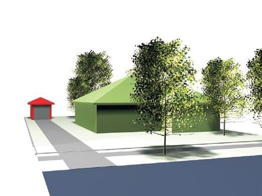
Provideanuncoveredpavedareaatthefront(subjecttostreetscape
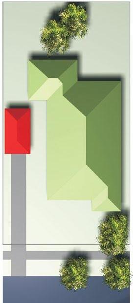

Development Control Plan Part B General Controls CITY OF CANADA BAY Page B-16 Street
considerations.Considerimpactofanynewkerbcrossing.
Street
Illustration5.32 Locationatthefrontconsistingofanopenpaved area ©www. 2009| integratedsolutions.com.au design
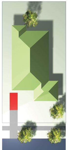
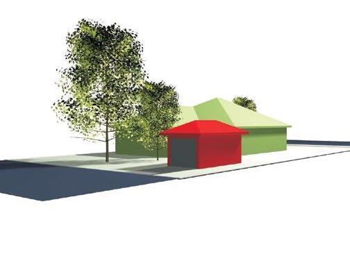
Illustration5.33 Locationatthesidebehindthefrontalignment ©www. 2009| integratedsolutions.com.au design
Locatecarportatthesideofhouse,wellsetbackfromthefront buildingline.Considerimpactofanynewkerbcrossing.
Figure B3.1 Location of car parking at the front consisting of an open paved area
Figure B3.2 Location of car parking at the side behind the front alignment
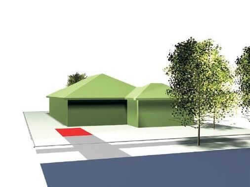
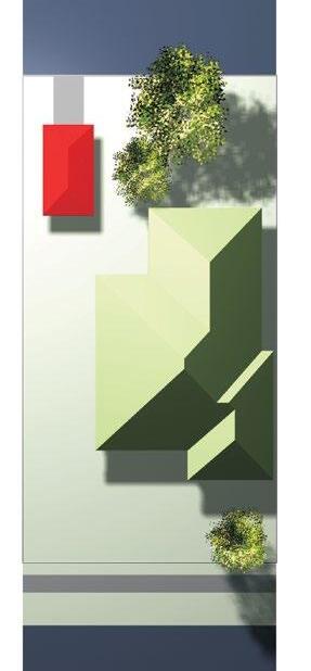
Locateoffstreetparkingattherearwithaccessfromthe street.Considerimpactofanynewkerbcrossing.
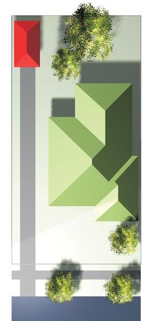
Development Control Plan Part B General Controls CITY OF CANADA BAY Page B-17 Lane Way Street
Street
Illustration5.34 Locationofcarparkingattherearofthesite withaccessfromarearlane ©www. 2009| integratedsolutions.com.au design
Illustration5.35 Locationofcarparkingattherearofasitewith accessfromstreetfrontage ©www. 2009| integratedsolutions.com.au design
Figure B3.3 Location of car parking at the rear of the site with access from a rear lane
Figure B3.4 Location of car parking at the rear of the site with access from street frontage
B3.3 Multi-dwelling housing, multi dwelling housing (terraces), manor houses and residential flat buildings.
Car spaces
Controls
C1. For existing and new development the location of a garage or carport, in order of high to low priority, is to be:
a) Located in a basement with access from a rear lane;
b) Located at the rear of the site with access from a rear lane;
c) Located in a basement with access from the street frontage;
d) Located at the rear of the site with access from the street frontage; and
e) Located at the side of the development, behind the front building alignment.
C2. All multi unit development and residential flat buildings should ensure that all vehicle parking is behind the building line and arranged so that all vehicles may be driven in a forward direction during both ingress and egress from the site.
C3. Car Share schemes, carpark decoupling and the like should be utilised wherever possible to reduce the amount of on-site carparking.
Development Control Plan Part B General Controls CITY OF CANADA BAY Page B-18
B3.4 Car Parking Rates
Residential parking requirements - Dwelling houses, Semi-detached dwellings, Dual occupancies and Secondary dwellings.
Table B-B
Residential parking requirements (low density) - Dwelling houses, Semi-detached dwellings, Dual occupancies and Secondary dwellings.
The following parking rates apply to any dwelling houses, semi-detached dwellings, dual occupancies or secondary dwellings.
Table B-B
Residential Parking Requirements Additional Information
1. Any parking in excess of the above requirements will be counted as Gross Floor Area (GFA) (refer to definition in Canada Bay LEP).
Residential parking requirements - Residential flat buildings, Manor houses, Multi dwelling housing, Multi dwelling housing (terraces) and Shop top housing
Table B-C
Residential parking requirements (medium/high density) - Residential flat buildings, Manor houses, Multi dwelling housing, Multi dwelling housing (terraces) and Shop top housing
Residential Parking Category A
The following parking rates apply to any residential flat buildings, manor houses, multi dwelling housing, multi dwelling housing (terraces) or shop top housing on any land parcel wholly or partly located within Category A on the Residential Car Parking Rates Map.
Note: Category A generally applies to residential development located within the following areas that are not within Category B: •
Development Control Plan Part B General Controls CITY OF CANADA BAY Page B-19
Dwelling type Car parking spaces required per dwelling Minimum Maximum Dwelling house 1 2 Semi-detached dwelling 1 1 Dual occupancy 1 1 Secondary dwelling 0 0
Resident parking Number of bedrooms per dwelling Maximum number of car parking spaces 0 - 1 1 2 1 3 1.5 4 + 2 Visitor parking Number of dwellings Maximum number of car parking spaces Any 1 space per 5 dwellings
Neighbourhood
zone
B1
Centre
Enterprise Corridor zone
R1 General Residential zone
R3 Medium Density Residential zone
R4 High Density Residential zone
• B6
•
•
•
Residential Parking Category B
The following parking rates apply to any residential flat buildings, manor houses, multi dwelling housing, multi dwelling housing (terraces) or shop top housing on any land parcel wholly or partly located within Category B on the Residential Car Parking Rates Map.
Note: Category B generally applies to residential development located within the following areas:
• B4 Mixed Use zone
• Within 400m of a B4 Mixed Use zone
• B3 Commercial Core zone
• Within 400m of a B3 Commercial Core zone
• Within 800m of a railway or metro station
Residential Parking Category C
The following parking rates apply to any residential flat buildings, manor houses, multi dwelling housing, multi dwelling housing (terraces) or shop top housing on any land parcel wholly or partly located within Category C on the Residential Car Parking Rates Map.
Note: Category C generally applies to residential development located within the following areas:
• Parramatta Road Corridor Urban Transformation Strategy Stage 1 Implementation Area
Development Control Plan Part B General Controls CITY OF CANADA BAY Page B-20
Resident Parking Number of bedrooms per dwelling Maximum number of car parking spaces 0 - 1 0.6 2 0.9 3 1.4 Visitor Parking Number of dwellings Maximum number of car parking spaces 0 - 4 0 5-9 1 10+ 1 per 5 dwellings
Resident parking Number of bedrooms per dwelling Maximum number of car parking spaces Studio 0.3 1 0.5 2 0.9 3 1.2 Visitor parking Number of dwellings Maximum number of car parking spaces Any 0.1 space per 5 dwellings
Residential Parking Category D
The following parking rates apply to any residential flat buildings, multi dwelling housing or shop top housing on any land parcel wholly or partly located within Category D on the Residential (Medium/High Density) Car Parking Rates Map.
Note: Category D generally applies to residential development located within the following areas:
• Rhodes West and Rhodes East
Table B-C Residential Parking Requirements Additional Information
1) Any parking in excess of the above requirements will be counted as Gross Floor Area (GFA) (refer to definition in Canada Bay LEP).
2) In calculating the total number of car parking spaces required for a development, the total should:
a) Be rounded up if the fraction of the total calculation is equal or more than half (0.5 of a space); and
b) Include a room that is capable of being converted to a bedroom (it has a minimum internal area of 12sqm and includes a window).
3) Refer to Residential (Medium/High Density) Car Parking Rates Map (Figure B3.5 to Figure B3.11) to understand where the above car parking requirements apply.
4) If a site falls within Category C and also Category A or B then the Category C parking requirements will prevail.
5) If a site falls within Category D and also Category A or B then the Category D parking requirements will prevail.
6) If there is a discrepancy between Category C and the Parramatta Road Corridor Urban Transformation Strategy then the Parramatta Road Corridor Urban Transformation Strategy parking requirements will prevail.
Development Control Plan Part B General Controls CITY OF CANADA BAY Page B-21
Resident parking Number of bedrooms per dwelling Maximum number of car parking spaces Studio 0.1 1 0.3 2 0.7 3 + 1 Visitor parking Number of dwellings Maximum number of car parking spaces Any 1 space per 20 dwellings
C a t e g o r y A C a t e g o r y B C a t e g o r y C C a t e g o r y D T h i s p a r k i n g m a p a p p e s o a

t e r a c e s ) a n d s h o p
d w e n g h o u s n g
o p h o u s n g
m e d i u m a n d h g h d e n s t y r e s d e n t a d e v e l o p m e n t s n c u d n g e s d e n t a f l a b u l d n g s m a n o r h o u s e s , m u t d w e n g h o u s n g m u t B3.5
Figure
Development Control Plan Part B General Controls CITY OF CANADA BAY Page B-22 C a d a s r e 1 5 0 2 / 2 0 2 2 © S p a a S e r v c e s
P o e c o n G D A 1 9 9 4 M G A Z o n e 5 6
S c a e 1 1 0 0 0 0 @ A 3
C i t y o f C a n a d a B a y D e v e l o p m e n t C o n t r o l P l a n
R e s i d e n t i a l C a r P a r k i n g R a t e s M a p S h e e t R C P 0 0 1
Residential Car Parking Rates mapSheet 1
m e d i u m a n d h g h d e n s t y r e s d e n t a d e v e o p m e n s n c u d i n g e s d e n t a f a b u i d n g s , m a n o r h o u s e s , m u l
d w e n g h o u s i n g m u t
o p h o u s n g
d w e i n g h o u s n g ( e r r a c e s ) a n d s h o p
Development Control Plan Part B General Controls CITY OF CANADA BAY Page B-23 C a d a s t e 1 5 0 2 2 0 2 2 © S p a i a S e r v c e s C
o f C a n a d a B a y D e v e l o p m e n t C o n t r o l P l a n P o e c o n G D A 1 9 9 4 M G A Z o n e 5 6 R
C a
P a
k n g R a t e s M a p S
R C P 0 0 2 S c a e 1 1 0 0 0 0 @ A 3 C
i t y
e s d e n t i a l
r
r Figure B3.6 Residential Car Parking Rates mapSheet 2
h e e t
a e g o r y A C a e g o r y B C a e g o r y C C a e g o r y D T h s p a r k n g m a p a p p i e s o a
t e r a c e s ) a n d s h o p
d w e n g h o u s n g
o p h o u s n g
m e d i u m a n d h g h d e n s t y r e s d e n t a d e v e l o p m e n t s n c u d n g e s d e n t a f l a b u l d n g s m a n o r h o u s e s , m u t d w e n g h o u s n g m u t B3.7
Figure
Development Control Plan Part B General Controls CITY OF CANADA BAY Page B-24 C a d a s r e 1 5 0 2 / 2 0 2 2 © S p a a S e r v c e s
P o e c o n G D A 1 9 9 4 M G A Z o n e 5 6
S c a e 1 1 0 0 0 0 @ A 3
C i t y o f C a n a d a B a y D e v e l o p m e n t C o n t r o l P l a n
R e s i d e n t i a l C a r P a r k i n g R a t e s M a p S h e e t R C P 0 0 3
C a t e g o r y A C a t e g o r y B C a t e g o r y C C a t e g o r y D T h i s p a r k i n g m a p a p p e s o a
Residential Car Parking Rates mapSheet 3
A Residential Car Parking Rates mapSheet 4
C a e g o r y B C a e g o r y C C a e g o r y D T h s p a r k n g m a p a p p i e s o a m e d i u m a n d h g h d e n s t y r e s d e n t a d e v e o p m e n s n c u d i n g e s d e n t a f a b u i d n g s , m a n o r h o u s e s , m u l d w e n g h o u s i n g m u t
o p h o u s n g
Development Control Plan Part B General Controls CITY OF CANADA BAY Page B-25 C a d a s t e 1 5 0 2 2 0 2 2 © S p a i a S e r v c e s C i t y o f C a n a d a B a y D e v e l o p m e n t C o n t r o l P l a n P o e c o n G D A 1 9 9 4 M G A Z o n e 5 6 R e
i a l C a r P a r k n g R a t e s M a p S h e e t R C P 0 0 4 S c a e 1 1 0 0 0 0 @ A 3 C
s d e n t
a e g o r y Figure B3.8
d w e i n g h o u s n g ( e r r a c e s ) a n d s h o p
t e r a c e s ) a n d s h o p
m e d i u m a n d h g h d e n s t y r e s d e n t a d e v e l o p m e n t s n c u d n g e s d e n t a f l a b u l d n g s m a n o r h o u s e s , m u t d w e n g h o u s n g m u t
o p h o u s n g
d w e n g h o u s n g
Figure
Development Control Plan Part B General Controls CITY OF CANADA BAY Page B-26 C a d a s r e 1 5 0 2 / 2 0 2 2 © S p a a S e r v c e s
C
P o e c o n G D A 1 9 9 4 M G A Z o n e 5 6
S c a e 1 1 0 0 0 0 @ A 3
C i t y o f
a n a d a B a y D e v e l o p m e n t C o n t r o l P l a n
R e s i d e n t i a l C a r P a r k i n g R a t e s M a p S h e e t R C P 0 0 5
C a t e g o r y A C a t e g o r y B C a t e g o r y C C a t e g o r y D T h i s p a r k i n g m a p a p p e s o a B3.9
Residential Car Parking Rates mapSheet 5
m e d i u m a n d h g h d e n s t y r e s d e n t a d e v e o p m e n s n c u d i n g e s d e n t a f a b u i d n g s , m a n o r h o u s e s , m u l
d w e n g h o u s i n g m u t
o p h o u s n g
d w e i n g h o u s n g ( e r r a c e s ) a n d s h o p
Development Control Plan Part B General Controls CITY OF CANADA BAY Page B-27 C a d a s t e 1 5 0 2 2 0 2 2 © S p a i a S e r v c e s C
o f C a n a d a B a y D e v e l o p m e n t C o n t r o l P l a n P o e c o n G D A 1 9 9 4 M G A Z o n e 5 6 R
C a
P a
k n g R a t e s M a p S
R C P 0 0 6 S c a e 1 1 0 0 0 0 @ A 3 C
i t y
e s d e n t i a l
r
r Figure B3.10 Residential Car Parking Rates mapSheet 6
h e e t
a e g o r y A C a e g o r y B C a e g o r y C C a e g o r y D T h s p a r k n g m a p a p p i e s o a
C a t e g o r y A C a t e g o r y B C a t e g o r y C C a t e g o r y D T h i s p a r k i n g m a p a p p e s o a
t e r a c e s ) a n d s h o p
m e d i u m a n d h g h d e n s t y r e s d e n t a d e v e l o p m e n t s n c u d n g e s d e n t a f l a b u l d n g s m a n o r h o u s e s , m u t d w e n g h o u s n g m u t
o p h o u s n g
d w e n g h o u s n g
Development Control Plan Part B General Controls CITY OF CANADA BAY Page B-28 C a d a s r e 1 5 0 2 / 2 0 2 0 © S p a a S e r v c e s
P o e c o n G D A 1 9 9 4 M G A Z o n e 5 6
S c a e 1 1 0 0 0 0 @ A 3
C i t y o f C a n a d a B a y D e v e l o p m e n t C o n t r o l P l a n
R e s i d e n t i a l C a r P a r k i n g R a t e s M a p S h e e t R C P 0 0 7
Figure B3.11 Residential Car Parking Rates mapSheet 7
Table B-D Accessible Parking Requirements
BCA Classification of the building to which the parking is associated
Class 3
Boarding houses, guest houses, hostel, backpackers accommodation, or the residential part of a hotel or motel
Minimum parking requirements
(Table D3.5 of the BCA)
To be calculated by multiplying the total number of car parking spaces by the:
a) Percentage of accessible sole-occupancy units to the total number of sole-occupancy units; or
b) Percentage of beds to which access for people with disabilities is provided to the total number of beds provided.
The calculated number to be taken to the next whole figure.
1 space for every 100 car parking spaces or part thereof
Class 5, 7, 8 and 9c
Class 6
a) up to 1000 car parking spaces; and
b) for each additional 100 car parking spaces or part thereof in excess of 1000 car parking spaces
Class 9a
(a) Hospital (non-outpatient area)
(b) Hospital (outpatient area)
up to 1000 car parking spaces; and
for each additional 100 car parking spaces or part thereof in excess of 1000 car parking spaces
Nursing home
1 space for every 100 car parking spaces or part thereof
1 space for every 50 car parking spaces or part thereof
1 space
1 space for every 100 car parking spaces or part thereof
1 space for every 50 car parking spaces or part thereof
1 space
1 space for every 100 car parking spaces or part thereof
1 space for every 100 car parking spaces or part thereof Class 9b
Clinic or day surgery not forming part of a hospital
(a) School
(b) Other assembly buildings
up to 1000 car parking spaces; and
for each additional 100 car parking spaces or part thereof in excess of 1000 car parking spaces
1 space for every 100 car parking spaces or part thereof
1 space for every 50 car parking spaces or part thereof
1 space
Source: Based on Transport for NSW Guide to Traffic Generating Developments 2002
Development Control Plan Part B General Controls CITY OF CANADA BAY Page B-29
Table B-E Parking Requirements: Development in mixed use areas and Neighbourhood Centres
Land use
Accommodation
Motels
Minimum parking requirements
1 space for each unit +1 space per 2 employees
if restaurant included then add the greater of:
• 15 spaces per 100m2 GFA of restaurant/function room, or
• 1 space per 3 seats
Hotels
Office and Business Office Premises
Business Premises
Retail Shops
Service stations and convenience stores
Comparisons should be drawn with similar developments
1 space per 40m2 GFA
1 space per 40m2 GFA
1 space per 40m2 GLFA
Requirements are additive:
• 6 spaces per work bay
• 5 spaces per 100m2 GFA of convenience store
If restaurant present, the greater of:
• 15 spaces per 100m2 GFA, or 1 space per 3 seats
Drive-in take-away food outlets
Developments with no on-site seating: 12 spaces per 100m2 GFA
Developments with on-site seating: 12 spaces per 100m2 GFA or greater of:
• 1 space per 5 seats (internal and external), or
• 1 space per 2 seats (internal)
Developments with on-site seating and drive through facilities greater of:
• 1 space per 2 seats (internal), or
• 1 space per 3 seats (internal and external), plus queuing area for 5-12 cars
Restaurants, Cafes, Take-away food & drink premises
Whichever is the greater of:
• 1 space per 6m² of serviced area, or
• 1 space per 4 seats.
A parking free threshold of 20 seats and 30m2 serviced area shall apply to all restaurants, cafes & take-away food and drink premises (to which this DCP applies) in B1 Neighbourhood Centre and B4 Mixed Use zones, excluding those in the areas listed below.
A parking free threshold of 40 seats and 60m2 serviced area shall apply to restaurants in the following (commercial centres) B1 Neighbourhood Centre and B4 Mixed Use zones:
• Victoria Road, Drummoyne (inc. Lyons Rd to Bayswater Street)
• Great North Road, Five Dock (excluding Wareemba/ Abbotsford)
• Majors Bay Road, Concord
• Parramatta Road, Concord (No B1 or B4 on Parramatta Rd)
• Parramatta Road, Five Dock (No B1 or B4 on Parramatta Rd)
• Concord Road, Concord West
• Concord Road, North Strathfield
*Where variation to the above criteria is sought, refer to Additional Criteria below.
Development Control Plan Part B General Controls CITY OF CANADA BAY Page B-30
Land use
Minimum parking requirements
Footpath Dining Nil.
Residential
Car tyre retail outlets
As per Table B-B
Whichever is the greater of:
• 3 spaces per 100m2 GFA, or
• 3 spaces per work bay
Roadside stalls
Markets
Video Stores
Pub
Vehicle Showrooms
Drive-in liquor stores
Plant nurseries
4 spaces
2.5 spaces per stall (customers only)
6.1 spaces per 100m2 GFA
Comparisons should be drawn with similar developments
0.75 spaces per 100m2 site area + 6 spaces per work bay (for vehicle servicing facilities
Comparisons should be drawn with similar developments
Whichever is greater of:
• 15 spaces, or
• 0.5 spaces per 100m2 of site area
Recreational and Tourist Facilities
Recreational facilities
• Squash courts
• Tennis courts
• Bowling alleys
• Bowling greens
• Gymnasiums
Marinas
3 spaces per court
3 spaces per court
3 spaces per alley
30 spaces for first green + 15 spaces for each additional green
7.5 spaces per 100m2 GFA (desirable)
4.5 spaces per 100m2 GFA (minimum)
If a survey of a similar existing development has not been undertaken, the following figures may serve as a general guide:
• 0.6 spaces per wet berth
• 0.2 spaces per dry storage berth
• 0.2 spaces per swing mooring
• 0.5 spaces per marina employee
Health and Community Services
Health consulting rooms and Medical centres
Child care centres
Hospitals
Comparisons should be drawn with similar development
1 space for every 4 children in attendance
Comparisons should be drawn with similar developments
Source: Based on Transport for NSW Guide to Traffic Generating Developments 2002
Development Control Plan Part B General Controls CITY OF CANADA BAY Page B-31
Note:
1) Parking spaces, unless stipulated otherwise, are for cars and depending on land use type, parking for delivery/service vehicles, courier vehicles and bicycles should also be provided.
2) Parking free threshold: means an area expressed in both number of seats and serviced area up to which on-site parking does not need to be provided. The standard parking rate applies to any area and seats in excess of the threshold.
3) Serviced area: means the physical area within the restaurant or café which is accessible to the public, but excluding toilets and corridors. Areas such as the kitchen, or behind counters, or display areas should not be included as serviced area.
4) To calculate car parking requirements, applicants must establish the number of spaces required by the proposed development calculated from Tables C-B to C-E in Part C3. The threshold can then be subtracted from this figure and the balance provided.
5) Where an applicable parking rate has not been provided in the parking requirements tables, a comparison should be drawn with similar developments.
6) Additional Criteria - Restaurants & Cafes
In exceptional circumstances, Council may allow a variation to these requirements where it is demonstrated by the applicant that the proposed use would not have any adverse impacts on the surrounding residential amenity in relation to car parking availability.
To achieve this variation for Restaurants and Cafes, the following criteria would need to be demonstrated to the satisfaction of Council:
A Parking Impact Study prepared by a qualified traffic consultant shall be provided by the applicant, which demonstrates that the shortfall of parking spaces created by the application is able to be accommodated within 200m walking distance of the subject site. The Parking Impact Study would need to provide the following:
a) Total number of available spaces within 200m of the subject site;
b) Parking availability within the study area over operating hours (including hours open for staff and customers);
c) Demonstrate how the parking shortfall of the proposal can be satisfied by the available parking spaces identified in parts (a) and (b) above.
d) Demonstrate that the amenity of the surrounding residential areas would not be adversely impacted by any additional on-street parking.
Note: Within the Study, the applicant may demonstrate alternative options as to how the proposed use/ development mitigates potential impacts of additional car parking requirements. An example of how this may be achieved includes:
• Demonstrating that parking facilities associated with alternative time-of-day uses can be utilised for the use of the restaurant/café customers.
Table B-F Parking Requirements: Development in Industrial Areas
1.3 spaces per 100m2 GFA
1.5 spaces per 100m2 of total GLA.
1.8 spaces per 100m2 gross leasable office/showroom area plus 1.2 spaces per 100m2 of gross leasable factory/warehouse area (where information on components of development is available).
Bulky goods retail stores
Road Transport Facilities
Comparisons should be drawn with similar development
Road Transport Terminals Surveys should be undertaken of similar developments
Container depots Surveys should be undertaken of similar developments
Truck stops 1 truck parking space per motel unit + 1 car space per 2 employees
For restaurant facilities, the greater of:
• 15 spaces per 100m2 GFA, or
• 1 space per 3 seats Other Caravan parks
1 space per caravan site
Source: Based on Transport for NSW Guide to Traffic Generating Developments 2002
Development Control Plan Part B General Controls CITY OF CANADA BAY Page B-32
Industry
Land use Parking requirements
Factories
Warehouses
B3.5 Special Precincts
Breakfast Point Controls
C1. Project Applications for developments involving uses other than those listed in the table below are to be accompanied by a report prepared by a suitably qualified person addressing traffic and parking issues.
C2. Unless otherwise approved by Council, carparking provision is to be as per the table below:
Use Provision
Single Family Dwelling or Attached Dwelling
Townhouse/ Apartment
3 or more bedrooms
Townhouse/ Apartment
2 bedrooms
2 spaces garaged
2 spaces garaged
1.5 space
1 space garaged
(note: 0.5 space garaged and available for allocation to specific unit)
Breakfast Point single dwellings
Vehicle Access
O1. To minimise impact of traffic generated by new development at Breakfast Point on existing residential streets.
O2. To contain vehicle access to the rear of properties where possible.
O3. To minimise the visual impact of garage structures on the street.
Controls
C3. All vehicle access to lots is to be from the rear lanes provided.
C4. No vehicle access is permitted from Brays Road, Bishop Street, Medora Street, Adams Street and Adams Lane.
Garages
O4. To ensure residents parked cars do not dominate the streetscape.
O5. To ensure motor vehicle, home repair, maintenance and hobby activities can occur without impacting on neighbourhood amenity.
Apartment 1 bedroom
Residential Visitors
1 space garaged
1 space per 5 dwellings (note: on-street within 100m of dwellings served, or off-street if insufficient space available on street)
O6. To ensure car parking facilities and access are fully integrated into the house design and streetscape visual character.
Shops
Offices
1 space per 20m2 GFA
1 space per 40m2 GFA
Note: applications for developments involving uses other than those listed above are to be accompanied by a report prepared by a suitably qualified person addressing traffic and parking issues.
O7. To ensure garaging of vehicles does not become a dominant or detrimental element in the visual streetscape.
Controls
C5. Kerb cross-overs and driveways to open access ways are not to exceed 3.6m in width.
C6. Each dwelling is to have an attached or approved freestanding garage capable of accommodating 2 cars, designed to fully integrate with the dwelling.
C7. Garage structures shall not exceed 7.0m in width.
C8. Open carports are not permitted.
Development Control Plan Part B General Controls CITY OF CANADA BAY Page B-33
Driveways and Kerb Cross-Overs
O8. To ensure a consistent visual standard in the street-scape.
O9. To ensure landscaped nature strip is predominant in the visual environment of the street.
O10. To ensure comfortable, safe and convenient access to allotments.
Controls
C9. Kerb cross-overs and driveways in rear access laneways shall not exceed 6 metres in width.
C10. Within an allotment, driveway gradients are not to exceed 1 in 5 and are to have a transition gradient of no greater than 1 in 15 for a distance of 2.5m at each end.
C11. Cross over construction is to be to Council standards.
Concord West
Controls
C12. Car and bicycle provision is to be in accordance with Table B-C.
C13. Car parking provision must not exceed individual maximums provided per Sub-precinct in Table B-H Concord West Maximum Car Parking Provisions per Sub-precinct.
Table B-G Concord West Maximum Car Parking Rates
Category Other (max. spaces/m2 GFA)
Commercial Retail Industrial
Homebush Precinct 100 70 120
45)
Table
Provisions per Sub-precinct
Sub-precinct No. of Car Parking Spaces
2 86
3 20
5 157 6 141
7 126
Rhodes West Controls
C14. To achieve a high quality public domain, at grade car parking is only permitted to the rear of shops, restaurants and the like, and to detached, pair and row housing. It must be located behind the building line and screened from the public domain unless accessed via a lane or private street.
C15. To achieve a high quality public domain, internal car parking which protrudes more than 1.2m above ground level of the adjacent public domain must be located behind the building alignment and be screened from the public domain in a manner that is an integral part of the external design of the building.
Development Control Plan Part B General Controls CITY OF CANADA BAY Page B-34
(Extract of Table 3.2 Paramatta Road Corridor Urban Transformation Strategy, Planning and Design Guidelines, Nov 2016, Page
B-H Concord West Maximum Car Parking
B3.6 Bicycle parking and storage facilities
Objectives
O1. To encourage the use of bicycles by residents, employees and visitors of Canada Bay for recreational use and as an alternative mode of transport.
O2. To ensure bicycle parking and storage facilities are located in a safe location.
O3. To ensure bicycle parking and storage facilities can be used to securely store bicycles.
O4. To ensure bicycle parking and storage facilities are designed and located to provide easy, convenient and safe access to buildings.
O5. To ensure bicycle parking and storage facilities are designed and located to minimise conflict with pedestrians and other traffic.
O6. To ensure that bicycle storage and parking facilities are provided at end of trip for cyclists.
Controls
C1. Bicycle parking and storage facilities should be provided to allow parking or storage of a minimum number of bicycles, in accordance with Table B-I.
C2. Bicycle parking must be made available to customers and staff and conveniently located.
C3. Bicycle storage facilities may be provided as fully enclosed individual lockers (referred to in AS 2890.3 as Class 1 facilities) or as locked compounds (referred to in AS 2890.3 as Class 2 facilities), depending on the type of development and practicality of access to the facility.
A private garage is deemed to be the equivalent of an individual locker space.
Compounds should be fitted with a sufficient number of devices to which stored bicycles can be secured (referred to in AS 2890.3 as Class 3 facilities).
C4. Bicycle storage facilities should be covered to provide weather protection.
C5. Showers and lockers (end of trip facilities) should be provided close to secure bicycle storage facilities within new commercial and industrial developments (refer to End of trip facilities for more information).
C6. Bicycle storage facilities should generally be designed in accordance with paragraph 2.2 of AS 2890.3.
C7. Bicycle parking facilities must be located so that the minimum clearance (for a pedestrian pass) between a parked bicycle and any other obstruction is 1200mm.
C8. Bicycle parking facilities should generally be designed in accordance with figure B3 in AS 2890.3. The provision of weather protection for bicycle parking is encouraged.
C9. Access paths to bicycle storage or parking facilities must be provided so that the envelope shown in figure 3.1 in AS 2890.3 will fit when projected along the access path.
C10. Where an access path to a bicycle storage or parking facility includes stairs, such stairs must include a bicycle wheeling ramp in accordance with figure 7.12 in the Austroads Guide to Traffic Engineering Practice (Part 14 Bicycles). The gradient of the ramp should not exceed 25%.
C11. Unacceptable bicycle parking and storage facilities are facilities where:
a) Only a wheel can be secured but not the bicycle frame;
b) The device does not provide stability for the bicycle and may result in damage to the bicycle; and
c) The device has a slot in the ground which may get dirty and difficult to use over time.
C12. Directional signs advising the public of the location of bicycle parking and storage areas should be harmoniously designed and erected to assist both the facilitation and promotion of the use of these facilities.
C13. To ensure bicycle parking and storage facilities are located in a safe location that is well lit with minimal concealment spaces.
Development Control Plan Part B General Controls CITY OF CANADA BAY Page B-35
Note:
1) For all residential, commercial and industrial development, fractions should be rounded up in the calculation of the required number of spaces.
2) Council may waive the requirement for bicycle storage facilities for other non-residential development if it is satisfied that the requirement presents an unreasonable burden on the development.
3) The above requirements only apply to new developments or where substantial alterations and additions are proposed.
4) Where the table does not provide a standard, the Council will make an assessment of the required number of spaces based on:
a) Expected number of employees, and their likely or desired use of bicycles for travel to and from work; and
b) Expected number of visitors, and their likely or desired use of bicycles to visit the development.
5) Bicycle parking and storage provisions are in addition to any other parking and storage requirements.
6) If different rates are provided elsewhere within this DCP then those rates will prevail for that specified location.
B3.7 End of trip facilities Objectives
O1. To encourage cycling as a highly convenient transport mode by providing easily accessible and secure parking and end-of-trip facilities.
O2. To reduce car-usage and reliance, promote sustainability and a more active, healthy lifestyle.
C1. End of trip facilities in non-residential developments are to be provided in accordance with Table B-J.
C2. Consideration should be given to the provision of fully serviced end of trip facilities such as showers, changerooms and daily laundry (including supplying laundered towels, detergents, irons and ironing boards, hair dryers, toiletries, and the like).
C3. End of trip facilities must be publicly available and conveniently located.
Development Control Plan Part B General Controls CITY OF CANADA BAY Page B-36
Land Use Resident/Staff Bicycle storage facility Visitor Bicycle parking facility Residential 2 per dwelling 2 per 10 dwellings Commercial 2 per 150m2 GFA 2 per 400m2 GFA Retail 2 per 250m2 GFA 2 per unit + 2 per 100m2 GFA Industrial 2 per 10 employees 2 per unit +2 per 100m2 GFA
Table B-I Minimum bicycle parking and storage provisions
Controls
Personal lockers Showers, change cubicles and lockers 20 bicycle spaces Each 20 additional bicycle spaces 1 per bicycle space 2 2
Table B-J Minimum end of trip facility provisions
B3.8 Electric Vehicles Objectives
O1. To provide facilities for charging of electric vehicles to meet current and future needs.
O2. To accommodate hybrid and electric vehicles by ensuring that adequate charging points for these vehicles are provided in off-street private and public car parking areas.
Controls
C1. Level 1 electric vehicle charging facilities must be provided in accordance with Table B-K:
C2. Level 2 electric vehicle charging facilities must be provided in accordance with Table B-L:
Note: If Level 2 facilities are required they are to be provided in addition to any Level 1 requirements.
C3. Shared facilities must be accessible to anyone who has legal access to the building.
C4. All electric charging points in common property or visitor parking areas are to have clear signage identifying:
a) Location; and
b) Fees and charges, if any.
C5. Electric circuitry to accommodate ‘Level 2’ electric vehicle charging points must be integrated into all off-street car parking of new residential and non-residential development to ensure that all car spaces can install electric vehicle charging points in the future. This must include:
a) Ensuring adequate electrical capacity and infrastructure (cable size, distribution board size etc.) for the electric vehicle charging point system; and
b) Providing either buried cables underground or cable trays sufficient to accommodate electric circuitry to each car space; and
c) Slow, single phase 7kW electrical circuitry for private car spaces; and
d) Fast, three-phase 11kW – 22kW electrical circuitry for publicly available spaces.
Note: Circuitry requirements for all off-street parking spaces are in addition to minimum charging point requirements in Table B-K and Table B-L.
C6. The installation of a Level 2 electric vehicle charging points is encouraged for new dwelling houses, dual occupancies and semi-detached dwellings.
Development Control Plan Part B General Controls CITY OF CANADA BAY Page B-37
Table B-K
Minimum Level 1 electric vehicle charging facility requirements
Dwelling houses, dual occupancies, semidetached dwellings
Level 1
• Regular 240V wall socket (10amps).
• 2.4kW - 3.7kW.
• No specialist installation required.
• 16 – 20 hours to fully charge average vehicle.
Secondary dwelling Level 1
• Regular 240V wall socket (10amps).
• 2.4kW - 3.7kW.
• No specialist installation required.
• 16 – 20 hours to fully charge average vehicle.
1 per parking space
Manor houses, Multidwelling housing, Multi-dwelling housing (terraces), Residential flat building, Shop top housing
Level 1
• Regular 240V wall socket (10amps).
• 2.4kW - 3.7kW.
• No specialist installation required.
• 16 – 20 hours to fully charge average vehicle.
Non-residential Level 1
• Level 1 Regular 240V wall socket (10amps).
• 2.4kW - 3.7kW.
• No specialist installation required.
• 16 – 20 hours to fully charge average vehicle.
1 per parking space (if parking is provided)
1 per parking space
1 per five bicycle parking spaces (a dedicated space and charging point for electric bicycles and mobility scooters to be charged must be provided for every five bicycle parking spaces)
1 per parking space
Table B-L Minimum Level 2 electric vehicle charging facility requirements
Manor houses, Multidwelling housing, Multidwelling housing (terraces), Residential flat building, Shop top housing
Level 2 AC
• Directly wired into a dedicated circuit (16amp – 40amp).
• 7kW – 22kW.
• Level 2 provides between 18km to 110km of charge per hour.
• Total charge time of between 4 – 12 hours depending on the vehicle.
Non-residential Level 2 AC
• Directly wired into a dedicated circuit (16amp – 40amp).
• 7kW – 22kW.
• Level 2 provides between 18km to 110km of charge per hour.
• Total charge time of between 4 – 12 hours depending on the vehicle.
Private spaces
• A charging point in 1 car parking space or 10% of all car parking spaces, whichever is greater.
Public spaces
• 1 shared facility for developments with 5-10 dwellings
• 1 additional shared facility for every additional 10 dwellings or part thereof.
• To be provided in common or visitor parking areas.
A charging point in 1 car parking space or 10% of all car parking spaces, whichever is greater.
Development Control Plan Part B General Controls CITY OF CANADA BAY Page B-38
Type of development Type of charging facility Minimum number of charging points/facilities/stations
Type of development Type of charging facility Minimum number of charging
points/facilities/stations
B3.9 Common loading docks and service vehicle parking
Objectives
O1. To provide common loading docks and parking for the receiving of home deliveries and the parking of service vehicles (trades etc.) and removalist trucks in new commercial and medium/high density residential developments.
Controls
C1. Separate parking spaces for service vehicles are to be provided in new developments in accordance with the minimum requirements detailed in Table B-M.
Note: Service vehicle parking spaces are in addition to any requirements for access, parking or storage specified in DCP Waste Management section.
C2. Service vehicle parking spaces are not to be shared with parking provided for any other purpose.
C3. For mixed use developments, the total number of service vehicle spaces is to be calculated on a pro rata basis of spaces required for the relative proportions of different uses within the building.
C4. Service vehicle parking spaces, including spaces for bike couriers are to be:
a) located near vehicle entry points and near lifts;
b) clearly designated and signposted for service vehicles only;
c) screened from the street where possible; and
d) located completely within the boundary of the site, clear of parked vehicles; and clear of through traffic.
C5. Parking spaces for service vehicles are not to be used for other purposes such as storage of goods and equipment.
C6. The total requirement identified in Table B-M may be reduced for developments with a gross floor area in excess of 50,000sqm where it can be demonstrated to the satisfaction of the consent authority that:
a) the proposed uses are complementary in terms of servicing demand; and
b) at least one space per tenancy for business owners is provided.
C7. All service vehicle parking spaces must be designed in accordance with AS 2890.2:2018 Parking facilities – Off-street commercial vehicle facilities. These spaces must be large enough for at least a medium rigid vehicle (8.8m) to accommodate removalist trucks.
Land use
Residential
Commercial
Service Vehicle Parking Requirements
1 space for the first 50 dwellings or serviced apartments; plus
0.5 spaces for every 50 dwellings/serviced apartments or part thereafter
1 space per 3,300sqm GFA, or part thereof, for the first 50,000sqm; plus
1 space per 6,600sqm, or part thereof, for additional floor area over 50,000sqm and under 100,000sqm; plus
1 space per 13,200sqm, or part thereof, for additional floor area over 100,000sqm
Shops, shopping centres
Hotels
1 space per 350sqm GFA, or part thereof, up to 2,000sqm; then
1 space per 8,00sqm GFA thereafter
1 space per 50 hotel bedrooms, or part thereof, up to 100 bedrooms; then
1 space per 100 hotel bedrooms; plus 1 space per 400sqm of reception, lounge, bar and restaurant area GFA, or part thereof, for the first 2,000sqm; then
1 space per 8000sqm of reception, lounge, bar and restaurant area GFA thereafter.
Industry, warehouse, distribution centre
Other
1 space per 700sqm GFA, or part thereof
1 space for 1,750sqm GFA, or part thereof, or to meet needs.
Development Control Plan Part B General Controls CITY OF CANADA BAY Page B-39
Table B-M
B3.10 Car Share
Objectives
O1. To provide car sharing facilities to meet current and future needs.
O2. To reduce car usage and reliance.
Controls
C1. Car sharing facilities must be provided in Rhodes East in accordance with the following table:
Type of development
Multi dwelling housing, Residential flat building, Shop top housing
Car share rate to reduce car parking provision
Car share facilities required within 400m or less walking distance to station.
1 per 20 dwellings
N/A
C2. Car share spaces are to be for the exclusive use of car share scheme vehicles.
C3. Car share parking spaces are to be:
a) Exclusive of visitor car parking;
b) Retained as common property of the Owners Corporation of the site and not sold or leased to an individual owner/ occupier at any time;
c) Made available for use by operators of car share schemes;
d) Grouped together in the most convenient locations relative to car parking entrances and pedestrian lifts or access points;
e) Located in well-lit places that allow for casual surveillance; and
f) Signposted for use only by car share vehicles and made known to building occupants and car share members through appropriate signage which indicate the availability of the scheme and promotes its use as an alternative mode of transport.
Car share facilities required if greater than 400m walking distance to station.
1 per 40 dwellings
1 car share space in lieu of 3 private car parking spaces
C4. Development Applications are to demonstrate how the car share parking space(s) is to be accessed, including where access is through a security gate.
C5. A covenant is to be registered with the strata plan advising of any car share parking space. The covenant is to include provisions that the car share parking space(s) cannot be revoked or modified without prior approval of Council.
Development Control Plan Part B General Controls CITY OF CANADA BAY Page B-40
B4 Waste Management
Objectives
O1. Assist in achieving Federal and State Government waste minimisation targets in accordance with regional waste plans.
O2. Minimise overall environmental impacts of waste and foster the principles of ecologically sustainable development (ESD).
O3. Facilitate source separation and provide design standards that complement waste collection and management services offered by Council and private service providers.
O4. Manage waste in accordance with the Waste Hierarchy to:
i) Avoid producing waste in the first place;
ii) Minimise the amount of waste produced;
iii) Re-use waste materials wherever possible;
iv) Recycle once re-use options have been exhausted; and
v) Dispose of what is left, as a last resort, in a responsible way to appropriate waste disposal facilities;
O5. Ensure waste management systems are convenient and safe for residents and waste collection personnel.
B4.1 General Controls Controls
C1. A Waste Management Plan is required as part of the development application documents for all developments.
C2. On site storage for waste and recycling facilities must be provided in designated areas for all new developments. The area should be located so as not to cause offence to adjoining property owners or occupiers with regard to smell, visual appearance, noise disturbance and traffic.
C3. Source separation facilities and containers shall be provided in kitchens for waste to be divided into separate waste streams to encourage the composting and recycling of materials. Space must be allocated and receptacles supplied with the capacity to store at least 2 days’ worth of residual waste, recyclables and food waste.
C4. Common composting facilities should be provided at accessible locations away from dwellings to every residential development for garden waste and organic kitchen waste.
C5. Consideration should be given to bin storage space for garden organics that are not able to be composted on site e.g. thick branches as garden organics cannot be disposed of in Council serviced waste bins.
C6. Source separation facilities shall be provided on building sites so that different waste streams may be easily separated during construction and demolition to encourage the re-use and recycling of materials. The source separation facilities are to be clearly indicated on the drawings. Tipping dockets for disposal and recovery of all wastes are required to be held on site during this phase and are subject to auditing and/or inspection by Council.
Development Control Plan Part B General Controls CITY OF CANADA BAY Page B-41
Avoid and reduce waste Reuse waste Recycle waste Recover energy Treat waste Dispose of waste Most preferable Least preferable Waste Hierarchy diagram
C7. In the design of buildings waste should be minimised by:
• Matching building dimensions to standard sizes of building materials;
• Using recycled materials;
• Selecting materials that can be re-used or recycled in the future; and
• Utilising component parts that may be easily replaced.
C8. Plans and drawings of the proposed development that highlight the location of and space allocated to the waste management facilities and the nominated waste collection point must be included in the Waste Management Plan. The path of access for both users and collection vehicles must also be highlighted.
Understanding Council’s Waste Service
C9. Waste, recycling and garden organics generation rates are provided as minimum requirements:
Waste generation per week
Residential Developments Waste Recycling Garden organics*
Per Premises 120L 120L 120L
*For multi-unit developments, 1 x 240L garden organics bin is to be designated per 10 residential units (rounded up).
C10. Standard space dimensions for residential waste, recycling and garden organic bins:
C11. Collection Vehicle Dimensions
City of Canada Bay and its waste contractors currently use rear-loading, compacting collection vehicles of various capacities for on-site collection. In order to ensure access for both current vehicles, and future-proof allowance for any changes in waste fleet requirements, on-site access is to be designed for a vehicle of the following dimensions (provided for a standard heavy rigid vehicle as identified in Australian Standard 2890.2:2018):
Table B-N
Table 1 Standard dimensions for a HRV from AS 2890.2 Parking Facilities:
Note: Standard dimensions are a guide only and may differ depending on the manufacturer.
Development Control Plan Part B General Controls CITY OF CANADA BAY Page B-42
Height Width Depth 120L 980mm 500mm 540mm 240L 1140mm 580mm 715mm 660L 1200mm 1260mm 780mm 1100L 1330mm 1240mm 1070mm
Off-street Commercial Vehicle Facilities Heavy Rigid Vehicle Dimensions Overall length (m) 12.5 Design width (m) 2.8 Swept circle (m) 27.8 Clearance (travel height) (m) 4.5 Roadway/ramp grade (max) 1:6.5 (15.4%) Rate of change of grade (max) 1:16 (6.25%) in 7.0m of travel Front chassis clearance 13 degrees Rear chassis clearance 16 degrees
B4.2 Single Dwellings and Dual Occupancies Controls
C1. Residential development are to provide storage space for waste, recyclables, and garden organics in accordance with the following:
Allocated 1x 120L Waste Bin (1 per dwelling), 1 x 240L Recycling Bin (1 per dwelling) and 1 x 240L Garden Organics (1 per dwelling).
C2. Space must be allocated within each property boundary behind the building line for storing Council specified waste and recycling bins.
C3. The waste/recycling storage area shall be constructed of brick or other approved masonry material, have a concrete floor at appropriate level approved by Council and be suitably graded to allow drainage.
B4.3 Multi-unit Dwelling Residential Development Controls
C1. Multi-unit accommodation refers to all buildings with three or more dwellings on one lot (whether self-contained or not) and includes the following:
• Attached dwellings
• Boarding houses
• Group homes
• Multi dwelling housing
• Residential flat buildings
• Seniors housing
• Serviced apartments
• Shop top housing
Bin Allocation Controls
C2. Multi-unit dwellings may be permitted to have allocated one set of bins per dwelling, on approval by council, in accordance with the following:
Allocated 1x 120L Waste Bin (1 per dwelling, collected weekly), 1 x 240L Recycling Bin (1 per dwelling, collected fortnightly) and 1 x 240L Garden Organics Bin (1 per dwelling collected fortnightly).
Approval for allocation of one set of bins per dwelling will only be permitted where:
• Each dwelling has direct access at ground level
• Bin storage is provided at each dwelling, and the bin storage location is specified on the application.
• A kerbside presentation point is nominated on the application
• The space required for presentation at kerb does not exceed one-third of the width of the property frontage
• Kerbside collection activity does not create an obstruction of the pathway or roadway or cause an illegal hazard
• Kerbside presentation point is to be located so as to minimise the impacts from noise and odour during collection
• The path for wheeling bins between each and every dwelling bin storage location and the kerbside presentation point is a maximum of 30m and does not exceed a grade of 1:14 at any point.
Development Control Plan Part B General Controls CITY OF CANADA BAY Page B-43
C3. In all other cases, multi-unit dwellings with less than 20 dwellings are to provide storage space for waste, recyclables and garden organics in accordance with the following:
Either:
Allocated 1x 240L Waste Bin (per 2 residential units), 1 x 240L Recycling Bin (per 2 residential units) and 1 x 240L Garden Organics (per 10 residential units up to a maximum of 20 residential units).
Or:
Allocated 660L or 1100L bins, in accordance with waste generation requirements.
C4. In multi-unit dwelling residential development containing 20 or more dwellings, a bulk waste and recycling collection service is required. Council supplies 660L and 1100L bulk recycling and waste bins.
Waste Collection and Vehicle Access Controls
C5. Presentation to kerb
Presentation to kerb is only permitted where council approval has been provided for one set of bins per dwelling, as per the Bin Allocation section above.
Presentation to kerb will only be permitted where:
• A kerbside presentation point is nominated on the application
• The space required for presentation at kerb does not exceed one-third of the width of the property frontage
• Kerbside collection activity does not create an obstruction of the pathway or roadway or cause an illegal hazard
• Kerbside collection point is to be located so as to minimise the impacts from noise and odour during collection
• The path for wheeling bins between dwelling storage and the kerbside collection point is a maximum of 30m and does not exceed a grade of 1:14 at any point.
Development Control Plan Part B General Controls CITY OF CANADA BAY Page B-44
C6. Collect and Return Collection
Multi-unit dwellings with 20 or less units may be permitted to be provided with a Collect and Return collection service (also known as a wheel-out wheel-in service), on approval from Council. The Collect and Return service involves Council’s waste collection vehicle parking at a designated kerbside collection point, parallel to kerbside (see collection vehicle dimensions above). Collection staff will enter the bin storage area on foot and collect waste, recycling or garden or-ganics bins. The bins are wheeled to the rear of the vehicle to be emptied. Once emptied the bins are placed back within the bin storage area and the driver leaves the development.
The following design elements must be demonstrated in order for Council to approve a collect and return collection.
• Communal bin storage area large enough to accommodate all bins assigned to the development.
• Maximum walking distance from the front of each and every dwelling to the communal bin storage area is not to exceed 30m (excluding travel via lift)
• The access pathway for wheeling bins between the bin storage area and kerbside collection point is to be level and free of steps.
• The maximum manual handling distance between the bin storage area and kerbside collection point is 15m.
• The bin storage area is constructed to allow physical separation from the bulky household waste area.
• Minimum doorway width of 1400 mm.
• The location of the proposed kerbside collection point is to be illustrated on the DA plans, and is to be level, free of obstructions and with sufficient height clearance to enable the safe mechanical pick up and set down of bins.
Kerbside collection points should not be located:
• near intersections;
• near roundabouts or slow-points;
• along busy arterial roads;
• in narrow lanes;
• near possible obstructions, including trees, overhanging buildings, and overhead powerlines; or
• where they pose a traffic hazard.
On approval from Council, bin storage areas may be locked via a PIN lock in order to reduce access by non-residents. The PIN code must be provided to council two weeks prior to the first service occurring.
C7. On-Site Collection
All multi-unit dwellings that are not approved for ‘presentation to kerb’ or ‘collect and return’ collection must provide on-site collection for Council vehicles, where the collection vehicle enters the property and services the development within the property boundary from a designated loading area.
A nominated collection point must be designated where waste, recyclables and garden organics are loaded onto the collection vehicle. The location of the nominated collection point is to be illustrated on the DA plans. Nominated collection points are to be located, in order of preference:
1) In the building’s basement
2) At grade within the building in a dedicated collection or loading bay
Development Control Plan Part B General Controls CITY OF CANADA BAY Page B-45
The nominated collection point is required to be within 15m of the bin presentation area. Note that all bins for collection must be located in the bin presentation area prior to collection (see ‘Bin Storage Areas’ for further details).
The nominated collection point is to be level, free of obstructions and with sufficient height clearance to enable the safe mechanical pick up and set down of bins.
In all cases, vehicles will enter and exit the premises in a forward direction. The following allowances are required for collection vehicle access:
• An unimpeded minimum vertical clearance of 4.5 metres throughout the entire onsite approach, including clearances of all ducts, pipes and other services
• A minimum width of driveway of 3.6 m
• A minimum turning circle radius as per the vehicle dimensions provided, or provision for changing the facing direction of a waste or recycling collection vehicle.
• The grades of entry and exit ramps must not exceed the capabilities of the waste collection vehicle compliant with AS2890.2 Parking Facilities: Off-Street Commercial Vehicle Facilities.
A swept path analysis must be provided with the application demonstrating that paths of vehicles travelling in the forward direction when negotiating access driveways and circulation roadways can be accommodated within the proposed development. Swept path analysis must also be used to establish that sufficient width is provided for the vehicle swept path, including manoeuvring clearances.
The following must be provided in a swept path analysis:
• Details of road geometry (details dimension of the driveway, width of the road (carriage way), footpath, kerb and gutter, median and on-street parking where applicable.)
• Dimension details of the design vehicle
• Turning radius and operable speed
• Three clear swept paths line namely wheel path, vehicle body path and 0.6m clearance path.
C8. Where collection staff or collection vehicles are required to enter a site a Servicing Agreement will be required to be entered into with Council giving power and authority to Council collectors to enter the site for the purpose of waste services.
Waste and Recycling Chutes Controls
C9. All developments that meet the following criteria are required to incorporate a waste and recycling chute system:
• comprise four or more storeys; and
• include a lift within the development
For buildings with 9 or less storeys the chute system must consist of separate chutes for waste and recycling. Dual function chutes will have a mechanism for selecting the waste stream to be disposed of and a diverter at the bottom of the chute to direct the waste into the appropriate bin.
For buildings with 10 or more storeys the chute system must consist of separate chutes for waste and recycling.
All waste chutes serviced by 240 litre or 660L bins must discharge into a compaction unit. Compaction units shall not compact above the ratio of 2:1. Recycling bins and 1100 litre bins must not be compacted.
Development Control Plan Part B General Controls CITY OF CANADA BAY Page B-46
Chute requirements include:
• Each floor will have a chute inlet with clear instructions on how to use the system.
• residual waste and recycling chutes will be co-located side by side for ease of use and to reduce the likelihood of contamination
• waste disposal points (chute inlets) on each residential level enclosed in a chute room
• the chute is to terminate in a dedicated waste and recycling room and discharge directly into a receptacle
• protective skirting between chute and bins is encouraged to prevent spillage and minimise dust or spray
• chute must be completely enclosed and fire-rated, compliant with the Building Code of Australia
• chutes must be cylindrical in section to avoid waste being caught within the chute, and with a diameter of 500mm or more
• chutes must be ventilated to ensure that air does not flow from the chute through any service opening
• residential chutes must operate separately to commercial chutes
• residents are not to be given access to the area where the chute discharges
• total maximum travel distance from any residential dwelling entry to a chute system on any given storey is not to exceed 30 metres.
• chute inlets must be designed to:
- effectively close off the service opening in the chute when the device is opened for loading
- automatically return to the closed position after use
- permit free flow of waste into the chute
- not project into the chute
- permit easy cleaning of the device and connection between the service opening and the chute
- be no less than one metre (1 m) or more than one and one-half metres (1.5 m) above the floor level
Waste management plans should include consideration of how the chute system has been designed to enable additional waste streams, such as food waste, to be collected if required in the future.
C10. Chute outlets must discharge into a waste and recycling chute collection room. Chute collection rooms must be able to accommodate at minimum one days waste volume from the number of units it is servicing. The distance between chute collection room and central waste and recycling room must be minimised wherever possible. All transferring of waste from the central waste and recycling room to the collection point must occur underground.
Development Control Plan Part B General Controls CITY OF CANADA BAY Page B-47
Bin Storage Areas
Controls
C11. All waste and recycling bins are to be located in a dedicated bin storage area. Proposed bin storage areas must meet the following design requirements:
• Where a development does not include waste and recycling chutes, the maximum travel distance from any dwelling to a bin storage area must not exceed 30m, excluding the distance travelled by lift.
• Bin storage areas are not to be located adjacent to a habitable room.
• Bin storage areas should be out of sight or well screened from the street
• A minimum door width of 1400mm is required to allow for easy movement of large bins and other equipment in and out of the room.
• The floor is to be constructed with concrete to a minimum thickness of 75 mm, non-slip and smooth/even surface covered at all intersections.
• Bin storage areas must be easy to clean, with access to water (a tap and a hose) and adequate drainage. Water from washing bins and/or bin storage areas should not flow into the stormwater drain. Wash areas must be designed in accordance with relevant EPA requirements.
• Ideally, having covered floor junctions at walls helps with cleaning and avoids the build-up of dirt and spills.
• Where a residential development and non-residential development occupy the same site, the waste and recycling handling and storage systems for residential waste and non-residential (such as commercial) waste are to be separate and self-contained, and capable of being secured.
• Bin storage areas are to be detailed on DA plans and drawings submitted to Council, with clear floor space dimensions.
More than one bin storage area may be required in order to meet access criteria. If more than one bin storage area is required, the Waste Management Plan must specify the number of units serviced by each bin storage area and the number of bins required for that storage area, with reference to waste generation rates and bin capacities.
For developments with on-site collection, a single bin presentation area must be designated for presentation of all bins prior to collection. This bin presentation area must have sufficient storage space for all development bins and be located within 15m of the nominated collection point. It may be suitable for the bin presentation area to also be a bin storage area.
Dimensions of bin storage areas and bin presentation areas must be calculated using City of Canada Bay waste generation rates, bin dimensions, and a minimum manoeuvrability factor of 20%, using the following equation as a basis:
(no.of bins x bin footprint(area)) + (waste equipment footprint (area)) x 1.2
For example, four 660 L MGB (with dimensions (m): 1.2 H x 1.26 W x 0.78 D) with no specific waste equipment would need an area of at least:
(4 x (1.26 x 0.78)) + (0) x 1.2 = 4.72 m2
All waste, recycling and organics bins are to be stored at all times within the boundary of the development. Distances between bin storage areas and the bin presentation area must be minimised, and the access pathways between bin storage areas and the bin presentation area are to be level and free of steps or kerbs.
Development Control Plan Part B General Controls CITY OF CANADA BAY Page B-48
Best practice design of storage rooms ensures flexibility and future-proofing is integrated into every aspect of the development. This is particularly important for a waste management system as waste contractors are likely to vary over the lifetime of any development; therefore the design should not be limited to one type of vehicle, bin, or equipment. Examples of how flexibility can be considered include:
• Ensuring bin storage areas are kept clear of potential obstacles that would make it difficult to modify existing bin sizes. For example, in communal bin areas, using fixed structures to separate individual bins should be avoided, as bin sizes and/or configurations may change
• Designing access paths and doorways greater than the minimum width requirements to allow for possible future changes in bin sizes.
• Sizing communal bin storage areas to allow for a potential increase in waste generation from the development or a change in allocated council services per dwelling.
C12. In high rise residential developments where there is a full time caretaker on site, it is advisable that access to waste facilities by residents is limited to only the service compartments located on each floor, and the bulky items storage area. This is to help prevent contamination of recycling bins. Council will not collect recycling bins that are contaminated with unacceptable materials.
Bulky Household Waste Storage Room Controls
C13. A bulky household waste storage room must be located within the boundary of the development and must be located no more than 30 m walking distance from any dwelling, excluding travel via lift.
A minimum area of 3m2 is to be provided. The size of the bulky household goods area for developments of 20 or more dwellings is based upon the following calculation:
Bulky Household Goods Area (m2) = [Number of units x 8] ÷ 52
Note: All calculations are rounded up to next whole number (i.e. 4.1 m2 = 5 m2).
Bulky household waste storage must be separated from bin storage areas, and located within the boundary of the development. There should be unobstructed access to the bulky household waste storage area for residents, to eliminate the movement through other equipment and storage rooms for access to bulky household waste storage.
The floor is to be constructed with concrete to a minimum thickness of 75 mm, non-slip and smooth/even surface covered at all intersections. A minimum door width of 1800 mm is required to allow for easy movement of large items in and out of the room. Bulky storage rooms are required to be indoors or under cover to reduce weather damage to potentially reusable items.
The floor must be graded to a central drainage point connected to the sewer and have a supply of water through a centralised mixing valve with hose cock.
Development Control Plan Part B General Controls CITY OF CANADA BAY Page B-49
For all multi-unit dwellings of more than 20 units, additional space is required for recycling textile waste such as a clothes bin. The size required is 1m2 per 50 units to a maximum 2m2. This space should be in or attached to the storage area. Consideration should be given to allocating space for printer cartridge, toner bottle and mobile phone recovery bins as these items are able to be recovered by the private sector at no charge. Implementation of these types of recovery options will reduce the overall waste generated in these development sites.
Wherever possible, bulky household materials should be segregated, with separate areas for recyclable metals, mattresses, garden waste and furniture. Each separate area should be clearly signposted.
Residential amenity Controls
C14. Noise
Residential dwellings must be adequately insulated from noise and smell if they are adjacent to or above:
• chutes or waste storage facilities, or
• chute discharge, or
• waste compaction equipment, or
• waste collection vehicle access points.
Better practice principles that should be incorporated to reduce noise include:
• Locating bin bays and collection points far enough away from residents as to reduce the impact of noise during waste collection.
• Eliminating the need for collection vehicles to reverse.
• Chutes, if installed, should be well insulated to avoid noise disturbing neighbouring units.
• Select appropriate surfacing materials that will assist in minimising noise for pathways and driveways that bins will need to be wheeled over.
Provide detail on how material will be transferred into bins at storage points to reduce noise impacts.
Development Control Plan Part B General Controls CITY OF CANADA BAY Page B-50
C15. Chute Acoustic Requirements
For all buildings with waste and recycling chutes, where possible chutes should not be situated adjacent to habitable rooms due to the noise from hopper use and waste falling down the shaft.
Chutes must be designed to meet the minimum acoustic requirements for both airborne and impact noise protection. Note that a condition of consent will require a report from a specialist acoustic consultant demonstrating compliance with acoustic performance requirements. Performance requirements are given for both airborne and impact noise protection respectively in terms of a Weighted Sound Reduction Index with Spectrum Adaption Term (RW + Ctr) and a Normalised Impact Sound Pressure level with Spectrum Adaption Term (Ln,W + CI) as follows for waste chutes in residential premises.
Any chute, duct or service carrying only residential waste and located in a building to serve, pass through or near a separate habitable area (non-residential or residential), is to be designed and built to be separated by a construction methodology that achieves the following minimum performance requirements:
• Be of a discontinuous/vibration isolated construction methodology.
• Be certified in design by an appropriately qualified acoustic consultant to the satisfaction of a lawful certifying authority to achieve an RW + Ctr of not less than 55 if the adjacent rooms are habitable rooms (includes a kitchen, laundry and hallway) and achieve a DnT,w + Ctr of not less than 50 in verification prior to occupation.
• Be certified in design by an appropriately qualified acoustic consultant to the satisfaction of a lawful certifying authority to achieve an Ln,W + Cl of not more than 55 if the adjacent rooms are habitable rooms (includes a kitchen, laundry and hallway) and achieve a LnT,w + Cl of not more than 55 in verification prior to occupation.
C16. Odour
• For enclosed storage and service areas, the air flowing from interim storage areas and central residual waste rooms should not exit close to units.
• Ventilation openings should be protected against flies and vermin and located as near the ceiling and floor as possible, but away from the windows of dwellings.
• If a forced ventilation or air conditioning system is used for enclosed storage areas, it should:
- be in accordance with the ventilation requirements of the Building Code of Australia and Australian Standard 1668.2 The use of Ventilation and Air Conditioning in Buildings; and
- not be connected to the same ventilation system supplying air to the units.
C17. Visual
All waste management facilities and storage areas should be adequately screened, not readily visible from any public place and should blend in with the development. A poorly designed and located storage area can detract from the overall development, encourage misuse of the facilities provided and affect recycling outcomes.
Development Control Plan Part B General Controls CITY OF CANADA BAY Page B-51
Waste Management Controls
C18. For all multi-unit dwellings, the developer must provide an Operational Waste Management Plan that establishes responsibility for the tasks involved in ongoing waste management, including:
• Moving bins to and from the bin storage areas to the bin presentation area (if required) on collection day.
• Moving recycling bins to bin storage areas as required.
• Washing bins and maintaining storage areas to be kept in a serviceable condition that maximises amenity.
• Managing communal composting/food recycling areas (if applicable).
• Ensuring all residents are informed of the residual waste, recycling, organics and bulky waste arrangements.
• Displaying and maintaining consistent signs on all bins and in all communal storage areas.
• Keeping waste collection and storage areas free of clutter and dumped waste to minimise odour and vermin issues.
It is required that body corporate or a facilities caretaker is responsible for the movement of bins to their collection point and their subsequent return, particularly if on-site collection is occurring.
C19. Signage in waste storage compartments must encourage residents to wrap waste prior to placement in chutes, specify that no dangerous or bulky items be placed in chutes and provide information about what is acceptable in the recycling system.
C20. Note that design of waste management systems must be in accordance with The Disability Discrimination Act (1992). Consider people with special needs when designing waste facilities, particularly for height and design of waste chutes inlets.
B4.4 Controls for Mixed Use Developments Controls
C1. Where a development mixes residential with commercial uses, the waste handling, storage and collection system for residential waste (from the residential area) and commercial waste (from the commercial area) are to be completely separate and self-contained. They must have separate keys and locking systems.
C2. The Waste Management Plan prepared for a mixed use development must identify the collection points and management systems for both residential and commercial waste streams.
C3. The waste handling and management system for each component of the mixed development must comply with the relevant provisions of this DCP (eg. Separate residential and commercial collection areas).
C4. Sufficient space must be allocated in each waste and recycling storage room to store the amount of waste likely to be generated in each respective part of the development.
C5. Each waste and recycling room must be located in an area that is easily accessible for waste services collection vehicles and convenient to the users.
C6. Measures must be taken to ensure that noise and odour from the commercial waste facilities does not impact on residents.
C7. Commercial tenants in a mixed development must be actively discouraged from using the residential waste facilities.
Development Control Plan Part B General Controls CITY OF CANADA BAY Page B-52
C8. The waste storage and recycling area shall be designed to enable each separately tenanted or occupied area within the building or complex to be provided with a designated and clearly identified space for the housing of sufficient commercial bins to accommodate the quantity of waste and recycling material likely to be generated.
Commercial/Industrial Premises Controls
C9. A waste and recycling room must be provided on each floor level within a retail development. The waste and recycling area must have the capacity to store at least one (1) day’s volume of waste and recycling likely to be generated on that floor level. Refer to Table B-O for waste generation rates.
C10. Material from the waste and recycling room must be transferred to the centralised waste and recycling room or holding area daily or more frequently, as required.
C11. If more than 10m³ of non-compacted waste and recycling is calculated to be generated per day (as described in the Waste Management Plan), the central waste and recycling room must be separate from the goods receivable dock or service vehicle bay area.
Controls
C12. The waste and recycling area should be flexible in design so as to allow for a variety of bin sizes and types and future changes in the use of the commercial/ industrial units.
C13. The waste collection area shall be covered, drained to the sewer as per a Sydney Water Trade Waste Agreement and may need bunding depending on the material to be stored within the area.
C14. All development applications involving demolition or construction are to be accompanied by a completed Waste Management Plan.
A Waste Management Plan form may be obtained from Council’s website or Council's Customer Service Centre.
C15. Sufficient space shall be provided on-site for waste separation.
C16. A well designed and located waste storage and recycling area and/or garbage and recycling room shall be provided on-site.
C17. Clear access for staff and collection services is to be provided.
C18. Facilities are to be carefully sited and well designed to not have an adverse impact on adjoining premises or amenity.
C19. Where multiple occupancy (such as a suite of shops or an office complex) is proposed, communal facilities may be appropriate, particularly where:
a) The design makes it difficult for all units to have access to a collection point; or
b) Site characteristics restrict entry of vehicles.
Development Control Plan Part B General Controls CITY OF CANADA BAY Page B-53
C20. The waste storage and recycling area shall have a concrete floor, suitably graded to allow drainage and be designed to enable each separately tenanted or separately occupied area within the building or complex to be provided with a designated and clearly identified space for commercial waste containers.
C21. The waste storage and recycling area should be sited to allow easy vehicular access (preferably from the rear of the property) and opportunities for screen landscaping.
C22. A building containing more than three storeys shall be provided with an acceptable method for transporting waste from each level to a garbage and recycling room. Space must be provided on each floor for temporary storage of waste material and recyclables. Ongoing management should be detailed in the Waste Management Plan.
C23. For offices and commercial premises, particular attention should be paid to paper, cardboard, glass, aluminium, steel and plastic (1-7) recycling, with source separation at the waste storage and recycling area or garbage and recycling room.
C24. For restaurants and other premises which deal with perishable food stuffs, special attention should be paid to food scrap generation. Specialised containment should be provided and a regular/daily collection service arranged.
C25. Refrigerated garbage rooms should be provided when large volumes, perishables (such as seafood) and infrequent collection is proposed.
C26. Grease traps must be provided, where appropriate. Contact should be made with Sydney Water to obtain their trade waste requirements.
C27. Where special waste material is to be generated by professional services such as but not limited to medical centres, dentists and aged care facilities, special arrangements will be required which should be detailed in the Waste Management Plan.
C28. Commercial developments are to provide storage space for garbage and recyclables in accordance with Table B-O below.
Development Control Plan Part B General Controls CITY OF CANADA BAY Page B-54
Table B-O Waste generation rates for Mixed Use Areas and Neighbourhood Centres
Per 10 children aged 0 to 2: 75L waste per day; plus
Per 10 children aged 2 to 3: 35L waste per day
Development Control Plan Part B General Controls CITY OF CANADA BAY Page B-55
Type of premises Waste generation Recycling generation Backpackers accomodation 40L/occupant/week 40L/occupant/week Boarding house, guest house 60L/occupant/week 60L/occupant/week Childcare 50L/100m2/day; plus
50L/100m2/day Food Premises Butcher 150L/100m2 floor area/day 120L/100m2 floor area/day Delicatessen 150L/100m2 floor area/day 120L/100m2 floor area/day Fish shop 150L/100m2 floor area/day 120L/100m2 floor area/day Greengrocer 240L/100m2 floor area/day 120L/100m2 floor area/day Restaurants 10L/1.5m2 floor area/day 2L/1.5m2 floor area/day dining Supermarket 240L/100m2 floor area/day 240L/100m2 floor area/day Takeaway 150L/100m2 floor area/day 120L/100m2 floor area/day Hotel 5L/bed/day; plus 50L/100m2/bar area/day; plus 10L/1.5m2 of dining area/day 120L/100m2/of bar and dining areas/day Licensed club 50L/100m2 of bar area/day; plus 10L/1.5m2 of dining area/day 120L/100m2 of bar and dining areas/day Motel (without public restaurant) 5L/bed/day; plus 10L/1.5m2 of dining area/day 1L/bed/day Offices 10L/100m2 floor area/day 40L/100m2 floor area/day Retail (other than food sales) Shop less than 100m2 floor area 50L/100m2 floor area/day 25L/100m2 floor area/day Shop over 100m2 floor area 50L/100m2 floor area/day 50L/100m2 floor area/day Showrooms 40L/100m2 floor area/day 10L/100m2 floor area/day
B5 Water conservation
Water conservation is an important element of an integrated ESD strategy. Measures can be implemented to match water quality with its intended use, to reduce water demand and use water more efficiently.
Applicants are required to satisfy the requirements of SEPP (BASIX) and Water Sensitive Urban Design Strategies.
Controls
C1. Water saving devices such as dual flush toilets, tap aerators, low water use dishwashers and washing machines must be provided to all new developments.
C2. Spring return taps must be used for all public amenities.
C3. Appliances and plumbing hardware should have a “AAA” Australian Standards Conservation Rating.
C4. Implement fit for purpose substitution by matching water quality with its intended use. Roofwater should be retained on site for use externally, such as garden watering, cleaning and irrigation. The collection and storage of rainwater for toilet flushing should be considered. The recycling of grey water for toilet flushing or external use should also be considered.
C5. The installation of insinkerators is not permitted.
C6. Water conserving landscape practices, such as use of mulch, irrigation zoning, limited turf areas and flow regulators on hoses should be incorporated into design and management arrangements.
C7. Minimum water requirements, include:
• Drip irrigation to all planters/ on slab landscaping, except turf areas
• Water efficient taps
• Non-potable (recycle) water reticulation to all apartment WC’s and laundries (washing machine supply), the irrigation of gardens and the supply of carwash bays
• Recycling of water from the fire pump testing system
Development Control Plan Part B General Controls CITY OF CANADA BAY Page B-56
B6 Urban Forest
Vegetation to which this Part applies is declared to be vegetation to which Part 2.3 of SEPP (Biodiversity and Conservation) 2021 applies.
Objectives
O1. To conserve and enhance the tree canopy and greenscape and to enhance visual amenity in the public domain
O2. To protect all protected and heritage trees.
B6.1 Tree maintenance
Objectives
O1. To conserve urban canopy and enhance visual amenity in the public domain
O2. To retain healthy trees of environmental and aesthetic value;
O3. To retain viable representative samples of native vegetation and biodiversity values wherever practicable;
O4. To facilitate the removal of undesirable exotics, noxious weeds, dangerous trees and any other inappropriate plantings, and to replace these with suitable species.
General Requirements
Controls
C1. A person must not ringbark, cut down, top, lop, remove, injure or wilfully destroy any protected or heritage tree, or other vegetation to which this development control plan applies without a permit granted by the Council. See also Figure B6.1.
Note: A protected tree is:
a) any tree with a height equal to or greater than 5 metres above ground level (existing); or
b) any tree that is under 5 metres in height that has a trunk diameter of more than 300mm at ground level (existing); or
c) has a canopy spread of over 4m; or
d) a native palm, cycad or mangrove, irrespective of its dimensions.
Note: A heritage tree is:
a) any tree that is identified individually or contained within a property identified in the Canada Bay Local Environmental Plan in Schedule 5 or shown on a Heritage Map.
Tree pruning and removal permit
Controls
C2. A permit is required for the pruning and/or removal of a Protected Tree.
Note: Refer to controls below for circumstances where development consent is required for the pruning and/or removal of a tree.
C3. Replacement planting must be provided in accordance with this DCP.
Note: Permits are issued in accordance with SEPP (Biodiversity and Conservation) 2021, Part 2.3.
Development Control Plan Part B General Controls CITY OF CANADA BAY Page B-57
≥ 5m > 300mm > 4m
Figure B6.1 Diagram of a 'Protected Tree'. See Part L for definition
Development Consent
Development consent will be required from Council if the following controls apply:
Controls
C4. The tree is a Protected Tree, and the tree is on land identified within the Canada Bay Local Environmental Plan as:
a) A Heritage Item, or
b) Within a Conservation Area.
C5. Replacement planting must be provided in accordance with this DCP.
Note: Refer to Definitions contained within this DCP.
Exemptions
A person will be exempt from requiring a permit or development consent with respect to particular tree works if Council establishes that:
a) The tree was dead or that the works were limited to the removal of dead branches;
b) The tree was one of the following exempt species (provided the tree is not listed as a Heritage Item in an environmental planning instrument – in which case the prohibition applies):
Alnus jorullensis
Bambusa spp
Celtris occidentalis
Erythrina x sykesii
Evergreen Alder
Bamboo
Sugarberry
Indian Coral
Erythrina crista-galli Coral Tree
Ficus elastica
Ligustrum spp
Nerium oleander
Olea Africana
Rubber Tree
Privet
Oleander
African olive
Populus spp Poplar
Salix spp
Schefflera spp
Willow
Umbrella Tree
Syagrus romanzoffianum Queen/Cocos Palm
Toxicodendron spp
Cinnamomum camphora (Camphor Laurel) or Liquidamber spp (Liquidamber) where the outside edge of the trunk of such tree is located within 3 metres of any single storey dwelling (not being an out building eg. Garage, carport, shed, etc).
A fruit tree grown for the purposes of fruit or fodder production except Acmena spp (Lilly Pilly), Syzygium spp (Lilly Pilly) or Elaeocarpus spp (Blueberry Ash).
Rhus Tree
Camphor Laurel or Liquidamber
Lilly Pilly or Blueberry Ash
c) The tree is a declared noxious weed in the local government area of the City of Canada Bay under the Noxious Weed Act 1993; and
d) The tree works were limited to the maintenance of a minimum clearance of five hundred (500) millimetres from domestic service leads as specified by Energy Australia, provided that the works were carried out by an Arborist of Australian Qualification Framework (AQF) level 3 and above, in accordance with the Australian Standards for the Pruning of Amenity Trees AS4373-2007.
Development Control Plan Part B General Controls CITY OF CANADA BAY Page B-58
B6.2 Assessment of trees
Objectives
O1. Providing a guide to the regulatory framework for the preservation of trees;
O2. Helping in establishing a coordinated approach to the assessment and management of trees.
Controls
C1. Council may issue a permit or development consent for the removal of a tree(s) if one of the following criteria are met:
a) The tree is a poor specimen and is in decline and/or inappropriate for the location as deemed by Council; or
b) The tree has caused significant structural damage and supporting documentation is provided to demonstrate there is an on-going problem with the tree and no other course of action will rectify the problem.
Evidence will be required to demonstrate that the tree to be removed meets the above criteria. This evidence is to be in the form of an arborists’ report or a structural engineers’ report, or both.
C2. Council may issue a permit or development consent for the pruning of tree(s) if the following criteria are met:
a) The tree(s) have structural defects and or disease and remedial pruning (to AS4373-2007), will improve the health of the tree; and
b) The tree(s) require crown thinning (no reduction in height permitted) to reduce weight within the tree if the tree is overhanging property or for other areas deemed appropriate i.e. access issues etc. A percentage no greater than 15% is generally issued.
In some circumstances it may be necessary for you to supply, at your cost, an independent arborist’s, structural, plumber’s and or pest report. A comprehensive report must meet the criteria as outlined in Council’s Guidelines for the Preparation of Reports available from Council. The Tree Management Officer will determine if such reports are necessary and such circumstances may include those where there is the possibility that the tree has been deliberately tampered with or extra supporting information is needed.
Development Control Plan Part B General Controls CITY OF CANADA BAY Page B-59
Emergency Procedures
Controls
C3.
a) Where a tree(s) pose a potential hazard to property, the applicant should identify this on the application form. Council may expedite the assessment. No responsibility shall be taken by Council should a tree fail and cause damage or injury prior to inspection and the issue of the Tree Preservation Permit;
b) Emergency Permits may be issued to applicants if deemed necessary by Council’s Tree Management Officer(s); and
c) In respect of potential hazard situations, tree problems do not usually occur in the short term, (except in the event of physical/mechanical damage i.e. storm activity etc)
B6.3 City of Canada Bay tree species
O1. To preserve and enhance native wildlife populations and habitat through appropriate planting of indigenous vegetation.
Indigenous species
Controls
C1. Trees selected for inclusion in landscaping should comprise native vegetation indigenous to Canada Bay and should be chosen from Table B-P in the first instance.
Native and exotic species
Controls
C2. Trees selected for inclusion in landscaping may comprise alternative native or exotic species from Table B-Q.
Development Control Plan Part B General Controls CITY OF CANADA BAY Page B-60
Name
Large indigenous trees
Angophora costata KAJIMBOURRA(D) Sydney Red Gum
Angophora floribunda BURRAM -BURRANG(D) or Rough Bark Apple
i 8-20m Open canopy, broad form, colourful bark, flowers on outer canopy, bird attracting
E i 10-20m Graceful upright form, medium canopy, showy flowers, bird and pollinator attracting
Suitability Diversity
y y y Myrtaceae
y y y Myrtaceae
Eucalyptus botryoides BANGALAY (D) E i 12-20m Medium to open canopy, bird attracting y Myrtaceae
Eucalyptus globoidea DTHAN DTHAANG(D) or White Stringybark
E i 10-15m Deep green foliage, bird attracting y y y Myrtaceae
Eucalyptus paniculata PARRAGILGA (G) or Grey Ironbark E i 18-25m Feature tree, bird attracting y y Myrtaceae
Eucalyptus punctata MAANDOWIE (D) or Grey Gum
Eucalyptus resinifera Red Mahogany
Ficus rubiginosa BAIRA OR DTHAAMAN or Port Jackson Fig
Syncarpia glomulifera
BOOREEAH or Turpentine
Medium indigenous trees
Acacia parramattensis Sydney Green Wattle
Acmena smithii Midjuburi (Cadigal) or Lilly Pilly
E i 18-25m Textured and smooth salmon bark, bird attracting
y Myrtaceae
E i 18-25m Feature tree, bird attracting y y Myrtaceae
E i 8m x 12m Interesting spreading buttress root system, long lived wide shade tree ideal for parks and open spaces
E i 12-20m Feature treepredominately upright form, interesting leaves and fruit, bird attracting
E i 6m
Long lived wattle, interesting seed pod, abundant flowers, bird and pollinator attracting
y Moraceae
y y y Myrtaceae
E i 8-12m
Angophora bakeri Narrow-leafed apple E i 6-10m
Dense green canopy with vibrant red fruit, bush tucker
Graceful upright form, medium canopy, showy flowers, bird and pollinator attracting
y y y Fabaceae
y y y Myrtaceae
y y y Myrtaceae
Development Control Plan Part B General Controls CITY OF CANADA BAY Page B-61
Table B-P Indigenous trees
Common
Evergreen (E)
(D)
(i)
Street Plaza Open space/Parkland Private Domain Family
Botanical Name
Deciduous
Indigenous
Native (n) Exotic (ex) Mature height in urban tree conditions Features
E
Banksia integrifolia COURRIDJAH(D) or Coast Banksia E i 5-12m Tall open canopy tree with silver leaves, showy flowers and interesting fruit, bird attracting, bush tucker
Corymbia gummifera MANNEN(D) or Red Bloodwood E i 8-15m Small Eucalypt in urban situations, decorative bark and fruit, creamy white flowers on outer canopy, bird attracting
Elaeocarpus reticulatus Blueberry Ash E i 8m Upright tree with dense green foliage, white pink flowers and blue drupes, shade tolerant, bird attracting
Eucalyptus robusta CURRAMURRA (D) or Swamp Mahogany
E i 10-15m Interesting fruit, showy flowers, deep textured red and brown bark, wet areas, bird attracting
Glochidion ferdinandi Cheese Tree E i 6m Feature tree, interesting fruit, shade tolerant, wet areas
Melaleuca styphelioides NAAMBARR(D) or Prickly Paperbark E i 8-12m Decorative bark, showy flowers, wet areas, bush tucker
Melaleuca linariifolia Snow in Summer E i 6m Feature plant, showy flowers, bush tucker, wet areas
Small indigenous trees
Acacia binervia MYIMBARR(D) or Coastal Wattle E i 5m Long lived wattle, small tree, beautiful silvery grey green foliage, fluffy spikes of golden flowers, fragrant wood
Angophora hispida BANDA (C) or Dwarf Apple E i 4m
y y y Proteaceae
y Myrtaceae
y y y Elaeocarpaceae
y y Myrtaceae
y y y Phyllanthaceae
y y Myrtaceae
y y y Myrtaceae
y y y Fabaceae
Interesting rusty foliage and fruit, bird attracting y y y Myrtaceae
Leptospermum polygalifolium YellowTea Tree E i 3-4m Long lived white flowers, bird and pollinator attracting
Melaleuca nodosa Ball Honeymyrtle E i 3m
Homalanthus populifolius Bleeding Heart E i 4 -5m
Syzygium paniculatum Magenta Lilli Pilly E i 5-10m
Small paperbark tree, abundant flowers, bird and pollinator attracting
Attractive foliage (suitable for parks-plant with other clumps)
Showy flowers and fruit, bird attracting, shade tolerant, bush tucker
y y y Myrtaceae
y y y Myrtaceae
y y y Euphorbiaceae
y y Myrtaceae
Development Control Plan Part B General Controls CITY OF CANADA BAY Page B-62
Agathis
Elaeocarpus
Flindersia
Fraxinus oxycarpa 'Raywood'
Fraxinus pennslvanica 'Urbanite'
Harpullia pendula
interesting
Suitability Diversity
spreading tree, drought tolerant y y Oleaceae
Dense dark green foliage, colourful orange capsules, tropical native that is drought tolerant
Lophostemon confertus Brush Box E n 15m Federation planting to be planted to compliment Brush Box feature streets only, dense round crown
y y y Sapindaceae
y Myrtaceae
Quercus palustris Pin Oak D e 10-12m Drought tolerant, colour in Autumn- park Tree y y Fagaceae
Podocarpus elatus DAALGAAL or Plum Pine E n 8-12m Broad dense foliage, bush tucker, very hardy, needs good drainage
Small to medium native or exotic trees
y y Podocarpaceae
Acer buergaranum Trident Maple D e 8-12m y Sapindaceae
Acmena smithiivarieties Lilly Pilly - various E n 3-8m
Alectryon subcinereus Native Quince E n 4-6m
Dense green canopy with vibrant red fruit, bush tucker (varieties grow to different heights)
Attractive dense form, small pale pink flowers, coppery new growth, bird attracting. Not readily available.
Alphitonia excelsa Red Ash E n 6m For sheltered areas only, small tree with silvery underside to leaves
y y Myrtaceae
y y Sapindaceae
y y Rhamnaceae
Development Control Plan Part B General Controls CITY OF CANADA BAY Page B-63
Table B-Q Native and exotic trees
Common Name Evergreen (E) Deciduous (D) Indigenous (i) Native (n) Exotic (ex) Mature height in urban tree conditions Features Street Plaza Open space/Parkland Private Domain Family
Botanical Name
Large native or exotic trees
Queensland Kauri E n 25m Feature tree y Araucariaceae
robusta
YARRUN (D) or Spotted Gum E n 20-30m Smooth
trunk
high leafy
y Myrtaceae
Corymbia maculata
long
with a
crown
Bloodwood E n 10-12m Interesting
y y Myrtaceae
Corymbia exima Yellow
bark, bird and pollinator attracting
Eumundi
E n 10-18m Tall
eumundi
Quondong
narrow canopy, luscious green with rich red new growth y Elaeocarpaceae
Teak E n 15-25m Dense
australis Australian
canopy,
fruit y y Rutaceae
Claret Ash D e 10-15m Deep
red leaf colour, drought tolerant y y Oleaceae
Red
D e 12- 18m
Ash
Large
Tulipwood E n 10-15m
Buckinghamia celsissima Ivory Curl E n 5-8m Dense foliage, scented white showy flower spikes y y Proteaceae
Brachychiton discolor Queensland lacebark E/D n 7m Partly to completely deciduous hardy tree with red/pink flowers
y y y Malvaceae
Callistemon viminalis Weeping bottlebrush E n 6m Vibrant red flowers, bird and pollinator attracting y y y Myrtaceae
Caesalpinia ferrea Leopard Tree E e 6-8m Smooth creamy dappled bark y Fabaceae
Cercis siliquastrum Judas Tree D e 6m For sheltered areas only, needs moist soils, prolific display of pink flowers in spring
Corymbia ficifolia Red flowering gum E n 5-8m Great small tree for back yards, bird and pollinator attracting
Geijera parviflora WILGA or Australian Willow E n 5-10m Attractive drooping scented foliage, drought tolerant
y Fabaceae
y Myrtaceae
y y Rutaceae
Guioa semiglauca Wild Quince E n 6m Small tree -shrub like y y Sapindaceae
Ginkgo biloba Maidenhair Tree D e 12m Graceful leaves, requires moist soils y y Ginkgoaceae
Hibiscus tiliaceus var rubra Purple Leaf Hibiscus E n 5m Hardy tropical tree with large maroon heart shaped leaves and sunny yellow flowers
Hymenosporum flavum Native Frangipani
Lagerstroemia indica Crepe Myrtle
Melaleuca bracteata Black Tea Tree
n
Tristaniopsis laurina OORAMMILLY(D) or Water Gum
Waterhousia floribunda Weeping Lilly Pilly
Zelkova serrata 'Green Vase' Japanese Zelkova
Aboriginal language/ area
y y Malvaceae
Showy fragrant flowers, shade tolerant y y Pittosporaceae
e 4m Colorful flowers, drought tolerant y y Lythraceae
n 5-10m Spikes of scented white flowers in summer. Suitable medium tree for narrow streets and footpaths
n
Drought tolerant small green tree with yellow flowers, 'Luscious' variety needs more water
Deep green dense weeping glossy foliage, good shade tree
e 10-12m Vase shaped, autumn colour, hardy, drought tolerant
D - Dharawal (Sydney south of Botany Bay, Sydney West)
C- Dharag language of the Cadigal Clan (Sydney)
G -Gumbaynggir (Mid -North NSW)
y Myrtaceae
y Myrtaceae
y y y Myrtaceae
y y Ulmaceae
Development Control Plan Part B General Controls CITY OF CANADA BAY Page B-64
E
5m
D
E
E
6m
E n
6-10m
D
B6.4 Biodiversity
Objectives
O1. Maintain and enhance terrestrial biodiversity by protecting native fauna and flora.
Controls
C1. Development on land in Zone E2 Environmental Conservation, land identified as Environmentally Sensitive Land on the Environmentally Sensitive Land Map, or within a biodiversity corridor on the Biodiversity Corridor Map must not have a negative impact upon vegetation identified on the Biodiversity Map.
Note: Refer to Clause 6.3 of the Canada Bay LEP.
Development Control Plan Part B General Controls CITY OF CANADA BAY Page B-65

Development Control Plan Part B General Controls CITY OF CANADA BAY Page B-66 hereframeMapInsert PALACE LN HLLYST RDHOSPITAL RDHOSPITAL LEEDS ST AVERILL ST TSNYLLEWELL RDCONCORD LLEWELLYN ST TS STCURRAWANG EVAC L EVA LLEVAC EV LEEDS ST DENHAM ST DRDNALXALB RDCONCORD CROPLEY LOCHMAREEPDE STMERVILLE FREMONTST TULLOCHAVE STKILLOOLA COLLERSONAVE STALFRED STALFRED CONCORDRD DRDROCNOC DRDROCNOC STKILLOOLA POINT PARK ST KLAW R TS RDENILEROHS MEREDITH AVE DARLING AVE NINA GRAY AVE TIMBROL AVE LLEWELLYN ST ALB DNAL DR GAUTHORPE ST AW REK T SHORELINE DR PEAKE AVE MARY ST EAST MARY ST WEST KLA R TS ALB DNAL DR QRA TE S DRDROCNOC RED DVLB JEAN WAILES AVE SEVIER AVE SHOR DRBAYHOMEBUSH STKILLOOLA HARRISONAVE OULTONAVENORTH PHOENIXAVE OULTONAVE HOMEBUSH BAY DR DROCNOC D HS LER E LEWISRD AVE DVLBREDIR Brays Bay ParramattaRiver Brays Bay Parramatta River Yaralla Bay Brays Bay Majors Bay Parramatta River R H O D E S C O N C O R D W E S T 001 001001 001 001001 001001 001001001 001001 002002 002 002002 002002 002 002002 002002 002 004004 004 004004 004004 004 004 004 004004 004004 006 006006 006006 006006006006 006006 006006006 006006 005 005 005005 005005 005005 005005 005 005005 005005 007007007 007007 007 007007 007007 007 007007 007007 003003003 003003 003003 003003 003003 Biodiv ersity Map Sheet BMS_001 Projection: GDA 1994 MGA Zone 56 0 200 400 Metres Scale: 1: 10,000 @ A3 Cadastre 13/08/2019 © Land and Property Information (LPI) Cadastre E2 Environmental Zone Wetland Protection Areas SREP (Sydney Harbour Catchment) 2005 Vegetation data from OEH the Native Vegetation of the Sydney Metropolitan Area, V 3.1 November 2016, Wetlands from Sydney Regional Environmental Plan (SREP), Biodiversity Values Map 2019, and ELA field validation mapping 2018. Coastal Enriched Sandstone Dry Forest Coastal Sandstone Foreshores Forest Estuarine Mangrove Swamp Sclerophyll Forest on Coastal Floodplains Sydney Turpentine Ironbark Forest (EEC) Wilsonia Backhousei (VS) Estuarine Swamp Oak Forest (EEC) Estuarine Saltmarsh (EEC) Figure B6.2 Biodiversity mapSheet 1
hereframeMapInsert
Development Control Plan Part B General Controls CITY OF CANADA BAY Page B-67
NICHOLAS AVE STGLADSTONE TSNOTHGUORB WALLACE ST TSNOTHGUORB RICHARDS PL JONES ST CRANE ST EVADLEIFSNOCAEB MAJO S BAY RD LITTLE CORMISTON AVE GALLIPOLI ST ZOELLER ST FREEMAN EMPIRE AVE PL DENISON ST WLLAMST ARCHER ST CABARITA RD BREWER ST BAYVIEW ST JOSSELYN PL FREDERCKST FREDERCKST MOR LA E T RDTENNYSON WATKINST G LEST TURNERAVE KINGS ONAVE ADAMSLN HERBERTST EMILYST NA EDP ANPDE RHONDA PL LPADNOHR LPADNOHR WELLBANK ST GREENLEES AVE NA ED BERTRAMS BENNETT LN BAYARD ST HLL ST MCDONALD ST MCDONALD ST RDTENNYSON BE TRAMST TENNYSONRD VAN HEE ST FREDERCKST VAN HEE ST RICKARDST MORTLAKEST DRAKES BARTON ST BRAYS RD ADAMSST WHITTAKER ST EDWIN ST HLLYST HI LYST PALACE LN NORTHCOTE ST HLLYST TENNYSONRD EDWIN ST ENNYSONRD ARCHER ST SMYTHES ST NOBLEST ANDERSONRD A DERSONRD BENT ST BREWER ST ELLISST PAMELAPL SHPHAMST BRADDON ST NASHSLN BERTRAM ST BAYARDST KINGSTONAVE NASHSLNORTON AVE MAJO S BAY RD WARBRCKST WELLBANK ST SPR NG T JELLICOE ST LANCELOTST ARCHER ST LANCELOTST NOBLEST BRAYS RD MA ORSBAYRD PRINCEHENRYPL MAJORSBAYRD GLOUCESTER ST AUGUSTA ST HEATH ST RICKARDST NORMAN ST BRADDON ST STDEAKIN RICKARDST STNORMAN SMYTHES ST CORREYS AVE MCCARTHY PRNCEHENRYPL LINKS AVE WELLBANK ST CORMSTONAVE UDGATEST AJORS BAY D TRAFALGAR PDE DAVIDSON AVE N MEADOWST PATTERSON ST ROSEAV F AVELLEST CORMISTONAVE SHACKEL AVE LUDGATEST FL VELLEST FAIRVIEW ST HIGH ST FLAVELLEST LPYROTCV TRAFALGAR CHURCHILL PDE CRES PITT ST MACNAMARAAVE ARTHURST FLAVELLES RT URST CURTIN PL CASTLEREAGHST CROSSST CASTLERE GHST ALTON AVE CONCORDRD WELLBANK ST HOMEDALE AVE STATION ST CROSSST CLERMONT AVE CLERMONT LN CLERMONTLN DAVIDSON AVE CLERMONT LN DAVDSONLN CORREYS AVE UMMING AVE C ERMONT VE D VI SONLN QUEENST WELLBANK ST SHIPLEY AVE NELSON RD LEWISLN CONS TT T WARATAH ST BERONGA ST TENTERFELDST CONCORDRD GRACEMERE ST CORREYS AVE MA KE Z EST QUE NST CONCORD R LEMNOS ST HAMILTON ST EAST MALTA ST POMEROY ST HAMILTON ST GEORGEST WARSAW ST QUEENST LORRAINE ST Q EEN ST GEORGEST BRUSSELS ST GEORGEST POMEROY ST MEPUNGA ST EVAARRAWALLUN QUANDONGST NIRRANDA ST PLQUANDONG STNIRRANDA MEPUNGA ST NORMAN ST NULLAWARRAAVE QUANDONGST STWILGA STMYALL THE DRIVE STIANDRA NULLAWARRAAVE YARALLA ST LINKS AVE CUMMNG AVE STMOALA NULLAWARRA AVE STCOLANE YARALLA ST HILLIER ST MACKENZ EST CONCORD RD ON ORD RD STMOALA IANDRA ST BARUNGAST COLANE ST BARUNGAST ROCNOC WILGA ST WIL A LN MYALL ST THE DRIVE VICTORIA AVE CONCORD AVE W LGALN CURRAWANG N T CONCORDRD VICTORIA AVE CONSE TST STUART ST M CK NZ ES CAVEN SH T STATION AVE BURKE ST QU ENST MACKE ZIEST COONONG RD C D HS TS CONCORD AVE WUNDA RD QUEEN BANGALLA RD KRUB T GEORGEST HILLIER ST QUEE ST CONSETTST ARGONNE ST OT WELL AV YARALLA ST MENA ST CONWAY AVE NG ST K NG ST QUEE T VICTORIA AVE GEORG ST STATION AVE CONCORD AVE GEORGE S RDYABHSUBEMOH RDHOSPITAL STBORONIA STCURRAWANG RDHOSPITAL NULLAWARRA AVE STCURRAWANG CURRAWANGLN STMERVILLE FREMONTST STKILLOOLA STKILLOOLA HARRISONAVE OULTONAVENORTH PHOENIXAVE OULTONAVE HOMEBUSH BAY DR DRDROCNOC CASTLESTEAD ST WALLAROY ST EEUQ T OH HSU AB RD Majors Bay P Yaralla Bay C O N C O R D C O N C O R D W E S T L I B E R T Y G R O V E M O R T L A K E 001001 001 001001 001001 001 001001 001001 001001 002 002 002002 002002 002002 002 002002 002002 002002 004 004 004004 004004 004004 004 004004 004004 004004 006006006 006006 006 006006 006 006006 006 006006 005 005 005005 005005 005005 005 005005 005005 007007007 007007 007007 007 007007 007 007007 003003003 003003 003003 003003 003003 Biodiv ersity Map Sheet BMS_002 Projection: GDA 1994 MGA Zone 56 0 200 400 Metres Scale: 1: 10,000 @ A3 Cadastre 13/08/2019 © Land and Property Information (LPI) Cadastre E2 Environmental Zone Wetland Protection Areas SREP (Sydney Harbour Catchment) 2005 Vegetation data from OEH the Native Vegetation of the Sydney Metropolitan Area, V 3.1 November 2016, Wetlands from Sydney Regional Environmental Plan (SREP), Biodiversity Values Map 2019, and ELA field validation mapping 2018. Coastal Enriched Sandstone Dry Forest Coastal Sandstone Foreshores Forest Estuarine Mangrove Swamp Sclerophyll Forest on Coastal Floodplains Sydney Turpentine Ironbark Forest (EEC) Wilsonia Backhousei (VS) Estuarine Swamp Oak Forest (EEC) Estuarine Saltmarsh (EEC) Figure B6.3 Biodiversity mapSheet 2
Development Control Plan Part B General Controls CITY OF CANADA BAY Page B-68
NICHOLAS AVE NLNODROG DRDOOWRUB STANLEY ST STEXCELSIOR STGLADSTONE RDBURWOOD TSNOTHGUORB WALLACE ST TSNOTHGUORB RICHARDS PL BURTON ST TSSUTFOL NAL WOD E TS MORETON ST UB OOW DR GIPPS ST PARRAMATTA RD NEICHS LN LN EN SHC DRDOOWRUB TSDIVAD DAVID ST TSNOTHGUORB STANLEY ST TSYRUBSLAS TSNOTHGUORB CRANE ST CRANE ST EVADLEIFSNOCAEB MAJ RS BA RD ENRUOBLEMTS ADA ST FORSTERST BURTON ST ORB NOTHG TS JOHNST PARK AVE JOHNST FRANKIE LN UORB NOTH TS AVEWORDSWORTH GIPPS ST AVEADDISON FLAVEL EST LPADNOHR MEADOWST PATTERSON ST ROSEAVE FLAVELLEST CORMSTONA E SHACKEL AVE LUDGATEST ALEXANDRA ST EVAEGROEGDYOLL TSSELOC ADA ST MELBOURNEST COLESST EVAHGIEL PATTERSON ST PITT ST TSYENDYS PARRAMATTA RD ARTHURST CROSSST GIPPS ST MACNAMARAAVE CASTLERE GHST KENTWELL AVE DA Y AV LLOYDG ORGE VE ADA ST EDWARD ST NVERARYST ALEXANDRA ST THORN EIGHAVE SYDNEY ST CONCORDRD CONCORDRD ALTON AVE KEPPELAVE BE LST PATTERSON ST CREEWOOD ST CONCORDRD HOMEDALE AVE STATION ST COOPER ST EVANAWS EVERTONRD EVARETSECEL BAKERS LN DRNOSNAM REPOOCTS COOPERST PARRAMATTA RD CLARENCE ST TSNAMPAHC HILTS RD BRIDGEST QUEENST YOUNGST SYDNEY ST CARRINGTON ST PRINCESS AVE NAPIER ST ADDYLN ADDYLN QUEENST WELLBANK ST SHIPLEY AVE NELSON RD LEWSLN PARRAMATTA RD GEORGEST ALLEN ST ELLIOTTST GEORGE LN ALLEN ST QUEENST RALWAYST LEMNOS ST HAMILTON ST EAST MALTA ST HAMILTON ST GEORGEST N ORT H S T R A T HF I EL D C O N C O R D S T R A T H F I E L D Strathfield LGA 001001 001 001001 001001 001 001001 001001 001001 002 002 002002 002002 002002 002 002002 002002 002002 004 004 004004 004004 004004 004 004004 004004 004004 006006006 006006 006 006006 006 006006 006 006006 005 005 005005 005005 005005 005 005005 005005 007007007 007007 007007 007 007007 007 007007 003003003 003003 003003 003003 003003 Biodiv ersity Map Sheet BMS_003 Projection: GDA 1994 MGA Zone 56 0 200 400 Metres Scale: 1: 10,000 @ A3 Cadastre 13/08/2019 © Land and Property Information (LPI) Cadastre E2 Environmental Zone Wetland Protection Areas SREP (Sydney Harbour Catchment) 2005 Vegetation data from OEH the Native Vegetation of the Sydney Metropolitan Area, V 3.1 November 2016, Wetlands from Sydney Regional Environmental Plan (SREP), Biodiversity Values Map 2019, and ELA field validation mapping 2018. Coastal Enriched Sandstone Dry Forest Coastal Sandstone Foreshores Forest Estuarine Mangrove Swamp Sclerophyll Forest on Coastal Floodplains Sydney Turpentine Ironbark Forest (EEC) Wilsonia Backhousei (VS) Estuarine Swamp Oak Forest (EEC) Estuarine Saltmarsh (EEC)
hereframeMapInsert
Figure B6.4 Biodiversity mapSheet 3
Development Control Plan Part B General Controls CITY OF CANADA BAY Page B-69
MCCULLOCHST RUSSELL ST CLARE CRES MYALORAST LYONS RD SIBBCKST IS KCIB TS CLARE CRES RUSSELL ST LEA AVE ALICE AVE EATONPL DRBORTFIELD S BB KC S BAY RD BYRNE AVE S BB K TS HAMPDEN RD MURRAY ST S BB KC TS SNOM S EDENHOLME RD BOUVARDIA ST N HTR UOC T DR NORO A A E SNOM TS WITHERSST BIBBYST SWANNELL AVE BURNS CRES TSEUCSETROF CHISWICKST BLACKWALL RDPOINT WITHERSST STFORTESCUE TUTT CRES RIVERVIEWST AM TERAG TS PARKVIEW RD PARKVEWRD BIBBYST SACU EVA ROWLEY RD S BB C TS EDENHOLME RD BOUVARDIA ST HAMPDEN RD S B KC S AW W LL H DR FELBERGPL TYLERCRES CURTIN AVE CURTIN AVE PARKVIEWRD BLACKWALL RDPOINT TYLER CRES WEDDLE AVE W ABMEER S EDENHOLME RD CORANTO ST HAMPDEN RD ERAW ABM TS TY ERCRES ADOKOK TS KOKODA ST FLOREY PL TYLER CRES ANDERSONSWY BLACKWALL POINT RD BOURKE PL CRESMELROSE CORALIEST CORANTO ST GREATNOR H RD EDENHOLME RD CORALEST HAMPDEN RD WAREEMBA ST LNMARMION MONTROSE RD MONTROSE LN ROKEBY RD WAL ONCRES MARMION RD WALTONCRES MCGIR PL CURTIN AVE RAYNOR AVE BLACKWALL POINT RD LESTER PL HTRON DR FITZROY ST THE TERRACE BATTERSEA ST TEVIOT AVE WALTONCRES LNLTONWA D GREAT NORTH SPRING ST ABBOTSFORD PDE TAE HTRON DR ALTONA ST RESERVEST WALTON CRES CAMPBELLST STALBANSST WERONA AVE GLEN ORMOND AVE T BLA SN TS G ENLN BCKLEGHLN WYMSTONPDE GOW ST MAYNE LN HENRY LAWSON AVE MAYNE LN GREATNORTHRD CHARLTON ST STALBANSST STON PDE ST ALBANSST GREATNORTHRD W MSTON LN IRENE ST CAMPBE LST BICKLEIGH ST WYMSTONPDE REGINALD ST DRDOOWRUB CHECKLEY ST ABBOTSFORD PDE POOLMANST STALBANSST SPRING ST HUNTERST FITZROY ST BATTERSEA ST SPRING ST ABBOTSFORD PDE M UC AT TS AYM ARO S P EN A RUSSELL ST GARTFERN AVE HALLEY ST KIRRANG ST HILL ST WYMSTONPDE CECIL ST WYMS ONLN BURWOOD RD MARCEAU DR DURHAM ST BURWOOD RD ZOELLER ST RDUAECRAM WARDST TAUM AVE BURWOOD RD DUKEAVE SANDERSPDE SALTST LNDFIELDAVE TRPODST NICHOLAS AVE RDBURWOOD LA MASCOTTE AVE REMEREST SALT ST EDITH AVE STEXCELSIOR STGLADSTONE TSNOTHGUORB WALLACE ST TSNOTHGUORB RICHARDS PL EVADLEFSNOCAEB PHILLIPS ST PHILLIPS ST EVADOOWGNLLOC DR GRENVILLE AVE ROBERTS RD DRATRABAC ENDALLS WAINE ST NLENAW RDDORKING DORKING DRATRABAC MEDORA LN TSARODEM ADMIRALTY DR ELPHNSTONEST STAMFORD AVE BISHOP ST BREAKFAST POINT BLVD CABARITA RD RVERVEWST DRATRABAC ELP NSTONEST MOORE ST EL HNSTONEST BRAYS RD EMPIRE AVE ZOELLER ST TRPODST R ODST VEWST ZOELLER ST FREEMAN EMPIRE AVE PL K CHENERAVE DENISON ST WL IAMST WGGINSPL DENISON LN BRAYS RD BRAYSRD ARCHER ST CABARITA RD BREWER ST BAYVIEW ST JOSSELYN PL CABARITA RD FREDE C ST ALBION ST FREDERCKST MORTLAKEST RDTENNYSON WA KINST GAL S KNGSTONAVE ADAMSLN HERBERTST STADAMS EMILYST ALTYADMIR DR NA ED ANPDE RHONDA PL LPADNOHR LPADNOHR WELLBANK ST GREENLEES AVE A EDP BERTRAMST BENNETT LN BAYARD ST HILLYST MCDONALD ST MCDONALD ST RDTENNYSON BERTRAMST ENNYSONRD VAN HEE ST REDERCKST VAN HEE ST MORTLAKEST DRA EST BARTON ST BRAYS RD ADAMSST WHITTAKER ST EDWIN ST HLLYS HLLYS PALACE LN NORTHCOTE ST TENNYSONRD TENNYSO R SMYTHES ST ANDERSONRD SHPHAMST BRADDON ST Hen & Chicken Bay Hen & Chicken Bay France Bay Exile Bay Parramatta River Parramatta River Hen&ChickenBay Fig Tree Bay &Hen Chicken Bay Parramatta River Hen & Chicken Bay W A R E E M B A C H I S W C K R U S S E L L L E A A B B O T S F O R D C A B A R I T A C O N C O R D B R E A K F A S T P O I N T M O R T L A K E 001001 001 001001 001001 001 001001 001001 001001 002 002 002002 002002 002002 002 002002 002002 002002 004 004 004004 004004 004004 004 004004 004004 004004 006006006 006006 006 006006 006 006006 006 006006 005 005 005005 005005 005005 005 005005 005005 007007007 007007 007007 007 007007 007 007007 003003003 003003 003003 003003 003003 Biodiv ersity Map Sheet BMS_004 Projection: GDA 1994 MGA Zone 56 0 200 400 Metres Scale: 1: 10,000 @ A3 Cadastre 13/08/2019 © Land and Property Information (LPI) Cadastre E2 Environmental Zone Wetland Protection Areas SREP (Sydney Harbour Catchment) 2005 Vegetation data from OEH the Native Vegetation of the Sydney Metropolitan Area, V 3.1 November 2016, Wetlands from Sydney Regional Environmental Plan (SREP), Biodiversity Values Map 2019, and ELA field validation mapping 2018. Coastal Enriched Sandstone Dry Forest Coastal Sandstone Foreshores Forest Estuarine Mangrove Swamp Sclerophyll Forest on Coastal Floodplains Sydney Turpentine Ironbark Forest (EEC) Wilsonia Backhousei (VS) Estuarine Swamp Oak Forest (EEC) Estuarine Saltmarsh (EEC)
B6.5 Biodiversity mapSheet 4
hereframeMapInsert
Figure
Development Control Plan Part B General Controls CITY OF CANADA BAY Page B-70
ARTHURST ARTHURST DUKEAVE NOBLE ST R REB EVA CAIRNS AVE THE CRESCENT MCCULLOCHST RUSSELL ST POTTER ST HEATHST HENLEY MARINE DR RICKARD ST RICKARD ST FIRST AVE FIRST AVE HEATHST DR TMBRELL ARTHURST HOWLEY ST NOBLE ST NOBLE ST HEATHST BARNSTAPLE RD CLARE CRES LYONS RD MYALORAST LYONS RD SBBICKST S BB K TS CLARE CRES RUSSELL ST LEA AVE KCORMA EVA DALMENYAVE ALICE AVE CONNECTICUT AVE INGHAMAVE NGHAMAVE NORMANST MINNESOTA AVE MINNESOTA AVE NORMANST NEH YERAM ENRD EVAMAHGNI AUGUSTAST RICKARD ST EVAMAHGNI AUGUSTAS FIRST AVE HOWLEY ST LEA AVE EVAMAHGNI NEB TTE A E TTEB EVA AHGN EVA COOM TS M ARO TS FAIRLIGHT ST HENLEY MARINE DR NEWJERSEYRD ILLNOSRD CONNECTICUT AVE MINNESOTA AVE NGHAMAVE FIRST AVE LYONS RD RAP DR BARNSTAPLE RD P EN EN EVA ERINA AVE ERT N NO TS MITCHELL ST GARTFERN AVE MCKINNON AVE CHARLES ST GILDEA AVE HALLEY ST KIRRANG ST SERVICE LN B ELPAT L NOTTUS S RODD LN NAVERT O TS RODD RD ELPATSN FAIRLIGHT ST KINGSFORD AVE S HTI NL AP DR FIRST AVE CASHMAN LN HARRABROOK AVE MURRALONG AVE HENLEY MARINE DR RAMSAYRD RAMSAYRD RAMSAYRD SECOND AVE VRETAW W S G TAE TRO DR RAP DR SECOND AVE NOSPMOHT NL NOROC TNO EVA ETA V WE TS TA TRON BARNSTAPLE RD SAE T YESR NL YESREJ LYONS RD AERG RON H R N SE S KERIN AVE NNI S TS EVAHTARGCM KERINAVE AVE HILL ST WYMSTONPDE CECIL ST WYMSTONL CS T TS GARFIELD ST LOOHCS NL E TS TS W TSS HENRY ST NEWCASTLE ST LANCELOT ST HENRY ST SSOR TS LRA GN NO TS HARRABROOK AVE G TAE TRO DR MURRALONG AVE WANGAL PL RDCROYDONPARRAMATTARD HENLEY MARINE DR PARRAMATTARD W QUEENS RD GREAT RDNORTH QUEENS RD NOSPMOHT NL LONGVIEW ST Y KR EVA ORC S TS KINGS RD TSEWTS UDALLAVE UDAL AVE LYONS RD WEST MCGRATH PRESTON PRESTON AVE AVE LYONS RD WEST TTOCS S LANCELOT ST TTOCS TS LE TEBA TS AH SIR DR JAMESST HENRY ST CORDEN AVE SIRRAH D LYONS RD WEST NEVA RE S ALRUOC D TS H SIRR D KINGS RD GARFIELD ST QUEENS RD RAH S R PARRAMATTA RD STWILLIAM LYONS RD WEST BEVIN AVE MACKANESS CL LLA TS AMADTS AVEFRIEND MYLER ST STWILLIAM QUEENS RD NORYB S W L MA S SPENCER LN W L MA T KINGS RD AGER AT R PARRAMATTA RD SPENCER ST QUEENS RD ATTAGER D WATTS ST ATTAGE DR VYAB WE R COONA MAPLE CL BELLBIRD LCOODR ST LYONSRDWEST LC BAYVIEWRD GER ATT D BANKSIAPL NOONGAHPL R TAG A DR REKLAW MARCEAU DR LYONSRD WEST DURHAM ST WEVYABDR COOK AVE W REK T THORNTON ST RENOWN ST RENOWN ST AW REK T EVAKOOC LAW R S YAT ROTS QUEENS RD LOUDEN ST PARRAMATTA RD VYAB WDR RDUAECRAM CRANE ST WARDST TAUM AVE BURWOOD RD TRPODST NICHOLAS AVE RDBURWOOD LA MASCOTTE AVE EDITH AVE NLNODROG EVELYN AVE CORBY AVE TSENARC DRDOOWRUB STANLEY ST FINCH AVE CRANE ST STEXCELSIOR STGLADSTONE RDBURWOOD TSNOTHGUORB WALLACE ST TSNOTHGUORB RICHARDS PL BURTON ST TSSUTFOL MORETON ST GIPPS ST PARRAMATTA RD DRDOOWRUB STANLEY ST TSYRUBSILAS CRANE ST EVADLEIFSNOCAEB LPADNOHR IRON COVE CREEK Canada Bay Kings Bay Hen & Chicken Bay R U S S E L L L E A F I V E D O C K C A N A D A B A Y 001001 001 001001 001001 001 001001 001001 001001 002 002 002002 002002 002002 002 002002 002002 002002 004 004 004004 004004 004004 004 004004 004004 004004 006006006 006006 006 006006 006 006006 006 006006 005 005 005005 005005 005005 005 005005 005005 007007007 007007 007007 007 007007 007 007007 003003003 003003 003003 003003 003003 Biodiv ersity Map Sheet BMS_005 Projection: GDA 1994 MGA Zone 56 0 200 400 Metres Scale: 1: 10,000 @ A3 Cadastre 13/08/2019 © Land and Property Information (LPI) Cadastre E2 Environmental Zone Wetland Protection Areas SREP (Sydney Harbour Catchment) 2005 Vegetation data from OEH the Native Vegetation of the Sydney Metropolitan Area, V 3.1 November 2016, Wetlands from Sydney Regional Environmental Plan (SREP), Biodiversity Values Map 2019, and ELA field validation mapping 2018. Coastal Enriched Sandstone Dry Forest Coastal Sandstone Foreshores Forest Estuarine Mangrove Swamp Sclerophyll Forest on Coastal Floodplains Sydney Turpentine Ironbark Forest (EEC) Wilsonia Backhousei (VS) Estuarine Swamp Oak Forest (EEC) Estuarine Saltmarsh (EEC) Figure B6.6 Biodiversity mapSheet 5
hereframeMapInsert
Development Control Plan Part B General Controls CITY OF CANADA BAY Page B-72 hereframeMapInsert HENLEY MARINE DR STTHERRY ULLATHORNEST AVERICHARDS STMARKET GIPPSST STMARKET STTHERRY HENLEY DRMARINE HENLEY MARINE DR STBURNELL JANETST STCLEMENTS JANETST MILLARST NELDAVE HENLEY MARINE DR HOODAVE RSBANEAVE FIRST AVE DRMARNEHENLEY STLENORE BRENTST WHITTALL ST STUNDINE LITHGOWST BURNELLST STCLEMENTS HENLEY MARINE DR STBURNELL LITHGOWST AVESEABROOK NOBLE ST PRNCESSAVE NELDAVE NELDAVE BARNSTAPLE RD STALISON BRENTST HEN EYMARNEDR A THURST DUKEAVE HENLEY MARINE DR DUCHESSA E PRNCESSAVE FIRST AVE ARTHURST DUKEAVE DUCHESSAVE NOBLE ST BOR TR A E HCOLLUCCM TS S DEE EV DUCHESSAVE CAIRNS AVE THE CRESCENT RDLYONS STPOTTER MCCULLOCHST RUSSELL ST MONS ST POTTER ST HEATHST HENLEY MARINE DR RICKARD ST FIRST AVE DR TIMBRELL ARTHURST HOWLEY ST NOBLE ST BARNSTAPLE RD CLARE CRES LYONS RD CLARE CRES KCORMAL VA DALMENYAVE ALICE AVE Iron Cove Iron Cove Iron Cove IRON COVE CREEK R O D D P O I N T Inner W est LGA 001001 001 001001 001001 001 001001 001001 001001 002 002 002002 002002 002002 002 002002 002002 002002 004 004 004004 004004 004004 004 004004 004004 004004 006006006 006006 006 006006 006 006006 006 006006 005 005 005005 005005 005005 005 005005 005005 007007007 007007 007007 007 007007 007 007007 003003003 003003 003003 003003 003003 Biodiv ersity Map Sheet BMS_00 7 Projection: GDA 1994 MGA Zone 56 0 200 400 Metres Scale: 1: 10,000 @ A3 Cadastre 13/08/2019 © Land and Property Information (LPI) Cadastre E2 Environmental Zone Wetland Protection Areas SREP (Sydney Harbour Catchment) 2005 Vegetation data from OEH the Native Vegetation of the Sydney Metropolitan Area, V 3.1 November 2016, Wetlands from Sydney Regional Environmental Plan (SREP), Biodiversity Values Map 2019, and ELA field validation mapping 2018. Coastal Enriched Sandstone Dry Forest Coastal Sandstone Foreshores Forest Estuarine Mangrove Swamp Sclerophyll Forest on Coastal Floodplains Sydney Turpentine Ironbark Forest (EEC) Wilsonia Backhousei (VS) Estuarine Swamp Oak Forest (EEC) Estuarine Saltmarsh (EEC) Figure B6.8 Biodiversity mapSheet 7
B6.5 Habitat Connectivity
Biodiversity corridors provide linkages through urban areas to connect significant plant and animal communities remaining as endangered ecological communities, endangered populations, threatened or migratory species and their habitats. It is recognised that linkages to critical habitats may require reconstruction to play a significant role as part of a wildlife corridor or stepping stone for native flora and fauna.
Objectives
O1. Enhance and connect remnant and fragmented habitat on public and private land.
O2. Encourage plantings which increase habitat connectivity and tree canopy.
O3. Improve habitat, biodiversity and environmental performance of developments through landscaping.
Controls
C1. Where land is located within a Biodiversity Corridor (refer to Figure B6.9 to Figure B6.15), local indigenous species (including canopy trees, shrubs and groundcovers) are required (refer to separate part of DCP for list of Plants suitable for corridors and restoration planting).
C2. Existing habitat features including rocky outcrops, waterbodies, trees, shrubs, ridgelines and ground cover vegetation are to be retained.
C3. Trees, shrubs, ground cover vegetation, waterbodies, rockeries and green roofs and walls are to be included wherever possible, particularly in high density urban environments where opportunities for deep soil landscaping are limited and/ or where large walls face active areas of private and public use.
Development Control Plan Part B General Controls CITY OF CANADA BAY Page B-73

Development Control Plan Part B General Controls CITY OF CANADA BAY Page B-74 C a d a s r e C a d a s t e 0 8 1 0 2 0 2 0 © S p a t a S e v c e s C i t y o f C a n a d a B a y D e v e l o p m e n t C o n t r o l P l a n P o e c o n G D A 1 9 9 4 M G A Z o n e 5 6 H a b i t a t C o n n e c t i v i t y M a p S h e e t H C M 0 0 1 S c a e 1 1 0 0 0 0 @ A 3 B o d v e r s t y c o r d o Figure B6.9 Habitat connectivity mapSheet 1
Development Control Plan Part B General Controls CITY OF CANADA BAY Page B-75 C a d a s r e C a d a s t e 0 8 1 0 2 0 2 0 © S p a t a S e v c e s C i t y o f C a n a d a B a y D e v e l o p m e n t C o n t r o l P l a n P o e c o n G D A 1 9 9 4 M G A Z o n e 5 6 H a b i t a t C o n n e c t i v i t y M a p S h e e t H C M 0 0 2 S c a e 1 1 0 0 0 0 @ A 3 B o d v e r s t y c o r d o Figure B6.10 Habitat connectivity mapSheet 2
Development Control Plan Part B General Controls CITY OF CANADA BAY Page B-76 C a d a s r e C a d a s t e 0 8 1 0 2 0 2 0 © S p a t a S e v c e s C i t y o f C a n a d a B a y D e v e l o p m e n t C o n t r o l P l a n P o e c o n G D A 1 9 9 4 M G A Z o n e 5 6 H a b i t a t C o n n e c t i v i t y M a p S h e e t H C M 0 0 3 S c a e 1 1 0 0 0 0 @ A 3 B o d v e r s t y c o r d o Figure B6.11 Habitat connectivity mapSheet 3
Development Control Plan Part B General Controls CITY OF CANADA BAY Page B-77 C a d a s r e C a d a s t e 0 8 1 0 2 0 2 0 © S p a t a S e v c e s C i t y o f C a n a d a B a y D e v e l o p m e n t C o n t r o l P l a n P o e c o n G D A 1 9 9 4 M G A Z o n e 5 6 H a b i t a t C o n n e c t i v i t y M a p S h e e t H C M 0 0 4 S c a e 1 1 0 0 0 0 @ A 3 B o d v e r s t y c o r d o Figure B6.12 Habitat connectivity mapSheet 4
Development Control Plan Part B General Controls CITY OF CANADA BAY Page B-78 C a d a s r e C a d a s t e 0 8 1 0 2 0 2 0 © S p a t a S e v c e s C i t y o f C a n a d a B a y D e v e l o p m e n t C o n t r o l P l a n P o e c o n G D A 1 9 9 4 M G A Z o n e 5 6 H a b i t a t C o n n e c t i v i t y M a p S h e e t H C M 0 0 5 S c a e 1 1 0 0 0 0 @ A 3 B o d v e r s t y c o r d o Figure B6.13 Habitat connectivity mapSheet 5
Development Control Plan Part B General Controls CITY OF CANADA BAY Page B-79 C a d a s r e C a d a s t e 0 8 1 0 2 0 2 0 © S p a t a S e v c e s C i t y o f C a n a d a B a y D e v e l o p m e n t C o n t r o l P l a n P o e c o n G D A 1 9 9 4 M G A Z o n e 5 6 H a b i t a t C o n n e c t i v i t y M a p S h e e t H C M 0 0 6 S c a e 1 1 0 0 0 0 @ A 3 B o d v e r s t y c o r d o Figure B6.14 Habitat connectivity mapSheet 6
Development Control Plan Part B General Controls CITY OF CANADA BAY Page B-80 C a d a s r e C a d a s t e 0 8 1 0 2 0 2 0 © S p a t a S e v c e s C i t y o f C a n a d a B a y D e v e l o p m e n t C o n t r o l P l a n P o e c o n G D A 1 9 9 4 M G A Z o n e 5 6 H a b i t a t C o n n e c t i v i t y M a p S h e e t H C M 0 0 7 S c a e 1 1 0 0 0 0 @ A 3 B o d v e r s t y c o r d o Figure B6.15 Habitat connectivity mapSheet 7
B6.6 Plants suitable for corridors and restoration planting
Objectives
O1. Protect endangered flora and fauna through correct flora planting selection.
Controls
C1. When land is zoned E2 Environmental Conservation, or identified as Environmentally Sensitive Land, or located within a Biodiversity Corridor, plants must be selected from Table B-R where possible.
Table B-R Plants Suitable for Corridors and Restoration Planting
Strata Scientific Name
Turpentine Ironbark Forest
Common Name Notes
Trees Acacia parramattensis Parramatta Green Wattle
Allocasuarina torulosa Forest Oak
Angophora. costata Sydney Red Gum
Grows in forest on shale derived soils (clay) but occasionally on sandstone. Attracts a wide variety of fauna.
As understorey in open forest to tall open forest. Usually on higher-nutrient soils and in moister situations than A. littoralis. Very long-lived.
Locally abundant large tree, on deep sandy soils or shallow soils on sandstone or heavy clay soils.
A. floribunda Rough Barked Apple Medium tree, usually on deep alluvial sandy soils or on clay. Common along river edges.
Elaeocarpus reticulatus Blueberry Ash Small narrow tree, mostly in gullies or along watercourses, common in forest or near rainforest.
Eucalyptus acmenoides White Mahogany Medium Eucalypt occurring on heavy soils.
E. globoidea White Stringybark Medium Eucalypt in dry sclerophyll forest or woodland on well-watered sandy or alluvial soils of moderate fertility.
E. paniculata Grey Ironbark Tall straight tree of forested areas on heavier soils
E. resinifera Red Mahogany Medium to large Eucalypt; locally abundant in forest on deeper soils of medium to high fertility.
Syncarpia glomulifera Turpentine Widespread medium to large long-lived tree in forests on heavier fertile soils. Reliable nectar producer every October.
Shrubs Acacia. implexa Hickory Wattle
Ac. longifolia Sydney Golden Wattle
Very common tall wattle on clay soils. Forms small suckering stands if disturbed.
Short lived fast growing large wattle. Common in either sandy or clay soils post fire.
Ac. myrtifolia Myrtle Wattle Small rounded shrub common on sandstone ridgetops also occasionally on clay soils in forest
Breynia oblongifolia Coffee Bush Common regrowth shrub in forest. Soft red or black oily berries.
Bursaria spinosa Blackthorn Common spiky tall shrub which prefers clay soils.
Daviesia ulicifolia Native Gorse Pea Small prickly foliaged shrub. Adapted to clay soils.
Development Control Plan Part B General Controls CITY OF CANADA BAY Page B-81
Indigofera australis Native Indigo Common pea. Flowers abundantly in spring.
Kunzea ambigua Tick Bush Very common regrowth shrub in sandy soils or margins of forests on clay soils. Forms dense thickets. Good nectar production for fauna in summer. Perfumed.
Leucopogon juniperinus
Bearded Heath Spiky small understorey shrub in forest on clay or enriched sandy soil.
Myrsine variabilis Muttonwood Small tree from coastal areas and forest on sandy soils. Black fruit.
Ozothamnus diosmifolium White Everlasting Fast growing daisy with abundant heads of small clustered white daisy flowers. Clay or sandstone. A common pioneer species.
Pittosporum revolutum Rough Fruited Pittosporum
Small shrub on clay or sandstone. Tolerates shade. May form suckering clumps.
Ground Layer Austrostipa pubescens Spear Grass Tuff rigid grass with heavy open seed head. Very long lived. Common in clay and sandstone soils.
Commelina cyanea Scurvy Weed Grows in moist forest or woodland; sometimes weedy.
Dianella caerulea Blue Flax Lily Forests or woodland, all soil types heavy shade to full sun. Very tough.
Dichondra repens Kidney Weed Grows in forest, woodland and grassland, and weed of lawns; widespread.
Dodonaea triquetra Large-leaf Hop-bush
Abundant medium shrub post fire disturbance. Short lived heavy seeder.
Echinopogon caespitosus Tufted Hedgehog Grass Tall tufted grass. Winter growing.
Entolasia marginata Right Angle Grass Sheltered forests on either clay or sandstone soils with moisture. All year growing.
Ent. stricta Wiry Panic Narrow slender upright long-lived grass on either clay or sandstone soils. All year growing.
Imperata cylindrica Blady Grass Competitive spreading grass which forms dense colonies in all soil types. Thicker growth in full sun. Summer growing.
Lepidosperma laterale Variable Swordsedge
Tufted plant with stiff upright seed heads. Forest and woodlands on sandy soils.
Lomandra longifolia Common Mat Rush Grows in a variety of habitats; very tough and long lived.
Microlaena stipoides Weeping Grass
Spreading tufted grass. Number of specific forms Common in many environments. All year growing.
Oplismenus aemulus Basket Grass Prostrate spreading grass very common in many situations. Grows quickly in warmer months.
Poa affinis Tussock Grass Soft tufted grass which forms meadows. Shady sheltered conditions on clay or moist sandy soils. Winter growing.
Pratia purpurascens White Root Spreading small groundcover with white flowers. Abundant underground spreading roots and shoots.
Pseuderanthemum variabile Pastel Flower Tiny hardy plant with pretty lilac coloured flowers. Deep rooted.
Development Control Plan Part B General Controls CITY OF CANADA BAY Page B-82
Themeda australis Kangaroo Grass Tufted grass, very common in clay soils. Seeds reliably early summer. Long lived. Summer growing.
Zieria smithii Sandfly Zieria Small aromatic shrub preferring sheltered site on either clay derived soils or enriched sandstone soils.
Vines Billardiera scandens Apple Berry Common in forest or woodland on either clay or sandstone soils
Clematis glycinoides Headache Vine Common in forest on either clay or sandstone soils
Hardenbergia violacea Sarsparilla Very common post fire disturbance on either clay or sandstone soils.
Kennedia rubicunda Dusky Coral Pea Scrambling fast growing vine on either clay or sandstone soils
Pandorea pandorana Wonga Wonga Vine Widespread in moist soils. White tubular flowers.
Tylophora barbata Bearded Tylophora Sheltered Forests on clay soils. Small plant.
Coastal Saltmarsh, Mangrove Forest and Swamp Oak Woodland
Trees Casuarina glauca Swamp Oak Tall narrow tree, in brackish situations along coastal waterways. Often forming pure stands.
Shrubs Aegiceras corniculatum River Mangrove Shrub or tree mangrove in coastal and estuarine areas
Avicennia marina Grey Mangrove Intertidal zones of estuarine areas
Goodenia ovata Hop Goodenia Common pioneer plant in both forest of saltwater margins and Turpentine Ironbark Forest.
Ground Layer Baumea rubiginosa Bare Twig Rush Evergreen with strappy green-yellow leaves grows upright with rigid stems which produce red-brown spiklets of flowers. Ideal for planting around ponds and in coastal landscapes and in mass planting. Full sun.
Ficinia nodosa Knobby Club Rush Tufted dark green rush which grows near salt water. Formerly known as Isolepis nodosa.
Juncus kraussii Sea Rush Large upright tufted rush common near saltwater in salt marsh environments.
Sporobolus virginicus Marine Couch Tufted or creeping perennial pioneer grass. Good for stabilizing sand. Salt resistant. Will grow on brackish flats
Suaeda australis Seablite Edible plant with pale green leaves and pink clusters of flowers in summer. Full sun to partly shaded in moist soils.
Triglochin striata Streaked Arrowgrass Tufted or creeping perennial pioneer grass. Good for stabilizing shifting sand or dunes. Salt resistant. Will grow on brackish flats
Suaeda australis Native Couch Low growing perennial grass. Good for lawns, all soil types, sun or shade, can be mown to promote growth.
Development Control Plan Part B General Controls CITY OF CANADA BAY Page B-83
Coastal Enriched Sandstone Dry Forest
Trees Allocasuarina littoralis Black Oak In woodland or occasionally tall heath, on sandy or otherwise poor soils. Rarely on clay soils in forest.
Angophora costata Sydney Red Gum Locally abundant large tree, on deep sandy soils or shallow soils on sandstone or heavy clay soils.
Banksia serrata Old Man Banksia Common large Banksia which flowers heavily in summer. Long lived tree in sandstone soil.
Ceratopetalum gummiferum NSW Christmas Bush Tall shrub or small tree which grows in moist sheltered positions in deeper sandy soils. Very long lived. Abundant red fruit in summer.
Elaeocarpus reticulatus Blueberry Ash Small narrow tree, mostly in gullies or along watercourses, common in forest or near rainforest.
Eucalyptus pilularis Blackbutt Very tall Eucalypt common on fertile moist sandy soils and clay soils. Suits deeper gullies.
E. piperita Sydney Peppermint Medium tree in forest along sandstone water courses and drier woodland hillsides on sandstone derived soils.
Syncarpia glomulifera Turpentine Widespread medium to large long-lived tree in forests on heavier fertile soils. Reliable nectar producer every October.
Shrubs Acacia ulicifolia Prickly Moses Sharp prickly small wattle common in forest or woodland chiefly on sandstone but also on clay soils.
Ac. suaveolens Sweet Wattle Abundant wattle in woodland following fire disturbance. Slender short-lived fast-growing plant. Perfumed.
Ac. terminalis Sunshine Wattle Uncommon ferny leafed wattle growing in forest on sandstone soils.
Dillwynia retorta Parrot Pea Common small shrub of sandstone areas. Flowers profusely in early spring.
Dodonaea triquetra Large-leaf Hopbush Abundant medium shrub post fire disturbance. Short lived heavy seeder.
Grevillea buxifolia Grey Spider Flower Very common Grevillea in sandstone country- both heath and woodland.
G. linearifolia White Spider Flower Common understorey plant in forest on sandstone soils. Mature plants develop a weeping habit.
G. sericea Pink Spider Flower Common Grevillea in woodland and heath.
Hakea sericea Needle Bush Densely spiky upright shrub with abundant white flowers in winter or early spring. Sandstone soils or transition areas into clay soils.
Kunzea ambigua Tick Bush Very common regrowth shrub in sandy soils or margins of forests on clay soils. Forms dense thickets. Good nectar production for fauna in summer. Perfumed.
Leptospermum trinervium
Flaky Barked Tea tree Tall shrub with distinctive flaky trunk and sparse foliage. Long lived heavy flowerer in spring.
Lomatia silaifolia Crinkle Bush Small low shrub which grows on sandstone soils. Deeply divided foliage.
Pultenaea daphnoides Daphne Leaved Bush Pea
Grows in heath to wet sclerophyll forest on sandy soils.
Development Control Plan Part B General Controls CITY OF CANADA BAY Page B-84
Ground Layer Dianella caerulea Blue Flax Lily Forests or woodland, all soil types heavy shade to full sun. Very tough.
Entolasia marginata Right Angle Grass Sheltered forests on either clay or sandstone soils with moisture. All year growing.
Entolasia stricta Wiry Panic Narrow slender upright long-lived grass on either clay or sandstone soils. All year growing.
Lomandra longifolia Common Mat Rush Grows in a variety of habitats; very tough and long lived.
Vines Billardiera scandens Apple Berry Common in forest or woodland on either clay or sandstone soils
Hardenbergia violacea Sarsparilla Very common post fire disturbance on either clay or sandstone soils.
Kennedia rubicunda Dusky Coral Pea Scrambling fast growing vine on either clay or sandstone soils
Pandorea pandorana Wonga Wonga Vine Widespread in moist soils. Big plant.
B6.7 Replacement planting
Replanting requirements for trees removed from private land.
Objectives
O1. To enhance and expand the tree canopy when a tree is removed.
Controls
C1. If a tree (regardless of health or species) is proposed to be removed, a replanting ratio of 2:1 will apply, requiring the planting of two trees for every tree removed.
Trees from the list of Canada Bay tree species provided in this DCP are to be given preference.
C2. A 4:1 replanting ratio will apply where the tree to be removed is on land that is:
a) In an E2 Environmental Conservation zone; or
b) Environmentally Sensitive Land; or
c) Identified as containing Biodiversity; or
d) Within a Biodiversity Corridor.
Locally indigenous species (including canopy trees, shrubs and groundcovers) must be given preference (refer to list of Plants suitable for corridors and restoration planting).
C3. Approval of a tree permit will require compliance with this Part unless it can be demonstrated that there is insufficient available area for additional tree planting.
All development proposed via a development application is to be designed to enable planting to Part 6.7 and 6.10 requirements.
Development Control Plan Part B General Controls CITY OF CANADA BAY Page B-85
B6.8 Wetlands and waterways
Wetlands and waterways play a critical function in ecological processes. Wetlands and waterways are valuable breeding sites for a large range of species and help sustain the food chain for wildlife. Wetlands also help purify water thereby improving the quality of the larger water bodies. Waterways also act as valuable corridors for wildlife.
It is essential that the connectivity between wetlands and waterways is recognised and equal attention is given to preserving and enhancing the quality of all elements.
Objectives
O1. Protect, restore and maintain ecological processes, natural systems and biodiversity within wetlands and waterways.
O2. Minimise sedimentation and pollution of wetlands and waterways.
O3. Restore degraded wetlands, wetland buffer areas, waterways and riparian zones.
O4. Ensure appropriate fire management regimes and hazard reduction techniques for wetlands, wetland buffer areas, waterways and riparian zones.
O5. Encourage best practice environmental design measures so that the sustainability of wetlands and waterways is maintained or improved.
Controls
C1. Development shall minimise changes to the local surface runoff and groundwater flows to ensure that appropriate water flow regimes are maintained to wetlands and waterways.
C2. Stormwater flow is to mimic natural conditions and ensure a dispersed pattern of flow, avoiding newly created centralised or concentrated discharge points into the wetland or waterway.
C3. Disturbance to stream and wetland sediments is to be minimised by regulated discharge of stormwater and dissipation of flows at discharge locations.
C4. Development shall not result in detrimental changes to temperature, salinity, chemical makeup and sediment loads of water entering the wetland or waterway.
C5. Where stormwater is proposed to be discharged to a wetland or waterway, pollution is to be reduced by installation of pollution and sediment control devices. Access to and cleaning of devices shall not compromise the wetland area’s function or natural attributes. The following standards are to be met:
a) Pollutant levels shall be below those outlined in the ANZECC (2001) Guidelines for the Protection of Aquatic Ecosystems.
b) Pollution control devices shall be located so that they are not within a wetland or watercourse itself.
C6. There shall be no clearing of indigenous vegetation within wetlands or riparian zones. Note: Any harm to or removal of marine vegetation including seagrass, macro algae and mangroves will require approval of NSW Fisheries.
C7. There shall be no clearing of indigenous stream bank vegetation and aquatic habitat.
Note: The progressive removal of exotic stream bank vegetation and the rehabilitation with locally native species is supported.
C8. Removal of woody debris from wetlands and waterways should be minimised.
C9. There shall be no in-stream blockages to fish passage.
Note: Any blockage to fish passage (temporary or permanent) will require approval by NSW Fisheries.
C10. Lateral connectivity between waterways and riparian vegetation must be maintained. Proposed landscaping will have to in part, reflect a natural environment in terms of finished levels and the distribution of vegetation.
Development Control Plan Part B General Controls CITY OF CANADA BAY Page B-86
B6.9 Threatened and migratory species
Threatened species are particular plants and animals that are at risk of extinction. Threatened species also include threatened populations and endangered ecological communities. Unless the processes that are threatening these species are controlled (habitat loss, pollution, competition from introduced plants or animals), they are at risk of disappearing.
In order to assist landowners in identifying where threatened species, populations and ecological communities are known to exist, all known sites in the City of Canada Bay have been mapped by Council (current at the time of publishing). These appear on the maps entitled “Threatened and Migratory Species” which form part of this DCP (see Figure B6.16 to Figure B6.22). For additional information refer to Council’s website.
Objectives
O1. To consider the impact of development on threatened species and ecological communities.
O2. To protect threatened and migratory species.
O3. To protect and enhance biodiversity.
Controls
C1. Development on land in Zone E2 Environmental Conservation and land identified as Environmentally Sensitive Land on the Environmentally Sensitive Land Map or within a biodiversity corridor on the Biodiversity Corridor Map must not have a negative impact upon vegetation identified on the Biodiversity Map.
C2. Development must not have a negative impact upon individual species or biodiversity of locations of threatened and migratory species identified in the following maps.
Development Control Plan Part B General Controls CITY OF CANADA BAY Page B-87

Development Control Plan Part B General Controls CITY OF CANADA BAY Page B-88 C a d a s t r e C a d a s r e 0 8 1 0 2 0 2 0 © S p a t a S e r v c e s C i t y o f C a n a d a B a y D e v e l o p m e n t C o n t r o l P l a n P r o e c o n G D A 1 9 9 4 M G A Z o n e 5 6 T h r e a t e n e d a n d M g r a t o r y S p e c i e s M a p S h e e t T M S 0 0 1 S c a e 1 1 0 0 0 0 @ A 3 T h e a e n e d a n d m g r a o y s p e c e s –B u e r a e a Figure B6.16 Threatened and migratory species mapSheet 1
Development Control Plan Part B General Controls CITY OF CANADA BAY Page B-89 C a d a s t r e C a d a s r e 0 8 1 0 2 0 2 0 © S p a t a S e r v c e s C i t y o f C a n a d a B a y D e v e l o p m e n t C o n t r o l P l a n P r o e c o n G D A 1 9 9 4 M G A Z o n e 5 6 T h r e a t e n e d a n d M g r a t o r y S p e c i e s M a p S h e e t T M S 0 0 2 S c a e 1 1 0 0 0 0 @ A 3 T h e a e n e d a n d m g r a o y s p e c e s –B u e r a e a Figure B6.17 Threatened and migratory species mapSheet 2
Development Control Plan Part B General Controls CITY OF CANADA BAY Page B-90 C a d a s t r e C a d a s r e 0 8 1 0 2 0 2 0 © S p a t a S e r v c e s C i t y o f C a n a d a B a y D e v e l o p m e n t C o n t r o l P l a n P r o e c o n G D A 1 9 9 4 M G A Z o n e 5 6 T h r e a t e n e d a n d M g r a t o r y S p e c i e s M a p S h e e t T M S 0 0 3 S c a e 1 1 0 0 0 0 @ A 3 T h e a e n e d a n d m g r a t o y s p e c e s –B u e r a e a
B6.18 Threatened and migratory species mapSheet 3
Figure
Development Control Plan Part B General Controls CITY OF CANADA BAY Page B-91 C a d a s t r e C a d a s r e 0 8 1 0 2 0 2 0 © S p a t a S e r v c e s C i t y o f C a n a d a B a y D e v e l o p m e n t C o n t r o l P l a n P r o e c o n G D A 1 9 9 4 M G A Z o n e 5 6 T h r e a t e n e d a n d M g r a t o r y S p e c i e s M a p S h e e t T M S 0 0 4 S c a e 1 1 0 0 0 0 @ A 3 T h e a e n e d a n d m g r a o y s p e c e s –B u e r a e a
B6.19 Threatened and migratory species mapSheet 4
Figure
Development Control Plan Part B General Controls CITY OF CANADA BAY Page B-92 C a d a s t r e C a d a s r e 0 8 1 0 2 0 2 0 © S p a t a S e r v c e s C i t y o f C a n a d a B a y D e v e l o p m e n t C o n t r o l P l a n P r o e c o n G D A 1 9 9 4 M G A Z o n e 5 6 T h r e a t e n e d a n d M g r a t o r y S p e c i e s M a p S h e e t T M S 0 0 5 S c a e 1 1 0 0 0 0 @ A 3 T h r e a t e n e d a n d m g a o r y s p e c e s –B u f e a r e a
B6.20 Threatened and migratory species mapSheet 5
Figure
Development Control Plan Part B General Controls CITY OF CANADA BAY Page B-93 C a d a s t r e C a d a s r e 0 8 1 0 2 0 2 0 © S p a t a S e r v c e s C i t y o f C a n a d a B a y D e v e l o p m e n t C o n t r o l P l a n P r o e c o n G D A 1 9 9 4 M G A Z o n e 5 6 T h r e a t e n e d a n d M g r a t o r y S p e c i e s M a p S h e e t T M S 0 0 6 S c a e 1 1 0 0 0 0 @ A 3 T h e a e n e d a n d m i g r a o y s p e c e s –B u f e r a r e a Figure B6.21 Threatened and migratory species mapSheet 6
Development Control Plan Part B General Controls CITY OF CANADA BAY Page B-94 C a d a s t r e C a d a s r e 0 8 1 0 2 0 2 0 © S p a t a S e r v c e s C i t y o f C a n a d a B a y D e v e l o p m e n t C o n t r o l P l a n P r o e c o n G D A 1 9 9 4 M G A Z o n e 5 6 T h r e a t e n e d a n d M g r a t o r y S p e c i e s M a p S h e e t T M S 0 0 7 S c a e 1 1 0 0 0 0 @ A 3 T h r e a e n e d a n d m g r a t o y s p e c i e s –B u f e r a e a Figure B6.22 Threatened and migratory species mapSheet 7
B6.10 Urban Tree Canopy
Urban trees play a critical role in creating healthy cities; they provide shelter, improve air quality, absorb carbon and rainfall, cool local environments, and support wildlife. Trees create attractive urban places, providing seasonal variation and creating memorable landmarks.
Collectively, urban trees make up an urban forest. A healthy and well-managed urban forest provides multiple environmental, social, and economic benefits.
Objectives
O1. To protect the urban forest by increasing the retention of existing trees on public and private land.
O2. To increase total canopy cover.
O3. To enhance the urban forest for amenity, liveability, and biodiversity benefits.
O4. Minimise conflicts between people, infrastructure and trees.
O5. To grow and protect a resilient and diverse urban forest.
C1. The following minimum number of canopy trees are to be accommodated on site for all development and development types, whether new or involving alterations and additions:
C2. If replacement planting is required in accordance with Part B6.7, the minimum number of canopy trees required on site in accordance with the above control shall be increased to accommodate the replacement planting in accordance with Part B6.7.
All proposed developments are to be designed to enable planting to these additional requirements unless, regardless of the design, it can be demonstrated that there is insufficient available area for additional tree planting.
C3. Trees are to be evenly distributed between the front and rear yard wherever possible.
C4. Trees that are to be accommodated within the front setback are to be provided in accordance with the table below:
C5. Trees that are to be accommodated within the rear yard/private open space/ common open space are to be provided in accordance with the table below:
Development Control Plan Part B General Controls CITY OF CANADA BAY Page B-95
Controls
Lot/ dwelling Minimum number of canopy trees Less than 400sqm 2 Greater than 400 but less than 600 3 Greater than 600 but less than 800 4 Every additional 200sqm 1 additional tree
Lot/ dwelling Minimum number of canopy trees Minimum height at maturity (m) Minimum canopy spread at maturity (m) Minimum permeable area (sqm) Front setback <4.5m 1 6-8 5 10sqm 4.5m wide Front setback >=4.5m 1 8-15 7 4.5 x 4.5 Controls
Lot/ dwelling Minimum number of canopy trees Minimum height at maturity (m) Minimum canopy spread at maturity (m) Minimum permeable area (sqm) All 1 6-8 5 4.5 x 4.5
C6. If a tree is proposed to be removed a replanting ratio of 2:1 or 4:1 will apply, up to the maximum prescribed for the site.
C7. Trees are to be chosen from the list of Canada Bay tree species provided in this DCP, unless otherwise required by this DCP eg in areas designated to enhance biodiversity and habitat connectivity.
C8. Advanced trees are to be used in all new or replacement planting.
C9. Trees should be positioned to shade the large areas of hard surfacing exposed to the northern and western sun within the urban environment, such as the walls of buildings, roofing, driveways, roads and footpaths.
C10. Where a common access way or driveway is provided, the canopy tree(s) should be located to provide shading to the access way or driveway, if practical. Additional planting should be provided along any driveway.
C11. Structures on the site should be positioned to maximise the retention of existing trees, planting of new trees and establishment of a substantial tree canopy.
C12. Structures (including services) must be located outside the canopy spread of trees to be retained. This applies to street trees, trees on site and on adjoining sites.
C13. Trees are to be planted a minimum of 2m from a building, wall, fence or property boundary (including the front boundary).
C14. Trees are to be planted a minimum distance of 5m from any other tree to prevent a conflict between the canopies.
C15. Where land in the immediate vicinity has access to views (as considered in Access to views section of this DCP), the proposed trees will consist of open form species to allow views to be gained through the canopy. Note: It may not always be possible to protect a view.
C16. Where there is no opportunity for deep soil planting of canopy trees there may be an opportunity for planting on a structure. In such circumstances the following minimum soil depths specified in the Apartment Design Guide (NSW Department of Planning and Environment, 2015) shall be applied:
Note 1: Trees are to be cared for by the land owner until established to a size consistent with the definition of a Protected tree.
Note 2: The above table containing minimum soil depths for planting on a structure has been calculated assuming fortnightly irrigation. Any sub-surface drainage requirements are in addition to the above minimum soil depths.
Development Control Plan Part B General Controls CITY OF CANADA BAY Page B-96
Plant type Definition Soil volume Soil depth Soil area Large trees 12-18m high, up to 16m crown spread at maturity 150m3 1,200mm 10m x 10m or equivalent Medium trees 8-12m high, up to 8m crown spread at maturity 35m3 1,000mm 6m x 6m or equivalent Small trees 6-8m high, up to 4m crown spread at maturity 9m3 800mm 3.5m x 3.5m or equivalent
B7 Engineering Requirements for Development
B7.1 Engineering works
Council has adopted a separate Civil Infrastructure Works Policy and Engineering Technical Specification which aims to provide engineering requirements for the following:
• Road and Footpath Works
• Vehicular Access
• Stormwater Management
Council requires that all future public infrastructure, development and building works within the Canada Bay Local Government Area comply with the Engineering Technical Specification to ensure that developments and construction of public domain areas are undertaken to aceptable standards.
A full copy of the Engineering Technical Specifications is provided as Appendix 2.
B7.2 Objectives
Road and Footpath Works
Objectives
O1. To provide adequate engineering standards for public domain areas, public road reserves and private access roads.
O2. To ensure that there is a benefit to the public resulting from development and the result is that the public is catered for by uniform infrastructure. Such infrastructure includes the road carriageway, footway, footpath, pavement, kerb and gutter, street trees, utility services, ancillaries and the like.
Vehicular Access
Objectives
O3. To ensure uniformity in the design and construction of vehicular crossings in the City of Canada Bay Local Government Area.
O4. To ensure that safe and convenient vehicular access can be provided to and from parking spaces for all properties.
Stormwater Management
Objectives
O5. To provide uniform guidelines and apply control systems to achieve consistency, in the assessment and conditioning of development applications, in relation to stormwater runoff from all development types.
O6. To minimise any adverse impact on properties caused by stormwater runoff from all development types.
O7. To ensure that the water quality of receiving waterways is not adversely affected by the discharge of pollutants such as nutrients and pathogens, from stormwater runoff as a result of development.
O8. To ensure that uniform stormwater controls are applied throughout the whole of the City of Canada Bay Council Local Government Area.
Development Control Plan Part B General Controls CITY OF CANADA BAY Page B-97
B8 Flooding Control
B8.1 Introduction
Flooding can be a significant issue that affects people and development in some areas of the City of Canada Bay. The hazard can vary through a wide range over short distances and should be assessed on a location by location basis.
This Section establishes Council’s approach to flood related development control for the whole LGA. Council’s approach to flooding is based on the requirements of the New South Wales Government’s Flood Prone Land Policy and Floodplain Development Manual as amended (FDM 2005).
Different controls are applicable depending on the land use, level of potential flood inundation and flood hazard category.
B8.2 Relationship to other documents
In areas where Council has adopted a Flood Study or Floodplain Risk Management Study or Floodplain Risk Management Plan that sets a flood planning area and freeboards, these will take precedence over the following DCP controls where there is any inconsistency.
Reference should also be made to the Canada Bay Local Environmental Plan for requirements in relation to flood planning and considerations.
B8.3 Land to which this Flood Control clause applies
This section applies to:
• Land which is shown as 'Flood Planning Area' in a Flood Planning Map. Refer to Figure B8.1 to Figure B8.5.
• Land which is recommended to be shown as a Flood Planning Area by a publicly exhibited and/or adopted Flood Study prepared in accordance with the Floodplain Development Manual (FDM) (2005).
• Other land at or below the flood planning level. Where Council is of the understanding that land subject of an application is or may potentially be affected by flooding, Council may require the applicant to prepare a flood study.
Abbreviations:
AEP: Annual Exceedance Probability
FDM 2005: Floodplain Development Manual
FRMP: Flood Risk Management Plan
FRMS: Flood Risk Management Study
Objectives
O1. To ensure the proponents of development and the community in general are aware of the potential flood hazard over the whole range of AEP and of the consequent risk and liability associated with the development and use of flood liable land.
O2. To manage flood liable land in manner that is economically and environmentally sustainable and socially responsible.
O3. To establish whether or not a proposed development or activity is appropriate to be carried out having regard to the economic, property, environmental and human impacts of flooding.
O4. To protect community by ensuring that developments with high sensitivity to flood risk (eg. critical public utilities) are sited and designed to provide reliable access, continued operability during emergencies, quick recovery and to generally minimise risk from flooding.
O5. To allow development with a lower sensitivity to the flood hazard to be located within the floodplain, subject to appropriate design and siting controls and provided that the potential consequences that could still arise from flooding remain acceptable.
O6. To prevent intensification of inappropriate development.
O7. To control the use of 'High Hazard' areas and Floodways, and wherever appropriate and feasible, allow for their conversion to natural waterway corridors.
O8. To ensure that proposed development does not expose existing development to increased risks associated with flooding.
O9. To ensure building design and location address flood hazard.
Development Control Plan Part B General Controls CITY OF CANADA BAY Page B-98
O10. To ensure that development does not result in unreasonable flood impacts upon the amenity or ecology of an area.
O11. To incorporate the principles of Ecologically Sustainable Development (ESD).
O12. To minimise the risk to life and property arising from flooding.
O13. To ensure the provision of appropriate access to and egress from areas affected by flooding including for extreme events.
O14. To provide controls to ensure that development is carried out in accordance with this Policy.
O15. To implement the principles of floodplain risk management as defined by the NSW Government’s Flood Prone Land Policy and the FDM 2005.
Design Principles
D1. Development should not result in any increased risk to human life.
D2. The additional economic and social costs which may arise from damage to property from flooding should not be greater than that which can reasonably be managed by the property owner, property occupants and general community.
D3. Development should only be permitted where effective warning time is available for the evacuation of an area potentially affected by floods to an area free of risk from flooding.
D4. Development should only be permitted where reliable egress is available for the evacuation of an area potentially affected by floods to an area free of risk from flooding.
D5. Evacuation should be consistent with any relevant flood evacuation strategy or flood risk management plan where in existence.
D6. Development should not adversely increase the potential flood affectation on other development or properties, either individually or in combination with similar developments(s) that are likely to occur within the same catchment.
D7. Developments must make allowances for motor vehicles to be relocated to an area with substantially less risk from flooding within an effective warning time.
D8. Developments must provide an evacuation plan detailing procedures that would be in place for an emergency (such as warning systems, signage or evacuation drills).
D9. Flood mitigation measures associated with new developments should not result in significant impacts upon the amenity of an area by way of unacceptable overshadowing of adjoining properties, privacy impacts (eg. by unsympathetic house raising), alienation of otherwise usable open space or by being incompatible with the streetscape or character of the locality (including heritage).
Development Control Plan Part B General Controls CITY OF CANADA BAY Page B-99
D10. Raised structures shall be designed to cater for the forces of floodwaters. An Engineer’s Certificate will be required for the structural design.
D11. Development is to be compatible with any relevant Floodplain Risk Management Study, Floodplain Risk Management Plan, Flood Studies, or Sub-Catchment Management Plan.
D12. Development must not divert flood waters, nor interfere with floodwater storage or the natural function of waterways.
D13. Filling of land up to the Probable Maximum Flood (PMF) must not adversely impact upon flood behaviour. This must be demonstrated by appropriate modelling.
D14. Development must consider the impact of flooding resulting from local overland flooding whether it is a result of Local Drainage or Major Drainage.
D15. Where hydraulic flood modelling is required, flow hazard categories should be identified and adequately addressed in the design of the development.
D16. Council strongly discourages basement car parks on properties within the floodplain. Where site conditions require a basement car park on a property within the floodplain, development applications must provide a detailed hydraulic flood study and design demonstrating that the proposed basement car park has been protected from all flooding up to and including the PMF event. An adequate emergency response and evacuation plan must also be provided where basement car parks are proposed in the floodplain.
Development Control Plan Part B General Controls CITY OF CANADA BAY Page B-100
B8.4 Flood planning maps
Development Control Plan Part B General Controls CITY OF CANADA BAY Page B-101 C a d a s t e 2 1 0 2 2 0 2 1 © S p a t a l S e r v c e s C i t y o f C a n a d a B a y D e v e l o p m e n t C o n t r o l P l a n P r o e c o n G D A 1 9 9 4 M G A Z o n e 5 6 1 5 2 0 C O M F L D 0 0 1 0 1 0 2 2 0 2 2 1 M a p d e n i c a o n n u m b e r F l o o d P l a n n n g M a p S h e e t F L D 0 0 1 S c a e 1 1 0 0 0 0 @ A 3 F o o d P a n n n g A e a F o o d S u d y A e a Figure B8.1 Flood Planning MapSheet 1
Development Control Plan Part B General Controls CITY OF CANADA BAY Page B-102 C a d a s t e 2 1 0 2 2 0 2 1 © S p a t a l S e r v c e s C i t y o f C a n a d a B a y D e v e l o p m e n t C o n t r o l P l a n P r o e c o n G D A 1 9 9 4 M G A Z o n e 5 6 1 5 2 0 C O M F L D 0 0 2 0 1 0 2 2 0 2 2 1 M a p d e n i c a o n n u m b e r F l o o d P l a n n n g M a p S h e e t F L D 0 0 2 S c a e 1 1 0 0 0 0 @ A 3 F o o d P a n n n g A e a F o o d S u d y A e a Figure B8.2 Flood Planning MapSheet 2
Development Control Plan Part B General Controls CITY OF CANADA BAY Page B-103 C a d a s t e 2 1 0 2 2 0 2 1 © S p a t a l S e r v c e s C i t y o f C a n a d a B a y D e v e l o p m e n t C o n t r o l P l a n P r o e c o n G D A 1 9 9 4 M G A Z o n e 5 6 1 5 2 0 C O M F L D 0 0 3 0 1 0 2 2 0 2 2 1 M a p d e n i c a o n n u m b e r F l o o d P l a n n n g M a p S h e e t F L D 0 0 3 S c a e 1 1 0 0 0 0 @ A 3 F o o d P a n n n g A e a F o o d S u d y A e a Figure B8.3 Flood Planning MapSheet 3
Development Control Plan Part B General Controls CITY OF CANADA BAY Page B-104 C a d a s t e 2 1 0 2 2 0 2 1 © S p a t a l S e r v c e s C i t y o f C a n a d a B a y D e v e l o p m e n t C o n t r o l P l a n P r o e c o n G D A 1 9 9 4 M G A Z o n e 5 6 1 5 2 0 C O M F L D 0 0 4 0 1 0 2 2 0 2 2 1 M a p d e n i c a o n n u m b e r F l o o d P l a n n n g M a p S h e e t F L D 0 0 4 S c a e 1 1 0 0 0 0 @ A 3 F o o d P a n n n g A e a F o o d S u d y A e a Figure B8.4 Flood Planning MapSheet 4
Development Control Plan Part B General Controls CITY OF CANADA BAY Page B-105 C a d a s t e 2 1 0 2 2 0 2 1 © S p a t a l S e r v c e s C i t y o f C a n a d a B a y D e v e l o p m e n t C o n t r o l P l a n P r o e c o n G D A 1 9 9 4 M G A Z o n e 5 6 1 5 2 0 C O M F L D 0 0 5 0 1 0 2 2 0 2 2 1 M a p d e n i c a o n n u m b e r F l o o d P l a n n n g M a p S h e e t F L D 0 0 5 S c a e 1 1 0 0 0 0 @ A 3 F o o d P a n n n g A e a F o o d S u d y A e a Figure B8.5 Flood Planning MapSheet 5
B8.5 Development Controls
All proposals are to have regard to the planning matrix at Table B-T The procedure to determine which design standards apply to proposed development involves:
Step 1: identify the land use category of the development from Table B-T; and
Step 2: determine which flood risk category applies to the land (in some areas Council may have undertaken a formal flood study and published flood risk mapping or made the data available on application. Where Council is of the understanding that land subject of an application is or may potentially be affected by flooding, Council may require the applicant to prepare a flood study.); and
Step 3: apply the objectives and design principles as outlined in this section and then the design standards in the planning matrix at Table B-T as applicable to the floodplain and land use category, the numbers in Table B-T identify the controls which are applicable as detailed in B7.5 Details of Flood Controls (Flood Planning Matrix).
NOTE: An evacuation plan does not negate requirements for compliance with planning and building regulations.
Table B-S Land Use and Development Category Definitions
Sensitive Uses and Facilities
Community facilities or public administration buildings which may provide an important contribution to the notification and evacuation of the community during flood events(eg community buildings that may serve as evacuation centres); Facilities which involve concentrations of more vulnerable people; Child care centres; Hospitals; Residential care facilities; Seniors housing; Educational establishments. (See also “Concessional Development”)
Critical Uses and Utilities
Public utilities, community facilities or public administration buildings which provide direct emergency response. (Eg Police Stations, Ambulance Stations, SES Headquarters, Council Works Depots, Telecommunication facilities.) Hazardous industries; Hazardous storage establishments; Offensive industries; Offensive storage establishments; Liquid fuel depots; Undertakings which may cause pollution during flooding, are essential to evacuation during periods of flood or if affected during flood events would unreasonably affect the ability of the community to return to normal activities after flood events; Waste management facilities. (See also “Concessional Development”)
Subdivisions
Filling
Subdivision of land which involves the creation of additional allotments.
The net importation of fill material onto a site, except where:
1) final surface levels are raised by no more than 100mm over no more than 50% of the site; or
2) filling is no more than 800mm thick beneath a concrete building slab only. Earthworks involving both cut and fill shall not be considered to be filling provided that:
1) there is no net importation of fill material onto the site; and
2) there is no net loss of flood storage.
Residential Residential accommodation unless more specifically included in the Sensitive Uses and Facilities category above or Commercial Industrial category below. (See also “Concessional Development”)
Development Control Plan Part B General Controls CITY OF CANADA BAY Page B-106
Commercial or Industrial Bulky goods premises; Business Premises; Car parks; Depots; Entertainment facilities; Food and drink premises; Freight transport facilities; Funeral chapels; Funeral homes; Function centres; Hardware and building supplies; Heavy industries; Hotel accommodation; Industries; Landscape and garden supplies; Light industries; Materials recycling or recovery centres; Medical centres; Mixed use development; Office premises; Passenger transport facilities; Places of public worship; Public administration buildings (other than an essential community facility); Pubs; Recreation facilities (indoor); Registered clubs; Restricted premises; Retail Premises; Service stations; Sex services premises; Shop top housing; Tourist and visitor accommodation; Vehicle body repair workshops; Vehicle repair stations; Vehicle showrooms; Veterinary hospitals; Warehouse or distribution centres. (See also “Concessional Development”)
Tourism Related Development Advertising structures; Kiosks; Markets; Information and education facilities; Signage.
Open Space or Non-urban Uses Recreation facilities (outdoor); Recreation areas and minor ancillary structures (e.g. Amenities blocks or kiosks) Boat launching ramps; Boat repair facilities; Boat sheds; Jetty; Animal boarding and training establishments; Environmental facilities; Helipad.
Concessional Development Concessional development is any development or redevelopment that would normally not be permitted under this Plan, but may be permitted as a concession provided it:-
1) is kept clear of any floodway; and
2) involves an acceptably small (see below for limits) addition or alteration to an existing development that will not cause a significant increase in potential flood losses or risks or have an adverse impact on adjoining properties; or
3) redevelopment that achieves a substantial reduction of the extent of flood affectation relative to the existing situation provided that such redevelopments incorporate, to the fullest extent practical, design features and measures to reduce the existing potential for flood losses and personal risks and avoid any adverse impacts on adjoining properties – especially obstruction or diversion of floodwaters and loss of flood storage.
Limits for residential development. The maximum size of a concessional development is:
1) a once-only addition or alteration to an existing dwelling of no more than 10% or 30m2 (whichever is the lesser) of the habitable floor area which existed at the date of commencement of this Policy or Plan; or
2) the construction of an outbuilding with a maximum floor area of 20m2
Limits for other (non-residential) development
In the case of other development categories, the maximum size of a concessional development is a once-only addition to existing premises of no more than 10% of the floor area which existed at the date of commencement of this Policy or Plan.
Development Control Plan Part B General Controls CITY OF CANADA BAY Page B-107
Table
Planning Matrix
High Flood Risk
Low Flood Risk
Planning Consideration
(the numbers below identify the controls which are applicable, as contained in section C7.5)
Floor Level Building Component Structural Soundness Flood Affection Car Parking & Driveway Access Evacuation Management & Design
* For redevelopment refer also to 'Concessional Development' provisions
Unsuitable Land Use
Not Relevant
Colour Key
Notes
Canada Bay Local Environmental Plan 2013 identifies development permissible with consent in various zones. Notwithstanding, constraints to individual sites may preclude the granting of consent for certain forms of development on all or part of a site. The above matrix identifies where flood risks are likely to determine where certain development types will be considered "unsuitable" due to flood related risks.
i
Filling of site, where acceptable to Council, may change the FRP used to determine the controls applied in the circumstances of individual applications.
iii Any fencing that forms a part of a proposed development is subject to the relevant Flood Effects and Structural Soundness planning considerations of the applicable land use category. Fences may need to be of open design to address this cause.
iv Development within the floodplain may be subject to Clause 6.4 Limited Development On Foreshore Area and Foreshore building line provisions in the Canada Bay Local Environmental Plan 2013. Note that the land above the PMF level is not captured by the above matrix.
ii
Development Control Plan Part B General Controls CITY OF CANADA BAY Page B-108
Flood Risk Precincts
Concessional Development 4, 5 1 1 1 1, 5 3, 4 6 2, 3, 4 Open Space & Non-Urban 1, 5 1 1 1 2, 4 6, 7 1.4 2, 3, 4 Tourist Related Development Commercial & Industrial Residential* Filling Subdivision Critical Uses & Facilities Sensitive Uses & Facilities Medium Flood
Concessional Development 2, 5 1 1 1 1, 5 3, 6 2, 3, 4 Open Space & Non-Urban 2, 5 1 1 2 2, 4 6,7 1, 4 2, 3, 4 Tourist Related Development 2, 5 1 1 1 1, 3 5, 6 7 3, 4, 6 2, 3, 4 Commercial & Industrial 2, 5 1 1 1 1, 3 5, 6 7 3, 4, 6 2, 3, 4 Residential* 2, 5 1 1 1 1, 3 5, 6 7,8 3, 4, 6 2, 3, 4 Filling Subdivision 1 5, 3, 4 1 Critical Uses & Facilities Sensitive Uses & Facilities
Concessional Development Open Space & Non-Urban 2, 4 6, 7 Tourist Related Development 2, 5 2 1, 3 5, 6 4 Commercial & Industrial 2, 5 2 1, 3 5, 6 4 Residential* 2, 5 2 1, 3 5, 6, 8 3, 4 Filling 1 Subdivision 2 5 1 Critical Uses & Facilities 3 2 2 2 1, 3 5, 6, 8 2, 4 6 2, 3 4 Sensitive Uses & Facilities 3 2 2 2 1, 3 5, 6, 8 2, 4 2, 3
B-T Flood
Planning & Development Controls
Risk
B8.6 Details of the Flood Controls
(Flood Planning Matrix see Table B-T)
Floor Level Controls
C1. Floor levels to be equal to or greater than the 20 year Average Recurrence Interval (ARI) flood level plus freeboard.
C2. Habitable floor levels to be equal to or greater than the 100 year ARI flood level plus freeboard.
C3. All floor levels to be equal to or greater than the Probable Maximum Flood (PMF) level.
C4. Floor levels to be equal to or greater than the 100 year ARI flood level plus freeboard. Where this is not practical due to compatibility with the height of adjacent buildings, or compatibility with the floor level of existing buildings, or the need for access for persons with disabilities, a lower floor level may be considered. In these circumstances, the floor level is to be as high as practical, and, when undertaking alternations or additions, no lower than the existing floor level.
C5. A restriction is to be placed on the title of the land, pursuant to S.88B of the Conveyancing Act, where the lowest habitable floor area is elevated more than 1.5m above finished ground level, confirming that the subfloor space is not to be enclosed.
C6. Because of the particular catchment characteristics of the Concord West Precinct, additional requirement is for habitable floor levels to be at a minimum of RL 3.0m AHD. Refer to sections 9.3.3, 9.3.6, and 10.2.3 of the CWFS.
Building Components and Method Controls
C7. All structures to have flood compatible building components below the 100 year ARI flood level plus freeboard.
C8. All structures to have flood compatible building components below the PMF.
Structural Soundness Controls
C9. An Engineer’s report is required to certify that the structure can withstand the forces of floodwater, debris and buoyancy up to and including a 100 year ARI flood level plus freeboard.
C10. An Engineer’s report is required to certify that the structure can withstand the forces of floodwater, debris and buoyancy up to and including a PMF level.
Flood Affectation Controls
C11. An Engineer’s report is required to demonstrate how and certify that the development will not increase flood affectation elsewhere, having regard to:
a) loss of flood storage;
b) changes in flood levels, flows and velocities caused by alterations to flood flows; and
c) the cumulate impact of multiple potential developments in the vicinity.
C12. The impact of the development on flooding elsewhere to be considered having regard to the three factors listed in C1 above.
Car Parking and Driveway Access Controls
C13. The minimum surface level of open parking spaces or carports shall be as high as practical, but no lower than 0.1m below the 100 year ARI flood level. In the case of garages, the minimum surface level shall be as high as practical, but no lower than the 100 year ARI flood level.
C14. The minimum surface level of open parking spaces or carports shall be as high as practical, but no lower than 0.3m above the 20 year ARI flood level.
Development Control Plan Part B General Controls CITY OF CANADA BAY Page B-109
C15. Garages capable of accommodating more than 3 motor vehicles on land zoned for urban purposes, or enclosed car parking, must be protected from inundation by floods equal to or greater than the 100 year ARI flood. Ramp levels to be no lower than 0.5m above the 100 year ARI flood level.
C16. The driveway providing access between the road and parking spaces shall be as high as practical and generally rising in the egress direction.
C17. The level of the driveway providing access between the road and parking spaces shall be no lower than 0.2m below the 100 year ARI flood level.
C18. Enclosed car parking and car parking areas accommodating more than 3 vehicles, with a floor below the 100 year ARI flood level, shall have adequate warning systems, signage, exits and evacuation routes.
C19. Restraints or vehicle barriers to be provided to prevent floating vehicles leaving a site during a 100 year ARI flood.
C20. Enclosed underground car parks shall have all potential water entry points protected from the PMF. The intent of this requirement is to mitigate the creation of life threatening circumstances and very high economic loss such as may occur with the complete inundation of an underground car park. Council may consider relaxation of this requirement if it can be shown by modelling that the catchment characteristics are such that the maximum depth of inundation is less than 300mm. Because of the particular catchment characteristics of the Concord West Precinct, an additional requirement within that precinct is for habitable floor levels to be at a minimum of RL 3.0m AHD. Refer to sections 9.3.3, 9.3.6, and 10.2.3 of the CWFS.
Evacuation Controls
C21. Reliable access for pedestrians required during a 20 year ARI peak flood.
C22. Reliable access for pedestrians and vehicles required to a publicly accessible location during the PMF peak flood.
C23. Reliable access for pedestrians and vehicles is required from the site to an area of refuge above the PMF level, either on site (eg. second storey) or off site.
C24. Applicant is to demonstrate the development is consistent with any relevant flood evacuation strategy or similar plan.
C25. Applicant is to demonstrate that evacuation in accordance with the requirements of this DCP is available for the potential development resulting from the subdivision.
C26. Adequate flood warning is available to allow safe and orderly evacuation without increased reliance upon SES or other authorised emergency services personnel.
Management and Design Controls
C27. Applicant is to demonstrate that potential development as a consequence of a subdivision proposal can be undertaken in accordance with this clause, and any applicable flood study, FRMS and FRMP.
C28. Site Emergency Response Flood Plan required where the site is affected by the 100 year ARI flood level (except for single dwelling-houses).
C29. Applicant is to demonstrate that area is available to store goods above the 100 year flood level plus freeboard.
C30. No storage of materials below the 100 year ARI flood level.
Development Control Plan Part B General Controls CITY OF CANADA BAY Page B-110
B9 Contaminated land
Objectives
O1. Minimise the risk to human and environmental health on land contaminated by past uses.
O2. To ensure each development application includes information sufficient to allow Council to meet its obligation to determine whether development should be restricted due to the presence of contamination.
O3. To facilitate appropriate site remediation to ensure the land is suitable for the intended use.
Note: These obligations are outlined in State Environmental Planning Policy No.55 at the time of adoption of this plan.
Controls
C1. All development must take precautionary steps to prevent the release of substances that cause contamination of soil, surface water, air or groundwater.
C2. Proposals for the development of contaminated land or potentially contaminated land will need to determine:
a) The extent to which land is contaminated (including both soil and groundwater contamination) and;
b) Whether the land is suitable in its contaminated state (or will be suitable after remediation) for the purpose for which the development is proposed to be carried out, and;
c) Whether the land requires remediation to make the land suitable for the intended use prior to that development being carried out, and;
d) If the land has been previously investigated or remediated, development cannot be carried out until Council has considered the nature, distribution and levels of residues remaining on the land and Council has determined that the land is suitable for the intended use.
C3. In accordance with Clause 9(f) of SEPP 55, Council specifies the following additional works as Category 1 remediation works:
a) Remediation work within 40m of an open drainage channel, creek or water body.
b) Remediation work involving treatment of groundwater.
c) Remediation work involving on-site treatment of contaminated soil e.g., soil stabilisation, land-farming, soil washing or thermal desorption.
d) Remediation work involving on-site capping or containment of contaminated soils.
e) Remediation work on a site where off site migration of contaminants has occurred.
f) Remediation work involving the removal of Petroleum and other Underground Storage Tanks.
Development Control Plan Part B General Controls CITY OF CANADA BAY Page B-111
B10 Crime prevention through environmental design
Objectives
O1. Provide a safe environment and minimise opportunities for criminal and anti-social behaviour.
Controls
C1. Active spaces and windows of habitable rooms within buildings are to be located to maximise casual surveillance of streets, laneways, parking areas, public spaces and communal courtyard space.
C2. In commercial, retail or public buildings, facilities such as toilets and parents rooms are to be conveniently located and designed to maximise casual surveillance to facility entries.
C3. Minimise blind-corners, recesses and other external areas that have the potential for concealment or entrapment.
C4. Building entries are to be clearly visible, unobstructed and easily identifiable from the street, other public areas and other development. Where practicable lift lobbies, stairwells, hallways and corridors should be visible from the public domain.
C5. Ground floors of non-residential buildings, the non-residential component of mixed use developments, and the foyers of residential buildings, are to be designed to enable surveillance from the public domain to the inside of the building at night.
C6. Pedestrian routes from car parking spaces to lift lobbies are to be as direct as possible with clear lines of sight along the route.
C7. Where dwelling units have individual main entries directly from a public space, the entry is to include a clearly defined transitional space between public and private areas.
C8. Building details such as fencing, drainpipes and landscaping are to be designed so that illegitimate access is not facilitated by the opportunity for foot or hand-holds, concealment and the like.
B11 Energy efficiency
Objectives
O1. To encourage designs that make provision for current or future installation of energy efficient technologies.
Controls
C1. Roof forms shall be designed to allow for current or future installation of solar panels without adverse impacts on the amenity of neighbours or the streetscape.
C2. Space should be provided within the building for the current or future installation of battery storage.
Development Control Plan Part B General Controls CITY OF CANADA BAY Page B-112
B12 Subdivision and allotment size
Subdivision is the division of land into two or more parts for separate occupation, use or disposition.
Objectives
O1. To minimise any likely impact of subdivision and future development on the amenity of neighbouring properties.
O2. To ensure lot size and dimension are able to accommodate a dwelling and provide adequate open space and car parking consistent with the relevant requirements of this DCP.
O3. To ensure lot size and dimension take into account the slope of the land and existing vegetation identified in the site analysis.
O4. To ensure lot size and dimensions enable dwellings or future dwellings to be sited to protect natural or cultural features including heritage items and retain special features such as trees and views.
Where relevant, Torrens Title subdivision standards are contained on the Lot Size Map to the Canada Bay Local Environment Plan.
Controls
C1. The minimum frontage to the street for normal allotments is:
Allotment type Minimum frontage to street
Normal allotment 14.0m
Hatchet–shaped allotment 4.0m
Controls
C2. Where the subdivision of an allotment is creating:
a) A single battle-axe allotment, the minimum width of an access handle is 4.0 metres; or
b) Two or more battle-axe allotments, the minimum width of an access handle is 4.0 metres plus a passing bay at 30 metre intervals.
In each case, a 0.5 metre wide landscape strip is to be provided on the outer edge of the access handle.
Controls
C3. A secondary dwelling must not be subdivided. It is to be located on the same lot of land as the principal dwelling and not being an individual lot within a strata plan or a community title scheme.
Development Control Plan Part B General Controls CITY OF CANADA BAY Page B-113
Development Control Plan Part B General Controls CITY OF CANADA BAY Page B-114
This page was intentionally left blank
