6 minute read
Crusheen


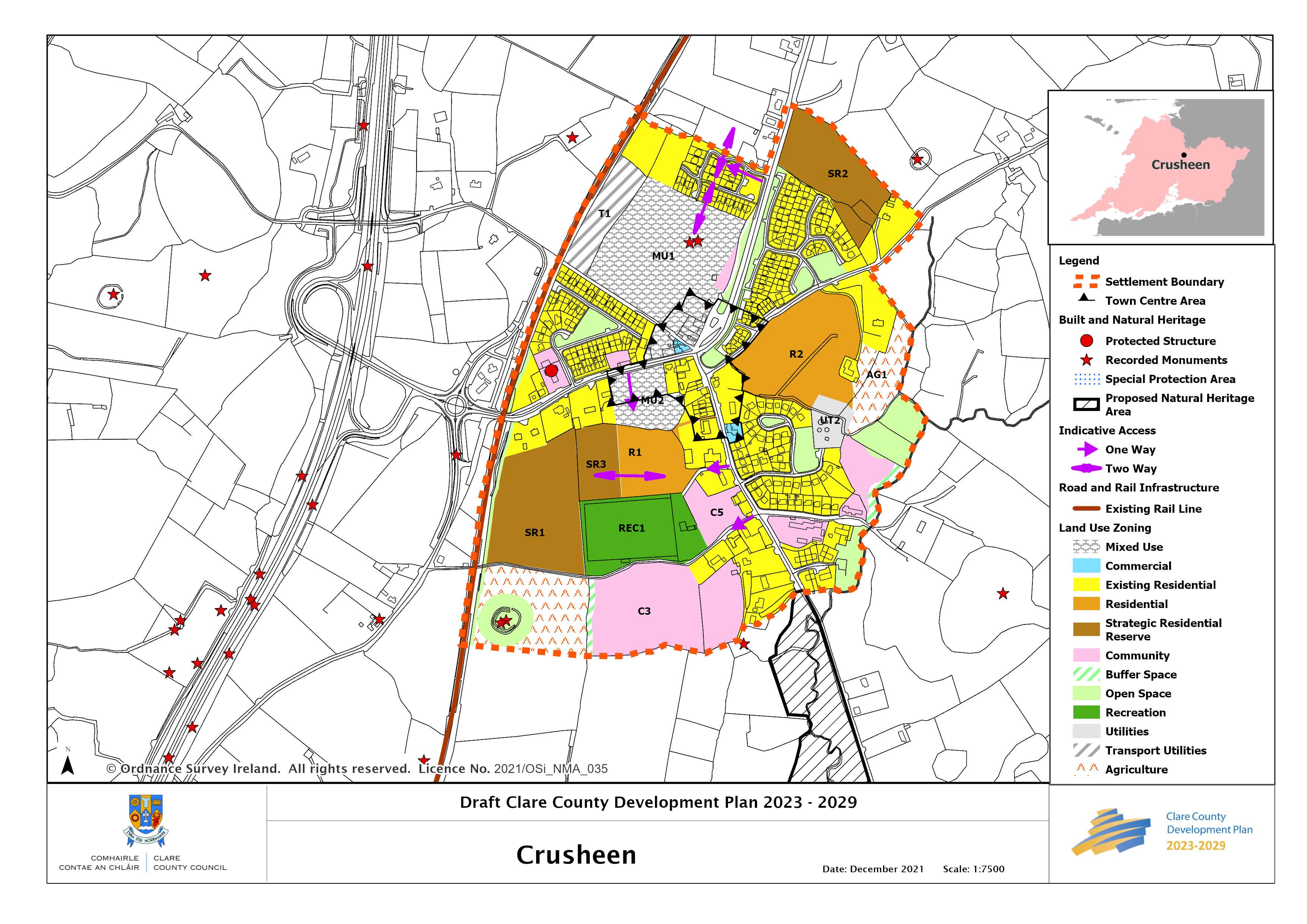
Crusheen
Location and Context
Crusheen is situated 12km north of Ennis on the R458 Ennis to Gort road. The village is also accessible directly from Junction 15 on the M18. There are many natural, historic and prehistoric features in the environs of Crusheen and the Mid Clare Way passes to the northwest of the village.
The western side of the village is located adjacent to the Ennis-Athenry railway line, which has been reinstated to provide for a passenger rail service between Galway and Limerick (the Western Rail Corridor). Crusheen, due to its location between Ennis and Galway, acts as a commuter village for both. The strategy for Crusheen will be to provide for small scale, well-designed residential, commercial and community developments which have regard to the character of the village itself. A key priority will be to retain community and social facilities within the village and to encourage indigenous enterprises and service provision.
Crusheen is connected to the Ennis Public Water Supply. The public wastewater treatment system has sufficient capacity to accommodate the population target.
Any future development should be subject to the requirements of the Habitats Directive given the proximity of the village to the Dromore Woods and Loughs SAC. Development proposals shall address the potential impact on the Qualifying Interest Feature of this site. See also the Natura Impact Report for further relevant mitigation measures and recommendations at site and project level.
General Objectives
• To promote the consolidation of the existing village through brownfield reuse/redevelopment and compact growth within zoned lands to support existing services and encourage the development of new services, whilst retaining its existing character;
• To ensure that future growth is balanced and sustainable and is relative and appropriate to the scale, size and character of the existing village;
• To support and facilitate the expansion of the village centre by encouraging infill, redevelopment of derelict, obsolete, brownfield and greenfield sites that will contribute to the creation of an identifiable village centre;
__________________________________________________________________________________ Draft Clare County Development Plan 2023-2029
• To support and facilitate the re-opening of the Crusheen train station by safeguarding lands along the route of the railway to accommodate the necessary infrastructure to facilitate a train stop in Crusheen;
• To further enhance the public realm within the village.
Employment and Enterprise
• In order to promote economic development it is an objective to cater for enterprise and economic development in Crusheen by zoning lands for mixed use.
Housing and Sustainable Communities
A number of sites are identified for housing development in the village.
R1 North of Crusheen GAA pitch
This land is suitable for residential development and shall provide for future access to the adjacent Strategic Residential Reserve to the west. Pedestrian access to Mixed Use lands(MU2), the village centre (Main Street) and the playground shall be provided for as an integrated element in the design and layout of any proposed housing development in order to ensure safe pedestrian and cycle permeability and connectivity.
Mixed Use (MU1), Transport Utilities (T1) and Community Lands on the North side of Village, West of the R458
These sites are centrally located to the village. Having removed the heavy through traffic with the M18 bypass of Crusheen, an opportunity now exists to define the village core. The zoning on the mixed use element of this site shall accommodate mixed use development, providing for retail, commercial and office uses. This site currently has the benefit of a live planning permission, and its development will consolidate and enhance the services of the settlement.
Should a new planning permission be submitted on this site of alterations sought to the live permission, the Planning Authority will seek to establish a strong streetscape element as part of any development proposal, which shall be supported by a masterplan for the overall site. In this regard, retail uses will be encouraged to front onto the main road. The provision of a public village amenity area shall be an integral element to the overall development of this site. Residential development can be accommodated on the area zoned as mixed use however the quantum of units shall be appropriate and not the predominant element to the overall scale of a mixed use scheme.
The strip of land running parallel to the railway line identified as ‘utilities’ is reserved for any future development proposals associated with the re-opening of the train station in
__________________________________________________________________________________ Draft Clare County Development Plan 2023-2029
Crusheen. Vehicular access to MU1 shall provide for the separation between traffic associated with the railway and retail access and the requirement for safe vehicular and pedestrian access to any residential development. Access to lands to the north and the lands zoned mixed use shall be provided for by an identified ‘indicative access route’ off the old N18 road (R458). Other additional vehicular access to the overall site may be permitted subject to traffic safety considerations.
R2 Ballinruan Road
This site is located between the Ballinruan Road to the north and an existing residential area and the school to the south. A large part of this site has the benefit of a live planning permission. Any future development proposals shall include investigation of drainage ditches across the site given the potential connectivity to Dromore Woods and Loughs SAC. Development proposals must provide safe cycle pedestrian linkage through the site from north to south, which shall be an integral part of the scheme and shall be overlooked by houses in any new development.
Strategic Residential Reserve (SRR)
Acknowledging that not all lands within the settlement boundary of Tulla will be required for development to 2028, lands which comprise infill or contiguous sites or have a planning history for residential use and can form part of the long-term sequential expansion of the settlement are zoned SRR. Consideration may be given to the development of some SRR lands before the end of the plan period, in line with provisions set out for Strategic Residential Reserve in Section 19.4 of Volume 1.
Transport, Active Travel and Connectivity
Bus Eireann provides an hourly service to/from Crusheen on the Galway to Limerick route. This is a valuable bus service for the village which provides an alternative to the private car. Crusheen sits on the Limerick to Galway rail line, the railway station is currently closed and the Council fully supports and encourages the re-opening of the station. This Plan includes a safeguard around the railway station to ensure adequate land is protected for it. The Council will work with the relevant stakeholders to lobby for the reopening of the rail station.
Upgrades to and provision for green infrastructure such as walking and cycling routes would promote active recreation and sustainable travel in the village and its re-opening environs and link to the Mid Clare Way which passes to the northwest of the village.
Any proposed development on zoned lands identified in the plan will be required to demonstrate how they contribute to enhanced permeability and connectivity within the village, to the village core, the national school, playground and other community facilities which would provide greater sustainable transport options.
__________________________________________________________________________________ Draft Clare County Development Plan 2023-2029
Place Making and Regeneration
The general place making objectives for Crusheen are as per those set out in Chapter 18, Volume 1 of this Plan. The principal access to Crusheen is now via a roundabout adjacent to the M18 and the R458. Along with the railway bridge this forms the principal gateway to the settlement and improvements are needed in order to form a coherent scheme, removing unnecessary clutter and, in time, providing a suitable focal point on the roundabout. Within the settlement the task is to combine traffic calming and place making along the old main road.
The village core would benefit from an improved pedestrian environment to the front of the shop/petrol station which coherently links the north of the village to the rest of the village.
__________________________________________________________________________________ Draft Clare County Development Plan 2023-2029