3 minute read
Ruan


Ruan
Location and Context
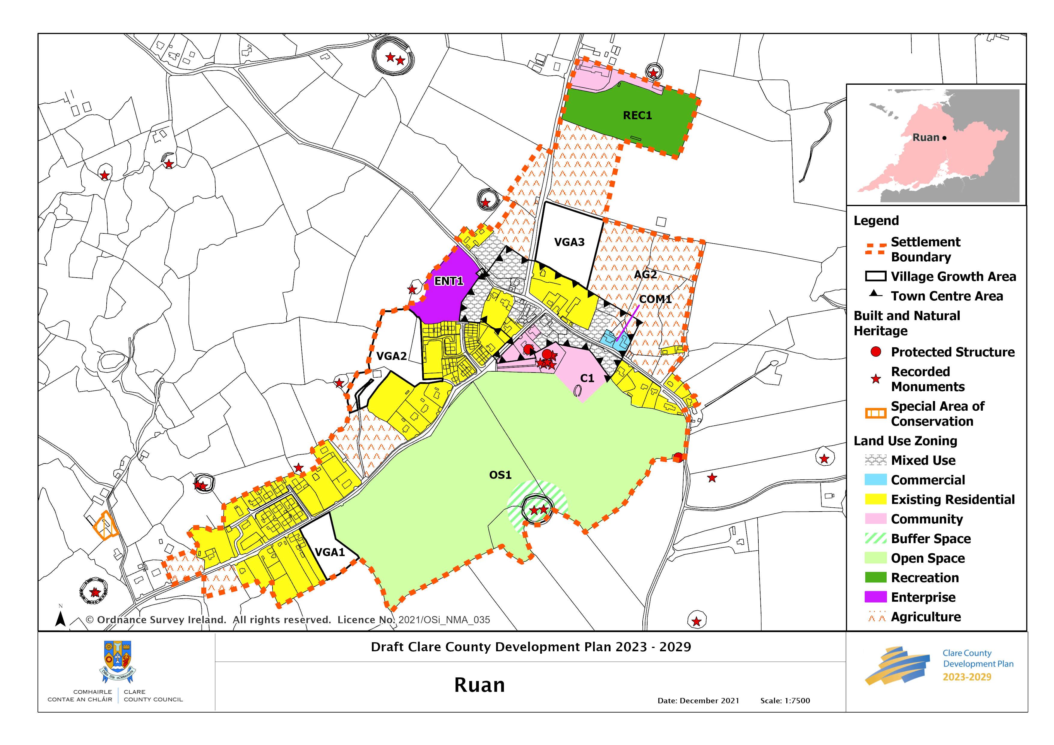
Ruan is located 11 kilometres from Ennis, midway between Ennis and Corofin, making it an accessible and attractive location to reside within commuting distance of the County Town. Situated on the Mid Clare Way walking route and a short distance from Dromore Woods, the village has a church, community centre, shop, school with adjoining GAA pitch, all of which contribute to the attractive village character of Ruan.
Ruan has a public water supply but is not served by a public waste water system limiting development to small-scale proposals. The strategy for Ruan is to encourage small-scale incremental residential growth that will be reflective of the rural nature of the settlement. Also, proposals for any suitably scaled and appropriate commercial or employmentgenerating development will be encouraged subject to the provision of a suitable wastewater treatment facility.
General Objective
• To make provision for the sustainable growth of the village which will support existing services and encourage further expansion of the service base, whilst retaining its distinctive character; • To promote the consolidation of the existing villages through brownfield reuse/redevelopment and compact growth within the designated village growth areas; and
• To ensure that future growth is incremental and small scale in nature, and is relative and appropriate to the function, scale, size and character of the villages.
Employment and Enterprise
In order to encourage economic development a site is identified for enterprise use within the settlement. Part of the village has been zoned as an area for Mixed Use which will facilitate a range of uses that can provide services for the village. It will also enable the enhancement and further development of a streetscape within the village. A new convenience store in the village has significantly enhanced the local retail offering. The proximity of the biodiversityrich Dromore Woods to the village makes it ideally suited to the provision of hospitality for those seeking recreational opportunities in the area.
Strategy for Growth and Sustainable Communities
The strategy for the sustainable growth of the village and its community is through consolidation and regeneration that promotes compact sequential growth and supports and strengthens a sustainable village community and its rural hinterland. This will be achieved by
__________________________________________________________________________________ Draft Clare County Development Plan 2023-2029
encouraging small scale growth in areas which make a positive contribution to the overall enhancement of the village and sustains it into the future. In line with this approach and to promote vibrant rural villages, village growth areas have been identified which provide opportunities and choice for development, including small scale commercial, enterprise, community, services/facilities as well as small scale cluster housing, all of which offer a viable and attractive option for rural living within a village community and setting
The delivery of any new development in Ruan will be encouraged by adopting a combined approach of sequential compact growth and the re-use and redevelopment of vacant or derelict sites and buildings within the village.
Any proposals should ensure/enhance connectivity within the village and support the sustainable use of existing services and facilities. Any development is highly dependent on the suitability of the land to accommodate on-site wastewater treatment systems.
Place Making and Regeneration
This is a charming, largely unspoilt settlement. The approaches on all sides are well defined by stone walls, grass verges and in some cases mature trees. On entering, many of the front boundaries and forecourt areas complement the public spaces while gravelled set-backs in front of some developments have the opposite effect. The integrity of front boundaries should be protected as part of any new development.
The core area is well maintained but there is an opportunity to further enhance the village core. Any future development on the Mixed Use zoning north of C1 must provide a strong streetscape and be of a high design and quality with particular attention paid to the treatment of the corner at the junction of the two roads. In order to accommodate the needs of the village, an area of land has been identified for community development to the southeast of the old church (in ruins) and adjoining cemetery.
OS1
The hedgerow along OS1 should be maintained as a foraging and commuting area for bats in this area. A buffer zone to protect the two recorded monuments CL025-069001 and CL025069002 (Ringfort) and one protected structure (Kelly Mausoleum, RPS 230) should be maintained around these structures as part of any future development.
__________________________________________________________________________________ Draft Clare County Development Plan 2023-2029