
2022 CLAUDIA CRESPO PORTFOLIO

CLAUDIA CRESPO Puerto claudiacrespo2015@gmail.comRicoArchitecturalDesigner


Summer2019-20202018-20202020-20222020-202220222021202120182015-20192018-201920182015-2019 2016-20182015-2022202220182018Spring2015-201920192012-2015 Master of Architecture University of Puerto Rico Summa Cum Laude - 4.00 GPA Bach. in Environmental Design University of Puerto Rico Magna Cum Laude - 3.93 GPA Study Abroad Program Universidad Complutense de Madrid Art History and Criticism High ColegioSchoolMarista de Guaynabo EDUCATION ResearchRISE-UPand Teaching Assistant Interdisciplinary undergraduate program focused on sustainability. ResearchCüirtopiaand Design Assistant A queer mapping project of caribbean buildings and territories, by Dr. Regner LayerRamos. Design Collective Project Designer Toro GraphicDeArchitecturalDíazArchitecturalArquitectosColemArchitecturalArquitectosInternanDavis-PagánInternPaunettoArquitectosInternPuebloDesigner EXPERIENCE Outstanding Thesis Awarded to “Villas Pesqueras of PR” Dean’s Honor Roll University of Puerto Rico High Honors Scholarship University of Puerto Rico AWARDS Villas del Sol Toa Baja, PR Design and development of a recreational area for the community after the impact of hurricane María. Proyecto Enlace Caño Martín Peña, PR Development of as-built drawings used to provide new roofs to the families affected by hurricane María. VOLUNTEER Spanish + English Fully bilingual speech / writing / reading LANGUAGES AIAS UPR Public Relations [2018] Class Representative [2019] Marroneo Coop. Treasurer MemberNSCSPublicStudentrunArchitectural[2018-2019]supplystorebystudents.CouncilRelationsCommitteeUPRUPRRPChapter EXTRACURRICULAR Travel Culture Music Film Sports INTERESTS 01. Hand03.LeadershipTeamworkResponsibleOrganizedCreative02.QGISRevitGrasshopperSketchUpRhinocerosAutoCADSoftwarePersonalOtherDrawing/ Painting / Model Making / Research / Storytelling / Filmmaking / Photography / Graphic Design SKILLS Adobe Photoshop Adobe Illustrator Adobe Indesign Adobe Premiere Pro V-RayLumion
PROJECTS The following material is a selection of academic works. For more info visit: Web Portfolio

MERCADO OTHERSCASACIUDADCENTRO_ARRECIFESALADOCOSTERAMANGLE “Villa Pesquera” + Hospitality Research Center Master Plan + Urban Design Social Housing Film / Graphic Design / Model 06 15 16 23 24 31 32 39 40 41
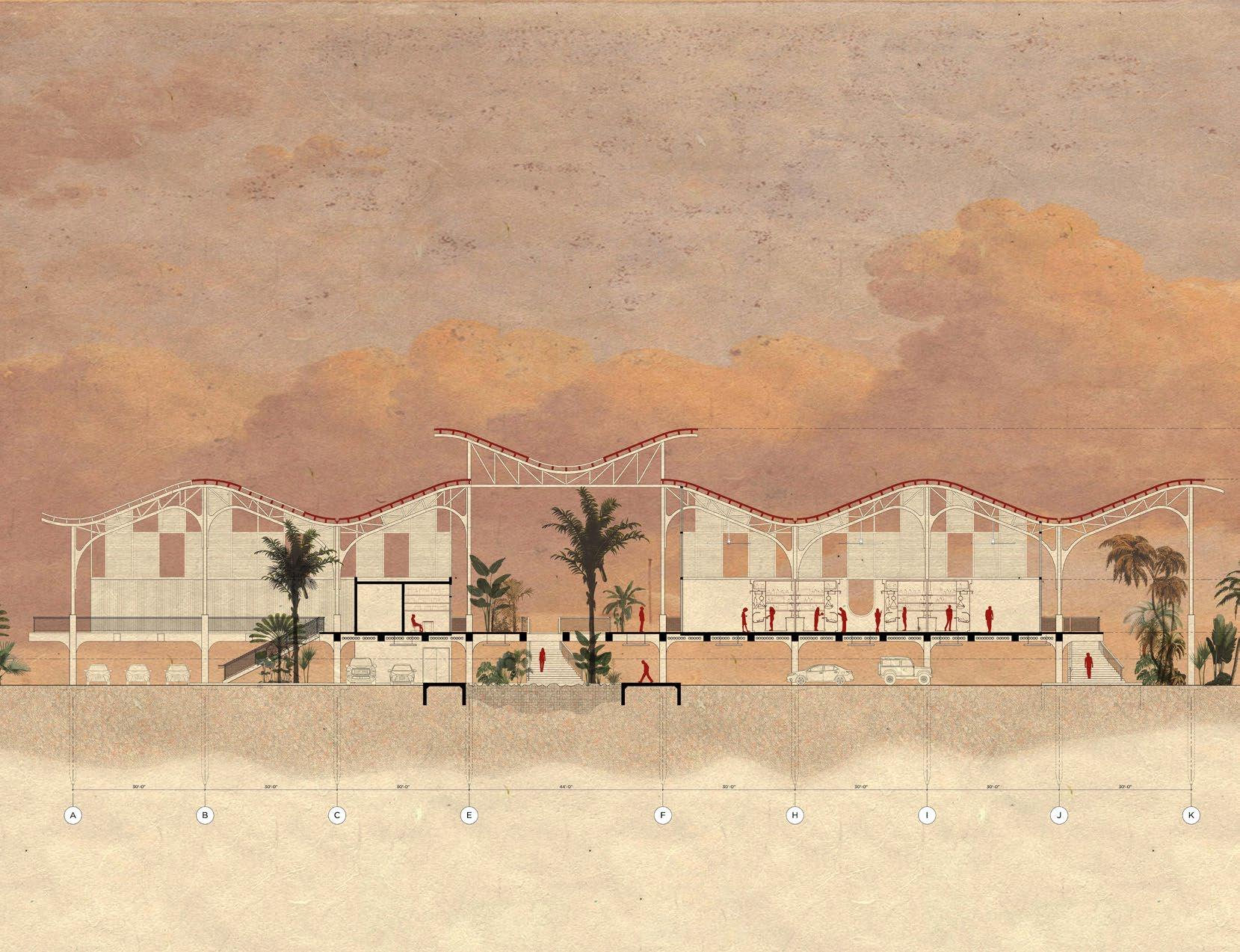
Mercado Salado is the architectural project of the thesis “Villas Pesqueras of Puerto Rico: Documenting the Coastal Culture Through Architectural Discourse”, which documents traditional fishing villages around the island and emphasizes how these communities have been historically marginalized using filmmaking as an architectural research method. The project inserts traditional Puerto Rican fishing villages in direct confrontation with public policies that exclude locals from access to the coasts, while granting access to the tourism industry. In this way, it challenges issues of community displacement, legislation, and the right locals have to their land. The imminent rise of sea level is used as the framework to destabilize existing zoning regulations to safeguard the existence of a local fishing community while recognizing that part of Mercado Salado and its site will be lost to the waters.
6mercadosalado
MERCADO SALADO Master’s Thesis (2021-2022) Punta Santiago, Humacao Dr. Regner Ramos, Arch. Fabiola Guzmán + Arch. KleanthisMercadoKyriakouSalado es el proyecto de arquitectura de la tesis “Villas Pesqueras de Puerto Rico: Documentando la cultura costera a través del discurso arquitectónico”, que documenta pueblos pesqueros alrededor de la isla y enfatiza cómo estas comunidades han sido históricamente marginadas utilizando el filme como método de investigación
“You merged climate change, disappearing communities, and new economies so beautifully. What you’ve done really well is that you’ve accepted that hospitality, if treated in certain ways, can add to the livelhihood of those communities. We have this multipurpose, part-submerged, infrastructure of seas, that redefines what ‘Villas Pesqueras’ are, extending their program in a way that I’m not sure it exists in the context of the Caribbean.” (Arch. Kleanthis Kyriakou)
‘Villa Pesquera’ + Hospitality
Elarquitectónico.proyectoinserta a las tradicionales Villas Pesqueras puertorriqueñas en confrontación con las políticas públicas que excluyen a los locales hacia el acceso a las costas, mientras otorga acceso a la industria del turismo. De esta manera, cuestiona temas de desplazamiento comunitario, legislación y el derecho que tienen los locales a su tierra. El aumento inminente del nivel del mar se usa como marco para desestabilizar las regulaciones de zonificación existentes para salvaguardar la existencia de una comunidad pesquera e incluso, reconoce que parte de Mercado Salado y su terreno se perderá en las aguas.


saladomercado8 “El Pescador” Level 2 Level 2 Level 2Level 1 Level 1 Level 1 “Planúa” “Playeros” Level 1 Site Plan


sea level 2100 sea level 2022 saladomercado9


10mercadosalado section a the pier


ramp access + exposed structure saladomercado11


The architectural piece incorporates and restores the historic pier used for the sugar cane industry during the 1920s-1970s, giving it a new meaning and acknowledging the effects of rising sea levels up to 2100. The project has three main components: the pier that receives the visitors from the ferry and where the hotel rooms are inserted, the ‘Varadero’ where fishers work, give maintenance to their boats and craft their fishing techniques, and lastly, the market that has direct access to the community and is composed of a fish market, fishing gear shop, administration offices, restaurant, and hotel check-in where guests are greeted with a complementary drink –mojito of
saladomercado12
Thesargassum–.structure of the building is composed of a steel truss system that forms an undulating effect representing the ocean’s waves. Its ceiling is subdivided into bands that shift in one plane to indicate that coasts are not static and they are constantly transforming. The commemorative buoy, the landmark that crowns the end of the pier, serves as a viewing platform, a measuring device for weather conditions for the fishers, and a symbol with the Puerto Rican flag attached, honoring the community’s response after hurricane María.
As a result, Mercado Salado reimagines what could be the future of the ‘Villa Pesquera’, implementing the economy of the sea.


check-inhotel restaurantbar saladomercado13


saladomercado14


wall sectionsectionb saladomercado15

Centro Arrecife becomes the link between nature and architecture, acting as a research center for the conservation and preservation of the reef. Its strategic location is in Punta Vacía Talega due to the occupation of different natural components –the mangrove, the forest, the rock formation, the beach, and the reef– key to maintaining a healthy reef. The architectural interventions of the complex fill the remnants that nature has left and are entirely raised from the ground to prevent a more significant ecological impact on the site. The proposal becomes a path through the landscape that achieves well-being between architecture and nature. Centro Arrecife is an intervention that celebrates the natural resources of Loíza and promotes the importance of their
centro_arrecife16
preservation.Research Center
CENTRO_ARRECIFE
Master’s Studio (2021) Punta Vacía Talega, Loíza Prof. Fabiola Guzmán Prof. AlejandroCentroMiesesArrecife alcanza ser el vínculo entre la naturaleza y la arquitectura, actuando como un centro de investigación para la conservación y preservación del arrecife. Su ubicación estratégica se sitúa en Punta Vacía Talega por la ocupación de diferentes componentes naturales –el mangle, el bosque, la formación rocosa, la playa y el arrecife– claves para mantener un arrecife saludable. Las intervenciones arquitectónicas del complejo están emplazadas en los remanentes que ha dejado la propia naturaleza y quedan completamente levantadas para no causar un mayor impacto ecológico en el lugar. La propuesta se torna en una especie de recorrido a través del paisaje que logra el bienestar entre la arquitectura y la naturaleza. Centro Arrecife es una intervención que funciona como una muestra para celebrar los recursos naturales de Loíza y fomenta la importancia de su preservación.


centro_arrecife18 How to intervene in a protected space? What space can be achieved for the preservation of natural resources?


centro_arrecife19

centro_arrecife20


centro_arrecife21


centro_arrecife22


centro_arrecife23


La isleta de San Juan enfrenta un gran reto: estar a la altura de su nombramiento de ciudad. Estando altamente segmentada, el diseño urbano desarrollado busca unificar las diversas zonas olvidadas, fomentar la actividad peatonal recreativa, resaltar la cualidad de ciudad costera y crear ciudad en un lugar suburbano. El malecón, la cinta que amarra y conecta los puntos importantes de la ciudad, se complementa con plazas, miradores, paseos y parques destinados para el disfrute y uso del peatón, y una rambla que funciona como el eje conector central peatonal, vehicular y visual. En este ejercicio trabajamos con un predio de terreno importante en el extremo este del islote de San Juan. Estos terrenos están definidos al norte y al oeste por el Océano Atlántico, al sur por el Parque Luis Muñoz Rivera y al este por la playa del Escambrón y los hoteles Caribe Hilton y Normandie.
costeraciudad24
The islet of San Juan faces a significant challenge: living up to its designation as a city. Being highly segmented, the urban design developed seeks to unify the neglected areas, encourage recreational pedestrian activity, highlight the quality of a coastal city, and create a town in a suburban place. The boardwalk, the strip that ties and connects the critical points of the city, is complemented by squares, viewpoints, promenades, parks intended for the enjoyment and use of pedestrians, and a boulevard that functions as the central pedestrian, vehicular, and visual connecting axis. In this exercise, we work with a large piece of land on the eastern end of the islet of San Juan. These lands are defined north and west by the Atlantic Ocean, south by the Luis Muñoz Rivera Park, and east by the Escambrón beach and the Caribe Hilton and Normandie hotels. Master Plan + Urban Design
CIUDAD COSTERA Master’s Studio (2020) Puerta de Tierra, San Juan Prof. José Javier Toro Annelis Aldeból, Verónica Vázquez + José Betancourt


26ciudadcostera 2 8 1 67543 21 “La Ocho” Plaza Luis Muñoz Rivera Park 43 “La EscambrónRambla”Park 65 Sports Plaza Caribe Hilton Plaza 87 Tribunal Plaza South Promenade 200’ 400’ 1200’ SiteurbanPlancomponents nodes program + activity building relation


Caribe Hilton Plaza Escambrón Park Tribunal Plaza “La Ocho” Plaza “La SportsRambla”Plaza 4321 islet roundabout entrance mixed use office building caribe hilton plaza supreme court 4321 suprememonumentcourt access luis muñoz rivera park boulevard 321 promenade steps soccer field escambrón fort 321 caribe hilton hotel sunken plaza water sports access 321 normandie hotel sunken plaza public bathroom 321 isabel II plaza luis muñoz rivera park viewpoint 8765 parking opening sports parkingplazaplatform a parking platform b 8765 colonial powderhouse north parkingparkingpromenadeplatformaplatformb 654 promenade view point commercial zone “la ocho” beach 654 san gerónimo fort caribe hilton gardens main plaza level 654 tennis court beach promenadeaccess 654 park peaceskateparkextensionpavilion111 111444 453222 222555 5654333 343666 6 7 7 8 68 costeraciudad27


costeraciudad28 escambrónsectionparkpromenadeviewpoint


stepspromenade costeraciudad29


30ciudadcostera


“lasectionsportssectionplazaocho”plaza costeraciudad31


CASA MANGLE Third Year Studio (2018) Piñones, Loíza Prof. María H.TrasLuengoel paso del huracán María la comunidad de Piñones quedó afectada por los grandes vientos e inundaciones. La comunidad se distingue por su gran población de mangles, que por sus propiedades estructurales naturales resistieron el impacto del huracán. Traducido al diseño, el concepto de la vivienda social proviene del mangle. Las viviendas se suspenden en una red de vigas y columnas expuestas que están amarradas como las raíces del mangle y esta solución atiende el problema de inundación. El diseño de estas es resuelto con un sistema modular con elementos prefabricados que tienen la posibilidad de incrementar según la necesidad de las familias. En una de las opciones modulares el primer nivel queda completamente libre y el espacio funciona como área social para reunir a la comunidad al igual que ocurre con la biodiversidad marina en la parte inferior del mangle.
manglecasa32
After hurricane María, the community of Piñones was affected by the intense winds and floods. The community is distinguished by its large population of mangroves, which, due to their natural structural properties, resisted the impact of the hurricane. Translated into the design, the concept of the social housing complex is derived from the mangrove. The houses are suspended on a network of exposed beams and columns that are tied together like mangrove roots, and this solution addresses flooding issues. The design is solved with a modular system with prefabricated elements that have the possibility of incrementing according to the needs of the families. In one of the modular options, the first level is entirely free. This space is a social area to bring the community together, just as it happens with marine biodiversity in the mangrove’s roots. Social Housing


manglecasa34 Site Plan 15’ 30’ 50’ 100’

manglecasa35

manglecasa36 level 1 level 2 level 1 level 2 - increased level 1 - increased level 3 level 2 level 3 - increased level 2 - increasedmoduleamoduleb

manglecasa37 isometric module a

manglecasa38 elevationsectionkitchen


manglecasa39 module a social space


(2021)
Un cortometraje documental que da voz a una comunidad históricamente marginada. El filme narra las historias y luchas de los pescadores de tres Villas Pesqueras tradicionales alrededor de la isla de Puerto Rico, en las cuales resaltan la importancia de estos espacios, su cultura, preocupaciones con la legislación y el cambio climático.
“Villas Pesqueras” (2021) A short documentary film that gives voice to a historically marginalized community. The film narrates the stories and struggles of the fishers from three traditional fishing villages around the island of Puerto Rico, in which they highlight the importance of these spaces, their culture, and concerns with the legislation and climate change.
Complementary works developed for academic projects“VillasPesqueras”
“Aunque el mar no se ve, se intuye” (2020) Análisis cartográfico de ciudad costera: La Habana, Cuba. El famoso malecón de la ciudad une la ciudad y el mar, destacando su importancia en la historia, economía y cultura. El estudio de La Habana muestra que, aunque “el mar no se ve, se intuye”. Maqueta de bajo relieve (2017) Maqueta de estudio sobre el “Vagelos Education Center” de Diller Scofidio + Renfro. En este ejercicio, se solaparon y manipularon diferentes plantas, secciones y alzados del edificio en la maqueta para resaltar las cualidades espaciales y las conexiones de la torre.
“Aunque el mar no se ve, se intuye” (2020) Mapping analysis of coastal city: Havana, Cuba. The city’s famous promenade ties the city and the sea, highlighting its importance in its history, economy, and culture. The study of Havana shows that although “the sea is not seen, it is always Lowsensed”.Relief Model (2017) Study model on Diller Scofidio + Renfro’s Vagelos Education Center. In this exercise, different floor plans, sections, and elevations of the building were overlayed and manipulated in the model to highlight the peculiar spatial qualities and connections of the tower.
40others


THANK GRACIASYOU