6 minute read
UNVEILING THE REPUBLIC OF SERBIA’S
Unveiling The Republic Of Serbia's NEW SPATIAL PLAN
The Spatial Plan of the Republic of Serbia represents the basic planning document for spatial planning and development in the country, with which the long-term strategic framework for the directing and managing of spatial development is determined. The third Spatial Plan of the Republic of Serbia is harmonised with the new 'Serbia 2025' national investment programme and other strategic documents.
The preparation of the Third Spatial Plan of the Republic of Serbia is the result of multiple decades of continuous spatial planning in the Republic of Serbia and represents the continuation of the previous two planning cycles. The First Spatial Plan of the Republic of Serbia was adopted in 1996, following an unusually long process (almost three decades). The First Spatial Plan was adopted under specific socio-economic circumstances and lacked elaborated instrumentation for its implementation. The Second Spatial Plan of the Republic of Serbia, which is currently in force, was adopted in 2010 with an envisaged time-frame lasting until 2020. The implementation of this plan is supported by implementation programmes and reports on the realisation of the spatial plan for the first time in the practice of planning.
The Third Spatial Plan of the Republic of Serbia is currently being prepared under the circumstances of the global pandemic of the COVID-19 infectious disease, in accordance with the new “Serbia 2025” national investment programme, sectoral strategies, development planning documents and public policies, the results of previous research, the conditions of competent public institutions and bodies, as well as being aligned with international frameworks and documents pertaining to the field of spatial planning and spatial development. The scope of the Spatial Plan encompasses the territory of the Republic of Serbia, in accordance with the Constitution of the Republic of Serbia and the Law on Territorial Organisation of the Republic of Serbia. The implementation time-frame is harmonised with the long-term time-frame of the majority of sectoral strategies. The long-term strategy, concepts and planning solutions for spatial development are defined for a time-frame extending until 2035. Some solutions in this plan are perceived for a lasting period that is not limited to the specific time-frame. The implementation of national goals and the strategic commitments of spatial development will be enabled through the applying and elaborating of long-term strategic, conceptual and planning solutions of the spatial plan in the development of planning documents, public policies, spatial and urban plans. The harmonising of national, regional and local interests and development priorities will be implemented through the development of planning documents at the regional and local level, within the scope of which planning solutions and priorities will be further developed in
accordance with the spatial plan’s guidelines.
The bearer responsible for preparing this spatial plan is the Ministry of Construction, Transport and Infrastructure. Its expert processors include:
The Institute of Architecture and Urban &
Spatial Planning of Serbia (works contractor on behalf of the group of processors),
The Faculty of Geography, University of Belgrade;
The Faculty of Architecture, University of Belgrade;
The Traffic Institute CIP Ltd., Belgrade;
The Urban Institute of Vojvodina public enterprise, Novi Sad
GDI SOLUTIONS LTD., Belgrade.
The Spatial Plan is being prepared in accordance with the Decision on the Development of the Spatial Plan of the Republic of Serbia from 2021 to 2035, which was adopted by the Government of the Republic of Serbia in 2019. In accordance with the Law on Strategic Environmental Impact Assessments, a report on the strategic environmental impact assessment of the spatial plan is being prepared in parallel with the development of the spatial plan.
The legal basis for the preparation of the spatial plan is provided by the Law on Planning and Construction and the Ordinance on the contents, manner and procedure of drafting spatial and urban planning documents. The preparation of this spatial plan is also based on other relevant laws, by-laws and regulations. The Law on the Planning System of the Republic of Serbia recognises the Spatial Plan of the Republic of Serbia as a development planning document. This spatial plan does not regulate matters that are subject to special laws (territorial organisation, construction land, water, forests, mineral resources, environmental protection, the protection of natural and cultural heritage, land defences, infrastructure ranking etc.), but rather forms a strategic framework of spatial development through planned synthesis.
The compiling of this spatial plan began in the fourth quarter of 2019 and encompassed the preparing and producing of materials for advanced public inspection, thematic studies and drafts of the spatial plan.
Advanced public inspection was conducted in the period from 2nd to 16th March 2020, with a report compiled on the conducted advanced public inspection in accordance with the law. Three thematic studies were conducted (1. “Economy, transport and infrastructure”, 2. “Nature, environment and cultural assets” and 3. “Population, settlements and social development”, which contain ten basic areas with a total of 36 special study contributions, covering in excess of 1,500 pages), as well as the Planning Atlas (which contains approximately 40 thematic and synthesised maps made using GIS technology, in which geospatial and statistical data are processed, as well as key indicators from thematic studies), which represent the basis of study for the drafting of the spatial plan.
In accordance with the law and regulations adopted on the basis of the law, the draft spatial plan will contain:
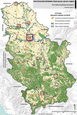
1) Starting points (introduction; preparation method; review of the planning system and planning basis; impacts of globalisation and the surrounding lands on the spatial development of the Republic of Serbia; the territory of the Republic of Serbia in the broader European environment; general assessment of the situation according to thematic areas, with a synthesised assessment of potentials, limitations and key spatial development problems); 2) Objectives and planning solutions (scenarios of spatial development; principles of spatial development; visions, general and specific objectives of spatial development; long-term spatial development strategy; planning solutions according to thematic areas – protecting and utilising natural resources, heritage and the environment, population and social development, regional development, the economy, infrastructure, and the protection and use of space); 3) Implementation (priority planning solutions; implementation measures and instruments; relations regarding public policies and guidelines for implementation in the planning system; the compilation and adoption of planning documents; spatial development indicators; guidelines for the preparation of PPRS implementation programmes); 4) Referral maps at a scale of 1 : 300,000 (1. “Purpose of space”; 2. “Network and system of urban centres and rural areas”; 3a. “Transport and electronic infrastructure”; 3b. “Water management and energy infrastructure”; 4a. “Tourism and Spatial Protection” and 4b. “Environment”).
The geodata of the spatial plan are contained in a spatial database created using GIS technology. This database contains geodata submitted by holders of public authorisations, companies and institutions in the legally established procedure for obtaining conditions, data and groundwork. The database contains information on the institution that provided the data – the owner of the data and the reference scale. This database can be used for the preparation of other planning documents.
Selected geodata from the GIS database are presented on reference and thematic maps of the spatial plan in an adapted cartographic scale. For the preparation of other planning documents, as a rule, they are not applied directly, but rather are determined in more spatial detail in accordance with the appropriate scale and the legally prescribed procedure.

A public inspection of the draft spatial plan will be held in April 2021. Following the conclusion of this public inspection, it remains for the proposed Law on the Spatial Plan of the Republic of Serbia to be determined by the Government, and its consideration and adoption in the National Assembly of the Republic of Serbia


