for Cambridge IGCSETM and O Level MULTI-COMPONENT SAMPLE


We are working towards endorsement of this title for the Cambridge Pathway.

We are working towards endorsement of this title for the Cambridge Pathway.
We are working
Dear Teacher,
Welcome to the third edition of our Cambridge IGCSETM and O Level Geography series. We have developed this series to support the updated Cambridge IGCSETM, IGCSE (9-1) and O Level Geography syllabuses (0460/0976/2217) for examination from 2027.
This series has been designed to flexibly meet your teaching needs, including extra support to help prepare for assessment. This preview will help you understand how the coursebook and the teacher’s resource work together to best meet the needs of your classroom, timetable and students.
This Executive Preview contains sample content from the series, including:
• a guide explaining how to use the series
• a guide explaining how to use each resource
• the table of contents for each resource
In developing this new edition, we carried out extensive global research with Cambridge IGCSE and O Level Geography teachers – through interviews and work on the Cambridge Panel, our online teacher research community. Teachers just like you have helped our experienced authors shape these new resources, ensuring that they meet the real teaching needs of the geography classroom.
The coursebook has been specifically written to support English as a second language learners with key subject words, glossary definitions in context and accessible language throughout. We have also provided new features that help with geographical skills, active learning, assessment for learning and student reflection. Numerous tasks and practice questions with answers in the digital coursebook, which accompanies the print coursebook, help your students feel confident approaching the assessment.
Core to the series is the brand-new digital teacher’s resource. It will help you support your learners and give you the tools to teach the updated syllabuses with confidence, whether you are new to teaching the subject or more experienced. For each topic there are lesson ideas and activities, common misconceptions to look out for, skills and language worksheets, answers to the coursebook, end-of-unit tests and more. Also included is a practical guide to enquiry-led teaching to help you engage your students in the subject.
Please take some time to find out how our resources will support you and your learners. To view the full series, you can visit our website or speak to your local sales consultant. You can find their contact details here:
cambridge.org/education/find-your-sales-consultant
Best wishes,
Dr Biljana Savikj
Commissioning Editor
Cambridge University Press & Assessment
We are working towards endorsement of this title for the Cambridge Pathway.
This suite of resources supports learners and teachers following the Cambridge IGCSETM, IGCSE (9-1) and O Level Geography syllabuses (0460/0976/2217) for examination from 2027. The components in the series are designed to work together and help learners develop the necessary knowledge and skills for studying Geography.
Geography


The Coursebook is designed for learners to use in class with guidance from the teacher. It offers full coverage of the Cambridge IGCSE, IGCSE (9-1) and O Level Geography syllabuses. Each topic contains explanations, definitions, a variety of tasks and detailed specific examples with questions to engage learners and develop their geographical skills.
The Teacher’s Resource is the foundation of this series. It offers inspiring ideas about how to teach this course including teaching notes, how to avoid common misconceptions, suggestions for differentiation, formative assessment and language support, answers and extra materials such as worksheets and end-of-topic tests.


Geography


The Exam Preparation and Practice* provides dedicated support for students in preparing for their final assessments. The resource includes hundreds of knowledge recall questions, a checklist of exam skills with corresponding questions, past paper question practice, and reflection features. This resource should be used alongside the coursebook, so students can effectively increase their confidence and readiness for their exams.
*This text has not been through the endorsement process for the Cambridge Pathway. Any references or materials related to answers, grades, papers or examinations are based on the opinion of the author(s). The Cambridge International Education syllabus assessment guidance material and specimen papers should always be referred to for definitive guidance.
Tana
Scott, Paul Thompson, Helen Young, James Hickman & Stuart Colesky

Third edition with Digital access

investigate the units of measurement used in microscopy, calculate the real size of objects from a given magnification.


Learning intentions open each topic. These help you to navigate through the coursebook and highlight the most important learning points in each topic.
Key vocabulary is highlighted in the text when it is first introduced. An accompanying definition tells you the meanings of these words and phrases. You will also find definitions of these words in the Glossary at the back of the book.
Some tasks are accompanied by source material such as maps, images, and charts which you will use to answer questions, complete tasks and develop your geographical skills.
Detailed specific examples are case studies that allow you to actively explore the concepts in each topic and apply them to a recent, real-life context. Each example has accompanying sources and tasks for you to further practice and develop your skills. In the digital version of the coursebook, you will also have access to a video for the detailed specific example in each topic, alongside additional questions available in the Teacher’s Resource.
At the beginning of each topic there is a getting started activity. These are pair, group or class activities that introduce you to the topic and provide you with the opportunity to show how much you already know about the topic you will be learning.
You will find a variety of tasks throughout the coursebook. These give you opportunities to think about what you have learned, discuss topics, answer questions or produce your own work either individually, in pairs or in groups.
These are helpful reminders or notes that give advice on skills or methodology. You will find them most often near activities, where they will be directly relevant to the task.
These activities enable you to look back on your work and encourage you to think about your learning. You will reflect on and assess the process that you used to arrive at your answers.
This is an opportunity for you to use the skills you are developing within the topic and apply them to your lives today. You will begin to make connections between employment and studying geography.
Skills
Learning and developing geographical skills is an important part of this course. As well as a dedicated skills section, individual tasks highlight using bold text when a skill is being used.
The Digital Coursebook contains videos to accompany the detailed specific examples. The videos encourage students to talk about the themes of the topic, introduce topic vocabulary and describe and explain concepts, processes and job roles related to the detailed specific example. Additional questions to accompany the videos are included in the Teacher’s Resource.

Each topic includes an example of an answer to an extended writing question, with detailed analysis of how the answer is successful and areas for improvement. You can use these examples to write your own answer to the question, and to help you think about how to answer practice questions later on.
Each topic contains a project that uses the skills you develop throughout the coursebook. The project encourages you to apply these skills to a real-world task in pairs or groups.
The summary checklists provide you with a series of statements at the end of each topic outlining the content you should now understand. When you are revising, you might find it helpful to rate how confident you are for each of these statements. You should also provide an example to support your chosen statement.
At the end of each theme, you will find a set of practice questions for each topic that use the command words from the syllabus. To answer these, you will need to apply what you have learned throughout the topics you have just studied.
We
We


By the end of this topic you will be able to:
• understand the key characteristics of rivers and the underlying processes at work in drainage basins
• understand the processes involved in erosion, transportation, and deposition in the context of river systems
• describe and explain the formation of various river landforms found in the upper, middle, and lower sections of rivers
• explore the advantages and risks associated with living near river environments
• investigate and explain how regions with issues such as flooding and pollution have implemented sustainable strategies to address these challenges.
Work in small groups or with a partner. Each group should take a few minutes to discuss their personal experiences or knowledge related to rivers and their importance in our environment. This could involve sharing stories, facts, or any relevant information you are familiar with.
Record your ideas on a sheet of paper. After the discussion, each group must select a spokesperson to share one interesting fact or insight with the class. Be prepared to explain why your group thinks this information is important or interesting.
The water cycle, or hydrological cycle, refers to the movement of water between the atmosphere, land and sea. It is a cycle because there is no start or end.
Water falling as precipitation either:
• flows over the land as channel flow
• flows through the land as groundwater
• travels back into the atmosphere through evapotranspiration
• is stored on or within the land, for example, in vegetation, soils, lakes, or glaciers.
Condensation
Evapotranspiration Transpiration
Precipitation
Evaporation
Precipitation: water falling from the air onto the land, for example, rain, snow, and hail.
a Make a copy of the diagram below. Label arrows a, b, c, e, and f to show how water moves between the atmosphere, ocean, and land.
b Look at the diagram below. Explain why water does not move directly from the ocean to the land (arrow d).
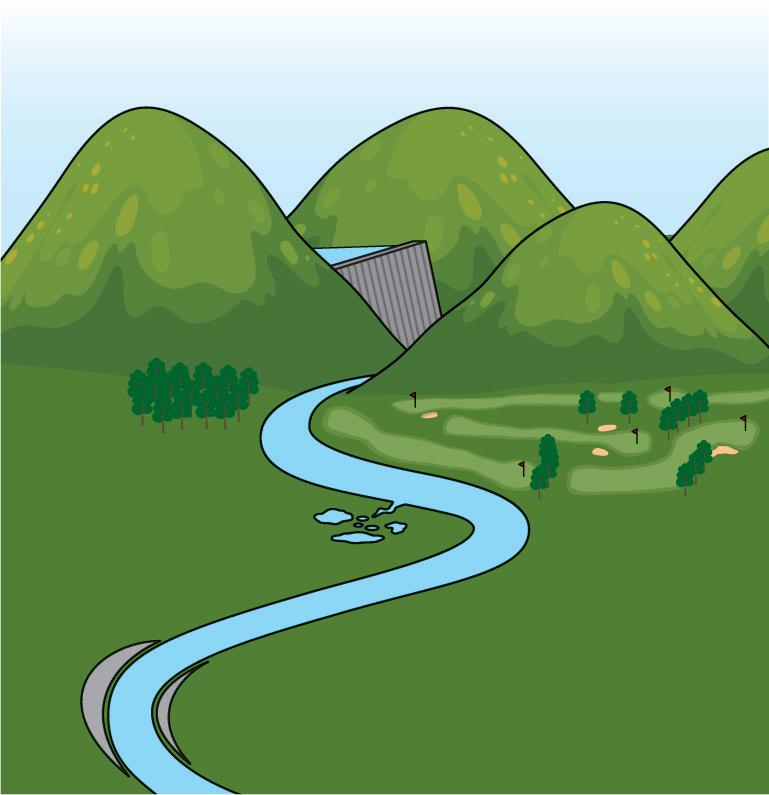
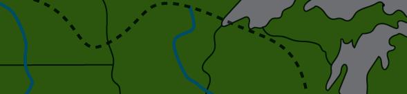
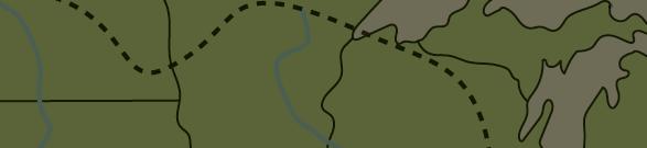
Rivers are an important part of the water cycle. They are channels of water that flow over the Earth’s surface. The start of a river is called the source and the end is called the mouth. Through gravity, rivers transport precipitation that falls onto the land down towards the sea.
The characteristics of rivers change between the source and the mouth. The Bradshaw model is a theoretical model that shows these changes. In the model, triangles are used to represent changes along the course of a river. Upstream Downstream
Source: the start of a river, usually in highland areas.
Bedload particle size
Average velocity Discharge
Mouth: the end of a river, sometimes found where the river enters the sea.
Channel depth
Bedload quantity
Channel bed roughness
Gradient
Source B : The Bradshaw model
Wetted perimeter: the part of the river channel that is in direct contact with the water in the river, for example, the riverbed and banks.
Discharge: the volume of river water flowing past a given point at a given time.
In upland areas, closer to the source, rivers tend to be narrow and shallow. They have a smaller wetted perimeter and a lower discharge, because they carry less water than lowland rivers. Upland rivers have a lower velocity, which means they are slower flowing. This is because the large bedload (material located on the riverbed) creates friction, which slows the water down.
In lowland areas, closer to the mouth, rivers are wide and deep. They have a much larger wetted perimeter and a higher discharge because they have flowed over a longer distance, collecting more water as they go. Lowland rivers have a higher velocity (speed of flow), as there is less friction from the riverbed and banks.
Create a table like the one below. Complete all boxes in the table by choosing the correct word from each cell.
River source River mouth
Width wide/narrow wide/narrow
Depth deep/shallow deep/shallow
Velocity faster/slower faster/slower
Discharge higher/lower higher/lower
Gradient steep/gentle steep/gentle
It is easy to get confused about changes in river velocity between the source and the mouth. Think of it like a ball rolling down a hill; the ball will speed up as it rolls and will be travelling much faster at the bottom of the hill.
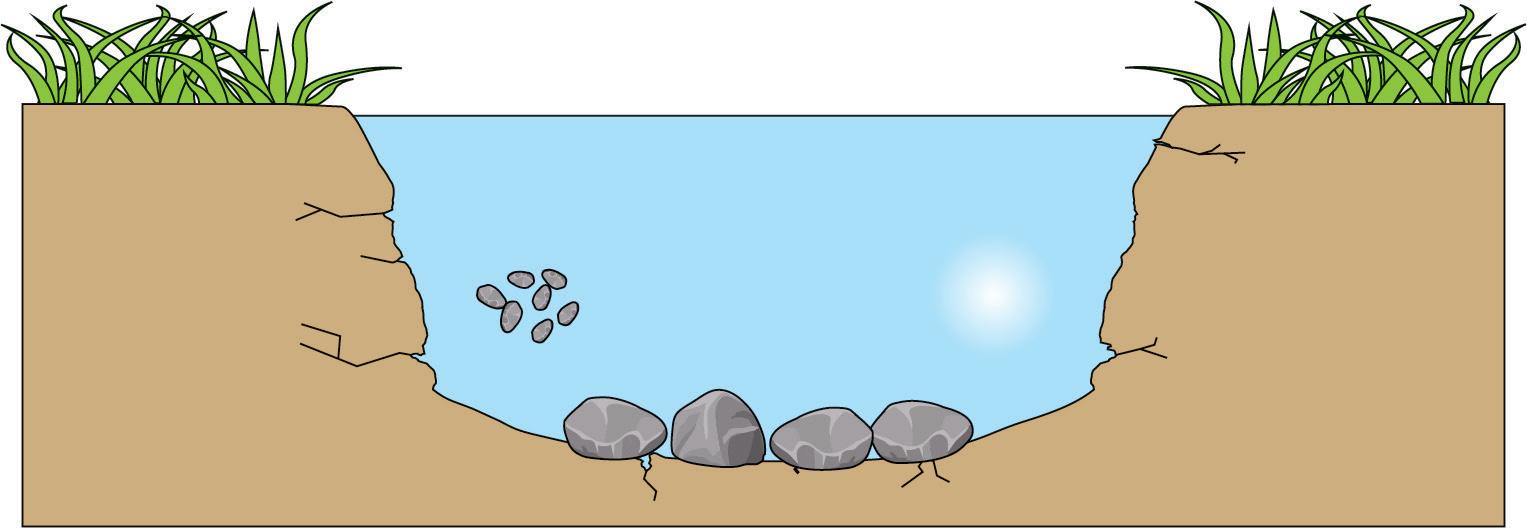
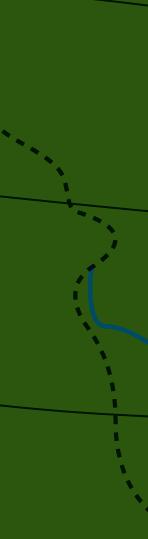
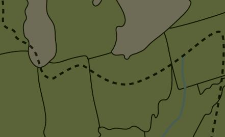
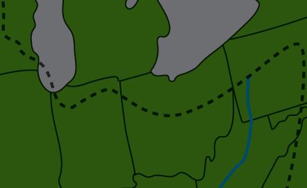
Rivers flow within drainage basins. The drainage basin is an important part of the hydrological cycle, moving water from upland areas towards the sea. The edge of a drainage basin is marked by the watershed, which is usually found on higher ground. This acts as a dividing line, where precipitation falling one side of the watershed flows into one drainage basin and water falling the other side flows into another. Most of the Earth’s surface is covered in a network of connecting drainage basins.
Drainage basin: an area of land that is drained by a single river and its tributaries.
Source
Watershed
Confluence
Drainage basin: The area of land drained by a river and its tributaries.
The river within a drainage basin rarely follows a single path. Smaller streams, or tributaries, feed into the main river channel. A confluence is found where two main channels meet.
Several processes operate within a drainage basin which determine the flow of water through the system. These include:
Precipitation water that moves from the atmosphere to the land, e.g. rain and snow
Interception vegetation prevents precipitation from reaching the ground
Infiltration surface water soaks into the surface of the soil
Percolation water moves through the soil and rocks
Throughflow water from the soil moves into rivers and streams
Groundwater flow water stored deep underground moves into rivers and streams
Evaporation water stored on the surface moves back into the atmosphere
Transpiration intercepted water moves back into the atmosphere
Evapotranspirationwater moves back into the atmosphere by evaporation and transpiration
Overland flow water runs over the surface and into rivers and streams
Channel flow water is transported by rivers and streams
Table 1.1: Processes operating in the drainage basin
TASK 3: Study Source E
a Explain why the watershed is found on higher ground.
b Explain why river discharge increases between the source and the mouth.
Precipitation Interception
Evapotranspiration
Source F : Processes that operate in a drainage basin
An understanding of rivers and drainage basins is important for managing water resources, preventing flooding, and preserving ecosystems.
TASK 4: Study Source F
Drainage basins are open systems, which means that water can enter or leave the basin.
a Explain how water enters the drainage basin system.
b Explain how water leaves the drainage basin system.
TASK 5
Work in pairs. Imagine you were travelling in a boat from the source of the river to the mouth. Describe your journey. Think about things like the landscape around you and the speed at which you’re travelling. Once you’ve finished writing your journey, join up with another pair from the class and share your stories. Peer‑assess one another’s work.
The differences in a river between the source and the mouth are easier to remember once you understand why the changes take place. Think about why rivers become wider and deeper, and why the velocity and the discharge increase. Does understanding how the processes work help you to remember the differences between the different parts of a river? Do you think this approach will help you in other geographical topics?
Erosion is the wearing away of the landscape. River erosion is a process that occurs as rivers flow over the land. There are four main types of river erosion:
• abrasion
• hydraulic action
• attrition
• solution
a Work in pairs to create diagrams to show how each type of erosion works. You might be creative about this, for example, the diagram for ‘solution’ could show sugar being dissolved in a cup of coffee.
b Share your diagrams with another pair in the class. Which pair created the best diagrams and why?
Source A : Rivers erode the landscape around them
Abrasion: when the load of a river rubs against the riverbed and riverbanks, wearing them down over time.
Hydraulic action: when the force of moving water removes rocks and sediment from the riverbed/seabed and riverbanks.
Attrition: when particles carried by a river/sea collide and break into smaller pieces.
Solution (erosion): a form of erosion which occurs when chemicals in the river water dissolve certain rock types, like limestone.
The rate, or speed, of river erosion is influenced by several factors, including:
• the gradient of the river – steeper slopes lead to greater levels of energy, which generally leads to faster rates of erosion
• the size and type of sediments transported by the river – larger and more abrasive materials, such as sharp rocks, can increase rates of erosion
• the geology, or type of rock, that the river flows over – softer rocks, such as mudstone, erode more quickly than harder rocks, such as granite.
a Suggest which types of river erosion could take place in this location.
b Identify evidence within the image to show that the river is eroding the landscape.
Transportation is the process by which rivers move eroded sediments and materials downstream. This happens in four main ways:
• Traction: large boulders and rocks are pushed, dragged, or rolled along the riverbed by the force of flowing water. Traction usually takes place near the source of a river and it involves large rocks that are too heavy to be picked up. Moving bedload by traction requires a lot of energy.
• Saltation: small pebbles and stones are lifted and carried by the flow of the river. They are too heavy to be suspended in the water for long periods of time, so they fall back down to the riverbed. This means they appear to bounce along. Saltation is more common closer to the source of a river, where bedload size is greater.
• Suspension: fine sediment particles, such as silt and clay, are carried along by the river. These particles remain suspended (carried) in the water because they are small and light, which means they can easily be carried along. Suspension is more common closer to the mouth of a river, where bedload size is very small.
• Solution: soluble minerals from rocks and sediments are dissolved within the water. These particles are so small that they require very little energy to transport and the river carries them over great distances. Solution typically takes place closer to the mouth of a river, where very fine material is found.
Create a copy of the table below. Add these words to the table in the correct places:
traction suspension very large small saltation solution large fine
Gradient: the degree to which the land slopes. Hills have steep gradients and flat land has a gentle gradient.
Geology: the type of rock found within a given area.
Traction: when large boulders and rocks are pushed, dragged, or rolled along the riverbed/ seabed by the force of flowing water.
Saltation: when small pebbles and stones appear to bounce along the riverbed/seabed.
Suspension: when fine sediment particles, such as silt and clay, are carried along by the river/sea.
Solution (transportation): a form of transportation which occurs when soluble minerals from rocks and sediments are dissolved within the water.
Type of transportation
Size of bedload
1.2: The processes of river transportation
Deposition occurs when a river drops or deposits sediment it has been carrying. This takes place when the river’s velocity decreases and it has less energy to transport its load. Many different things can lead to a loss of energy, such as:
• where the river channel bends and water flows more slowly on the inside of the bend
• when a river enters a larger body of water, like a lake or the ocean, and slows down
• when a river floods over large areas of land and temporarily resembles a lake.
A river deposits larger and heavier material first because it requires more energy to carry. A river can usually transport finer and lighter material much further. The finest river sediment is called alluvium. It is a very fertile material that is deposited across floodplains following a flood.
1.3: The river deposits larger pebbles and stones first
Erosion, transportation, and deposition work together to move material along the course of a river. Erosion wears away the landscape and provides material, transportation carries this material downstream, and deposition settles it in new areas. In this way, rivers are continuously redistributing material.
Solution is a process of erosion and transportation. Within erosion, minerals and fine sediment are dissolved into a solution. Within transportation, minerals and fine sediment are moved in solution form.
How did you decide where to place the words listed in Task 3? Did you check the text from the transportation section, or did you work out the answers by thinking about how transportation works? Understanding how processes work will help you to remember key facts.
Alluvium: river sediments, such as silt and mud.
Erosion
•Abrasion
•Hydraulic Action
•Attrition
•Solution
Transportation
1.4: River processes work together
•Traction
•Saltation
•Suspension
•Solution Deposition
State how gravity is important for all three river processes.
Decreasing gradient and elevation
and deposition Predominantly erosion
Cross profiles
Figure 1.5: River long and cross profiles
River valleys are formed by the continuous processes of flowing water over time. The long profile of a river shows how the river’s gradient and elevation change along its course. It typically consists of the upper, middle, and lower courses (Figure 1.5).
The shape and characteristics of a river valley vary along the long profile:
Annotated diagrams can be a useful way of explaining your ideas. Try using diagrams to explain why gravity is an important factor in river processes.
Elevation: height above a given level, for example, metres above sea level.
• In the upper course, the high elevation leads to vertical, or downwards, erosion. This takes place when the force of gravity, combined with the kinetic energy (energy that is created by movement) of flowing water, enables the river to cut vertically into the landscape. Vertical erosion creates steep V-shaped valleys. As the river flows through V-shaped valleys, interlocking spurs form (Figure 1.6). Interlocking spurs are ‘fingers’ of harder rock which are harder to erode. This land juts out and the river meanders around it.
Figure 1.6: A V-shaped valley with interlocking spurs of land
• As the river progresses to the middle course, the elevation decreases. Lateral, or sideways, erosion becomes more significant. This is because the river is closer to sea level, but it still has a lot of energy.
• In the lower course, the valley is wide and flat. Some lateral erosion continues. Sediments deposit on the valley floor, creating fertile floodplains.
The cross profile of a river refers to the cross-sectional view of the valley. It typically consists of the river channel, the riverbanks, and the land either side of the river.
The cross profile in the upper course shows a narrow river channel and V-shaped valley sides. By the lower course, the river channel is wider and deeper, and the valley sides are flat and wide (see Figure 1.5).
a The table opposite contains data that students collected on a fieldtrip about the depth of a river. Use the data to draw a cross-section of the river channel. The x axis should be distance across the channel in cm and the y axis should be depth of the river in cm. The y axis should have 0 at the top and 15cm at the bottom.
b Suggest which course of the river this data has been collected from.
c Explain your answer to part b.
Long and cross profiles are easily confused. Try putting an ‘a’ in front of the words to help remember them. Long profiles are ‘a long’ the length of the river. Cross profiles are ‘a cross’ the river.
The river processes of erosion, transportation, and deposition create different landforms. These landforms typically occur in different parts of the river, according to which processes are dominant.
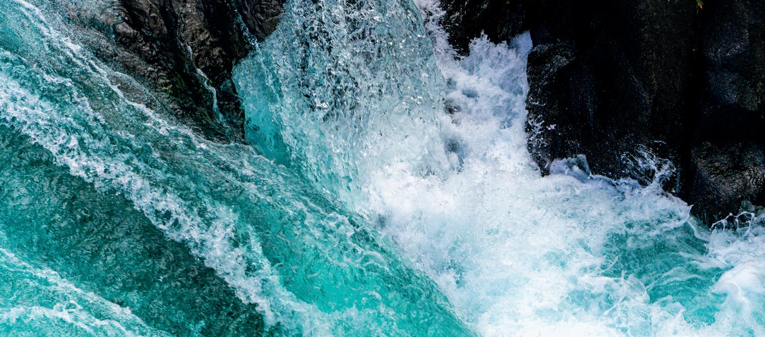
In the upper course of a river, the gradient is steep, and the water is shallow. Potholes are cylindrical depressions in the riverbed. They form through the process of abrasion as the material carried by the river scours the riverbed, eroding vertically into the rock. Rapids are turbulent sections of a river with fast-flowing water. They form when water encounters obstacles like rocks or alternate bands of hard and soft rock along the riverbed. These obstacles disrupt the flow of the river. This creates turbulence, or whitewater. Higher water levels due to rainfall or snowmelt can make rapids more powerful.
Waterfalls are features where water cascades over a vertical drop in the landscape. They are found where a river flows over bands of hard and soft rock. The river erodes the rock through processes such as hydraulic action and abrasion. The softer rock erodes faster than the harder rock. This creates a drop in the level of the land beneath the river.
When the waterfall is well established, the force of the water plunging over the drop can undercut the hard rock. Eventually the hard rock cannot support itself and it breaks off, falling into the plunge pool below. The force of the falling water, along with the abrasive power of the hard rock fragments, can create a deep plunge pool.
Potholes: cylindrical depressions in a riverbed created by abrasion.
Rapids: steep sections of a river where shallow, fastflowing water lead to turbulence.
Waterfall: water flowing over a ledge of harder rock.
Source A : The formation of waterfalls
This cycle of erosion and undercutting leads to the backward movement upstream, or retreat, of the waterfall. As the waterfall retreats, it leaves a narrow valley. This is called a gorge
Waterfall retreats
Gorge: a narrow valley that forms when a waterfall retreats upstream.
Source B : A waterfall and gorge
TASK 1: Study Sources A B
Re‑order the statements below to explain how waterfalls and gorges form:
• The cycle of erosion and undercutting leads to the retreat of the waterfall.
• A gorge is created where the waterfall once flowed.
• Water plunges over the edge of the hard rock creating a plunge pool in the soft rock.
• The softer rock becomes lower than the harder rock.
• The hard rock is undercut.
• The hard rock becomes unsupported and breaks off.
• The river flows over bands of hard and soft rock.
• Hydraulic action and abrasion erode the softer band of rock.
• Fragments of hard rock increase rates of erosion in the plunge pool.
Meanders are curves or bends in a river, typically found in the middle and lower courses of a river where lateral erosion is dominant. The flow of a river is rarely straight because water flows around more resistant parts of the landscape.
As a river winds its way through the landscape, the speed of flow is not even across the channel:
• The outside of the bend has a quicker flow because of centrifugal forces, which push water towards the outer bank. This creates energy, increasing rates of hydraulic action and abrasion.
• The inside of the bend has a slower flow and deposition takes place as the river has less energy. Over time, deposited sediment builds up, creating a gently sloping bar.
Meander: a bend in a river, usually found in the lower or middle courses.
Centrifugal force: a force that causes a river flowing around a bend to move out and away from the centre of the channel.
Cambridge Pathway.
As the river continues to erode on the outside bank and deposit on the inside bank, meanders become progressively wider.
Oxbow lakes are curved, often u-shaped, bodies of water that are separated from the main river channel. They are the remnants of meander bends that have grown so wide that they become cut off. If the neck of a meander becomes too narrow, the river is able to cut through and follow a shorter route. Water in the old meander bend is called an oxbow lake. Water no longer flows and the lake may fill with sediment and vegetation or dry up completely.
Oxbow lake: an isolated section of water that is left behind when a meander bend becomes cut off.
Re order the statements below. Then, use them to create a flow diagram to explain how meanders and oxbow lakes form:
• This creates deposition on the inside bend.
• The river naturally curves around more resistant features of the landscape.
• The remnant meander becomes an oxbow lake.
• Centrifugal force pushes water to the outside of the curve.
• At the same time, water flows more slowly on the inside of the curve.
• The meander becomes more pronounced over time.
• This increases rates of erosion on the outside bend.
• When the neck of the meander becomes too small, the river breaks through creating a shorter route.
A floodplain is an area of flat or gently sloping land beside a river or stream, usually in the middle or lower courses. During times of high discharge, river levels rise and water flows out of the channel and onto the floodplain. As water spreads across the floodplain, it experiences more friction and loses its energy. This leads to the deposition of alluvium. Over time, repeated flooding builds up layers of sediment on the floodplain.
Levees are raised embankments found on floodplains running alongside rivers. As rivers spill onto floodplains, the loss of energy can be almost immediate. This means greater levels of deposition take place at the side of the riverbank. Over time, these layers of deposited sediment build up and become levees, which are higher than the rest of the floodplain.
To remember the location of a river landform, think about the direction of erosion that takes place:
• Vertical erosion, such as with waterfalls, takes place in the upper course.
• Lateral erosion, such as with meanders, takes place in the middle and lower courses.
How can you remember the direction of erosion? Is there anything about each landform that gives a clue to the type of erosion found in that location?
Floodplain: a flat area of land found beside rivers in the middle and lower course.
Levee: higher areas of land found beside a river.
E : The formation of levees
Source F : A floodplain during times of flood
Work with a partner to create a table of advantages and disadvantages of floodplains and levees.
Deltas are landforms at the mouths of rivers, formed through the build-up of deposited material. They often take a shape of a bird’s foot (for example, the Mississippi river delta in the USA) or a fan (for example, the Nile river delta in Egypt).
In the lower course, large amounts of sediment are transported by the river. When the river flows into the sea, its velocity decreases dramatically, and it loses the energy it needs to transport its load. Larger, heavier particles require the most energy to transport, and so they are deposited first. Smaller, lighter particles travel further before being deposited. Over time, vast quantities of sediment build upwards and outwards into the sea.
If sediment blocks the main channel, the river divides into distributaries (Source G). Bars or islands of land consisting of deposited material are found between the distributary channels.
Delta: a depositional landform found at the mouth of a river.
Distributaries: smaller channels that flow away from the main river, often found in deltas.
We are working towards endorsement of this title for the Cambridge Pathway.
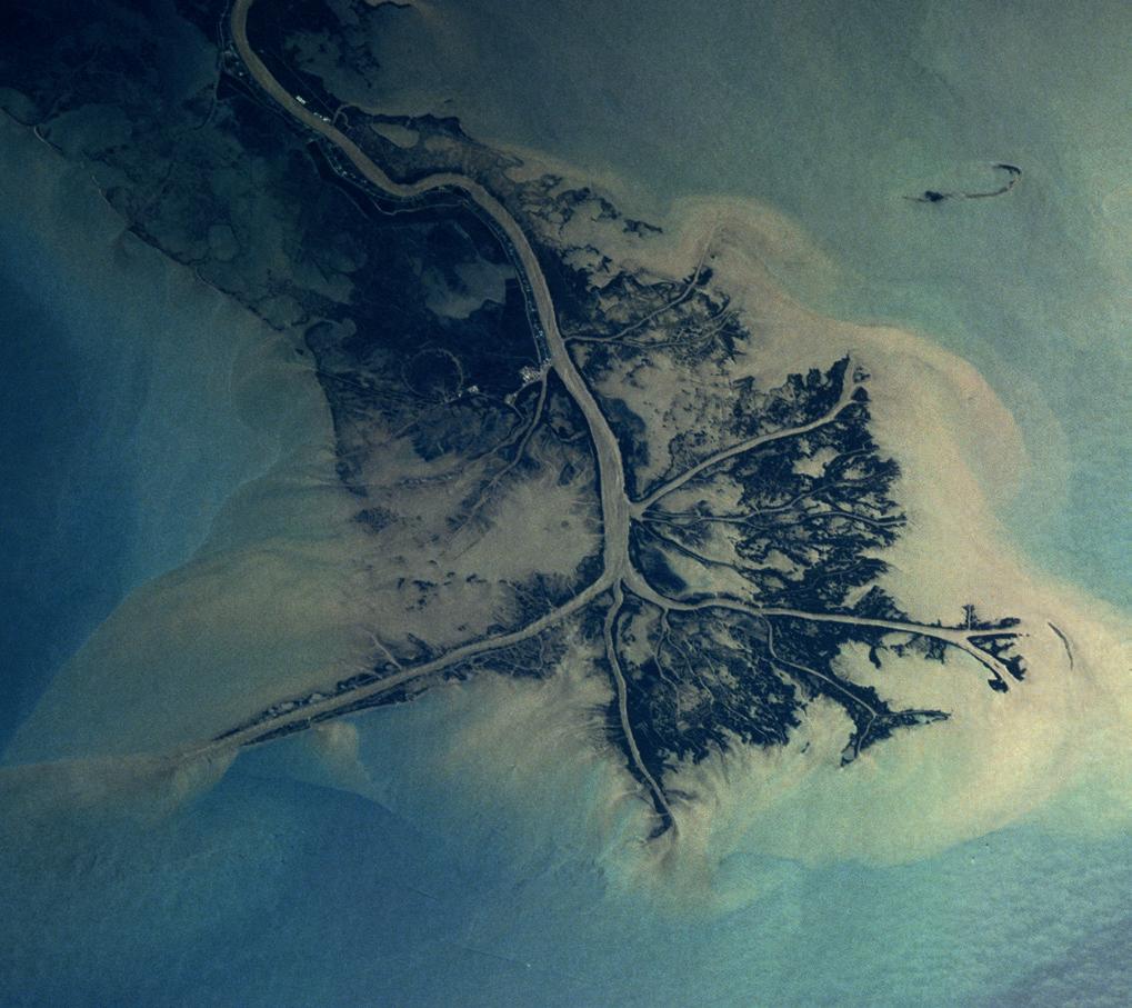
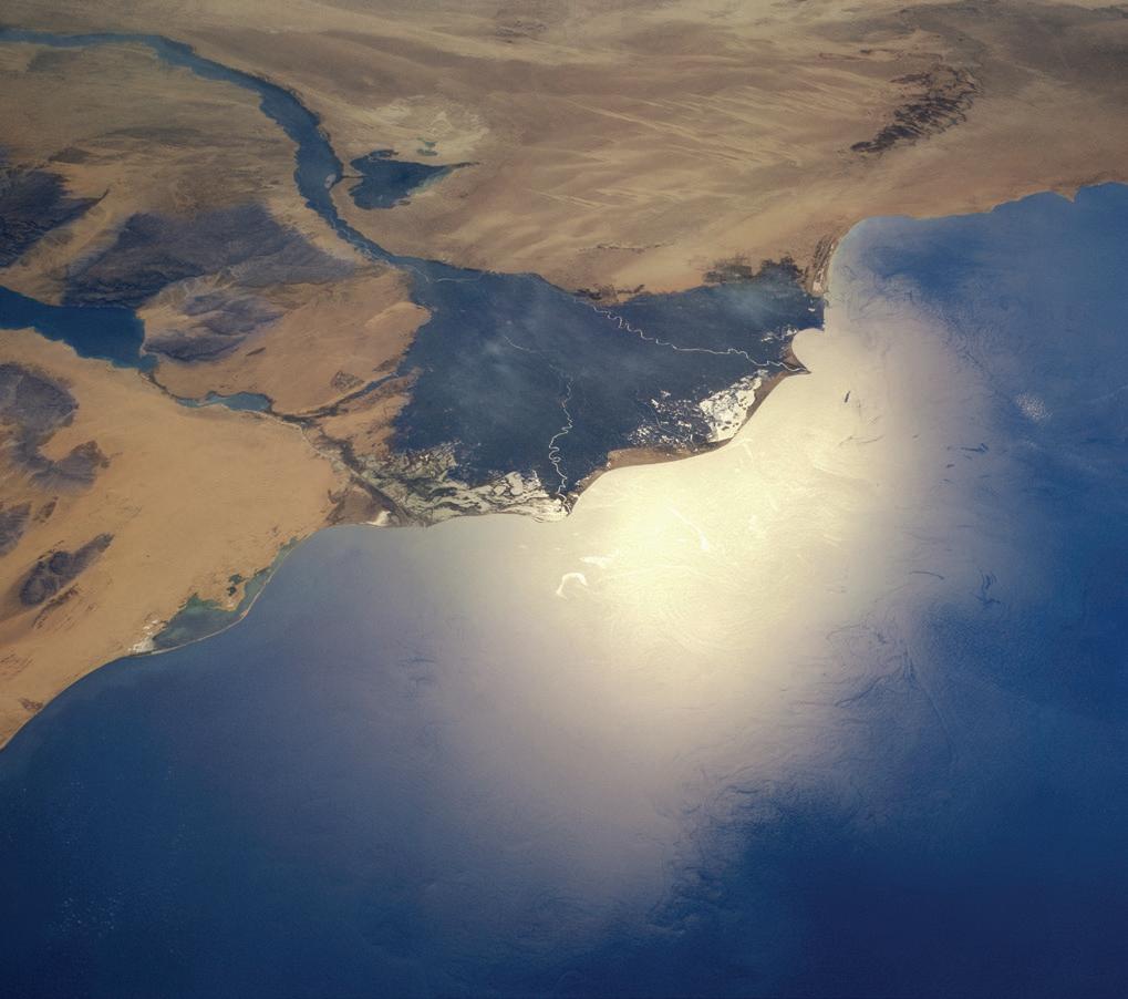
a Identify which image shows a fan delta, and which shows a bird’s foot delta.
b Make a sketch of the Mississippi delta and label the following features:
a Main river channel
b Distributaries
c Deposition of finer sediment
d Deposition of larger sediment
e Islands or bars
f The land
g The sea
h The direction of river flow
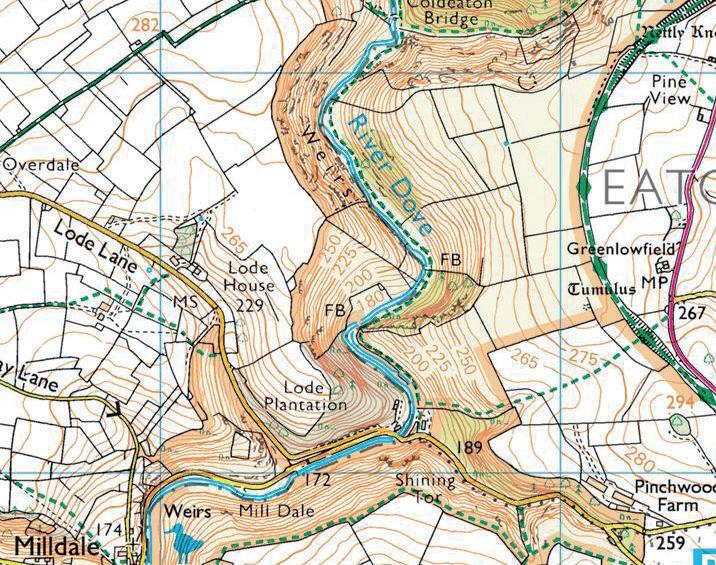
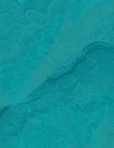
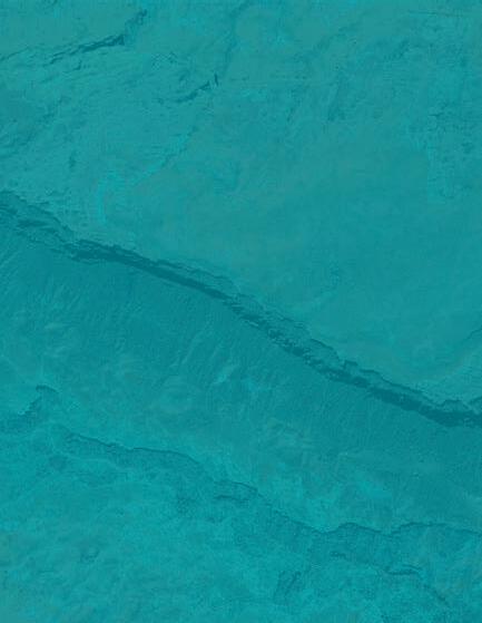
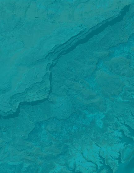
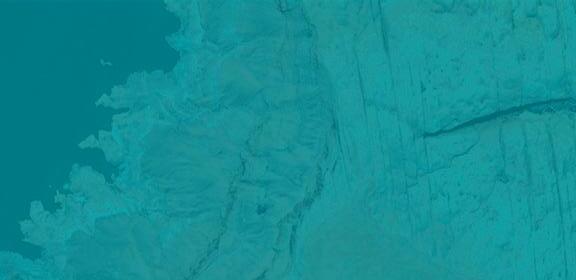
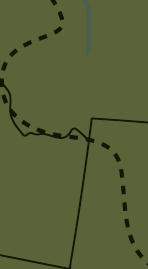
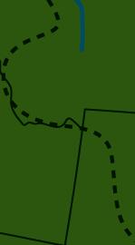
a Suggest which part of the River Dove is most likely to be in the upper course. Explain why you think this.
b Suggest which part of the River Dove experiences vertical erosion and which experiences lateral erosion. Explain why you think this.
c Identify as many river landforms as you can from Source I.
d Predict how the river in Source I might change over time.
Living near a river can offer various opportunities. These include:
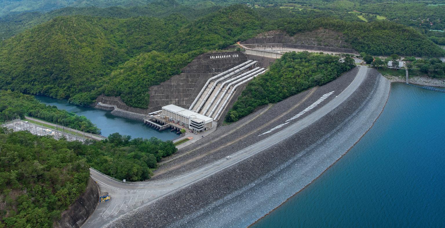
• Water supply: rivers provide fresh water that can be used for drinking, irrigation, and industry.
• Energy: hydroelectric power (HEP) is produced when flowing water is used to turn turbines, generating electricity. Small and large HEP stations can provide a sustainable and renewable energy source.
• Transportation: rivers can support the movement of people and goods. In some parts of the world, people still rely on rivers for trade and transportation.
• Recreation: leisure activities such as fishing, boating, and swimming can improve peoples’ mental and physical health. These activities can also provide an income for local people and contribute to a region’s tourism industry.
a Explain how the water in the lake at the top is replenished.
b Suggest why HEP might be considered better than burning fossil fuels.
c Identify any potential disadvantages to HEP.
Living near a river can also bring hazards. Rivers can burst their banks and flood the surrounding landscape, particularly during times of heavy rainfall or snowmelt. Continuous erosion by rivers can lead to the loss of valuable land, such as farmland, private properties, and infrastructure. Industrial discharge, runoff from farmland, and sewage can also contaminate rivers and pose health risks.
a Can you think of any more opportunities and hazards associated with rivers?
b Identify which opportunities and hazards associated with rivers: i differ between different countries ii change over time Explain how.
River flooding has natural and human causes. Examples of natural causes of flooding include heavy rainfall and rapid snowmelt. Humans can also create floods or make them worse. Activities such as deforestation and urbanisation decrease the amount of rainfall that can infiltrate and percolate into the landscape, increasing run-off. Climate change is also leading to higher rates of snowmelt and increased rainfall in some places, both of which can cause flooding.
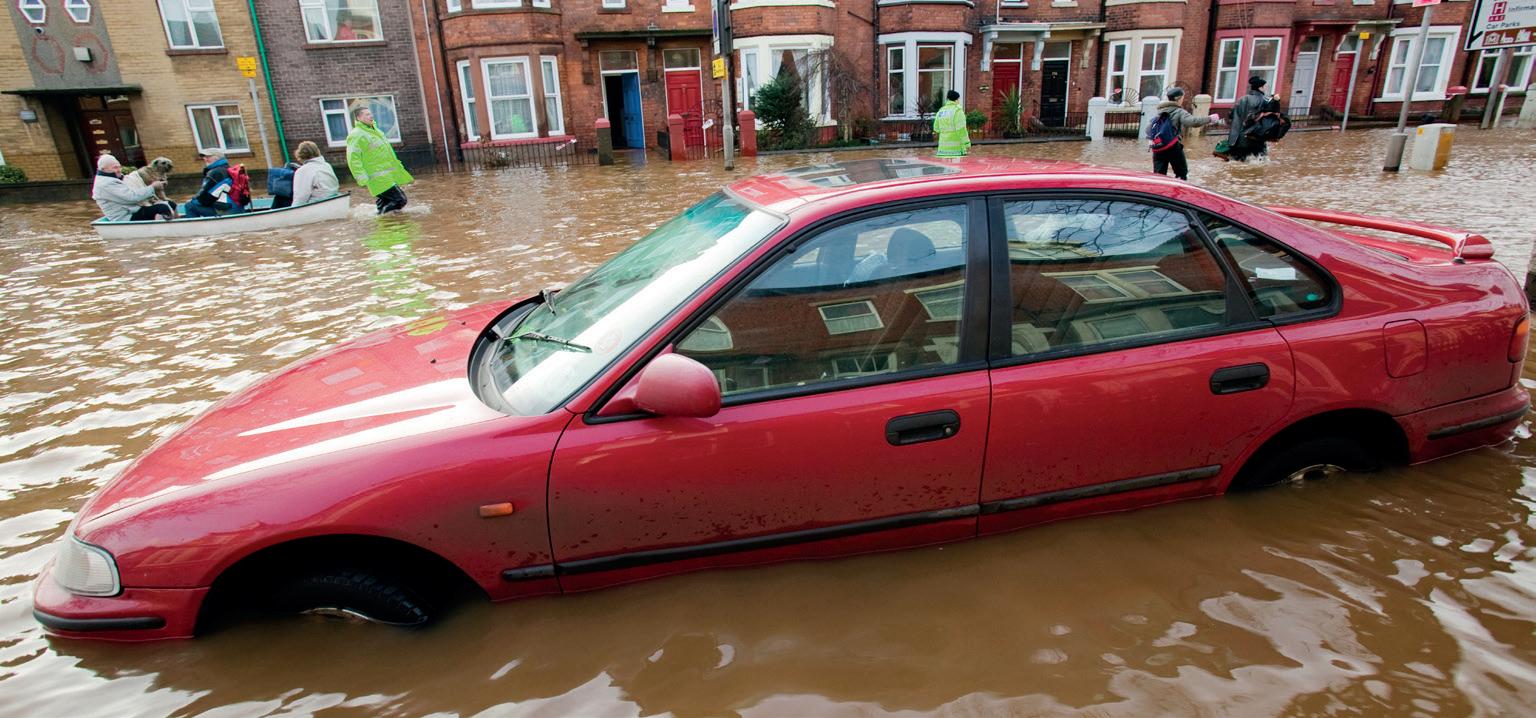
Source B : Flooding in Cumbria, UK
Infrastructure: facilities and systems that allow a place to function, e.g. transportation, energy, and public buildings.
Urbanisation: an increase in the proportion of people living in towns and cities.
a Work with a partner. Describe the damage that can be seen in the image.
b List the ‘costs’ of – or damage from – flooding under the following headings:
i Social
ii Economic
iii Environmental
iv Peer assess the answers of another pair in the class by comparing their answers with yours. Are there any areas where your answers differ and, if so, why?
River pollution usually takes place because of human activities. Sources of river pollution can be accidental or intentional. They include industry and agriculture, such as the use of pesticides and fertilisers and the release of sewage into waterways.
Both river flooding and pollution can have social, economic, and environmental impacts (Table 1.2). These are usually small in scale, affecting local or regional areas. They can also have larger-scale implications, such as the destruction of crops for export to other countries. Whilst the impacts of flooding and pollution are largely negative, flooding can be positive as sediment deposited by floodwater acts as a natural fertiliser for farmland and can be beneficial for migrating species of birds.
Social
Economic
Environmental
• risk to human health, such as exposure to sewage leaks and contaminated floodwaters
• displacement of people
• fatalities and injuries.
• damage to property and disruption to infrastructure, leading to economic losses
• damage to crops, leading to economic losses.
• habitat destruction and soil erosion caused by the force of the floodwater.
Table 1.2: Impacts of river flooding and pollution
• threats to human health
• shortage of drinking water
• shortage of water for irrigation.
• cost of cleaning up polluted watercourses and restoring affected ecosystems.
• damage to aquatic ecosystems and loss of biodiversity.
Humans can implement strategies (management plans and agreements) and techniques (management methods) to reduce the risk of flooding and to ensure water quality in rivers. Sustainable river management involves both strategic planning and the use of specific techniques, whilst also considering environmental conservation, such as restoring and protecting the natural landscape and ecosystem.
Flood prevention strategies involve agreements to zone floodplains to prevent development or plans for river restoration. Techniques to prevent flooding include hard engineering and soft engineering. Hard engineering strategies tend to reduce flooding very quickly, but they can be expensive to build. Soft engineering strategies are generally considered to be more sustainable as they cause less disruption to nature.
It can be easy to confuse hard and soft engineering techniques. Hard techniques often use physically hard materials, such as concrete and steel. Soft techniques generally use softer materials, like vegetation. This rule doesn’t always work – for example floodplain zoning does not use ‘materials’ at all – but it can be a good place to start.
Hard engineering: flood management techniques that work against nature.
Soft engineering: flood management techniques that work alongside nature.
Afforestation: planting trees in an area that has not recently had tree cover.
Channelisation: straightening, widening, or deepening rivers so that they can hold more water.
Floodplain zoning: ensuring land uses that are temporary or of lower value lie beside the river where there is greater risk of flood.
River restoration: reversing changes that humans have made to the river to reduce flood risk downstream.
Source C : Strategies and techniques to reduce flooding
Managing river pollution ensures water quality and protects ecosystems. Strategies for managing river pollution include the implementation of laws to protect rivers. This protection can be achieved using several different techniques:
• treating wastewater, such as sewage, before releasing it into rivers
• monitoring the quality of water in rivers to detect and deal with pollution
• fining companies and individuals that release contaminated water
• educating companies and individuals about the dangers of water pollution.
In groups, carry out a class debate. Half of the class should be ‘for’ hard engineering and the other half should be ‘for’ soft engineering strategies. You must consider social, economic, and environmental impacts of the techniques. Within your groups, you could take on specific roles (for example, residents, local business owners, tourists, environmentalists, the local council, and engineering companies).
How does Source C help you to remember and understand hard and soft engineering strategies and techniques? What other information from the ‘river flooding and pollution’ section could be turned into a diagram?
Many people work in jobs planning and building flood defences. What could their roles be? These jobs can be within local communities or at a government level, and in some places, they are becoming more important because of the impacts of climate change. What types of skills might be needed for this line of work? Do you have those skills?
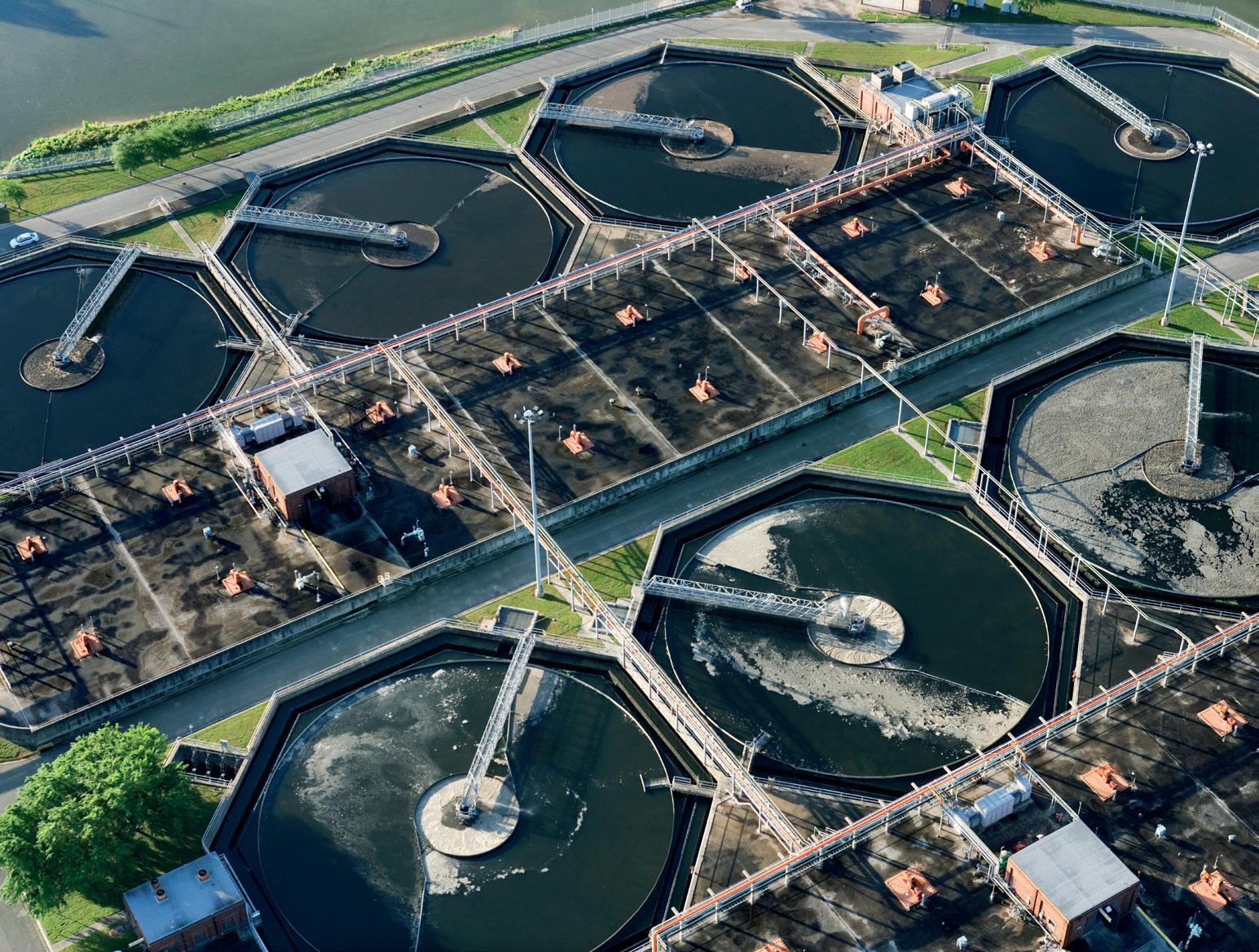
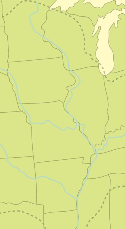
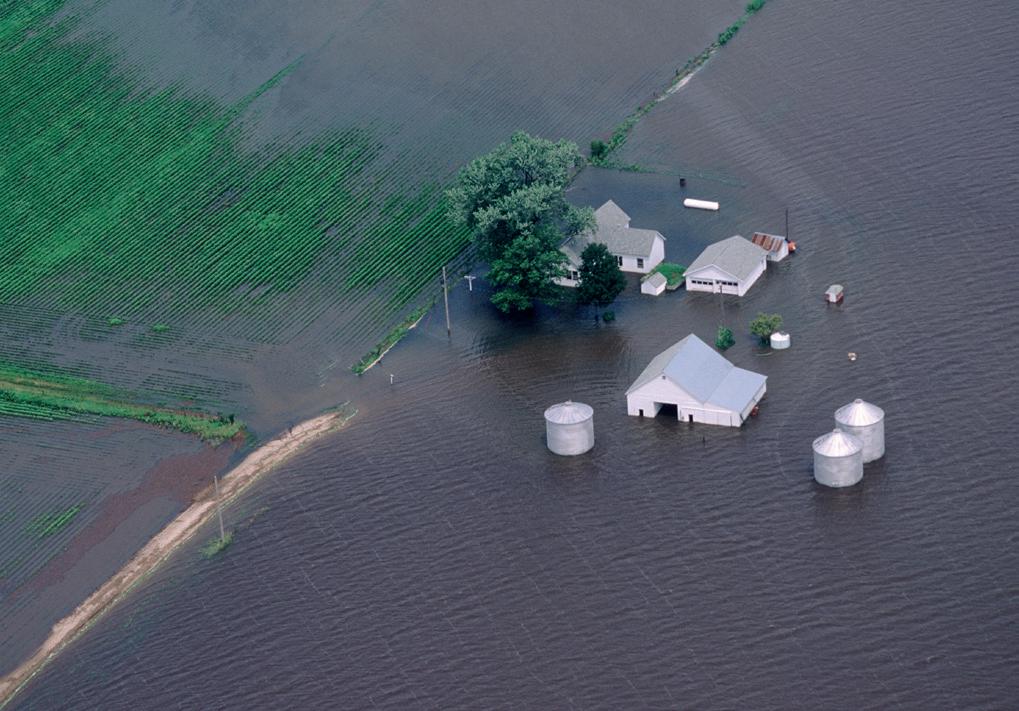
The Mississippi River in the USA is the largest river in the North American continent. Its drainage basin extends over 31 states, covering around 15% of the land area of North America. The river and surrounding basin are economically important; they are used for agriculture, transportation, and the provision of clean water and energy.

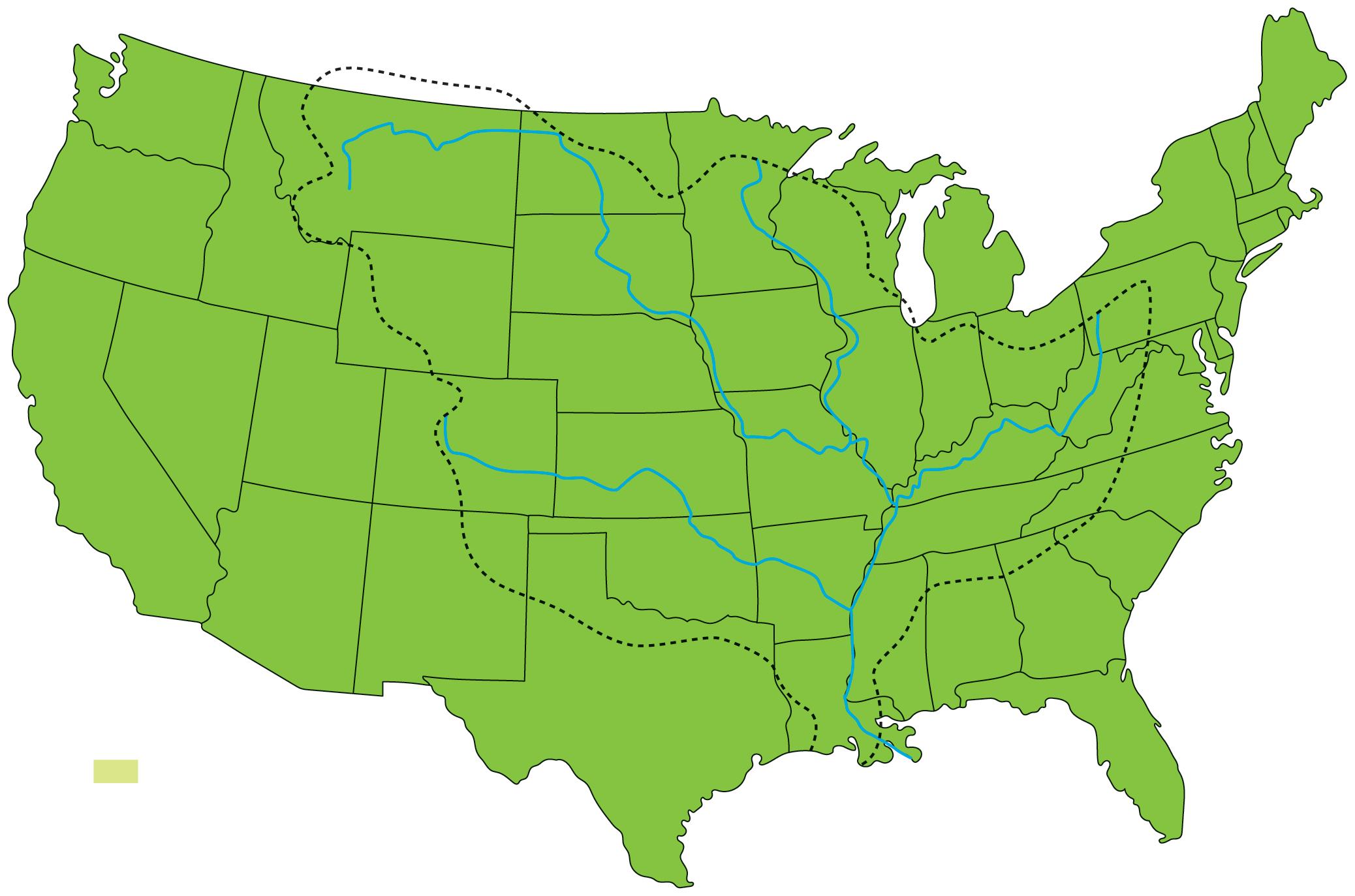
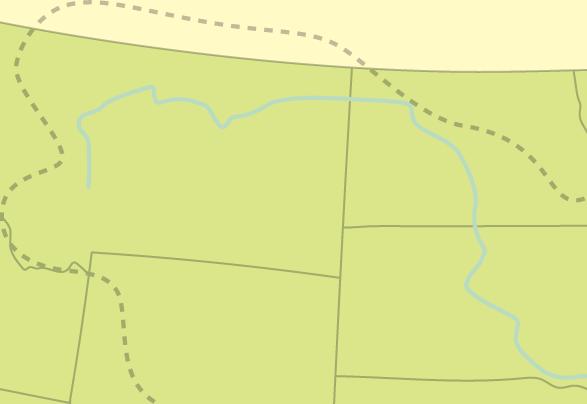
Source A : The Mississippi River basin
TASK 1: Study Source A

The Mississippi River experiences frequent and sometimes devastating floods. This is not a new trend; flooding has always taken place along the Mississippi, and the Great Mississippi Flood of 1927 remains one of the most destructive in the country’s history.
Discuss in pairs why the Mississippi’s tributaries contribute to flooding downstream.
1200
1543
Archaeological records suggest the Native American settlement of Cahokia was devastated as a result of flooding.
Explorers encountered a flood lasting over 40 days.
1734 to 1735 December to JuneCity of New Orleans was flooded for several months.
1851June
Major flooding due to excessive rains in Iowa.
1874February to MayThe Great Mississippi Flood of 1874. 375 000 homes and over 12 000 000 acres of land affected.
1882February
1912March to May
1913April to May
1927January to May
Around 20 000 people made homeless in the state of Arkansas alone.
Heavy snowfall quickly melted, which caused extensive flooding along the Mississippi and its tributaries.
One of the worst floods in US history. It is estimated that around 1000 people lost their lives.
The Great Mississippi Flood of 1927. Floods lasting 135 days. Persistent rainfall caused floodwaters to span nearly 130 km in places.
1937February to MarchThe Great Mississippi Flood of 1937. Heavy rainfall and snowmelt led to the Mississippi river exceeding previous flood records.
1973March to May
2011March to June
The largest volume of water to flow down the Mississippi since the 1927 flood.
The Great Mississippi Flood of 2011. Caused by snowmelt and heavy rains in the Ohio Valley.
2019Dec 2018 to Aug 2019The longest known flood on record of the lower Mississippi River, lasting for 226 days.
Source B : Important Mississippi flood events over time
a Create a bar graph to show the months that have been affected by flooding over time. For example, the 1874 flood affected February, March, April, and May.
b Which months are the most likely to be affected by flooding?
c Which months are the least likely to be affected by flooding?
d Suggest why some months have a greater potential for flooding than others.
Cambridge Pathway.
Natural causes of flooding along the Mississippi include heavy rainfall and snowmelt, particularly during the spring months. The river has numerous upstream tributaries, including the Arkansas River and the Ohio River. The volume of water flowing along these tributaries adds to rising water levels.
Human causes of flooding include urbanisation and deforestation, which lead to an increase in surface run-off. An estimated 70 million people live within the Mississippi drainage basin in cities such as New Orleans, Minneapolis, and Memphis. Large areas of land have been cleared to make way for agriculture. In addition to this, the impacts of climate change have made the natural causes of flooding worse. (see Topic 5 for more about this).
Flooding along the Mississippi leads to property and infrastructure damage, loss of life, displacement of communities, and loss of income. Flooding can have social, economic, and environmental consequences, for example:
• The Great Mississippi Flood of 1927 caused 246 deaths and left over 700 000 people homeless. The damage to property was estimated to have cost over 400 million.
• During the 2011 flood, deer, wild turkeys, alligators, spiders, rats, and even fire ants were swept away by the waters. The Tennessee government released guidance for residents to avoid displaced snakes.
• The 2019 flood prevented 5.2 million tons of corn and 1.1 million tons of soybeans (valued at $973 million) from being transported.
C : Flooded farmland in the Mississippi Basin
3: Study Sources C D
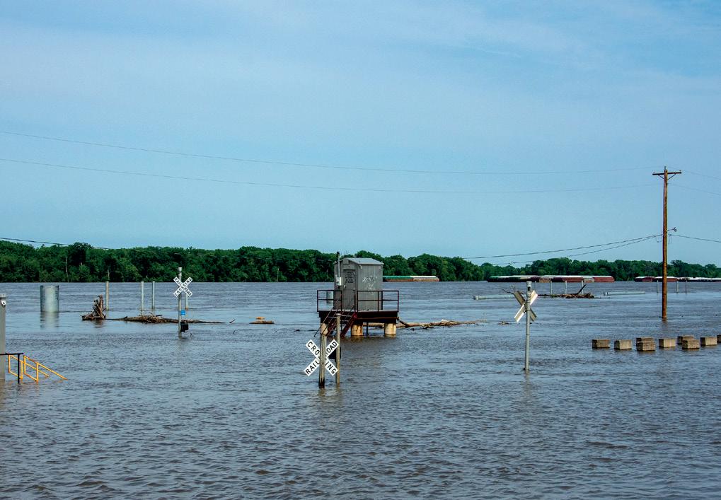
Source D : Flooded infrastructure in the Mississippi Basin
Explain the social, economic, and environmental costs caused by this flood.
Work in pairs or small groups to design a flood resistant infrastructure or housing concept. Research elements like raised foundations, drainage systems, or materials resilient to water damage. Develop a plan and be prepared to present your ideas to the class in a 5 minute pitch. Use sketches to support your presentation and explain the benefits of your proposed solution.
Since the 1700s, attempts to control flooding in the Mississippi Basin have involved the use of levees and floodwalls to increase the capacity and speed of the river. These techniques are controversial because they prevent the river from flowing onto the floodplain, which can push greater volumes of water to areas downstream.
Between 1929 and 1931, the Bonnet Carré Spillway was constructed close to the city of New Orleans. The spillway can divert 250 000 cubic feet of water per second away from the river into nearby Lake Pontchartrain and out to the Gulf of Mexico.
In recent years there has been a move towards sustainable approaches to flood management along the Mississippi. Sustainable management strategies and techniques work with, rather than against, nature. They include:
• Floodplain management: restricting construction in flood-prone areas and restoring natural floodplains and wetlands. A recent study in Illinois found that losing just 1% of wetlands can increase flood volumes by as much as 7%. State and federal governments have bought frequently flooded agricultural areas of floodplain to use as flood storage areas. Since 2019, landowners have been able to also apply for compensation to convert farmland back to floodplains and wetlands.
• Drainage basin management: focusing on land-use practices, such as reforestation, which decrease run-off and reduce the volume of water reaching the river. The Wetland Reserve Enhancement Partnership (WREP) programme offers incentives to encourage landowners to carry out reforestation.
• Early warning systems: monitoring and prediction systems can provide flood alerts, enabling people to prepare. The US National Weather Service has webpages providing information about current and potential river levels and flood risk along the Mississippi.
Reforestation: replanting trees in an area where they have previously been cut down.
• Community resilience: developing flood-resistant infrastructure and creating disaster preparedness plans. The Federal Emergency Management Agency (FEMA), part of the US government, has a Building Resilient Infrastructure and Communities (BRIC) programme. This supports projects such as the Greenprint for Resilience project in Shelby County, Tennessee, which has created elevated roads and bought vulnerable homes to convert land back to wetlands.
When learning about sustainable flood management, focus on real world examples to understand how different strategies and techniques have been successful.
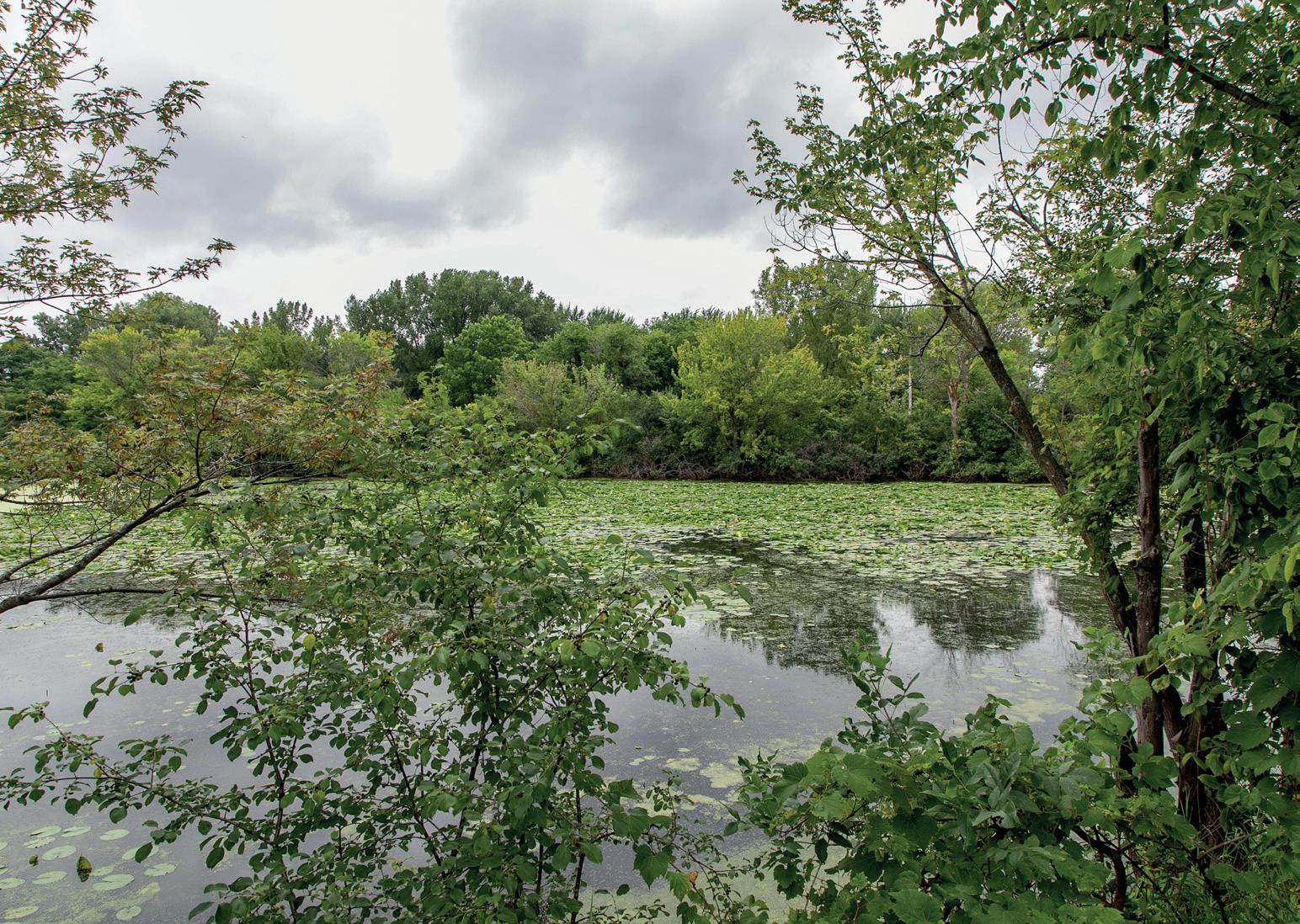
Figure 1.10: Wetlands store water at times of high flow

‘It has to be dealt with’: what’s the future for midwest towns affected by climate change?
The city of Davenport is grappling with more than 50 days of flooding after the Mississippi spilled over its banks, broke through a barrier and washed into downtown. The streets of smaller cities to the south, such as Buffalo, were underwater for days. “Between hurricanes, tornadoes, floods and droughts, literally all within a year, something’s changing,” said Davenport’s mayor, Frank Klipsch.
Klipsch said the old response would have been to build a higher flood wall. “But you step back a little and that isolationism isn’t necessarily the best approach today,” said Klipsch. “The river is not one city but a whole system in of itself so that whatever one city does it impacts others along the river. One of our small cities, Buffalo, just south of us, had tremendous flood problems now. If we were to put up a flood protection wall it would basically funnel an excessive amount of water and would literally blow that community away.”
Source E : Extract from the Guardian newspaper, May 2019
TASK 4: Study Source E

a Suggest how climate change affects flooding along the Mississippi.
b Explain why Davenport’s mayor doesn’t think a higher flood wall is the best approach to deal with the flooding.
We are working towards endorsement of this title for the Cambridge Pathway.
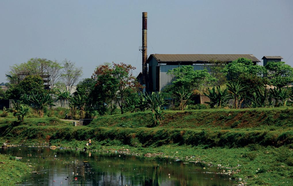
The Citarum River lies on the Island of Java in Indonesia. The river flows 270 km from its source, located south of Badung, to its mouth in the Java Sea, northeast of Jakarta. Water in the river has domestic (related to the home), agricultural, and industrial uses.

1.11: The Citarum River, Indonesia
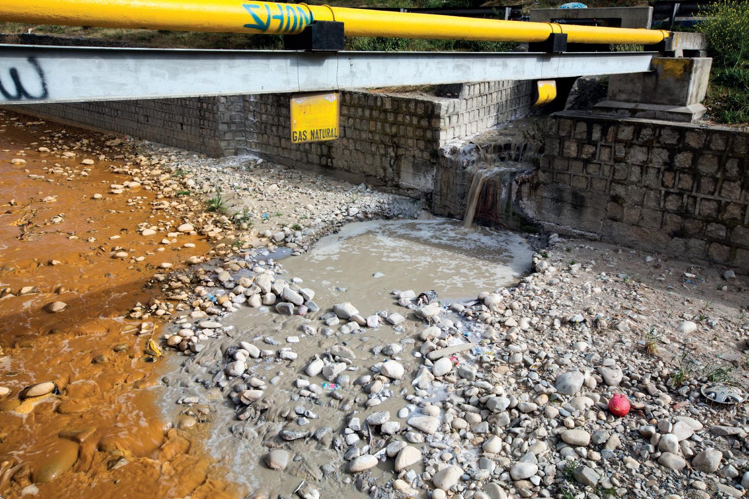
In the 1980s, Indonesia began a period of rapid industrialisation. More than 2,000 factories, making products such as textiles and medicines, were built along the banks of the Citarum River. This was to take advantage of the supply of water. The factories routinely disposed of their waste in the river. Domestic sewage and garbage, such as plastics, entered the river from the towns along its banks. Agricultural runoff from fields also contributed to the decline in water quality.
Source A : Factories dispose of waste in the Citarum River
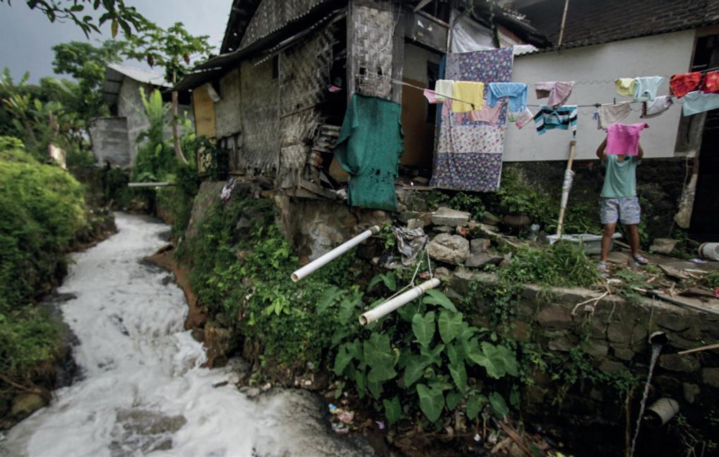
Source B : Domestic waste from homes adds to the pollution of the Citarum
a Identify the source of water pollution that can be seen in each image.
b Explain which source of pollution you think is the worst.
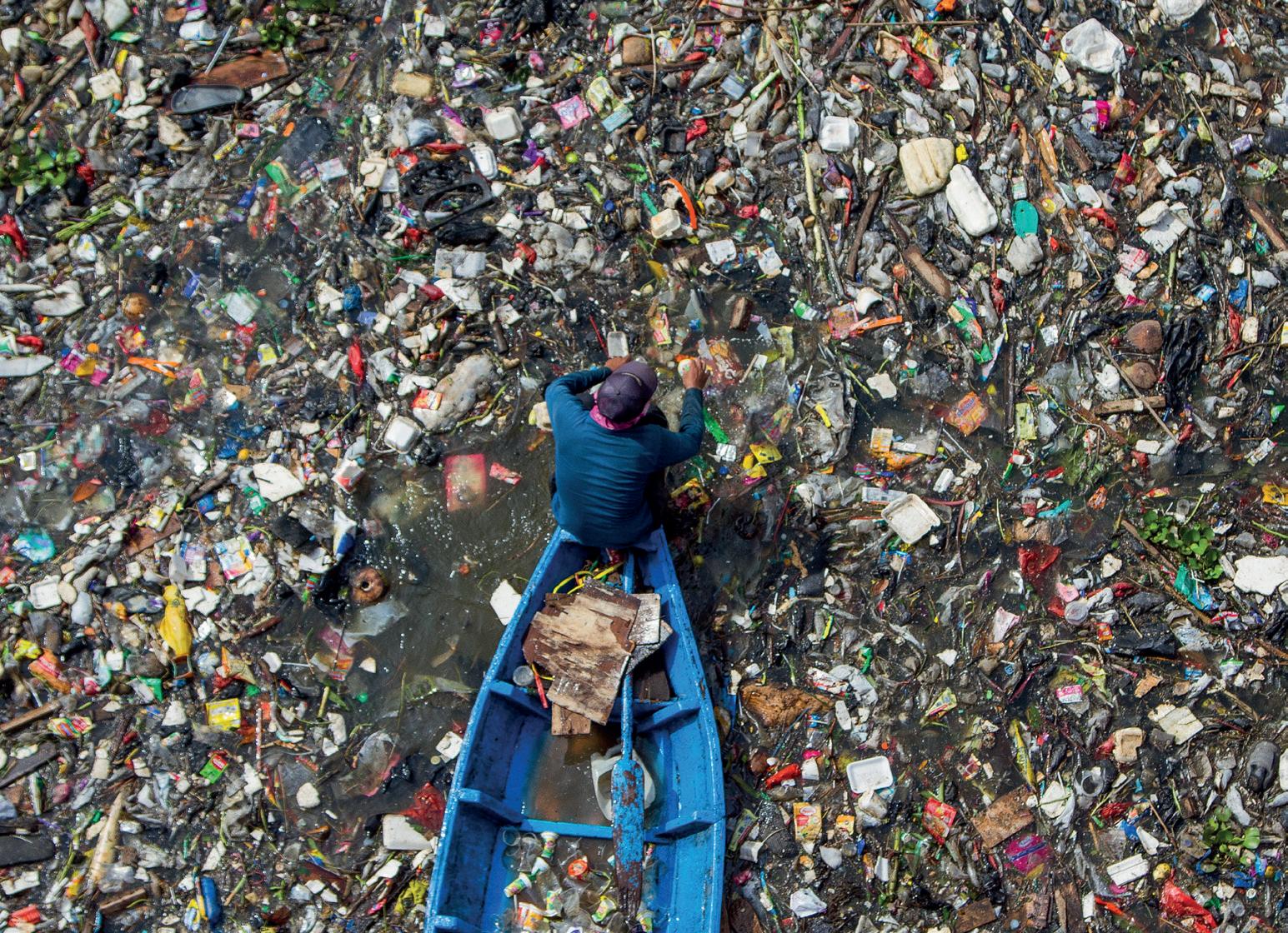
The Citarum is known as one of the most polluted rivers in the world. In some places, the pollution is so bad that it can be difficult to see the water beneath the waste. Solid waste accumulates on the riverbed and clogs waterways, which can increase problems with flooding.
An estimated 9 million people live in close contact with the river, many of whom rely on the water for drinking, cooking, and washing. The water has high levels of bacteria from sewage, which cause illnesses such as cholera. It also contains heavy metals such as lead, aluminium, iron, and manganese, which can damage major bodily organs, such as the liver, kidneys, and heart. When used for irrigation, the water contaminates farmland.
Agricultural runoff, which is high in nutrients, leads to algae blooms and uncontrolled water hyacinth growth. These block sunlight and deplete oxygen levels in the water, making it difficult for aquatic life, such as fish, to survive. This threatens the livelihoods of communities that rely on fishing, and fish that are caught are contaminated with heavy metals and microplastics. Since 2008, the number of fish species in the Citarum has decreased by 60%.
Industrialisation: when a country or area builds factories and begins to manufacture products.
Domestic: related to water use in the home, for example drinking, cooking, and cleaning.
Sewage: human wastewater.
Cholera: a diarrhoeal illness caused by eating food or drinking water contaminated with cholera bacteria.
How does seeing photos like Source C help you to better understand the impacts of pollution on rivers? Which other topics related to rivers could you explore through real life photographs to improve your understanding?
Suggest the impacts of plastic in rivers.
Efforts have been made to restore the Citarum River and its surrounding ecosystems. From 2018 to 2025, the Indonesian government established the Citarum Harum strategy with the goal of making the Citarum’s water drinkable. In February 2023, the United Nations Development Programme (UNDP) carried out training for 40 companies operating along the river, to support the recognition and respect for access to clean water as a human right.
Many of the new techniques that have been introduced are sustainable, in that they balance environmental, social, and economic needs both now and in the future. They include:
• The introduction and enforcement of strict environmental laws. Authorities regularly monitor the river and issue fines to companies and individuals who continue to pollute the river.
• The creation of wastewater treatment and refuse facilities to prevent new contaminants from entering the river.
• The education of local communities about the dangers of pollution and the importance of preserving the river. Alongside Indonesia’s military, locals have also been involved in clean-up efforts. Several communities now regularly collect and sell plastic waste for recycling. Community-led solutions empower local people to take control of their own health and well-being.
• A drive to encourage farmers to reduce their use of harmful chemicals. Buffer zones with native vegetation have been created, which filter pollutants from agricultural runoff.
• A more collaborative approach to reducing the problem of pollution. Government agencies and industries are beginning to work together to solve the problems of pollution.
• Research by Monash University and Universitas Indonesia to develop ways to detect and respond to pollution incidents. Designs include solutions to capture and treat wastewater and solid waste in villages along the Citarum.

Animal & agriculture waste management facility
Houses (with new toilets) connected to smart septic tank and wetlands
Solid waste trap
Animal & agriculture waste management facility Communal
TASK 3: Study Source D
a Identify which aspects of the design target:
i Agricultural pollution
ii Domestic pollution
b The design in Source D does not feature measures to deal with industrial pollution. Suggest how industrial pollution could be targeted.
c Compare these facilities with any that you are aware of in your country.
The sustainable management of the Citarum River is a complex and ongoing task, involving rules, infrastructure development, community involvement, and cooperation. While significant challenges remain, positive steps are being made to restore this vital waterway and to safeguard the wellbeing of the people and habitats that depend on it.
Using what you’ve learned about sustainable river management, work in groups to organise a one‑day clean‑up of a section of the Citarum River. You must include:
• a letter to locals, explaining why the task is necessary
• a risk assessment about the dangers that volunteers might face
• an equipment list, which includes tools to carry out the job, protective clothing and equipment
• a plan for how you will dispose of the collected waste safely
• a poster explaining why it is important to keep the area clean once your team have left.

For a named river you have studied, explain the causes of pollution.
The pollution of the Citarum River is mainly caused by human activity. 1 Firstly, industrialisation along the riverbanks contributes significantly to pollution.
2 In the 1980s, more than 2,000 factories were built along the banks of the Citarum River. 3 Factories release untreated wastewater directly into the river, degrading water quality and harming aquatic life. 4
Extensive urbanisation in the surrounding area and farming practices also play a crucial role. 5 Furthermore, dumping of solid waste, including plastics and household trash, directly into the river adds to the pollution burden. 6
The pollution of the Citarum River in Indonesia could be resolved by introducing laws and building wastewater treatment plants. 7

1 The introductory sentence is strong because it sets the scene. Firstly, the question asks for a named example. The answer states an example, ‘the Citarum River’, although it could be clearer by locating the Citarum River. Secondly, it gives an overview of the causes of pollution, which the answer then goes on to discuss in more detail.
2 It is important to include key words. This answer does this well, as it uses words such as ‘industrialisation’ and ‘urbanisation’. The answer also mentions farming – are there any other key terms that could be used instead of ‘farming’?
3 The question has asked for place-specific references. The use of statistics, such as the number of factories along the Citarum, therefore makes this a stronger answer.
4 This part of the answer could be improved by adding specific information to give more depth to the explanation. For example, the untreated wastewater from the factories contains toxic chemicals, heavy metals, and industrial byproducts.
Now, write an improved response to this answer using the guidance above.
5 This bit of the answer reads like a list. Stronger answers will include developed statements, which means that more explanation is needed here. For example, urbanisation can cause pollution through sewage and domestic waste such as plastics. Pesticides, fertilisers, and sediment from agricultural runoff lead to algae blooms and uncontrolled water hyacinth growth, which block sunlight and deplete oxygen levels.
6 It is good to give examples as this increases the depth of the answer. Here, the answer gives examples of solid waste.
7 Although the final sentence includes accurate and good case study information, it does not answer the question. A better conclusion might be one that summarises the main causes of pollution.
We are working towards endorsement of this title for the Cambridge Pathway.
After studying this topic, think about how confident you are with the different topics. This will help you to find any gaps in your knowledge and learn more effectively.
I can: Needs more work Almost there Ready to move on
understand the key characteristics of rivers and the underlying processes at work in drainage basins
understand the processes involved in erosion, transportation, and deposition in the context of river systems
describe and explain the formation of various river landforms found in the upper, middle, and lower sections of rivers
explore the advantages and risks associated with living near river environments
investigate and explain how regions with issues such as flooding and pollution have implemented sustainable strategies to address these challenges.


Introduction
About the authors
How to use this series
How to use this Teacher’s Resource
About the syllabus
About the assessment
Approaches to learning and teaching
An enquiry-based approach to geography
Teaching notes
Geographical Skills
Theme 1: Physical Geography Topic
Topic
Theme
Topic
Topic
Topic
Geographical Investigations – teacher guidance
Digital resources
The following items are available on Cambridge GO. For more information on how to access and use your digital resource, please see inside front cover.
Syllabus content correlations
Lesson plan template
Detailed specific example revision template and exemplar
Active learning
Assessment for Learning
Developing students’ language skills
Differentiation
Improving learning through questioning
Language awareness
Metacognition
Skills for Life
Coursebook answers
Worksheets
Worksheet answers
Skills worksheets
Skills worksheet answers
End of topic tests
End of topic tests answers
Acknowledgements
CAMBRIDGE
TopicApproximate
1.1 Rivers and drainage basins 2
Understand the key characteristics of rivers and the underlying processes at work in drainage basins.
1.2 River processes 3
Understand the processes involved in erosion, transportation, and deposition in the context of river systems.
Coursebook
Tasks 1– 5
Teacher’s resource
Starter idea 1
Main teaching idea 1
Plenary idea 1
Worksheet 1.1
Coursebook
Tasks 1– 5
Teacher’s resource
Starter idea 1
Main teaching ideas 1– 2
Plenary idea 1
Worksheets 1.2 –1.4
1.3 River landforms 3
1.4 Hazards, opportunities and management 3
Describe and explain the formation of various river landforms found in the upper, middle, and lower sections of rivers.
Coursebook
Tasks 1– 5
Teacher’s resource
Starter idea 1
Main teaching idea 1
Plenary idea 1
Worksheet 1.5
Explore the advantages and risks associated with living near river environments.
Investigate and explain how regions with issues such as flooding and pollution have implemented sustainable strategies to address these challenges.
Coursebook
Tasks 1– 4
Think like a geographer
Teacher’s resource
Starter idea 1
Main teaching idea 1
Plenary idea 1
Homework idea 1
1.5 Detailed Specific Example: The Mississippi River, USA 1
Understand a detailed specific example of a river and the causes and impacts of flooding, and strategies to manage flooding.
Coursebook
1.6 Detailed Specific Example: The Mississippi River, USA 1
Understand a detailed specific example of a river and the causes and impacts of pollution, and strategies to manage pollution
• This topic introduces the hydrological cycle, river processes, river formations and the effects of rivers on human populations and their management. Students may have previously been exposed to the hydrological cycle on a fundamental scale, in Biology or early-stage Geography education. Most will not have the in-depth knowledge outlined in the topic.
• Students may know the basic hydrological cycle (evaporation, condensation, and precipitation), but may not know the rest of the processes (transpiration, evapotranspiration, etc.).
Tasks 1– 4
Project
Teacher’s resource
Main teaching idea 1
Main teaching idea 2
Worksheet 1.6
Coursebook
Tasks 1– 4
Improve this answer
Teacher’s resource
Main teaching idea 3
• Students will likely only have superficial knowledge of river processes and formations. Many will know what waterfalls, meanders and deltas are (for example) but will not know how and why they occur.
• It is unlikely that students will know how a river changes throughout its course but might know that rivers start upstream at ‘the source’ and end downstream at ‘the mouth’.
• You should be prepared to name and explain each process in the hydrological cycle, river processes and river formations. Terminology is a key focus of study, thus prior to teaching the topic, you should revise all key terms to ensure confidence in teaching about rivers.
• This topic has key ter minology that may be new to some students. The ter minology is science-based, and students should be encouraged to use the correct ter ms when answering questions.
• Students need to be able to contrast the processes of erosion and transportation, describing them both as a whole and describing the types of erosion and transportation.
• ‘Solution’ is a type of both erosion and transportation. You need to clearly contrast the two. W ith erosion, solution means that acids in the water break down certain rock types. It is the actual act of ‘breaking down’ the rocks. For transportation, solution refers to minerals and sediment that have been dissolved and are being carried by the river It is an act of transport, and the river is able to move these dissolved particles due to their light weight.
• Use these association words to help explain the processes of river erosion:
• Abrasion = abrasive: particles hit the riverbank and abrasively wear it away, like sandpaper abrading wood
• Attrition = friction: when particles hit against each other, friction is created which breaks them into smaller pieces
• Suspension = suspenders (to hold in place): very fine sediment is held up by a river, similar to how suspenders hold up trousers
• Solution = dissolve: sediment is dissolved by the river like how the contents of a bag of tea dissolve when it comes into contact with water
• Using visual aids like diagrams or videos may assist students in grasping certain topics more easily. For example, using a diagram with arrows of the hydrological cycle to show the movement of water throughout, or using animated videos to showcase river erosion methods.
• Use sentence starters to help students structure their answers correctly. For example: ‘Flooding occurs due to’, ’River areas pose opportunities and hazards to the environment and people, such as’, ‘Erosion in rivers occur due to four main processes, namely’, ‘River meanders are formed due to’.
LEARNING
Characteristics of rivers and drainage basins: the long profile, width, depth, speed of flow/velocity, discharge, wetted perimeter, channel, watershed, tributary, confluence, source, and mouth.
The Bradshaw model.
How the drainage basin operates within the water cycle.
By the end of this topic you’ll be able to:
•Understand the key characteristics of rivers and the underlying processes at work in drainage basins.
Students can:
• Discuss how each process of the hydrological cycle impacts how much water is returned to the oceans.
• Understand the processes which operate within a drainage basin
• Explain how rivers differ upstream and downstream, using the Bradshaw model.
Processes which operate in a drainage basin: precipitation, interception, infiltration, percolation, overland flow, channel flow, throughflow, groundwater flow, transpiration, evaporation, and evapotranspiration.
Misconception
The water cycle only includes evaporation, condensation, and precipitation.
How to identify
Ask students to draw the water cycle. They are likely to only include evaporation, condensation. and precipitation. Students generally exclude interception, infiltration, percolation, throughflow, groundwater flow, transpiration, evapotranspiration, overland flow. and channel flow.
Precipitation includes only rain. Ask students what precipitation is. Many are likely to say ‘rain’ and exclude hail, sleet and snow.
Average river velocity is fastest at the source.
Rivers are fastest at the mouth, where they are the largest.
Students often think that the average velocity is fastest upstream due to the force of gravity.
How to overcome
Explain the hydrological cycle using diagrams with annotated labels. Have students make their own diagram. Emphasis should be placed on the cyclical movement of water throughout the hydrological process. i.e., how water can change states throughout the process but eventually end up back in take over of water.
Write a short definition of precipitation.
By use of the Bradshaw Model, explain why river velocity is slower upstream than downstream:
• Average velocity increases downstream due to additional water from tributaries
• Less water is in contact with the beds and bank downstream. This reduces friction, allowing water to move faster.
Students may think that river velocity is fastest at the mouth after learning that it is slower at the source.
Explain how and why rivers lose energy close to the mouth of a river.
1 The hydrological cycle and drainage basins (10 mins)
Resources:
• Unlabelled diagrams of the hydrological cycle and a drainage basin
• Pens
Description and purpose: This exercise will help gauge students’ prior knowledge of the hydrological cycle, especially because some students will only know the processes of evaporation, condensation, and precipitation. This task will also help students get a visual representation of a drainage basin, from source to mouth.
Hand out unlabelled diagrams of the hydrological cycle and ask students to label each process presented. Students can also add arrows to show the cyclical movement of water (you should have your own copy to aid students in marking). Refer to Source A in Topic 1.1 of the Coursebook for guidance.
Hand out unlabelled diagrams of the drainage basin and ask students to label the different parts, including: source, tributary, drainage basin, main river channel, mouth, and confluence. Refer to Source E in Topic 1.1 of the Coursebook for guidance.
What to do next: Go through the labelled diagrams as a class and identify any mistakes and/or missing labels.
1 Understanding the hydrological cycle (30 mins)
Learning intention: Understand the processes of the hydrological cycle and the movement of water through it.
Resources:
• Coursebook, Topic 1.1
• Source A
• Task 1
• Pens, pencils, and paper
• Worksheet 1.1, ‘Key terms: Definition’
Description and purpose: This task assists students in understanding and identifying the different processes of the hydrological cycle. It will help expand their knowledge by showcasing the various processes, prior to which they may only have thought of as evaporation, condensation, and precipitation.
Ask students to complete Worksheet 1.1. They should fill in all the processes, which are listed in the Coursebook, with their definitions. Give students five minutes to revise their table, and in that time, you can write the different processes on your board. After five minutes, randomly select a student for each process and have them write the correct definition for their respective process.
Differentiation ideas:
• Support: Divide the class into groups of mixed ability, and have each group make an A3 poster depicting the hydrological cycle (with all processes included). You should ensure that each student in each group contributes to the poster, so designating a specific process to each student will ensure fairness. You can either provide an unlabelled template of the hydrological cycle, or have students make one from scratch. You can also ask students to provide definitions of each process to see their level of understanding. If students are not successful in this task, you should revisit the hydrological cycle as it is a key component to the rest of the chapter.
• Challenge: You could ask confident students to research how the topography of different places affects the hydrological cycle. The cycle will differ spatially as some areas have more/less vegetation (interception, transpiration), more permeable/impermeable soils, and rocks (infiltration), more/less rivers to drain into (overland flow), etc.
Assessment ideas: Ask students to write a short paragraph which provides a definition about each process of the hydrological cycle (100 –150 words in total). Encourage students to follow a pattern with their paragraph – for example, defining evaporation, condensation, and precipitation first, then all processes that happen before water reaches the ground (interception, transpiration, evapotranspiration), then the movement of water on and through the ground.
1 The answer is XYZ (15 mins)
Resources:
• Pre-made list of answers
• Pens
Description and purpose: This plenary tests students’ ability to think critically. Provide students with 10 answers, to which they must write the question. This can be done as a group activity, or individually. The questions they formulate should start with ‘what is’, ‘name the’, ‘define’, or ‘describe’. You could also give students definitions and ask them to put the correct terminology in the question.
For example:
• Answer (provided by you): Precipitation, interception, evaporation, percolation, condensation, infiltration, overland flow
• Question (formulated by students): Name seven processes in the hydrological cycle.
• Answer (provided by you): The edge of a drainage basin, usually on higher ground.
• Question (formulated by students): What is a watershed?
LEARNING PLAN
Learning objectives
Processes which operate within a river:
• erosion: hydraulic action, abrasion, attrition, solution
• transportation: traction, suspension, saltation, solution
• deposition.
Learning intentions
By the end of this topic you’ll be able to:
• Understand the processes involved in erosion, transportation, and deposition in the context of river systems.
Success criteria
Students can:
• Identify, define, and explain each type of erosion and transportation
• Explain the factors that can influence the rate of erosion
• Identify where each process of erosion and transportation is likely to take place
• Explain the reasons for deposition and where it mostly takes place.
Misconception
Rivers are solely responsible for eroding landscapes.
This topic focuses purely on river erosion, transportation, and deposition, and does not directly account for other processes such as weathering, glacial movement, and other mass movements. Students may be inclined to think that only rivers are responsible for the erosion of landscapes as they work through the topic. Prior to starting, briefly summarise how rivers and other processes can shape landscapes.
Briefly introduce physical, chemical, and biological weathering and mass movements and emphasise that they also play a role in landscape formation. You could show them this video
Clay particles are the smallest particles so they are the easiest to transport.
1 Matching game (10 mins)
Resources:
• Classroom whiteboard
• Markers
• Paper, pencils, and/or pens
Ask students to rate sand, silt, and clay from smallest to largest. Clay is the smallest. Ask them to state which particle they think will be the easiest to transport. Many will then choose clay, as it is the smallest, which may mean to them that it is the lightest.
Explain the cohesive nature of clay to students, and how clay particles clump together and absorb water which makes them heavier. Thus, clay would require a higher water velocity to erode. This becomes important is AS Level Geography as part of the Hjulstroms Curve.
Description and purpose: This exercise will help gauge students’ prior knowledge of river transportation and erosion processes. It will expose them to the new terminology that is to come in Topic 1.2.
Before your lesson, write down all the processes of river transportation (traction, saltation, suspension, solution) and erosion (abrasion, attrition, hydraulic action, and corrosion/solution) in random order on the whiteboard. Then, make a two-column table on the board with the headings ‘River transportation processes’, and ‘River erosion processes’.
Once you start your lesson, tell students they need to match the processes to the correct column, and give you a verbal reason why they think each one belongs to each column. You can allow students to fill in the answers on the board.
What to do next: It is unlikely that students will get all the processes correct in their respective column, so when they are done, fix the columns with the correct processes. Then, ask students to copy the table from the whiteboard so they have a short summary on the topic’s content.
1 Understanding river processes (40 mins)
Learning intention: Understand the processes involved in erosion, transportation, and deposition in the context of river systems.
Resources:
• Coursebook, Topic 1.2
• Tasks 1–3
• Pens and pencils
• Three pieces of paper
• Worksheets 1.2 and 1.3, ‘River processes’ and ‘Fill in the missing words’
• Video about erosion processes
• Video about transportation processes
Description and purpose: First, ask students to complete Tasks 1–3 from the Coursebook. These tasks assist students in understanding and identifying the different processes that fall under river erosion, transportation and deposition, and where these occur.
Then, ask students to complete Worksheet 1.2. The worksheet includes three tables – one for erosion, one for transportation, and one for deposition. In each table, students should add the definition, where it occurs in a river, and a diagram for each type of erosion and transportation process (note that the table for deposition looks different because it does not have sub-processes). You can make use of the videos linked in the ‘Resources’ section to help your teaching.
Differentiation ideas:
• Support: For erosion and transportation, it is helpful to look at each process separately and then put it all together so that students can see how the processes change as you move downstream. If students have internet access, divide them into groups and split assign a process to each group. Note if students are confusing similar words like ‘abrasion’ and ‘attrition’, or ‘suspension’ and ‘solution’. If this is an issue, follow the word association advice in the ‘Language support’ feature.
• Challenge: Ask students to find real-world examples of each process. For example, for ‘hydraulic action’, students could find photos where fast flowing water is hitting the banks of a river. Students can compare images and discuss as a group.
Assessment ideas: To test students’ understanding of river processes, ask them to complete Worksheet 1.3. They should fill in the missing words.
2 River valleys and the cross and long profiles (30 mins)
Learning intention: Understand how the shape of a river changes as from the upper course to the lower course.
Resources:
• Coursebook, Topic 1.2
• Figure 1.5
• Task 5
• Pens and paper
• Internet access
• Worksheet 1.4, ‘Spider diagrams’
• Video about long and cross profiles
Description and purpose: This task will help students to identify a river’s long profile and cross profile from source to mouth.
Ask students to complete Worksheet 1.4. Students will make a spider diagram with three ‘branches’, one for each course (lower, middle, upper). At each branch, students will draw the long and cross section of each course and write a bullet point list of the main characteristics.
Answers: Use the information in the Coursebook, Topic 1.2 under ‘River valleys and the long and cross profiles’ as a guideline to construct the mind map.
CAMBRIDGE IGCSETM AND O LEVEL GEOGRAPHY: TEACHER’S RESOURCE
Differentiation ideas:
• Support: Show students the video linked in the ‘Resources’ section, showing the long and cross profiles.
• Challenge: Get students to start thinking about what landforms are most likely to be in each course –they can carry out research.
Assessment ideas: Ask students to complete Task 5 in the Coursebook, where they will draw a cross section based on a data table and answer questions about the cross profile.
1 Heads up: river processes (15 mins)
Resources:
• Sticky notes/small pieces of paper
• Pens Description and purpose: This game is a fun and interactive way of consolidating students’ knowledge about river processes.
Write down a river process/terminology and place the piece of paper on a student’s head. This student is the only one who cannot see what the paper says. The student then asks the rest of the class ‘yes’ or ‘no’ questions to help them figure out what the answer is. Once the student has given the correct answer, move on to the next person.
Possible words to use:
• Lateral erosion
• Hydraulic action
• Attrition
• Abrasion
• Solution
• Traction
• Saltation
LEARNING PLAN
The characteristics and formation of landforms: waterfalls, rapids, gorges, V-shaped valleys, meanders, oxbow lakes, levees, flood plains, deltas, interlocking spurs, and potholes.
• Suspension
• Elevation
• V-shaped valleys
• Kinetic energy
• Floodplain
• Long profile
• Cross profile
By the end of this topic you’ll be able to:
• Describe and explain the formation of various river landforms found in the upper, middle, and lower sections of rivers.
Students can:
• Describe, identify, and explain each river landform.
Misconception
All rivers have all the landforms outlined in the coursebook.
How to identify
When going through this topic in the coursebook, students might be under the impression that all rivers have all the landforms mentioned.
1 Identify the river landform (10 mins)
Resources:
• Images of river landfor ms
• Whiteboard and projector/smartboard
How to overcome
Explain that all rivers are unique, and some may not have deltas, waterfalls, meanders, etc. Ask students to research rivers that have some of these landforms and rivers without some of these landforms.
Description and purpose: This activity introduces river landforms visually to students and will help you gauge if they have any prior knowledge on different types of river landforms.
In no particular order, display images of river landforms to students (waterfalls, meanders, oxbow lakes, gorges, V-shaped valleys, interlocking spurs, deltas, floodplains, rapids, potholes, levees). Allow students to identify each landform and only correct them at the end once all images have been showed. What to do next: Provide students with a print-out of all the images you showed with their correct names. You can also challenge students to describe the formation of a landform, if you find the students correctly identified many of them correctly.
1 River landforms (45 mins)
Learning intention: Describe and explain the formation of various river landforms found in the upper, middle, and lower sections of rivers.
Resources:
• Coursebook, Topic 1.3
• Tasks 1– 4
• Pens and paper
• Internet access
• Video about how a waterfall is formed
• Video about how meanders and oxbow lakes are formed
• Video about how deltas are formed
Description and purpose: This task will facilitate students’ in explaining the formation of rapids, waterfalls, gorges, meanders, oxbow lakes, levees, floodplains, and deltas.
Ask students to write a paragraph (150 –200 words) which describes at least two river formations, where they are found (upper-, middle-, or lower-course and why), and how they are formed. Encourage students to choose two landforms that relate closely to each other (for example, meanders and oxbow lakes, or floodplains and levees, or waterfalls and gorges).
Answers: Use the example below as a guideline to assessing the paragraphs: Rapids typically occur in the upper course of a river where the water is shallow and the gradient is steep. Rapids can form when flowing water encounters obstacles like boulders and rock, or alternating bands of hard and soft rock. These obstacles disrupt the flow of water which creates turbulence, known as whitewater. Waterfalls occur when a river flows over bands of hard and soft rock. The rock undergoes erosion (hydraulic action and abrasion), in which the softer rock will erode first because it is less resistant. This creates a drop in the level of the land below the river. Once a waterfall is well established, the force of the water plunging over the ledge can undercut the hard rock. Eventually, the hard rock becomes too unstable and will fall into the plunge pool. This cyclical process of erosion and undercutting can create ‘retreat’; the backward movement of water upstream. This creates a narrow valley, called a ‘gorge’.
Differentiation ideas:
• Support: Use the videos in the ‘Resources’ section to visually explain the formation of different landforms. Some students might not grasp the concept of ‘waterfall retreat’ (waterfalls), ‘centrifugal forces’ (meanders), or ‘distributaries’ (deltas), and a video may support this.
• Support: Some students may find paragraph writing intimidating, so provide them with sentence starters to help them. For example, ‘Waterfalls generally occur [in the upper courses] due to [consistent erosion of bands of hard and soft rock].’ or ‘Depositional features generally occur in the lower courses due to the river losing energy, for example [floodplains and levees]’.
• Challenge: Ask students to find named examples of river formations and add them to their paragraphs. If you are teaching in a diverse school, ask students to find examples from their own country, where applicable.
Assessment ideas: To test their understanding of river landforms, ask students to draw the processes of the formation of waterfalls, meanders, oxbow lakes, etc., without using their books. They can refer to the paragraphs they have written to help them.
1 Quiz on river landforms (15 mins)
Resources:
• Worksheet 1.5, ‘River landforms quiz’
• Pens
Description and purpose: Worksheet 1.5 is a quiz which will help solidify students’ understanding of river landforms.
The quiz covers each landform and is quick to do. Students should do the quiz independently and you should mark the quizzes and return them to students with corrections where necessary.
2 Flash cards on river formations (5 mins for each)
Resources:
• A list of all river formations (rapids, waterfalls, gorges, meanders, oxbow lakes, floodplains, levees, deltas)
• Coursebook, Topic 1.3
• Pens and card paper
Description and purpose: This activity will help students when they are studying, as well as guiding them to write about landforms.
After teaching each formation, ask students to write a short summary on a small piece of paper as a flashcard. The summary should include the name of the formation; a short definition of the formation; why the formation occurs; and, where it is likely to occur. Students can also include examples and simplified drawings.
USA; The Citarum River, Indonesia
LEARNING PLAN
The opportunities and hazards of living near a river.
The human and natural causes of river flooding.
The impacts of river flooding.
An evaluation of the strategies and techniques used to manage river pollution; including sustainable management techniques.
By the end of this topic you’ll be able to:
• Explore the advantages and risks associated with living near river environments.
•Investigate and explain how regions with issues such as flooding and pollution have implemented sustainable strategies to address these challenges.
Students can:
•Identify and explain the advantages and disadvantages of living near a river
•Explain the physical and human causes of flooding and pollution.
• Explain the environmental, social, and economic impacts of floods.
• Compare different hard and soft engineering techniques.
One detailed specific example, to include:
•the causes and impacts of a flood for a named river
•the strategies and techniques used to manage the flooding of the river; including sustainable.
One detailed specific example, to include:
•the causes and impacts of pollution in a named river
•the strategies and techniques used to manage pollution levels in the river; including sustainable.
•Understand a detailed specific example of a river and the causes and impacts of flooding, and strategies to manage flooding.
•Understand a detailed specific example of a river and the causes and impacts of pollution, and strategies to manage pollution.
•Understand a detailed specific example of a river and the causes and impacts of flooding.
•Evaluate strategies to manage flooding for a detailed specific example.
•Understand a detailed specific example of a river and the causes and impacts of pollution.
•Evaluate strategies to manage pollution for a detailed specific example.
Misconception
How to identify
Floods only occur during winter.Ask students ’In which season does it flood?’. Most are likely to answer ‘winter’ as it is associated with colder weather and rainfall.
Living on higher ground protects you from floods.
Ask students if high elevation areas can flood. Many may say no, due to large river channels and lack of floodplains.
1 Spider diagrams (10 mins each)
Resources:
• Three pieces of paper
• Pens
How to overcome
Floods can occur in any season. Provide students with examples where flooding has occurred in summer, spring, and autumn.
E.g., Coverack, Cornwall, UK floods in July 2017.
Inform students that while it is unlikely for an area on high elevation to flood, it is still possible, especially if there is a significant amount of surface run-off, high groundwater levels and poor flood resistant infrastructure (blocked sewage pipe or burst pipes, etc).
Description and purpose: This activity will help gauge students’ knowledge about the hazards and opportunities associated with rivers, as well as the ways humans manage rivers. As students add to their diagrams throughout the lesson, they will help consolidate students’ knowledge and ability to compare and contrast different ideas.
Ask students to create three spider diagrams on three separate sheets of paper. One spider diagram will represent ‘Opportunities and hazards of rivers’, one will represent ‘Human and physical causes of flooding’, and one will represent ‘Hard and soft engineering techniques’. They should write down everything they know about each topic. Students can work together and discuss the different topics or they can work independently. You can help students think more critically by providing prompts, such as:
• Opportunities and hazards of rivers: Is it safe to live in an area prone to floods? Are there any advantages to it? Can flooding be good and bad?
• Human and physical causes of flooding: What is flooding, and why does it happen? Is it purely a result of nature or do human activities play a role?
• Hard and soft engineering techniques: How has your town or city responded to floods or heavy rainfall? Have you seen anything that helped the water move through the area without causing too much harm? What to do next: Teach Topic 1.4 in the Coursebook, and then move onto the Teacher’s Resource Main Teaching Idea 1. Here, students complete their spider diagrams with their newly acquired knowledge.
1 Extended writing on DSE 1: Sustainable management of river flooding (35 mins)
Learning intention: Facilitate students in learning to write longer answers.
Resources:
• Coursebook, Topic 1.5
• Task 2
• Pens and paper
• Spider diagrams from Starter Idea 1
• Worksheet 1.6, ‘Extended writing practice’
Description and purpose: This activity will help students learn to write formally, and with the correct format (introduction, body, conclusion). The short essay writing aspect of this task should take roughly 15 minutes (plus 5 minutes for planning) and the discussion should take about 15 minutes. Make use of Worksheet 1.6 and print it out for students to help guide them.
Ask students to choose one of the following questions, which are applicable to the DSE:
1 Describe the causes and effects of flooding in the Mississippi River.
2 Describe the strategies used to manage flooding in the Mississippi River.
Before students start writing, they should plan their answer (5 minutes). They can use the spider diagrams from Starter Idea 1 and complete any missing information to help them in their planning. Here, you should guide them in what information to reference, respective to their chosen question. Their answers should be 200–300 words. Task 2 in the Coursebook will help students think of more ideas and how opportunities and hazards may change over time and change spatially.
Differentiation ideas:
• Support: ESL students may struggle to write longer answers, so you should provide guidance on what information goes in the introduction, body and conclusion. You can guide students by reviewing their introduction before they move onto the body of the answer, and reviewing their answer body before they move onto their conclusion.
• Challenge: Allow confident students to help the less confident by comparing their plans
Assessment ideas: Allow students to assess each other’s answers by giving them criteria (relevance, accurate data used, evaluating statement correctly, i.e. talking about both causes and effects, etc.) to assess each other on. They can discuss if certain answers need more (or less) information or if some information is irrelevant.
2 DSE: The Mississippi River, USA video (20 mins)
Learning intention: Understand a detailed specific example of a river and the causes and impacts of flooding, and strategies to manage flooding.
Resources:
• Coursebook, Topic 1.5
• Video: The Mississippi River, USA
Description and purpose: This task engages students with the detailed specific example that investigates flooding of The Mississippi River, USA.
First, teach students Topics 1.1–1.4, then use the DSE to show students how the information can be applied to a specific example. Use the video listed in ‘Resources’ to introduce the DSE of The Mississippi River, USA. Play the video all the way through. Encourage students to watch carefully and make notes for the following questions:
1 Where is the Mississippi River?
2 What are the causes of flooding along the Mississippi River?
3 How are the problems of flooding along the Mississippi River managed? Following the clip, ask students to discuss the questions in pairs and then compare answers as a class.
3 DSE: The Citarum River, Indonesia video (20 mins)
Learning intention: Understand a detailed specific example of a river and the causes and impacts of pollution, and strategies to manage pollution.
Resources:
• Coursebook, Topic 1.6
• Video: The Citarum River, Indonesia
Description and purpose: This task engages students with the detailed specific example that investigates pollution in The Citarum River, Indonesia.
First, teach students Topics 1.1–1.4, then use the DSE to show students how the information can be applied to a specific example. Use the video listed in ‘Resources’ to introduce the DSE of The Citarum River, Indonesia. Play the video all the way through. Encourage students to watch carefully and make notes for the following questions:
1 Where is the Citarum River?
2 What are the causes of pollution along the Citarum River?
3 What are the effects of pollution along the Citarum River?
4 How is the Citarum River being managed in a sustainable way?
Following the clip, ask students to discuss the questions in pairs and then compare answers as a class.
1 Quiz on river landforms (15 mins)
Resources:
• Coursebook, Topics 1.4 and 1.6.
• Pens, paper
Description and purpose: This activity is interactive and allows students to explore different questions relating to the hazards and opportunities of rivers, as well as the two DSEs.
Ask each student to write an exam or test style question (ranging between 3 –7 marks) and mark scheme. Then, the students should swap questions with another, and answer each other’s questions. Then, each student needs to mark the others’ answer based on the mark scheme.
At the end, the students should reflect on the quality of their questions and mark schemes. You should provide guidance to the students here on the type of questions they should ask, and that they should include command words.
Examples:
‘State and explain three opportunities of rivers’.
‘Explain why rivers can be a hazardous environment’.
‘With reference to an example, how has an area adapted to river floods?’.
When students start the project, they should use internet sources that allow them to research successful flood-resistant infrastructure. Give them key words or prompts (see below) to help them begin their research. Students should look at real-life examples, which they can find by searching for case studies relating to floods and flood-resistant infrastructure (Google Scholar is recommended).
Key words/prompts: ‘soft-engineering for floods’, ‘hard-engineering for floods’, ‘floodresistant architecture/infrastructure’, ‘how to make buildings resilient to floods’, ‘gabions’, ‘seawalls’, ‘flood revetments’, ‘rock armour’, ‘how vegetation reduces the impacts of floods’, ‘diversion spillways’, ‘sandbags for floods’, and ‘sustainable flood protection infrastructure’.
Each pair/group should assess at least three infrastructural ideas and give them ratings out of five based on:
• Durability/resistance to floods
• Cost/affordability
• Accessibility to LICs, MICs, and HICs
• Sustainability
Their pitches could follow this layout:
1 Initial ideas/research summary
2 Ratings of those ideas
3 How they used their research to develop their own flood-resistant infrastructure (follow the ‘What’, ‘Why’, ‘How’ method), including sketches/images
4 The name of their design
5 Their ratings of their infrastructure
6 A closing statement.
At the end of each pair/group’s pitch, allow the rest of the class to ask them questions if they have any.
Criteria
Organisation and clarity (Infrastructure idea and responses are outlined in a clear and orderly way)
Design of their proposed infrastructure (look at the uniqueness, how they incorporated real-life examples, how appropriate it is to the project question)
Accuracy of their research (correct definitions and ratings of examples)
Teamwork
Completely clear and orderly presentation
You can assess each pair/group using the following rubric, which you should share with them before they start their projects:
Mostly clear and orderly in all parts
Clear in some parts but not overall
Unclear and disorganised throughout
Very strong pitch about their design given throughout
Many good points given with only minor problems
Some decent points, but some significant problems
Few or no real points given and significant problems.
Excellent research and accurate ratings of examples
Each student has contributed either in the creation of the pitch (research, design drawings, PowerPoint making) or in the pitch delivery (verbally presenting to the class)
Good research and ratings, with some minor errors
Decent research and ratings, with some significant problems
Poor research and ratings, failing to accurately describe ideas
Most of the group contributed
Less than half of the group contributed
Only one member of the group created the project
1 Compare hard and soft engineering techniques – paragraph writing
For Topic 1.4, ask students to write an answer to the following question: ‘Compare a hard and soft engineering technique of your choice’. The key word here is compare, so ensure students are aware that they need to write in a comparative way outlining the similarities and differences. In their answer, they should write a paragraph (about 150 words) describing each technique, and their advantages and disadvantages.
Researching
Ask students to research a flood event in any country in the world. If students come from flood-prone areas, they can research their own country’s flood event. They should make a list of the human and natural causes of the flood, the impacts of the flood, and any flood management or mitigation techniques that were applied. Then, in class, each student should present their findings.
Topic 1.1:
This video gives an overview of how the hydrological cycle works. This video introduces the drainage basin system and the hydrological cycle.
Topic 1.2:
This short video outlines river erosion processes.
This short video outlines river transportation processes.
This video introduces river valley profiles.
This video explains the journey of a river, from its source to the sea.
Topic 1.3:
This video is about the formation of landforms along the different stages of a river’s course.
This video outlines how a waterfall is formed.
This video outline how meanders and oxbow lakes are formed.
This video explains why rivers have deltas.
Topic 1.4:
This site summarises flood management strategies and is a useful revision tool.
This video discusses the causes and impacts of flooding.
This video outlines river management strategies.
This video explains why the Netherlands is not underwater, and the hard engineering techniques they have used to prevent flooding.
Topic 1.5:
This site explains the back story of the Mississippi River, including its importance in tourism, fishing and recreation, as well as the future of the river.
This short video outlines the size of the Mississippi River’s drainage basin and its importance for navigation and for the natural environment.
Topic 1.6:
This site outlines some of the problems experienced in the Citarum River region, and what the UNDP and EU have done to help reduce pollution in the river.
Language and extended writing worksheets (downloadable)
1 Vocabulary building worksheet
Title: Worksheet 1.1, ‘Key terms: Definition’
Description: This worksheet accompanies Main Teaching Idea 1 in Topic 1.1. It will support students in remembering all key terms in Topic 1.1 and allows them to further expand their understanding by making use of sketches, analogies, and association words that they find helpful.
2 Vocabulary building worksheet
Title: Worksheet 1.3, ‘Fill in the missing words’
Description: This worksheet accompanies Main Teaching Idea 1 in Topic 1.2. It develops students’ knowledge of key terms in Topic 1.2 and helps them learn how to read longer paragraphs.
3 Extended writing worksheet
Title: Worksheet 1.6, ‘Extended writing practice’
Description: This worksheet accompanies Main Teaching Idea 1 in Topic 1.4 –1.6. The document guides students to structure an extended writing answer using examples.
Geographical skills worksheets (downloadable)
1 Summarising worksheet
Title: Worksheet 1.4, ‘Spider diagrams’
Description: Worksheet 1.4 accompanies Main Teaching Idea 2 in Topic 1.3. Students note down the key characteristics of the three river courses in a spider diagram, as well as draw their cross and long profiles, developing their summarising, and sketching skills.
2 Geographical skills worksheet
Title: Worksheet 1.7, ‘Geographical skills’
Description: This Worksheet assists students in their graph plotting and basic mathematical skills.
Other worksheets (downloadable)
1 Vocabulary building worksheet
Title: Worksheet 1.2, ‘River processes’
Description: This worksheet accompanies Main Teaching Idea 1 in Topic 1.2. It strengthens students’ ability in distinguishing between river erosion, transportation and deposition processes, as they list types of processes, their definitions, and supporting sketches.
2 Multiple-choice quiz worksheet
Title: Worksheet 1.5, ‘River landforms quiz’
Description: This worksheet accompanies plenary idea 1 in Topic 1.3. It is a quiz, which covers mainly descriptive questions about river formations and will help students remember key details about river formations.
Downloadable documents
• End-of-topic-test (downloadable)
• Rivers end-of-topic test
• Worksheets (downloadable)
• Worksheet 1.1, ‘Key terms: Definition’
• Worksheet 1.2, ‘River processes’
• Worksheet 1.3, ‘Fill in the missing words’
CAMBRIDGE IGCSETM AND O LEVEL GEOGRAPHY: TEACHER’S RESOURCE
•Worksheet 1.4, ‘Spider diagrams’
•Worksheet 1.5, ‘River landforms quiz’
•Worksheet 1.6, ‘Extended writing practice’
•Worksheet 1.7, ‘Geographical skills’
•Answers: Worksheets, tests
•Worksheet 1.1, ‘Key terms: Definition, answers’
•Worksheet 1.2, ‘River processes, answers’
•Worksheet 1.3, ‘Fill in the missing words, answers’
•Worksheet 1.4, ‘Spider diagrams, answers’
•Worksheet 1.5, ‘River landforms quiz, answers’
•Worksheet 1.6, ‘Extended writing practice, answers’
•Worksheet 1.7, ‘Geographical skills, answers’
•Rivers end-of-topic test, answers