CITY OF MA CHESTER
City of Manchester Plan 1945 This report has been digitised by Joe Blakey and Martin Dodge from the Department of Geography, University of Manchester. The digitisation was supported by the Manchester Statistical Society’s Campion Fund. Permission to digitise and release the report under Creative Commons license was kindly granted by Manchester Libraries, Information and Archives, Manchester City Council. (Email: archiveslocalstudies@manchester.gov.uk)
This work is licensed under a Creative Commons Attribution-NonCommercialNoDerivs 3.0 Unported License. 20 July 2013.
. . . .. ' .. . . .. . ,.
,.
#
r
"
f
~...
I '
(-4
I}
•\(;t't:.S
·{ ..
r~etd
r.
I
•
L' I
_s
..
..
.
.
.. . .
• f'
r
.• . •
,
• f
f'
r
,. ,.
-
,
't
t (
I
.. .
"
r
CITY OF MANCHESTER PLAN
PANORAMA: THE CITY TO-DAY
A. SHERWOOD EDWARDS, CITY ARCHITECT'S DEPT.
CITY OF MANCHESTER PLAN P R EPARED FOR THE CITY COUNCIL By
R . N ICHOLAS,
B.Sc., M.lnst.C.E., M.T.P.I.
City Surveyor and Engineer
PREFACE
BY
ALDERMAN WILLIAM PHILIP JACKSON Lord Mayor of Manchester AND
BY
COUNCILLOR OTTIWELL LODGE Chairman of the Town Planning and Buildings Committee
Printed and published for the Manchester Corporation by
JARROLD
& SONS, LIMITED
NORWICH AND LON DO N 1945
t.
//~£~
/ .-
-
COPYRIGHT
First Printing
PREFACE by the Lord Mayor of Manchester
ALDERMAN W. P. JACKSON, J.P. WHEN THE POST-WAR PLANNlNG of Manchester was begun about two years ago the intention was to present
the proposals to the Town Planning and Buildings Committee, and subsequently to the City CouncH, in a series of reports supported by plans. As the City Surveyor proceeded with his great task it became increasingly evident that the problems of planning and reconstruction in Manchester were so interrelated that it would be wiser and more informative to prepare and present the Plan as a whole. Accordingly, this course was adopted, and in this book Mr. Nicholas has developed his ideas for the future of Manchester. His arguments and suggestions are based on the results of original research and the study of factual data, and he has endeavoured throughout the treatise to illustrate his proposals by a comprehensive series of diagrams, plans and pictures. The Manchester Civic Authorities and indeed all who are concerned in the layout of the city will, it is hoped, be assisted by this publication to appreciate the effect of any planning policy which they may officially adopt. To-day our country is at the beginning of the great transition from war to peace, and all thinking people will wish to inquire about the sort of world to be built for posterity. Among the major questions is that of town and country planning, and most opportunely the City of Manchester Plan appears at this time, making a contribution to planning in general and to the planning of Manchester in particular. The extent to which the Civic Authorities will be able to remodel Manchester as a fairer city with greatly improved living and working conditions will depend ultimately upon the interest, determination and wishes of the citizens, to whom I commend this book for careful study. Lord Mayor's Office, Manchester. May, 1945.
W. P. JACKSON, Lord Mayor.
by the Chairman of the Town Planning and Buildings Committee
COUNCILLOR OTIIWELL LODGE IN AUGUST, 1941, Lord Reith addressed the Manchester and District Regional Planning Committee,
of which Manchester is a constituent authority, and advised the preparation of a provisional plan for redevelopment. He suggested that those responsible should not consider themselves bound by existing legislation, but that they should plan boldly and comprehensively. This was, indeed, a challenge, and an inducement to tackle the multifarious problems which beset us on all sides according to modern conceptions of planning. Mr. Nicholas has approached each problem with no preconceived ideas and no prejudices. He has examined with great thoroughness all available information, and where this was not sufficient he has made his own investigations. Yet it has been ever present in his mind that the health and happiness of our citizens must be his ultimate concern. Here is no attempt to revolutionise the face of the city, but rather to shape it into a satisfactory pattern- largely conforming to the present layout, but giving us the opportunity we need to improve its efficiency and its standing as a regional centre. ll1
Two outstanding features which have an important bearing on the ultimate Plan are the forecast of future population and the road proposals for the city. I have watched with interest the work involved in making an accurate analysis of population trends, and I share with planning experts who have visited the city during the preparation period the belief that this is an original and sound approach to the problem. The road proposals are based on research work wholly carried out in the city. The scientific approach to this problem has also entailed a great amount of detailed work. Drastic as the proposals are, they show, probably for the first time, what the effects of post-war traffic growth will be. The biggest problem of all will be the moving of some 120,000 of our people to a new town or to existing towns some distance away, whichever they prefer. The great difficulties involved must be faced squarely, for we are dealing with human lives. It is enough at this stage to say that only the most efficient organisation can be accepted; no second-best or compromise machinery will do. The re-establishment of these people and of the industries which provide their livelihood must be accurately timed and carried out with a sympathetic understanding of the many problems, human and physical, which it will entail. Only so can it be done. Any constructive comment will receive the most careful attention from the Town Planning and Buildings Committee when they proceed to a detailed consideration of the proposals, to which, by the very nature of the book, they are not committed in any way at this stage. The Town Planning and Buildings Committee are fully conscious of their heavy responsibilities, and of their obligation to pay due regard to all the interests upon which comprehensive planning cannot fail to impinge, but it must be obvious that in the replanning of a great commercial city some conflict of interests is inescapable. The Committee are determined to resolve these differences in such a manner as to make the greatest contribution to the health and happiness of the community as a whole. Even to the casual reader it will be manifest that a tremendous amount of work has gone into the preparation of this Plan, not only in the sifting of all available information about this great city, and the manner in which Manchester came to be what it is to-day, but also in original research into matters which have perhaps not received the prominence which their importance demands in earlier planning proposals. The untiring enthusiasm and energy of the whole of Mr. Nicholas's planning team has been most marked throughout this period of unspectacular but unavoidable hard work. I am glad to have this opportunity of paying a public tribute to the small body of men and women, ably led by Mr. Nicholas, who have made the publication of this work possible. May, 1945.
IV
OITIWELL LODGE
AUTHOR'S NOTE THIS BOOK and the Plan it describes have been prepared under
wartime conditions. The task was complicated in the early stages by the possibility that the face of Manchester might be changed in any one night. As the work progressed, however, it became increasingly certain that the end of the war would see the city little altered. For this we have cause to be grateful, but from a planning point of view it has meant that our redevelopment scheme must take more careful account of the financial consequences of removing undamaged buildings. Thus our initial idealism has been tempered by a growing preoccupation with present realities. It is not claimed that the Plan as it stands reflects a perfect compromise between the actuality and the ideal; indeed, its very nature and the manner of its presentation demand that the spirit of idealism should predominate. For this is not an official Plan: it has not yet been submitted for approval to the corporation or to any of its committees. It has been produced by the Planning Department (with assistance hereafter acknowledged) and is put before you in order that the members of the corporation may have the benefit of your criticism and appraisal of its contents when they (as they will now do) proceed to the adoption of an official Plan. I have thus been given an entirely free hand, and I alone must accept full responsibility for the principles and proposals here outlined. This procedure has the advantage that the corporation can now approach its task with an equally unfettered discretion. In certain aspects of the Plan I have had to make suggestions which affect Salford and Stretford. These have not in all cases been discussed with the surveyors of the authorities concerned, but they do fit within the framework of the tentative regional plan. They are mentioned here only to the extent necessary to a full understanding of the Manchester proposals. The highest praise is due to those members of my staff who have been engaged on this work, for in many aspects of the problem there was little previous experience to guide them, and much original research was required. All have shown keen interest and some have made major contributions to the Plan. I wish to express my appreciation of the manner in which they have worked and of their enthusiasm, which has shown itself in a cheerful disregard for normal office hours. In particular I would pay tribute to my Principal Assistant, Mr. G. Sutton Brown, B.Sc., A.M.Inst.C.E., for the excellence of his work and the outstanding administrative and technical ability which he has displayed throughout. His personal contribution to the preparation of this book has been substantial, while his example and encouragement have brought out the best in all who have been working under his direction. I am also grateful to my deputy, Mr. Arthur S. Hamilton, B.Sc., A.M.Inst.C.E., A.R.I.B.A., for his valuable help, and to Messrs. 0. Lewis Abbott, F.S.I., M.Inst.M. & Cy.E., and Reginald Rowley, P.A.S.I., A.M.Inst.M. & Cy.E., for many preliminary valuations. So far as other departments of the corporation are concerned, I had only to ask for help and it was readily forthcoming. To all my brother officers who have given me the benefit of their expert knowledge I tender my grateful thanks. Special acknowledgment is due to the City Architect, Mr. G. Noel Hill, F.R.I.B.A., M.T.P.I., who has shown the greatest personal interest in the various questions on which be has given advice, and to those members of his staff who have given help under his direction. Members of the two departments have, in fact, worked together on the framing of the city centre proposals. v
I offer my special thanks also to the Director of Housing, Mr. John Hughes, B.Arch., F.R.I.B.A., and to his staff, who have so willingly co-operated on all housing problems. From private individuals, societies and other bodies, I have received the kindest consideration. The department has obtained much voluntary help and advice from outside. It bas been a great pleasure to work with Mr. Hubert Worthington, O.B.E., M.A., F.R.I.B.A., on the preparation of tentative layouts for the Cathedral precinct and for the proposed University and Royal Infirmary extensions. His help has always been given in a delightfully friendly way. The Chamber of Commerce Committee and its Sub-committees have also willingly responded to every call which I have had occasion to make on them for information and advice. In particular their influence has undoubtedly been responsible for the high proportion of replies received to the industrial questionnaires. To the firms who made these returns I also tender my sincere thanks. To Mr. Ashton Davies, former Vice-President of the L.M.S. Railway Company, my thanks are due for letting me have the services for a short period of Mr. Roy Hughes, A.M.I.C.E., A.M.T.P.I., of the company's engineering staff, without whose help the technical aspects of the railway proposals contained in the Plan could not have been fully investigated. It must be mentioned that this assistance was granted on the clear understanding that it was entirely without prejudice to the company's own plans. The result, I believe, provides a background against which most of the planning problems of the Manchester of to-morrow can be properly considered. It is intended to do no more. I hope it will be read with interest and understanding, and in this connection I wish to acknowledge the excellent work done by Mr. Derek Senior, who has transformed a somewhat technical script into a book which the layman can appreciate. Last, but by no means least, my grateful thanks to the Town Planning and Buildings Committee and to the corporation for permitting me to undertake the task of presenting this publication to the citizens of Manchester. I can only hope that they may be satisfied with the result, and that they will find it helpful in formulating the official Plan that is to guide our post-war reconstruction. April, 1945
VI
R. NICHOLAS
CONTENTS Page PREFACE by the Lord Mayor of Manchester, Alderman William Philip Jackson, and by the Chairman of the Town Planning and Buildings Committee, Councillor Ottiwell Lodge
111
AUTHOR'S NOTE LIST OF PLATES AND DIAGRAMS ACKNOWLEDGMENTS Chapter 1 INTRODUCTION Chapter 2 THE HISTORICAL BACKGROUND Chapter 3 BASIC SURVEYS Chapter 4
POPULATION AND FAMlLY STRUCTURE
Chapter 5
ZONING OF LAND USE HIGHWAYS
Chapter 6 Chapter 7 Chapter 8 Chapter 9 Chapter 10 Chapter 11 Chapter 12 Chapter 13 Chapter 14 Chapter 15 Chapter 16 Chapter 17 Chapter 18 Chapter 19 Appendix A Appendix B Appendix C Appendix D Appendix E Appendix F Appendix G Appendix H Appendix I Appendix J Appendix K Appendix L Appendix M
v viii xu 1 9 15 22 34 43
61 83
TRANSPORT AND MUNICIPAL SERVICES INDUSTRY LEARNING, MEDICINE AND THE ARTS PUBLIC OPEN SPACE SCHOOLS HOUSING STANDARDS NEIGHBOURHOOD AND DISTRICT WYTHENSHAWE REDEVELOPMENT OVERSPILL AND THE SATELLITE TOWN ABOLITION OF SMOKE THE CITY CENTRE CONCLUSION BASIC SURVEYS POPULATION AND FAMILY STRUCfURE HIGHWAYS TRANSPORT INDUSTRY PUBLIC OPEN SPACE SCHOOLS HOUSING STANDARDS NEIGHBOURHOOD AND DISTRICf WYTHENSHAWE REDEVELOPMENT ABOLITION OF SMOKE THE CITY CENTRE
99 105
115 120 133 145 157 167 175 183
200 206 214 217 226 229 240 243 247 250 254 257 261 262 VII
LIST OF PLATES AND DIAGRAMS PagePlate 1 Diagram 1 Plate 2 Plate 3 Plate 4 Plate 5 Plate 6
Plate 7 Diagram 2 Plate 8 Plate 9 Plate 10 Plate 11 Diagram 3
CHAPTER I- INTRODU CTION Panorama of the city to-day The administrative area of Manchester in relation to the regional and advisory area planning authorities The way we live now: aerial views of progressive stages in residential development The distribution of population The 1940 blitz Manchester as a regional centre for communications, commerce and the press The country near Manchester: views of the countryside in Lancashire, D erbyshire and Cheshire
CHAPTER 2- THE HISTORICAL BACK GROUND Manchester in the year 1793 The growth of Manchester between 1650 and 1915 The history of Market Street: prints and photographs showing its progressive development from 1823 to 1944 Market Place between 1792 and 1923 Changing Manchester: how the face of the city has altered in the last 100 years CHAPTER 3-BASIC SURVEYS Typical basic surveys The social survey: zones in which general statistical data have been tabulated and districts in which industrial data have been tabulated CHAPTER 4-POPULATION
Diagram 4 Diagram 5 Diagram 6 Diagram 7 Diagram 8 Diagram 9 Diagram 10
3 facing 4 between 4 & S between 4 & 5 facing 5 facing 8
facing 9 10 facing 12 facing 13 facing 14
facing 15
18
AND FAMILY STRUCTURE
The birth rate The infant mortality rate Examples of death-rate trends The effect of different birth rates on future population estimates The age structure of the population, 1901 to 1991 Graphs showing the relative preponderance of each family size The average number of persons per family unit, 1911 to 1971, and the number of separate families, 1911 to 197 1 CHAPTER 5-ZONING OF LAND
23 23 24 25 27 29 31
USE
Plate 12 Plate 13 Diagram 11 Plate 14
The present distribution of land use in Manchester Zoning proposals for the city The definition of the boundaries of residential districts The broad definition of future zones in schematic form
Plate 15 Plate 16 Plate 17 Plate 18 Plate 19
CHAPTER 6-IDGHWAYS Regional road communications The traffic problem: pre-war traffic congestion Outward traffic flows at peak period: conditions as they were in 1938 Outward traffic flows at peak period : conditions estimated for 1970 Examples of modem highway design
Vlll
Frontispiece-
facing 37 facing 40 facing 40 facing 42
facing 43 facing 44 between 44 & 45 between 44 & 45 facing 45
Page
Diagram 12
Plate 20 Plate 21
Typical examples of pre-war peak-hour density and direction of traffic flow at road junctions The maximum outward traffic flows from the city centre (1938) on five main radial roads Traffic junctions: suggested designs for the treatment of the intersection of a major local road with a parkway Highway widths: suggested cross-sections for typical major highways Major highways, parks and parkways: the proposed road network
51 facing 60 facing 60
Plate 22 Plate 23 Plate 24
CHAPTER ?-TRANSPORT AND MUNICIPAL SERVICES Railways: our present railway stations and some modern Continental examples Existing and proposed railway passenger and goods systems The proposed Trinity Station and bus terminal: the future of Riogway Airport
facing 61 facing 68 facing 69
Diagram 13 Diagram 14
47 48
CHAPTER 8-INDUSTRY 85 Diagram 15 The percentage of the industrial population engaged in the principal industries Employment and location index in the principal industries 87 Diagram 16 Diagram 17 A comparison of the numbers and percentages of persons employed in the ten main 88 industries in the region and in the country as a whole The location of existing industries within the city facing 90 Plate 25 The present development and final stage of redevelopment in the Bradford industrial area between 90 & 91 Plate 26 The first and second stages of redevelopment in the Bradford industrial area between 90 & 91 Plate 27 Unplanned industry: the present mixture of dwellings and industrial buildings facing 91 Plate 28 Diagrams 18 A comparison of floor areas, areas covered by buildings and site areas required per 1,000 92 & 93 & 19 workpeople in the 30 manufacturing industries classified in the 1931 census facing 98 Plate 29 Planned industry: modern factories and industrial estates
Plate 30 Plate 31 Plate 32 Plate 33
CHAPTER 9-LEARNING, MEDICINE AND THE ARTS The layout of the cultural, academic and medical precinct The cultural centre The future development of the educational centre The future hospital centre
facing 99 facing 102 facing 103 facing 104
Plate 37 Plate 38
CliAPTBR 10-PUBLIC OPEN SPACE facing 105 Existing public open spaces Some of Manchester's major parks facing 108 The open-space system: the areas and distribution of neighbourhood open spaces; types of parks and recreation grounds between 108 & 109 The green belt facing 109 facing 114 Manchester's rivers inside and outside the built-up area
Plate 39
CHAPTER 11-SCHOOLS The future educational system: old and modern schools
Plate 34 Plate 35 Plate 36
Plate 40 Plate 41 D iagram 20 Diagram 21
CHAPTER 12-HOUSING STANDARDS The progressive development of housing in the nineteenth century The progressive development of housing in the twentieth century Plans of proposed house prototypes Plans of proposed fiat prototypes, including special accommodation for elderly and single persons
facing 115
facing 120 facing 121
124 125 IX
Page
Plate 42 Plate 43 Diagram 22 Diagram 23
facing 128
A hostel for single persons and a multi-storey block of flats Proposed post-war housing in Wythenshawe The maximum net density for terraced houses The maximum net density for three-storey blocks of flats
facing 129
130 130
CHAPTER 13-NEIGHBOURHOOD
Diagram 24 Diagram 25 Plate 44 Plate 45 Diagram 26 Diagram 27
AND DISTRICT A comparison of the neighbourhood provisions under the "normal", "close" and "maximum" standards with development wholly in the form of flats A design for a typical community centre The facilities to be grouped in the neighbourhood centre The preservation of trees The suggested layout for a neighbourhood of 10,000 persons, illustrating the main planning principles A design for a typical district centre, illustrating the principles of district-centre planning
134 137 facing 138 facing 139 140 143
CHAPTER 14-WYTHENSHAWE Plate 46 Plate 47 Plate 48 Plate 49 Plate 50 Plate 51 Plate 52 Plate 53 Plate 54 Plate 55 Plate 56
facing 146 The proposed highway and open-space system facing 147 Zoning proposals for Wythenshawe facing 150 Existing and proposed industry at Wythenshawe between 150 & 151 The proposed civic centre: plan between 150 & 151 The civic centre: perspective view and model facing 151 Examples of housing 1931-1939 facing 154 The north-western neighbourhood unit: plan The north-western neighbourhood unit: model and perspective view of the neighbourhood centre between 154 & 155 The southern and south-eastern neighbourhoods: plan between 154 & 155 The layout of the south-western neighbourhood: the built-up areas, including the Benchill, Crossacres and Sharston estates facing 155 Part of the south-eastern neighbourhood: perspective view facing 156
CHAPTER IS- REDEVELOPMENT Plate 57 Plate 58 Plate 59 Plate 60 Plate 61 Plate 62 Plate 63 Plate 64 Plate 65 Plate 66 Plate 67
Diagram 28 Plate 68 X
Problems of redevelopment: examples of our present congested areas Miles Platting: basic surveys Miles Platting: present conditions and the final stage of redevelopment First and second stages of redevelopment Third and fourth stages of redevelopment Miles Platting: an artist's impression of the future Beswick: present conditions and final stage of redevelopment Collyhurst: present conditions and final stage of redevelopment Moss Side: present conditions Moss Side: final stage of redevelopment The Hulme district centre
facing 157 facing 160
between 160 & 161 between 160 & 161 facing 161 facing 164 facing 165 facing 166 between 166 & 167 between 166 & 167 facing 167
CHAPTER 16- 0VERSPILL AND THE SATELLITE TOWN A graph illustrating a possible future housing programme and the resulting rate of demolition and overspill The density of residential property
171 facing 174
Page
Plate 69 Plate 70
Plate 71 Plate 72
The age of residential property The stage redevelopment of the existing residential areas
between 174 & 175 between 174 & 175
CHAPTER 17- ABOLITION OF SMOKE Altitude and rainfall in the Manchester region: the blackening effect of atmospheric pollution on buildings Examples of smoke emission
facing 175 facing 182
CHAPTER 18-THE CITY CENTRE
Plate 73 Plate 74 Plate 75 Plate 76 Plate 77 Plate 78 Plate 79 Plate 80 Plate 81 Plate 82 Plate 83
Proposals for the Cathedral and Chetham's Hospital facing 183 The age of property in the central area facing 186 The unplanned city: aerial and ground views of the central area as it is to-day facing 187 Analysis of types of building user in the central area facing 192 Zoning proposals for the city centre between 192 & 193 The future city centre: plan between 192 & 193 Examples of the more notable city buildings facing 193 The Cathedral precinct: the present Cathedral area compared with the proposals for its future facing 196 The proposed civic area and law courts between 196 & 197 The present civic area and law courts between 196 & 197 Pre-war Piccadilly and an artist's impression of its future (acing 197 APPENDIX C-IDGHWAYS
Graph 1 Graph 2 Graph 3
The number of motor vehicles licensed in Great Britain The number of motor vehicles in Great Britain and in the U.S.A. The number of vehicles per 100 persons in Great Britain and in the U.S.A.
217 218 219
APPENDIX E-INDUSTRY
Diagram 29
The maximum proportion of site cover that should be allowed for industrial buildings at various heights
235
APPENDIX H-HOUSING STANDARDS
Diagram 30 Diagram 31
Plan of a living-room showing extent of daylight penetration Section through houses showing dimensions used for obtaining daylight factor APPENDIX M-THE CITY
Graph 4 Graph 5 Graph 6 Graph 7 Graphs 8, 9, 10 Graph 11 Graphs 12, 13, 14
248 248
CENTRE
Daylight graph for commercial buildings: ground-floor rooms Daylight graph for commercial buildings: first-floor rooms where window head is 10ft. 9 in. above working plane Daylight graph for commercial buildings: first-floor rooms where window head is 10 ft. above working plane Daylight graph: influence of height of window head on spacing of commercial buildings Daylight graphs for commercial buildings: relationship of total floor area to site area for one per cent daylight factor Daylight graph: relation of cost to height and length of commercial buildings Daylight graphs for commercial buildings: relation of cost of rentable fl oor area to height of building
265 265 265 266 267 268 269
XI
ACKNOWLEDGMENTS MEMBERS OF THE STAFF OF THE CITY SURVEYOR AND ENGINEER'S DEPARTMENT WHO HA VE BEEN ENGAGED IN THE PREPARATION OF THE "CITY OF MANCHESTER PLAN" *
G. SurroN BROWN, B.Sc., A.M.J.C.E., Principal Assistant Highways
Zoning and Redevelopment Draughtsmen G. H. c. CoOPER, A.M.I.C.E., A.M.T.P.I. w. CAKEBREAD, M.T.P.I., A.M.I.M. & Cy.B.
J. K. WESTON, A.M.I.C.E., A.M.T.P.J. S. C. HARDERN, A.M.I.C.E. C. B. PYNE, A.M.I.C.E., A.M.T.P.I. K. H. RAWSON, P.A.S.r., A.M.l.M. & Cy.E. G. R. FOWLER G. KNEALE L. BENSON, A.I.A.S. W. A. MAYERS
w. w. GOULDING, P.A.S.J. A. F. RUSSELL, A.R.I.B.A., A.M.T.P.T. J. B. TEASDALE, B.A. G. COWBURN, L.R.J.B.A. R. THOMASSON, A.I.A.A. & S. Wythenshawe G. H. HOLT, B.A., A.I.A.A. & s.
PRUDENCE M. WOOLLARD, B.A., A.R.l.B.A. JoAN L. LEVY SHEILA M. CAWKWELL City Centre T. W. PENNINGTON, A.I.L.A.
F. BARDSLEY, B.Sc., A.M.I.C.E. Q. M. BLUHM, D.S.O., F.R.I.B.A. J. DASHEVSKY, B.ARCH., A.M.T.P.I. W. S. WHITEHEAD, A.I.A.A.
Statistics and Script J. R. HILL, P.A.S.I., A.M.I.M. & Cy.E. W. SMITH H. PIMBLOTT KATHLEEN L. CLOUGH
F. R. COLLINGE F. H. LIVESEY R. S. MAYER EDNA DUCKWORTH JOSEPHlNE TIFFIN NANCY PARKER CHRISTINE M. KING MAY NOLAN Dorus E. PARKER E. J OAJ.'-1 BENFIELD F. H. WooD A. BROWN Modelling JOAN M. DAVIES J . R. DARLINGTON J. W. DANIELS
Further, two members of the regional planning staff, Mr. D. K. Baron, M.A., A.R.J.B.A., and Mr. L. A. Leaver, A.M.I.M. & Cy.E., have contributed original research on industry and railways respectively. Contributions to the Plan by the staff of the City Architect and the Housing Director are acknowledged on the appropriate Plates and Diagrams. Special acknowledgment is due to Mr. W. L. Lowry, A.R.I.B.A., A.M.T.P.I., Principal Assistant, City Architect's Department, for his work, particularly in connection with the central area proposals, and to Mr. George Kenyon, A.R.I.B.A., A.M.T.P.I., of the H ousing Director's Department. Acknowledgment is made to the undermentioned bodies, newspapers, firms and individuals for the use of photographs included in the Plan. The figures after each name denote the plate numbers and those in brackets the figure numbers of the reproductions. Cement and Concrete Association, 19 (1); Co-operative Wholesale Society, Ltd., 29 (1); Long Island State Park Commission, 19 (2); Manchester Ship Canal Co., 5 (1); National Smoke Abatement Society, 71 (2); Scottish Industrial Estates, Ltd., 29 (2) (3) (4); Triborougb Bridge Authority, New York, 19 (3); Victoria Unjversity of Manchester, 32 (3). Aerofilms, Ltd., 14 (2); "Daily Express", 5 (4); Kemsley Newspapers, Ltd., 4 (1), 16 (1); Manchester Guardian and Evening News, Ltd., 4 (2), 6 (3); "The Railway Magazine", 22 (4); Valentine & Sons, Ltd., 16 (2), 83 (1). Harry Chapman, 75 (3); H. W. Doughty, 2 (3); G. R. Rinks, 4 (3), 45 (1) (2); N. S. Roberts, Rochdale, 2 (1) (2) (4), 6 (4), 28 (3), 39 (2), 48 (1), 75 (1), 80, 82 (1); Clifford Stelfox, 48 (2); Hubert Worthington, 33 (2) (3). The map and old prints on Plates 7, 8, 9 and 10 are reproduced by permission of the Manchester City Council Libraries Committee. Many of the surveys and proposals illustrated in the Plan are based upon Ordnance Survey maps and are reproduced with the sanction of the Controller of H is Majesty's Stationery Office. • Only those members of the staff who have been engaged for six. months or more on the preparation of the Plan are mentioned here. Their names are listed under the section on which each has been mainly employed, but there was considerable movement from section to section as the Plan progressed.
Xli
1
INTRODUCTION "Our descendants will profit by our forethought or suffer from our neglect. What better work can we achieve than make their path more easy, their h omes more intimate, their public buildings more noble-in a word, that the city they inherit from us shall be more honourable, stately and true. Of all earthly ideals, that of the perfect city is the most romantic and inspiring, for it comprises the happiness of our race and the welfa re of those who follow." The Earl of Crawford and Balcarres
IT wAS THE BLITZ that awakened public interest
in planning. But it was not the blitz that made [1 planning necessary. A great city is always in process of gradual reconstruction. Old buildings are continually being pulled down and replaced, or their sites used for other purposes. Most of Manchester has been built or rebuilt in the last half-century ; but because the process went on unplanned, the city we live in is not a great improvement on the Manchester of 50 years ago. Individual buildings have changed, but congestion, dirt and ugliness remain. With or without a plan, most of Manchester will again be gradually rebuilt in the course of the next halfcentury. If at every stage this process of reconstruction is made to conform with a master pattern of the kind suggested in this book, the Manchester of 50 years hence will be a city transformed ; if not, it will still be as ugly, dirty and congested as it is
to-day. It is for you, the citizens of Manchester, to make the ~boice. [2 The need for planning, then, has always existed and always will exist. Here in Manchester it is especially urgent now-not because of the blitz, but because whole districts of our city are so decrepit that they must in any event be redeveloped within the next few years. But for the war, indeed, some of them would already have been cleared. [3 The blitz drew attention to the problem of replanning. Here and there, on a relatively small scale, it also created an immediate opportunity for reconstruction. But Manchester's war damage is too scattered to affect in a material degree the scale of the problem or the nature of its solution. Our need to plan now is dictated by our pressing and unavoidable obligation to provide anew for the tens of thousands of our citizens who are living and working in unsafe, unhealthy, outworn and [4 overcrowded buildings.
THE AIM OF THE PLAN The main object of the Plan outlined in these can really take their place. These elementary pages is to enable every inhabitant of this city to necessities, which nature bestows upon us in enjoy real health of body and health of mind. For abundance, are the birthright of every man, woman most of us in Manchester this must remain an and child. We must also have good housing ; but unattainable ideal until radical improvements have it would be of little use to remedy shortcomings in been made in our living and working conditions. the home if conditions in the office, shop or factory, We are condemned to live under a perpetual smoke- where a major part of the working day is spent, pall, which enfeebles the health-giving property of were to remain unsatisfactory. I n addition we need the sun's rays and lowers our general vitality and more opportunities for recreation, for cultural power to resist infection. Moreover, nearly a pursuits, and for the enjoyment of civic amenities. quarter of a million of us are huddled together in Last-though by no means least-we must ease the terrace houses completely lacking in modern strain of daily travelling to and fro. It is not internal amenities-often, indeed, in a state of enough to provide fine buildings, as we have too decay approachi ng structural collapse. [s often done in the past, without at the same time Fresh air and sunshine are essential to the build- giving them more spacious settings and means of ing of a sound physique, especially in the formative communication more in keeping with modern (6 years of childhood, and no artificial substitutes standards of mobility. 1
'
THE BASIS OF THE PLAN The proposals which follow have been built up on a firm foundation of solid factual knowledge. Every possible source of information bas been (7 utilised in preparing them. It would be a comparatively simple matter to produce a grandiose scheme for reconstruction which would be plausible enough and exceedingly attractive on paper, but which, lacking a factual basis, would prove either completely unworkable or disastrously inept in practice. The harder wayto base our Plan on principles derived from a detailed physical and sociological survey-has been preferred because it is the only honest approacb . [s In tbe first place, any scheme for the reconstruction of a largely built-up area must take account of the existing pattern of development. In the course of centuries the original framework of our city may be completely remodelled, but over a period of 50 years or so the shape of things present must to some extent persist. Indeed, since reconstruction is a gradual and spasmodic process, reaching different stages in different areas at any given time, the existing pattern must have a substantial influence on the form of the Plan itself. The preparation of a redevelopment scheme, and of a programme for putting it into effect, must therefore be preceded by a systematic study of our city's present layout, of its traffic and communications, of the age, use, height and condition of existing buildings, and of the economic, geographical and [9 other factors which have made it what it is. Again, in order to ensure that our proposals may be in full accord with real human needs, we must first analyse the composition of our present population and its family units. We must examine past
and present shifts and trends, seek out their causes, and try to forecast their future influence on the size and structure of our population, on the character and distribution of our workplaces, on our means of moving about, and on our domestic and social ways of living. Sometimes the results of these investigations may be found disconcerting, more particularly in their bearing on civic finance; but generations to come will have cause to be thankful if M anchester puts aside preconceived assumptions and bases its Plan on a realistic appraisal of all [1o ascertainable facts. It would, of course, be absurd to claim that the information on which the proposals in this book are founded is final and complete, or that no errors of judgment have been made in estimating the trend of events over the next 50 years. Indeed, research work is still in progress and will continue; even between the writing and the publication of this book the Plan will have been refined in conception and modified in detail in the light of fresh facts. What is claimed is that the principles on which it is based have been determined by the most thorough factual investigation that wartime difficulties and the urgency of the task would permit, and that the Plan as it stands shows the full effect of their straightforward application. Hence it will be easy to work out the practical significance of any revision of these principles which new facts or changes in our standards may demand. Furthermore, care has been taken to make the framework of the Plan sufficiently elastic to permit quite considerable alterations even in its basic concepts, as well as such adjustments in detail as may from time to time be found necessary. [11
THE SCOPE OF THE PLAN The life and well-being of every inhabitant of this by each in isolation from the rest. Accordingly this city- that is, of some 700,000 people-will be directly affected by the scheme here outlined. To a lesser degree it also concerns well over 2,000,000 people living in nearby areas which have close ties with Manchester. Some of the problems with which it deals are common to nearly all the neighbouring communities which make up the Manchester " conurbation" and its surrounding countryside; they could not effectively be solved
Plan bas been designed to fit into a broad regional scheme covering a total area of more than 1,000 square miles. [t2 Manchester is a constituent member of the Manchester and D istrict R egional Planning Committee, which comprises M anchester, Salford, Eccles, Middleton, Prestwich, Stretford, Swinton and Pendlebury, Audenshaw, Denton, Droylsden, Failsworth, Irlam, Urmston and Worsley. :K• This
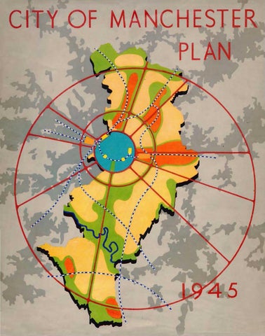
• For regional and advisory planning areas, see Diagram 1, opposite.
2
I CHORLEY R. P. C. 2 ROSSENDALE R. P. C. 3 WICAN R. P. C. 4 BOLTON R.P.C. 5 BURY R.P. C. 5 ROCHDALE R.P. C. 7 LEICH R. P. C. 8 WARRINGTON R.P. C. (PROPOSED) 9 MANCHESTER R.P. C , 10 OLDHAM R . P. C. II N. E. CHESHIRE R. P. C. 12 EAST CHESHIRE R. P. C. 13 NORTH CHESHIRE R.P. C. 14 MID·CHESHIRE No.4. R.P.C.(Port) 15 MID· CHESHIRE No. 5. R. P. C.
fuJ.g. Boundavie.s 2( Consli.luent local Aulhori lies
• !kgionol Planning Committus · Monchyttr { District R•!Jiono l SCALE
Of
~
MILES
OC===2---K 4 ==~6. . .8C===IO . .. . . . . . . ..m. . . ...U 20MILES
Diagram 1
Commi.llee
• Advisor¥ Plannin3 Commillee ~
-
Boundaries
THE ADMINISTRATIVE AREA OF MANCHESTER IN RELATION TO THE REGIONAL AND ADVISORY PLANNING AREAS.
3
committee in turn is represented, along with the regional planning committees of Bolton and District, Bury and District, Chorley and District, Leigh and District, Oldham and District, Rochdale and District, Rossendale, Wigan and District, North Cheshire, North-East Cheshire, East Cheshire, part of Mid-Cheshire No. 4, and Mid-Cheshire No.5, on the South Lancashire and North Cheshire Advisory Planning Committee. This, the first body of its kind in the country, has been in existence in its present form for some 20 years. It co-ordinates the work of its constituent district committees,
circulating the results of their research and helping them to deal with questions that are common to [ 13 all, or which arise in boundary areas. The Town Clerk and City Surveyor of Manchester are respectively the Honorary Clerk and Honorary Surveyor to both the Regional Committee and the Advisory Committee, and the staffs of both these bodies use the Manchester Town Hall as their headquarters. They are thus in constant touch with the city's planning staff and any common difficulty at any level can speedily be resolved. [ t4
THE FORM OF THE PLAN
In the following chapters an attempt is made to expound the Plan in the most easily intelligible sequence. Planning, however, presents not a succession of problems, each following the last in logical order, but a single composite problem whose solution must take the form of a complex of interdependent schemes, each of which affects, and is affected by, the conditions encountered and the remedies adopted in other fields. It will therefore be helpful to the reader to begin with an overaUglance at the prospect before us and a broad outline of the general structure of the Plan. [1s RESIDENTIAL DEVELOPMEl'.l'f
In many respects the Manchester citizen of 1650 was in a better position to enjoy a healthy life than the present-day inhabitant of Ancoats, Beswick, or Hulme. If the quality of his bouse was poor, and the sanitary arrangements primitive or nonexistent, at least he had a fairly large strip of garden and the open country was only a few minutes' walk away. To-day about 60 per cent of Manchester's houses are built at densities in excess of 24 to the acre. Most of these 120,000 houses are old and must in any event be rebuilt in the comparatively near future. Over 60,000 are considered by the Medical Officer of Health to be unfit for human habitation. Many are having to be demolished because they are structu rally unsafe, and many more have an estimated life of only two or three years. As far as the inner belt is concerned, therefore, the question is not whether complete redevelopment is necessary, but in what form and at what standards of density it should take place. Is Manchester prepared once again to give the country a bold lead by adopting 4
standards of reconstruction that will secure to every citizen the enjoyment of fresh air, of a reasonable ration of daylight, and of some relief from the barren bleakness of bricks and mortar? [16 There are some who believe that if redevelopment takes the form of large blocks of fiats, with trees, lawns, playgrounds and flower-gardens in between, it is possible to realise such standards without displacing a large proportion of the people now living in the congested areas. In support of their contention they point to the success of several Continental housing schemes of this type. There is, of course, an element of truth in the argument, but on mature consideration it will be found to over[ 11 simplify a vastly complicated problem. In the first place the Continental analogy is misleading. In the countries where workers' flats have been most generally popular, housing standards are markedly lower than in Britain, the climate encourages a gregarious outdoor life, and public transport is not sufficiently developed to permit the employees of concentrated industries to live in open surroundings. It would be a profound sociological mistake to force upon the British public, in defiance of its own widely expressed preference for separate houses with private gardens, a way of life that is fundamentally out of keeping with its traditions, [ 18 instincts and opportunities. Secondly, the advocates of large-scale flatbuilding greatly over-estimate the proportion of people now living in the congested areas who might thereby be decently rehoused on the site. Blocks of flats to accommodate the majority of the residents in Manchester 's inner districts would have to be so close together in relation to their
-~---
-----
-
--
-
THE WAY WE LIVE NOW
1.
The re deve lopme nt problem. Endless rows of grimy houses: no gardens, no parks, no community buildings, no hope.
2.
Slum clearance. This was a beginning: the people who lived here moved to the pre-war housing estates.
2
3.
The housing estates were an improvement: but the people live on main traffic routes, noisy, a danger to their children: they have no meeting places, no community life.
3
4.
Wythe nshaw e. A later developmen~ The main road by-passes the town; trees are preserved, schoo ls set in ample playingfi e lds ; but there is still no provision for community life, for full living. We can do sti ll better than this.
Plate 2
4
:.
·. .. .·.·.
:.-.; .· ··~:·~;:>.~;.....··;.·.. :·
·.
(;~
...
DISTR~IBUTION OF POPULATIO N REFERENCE EAOi SPOT REPI'?ESENTS 100 PERSC~S
/
:'
;
,.
SCAl£ OF
BLITZ 1940 1. Piccadilly in flames on the night of December 23rd. 2. T he corner of St. Mary's Gate and Deansgate. 3. The Free Trade Hall (interior view) once the home of the Halle! Orch est ra.
2
Here- in Piccadilly, St. Mary's Gate, Peter Street-in many places throughout the city there is the opportunity for re building ; for designing structures that will be worthy of our city. Wh en we build again, !et us take ful l advantage of this opportunity.
3
Plate 3 opposite
Plate 4
MANCHESTER THE REGIONAL CENTRE
1
Communications, Commerce and the Press 1. Manchester Docks. 2. Ringway Airport, terminal building . 3. Kendal Milne's store, Deansgate. 4. "Daily Express" building.
2
4
height and capacity that the lower rooms would get little daylight, communal lawns between them would soon be trampled into bare mud, and playground noises wou ld become intolerable. In other words, it is impossible to get rid of the effects of congested development simply by turning it on edge. Certainly more people would be displaced by redevelopment wholly in the form of separate houses with private gardens than by redevelopment wholly in the form of blocks of flats with communal gardens, but if the latter were designed to give the same standard of light, air and general amenity, the difference in numbers displaced would be much smaller than is commonly supposed. Moreoverand this is an essential point that is seldom given its due weight-if adequate space is reserved in the redevelopment areas for necessary provisions other than house-room (e.g., shops, playing-fields, public buildings and other communal facilities), the advantage to be gained in terms of the number of people who can be rehoused on the site by building flats instead of cottages dwindles into insignificance by comparison with the number who will in either case have to be rehoused elsewhere. [ 19 In short, the reconstruction of the most congested areas in accordance with decent living standards must in any event entail an overspill amounting to well over half of their present population. The rehousing of these people is a physical and psychological problem of the first magnitude. There will be room in Wythenshawe to accommodate about 36,000 of them, but about three times that number will have to be found homes outside the city boundaries in the near future. By no means all of these can be absorbed into existing communities in the vicinity of Manchester, and their re-establishment in a new satellite town is a project beset with financial and administrative clifficulties which may prove insurmountable unless new legislation enables the city to provide the necessary services and to retain the rateable value it thereby creates. Means must also be found to make the prospect of removal to new homes outside the city attractive to the people displaced; to this end a parallel dispersal of workplaces from tbe inner city area to the new settlements must be arranged as an integral part of the redevelopment programme. [20 Since the building of flats for people who want houses would be ineffective as a means of avoiding this overspill problem, or even of materially Plate 5 opposite
reducing its scale and urgency, the proportions in which it is proposed to mingle houses, flats and other types of accommodation have been fixed in the main by other and more relevant considerations. Of these the most important is the family structure of the population. For example, fiats will normally best suit the needs of single persons, but cottage-flats may be preferred by elderly childless couples, while three-bedroom houses will be necessary for families with two or three young children and should also be available for newly married couples. At the same time some older people will doubtless want to stay in their family houses after their children have grown up and left home. Broadly speaking, however, the proportion of dwellings of each type and size should correspond to the proportion of the family units to whose needs such dwellings are most appropriate. It is accordingly on this basis, modified where necessary to meet special circumstances, that the housing proposals in the Plan have been prepared. [21 THE CMC STRUCTURE
In deciding where these various types of dwelling should be put, and how the necessary communal facilities should be distributed, the aim has been to ensure : first, that every dwelling may have convenient access to such facilities; second, that residential and industrial areas may be distinctly (but not too widely) separated; and third, that the layout of the residential areas may be such as will foster a sense of community. With these ends in view, dwellings have been grouped in neighbourhood units, bounded by main roads, railways, or other physical barriers, and each containing enough churches, shops, playing-fields, primary schools and public houses for about 10,000 people, as well as a community centre, branch library and health sub-centre. Most of these amenities should be concentrated in a neighbourhood centre designed to serve as a focus for local social activities. [ 22 The neighbourhoods in turn have been grouped into districts, whose centres should be equipped with district shops, halls, cinemas, art galleries and such other attractions as cannot economically be provided for communities of less than about 50,000 ~op~
~
The city centre must serve the wider needs not 5
o nl y of these rcsidenliul districts, but also of the o utlying towns in the large region which looks to Manches ter us its economic and cultural capital. 111 ordc1· that il mny discharge this fu nction in a worthy unu cnicicnl manner it will httvc to be l.'>.lcnsivc ly rcannn gcd over n long period. In purt iculnr, the blighted nrca between Dcansgate nnd Sa lford , the ~ ite of Roman Manchester, must he rcvi tnliscd by <.lrnstic redevelopment and better com munica ti ons between the two cities. [24 Improved c:ommunicotions plainly constitute the key to the rc plunning of the central nrca. Both longdisluncc ond suburbnn railway lines need to be linked together. Th ' present passenger stations are obst)lctc und ill-sited : their a pproaches arc inconvenient nn J confi ned. The goods stations should he n.'movcd cntirt!ly from the central nrea. The w hol ~ sy!\tcm should b" modcrni ed and i ntegrated with u new nnd scienti fically de igncd highway network, cnpnblc or giving su fe. ..mooth nnd speedy pnssng' to n olumc of motor tronic far in excess thn l whwh t "f we the wur had already begun to ~ho l~ om prcs~n t streQt . s nn es entiat part of tht.' tran P~-'rt ~ h~nw, new bus tem1innls nnd car p.trks will huv' t0 b' pr"'' ided. ond ufficient land must t ~ rc~~.:rvcd nt Rin~w l )' t gh e the {a nchester rqd n nn nirp rt big enough to "CrY<.: as a terminal fo•· trum1 • ntincntul 'erviC\!s. [lS
or
t\lt ~ nn
\ t ~' 'T • , uge in tbi c mph~.., pr ": of evolu(t\.H\ .md adJu~tmt.'nt t n~ .. upttmely important f3ct
1\,,s ~'t'n k pl c- n t \ntJy in mind. Ianch t"r i" tirsr nn i t"'vt:\"m "'t th" c )re ~J ph ot f n of the ..lll\'St b.t~hh mdu:trmli~ed recion in the world. ' \ ., \'' 'frt hng. pur f any Pbn for ilancb ter. th l\'f rc. mu~t "'hy ill p , 'ble moo.n t promote. . nJ t " td tmpturmg. th~ full md -prosperous 1pi ' m ·nt 'f th" p\al tti n ~~~ in the .. mtt'u ·utrmg. .m i ;-omm re1ru a riviti "'to which th 'ity :md tt~ nvuon" '" thtir \\~th. P~.n, ~
Tl ttu:"ti
REAL
ning can help substantially towards the achievement of that purpose, especially by offering land and facilities in the right places for the introduction of those new enterprises which are so urgently required to balance the city's industrial structure. [26 At present Manchester is plentifully sprinkled with a reas in which obsolete factories and slum houses are inextricably intermingled, but has few sites to offer for new industries. The Plan proposes that selected zones, amounting in the aggregate to a larger acreage than is now in use for industrial purposes, and conveniently situated in relation to road, rail and canal transport, should be reserved for industrial development. To these zones, as well as to new industrial estates adjoining the new residential communities, the firms now established in areas which have been zoned as residential neighbourhoods should be induced to migrate as their present premises approach the end of their efficient life. Given full co-operation between the industrialist and the planning authority the redevelopment programme can be arranged to suit the convenience of the former ; the process of re-location and clispersal can then be carried out to the mutual advantage of the firms concerned and of the comm unity as a whole, and at a minimum cost to the p ublic purse. [ 27 Of the other principal features of the Plan-such as the proposals to remedy shortcomings in the amount and clistribution of public open space, to a bate (and ultimately to abolish) the pollution of the city's a tmosphere by smoke and fumes, to e~:pand its health and education services and to re'itnJi~e its cultural life-of these nothing more need at thi stage be said, since they do n ot involve !my ~Ubstnntial modification of the general frame\: "'r · as d~termined by the considerations outlined abo' , They do neYertheless constitute essential p:.uts of the PJun. for without them its objects cannot be fully achieved. -:s
T 0,~
""ill ba.'~ to
£ 'IB£ P~ '"
boo-. Th"' ~~let order .:md durution of the -m!!:eS in ~' · pru:ticub.r ~ "tion ' of the city will -be ~''d~~ nuct depend on n number of unpredidnb! ft.~oTS, uch 3S the ~ of rhe M.tiQoo) hou..~g progrruum ~ the a' aiJJbility of t<noour :md nu:l!enw ~ th" ~ f industry and
commerce, and- most important of all- the strength of the popular wi ll to go on saving and thereby to maintain the necessary flow of capital. Broadly speaking, however, it is estimated that the proposed residential redevelopment should be accomplished before 1975, though the rest of the scheme is unlikely to approach ultimate com[29 pletion in less than 50 years. It is, of course, assumed that adequate powers and financial facilities will be provided by the State, for otherwise no satisfactory scheme could possibly be put into effect. It is hoped that the publication of these proposals, by drawing attention to the practical difficulties encountered in the detaHed replanning of a large city, will serve to indicate the character of the problems still requiring legislative action and the inadequacies of the present planning machinery, and that they will thereby assist the Government in the formulation of a national planning policy. [3o To forecast the total expenditure involved in carrying out the Plan would be virtually impossible; nor would such an estimate serve any useful purpose. It would be no less difficult-and equally meaningless-to assess in monetary terms what the community would gain from good planning in the way of enhanced municipal income, time saved,
better health and higher productivity. We must bear in mind the cardinal fact that a major proportion of the projected work will in any event have to be done, with or without a plan, during the next 50 years. The relevant question, therefore, is whether planned redevelopment will cost more or less than unplanned redevelopment, and whether it will bring in greater or smaller returns to the community. The answers to both questions strongly reinforce the case for comprehensive [31 planning. Nevertheless the financial aspect must be carefully considered at every stage, for there is a limit to the amount which any generation is prepared lo lay out for benefits which, however great, will largely accrue to succeeding generations. Under a flexible plan, however, expensive redevelopment can be slowed down in times of full employment and financial stringency and accelerated when private capital investment falls off. Moreover, the monetary burden at any given period can be kept within bounds by skilfully arranging the programme so that some redevelopment is quickly followed by satisfactory financial returns. There should certainly be opportunities in and around the central area of the city for such remunerative [32 enterprises.
THE NATURE OF THE PLAN Within the general framework outlined above there will be plenty of scope for taste and imaginative vision to play their part in fashioning the detailed form and structure of the Plan. Yet even here we do not start with a clean slate. The planner must take into account that indefinable but unmistakable spirit which is inherent in any old-established community. The character of a city is created not merely by its particular topography and climate, but also by the temper of its citizens, by their traditions, and by the ways of life they have evolved over a period of centuries. Manchester bas an air of sturdy independence, of common sense and sociability, that is peculiarly its own. Beneath its somewhat grim and forbidding exterior glows a rich local colour. It is still profoundly influenced by ideas and customs which have their roots in the industrial revolution, and the cosmopolitan groups it then attracted to its workshops and markets have become an integral
part of its life. Admittedly not all our traditions· have an equal claim to be embodied in the Plan; some, indeed, are wholly bad, and these must be ruthlessly eradicated ; but the best of them should be allowed to play their part in shaping the city of to-morrow. [33 A monumental plan in the grand manner, with showy vistas and processional ways, would be totally out of keeping with the essentially practical character of Manchester. That, however, is no reason why we should perpetuate the spirit of sheer materialism and indifference to beauty which has been mainly responsible for the undistinguished appearance of the present city centre. On the contrary, the ultimate achievement of the city beautiful should be our constant purpose. The true ideal must surely be a combination of beauty [34 and utility. How nearly the present proposals approach that ideal is for you, the reader, to judge. It cannot be 7
too strongly emphasised that they are only tentative proposals. It is an avowed purpose of their publication to stimulate comment and criticism, and due attention will be paid to the views they evoke when the City Council comes to adopt an official scheme. It is therefore of the first importance that you, the citizens of Manchester, should
8
give careful thought to the problems involved and to the solutions here suggested, in order that your criticisms may be helpful and constructive. Reflect upon them; discuss them with your friends; and then let your voices be heard, whether in praise of what you like or in condemnation of what you [35 think unworthy of your city's future.
Plate 6 opposite
THE COUNTRY NEAR MANCHESTER
Beyond the city lies th e country beloved of Mancunians, th e canalside walks, the bleak Derbyshire hi lls, th e moor lands of Lancashire an d th e soft wooded undul ations of Ch eshire.
1. The O ld Packe t House, Bridgewater Canal. 2. Kinder Scout, Derbyshire. 3. Trough of Bowland, Lanes. 4. Mere, C heshire.
"It were an injury and sullenness against nature not to go out and sec her riches and partake in he r rejoicing with heaven and earth." Milton
4
MANCHESTE it IN THE YEA ~
1793
Plate
2
THE HISTORICAL BACKGROUND "People will not look forward to posterity who never lool¢ backward to their ancestors." Edmund Burke
THE STRUCTURE OF A CITY is always changing, not
only by expansion but also through internal reconstruction. A few glimpses of Manchester's past will be enough to illustrate the main stages in its continuing transformation, and will thereby help to put the future changes here proposed in their true historical perspective. [36 MARKET TOWN
Leland, for example, writing some four centuries ago, tells us that Manchestre on the south side of the Irwell River standeth in Salfordshire and is the fairest, best builded, quikkest and most populous town of Laocastershire, yet in it is but one paroch church,* but is a college and almost throughout double aisled of very durable squared stone whereof a goodly quarry is hard by the towne. There be divers stone bridges in the town, but the best of three arches is over lrwelL This bridge divideth Manchestre from Salford the which is a large suburb of Manchestre. On this bridge is a pretty little chapel. The next is the bridge over the Irk river on which the college standeth as in the very point of the mouth of it. On Irk river are divers mills that serve the town.
At this period almost all the buildings in Manchester, except the Cathedral and College, were of oak half-timber work, filled in with plastered wattle-and-daub and roofed with stone slates like those still to be seen on Chetham's Hospital. [37 About 50 years later William Camden in his "Britannia" noted that Manchester surpassed all neighbouring towns in "neatness, populousness, woollen and other manufacture". [38 From these and other similar accounts it is apparent that before 1600 Manchester was a thriving and picturesque market town, built around the Cathedral area. It was also the centre of a large parish covering not only the limited township but virtually the whole of present-day Manchester (excluding Wythenshawe), Denton, Droylsden, Failsworth, Heaton Norris, Reddish, Salford and Stretford. [39 According to the records of the Court Leet, the town in 1650 consisted of about 15 streets, com.. Now the Cathedral.
prising the two market steads (off the lower end of Market Street), Market Stead Lane (now Market Street), St. Mary's Gate, Old Millgate, Long Millgate, Miller's Lane, Deansgate, Smithy Door (on the site of Victoria Buildings), Cateaton Street, Smithy Bank (running approximately from the bottom of Cateaton Street to Victoria Bridge), Hanging Ditch, Toad Lane, Shudehill, Fennel Street and Hunt's Bank. The River Irwell had one bridge to Salford, while the Irk had four small bridges: one at Hunt's Bank to Strangeways Park; the second at the end of Toad Lane (Mill Brow); a third, named Tanner's Bridge, at the end of Miller's Lane (now Miller Street); and a fourth on the site of the present Scotland Bridge, leading from Long Millgate to Red Bank. [4o When at the close of the century Cecilia Fiennis viewed the town from the roof of Chetham's Hospital she considered it "a fair and pleasant prospect", the old houses being of timber and the newer residences of brick and stone. She made particular mention of the size of the cloth market, which occupied two complete streets. Early in the following century the population of Manchester, then considered a sizeable town, was approaching [ 41 10,000 persons. Buck's "South-West Prospect of Manchester", dated 1728, shows that a new architectural style had been introduced by the building of St. Ann's Church. The surrounding district, comprising St. Ann's Square, St. Ann Street and Lower King Street, was built during the first half of the eighteenth century. [42 The extent of the built-up area in 1783, and of the redevelopment then in progress, may be gathered from this passage in the petition for the erection of St. John's Church, Deansgate: From the bottom of Tib Lane in a line with the top of King Street to the Dissenters' Chapel the buildings have increased in the last 50 years to the west boundary of the Tib taking in the whole area of land to Market Street Lane except Browns Hall and a house with dye houses and a corner of Pool-fold where tbe new market has recently been made. From the head of Tib Lane to Market Street Lane there are some cottages on the waste now demolishing, and tbe land planning iuto streets towards the infirmary. (43
9
REFERENCE Arzo built up bdcr<t ··
-
1650.
. . .. •
·• btt ... ~zn 1650- 1750.. ~
··
··
··
··
•.
..
-
..
..
..
.. since Sco • ~
17SO-I!J45...1illli!iJ
1845 -1915 ... ~ 1915 ... _ .....
of '.II LES
CJ
DEVELOPMENT
OF MANCHESTER IN PERIODS
Diagram 2
This somewhat obscure quotation indicates that
the area bounded by Cross Street, Market Street, Fountain Street, Booth Street and Tib Lane (as they now exist) had been newly developed, while new streets were being constructed between the present Fountain Street and Piccadilly Gardens. [44 At the end of the eighteenth century part of the land around Piccadilly and the district southwards 10
to the Medlock by Garratt Hall stiJl consisted of open fields, as did some of the environs of St. Peter's Church, which (it will be recalled) were still known as St. Peter's Fields at the time of Peterloo. One cotton mill stood near a new bridge (on the site of the existing bridge) on Oxford Street, together with the first three houses erected in that locality (on land now occupied by Oxford
Road Station). Until the erection of this bridge all traffic to Manchester from the south had gone by way of Garratt Hall, which was situated on the banks of the Medlock on what is now Princess Street. King Street was one of the most fashionable streets and housed the professional classes with a few prosperous merchants. Mosley Street, which was apparently laid out some time after 1750, was described by Dalton in 1793 as "the most elegant and retired street in the town". [45 THE INDUSTRIAL REVOLUTION
By 1800 the town was expanding rapidly and the admirable urban tradition established during the preceding century was being endangered by the crude and powerful forces of the industrial revolution. The development of the steam engine, the invention of textile machinery, and the discovery of new ways of using coal and iron resulted in an enormous release of energy, which showed itself in the phenomenal growth of industrial cities. A complete revolution was brought about in all established ways of life and work. The transition from the old method of spinning and weaving in the home to mass working for au employer in the factory was rapid, in spite of determined opposition on the part of the workmen. In Manchester conditions were extremely favourable to industrial expansion; there was already an established local industry with a hard-working population, water power was cheap and plentiful, and good transport facilities were available with convenient access to coal and other raw materials. [46 The old Georgian urbanity was soon swept away by the new industrial power, which was to become the primary force in shaping the city. Joseph Aston, writing in 1816, recorded that the Irk had perhaps more mill seats on it than any river of its length in the kingdom, and that the banks of the Medlock were the seat of many dye houses. Aston also noted that "Ardwick Green, which forty years ago was a distant village, but is now joined to the town by continued streets ... is perhaps one of the best built and most pleasant suburbs in the kingdom; to which its elegant houses-its expanded green-and the lake in the centre, all contribute". [47 The general aspect of the city during these years of revolutionary change must have been one of the utmost confusion; new classical commercial and
public buildings, together with new utilitarian manufacturing works, stood cheek by jowl with old black-and-white residences. Mr. John Holden wrote less than 100 years ago that "many of the streets were crooked and narrow, they were paved with cobble stones very imperfectly set and punned with a rammer". It appears that some of the principal streets were paved with large square setts laid in cinders; all the city thoroughfares were unbelievably muddy and filthy. As late as the middle of the century the number of half-timbered houses was still large, but was gradually being reduced by the necessity for street widenings, such as the Market Street improvement of 1822. Mills, dyeworks and other heavy manufacturing plant occupied many central positions, including Albert Square and its environs and the site of Central Station. The area bounded by Faulkner Street, David Street, Charles Street and Oxford Road was completely covered by industrial buildings; a large area in the vicinity of London Road was similarly developed. [48 Several important new buildings, symbolising Manchester's civic pride and growing cultural consciousness, were erected during the first half of the century: among them were the Portico Library, the Art Gallery, the Athenaeum~ the Town Hall in King Street, and a number of banks. Our city was already a centre of world trade and a meeting-place for business men from all parts of Europe. [49 This period saw the establishment of the railways. Manchester's first railway station, the terminus for the Liverpool-Manchester line, was opened at Water Street in 1830. In 1840 the BirminghamLondon line opened a station at Bank Top (now London Road) and in the same year the East Lancashire Railway Company opened a station at Hunt's Bank (now Victoria). The bridge carrying this line over the road and river is still in use. The railway stations of this period were very small compared with present-day standards; they were about the size of the wayside station of to-day. [so Gas as a means of lighting was first used in 1805 at Lee and Phillips's factory in Salford. In 1817 the Police Commissioners, who were at that time responsible for the local government of the town, erected their first gasworks at Water Street for the purpose of lighting the central streets. In 1824, by the Mauchester Gas Act, the town was L1
empowered to manufacture and sell gas to the [ 51 general public. Cities, during the early industrial era, acted as magnets to the population of the countryside; the rapid drift of agricultural workers from the country to the city, in search of work, was accompanied by a considerable immigration of poor Irish and an excess of births over deaths. As a result the population, which in 1801 bad been 72,275 persons, rose to 242,983 in 1841, and to 303,382 in 1851. [52 At that time Ancoats was still a thriving district; Ardwick, Rusholme and Victoria Park were highclass residential areas, and Greenheys, Harpurhey, Miles Platting and Newton Heath were being laid out for building. [ 53 The housing of the working classes was indescribably bad. Evidence was given to a Select Committee in 1842 that the labouring classes lived, in the main, in back-to-back houses covering about 16 square yards. It was concluded that to prohibit the building of back-to-back houses would prove too expensive to be practicable, but within two years the Manchester Borough Council accepted this reform in the Manchester Police Act of 1844. [54 To sum up, the first half of the nineteenth century in Manchester was an era of unprecedented change, of ruthless and uncontrolled energy and confEct, of crude materialism and blind, unreasoning confidence in the beneficence of the new industrial forces. Manchester was transformed rapidly from a genteel and prosperous provincial town to one typifying the horrors of the new industrialism. It paid the price of world-wide importance by the sacrifice of beauty, health and order. The new mechanical age which held such promise for the betterment of mankind had begun badly, and in providing luxury for the few had created misery [55 for the many. TilE EXPANSIONIST PHASE
By the middle of the century the revolutionary period was over, and an era of apparently boundless expansion had set in. Manchester's established importance as a commercial and industrial centre was symbolised by its elevation to the status of city in 1853. In that year it occupied 4,293 acres, which is substantially less than the area of Wythenshawe to-day. By 1914, at the end of this expansion 12
period, its acreage had grown six-fold; except in tbe south-west, where Wythenshawe has since been added, its boundaries had reached their present positions. [56 The years between saw the development of a remarkably progressive spirit in public and private affairs. At no other stage in its history could it so truly have been said that Manchester led the way in all spheres. Its mounting prosperity was reflected in the erection of the Free Trade Hall, the Royal Exchange, the present Town Hall, the Assize Courts and Rylands Library. The Ship Canal, opened just before the turn of the century, gave a further impetus to its commercial ascendancy. Its emergence as a focus of cultural activity was marked by the great art treasures exhibition of 1857, and later found expression in the establishment of Owens College, soon to become the largest single provincial university, and in the opening of England's first free public library at Campfield. It was at this period, too, that Manchester began to win a world[57 wide reputation as a home of good music. It was also at this stage that the transition from manufacturing city to mercantile metropolis took place. Mills and factories originally situated in the centre of the city began to move outwards and were replaced by new commercial buildings. Much of the warehouse property still standing was erected, including the famous Portland Street warehouses. It was admittedly not a period of architectural distinction, but standards of building and sanitation were substantially raised : more attention was paid to air space, and the old low-storeyed, ill-lit warehouses were largely superseded by lofty buildings with large window areas. Considerable attention was also given to further street widening in the city centre, though improvements consistently lagged behind actual needs. Meanwhile an increasing amount of central land was acquired by the railway companies. In 1866 London Road Station was completely rebuilt; the Midland and Cheshire lines opened Central Station in 1880, and the Lancashire and Yorkshire Railway was considerably extended. Several important goods stations were also built in the central area. [ss At the same time an awakened public conscience insisted on drastic housing reforms which raised working-class living conditions from the utmost degradation to a level not equalled in other indus-
-
2
THE HISTOR Y OF MARKET STR EET
1
Planning and change are not new features of the twenti eth century. 1. 1823. Looking towards the Exchange. Market Street Lane, as it was then called, was steep and narrow-at this point about five yards wide. 2. 1829. The view from Piccadilly. 3. 1830. Market Street was widened and levelled. The drawing shows labourers at work on demolition. 4. 1944. Looking towards the Exchange. Compare this with 1. 5. 1944. The view from Piccadilly. The same viewpoint as 2.
3
4
5
----Plate 8
150 YEARS IN MAR KET PLACE 1. 1792. The monument marked the site of the first Exchange, pulled down in that year. 2. 1821. The drawing shows the extreme narrowness of the lower end of Market Street. The second Exchange occupied the same site as the Royal Exchange of ro-day. 3. 1944. Looking up Markee Street. Compare this with No. 2. 4. 1892. Victoria Market. 5. 1939. Market Place from the same viewpoint.
2
4
Plate 9
trial cities. A series of bye-laws secured more space between houses and better sanitary equipment. The cellar dwellings which had been numerous during the first half of the century were all closed, and back-to-back houses were demolished or reconditioned. Meanwhile high-class residential districts in the inner ring declined rapidly and the flight of the wealthier citizens from the foul air of the city to suburban areas became more pronounced. [s9 Thus, though town planning as such was unknown, changing conditions had completely altered the face of Manchester, transforming its residential pattern and the character of its central area. [60 STABILISATION
By the end of the century it was obvious that the rate of expansion was getting slower, and by the outbreak of the Great War in 1914 Manchester had settled down to a phase of stability. After the war came a brief boom arising from a shortage of consumer goods, followed by a general decline in the export trades. Sporadic redevelopment of the central area continued, and during the 20 years between the wars a number of modern buildings were erected. The Royal Exchange was extended, and the Central Library and Town Hall extension were added to the civic group. Among other new buildings were Ship Canal House, the Midland Bank, Arkwright House, Blackfriars House, Kendal Milne's store, Rylands' warehouse and the "Daily Express" building. But very few new warehouses were built; the central area was taking on an administrative rather than a commercial character. [61 Since redevelopment took place in small uncoordinated sections, new buildings were often much too tall for the ground area which they occupied. Architectural balance was sacrificed to the necessity for making the best of difficult sites (witness the awkwardly shaped Town Hall extension), while the most effective use of modern building methods and materials was virtually precluded. [62 A complete revolution took place in transport. The capacity of the corporation transport system was greatly enlarged, thanks partly to public appreciation of the convenient service given by tram or bus, and partly to the outward movement of population from the inner wards to the outer
suburbs. The tram was to a large extent superseded by the motor bus, and later still on some r outes by the trolley bus, while the use of the private car increased enormously, both for business and for recreational purposes. Road haulage developed to significant proportions, challenging the previous railway monopoly of long-distance freight traffic. The final stage in the development of municipal transport was the opening of the corporation airport at Ringway in 1938, and the establishment of regular local and Continental air services. [63 Two important new roads, Kingsway and Princess Road, were constructed, and a number of street widenings in the central area were necessitated by the vastly changed traffic conditions. The Cannon Street improvement, first projected as long ago as 1896, was the subject of two Parliamentary Bills passed in 1909 and 1930, but was not completed until the present war- at much greater expense than would have been incurred had the scheme been carried out when powers were first obtained. It is now realised that even the widened Cannon Street is still inadequate for the volume of traffic which it will be required to carry in the post-war period. [64 Industrially, the period was one of decline in the basic exporl industries upon which Manchester's prosperity was founded. Textiles and heavy engineering suffered severely during the years of depression and shrinking world markets, and showed signs of recovery only under the artificial stimulation of the Government defence programme. Industry showed an increasing tendency to move away from the city, in some cases to other parts of the region, but in other cases away from the North completely, leaving behind unemployment and depression. A more hopeful sign, however, was to be found in the gro~h of light engineering, the electrical trades and the chemical and rubber industries, which promised to offset, in some degree, any persistent depression in the [6s basic industries. The improvement and extension of municipal services was a marked characteristic of the period. The corporation assumed responsibility in many new spheres, undertaking considerable housing schemes and becoming a landowner on a large [66 scale. As a result of the cessation of building during the 1914-1918 war~ the city was faced in 1919 with a 13
shortage of approximately 52,000 houses. In an attempt to meet such needs, and to encourage the building of good-quality houses which might be let at low rentals, State subsidies were offered to public and private builders of small houses. Unfortunately, the general cost of building had risen to such an extent that, even with the help of subsidies, it had become virtually impossible for private enterprise to build houses and let them at rentals which the working classes could afford. When these subsidies were withdrawn private enterprise continued to build a majority of the houses erected during the earlier years of this period, so that eventually it was necessary for local authorities to increase rapidly the pace of their housing programmes to establish a balance between working-class and larger-type houses. Thus working-class housing became almost exclusively the responsibility of the corporation; of 52,000 houses erected in the city between 1919 and 1939, approximately 30,000 were built by the [67 local authority. The standard of working-class housing was immeasurably improved, thanks largely to the sound and progressive recommendations made in the Tudor Walters Report. The acute post-war housing shortage and the lack of adequate building land within the city were directly responsible for the acquisition of Wythenshawe and its final incorporation in 1931. A steady movement of population from the inner residential districts to the new suburban housing estates on the outskirts took place, accompanied by an accelerating movement of wealthier families from the city to new [68 residential districts, mostly in Cheshire. The rising standard of living and changing modes of life were reflected in numerous other ways: in the building of cinemas and other places of amusement, in larger shops and new restaurants, and in an enormous expansion of the clothing and luxury trades. Possibly the changed position of women, who now took their places with men in shops and offices, was responsible in part for these [69 developments. THE NEXT STAGE
Thus the city has evolved, gaining in importance and prosperity, but often at the expense of the living conditions of its inhabitants. History shows that considerable areas of Manchester have been 14
drastically redeveloped several times since 1650. It shows, too, that over the last 150 years the city bas assumed an increasing responsibility towards the individual citizen, particularly in such matters as water, gas, and electricity supplies, street lighting, sewage disposal, housing, transport, public [10 health, education and recreational facilities. It is in the natural course of events, therefore, that the city should assume responsibility for town planning, which alone can ensure an amelioration of the present unsatisfactory conditions. Such planning must envisage changes in the next 50 years as drastic in scale as those which took place during the industrial revolution. To the inhabitant of the compact town of 1800, the sprawling monster of 1850, with its factories, slums, new roads and railways, would have seemed as incredible as a modem corporation housing estate to the cellar-dwellers of 1850. Similarly in 25 years from now about one-half of the houses in the city may have been swept away and replaced; so also may a considerable proportion of the commercial and industrial buildings. [11 The achievements of the past are considerable, and should not be underrated. The immense vitality and determination which transformed Manchester in 50 years from a town of 72,275 inhabitants to an industrial city of international importance should not be dismissed as merely anti-social in character. The real tragedy of this early industrial era is to be found in the fact that no co-ordinated purpose or plan restrained the individualism of industrial pioneers. Had it been possible, in the early stages of industrialism, to take a long view of the future of the city, an incalculable amount of money, effort and distress would have been saved. [12 The people of Manchester have never failed to shoulder their responsibilities, even at great sacrifice to themselves. The example of the Manchester cotton operatives, who during the American Civil War resolutely faced starvation rather than assist the cause of slavery, makes one of the heroic stories of the world. Nor has the attitude of the city administration towards necessary reforms been unprogressive; indeed, Manchester citizens have good cause for pride in the early campaigns of the city council against unfit dwellings. A forward planning policy is, therefore, in keeping with [73 Manchester's established traditions.
CHANGING MANCHESTER 1. The house of Dr. White, who originated the idea of a public infirmary in the town, on the corner of King Street East and Cross Street. This graceful Georgian building, then on the outskirts of the town was replaced by 2. The Town Hall in 1825. Later the building was used as a Reference Library. 3 Lloyd's Bank now stands on the site. 4. King Street in 1866. 5. It is sti ll a fashionable shopping street to-day.
4
2
5
Plate 10
Colour of fi rst line denotes bui lding user. Colour of second line denotes age of buildi ng. Colour of third line denotes heigh t o f bu ildi ng . Colour of fourth line denotes condition of building. Principal public utility services w ith sizes also indica ted.
CIVIC SU RVEY SHOPS
Colour denotes age of industrial property . Depth of colo ur denotes condition and bl ack figu res indicate number of storeys.
BASIC SURVEYS
Colour over front half o f sho p denotes width of frontage. Colour over back half of shop deno tes user. Symbol in red denotes type, e.g., em pty, lock-up, baseme nt, etc.
INDUSTRIAL PREMISES OPEN SPACES Colour d enotes possi ble use of u ndeveloped land . Gree n hatched green = land s ui table for o r namenta l park. Yellow = land s ui table for bui ld ing d eve lopmen t, etc. Grey = la nd not su itable for development.
I
3
BASIC SURVEYS "The orderly arrangement and graphic presentation of these data through maps, statistical charts and photographs are important aids in clearing the mind of confusion, partial observation and misleading generalisation formed on the basis of insufficient evidence." Lewis Mumford
ALL GOOD PHYSICAL PLANNI NG for the future
must be solidly founded upon present fact. It is essential that complete data should first be compiled on the characteristics, condition and circumstances of all land and buildings within the city boundaries. Surveys have accordingly been made of the present character and use of land, and information collected concerning the use, age, height and condition of every building within the [74 administrative area. LAND SURVEY
In order to reveal the extent of existing open space, whether public or private, a complete survey of all undeveloped land has been made and recorded on a set of 36 Ordnance sheets (1 /2,500 scale). A portion of this map is illustrated on Plate 11, opposite. [75 This survey shows, by means of broad colouring and coloured edging, all public open spaces and their present use as playing-fields, playgrounds, or ornamental rest gardens, together with the extent to which organised-games areas could be enlarged if required. It also records private open spaces, [76 which should be retained. Together with the open spaces already possessing an amenity value, other undeveloped land has been recorded on the same maps by an extension of the original system of notation to the following categories : ( 1) Land capable of future development, being (a) ready for building, (b) previously used for tipping purposes, but now suitable for building, (c) suitable for building, but which cannot be drained without excessive expenditure of public money. (2) Land unsuitable for future development because of (a) steepness, Plate 11 opposite
(b) liability to flooding,
(c) the present working of its natural resources (for example by brickworks), (cl) the past working of its natural resources (e.g., land either requiring levelling by tipping before development can take place or awaiting the settlement of tipping already completed). (3) Permanent allotments or small holdings. (Wartime allotments on land in categories (I) and (2) above have been differentiated on the [77 maps by coloured hatching.) For each of the 36 Ordnance sheets a schedule has been prepared giving the precise location and area of all plots of undeveloped land, together with relevant comments on their present and possible future use. [78 This survey has been found invaluable as a guide to the possible extension of existing open spaces and to the siting and layout of future public open spaces in relation to other forms of development. [79 CIVIC SURVEY
For the purpose of the survey of buildings it was necessary to revise Ordnance sheets covering areas which were s:urveyed at different periods between 1931 and 1935, and to have them enlarged to double the scale of those used for the purpose of the land survey. In all, 108 sheets, each 40 inches by 27 inches, were used in the compilation of this survey. An illustration of part of one of these sheets, on the scale on which the survey was made, [so is given on Plate 11, opposite. The use, age, height, and condition of every building in the city were recorded on the maps by means of a series of narrow bands of colour drawn parallel with the main frontage of each building. The colour band or strip next to the street frontage indicates the use to which the building 15
is being put, while the following bands have been graded in their intensity to show the relative age, height and external condition of the buildings; the paler colours in each band indicate buildings of greater age, lesser height and poorer condition respectively. Thus a block of buildings having bands of intense colours indicates a structure of some importance, i.e., of relatively recent construction, fair height, and good condition. [81 The survey provides at a glance a comprehensive guide to the nature of all buildings and indicates whether demolition is likely to be costly and difficult, or whether property is now obsolete and ripe for demolition. From this point of view it has greatly assisted the planning of the routes of new roads through developed areas, especially within and near the city centre. [82 On the same survey maps the positions and sizes of gas, water and electricity mains, sewers and any special services, such as hydraulic power supply, have also been recorded. This facilitates an appreciation of the costs which would arise if roads were closed or diverted. [83 Although the information recorded on these two principal series of maps is complete in itself, it was found desirable, for the particular study of certain essential problems, to recast some of it in a manner appropriate to each of these problems as they came under review. For such specific purposes additional maps and schedules have been prepared. [84
that there is a considerable acreage of undeveloped land. The land survey, however, indicates that most of it is unsuitable for building purposes. [86 LIFE OF PROPERTY
Further maps have been prepared indicating a combination of age, height and external condition, and hence the likely comparative durability, or " life", of buildings. The colour notation used is similar to that of the civic survey maps, in that the more intense colours represent buildings of fairly recent construction and good condition, while the paler colours represent buildings whose age and external character suggest the likelihood of earlier redevelopment. [87 It is in relation to the possible order of redevelopment over whole areas that these maps have been most valuable. They have also proved useful in suggesting routes for proposed new major roads, from the point of view of minimum disturbance to important property. It will be appreciated, however, that without a detailed internal examination no accurate estimate of the likely lasting quality of any property is possible. These maps do not take internal conditions into account. Final decisions, therefore, have not been made by reference to them alone; they have, however, served as an excellent guide to the preparation of draft redevelopment proposals pending the completion of more detailed surveys of particular areas. [88
BUILDING USE
AGE OF HOUSING
A set of 46 Ordnance sheets records the particular purposes for which buildings are now used. An example of this survey is shown on Plate 11, facing page 15. The various types of building distinguished by colour notation include houses, shops with living accommodation over, lock-up shops, public buildings, licensed premises, industrial and special industrial premises, and garages. It is thus possible to appreciate at a glance the predominant use of buildings in any area. The same information has also been recorded on a composite map covering the whole of the city area to a scale of six inches [8s to one mile (see Plate 12, facing page 37). For the purpose of recording the areas of both developed and undeveloped land, a schedule has been prepared giving detailed particulars of surface utilisation in each ward of the city except Wythenshawe. This schedule (Appendix A, Table 1) shows
Before the first Town Planning Act, styled the Housing and Town Planning Act, 1909, housing development was largely controlled by local byelaws made under various Housing and Public Health Acts. Consequently the condition of residential development shows marked changes in certain distinct periods beginning with the passing of each of these new laws. A survey has accordingly been made of residential property in the city, and recorded on a six-inches-to-one-mile Ordnance map (illustrated on Plate 69, between pages 174 and 175), the age of houses being shown in periods [ 89 by colour notation. It should be noted that although the Act of 1909 gave some consideration to the collective grouping of buildings and to density restrictions, it was not until the Act of 1919 that any compulsory measure of town-planning control was introduced; in point
16
of fact, it was only after 1920 that the density of urban development substantially improved. The large proportion of land in the outer city areas developed between the two wars should also be observed. [90 SPECIAL SURVEYS
For the purposes of future zoning it has been found necessary to consider certain types of building separately. To bring out the existing character and circumstances of these distinct types, separate age, height, and condition maps have been prepared. In each case the information has been abstracted from details recorded on the civicsurvey maps and reproduced to a scale of 12 inches to one mile. The colour notation on these maps relates only to age and condition, the height of buildings being recorded by figures on each separate block. As in the case of the civic-survey maps, intense colours indicate premises in good condition and pale colours those in poorer condition. [91 A set of 11 Ordnance sheets has been used to record the state of industrial buildings. A portion of one of these sheets is illustrated on Plate 11, facing page 15. This survey has been of considerable assistance in the selection of those existing industrial nuclei which ·it would be expedient to retain and develop into future industrial zones. Not all areas in which industrial premises predominate have been considered suitable for future industrial use; in some cases the fact that the buildings are old and in poor condition has indicated that they might well, in time, give place to other forms of development. [92 Another set of maps shows the existing situation, quality, and capacity of blocks of warehouses in relation to the commercial buildings of the city centre and to neighbouring (predominantly industrial) areas. [93 All banks, offices, and commercial buildings in the central city area have likewise been recorded on maps to be used in considering the interrelationship of such buildings. [94 A map showing shops as distinct from other premises completes the series specially relating to the central area of the city. This map has been a valuable guide to the potential capacity of shops in the city centre and to their length of frontage, both of which, it has been considered, should at least be maintained in future proposals. [9s
In addition, a separate survey of shops has been made throughout the city and recorded on Ordnance sheets (1 /2,500). A portion of such a sheet is illustrated on Plate 11 , facing page 15. A schedule has also been prepared recording the trade or business of each shop together with its length of street frontage and the quality of its external fabric. Shops of the same or like trades in proposed redevelopment areas have been grouped together and their sizes classified according to frontage, with relevant comments on their condition. This information has facilitated the assessment of future shopping requirements in particular districts of the city, especially in connection with neighbourhood-unit planning. It is summarised in Table 2 of the Appendix, page 210. [96 DENSITY OF HOUSING
A comprehensive appreciation of the density of existing houses and of the need for dispersal of population by redevelopment and new development has been made possible by two special density maps to a scale of six inches to one mile, one of which, showing present densities by colour notation, is reproduced on Plate 68, facing page 174. The other shows the density of population living within the city area and is illustrated on Plate 3, between pages 4 and 5. In this case density has been indicated by a system of dot notation, each dot representing 100 persons. [97 A combined interpretation of the density and age of property maps bas helped to determine the [98 priority of certain areas for redevelopment. REGIONAL SURVEYS
Although civic-survey maps, to the same scale as those for the city itself, have been prepared for all the more densely developed parts of the region, it is obvious that the intense study which has been devoted to Manchester would not be warranted in some of the more openly developed areas. However, detailed surveys have, where necessary, been carried out, and their findings forwarded to the Regional Planning Committee, by the constituent local authorities. [99 Tbrouahout the preparation of these essential surveys ~he closest liaison has been maintained between the City Planning D epartment, the Regional Planning Office and the surveyors to the several constituent local authorities. [too 17
~
\
T I
K AU Of .....cs 0
ZONES IN WHICH GENERAL STATISTICAL DATA HAVE BEEN TABULATED
DISTRICTS IN WHICH INDUSTRIAL DATA HAVE BEEN TABULATED
Diagram 3
THE SOCIAL SURVEY ITS LIMITATIONS
Theoretically, the ideal Plan is that which, in the given set of physical and other circumstances, most economically satisfies human needs and desires. Having found out exactly what these circumstances are in Manchester, the next logical step would seem to be to make an equally exact and exhaustive survey of what the people of Manchester want; a correlation of the two would then -in theory-dictate the perfect Plan. But planning can never be an exact science in this sense, because in some respects the human factor is neither stable nor susceptible of accurate measurement. The statistical technique of assessing public opinion has made great strides in recent years, but its refinement only serves to emphasise the strictness 18
of the limits within which its conclusions are [ 101 valid. For example, it would doubtless be possible-though expensive--to find out within a negligible margin of error what proportion of our citizens feel that they would rather live in a new satellite town than in a redeveloped inner suburb. But it would not be possible to reach any reliable conclusion by comparing the answers of those now living in Wythenshawe and of those who have always lived in Hulme; still less would it be possible to estimate with any degree of scientific precision how the answers of either group might be affected by experience of the entirely different conditions proposed in this Plan. In any event the present shortage of man-power and the wartime disrup-
tion and dispersal of families put any such comprehensive inquiry out of the question. [1o2 It must not, however, be inferred that in default of a certain knowledge of what people want town planning is based on arbitrary assumptions, or simply on the planners' personal convictions as to what they will and ought to want. Fortunately many of the basic human needs are not only measurable with a fair degree of accuracy ; they also remain constant over long periods of time and do not appreciably differ from place to place. Consequently, in respect of all these fundamental requirements, a large body of reliable information is already available, built up from countless social surveys and medical researches conducted at various times and places in conditions more favourable than those which now obtain. Thus, whereas it was necessary to survey in detail the physical character and use of land and buildings in Manchester, since these are factors peculiar to this city, no useful purpose would have been served by duplicating previous researches into social factors that are common to all large towns-even if circumstances had permitted a survey comprehensive
enough to afford a sound statistical basis for general conclusions. [103 Nevertheless it has been thought worth while to make a few small-scale "pilot" surveys, partly to supplement and check the accumulated store of sociological knowledge where this seemed to offer too uncertain a basis for the formulation of a planning principle, or where local variations in taste seemed likely, and partly to obtain answers to specific questions bearing on the reconstruction programme. It will be appreciated that although present attitudes of mind are liable to undergo drastic alteration when the projects concerned are understood and accomplished, these attitudes must none the less influence the timing, the order and the complexity of the stages by which such projects can be most smoothly and satisfactorily carried out. [ 104 The zones and districts into which the city was divided for the purpose of these surveys are shown on Diagram 3, opposite. The results obtained will be found in Appendix A (Tables 3 to 14). It must be emphasised that these results do not purport to represent the views of a cross-section or statistical sample of the city's population. The
Zone
Percentage of total households in zone
District
Percentage of total households in district
A
1·7
5
1·7
City centre, the residential development being in small proportion, mainly confined to old terrace houses, the majority of which will be removed under early post-war schemes. The returns from householders in this zone are of little significance.
5·1
2 4
4·7 5·0 5·3 5·3
Chiefly the more urgent inner redevelopment areas, and approximately bounded by the Intermediate Ring Road. The most important zone from a planning point of view.
9
2·8 2·2 2·0
Comprises a later stage in terrace-house development opening out to newer, less congested districts nearer the city boundary and in the southern part of the zone. It also contains important industrial areas, forming part of the eastern industrial sector extending westwards across zone B to the city centre.
-B
6
7
c
2·3
3 8
Remarks
D
1·6
1
1·6
Mainly semi-detached dwelling-house accommodation built since the last war.
E
2·3
10
2·3
Similar to D, but with some older large houses in the north-west of the zone. Considerable sections of this zone are occupied by black-coated workers.
F
2·2
11
2·2
Wythensbawe: mainly inter-war corporation housing, together with some private development and a few older properties in Northeodeo.
19
conditions under which the surveys were made did not permit a strict adherence to the scientific principles of sociological inquiry. It must therefore be clearly understood that no general inferences have been, or can be, drawn from the figures quoted. They must be accepted with reserve, and interpreted with due regard for the small scale and haphazard distribution of the returns. When considering the points of special interest cited below the reader is asked to bear this caution constantly in mind. [1os The two questionnaires used are set out in the Appendix (pages 208-209). The " preference" form, as its name implies, asks for the preference of each householder as to type of dwelling, where he would like to live, and why. The " principal" form requests particulars of family structure, place of work, use of schools and children's playing facilities, etc. [ 106 The total number of completed forms obtained was 6,299, representing about 3·3 per cent of the households in the city. The percentages received in each zone and district are tabulated on the previous page. [101 A special analysis has been made of the preference as between houses and flats among those householders who are at present living in flats. From a total of 3,246 flat dwellings, contained in 23 blocks of flats in zones B and C (low-rental dwellings), a 29 per cent return was obtained. As the general opinion appeared to vary according to family structure, the returns have been sub-divided into four groups (see table at foot of page.) [10s As might be expected, the majority of people with young families wish to move into dwellinghouses, but 80 per cent of the old people with no children prefer flats. [ 109 The zones in which these flat-dwellers would prefer to live are given in the Appendix, Table 3, page 210. The percentages wishing to move from
Group
Families with children under 14 years of age .. 2 Fa milies with children over 14 years of age .. 3 Fa milies (persons under 65 years of age) with no children .. .. .. .. .. .. .. 4 Families (persons over 65 years of age) with no children . . .. .. .. .. .. .. 1
20
the city should be noted. The old people are least anxious for a change, but 50 per cent of those living in zone C would like to move to Wythenshawe. This is most unexpected, and would seem to indicate that the old people's accommodation already provided at Wythenshawe has won a good reputation. The general preference for zones B and C, however, suggests that difficulties will arise in persuading people to move to a satellite town unless the move can be made attractive by the rapid provision of opportunities for work near home, and perhaps of cheap fares to existing workplaces while the new industrial and commercial buildings are being erected. The figures might have been different if a more rapid industrial development at Wythenshawe had saved its residents the money and time they have spent in travelling six to ten miles to work. [uo From Table 5 it appears that only 3·8 per cent of the householders questioned wish to move to flats. This percentage might well have been larger if more of the householders had actually lived in flats incorporating all the latest improvements in planning and construction, and if the alternative were a move of some distance to (say) Wythenshawe or a new satellite town. On the other hand large majorities of those now living in congested districts want gardens of their own. [ 111 The returns in Table 4 show that in zone B only 12·4 per cent of the householders questioned like their present houses, whereas in zones D and E the percentages rise to 56 and 64 respectively, and in zone F to 76·5. This is a clear indication of the desire for better living conditions in the congested inner areas. Zones D, E and F show a high percentage of persons who like living away from the city centre. The figure for Wythenshawe amounts to no less than 93·3 per cent, even though this area still lacks many of the amenities proposed in the
Number offamilies in survey
Families who prefer to move to a house
%
Families who prefer to move to another flat
%
Families who wish to stay in present flat
%
319 260
No. 252 164
79·0 63·1
No. 18 16
5·6 6·1
No. 49 80
15·4 30·8
216
81
37·5
54
25·0
81
37·5
!57
31
19·7
44
28·0
82
52·3
scheme for its further development, such as better shopping facilities and a greater variety of entertainments. Of those wanting to leave Wythenshawe (see Table 5) only 1·9 per cent indicate a desire to live nearer the centre of the city. This may be taken as evidence of the popularity of healthier and more open surroundings. The fact that 24·3 per cent of the Wythenshawe returns show a desire to live still further from the centre of the city is at first sight surprising. However, the survey showed that the movements desired were only for short distances beyond the city boundary, where the rates are much lower. It would seem that people soon become accustomed to living away from the central areas- a conclusion which promises a contented future for dwellers in new satellite towns. [ 112 From the figures in Tables 6 and 7 it appears that in all zones there is a general desire to move outwards, but not very far. It will be noted that 92·6 per cent of householders in t~e congested zone B wish to move; of these, however, only 8·1 per cent want to leave the city. In zone E, on the other hand, as in zone F, a surprisingly large proportion want to go outside the city, and in a southerly direction. [113 That there is not much difference between the wartime and peacetime distribution of wageearners and places of work is indicated by Tables 8 and 9. It will be seen that a fair proportion of employment is found near home, except in districts 10 and 11 (Chorlton, Withington, Didsbury and Wythenshawe), which supply a large percentage of workers for the centre of the city. [114 Tables 10 and 11 show a sub-division of wageearners working outside the city in respect of the
areas in which they work in wartime and in peacetime respectively. A comparison of these two tables shows a wartime increase in the number of persons travelling to work in the Oldham, Middleton and Chadderton areas from all districts except district 11. This increase is more pronounced, as would be expected, in the northern half of the city. Wartime opportunities of fixed employment are, no doubt, responsible for the substantial decrease in the proportion of wage[11s earners working in "various'' areas. In both pre-war and present-day conditions most of the householders in district 11 (Wythensbawe) working outside the city find employment in Trafford Park, which also draws largely from districts 6, 7, 9 and 10. [ 116 Tables 12, 13 and 14 show that wage-earners (present-day) in districts 2 to 8 inclusive (zones A, B and C) generally live close to their work. The daily journey increases in districts 1, 9, 10 and 11 (zones D , E, F and the southern part of C), being longest in Wythenshawe, where 68·4 per cent of the returns give the distance to work as six to ten miles, 47 per cent take 45 minutes and over to get to work, and 51-4 per cent spend from 4/- to 4/11 i per week in fares. [111 Fragmentary as it is, this survey tends to support the broad conclusions of previous enquiries that better housing conditions are generally desired by people living in the congested residential areas of the city, that houses are preferred to flats by a very considerable majority, except among old people without children, and that an adequate decentralisation of industry must accompany any dispersal of population. [118
21
POPULATION AND FAMILY STRUCTURE
4
"What is the city but the people?" Shakespeare
of this century the population of Manchester rose by over 30 per cent; in the next 20 years the rise continued, but at an average rate of less than four per cent in each decade; between 1931 and 1941 it slumped below the 1911 figure. What will be the trend in the course of the next 50 years? Clearly, the answer to this question is fundamental to nearly every aspect of our Plan, for it governs the scale of the provisions required to meet future needs in respect of schools, playing-fields, transport and much else besides-to say nothing of houses. It would be futile to plan the Manchester of to-morrow IN THE FIRST TEN YEARS
regardless of whether its population, by the time the proposals were carried out, was going to be half as big or twice as big as that of the Manchester of to-day. [n9 Moreover, since our :first concern must be to see that our citizens are properly housed, the structure of our future population is no less important than its size. We must have some idea of the probable effect of past and present trends on the relative proportions of children, old folk and people of working age, and on the number, scale and composition of the family units into which they will group themselves. [uo
POPULATION TRENDS
The number of people for whom Manchester will have to find accommodation at any given period in the future will depend on the birth rate, the death rate and the net effect of spontaneous migration into or out of the city, as distinct from any organised movements that may take place in the course of the deliberate thinning-out of our congested districts. [ 121 BIRTH RATES
The number of children born each year in Manchester per 1,000 of the total population declined from 28·85 in 1901 to 13·98 in 1941. Since the ratio of male to female children born during this period was fairly steady, the number of Manchester-born women of child-bearing age (15 to 44) is now getting smaller every year. This decline must inevitably continue for some time, for nothing can now be done to increase the number of girls born a generation ago. In consequence, even if the fertility rate remained constant, the population would continue to fall; but in fact the annual numbers of live births (male and female) per I00 married women of child-bearing age* are also declining. These trends (which are more rele·
vant than the crude birth rate per 1,000 of the total population) are illustrated by Diagram 4 opposite. They were distorted by violent fluctuations during and immediately after the last war, but then resumed their former course. The Medical Officer of Health, Dr. C. Metcalfe Brown, suggests that, in a similar manner, the abnormal rise which has taken place since 1941 will attain its maximum in 1945, and return, in 1948, to the pre-war trend, which will thereafter continue as shown. [122 This is not the place for a detailed discussion of the numerous and complicated factors likely to influence future birth rates. For our present purpose it is enough to point out that, in view of the closeness with which the trends have in the past conformed to a smooth curve (apart from wartime fluctuations), it would be unreasonable to assume, in default of a definite digression maintained over a number of years, that they will not in future follow the same course as before; and further, that only a very substantial increase in the birth rates could appreciably mitigate the tendency of the total population to go on declining as a result of the inevitable diminution in the number of women reaching child-bearing age year by year
• The proportion of women of child-bearing age who are married has remained substantially constant at about 48 percent for many years, and there is no reason to anticipa te any marked change.
22
' lA
'~·-~
~~1:) ,f.L' I t
vr A
I
~i\\.
\'\~
'l.,
\~\ \j\J
w 10
(.!) <(
w u
\
I
m
. tl~~~ln.~4-4-1-+-+-+-+-+-~r-~~l-l-t ~~ .'1\
• I!
10
Ul
:r •
/.1\
1\l
1<(
~\It
•
' IIi
It~ 1\
a.
~~ 1\\l 1
!
0)1
0: WI I
·~~
0:
\Ill
•
~
I
.\
11
0 " 0
\
I
'
••·fH-'-f-\l-IHI-l-t--1---1--1--1--+--+--t--t--t--+-l--t--1
~ •111-+:~'t-:\!-H\\-ll--t--1--l--l--l--l--l--l--l-t-t-!-l-1f--lf--l
'
1\
• ;z
'
I
I
1-
~
Ul
w
II \
-·~,
0
'"' ~! \\\....... I
'N,
I I
- - -Fl
,,,, INl'-..
I
?
•
M~LE
,_ 1--
I
J
•
\ ~ ,
•
-- -- ---
ifJAL -s
.
.•
- - -- F=--r--1--
-- - --
'
' 1'901
041
YEAR
II
''
ZJ
l6
Jt
JO
41
46
Sl
...6
61
66
11
'A
81
66
~~
1~01
Ob
t1
I)
21
~
Jt
l6o
41
_.
,
~.!1
!.1
t6
7t
7&
..
lt4
91
YEAR
Diagram 4
Diagram 5
LIVE BIRTHS PER HUNDRED MARRIED WOMEN AGED 15-44
MORTALITY RATE PER HUNDRED LIVE BIRTHS UNDER ONE YEAR
Past birth rates and estimated future trends.
Past infant mortality rates and estimated future trends.
during the next generation. In fact, the combined birth rate per 100 women of child-bearing age would have to rise 50 per cent above the anticipated level before it could suffice to stabilise the population at about the present level. The effect of several hypothetical birth rates on future population levels 1s illustrated on Diagram 7, page 25. [123
the 1938 figure was as low as 3·3). The Medical Officer of Health considers that, given improved living conditions and health services, Manchester's infant mortality rate might be brought down to about three deaths per 100 live births before the end of this century. This forecast has been adopted for the purpose of our calculations. [ 124 Other mortality rates have been graphed by five-year age-groups·; a selection of the trends thus obtained and produced will be found on Diagram 6, page 24. The anticipated rates for all age-groups at ten-year intervals are tabulated in full in Table 1 of the Appendix, page 214. It will be observed that while mortality among young and middle-aged people still tends to diminjsh year by year, the downward trend of the rates for the higher age-groups has already begun to level off; in two cases, indeed, a distinct upturn had become apparent even before the war came to intensify the growing strain of modern urban life. A similar levelling-off towards the end of this century has accordingly been assumed in projecting the trends
DEATH RATES
Past records of mortality in the various age-groups also show fairly regular trends, and these have likewise been projected into the future. Diagram 5 above illustrates the infant mortality rate per 100 live births. In 1901, 19·8 per cent of the children born in Manchester died before reaching the age of one year. By 1943 the rate had been reduced from that shocking level to 6·1, but it is still far too high. During the years 1925 to 1938 it averaged 8·15, as compared with 3·32 for Brentwood, Essex, 3·5 for Welwyn Garden City, Herts., and 5·12 for nearby Sale (where
23
A
.. ~h ~·.1
.
! I I II
••'\
'
j
I
AGES
I
1- 5 YEARS
:~
•',I
I
.
" I - r;~
'" r
"'::> • Q.
I
Q
I
.
a: C)
:( '-~\:1 '
•r
~- '
I1
;1~~\· 4
0
... • C)
.
C7
<
.
0
,_
0
Ill 0
•
''1 ..
~
1-
\
r-- ~ A
~..... ...._....::
r·~KA
I
I
. 1
\..., \ \~
I
..,
w
' -~t\ ' '
<
I
~• \~
>-
~-
l>iAL;r- -- --- -- --- -~r-" " " " "
.. .. ..
II
...,~..
,_ j~r- ru.
,.
''
w •0
_,
''
'
~ '
"
"'w "
0
....
c. " 0
11.
IS
1/1
1/1
:X:
.,1-i-!c--t
< ...
Ol
o-
AGES 21·25 YEARS
...
::t: " <(
.... 0
0
II
!
.::..
-- "' "
'
•
.. ..
I I
.~ -
"' "
--- FE~li --- --r--T-T_T_
.. .. .. •• :J
n
..
~
"
..
AGES 71 -75 YEARS
I
:~~~ __ .:,,, 1 ·~
j+'·l·., 'f"'¥!1- ~I~ ~
0;-+--•-
1
r-~~ I
I
I I
'
v'I
~,........ , ·~ ~ '
~ ' 'I -~ 1'-~-\ \
I<
0
I
i
I I' I I
I
.. " " .. "
' --''~ • I
I
I I I
A
1:-.
I
~.......,.
I
,,
I I
I
,~\~\ ,.,~
I
l --- - -
J6
M L£
N
""' "6 YEAR
70
I I I
r- I""' ~I
o
10
>0
II\..
.:..:.~
'
I
I
AGES 61-65 YEARS
\/ t l
0
MA ,.~
~
~ r-.... lA
'
a.
0
..
.. .. " ..
<I
~
0
AGES 6-10 YEARS
,-;.~
I
~
~
71
-~
to
.J~~ t--
c~
CD
'c
[>&
" " "
II
s
·-
I
.:J: "" :r-
'•1 ·-~ 11
AGES 41-45 YEARS
I
ff,,~1 ---TT---i --r-T - -~ -- ~ --
.. " .. .. ..
n
.,.
"'
.. ..
Diagram 6
EXAMPLES OF DEATH-RATE TRENDS
for the older age-groups, and these are regarded by the Medical Officer of Health as affording a reasonable basis on which to estimate the future population. It is possible, of course, that advances in medical science or other unpredictable developments may cause the actual rates to fall below the indicated ultimate levels, but these have already been set so low, and the dates at which they might be reached are so distant, that any such further reductions would have comparatively little effect on the total population figures for the period with which we are chiefly concerned. [12s l.VllGRATION
No records have at any time been kept of population movements into and out of the city, but a fair estimate of the net balance of emigration or 24
immigration in each age-group between census years can be worked out from the census figures and the birth and mortality records for the intervening years. Calculations made from these data show that Manchester has been consistently losing population by spontaneous movement since the beginning of this century. During the period 1901 to 1911 emigrants exceeded immigrants by about 17,000. For the following decade the figure was only about 12,500, but it rose again to about 24,200 during the period 1921 to 1931. Subsequent movements have been difficult to ascertain because there was no national census in 1941, but the rationing system, together with records of Manchester people absent in the Services or on war work, yields a reasonably accurate estimate of the city's normal population for that year. This indicates
' "" .........
, 1-~
······· ···...
• ""
1-
6to,OOG
'"'"" <(
1-
Q
..
w
1<(
!:
·... ·.
~
'\
··..• \
i
\
e.AJCD/O't OCI\ ltfS (<.V.Lt 6, F EWA!.[) fiiW)I.I
A.H1)
tACI.U~
~nOh
~lloi:Ht
"
·.·.
I
!.A
I
I
\ \
\
\
i
'
. . .
·.
~ltWtHT
\
\ \
...n"-
·.
t.XC LU~h G
\
vv
i
..,,
POPut.AnON
\ IAI(O 0.. UI NAUO
•.
0~
\
't!A~
ll4Tt r•c~1 (""~.J: &. rDo~A&.9
·.
)~"
\
I
I
·.
'\
1\
VI
w
·.
·.
\
.-L
I-
~
··..·..
\
•
!
~£ ~~:~~~ r,..,........,_
\
• _J :J •
--
-7 ' - - -- lk.o"" l:l 8'"""-'
\--
1\
z ""·
a..
-
~\·
...,
0
·.·. ··.
\ ' ·,
1\ ' \ \
',
I
·.·.
1\ ·,.___
..
a..
'
..··..
1<.
..
0
- --
r-
7
1\ i \
v
fl.' K O OH U fi..,.A1t0
l!ll lltH •
llAf( 11UI'IOS c~[ C... ,t~~ AHO
Cii(:WOI I'$~
N O~ C.NlN T ,
4!0;
t"O~tiOI'I
\
1\ '. \ \
.""
\
\
1\
\
i
\
\ \
'""""'--
•
-
\
YEARS
Diagram 7
THE EFFECT OF SEVERAL HYPOTHETICAL BIRTH RATES ON FUTURE POPULATION LEVELS
a balance of emigration over immigration for the period 1931 to 1941 amounting to 72,000 [126 people. The rising exodus from Manchester in the years between the wars is a reflection in part of the general drift to the South, away from the effects of the 1931 depression in the staple industries of the
North-west, and in part of the increasing opportunities for Manchester workers to move into new houses in the dormitory areas adjoining the city. On the assumption that few such houses will become available for Manchester emigrants in the next five years, and that some at least of the people who have been compelled to leave the city during the war (in addition to those serving in the forces, for whom separate allowance has been made) will want to return, it is probable that emigration and immigration will approximately cancel out between now and 1950. Thereafter, it has been assumed, the percentage rate of net emigration will return to the level of the decade 1921 to 1931. This must be [ 121 regarded as a conservative forecast. Table 2 of the Appendix, page 214, shows the composition by sex and age-group of the migration estimate for the period 1921 to 1931. If there is no such migration, the net effect will be to raise our estimates by about 20,000 in 1961 and about [ 128 45,000 in 1991. SIZE AND STRUCTURE By applying our birth-rate and mortality forecasts, and adjusting the totals in conformity with the migration allowance, the future population of Manchester, male and female, has been estimated in five-year age groups at five-yearly intervals up to the year 1991 (see Appendix, Table 3). The general trend, past and foreshadowed, is summarised in Table 1 on page 26. [ 129 It should be emphasised that this calculation involves a number of assumptions whose validity only time can test, and which will have to be systematically checked at regular intervals against actual experience so that the necessary adjustments can be made in the calculation itself and in the plans based upon it. Comparison with national estimates made on a similar basis suggests that where our assumptions are falsified by events they will prove to have erred on the conservative side. For example, Dr. Enid Charles, writing about ten years ago,* forecast a decline of about 50 per cent in the total population of England and Wales between 1945 and 1995. Our Manchester estimate (excluding the migration allowance) contemplates a reduction in the same period of only about 25 per cent. On the other hand, the RegistrarGeneral's forecastt of the age structure of the
• See the report of the Royal Commission on the Distribution of the Industrial Population (Barl ow Report), 1940.
t rn "Current Trend of Population in Great Britain", 1942.
25
population of Great Britain (see Appendix, Table 4, page 215) envisages an increase in the proportion of people over 65 (from 9·3 per cent in 1941 to 17·1 per cent in 1971) which is substantially more rapid than that indicated by the Manchester trends (from 7·83 to 10·27 per cent in the same period). The explanation is that in the RegistrarGeneral's view the nation as a whole can look forward to much lower mortality rates in the higher age-groups than can possibly be expected in Manchester in the light of recent trends. But even if we in Manchester took an equally optimistic view of our prospects of survival we should have t.o raise our 1971 estimate of total population by only about 30,000, and the possibility of such an error must be balanced against the effects of the changing age structure of women in the childbearing age-groups and the much greater likelihood of a more considerable under-estimate in our emigration allowance. [ t3o There is in any case nothing to be gained by attempting to look much beyond the decade 1961 to 1971 until events have enabled us to confirm or correct the general sense of our assumptions. Detailed estimates for later years have been worked out simply in order that the ultimate effect of any actual digression from anticipated trends may be more readily appreciated. For our present purpose it is sufficient to know that if current trends persist the normal population of Manchester is more than likely to decline by nearly 50,000 in the next 15 years, and by more than 50,000 in the following decade; that these figures may well be swollen by spontaneous emigration on a larger scale than has been assumed ; and that the decline will probably continue thereafter at an increasing rate unless national and local policy meanwhile succeeds in bringing about a really substantial rise in the birth [t3t rate per 100 women of child-bearing age.
Such a continuous loss of population can only be regarded as an alarming prospect. Whatever local action can help to reduce its gravity must at all costs be taken; in particular, it leaves no room for doubt about the vital importance of housing as many of our people as possible in conditions that make the rearing of healthy children a less burden[ t32 some task. An analysis of the change in the age structure of the city's population which such a trend implies may help towards a fuller appreciation of its real significance. Table 2 (page 28) shows that whereas there were nearly eight times as many children as old people in Manchester in 1901, and three times as many in 1931, the old people will begin to outnumber the children in about 35 years from now. This effect is graphically illustrated by Diagram 8, opposite. It means that the average age of our people is rising; we are declining in vigour as well as in numbers. [ t33 The same table also reveals that the number of women of child-bearing age in Manchester is expected to decrease at a faster rate than the population as a whole, in spite of the anticipated continuation of a net in:fiux of young women [134 from outside the city. The population estimates given above afford an adequate starting-point for calculating the amount of space required for most planning purposes. But for the cardinal purpose of assessing the space required for residential accommodation they take us only part of the way. In order to decide how many dwellings must be provided we must ascertain not only the number of people who will be living in the city, but also the number of family units* of which the total population will at any given time be composed. For this purpose it is no use simply dividing the appropriate population figure by the number of people who could be
Table l
Year ..
1901
Population
543,872
1911 714,333
1921
1931
1941
1951
1961
1971
1981
1991
744,000
766,378
704,550
702,300
659,300
606,300
546,650
483,350
In this estimate the changing age-structure of women in the child-bearing group has not been taken into account, except in so far as its effects had already begun to find reflection in the pre-war trend of the birth rate. The fertility rate among women of child-bearing age tends to decline as they grow older, and for some years past the proportion of such women aged 35 to 45 has been increasing, while the proportion aged 15 to 25 has diminished. This trend will continue at an accelerating rate. because the number of girls entering the child-bearing age-group each year will be smaller, reflecting the downward trend ill the female birth rate of fifteen years before. Such :1 progressive rise in the average age of our potential mothers may well result in a steeper decline in the future birib rate than our projection of the pre-war trend would lead us to expect. P ast experience of the rate at which fertility diminishes with age suggests that lhe ultimate effect of this factor may be to reduce lhe J 99 I population to 472,500. rts possible influence on the planning requirements of the period 1961 to 197 1, however, is barely appreciable. (See "Occasional Papers", No. I, "The New Popula tion Statistics", and ''The Measurement of Population Gt;owtb", by R. R. Kuczynski.) * The term "family uni t" denotes any person or group of persons in separate occupation of any living quarters; a lodger is not a family unit unless boarding separately.
26
t\ f ~ f ~ f ~ f ~ f ~ f ~ ~ ~ 11\ ~ i ~ i ~ f ~ f ~ f ~ f ~ -r ~f \ ·~ ~ ~ ~ i\ 011 i
1901
1911
G
-
~ 1\\ o-A ~~ ~ f ~ f ~f ~ -r ~f ~f ~ ~~ 1931 ~{~ ~ f )~ ~ ~ ~ ~ f ~f ~f <}.. f i~ ~ lj a: ~
1921
~
11\
ol\ f
<{
~ i o-& ~ ~ f ~f ~f ~ f ~ f ~ f ~ f @1 .®
1941
w 1951
~ f ~ f ~f ~f \ f ~ f \ f f~ Uj ~ ~.;\ ~ 1 \ f \f \ f \ f \ f ~ f <'r..1 f~ ~ 011 i ~ f \ f ~ f \f ~f ~ f ~ f \ ®t~ 0~ ! 01\ f \f ~f \f ~f ~ f \ f I ~ ! ~ i~ l<l ~ i ~ f ~ f ~ f ~f ~f \ f ~ f ~~ ~® w w a-&
1961
1971
1981
1991 0
~ i
i
I}
~
~
P
Diagram 8
~
~
ERCENTAG
ro
oo
90
100
E
PERCENTAGE OF CHILDREN, PERSONS OF WORKING AGE A ND O LD PEOPLE TO T HE TOTAL POPULATION (1901 -1991)
accommodated in a typical post-war house, or even by the number of people in the average present-day family unit. A declining birth rate means that families will continue to get smaller; declining death rates will continue to increase the proportion of family units consisting of old people living alone or in couples, while the modern tendency among young unmarried people to prefer an independent way of living, apart from their parents, must be expected to persist and may grow stronger. All these factors will continue to reduce the size of the average family unit, to increase the number of dwellings required to house a given population, and to alter the relative demand for different types of dwelling. [ t35 The number of Manchester family units of each size, from one person to 11 and over~ has been obtained from the national census figures for the years 1911, 1921 and 1931, and from the wartime billeting survey for the year 1944. (This
takes account of members of each family group absent on war work or in the Services.) The changes in the number of units of each size, expressed as percentages of the total number of units in the city, have been plotted on graphs, and the trends thus indicated have been projected into the future. A selection of these trends is illustrated on Diagram 9, page 29. The past and estimated future changes in the proportion of each size of family unit are given in Table 3 on page 28 as percentages of the total [ t36 number of family units. By multiplying the percentage of each size of family unit in any year from Table 3 by the number of persons in that unit, and add ing the results, the number of persons per 100 family units for that year is obtained. In this way the average number of persons per family in each of the years giVen m Table 3 has been assessed (see Table 4). [137 27
Table 2 Estimated
Census years 1911
1901
Male and female under 15 years Males 15-64 } .. .. Females 15-59 Males 65 and over } .. Females 60 and over Total ..
1931
1921
1941
1951
1961
197 1
1981
1991
per cent per cent per cent per cent per cent per cent per cent per cent per cent per cent 32·34 30·40 27·41 23·46 20·16 20·71 18·20 16·55 16·06 16·05 63·56
64·64
66·47
68·68
69·62
68·54
70·23
69·56
67·31
66·70
4·10
4·96
6·1 2
7·86
10·22
10·75
11·57
13-89
16·63
17·25
100·0
100·0
100·0
100·0
100·0
100·0
100·0
100·0
100·0
100·0
Ratio of children under 15 years to elderly persons (males 65 and over, females 60 and over) ..
7·89
6·13
4·48
2·98
1·97
1·93
1·57
1·19
0·96
0·93
Females aged 15-44 years per 100 of the total population ..
26·32
26·27
26·55
26·18
27·18
25·4 1
23·40
21·76
21 ·66
20·59
1966
1971
Table 3 Census returns
Estimated
Billeting sur vey
Number of persons in family unit
1911
1921
193 1
1944
1946
1951
1956
1961
l 2 3 4 5 6 7 8 9 10 11 and over Total
per cent 3·2 14-4 18·8 18·8 15·6 11·3 8·0 4·7 2·7 1·4 1·1 100·0
per cent 4·0 15·8 20·5 19·5 15·1 10·3 6·7 3·9 2·2 1·2 0·8 100·0
per cent 5·7 20·6 23·7 20·3 13·1 7·8 4·5 2·2 1·2 0·6 0·3 100·0
per cent 8·58 23·00 24·57 21·84 10·78 5·74 2·69 1·47 0·68 0·36 0·29 100·00
percent 8·86 23·26 25·10 22·02 10·43 5·31 2·42 1·38 0·63 0·32 0·27 100·00
per cent 9·57 24·00 25·70 22·47 9·68 4·60 1·90 1·13 0·50 0·25 0·20 100·00
per cent 10·20 24·66 26·27 22·88 9·03 3·95 1·40 0·90 0·39 0·17 0· 15 100·00
per cent 10·80 25·25 26·80 23·25 8·50 3·30 1·00 0·65 0·25 0·10 0·10 100·00
per cenr per cenT 11·30 11·75 25·73 26·12 27·27 27·70 23·62 23·94 8·04 7·68 2·82 2·34 0·62 0·28 0·43 0·19 0·13 0·00 0·02 0·00 0·02 0·00 100·00 100·00
Table 4 Census retums
191 1 Average number of persons per family unit .. Total number of family units
..
28
Billeting survey
1921
1931
4·54 4·31 151,612 163,939
3·81 190,928
1944
Estimated
1946
1951
1956
3·50 3·42 3·32 3·22 192,938 195,662 200,905 200,877
1961
1966
3·13 3·03 199,756 197,204
1971
2·98 192,785
J
27
I PERSON UNITS
2
...
I
., .,
10
., .,
(f)
8
;;
2
7
I
<(
•
1-
v
0
J
1-
vv
1911
1916
1921
(f)
EX TENT TO WHICH S •RUCIURAU.l' SEPARATE t.CCOMMOOAIION FOR SING~E PERSON FAWUES IS PROPOSED 1111 NEW OCVELOPMENT
:::>
19 26
19) 1
19J6
1941
1946
1951
1956
1961
1966
1971
1976
0
17
1-
1
_,' 6
-- --
., .,
IJ..
I<
1911
6
w
/
02 s
(91 s
,:;. ~
<(
1-
2 4•
w
a.. z2 I
/ I/
19J6
J941
I 1946
w
a.., 2 I
1951
1956
1961
- ~
I
I I
I
, I '
0
1926
19JI
1936
1941
1946
1951
1956
1961
1966
1971
1976
YEAR
7 1911
,___ ....
....
....
....
....
-
I 1916
YEAR
1921
1976
IJ
8
1921
1971
. '
9
1916
1966
5 PERSON UNITS
"" ""
0:
18
17 1911
1931
~~
u, 3
I
1926
~-,..
2 '4
//
)
k
1921
w
v
20
1~1 6
1-
v/
0:
v
<(
~~-- ."
w Uz J
15 [ : 7
~~
0
.,
w
~
L
16
3 PERSO N UNITS
EXTENt TO WHICH STR.ICIUIIA~LY S£PAAATE t.CCOMMOOAIION FOil l"O PERSON FAMIUES IS PROPOSED IN NEW 0£\'(LOP"'[Nl
1/
-l
18
I "
/
19
0
19
I
<(
/
7r
22 21
9
L&..2 8
I
1-
2
~
., !,. "'
ZJ
?>
/
--
-
...
2S
24
l./'
/ _J
/
I
/
1-
2 PERSON UNI TS
26
.,
1926
1931
1936
1941
1946
1951
1956
1961
1966
1971
1976
Diagram 9
T HE PERCENTAGE O F EACH FA MILY SIZE IN THE TOTAL NUMBER OF FAMILIES The past trend of the number of persons per family for the years 1911, 1921 and 1931 has been obtai ned from the census, while the position in 1944 has been disclosed by the billeting survey.
The future trends represent the changing family structure as influenced by estimated birth rates and mortality rates and assuming a continuance of the greater independence of living evidenced in recent years.
The past and estimated future trends in the number of persons per family unit and in the number of separate units are also represented graphically on Diagram 10, page 31. The second of these graphs shows the effects of the rise in spontaneous emigration after 193 1, of its decline during the war years (when new building beyond the city boundaries almost ceased), and of its expected [138 resurgence from 1950 onwards. The practical implications of this forecast are
that the present housing shortage will be accentuated during the next six years by an addition of 7,000 or 8,000 to the existing number of family units in need of separate accommodation, that thereafter the scale of the overspill problem will be progressively reduced by a decline in the number of family units, and that eventually the city may find that it has old houses falling vacant for whose replacement there IS no [ t39 demand.
29
COMPOSIDON OF THE FAMILY UNIT We now know approximately how many family units Manchester will have to accommodate, and what proportion of them will come within each size-group, at various future periods; in other words, we know how many dwellings we shall need, and of what capacities-but not yet of what types. Clearly, it would not do to provide the same lcind of accommodation for every family unit of the same size. For example, the needs of a unit consisting of three unmarried adults differ radically from those of a young married couple with a baby, [ t40 or of a widow with two cruldren. It is obvious that the family structure of our population must be changing just as rapidly as the size of the family unit. The declining birth rate, for instance, must mean that there are fewer children than there used to be in the average family unit of any particular size, and that there will be fewer still. Unfortunately we have no data from which to obtain trends that wouJd serve as an indication of future changes in the composition of family units, for the national census figures throw no light on the subject. The billeting survey of 1944 is the only source of information available. Nevertheless it was possible to make from this survey an adequate approximation for the year 1961 (about half-way through the period during which the bulk of our residential redevelopment programme must be carried out) by adjusting the 1944 family structure in the light of the anticipated effects of birth-rate and mortality trends on the 1961 proportions of various combinations of adults and children (see Appendix, Table 5, page 216). [ 141 In one respect, however, this picture of the future famHy structure did not suffice as a guide to residential planning, for the billeting survey did not record the ages of adults. This information is necessary because a newly married couple should have a house wjth room for children, while elderly parents whose children have formed households of their own will often prefer flats. The only source from which we could obtain a further sub-division of family units by age-groups was our social survey (see Chapter 3). Although this does not represent a statistically accurate cross-section of the city's population, after due adjustment in accordance with birth-rate and mortality trends it certainly affords an adequate indication of the probable
30
balance of housing needs during the early stages of redevelopment, after which actual demand will establish its own programme. [ 142 The analysis obtained from the social survey for those family-unit sizes (representing over 92 per cent of all family units) most likely to affect accommodation requirements is given in Table 6 of the Appendix, page 216.) [ 143 The individual groups identified by this final subdivision could now be reassembled into broad categories according to the nature and scale of their characteristic housing needs. In defining these categories the corporation's decision, in principle, that all families with children under 14 should have dwelling-houses has been taken as the starting-point. Further, it has been accepted that childless married couples in the lower age-groups should be accommodated mainly in houses; that parents with children over 14 should have houses, cottage flats or flats; that elderly couples without children will increasingly prefer flats or old people's cottages; that widows, especially those with one or two young children, will generally like cottage flats; and that single persons not in lodgings, widows with older children, and other adult family units will predominantly want to live in flats or maisonettes. (The character and size range of the accommodation to be provided in each of these types of dwelling are discussed in detail in Chapter 12.) [ 144 It has also been assumed that the growing disposition of young and elderly people to live independent lives will be accentuated by a rising standard of living and the enactment of a national scheme of social insurance giving retirement allowances substantially larger than the present old-age pensions. But if the demand for dwelling-houses is to have priority, as it surely must while the shortage remains acute, there is bound to be some underprovision for the special needs of single-person and two-person households during the early stages of the redevelopment programme. The extent of this under-provision at the half-way stage (1961) is indicated on Diagram 9, page 29. Its practical significance is simply that some grandparents and single grown-up children who would Hke to have homes of their own will have to go on living with their families, or in lodgings, for the time being. [145
!:: z :::>
s
~ ~
IE
~ ..........
•
0:
::::.....,__
w
...__
- - - -
a.
(/)
z 0 (/)
a:: w a.
I
Lt..
0
0:
w w 2
::::>
z
1916
1911
IQ6
19ZI
YEAR
1931
1936
1941
19 6
19s6
I9Sl
1961
19:.6
197I
2 10000
C.OS-000
j/)
1-
z
-
zooooo
:::>
~
-
2
19SOOO
/ 1~0000
<(
u...
w
18!000
I
I<(
a::
'
/
18 0000
1\
'\..
I
'
/
'
v
<(
0..
w
IJ)
u...
0
a::
w w 2
::::>
IHOOO 170.000
I
lbSOOO 160000
/
z
IH .OOO
I
/
the people concerned, but during the early stages of redevelopment, while the overspill problem is at its worst, other considerations must play a dominant part in determining in what proportions dwellings of each type should be built, and how they should be distributed. In the first place, it is considered essential for social reasons that the 10,000 people to be accommodated in the average neighbourhood should be as nearly as possible representative of the whole community in family structure. Each neighbourhood, therefore, whether in new development or in a redevelopment area, should contain approximately the same number of people from each type of famil y unit, properly housed in accordance with their characteristic needs. On the other band, in order to keep within manageable bounds the number of people displaced by the redevelopment of congested districts, it will be necessary to rehouse on the site as many of them as can possibly be accommodated in healthy and agreeable conditions. As the ground space required for a minimum standard of accommodation and amenity has been fixed for each type of dwelling (see Chapter 12), then a maximum density of dwellings can only be obtained by restricting the proportion of houses to be provided for families [ 146 without young children.
/
/
ISOCOO 1'111
DEVELOPMENT STANDARDS 1916
YEAR
I'IZI
1\Z.
1931
1'136
19-41
1941>
1951
1 ~6
1901
I~
1971
Diagram 10 AVERAGE N UMBER OF PERSONS PER FAt-1 1LY UNIT, 1911-1944, AND ESTIMATED NUMBER
1946-1971 (upper graph) NUMBER OF SEPARATE FAMILIES, 1911 - 1944, AND ESTIMATED NUMBER, 1946-1971 (l ower) The average number of persons per family is steadily declining. O n t he other hand, the trend in the number of separate families shows the effects o f t he r ise in spontaneous e migrat ion after 1931 , of Its decline d uring t he war years (whe n new building beyond the city boundar ies almost ceased) and of it s expected resurgence from 1950 onwards.
It will be observed that the characteristic requirements of all groups of family units, with the exception of the family with young children, can be met by more than one type of accommodation. In most groups, however, there is a general preference for houses. What the ultimate effect of this preference will be is a matter for the personal choice of
I t is accordingly proposed that residential neighbourhoods should in general be developed in conformity with one or other of three main standards -desirnated as "maximum" ' "close" and "noro mal". A fourth standard-" open "-has been adopted for use only in special circumstances (see below). The suggested allocations of space for various purposes (including housing) under these standards are discussed in later chapters and summarised in Chapter 13. Here our concern is only with the proportions in which the various types of dwelling are likely to be assigned to [ 147 each. D welling-houses should be available in all neighbourhoods for all families with young children. In the case of old people's cottages and single persons' flats, the proportions suggested are materially the same under each of the three main standards. These standards differ only in respect of the proportions of the other family groups to be accommodated in houses and in other types of
31
w N
Table 6 NORMAL Type of dwelling
Size• of dwelling
Dwellings No.
,~
til
Cf.)
;::> 0
::z=
percent
MAXIMUM
CLOSE
Population
Dwellings
Population
Dwellings
No.
No.
No.
No.
Persons per percent dwelling
percent
Persons per percent dwelling
per cell/
A2 A3 B3 A4 B4 AS B5 B6
551 5·51 7·82 241 1,432 46·54 4,490 44·90 254 8·24 1,042 10·42 257 8·34 1,182 11·82 259 8·43 1,321 13·21 17 0·17 2 0·08 285 2·85 35 1·15 40 0·40 4 0·12
2·30 245 7·96 608 6·08 2·48 3·14 1,248 40·55 4,114 41·14 3·31 4·13 182 5·93 790 7·90 4·32 4·62 243 7·89 1,145 11·45 4·72 5·11 244 7·93 1,245 12·45 5·11 6·36 2 0·08 17 0·17 6·36 8·14 31 1·02 256 2·56 8·15 10·61 4 0·12 40 0-40 10·61
Total
2,484 80·72 8,928 89·28
3·60 2,199 71·48 8,215 82· 15
3·76 1,975 64·21
OPEN
Population
Dwellings
No.
No.
Persons per percent dwelling
245 7·95 613 6·13 2·51 1,101 35·81 3,718 37·18 3·37 195 6·33 855 8·55 4·38 243 7·91 I ,146 11·46 4·72 157 5·09 806 8·06 5·13 2 0·08 17 O·l7 6·36 28 0·92 232 2·32 8·23 4 0·12 40 0·40 10·61 7,427 74·27
percent
Population No.
Persons per per ce111 dwelling
2 0·05 4 0·04 79 2·58 175 1·75 1,677 54· 51 4,912 49·12 17 0·54 66 0·66 634 20·60 2,959 29·59
2·00 2·21 2·93 4·50 4·66
-
-
-
-
-
127 5
4·12 0·18
850 57
8·50 0·57
6·73 10·4 1
3·77 2,54 1 82·58 9,023 90·23
3·55
AI A2
26 208
0·86 6·75
26 458
0·26 4·58
1·00 2·21
26 208
0·86 6·77
26 490
0·26 4·90
1·00 2·35
26 211
0·86 6·83
26 495
0·26 4·95
--
-
-
-
-
-
2·37
-
-
-
Oil.
Total
234
7·61
484
4·84
2·06
234
7·63
516
5·16
2·20
237
7·69
521
5·21
2·21
-
-
-
-
-
~~Cf.)
AI A2 A3
57 153 11
1·84 4·97 0·37
59 347 34
0·59 3·47 0·34
1·04 2·27 3·00
74 351 70
2·40 11· 39 2·27
77 802 231
0·77 8·02 2·3 1
1·04 2·29 3·3 1
74 2·40 461 14·98 18 1 5·89
77 1,066 750
0·77 10·66 7·50
1·04 2·32 4·16
81 242 95
2·63 7·86 3·09
81 525 253
0·81 5·25 2·53
1·00 2· 17 2·66
Total
22 1
7· 18
440
4·40
1·90
495
16·06
1,110 11·10
2·24
716 23·27
1,893 18·93
2·63
418
13-58
859
8·59
2·06
Total
115
3·75
1 15
1·15
1·00
126
4·09
126
1·26
1·00
126
4·09
126
1·26
1·00
I 18
3·84
118
1·18
1·00
17
0·54
21
0·21
1·25
17
0·54
21
0·21
1·25
17
0·54
21
0·21
1·25
-
-
-
-
-
6
0·20
12
0·12
2·00
6
0·20
12
0· 12
2·00
6
0·20
12
0·12
2·00
-
-
-
-
23
0·74
33
0·33
I ·46
23
0·74
33
0·33
1·46
23
0·74
33
0·33
1-46
-
-
-
-
-
til
<.?~
<<
~-~ u
en en~
E-- ~lil j~
JJ..
l·OO
Cf.)
tilz~
6~< Z~ -1
-UJ~
Cf.lo,.
Cl)
~CI)
p..til
oo
~~
98 0
Single accomn. Double accomn.
Total
--
Total number of dwellings per 10,000 persons = 3,077.
Equivalent number of persons per dwelling = 3·25f
*The letter A is used to denote a non-parlour dwelling, i.e., with only one living-room. The letter B designates a dwelling with two living rooms. The figures indicate the number of bedrooms. The number of persons per dwelling is put at 3·25, as compared with our 1961 estimate of 3· 13 for the average number of persons per family unit. This difference reflects the under-provision of one and two-person dwellings resulting from the priority given to family dwelling-houses in the early stages of redevelopment.
dwelling which are considered appropriate to their [ 148 particular needs. The "open" standard is intended for application in the ultimate redevelopment of some parts of the city at present occupied by large old houses, including two areas specially zoned for low-density development (see Chapter 5). It should also be adopted in small sections of new-development neighbourhoods in order to make them fully representative of all income groups in the community. In the early post-war period, however, the scope for development under this standard will be severely restricted by lack of space. The proportions of dwelling types proposed are such as would satisfy the requirements of professional and business people, among whom a substantial demand for service fiats is likely to arise. The proportions of dwellings under each of the four standards are as follows: [ 149 Table 5 Type of dwelling
"Maximum" Percentage
Houses .. .. 64·21 Cottage flats . . 7·69 Flats and maisonettes .. 23·27 Single persons' fiats .. 4·09 Old people's cottages .. 0·74
"Close" Per· centage
"Normal'' Percemage
"Open" Percent age
71·48 7·63 16·06 4·09 0·74
80·72 7·61 7·1 8 3·75 0·74
82·58 13·58 3·84
It will be apparent from these figures that the
restrictions imposed on choice of dwelling, even in neighbourhoods developed at the "maximum" standard, will by no means be severe. Not only will dwelling-houses be available for all families with young children, but also the proportions of other types of family unit who might prefer to live in houses, but will be obliged to live in other types of dwelling well suited to their needs, will be relatively small. For example, young married couples without children will be accommodated mainly in houses, with 10 per cent in cottage flats, but flats will be provided for up to 20 per cent of them under the "maximum" standard. As many as 75 per cent of the older married couples with children over 14 will normally be accommodated in houses, but this figure will be reduced to 50 per cent under the "maximum" standard, with 35 per cent in flats and 15 per cent in cottage flats. About 70 per cent of the older married couples without children will normally be accommodated in houses, this figure being reduced to 40 per cent under the "maximum" [150 standard of development. The detailed allocation of different types of dwellings for 10,000 persons based on the family structure for 1961 is set out in Table 6 on the opposite [ 151 page.
33
5
ZONING OF LAND USE "There must be co-ordination between living and working and moving and playing, with amenities, natural and other, of civilised life, instead of the haphazard, confused disorder and inconvenience of our lives." Lord Reith
the division of the city into broad areas within each of which all new buildings must serve the same general purpose. For example, factories may not be built in a residential zone; conversely, houses may not be built in an area zoned for industry. It is a protective measure designed to prevent, in new areas, a recurrence of that haphazard intermingling of industrial and residential development from which we have so sadly suffered in the past, and to make possible a gradual unravelling, as need and opportunity arise, of the existing confusion in already built-up areas. Before the war zoning was the major instrument of planning policy. In practice, however, it did not prevent the admixture of buildings of an intermediate character-often on such a scale as largely to defeat the protection it was intended to affordand it made no attempt to secure orderly development within each zone. If planning is to succeed in turning Manchester into a well-arranged city, not only must the general character of its future development be defined by a zoning scheme, but each section of the city must be controlled by a development plan (subject to variation and replacement from time to time as may be found necessary) detailing its layout and the particular uses to which it may be put. For jnstance, in a residential neighbourhood the appropriate development plan would indicate the specific sites reserved for such purposes as shops, community buildings, open spaces and schools. [152 Thus, in addition to the power to prevent any use of land or buildings that conflicts with the zoning scheme, power must also be available to prevent any use of a particular site which, though it does not conflict with the zoning scheme, would be inconsistent with the detailed development plan for the section concerned. [153 In commercial zones the necessity for dealing individually with each proposed development is particularly urgent. It is inconceivable that we can remain satisfied wHh the incongruous mixture of building types and uses which constitutes our 34 '·ZONING" means
present commercial centre. The sorting-out of this confusion must necessarily be a slow process, timed largely to fit the pace of redevelopment by private enterprise; but there will be no improvement at all unless the planning authority ensures that when redevelopment does become necessary it is carried out on an adequate scale and in a manner which serves the best interests of the city [ 154 as a whole. Thus zoning now constitutes the groundwork of positive planning instead of the ultimate stage of restrictive planning as it did before the war. Together with the layout of major highways it forms a broad pattern into which the detailed plans for each zone must be fitted. Accordingly, the zoning proposals illustrated on Plate 13, facing page 40, are intended to indicate only the broad purposes for which land and buildings may be used in various parts of the city. It is not to be inferred that any particular building may of right be placed anywhere in any of the zones indicated as reserved for such buildings. This map should be compared with that on Plate 12, facing page 37, showing the present use of land throughout the [155 city. Let us now consider some of the factors which must influence the definition of future use zones. In the first place, the pattern must be governed to some extent by physical and topographical features. Deep valleys, hills, rivers, canals and railways largely determine the form of development and the location of commercial, residential and industrial buildings. Secondly, the economic reasons for the present distribution of different kinds of building, together with the future requirements of business, trade and transport, must be thoroughly understood and taken fully into account. Thirdly, the amount of land which should be zoned for industry and for public open space is dependent on the future population of the city. This in turn introduces a further factor-the balance which must be maintained between residential and non-residential [156 zones.
Each individual factor is linked, to a greater or less degree, with other aspects of the civic pattern, and must be investigated not as an isolated problem but as an integral part of a complex fabric.
Separately, each forms the subject of further inquiry in succeeding chapters; together they determine the broad outline of the future Manchester embodied in the zoning scheme. [ 157
RESIDENTIAL ZONES
The areas which it is proposed to zone for residential purposes are shown in red on the Zoning Map. Within each residential neighbourhood lies not only the land to be used for houses and fiats, but also that required for the provision of local public open spaces, local and neighbourhood shops, primary schools, churches and public and community buildings. (For the detailed planning of some residential areas see Chapters 14 and 15.) [t5s The "maximum" standard of neighbourhood development (as defined in Chapter 4) should apply in the congested areas within the Intermediate Ring Road, where the neighbourhoods adjoin industrial areas, so that as many operatives as possible can be housed near their workplaces. The "close" standard should apply in the remaining redevelopment areas, while the "normal" standard has been evolved for use in the undevel[ 159 oped areas (chiefly Wythenshawe). On the Zoning Map two special low-density areas, one in Rusholme and one in Didsbury, are hatched in red. Here the existing amenities should be conserved by the application of an "open" standard of development. This would give private enterprise an opportunity to build high-rental residential property with the maximum protection for [ 160 its investment. For years Manchester's leaders in commerce and business have been accustomed to seek homes outside its boundaries. This deprives the city not only of rateable value, but also of the influence which such men might have on local and civic affairs. London, by contrast, provides homes for its leaders. The building of first-class houses in Manchester could do much to enhance the city's prestige as a regional capital. [ 161 The Zoning Map also shows the location of district centres, into which should be grouped major suburban shops, amusements, and such public buildings as main health centres and district libraries. District sub-centres have also been indicated where the attenuated shape of the district would make it impossible for one centre to provide
an adequate service. These are only tentative proposals-the exact location and boundaries of each centre and sub-centre cannot be determined with confidence until the detailed plans for the district concerned are prepared. [ 162 The proposed residential areas are grouped into eight districts, excluding Wythenshawe. The boundaries of these districts are indicated on Diagram 11, facing page 40. Their constituent neighbourhoods, areas and present populations are listed in Table 1, together with the populations they will accommodate after redevelopment in accordance [ 163 with the standards laid down in Chapter 13. The inner residential zone, bounded by the Intermediate Ring Road, contains the bulk of the Ancoats, Longsight and Moss Side districts. It is now largely occupied by obsolete, congested terrace houses and will therefore be substantially redeveloped in the 15 years or so after the end of the war. Detailed plans have accordingly been prepared for the major portion of this zone. [164 The outer residential zone includes the districts of Cheetham Hill, Barnes Green~ Gorton, Charltoncum-Hardy and Withington. [165 Wythenshawe is dealt with separately in Chapter 14, since it is something more than a district of Manchester. It is a town which will surely develop a local character and a greater independence, looking to the city as a regional centre and relying on its own resources for its civic and community life. · [ 166 The Ancoats district presents the most difficult redevelopment problem in the inner residential zone. So indiscriminate is its mixture of housing and industry that only bold planning can achieve a satisfactory rearrangement. It should be possible, as a long-term project, to effect a gradual clearance of the existing industrial buildings, thereby opening up the northern section of the city aud breaking the industrial collar which at present constricts its [ 167 centre. Miles Platting is predominantly a residential neighbourhood and should obviously be re35
Table 1
Proposed district•
Constiwent neighbourhoods•
INNER RESIDENTIA L ZONE Collyhurst Ancoats .. .. Miles Platting Beswick New Cross Clayton Newton Heath Brookdale (excluding part in Failsworth) A.rdwick Longsight .. Brunswick Longsight Plymouth Grove Anson Part of Crowcroft Levenshulme Burnage Part of Rusholme Moss Side East Moss Side .. Moss Side West (excluding part in Medlock Stretford) Hulme St. George's Alexandra Park Bullard Park (excluding part in Stretford) Part of Wilbraham Part of Whalley Range OUTER RESIDENTI AL ZONE Gorton Gorton .. .. West Gorton Part of Crowcroft Ryder Brow Part of Debdale Abbey Hey Cheetham Hill Cheetham Hill ..
'&i~~Y;,"on }<excluding part in Salford)
Barnes Green
..
Chorlton-cum-Hardy
Withington
..
Area in acrl!s (within city)
Present population in neighbourhoods and thore adjoining areas not now zoned for residelllial purposes (within city boundary)
Ultimate population (within city boundary)
1,308
164,262
53,155
1,429
121,959
59,735
I
890
102,588
37,896
}
860
64,725
35,350
)
1,051
51,694
42,262
}
1,479
76,489
56,246
}
900
36,520
27,020
2,047
73,825
65,375
Crumpsall Bowker Vale (excluding part in Part of Blackley Prestwich) Moston Harpurhey Lightbowne Charlestown Part of Blackley Broadway Chorlton Longford (excluding part in Stretford) Whalley Range Hough End Barlow Moor Part of Rusholme Part of Wilbraham Yew Tree West Didsbury Fallowfield Lady barn Withington Fog Lane Didsbury Green End (excluding part in Stockport)
• Note-Each district and neighbourhood has been given a name associated with its particular locality. However, 1ts boundaries may differ considerably from those of an existing ward or district bearing the same name.
36
r11 ~ IJIJ/ I' riJ
Ill r
3
nri/IJr
•
•
I HI''
'I
II () fJ 11 II
L
t: ~
I '
f
I
~
I
I' fl, -s
I
/1
I I
IJ I
# .,
/J !,.
It
1;
I
7' 0
\
[I L
SURFACE UTI Ll SATION REFERENCE HOUSES
LESS IHAN Z+ PER ACRE.
INCLUDING
MODERN fLATS.
HOUSES MORE IHAN 24 PER ACRE COMMERCIAL . SHOPS
& OFFICES
SCHOOLS . CHURCHES . CLUBS , CINEMAS & PUBUC INSTITUTIONS PUBLIC PARKS & RECREATION GROUNDS PRIVATE OPEN SPACE 'IJ3f I. '
PRIVATE RECREATION GROUNDS PERMANENT RIVERS
ALLOTMENTS
& CANALS
RAILWAYS INDUSTRIAL
c:::::J
CEMETERIES CITY BOUNDARY
~ (=:J
c;a
SURFACE
UTILISATION
developed as such. In New Cross, on the other Levenshulme village to serve the more southerly [ 112 hand, the areas of residential and industdal neighbourhoods. development are about equal. From a planning The Moss Side district, a predominantly resistandpoint, however, there is no doubt that New dential area, is the most compact of the proposed Cross should be a residential neighbourhood. If it inner districts. Much of the property within the were to be used entirely for industrial or cominner zone is obsolete; a clearance area within the mercial purposes the Miles Platting and Beswick proposed St. George's neighbourhood awaits the neighbourhood units would be completely surconfirmation of the Minister of Health. The main rounded by industry and commerce, and this shopping facilities are now on Stretford Road, would break the continuity of residential developwhich, under the new highway proposals, will cease ment in the Ancoats district as a whole. It is obvious to be a major traffic-carrying route; there are subthat some alterations and additions to existing sidiary shopping facilities along the frontages industrial premises will have to be permitted in of Princess Road , Alexandra R oad and M oss New Cross to meet immediate post-war needs, Lane West. A district centre is suggested but such works should be permitted only on a near the junction of Princess Parkway and the "time-limit" basis, so that their ultimate removal Inner Ring Road; in this central position it will need not involve the wasteful destruction of costly have good communications with all parts of the district. (173 [ 168 newer works. An early decision on the zoning of the Ancoats The Cheetham Hill district is not one in which di strict is essential as both Miles Platting and New substantial redevelopment can be expected for many years, but the terrace-house property in its Cross are in urgent need of redevelopment. Two clearance areas within these neighbourhoods have southern part will, no doubt, be considered ready been submitted for confirmation to the Minister for redevelopment when the more urgent needs of of Health and slum houses are being steadily the inner residential areas of the city have been met. demolished because of their dangerous structural The spine of the district is formed by Cheetham [169 Hill Road; accordingly the district centre bas been condition. tentatively located at the junction of Crescent The remaining Ancoats neighbourhoods lie outRoad and Cheetham Hill R oad, near an estabside the Intermediate Ring Road. Here the houses are of much more recent construction (see Plate 69, [ 174 lished shopping centre. [110 The Barnes Green district forms a compact unit following page 174). The district is partially divided by adjoining and contains considerable areas of open space, industrial zones. This complicates the task of including Boggart H ole Clough and Broadhurst choosing a site for the district centre. Its location in Park. It is mainly residential, but of very uneven quality. To the north and north-east the housing the northern section of the New Cross neighbourhood, on the western extension of Ashton New is new and a limited area remains to be developed. Road, would be convenient for the people of The neighbourhoods of Harpurhey a nd LigbtCollyhurst, Miles Platting, New Cross and part of bowne are much older and will in due course need Beswick, but less so for those of Clayton, Newton redevelopment. The district centre is indicated on Heath and Brookdale. Two district sub-centres are the east side of Rochdale R oad, around its junction therefore proposed, one on Oldham Road at the with M oston Lane. This site is on the western junction of the Newton Heath and Brookdale boundary of the district, but it will have excellent neighbourhoods, and the other in the Beswick communications with all the neighbourhoods. A flourishing local centre already exists in the neighbourhood to the south of Ashton New Road, [ 175 vicinity. for the benefit of Clayton and part of Beswick. [171 The Gorton district is intersected by the ManThe Longsight district is wedge-shaped and interchester-Hayfield (L.M.S. and L.N .E. joint line), sected by three railway lines. Consequently, in but the track lies at a low level and is now bridged addition to the district centre on the Intermediate by several roads. As a residential area it is very Ring Road there should be two district sub-centres, one in the Brunswick neighbourhood to serve the mixed: most of its neighbourhoods contain both Ardwick section of the district and the second jn new houses and sections which will have to be 37
redeveloped. A district centre is suggested on the north side of Hyde Road between Wellington Street and Belle Vue, where there is already a nucleus of local shops. [ t76 The Chorlton-cum-Hardy district consists almost entirely of comparatively new houses. It is well supplied with open space, both public and private, with Sale Golf Course to the south-west, Southern Cemetery and adjoining allotments to the southeast, Hough End Fields to the east, Longford Park to the north-west, and Chor1ton Park immediately
south-east of the district centre, which is located around the existing group of shops at the junction of Wilbraham Road and Barlow Moor Road. [1 11 The Withington district, too, is almost entirely residential, with a high proportion of modern goodclass property. It is also well served with open space. The suggested district centre is in the north of the area, near the junction of Wilmslow Road and Palatine Road in Withington village. A district subcentre is also suggested in Didsbury village to serve the southern section. [178
COMMERCIAL AND INDUSTRIAL ZONES Any plans for the future should provide for a more efficient grouping of shops, offices, public buildings, warehouses and business premises, as well as of different classes of industry. (For detailed recommendations on commercial zoning see Chapter 18.) [ 179 The Zoning Map indicates the extent of the land which it is proposed to zone for commercial use in the city centre. Local commercial enterprise will develop in the district centres. (180 The proposed industrial zones arc of four kinds -general, special, light and domestic. These also are delimited on the Zoning Map. [ 181 GENERAL INDUSTRIAL ZONES will accommodate heavy and medium industries which, on account of the processes employed, should not be put close to houses or offices. They should be separated, wherever possible, from non-industrial zones by areas of public open space or parkways. Since most of the industries concerned are dependent on bulky supplies of raw materials, the siting of these zones is influenced by dock, rail and road facilities. Light industries, especially those closely linked with heavy industries, might be admitted by special consent. [ 182 The New Moston area incorporates the surface works of the Moston Collieries, together with a number of industrial concerns, and bas good rail facilities. It is suggested that undeveloped land to the east of the railway should be zoned for general industrial purposes. Bordering Oldham Road to the north is a belt of land following the line of the L.M.S. Railway (Homnwood branch), which contains an important carriage and wagon works together with engine-repair sheds. [ 183 38
The Newton Heath area already contains several important works mainly engaged in general and textile engineering. It is intersected by the Sta1ybridge branch line of the L.M.S. Railway, which is accessible. At the present time the area contains some poor residential property, which, under the redevelopment proposals, will eventually be removed to permit the extension of existing industrial premises and the ultimate introduction of new [1s4 industries. In Bradford and Openshaw, three general industrial areas act as "buffers" to the proposed special industrial areas (see below), separating them from land to be zoned for residential or other use. The first, lying to the east of the Miles Platting neighbourhood, contains part of the Bradford Road gasworks and other industrial undertakings. The second, between Ashton New Road and Philips Park, includes the site of the Stuart Street electricity generating station, and the third, between the Ashton-under-Lyne Canal and Ashton New Road, forms a belt from the Intermediate Ring Road to Crabtree Lane, whence it extends southwards to Ashton Old Road. The industries in this third area are of assorted kinds; in addition it contains a large number of old houses which should be cleared at a reasonably early date to make room for industrial expansion. But it also includes the High Legh municipal housing estate, which is of recent construction and would [ 185 have to remain for a number of years. Within the Ardwick area, between Ashton Old Road to the north and Hyde Road to the south, are extensive goods yards and depots of the L.N.E.R . Company. To the west of the Intermediate Ring Road there is a mixture of
(
residential and industrial property, with a predominance of old residential development at the south-east corner. A small portion of this property has been redeveloped and a recently erected block of flats now occupies a site of nearly seven acres adjoining Bennett Street. This should continue in use to the end of its economic life, though it may, in due course, be surrounded by industrial development. The remainder of the area contains both light and medium types of industry, such as textile engineering, general engineering and some clothing [186 factories. The Gorton area east of the Intermediate Ring Road contains wagon and locomotive works as well as motor-engineering shops. The section at the north-east corner consists mainly of old houses which will provide sites for industrial expansion [ 187 when redevelopment takes place. A small area in Mayfield adj oining the station is already devoted in the main to the cotton and rubber industries. Part of it has been cleared of houses and their sites are ready for immediate [ 188 industrial development. The Knott Mill area is traversed by the Cheshire Lines Railway and the Manchester South Junction and Altrincham Railway. Situated immediately to the south-west of the city centre, it accommodates motor-service depots, food manufacturers, textile finishers, paint manufacturers, non-ferrous metal workers and electrical engineers. It is also interspersed with storage warehouses and ancillary business premises linked to the Pomona Docks. Such mixed development, frequently found in an area adjoining an inland waterway terminal, sho uld be sorted out. The whole may be zoned for general industrial purposes, but the area to the south of the Inner Ring Road should be reserved for industrial warehouses attached to the docks. A large proportion of the remainder would then be available for food manufacturers and importers, textile packers, crate manufacturers and others concerned with the import [ 189 and export trades. The Irk Valley area lies to the north of the Inner Ring Road near Victoria Station and between the Whitefield-Radcliffe branch line of the L.M.S. Railway and Rochdale Road. It contains a gasworks, some engineering works engaged in the manufacture of sheet metal, several clothing factories, a print works, a large rubber works and a tobacco
factory. The main Yorkshire line of the L.M.S. Railway traverses the area, but is carried on a viaduct; sidings would therefore be difficult to provide except from the north-east. There would. however, be excellent road access to and from the area along Rochda1e Road and the Intermediate Ring Road. [ 190 A small area in Burnage, to the south-east of the city, forms the site of a flourishing engineering factory of modern type, with ample grounds and some playing-fields. Any further industrial development in tbis area may be expected to take place [191 outside the city boundary. are intended to accommodate " noxious" industries (as defined in Chapter 8). Since the atmosphere in and around such zones is likely to be polluted, they should be separated from residential and commercial zones not only by open-space belts, as in the case of general industrial zones, but also by areas containing industries of a less offensive character. [ 192 It is not suggested that the special industrial zones should be entirely restricted to "noxious" industries; there are some completely innocuous industries which should on economic grounds be near the special industries whose perishable products they consume. It is, however, important that discrimination should be exercised in granting access to a special industrial zone in order that enough sites may be kept available for its specific [193 purpose. The Blackley area in the Irk valley is for the most part industrial. Some few houses of the older type adjoin Waterloo Street, while east of Slack Road is a small area of comparatively modern dwellings. In spite of tills residential infiltration the whole area as far south as Smedley Old Hall should be zoned for special industry. Tills would permit the extension of the special industries already established in the area and the immigration of ancillary industries of a "noxious " character [ 194 from other parts of the city. That part of Newton H eath not zoned for general industry is now largely residential, but there are some industrial buildings along the Rochdale Canal. As redevelopment proceeds tbis area will provide room for special industries from the adjoining residential neighbourhood of Miles Platting. [195 39 SPECIAL INDUSTRIAL ZONES
The Bradford area contains surface wo rks of the Bradford Colliery, an important wire-drawing works and a gasworks. Some old residential areas will soon be due for clearance. [ 196 The present occupants of the Openshaw special industtial area are a large dye-manufacturing works and two heavy steel works with allied foundries and malleable-casting works. These industries are predominantly "noxious" in character. Some older terrace housing to the north of Ashton Old Road should make room for an extension of the existing industries, which are now rather congested, and for the entry of similar industries from other parts of the city. [ 197 LIGHT INDUSTRIAL ZONES should be reserved
for the cleaner ind ustries which give rise to no complaint, on the grounds of noise, smoke pollution or smell, if they are sited close to residential or commercial zones. The present industrial development at Wythenshawe is a good example. The difficulty of definjng a light indus try has rutherto been an obstacle to the inclusion of such zones in planning schemes. It was often evaded by zoning as commercial (i.e. "general business") the areas suitable for light industry, and then permitting the entry of light industrial undertakings by special consent. Such a procedure, however, must obviously result in a mi xture of differing types of development with differing requirements and can no longer be accepted as satisfactory. The relative increase in this type of industrial development undoubtedly calls for the reservation of special zo nes into which it can be advantageously collected. No difficulty has been experienced in deciding what constitutes a light industry at Wythenshawe. [ 198 The development of such zones would a1low greater elasticity in the future location of industry within the city, as light industries are not rigidly tied to dock and rail facilities. [ 199 In many of these zones sectional factories, designed for easy extension, might well be built by the corporation to accommodate some of the undertakings which will eventually be moved from residential redevelopment areas (see Chapter 8). [200 All buildings erected in such zones should conform to a bjgh architectural standard, and amenities in the form of planted forecourts and
40
tree-lined roads should be incorporated in each [201 development. The Cheetham area, north of Victoria Station and west of the Whitefield-Radcliffe branch line of the L.M.S. Railway, contains many premises which form the nucleus of the clothing industry. In the north are two brickworks whose available clay workings are now being gradually exhausted. With suitable levelling and filling the sites of these works should ultimately provide space for the expansion of the rather congested industries in the southern section. Strangeways Gaol also lies wWlin this area. Since the prison buildings are mainly old an opportmlity for resiting in more suitable rural surroundings should be found in the comparatively near future. Interspersed among the clothing factories are other light industrial buildings such as cabinet and printing works. The congestion t hat prevails throughout the area could be considerably relieved by the gradual redevelopment, on a more open pattern, of those parts not already occupied by [202 light industry. The Ancoats area to the east of London Road Station is largely devoted to mixed industrial development. A good deal of slum property bas already been cleared, leaving room for the expansion of light industry. [203 In Mayfield, immediately north of Ardwick Green, there is a section which already accommodates a clothing factory, a mineral-water works and a dairy; it has accordingly been zoned for [204 light industry. In Levenshulme, to the south-east of the city, three areas bordering Stockport Road and the Guide Bridge branch line of the L.N.E. Railway are now occupied by industrial premises of a mixed but predominantly light character, such as textileprinting and clothing factories, engineering works of the lighter type, and a large laundry. There is also some " noxious" industry which should eventually be re-sited in one of the zones set apart for this purpose. Rail access will be available from the branch line, and there are good road communications along Stockport Road and the Failsworth by-pass, wruch intersect near these areas. [2os DOMESTIC INDUSTRIAL ZONES should be pro-
vided as part of each district centre to accommodate such local industrial premises as the
ZONING PROPOSALS
DISTRICT CENTRES SUB DISTRICT CENTRES
•
()
BOUNDARIES 01' DISTRICTS PROPOSED INDUSTRIAL AREAS
El
BOUNDARIES OF RESIDENTIAL DISTRICTS
Diagram 11
PROPOSALS REFERENCE
= (LO'N OENSII Y) LIGHT
lt.t>USH11Al AAEAS
I
Pot.RKWAYS
SPECIAL RECREA110NAL AA["
1222'.3 c::J E?Z.2l
EXISTING
PWA CJ CJ
HOSPITAL
~
SPECI AL
PROPOSED CENTRAL COMM[ACI"L AA(A PROPOSED EOUC,.TIONAL P!l£CINCT DISTRICT
SU8·0t S TAICT
E.XISTING
t•
RAILW...YS
EXISTING MAJOR OPEN SPAC!S
PROPOSEO
PROPOSEO
PROPOSED RAILWAY
0
" SCALE
or M ILES I
CJ
C(M[T[RY
PROPOSED EXISTING
I
f?Z2J
-
CJ STATIOtiS
noted, including Trafford Park and the docks to the west of the city. This cartoon brings out the cardinal principle that industrial zones should be located by reference to the ring and radial roads, the existing railways and the proposed main goods [212 stations. Reference to the Zoning Map shows that the proposed distribution of industrial zones is not ideal, since a disproportionate concentration of industry still remains to the north and east of the city. But in view of the close and well-established interrelation of many existing industries in these areas any general redistribution would entail enormous expenditure and much dislocation; every endeavour should rather be made to encourage their spacious and efficient redevelopment by increasing the acreage available and by improving communications. At the same time it has been found possible to increase the industrial acreage in South Manchester and especially in [213 Wytbenshawe. The industrial plan is based on the principle outlined in Chapter 8 (that the areas zoned for industry are in sum sufficient to accommodate the future working population living within the city, including Wythenshawe). Nevertheless, some daily inward movement from residential areas outside the city limits may be expected to continue even after the Plan has been carried out. Moreover, a number of workpeople living in the
42
city will, no doubt, continue to travel outwards to Trafford Park, as well as to other less important industrial areas in Salford, Denton, Stockport [214 and elsewhere. While the commercial area is restricted to the city centre, except for such decentralisation as will result from the increased commercial importance of district and neighbourhood centres, the larger industrial zones have been so located that they lie, for the greater part, in the intermediate city belt traversed by the Intermediate Ring Road. The object of such a location is to increase the overall efficiency of passenger and goods transport by inducing heavy traffic to avoid the city centre and to take advantage of the rapid transit facilities afforded by the construction of this new road [21s through the intermediate and outer areas. The proposed re-location of passenger railway stations indicated on the cartoon and the Zoning Map would greatly facilitate the movement of suburban commercial workers to and from the city centre. It should also enhance the position of Manchester as a regional capital. [216 Finally, note the broad distribution of open spaces and major parkways, and observe how wedges of grass and trees lead from the green belt on the periphery towards the city centre, insulating residential from industrial zones and dividing the residential zones into more compact and self[217 contained communities.
Plate 14 opposite
To ~urnl~y I I
I
,, I
III AOGllf rt :
'\ '
REGIONAL ROAD COMMUNICATIONS
StAlY "
,
,
~~
~~
C.(
...............
I
To W4rrington
A'j/
1. Manchester's highways will form part of the communications network for the region. The two major ring roads wi ll provide fast and safe by-pass routes, avoiding congested areas.
2 & 3. Princess Parkway, W ythenshawe, shows how a traffic route can be set in beautiful surroundings. Parkways like th is could carry an echo of the country into the heart of the city.
,
HAL(
f· -
,
I
I
I
..........-r- · ' ,'
,,
I I I
, I
I I I
I
I
I
,, ,, , ,, I
I
I
'
I
I
,,/
, I
I
I I
• '' '\ To Congl et on
REFERE NCE M AJOR
RING
Rv ... DS - - - - - - - - -
ARtERIAL
ROADS- EXIS>ING - - - -
ARTERIAL
ROADS - PROPOSED - - - - -
To t he South
BUILT
1 2
UP
AREAS - - -
-- c
THE BROAD OF FUTURE
DEFINITION ZONES
1. Showing che principle of the proposed zoning: the g rou ping of commercial, residential and induserial buildings inco their respective areas, the re lative distribution of their areas, and their separation by belts of open space ; and how these areas are served by ring and radial roads, and by railways. 2. Typical inne r area developme nt-a mixture of housing and industry.
REFERENCE
3. A section of Oxford Road-obsolescent property which has worked ou t its economic life.
c ~ ntro
Commtrcool 7on(
G<ntro I l~vstnol Zon< loqhl lnaustrool Zon< R<S•d<ntool Zon<
c:::J
c:J
Por>< O<•l
D
Mo1or Rood Communocot ons
,,. __
Roil·~ l)y Commun,cotton~
Zoning wil! broadly defrne the type of redeve lopment.
Shop Co nol Goods S to toons
c::l
PosHnq<r Stotoons
0
Un11<r Soly S. Culturol Pr<conct Hospoto iS P r<eonct
2
3
~
c:J Cl
6
HIGHWAYS "If once we consider seriously the problem of the street and arrive at a solution, our existing great cities will be shaken to their foundations and the age of town planning will have begun." Le Corbusier
using this country's roads increased between the wars from about 350,000 in 1919 to about 3,100,000 in 1938. Hitherto it has been possible to accommodate this swelling flood on a highway system originally designed for horse-drawn traffic, but only because that system was laid out on a scale so lavish that for a long time we hardly realised what a tremendous increase in road usage was taking place. Immediately before the present war, however, some of the main streets of our city were already loaded to the limits of their carrying capacity, and most of the others were rapidly approaching that condition ; but for the war, indeed, road traffic in many parts of Manchester would by now have become chaotic. [218 Our memories are short. We have become so used to the greatly diminished volume of wartime traffic that it is hard to remember what conditions were like in peacetime. The photographs facing [219 page 44 may recaU them to mind. In the past, obvious bottlenecks here and there have been relieved from time to time by the widening of existing thoroughfares. For the most part, however, these piecemeal improvements, carried out without reference to any comprehensive longterm plan, have merely transferred congestion
THE NUMBER OF MOTOR VEHICLES
from one point to another. Similarly the value of our few new by-passes has been seriously impaired by the erection of buildings along their frontages. Such further aids to traffic movement as one-way streets and unilateral parking have served only to defer for the time being the evil day of complete strangulation. [22o After the war we shall be confronted by a further huge rise in the number of motor vehicles on our roads. This will create a problem different in kind from any we have had to tackle before-the problem of wholesale saturation. It can be solved only by a complete overhaul of our main highway system. The time for expensive makeshifts and unsatisfactory palliatives is past. We must have a road network properly designed to serve its essential purpose-the smooth, safe and speedy passage of a vastly expanded volume of motor traffic-and we must find the quickest and most economical way of getting it. [221 It may help towards a clearer understanding of the problem and a fuller appreciation of the remedies proposed if we first briefly review some of the things that are wrong with the present system and then outline the methods by which our solution [222 was evolved.
EXISTING CONDffiONS The trouble with Manchester's main roads is not simply that they are too narrow. They could carry far more traffic than they do if their capacity were fully developed and properly used, and if their layout were designed to distribute the load more evenly throughout the whole system. The eight national or regional highways listed in Table 1 all converge on the city centre, with the result that inter-suburban and long-distance traffic having no business in the central area constitutes about 50 per cent of the load on its main streets. [223 The lack of continuous ring roads to drain off and expedite this through traffic is the main and most obvious defect of our highway pattern. [224 Plate 15 opposite
ROADSIDE PARKING
The parked vehicle is one of the chief causes of lost traffic-carrying capacity. More or less continuous parking causes the complete loss of one traffic lane-the one that should carry the most traffic-because the blocking of the kerb lane causes the slower-moving vehicles to move into the next lane, and so on, so that in effect it is the centre lane that is lost. Even occasional parking causes the loss of at least half the capacity of this [225 centre lane. Parked cars combined with horse-drawn traffic may reduce the capacity of a four-lane road from about 2,800 vehicles per hour to 720. With six 43
Table 1 Classification number
A 665
Blackburn- Bury- Manchester
A664 A 62 A 635
Keigbley-Rocbdale-Middleton-Mancbester Hull- Leeds-Oldham-Manchester Huddersfield- Stalybridge-Asbton- Manchester Sbetlield-Hyde-Maocbester-Salford-Liverpool
A 57
A 34
London- Stockport-Manchester-Salford-Carlisle -Glasgow Stoke-Wilmslow-Cheadle-Manchester
A 56
Wales-Chester- Manchester-Bury- Blackburn
A6
lanes the reduction would be from about 5,000 to 2,800 vehicles per hour. [226 The waste occasioned by parked and stopped vehicles must be emphasised. We simply cannot afford to accommodate them on our important roads ; it is the most expensive kind of space they could use. The parked vehicle is also a frequent cause of accidents, because it restricts vision and compels parallel streams of traffic to converge on and into one another. [227 FROl\"TAGE DEVELOPMENT
The practice of building up the frontages of all roads survived from the pre-motor era until the begjnnjng of this war. Frontage development on a new by-pass, laid out at great expense through open country, bas often made it necessary to "by-pass the by-pass". In the case of urban highways the error may be less obvious, but it is [228 no less expensive. Kingsway might be cited as a local example of this and other mistakes. Its capacity bas been substantially reduced by the development on either side. It bas brought additional traffic into Stockport Road, which is the most heavily used highway on this side of the city-the 1938 peak-hour traffic at its junction with Plymouth Grove was second only to that of Piccadilly. At its southern end its width has been reduced from 100 to 80 feet; when it is continued southwards this 80-foot section will soon be inadequate. And how barren it looks, devoid as it is of the charm and dignity which so important an approach to the city should obviously have. However, it is easy to be wise after the event. 44
Principal roads in the city through which route passes
National or regional route
Bury Old Road- Cheetbam Rill Road-Miller Street-Great Ancoats Street- Devonshire Street Rochdale Road-Shudehill- Higb Street Oldham Road-Oldbam Street Ashton Old Road- Fairfield Street Hyde Road-Whitworth Street-Liverpool RoadRegent Road Stockport Road-London Road-PiccadillyMarket Street Wilroslow Road-Oxford Road-Peter StreetQuay Street Chester Road-Peansgate-Bury New Road
These mistakes-miscalculations would be a better word-are mentioned only in order to focus attention on the very different vision which must guide our post-war highway planning. [229 Frontage development reduces the capacity of a main road to such an extent that it will in the future be regarded as uneconomic and wasteful. Here we have a complete reversal of former principles. The city main road was originally designed to serve the buildings erected on each side of it. To-day its primary function is to carry large numbers of fastmoving vehicles from place to place. The true economy, in the light of future traffic requirements, lies in seeing that on no account are its frontages developed in such a way that it has to be used also as a service road. [230 Of all such development the shopping frontage is the most wasteful. Not only does it make some parking and stopping of traffic inevitable; it also entails a concentration of pedestrians continually crossing and recrossing the road, aggravating the congestion, further reducing traffic movement and capacity, and, worst of all, adding to the toll of life and limb. [23! Stockport Road, with its three main shopping areas at Ardwick, Longsight and Levenshulme, is a case in point. At peak-hour periods before the war shoppers overflowed the pavements and dodged to and fro across the street among motor vehicles that forged their way between trams and stationary vans at an average speed as low as five miles an hour. The mere thought of what would happen if this road carried six continuous streams of motor vehicles through these areas at 20 to 30 miles an hour (as it Plate 16 opposite
THE TRAFFIC PROBLEM Conditions as typified below will worsen and necessi tate bold and far -sighted re medies. 1. Traffic jam in Piccadilly. These delays cause unnecessary inconvenience and waste of time and money. 2. A quiet shopping hour in Market Street. A mixture of local and through traffic, goods and passenger traffic; a continuous stream of vehicles passing along one of our main shopping streets. 3. The approach to Smithfield Markee. It is essential that centres of commerce such as these should be adequately served by roads designed for handling heavy volumes of traffic and provided with facilities for the loading and unloading of vehicles off the highway. 4. Rush hour. Well-designed bus stations are required co d eal quickly and safely with heavy concentrations of passenger and bus traffic. 5. Oxford Street 1937. Conditions on this road were so bad that in 1938 one-way traffic was i nscicuted. The pose-war increase in traffic will lead to a return of these conditions.
4
3
OUT WARD TRAFFIC
FLOWS AT PEAK PERIOD :
,. ;
CONDITIONS AS THEY WERE IN 1938
,..
I
,.
IJ
'f
..
SCALE OF MILES 0
Plate 17
OUTWARD TRAFFIC FLOWS AT PEAK PERIOD :
CONDITIONS
tOO
l$0
ESTIMATED
lOO
SCALL Or MILES
Plate 18
FOR
1970
~------------------------------------------~------------------------------ ======~=---------~ ·
must if it is to accommodate the anticipated volume of traffic between Stockport and Manchester) makes it obvious that shopping centres will have to be entirely divorced from our main highway system. The major roads in the central area must likewise be treated as traffic arteries, providing only for the safe, controlled, but free movement of vehicles into and out of the business and shopping zones. The shopping centres themselves should be designed to afford the maximum degree of safety for pedestrians (see Chapter 13). [232 RESTRICITVE JUNCTIONS AND INTERSECTIONS
Frequent side-street junctions can have as disastrous an effect as car parking, for the movement of vehicles into and out of a main road, necessarily at very low speeds, checks the flow on all its traffic lanes. [233 The capacity of a highway system is also limited by the extent to which movement through its major junctions is restricted. Unless these junctions can easily accommodate the amount of traffic coming to them from all directions, the capacity of the roads between them cannot be fully developed. It can be said that there arc no major road junctions in the whole of Manchester capable of carrying the traffic which must be expected in the comparatively near future; hence many junction improvements will undoubtedly have to be carried out in advance of the other highway proposals so as to develop the full carrying capacity of the [234 existing system. J\IUXED TRAFFIC
The average traffic stream, particularly in the central area, contains vehicles of all types and speeds, including trams and buses, heavy and light motor vehicles, horse-drawn carts and cycles; even cattle can lawfully be driven on any of the city's highways. [235 The slowest vehicle in any traffic stream determines its speed, and hence the carrying capacity of the lane it occupies. Moreover, the slow-moving vehicle substantially reduces the capacity of all traffic lanes when it turns to the right. The horsedrawn vehicle, which travels at about four miles an hour and reduces the capacity of a traffic lane from about 1,000 vehicles an hour to about 360, will unquestionably have to be withdrawn from all
urban roads in the very near future. All other slowmoving traffic must be eliminated, as opportunity serves, from the civic, banking and administrative centre of the city. They are there now only because of the haphazard way in which railway goods yards, warehouses and industrial buildings have been sited in relation to one another. The zoning proposals provide for the re-location of these buildings so that the heavy traffic between them and from outside the city need not use the inner roads. [236 In the meantime every artifice of traffic control will have to be employed to keep the business life of Manchester in motion. Even so, its central streets may soon become so congested that motorists will prefer to leave their cars at any convenient points on the main approaches rather than face the difficulties and delays of proceeding further. For this purpose temporary car parks should be provided on any sites which may become available. The nearer the central area these parks can be placed the more useful they will be. But unless the longterm plan allows adequate access for the private car, the future will undoubtedly see a continuous though gradual decline in the city's importance as a regional administrative, commercial and shopping ~~.
~
REPAIRS TO PUBLIC SERVICES
The laying of sewers, mains and cables under the carriageway contributes to traffic congestion by giving frequent occasion for the familiar "hole in the road " . Our new or widened major highways must be free from this impediment. However, the highway widths involved will make it necessary to run service mains under both footpaths or verges whenever it is found desirable that they should [238 follow the main roads. OTHER DEFECTS
Restrictions on traffic capacity are not the only faults that call for remedy. For the most part our major roads consist of long dreary stretches of houses, shops, warehouses and other types of building, the elevations of which have no coherent relation to one another. Many of these properties are used for advertisement purposes; and since familiarity breeds contempt, each new poster and electric sign must exceed the last in size and [239 effrontery. 45
Any major highway is ne.cessarily of such a width that it needs some decorative treatment to relieve its otherwise stark and forbidding appearance. Flanking buildings must be appropriate in scale and design ; expanses of asphalt and concrete should be given shape and colour by the planting of trees, shrubs and lawns. How different an impression would be created by our isolated parks if they were linked by parkways carrying a sense of spacious greenery through built-up areas of which the passer-by would be only vaguely aware. We have in Princess Parkway an example more con[240 vincing than words.
ROAD CASUALTIES
No list of the shortcomings of the existing highway system would be complete without reference to the appalling number of accidents occurring daily on our roads-an evil which has come to be accepted as almost inevitable. From 1931 to 1938 (inclusive) the number of persons killed on the roads in Great Britain was 54,247, and the number injured 1,759,152. The figures for Manchester during the same period were 725 and 29,297 respectively; if all these people were Mancunians, then about one in every 1,180 of our citizens was killed and one in every 29 was injured. This slaughter must not go on. [241
IDGHWAY RESEARCH In drafting a highway plan to remedy these faults and provide for future needs the first thing to be done was to find out, in quantitative terms, how the existing road system was used before the war. Accordingly in 1941 we made a detailed study of traffic conditions throughout the city, taking peakhour counts at all the main cross-roads. Some of these junctions had also been covered by the 1938 traffic census, and by comparing the two sets of figures it was possible to make fairly reliable estimates of the pre-war movements at the other junctions also. The plotting of the volume and direction of these movements (see Diagram 12, opposite) enabled traffic-tendency diagrams to be built up for the central area (see Diagram 13, page 48) and other parts of the city. The survey also made it possible to ascertain the peak-hour flow in the direction of major movement (see [242 Plate 17). The results of this survey clearly show that there was already, before the war, an urgent need for drastic measures to relieve the acute congestion in the city centre; they also indicate the points at which traffic difficulties were aggravated by junctions of inappropriate design. [243 FUTURE TRAFFIC DENSITIES
The second preparatory step was to determine how much traffic the post-war highway system should be designed to carry. Our newspapers speak of the light car of the future as a mass-produced vehicle to be sold at a price within the reach of a large section of the public, and the Parliamentary Secretary to the Ministry of War Transport has
46
suggested that motor traffic m&y ultimately increase to four times its pre-war volume. But so many unpredictable factors enter into the calculation that any such forecast must be treated with reserve. Ultimate requirements must remain a subject for speculation until the post-war trend of motoring costs and the competitive influence of private and commercial aircraft can be computed with some degree of confidence. In the meantime, for the purpose of this Plan a provisional assessment of the growth in motor usage that may be expected in the normal course of events has been made on the basis of experience in the United States, where motor transport has been more highly developed than anywhere else in the world. This comparison, briefly outlined in Appendix C, page 217, suggests that road traffic in this country is likely to grow to about twice its 1938 density, and that the peak may be reached by about 1970. It has accordingly been assumed that our reconstructed highway system should be capable of accommodating at least twice its pre-war load, with substantial margins for further expansion in case of need. [244 PROSPECTIVE PEAK LOADS
Our next tasks were to decide how future traffic might be expected to distribute itself among the chief approach routes, to assess the extent to which it might be induced to spread itself out by the provision of ring roads and alternative radial highways, and to calculate the resulting peak loads at each major intersection and on each intervening stretch of main road. [245 The method adopted was to work inwards from
..... . .. .
VICTOR IA ST. -
FENNEL ST.
HIGHER ARDWICK- DEVONSHI RE ST.
PICCAO ILL'f
WHITWORTH ST. -
AR DW ICK GREEN -
ALBION ST.
STOCKPORl
RD
KINGSWAY- M OSE LEY RD. UfliAl JaiL JK£NI JI6 0
soo
JIUHi f l IIF Tt:H/ Ct£J P£R H OVR
iOCtO
:000
Diagram 12
DIAGRAMS SHOWING PEAK- HOUR DENSITY AND DIRECTION OF TRAFFIC FLOW AT ROAD JUNCTIONS
TIME S- 6 P.M. 47
SCALES
50
100
DIS TANCES
IN
VEHICLES
PER
200
JOO
400
sao
FEET
HOUR
600
100
eoo
900 JOOO
·:~~~
I
T RAMCAR , , •. , , , , , •• , , , , •••• . , .• D'J UNITS.
I
PEDAL
CYCI.L , , , , , ••• • . • , •• , , ~ UN IT.
ANY OftltR
TAAHIC AIU
V(HIC\.E, . • . • • . • • . , • • • , . I
f LO'I'S
N OT
OF
LESS
TMAN
~0
U Nit.
UNITS
SHO'WN .
Diagram 13
TRAFFIC TENDENCY DIAGRAM Maximum outward traffic flows southward (5 p.m. to 6 p.m. 1938) on five main radial roads, built up by tributary traffic streams which largely converged on and passed through the city centre. These traffic-tendency diagrams have been used for planning radial and by-pass routes to keep through traffic out of the congested central areas.
48
the national and regional highway network, building up the load on each approach route step by step from its constituent elements. The 1938 census, supplemented by our 1941 survey, indicated for each route the amount of traffic at pre-war density standards that would continue to arise from existing development and communications. To this figure-doubled in accordance with our estimate of ultimate overall density-was added the number of extra vehicles that might reasonably be expected to use each route as a result of the proposed dispersal of population from congested districts in the city and the region. The probable effect of future national highways in diverting long-distance [246 traffic was also taken into account. In conjunction with our survey of existing conditions, this method made it possible to form a fairly reliable estimate of the extent to which a series of ring roads would "tap off" the inward flow before it reached the city centre, and hence to forecast the residual volume to be accommodated on succeeding sections of each radial approach road. To illustrate its particular application our assessment of future peak-hour traffic from Wythenshawe to the city centre is outlined in the [247 Appendix, page 219. ROAD AND JUNCfiON CAP ACITIES
In our endeavour to evolve a scientific technique of road planning and to apply it to our particular problem, we had now arrived at the point of being able to forecast the probable peak load on each section of main road and at each major junction in any projected highway system. The next steps were to determine the maximum carrying capacity of a traffic lane, of various combinations of traffic lanes, and of different types of road junction, and to find out the extent to which the working capacity fell short of the maximum under particular traffic conditions. We should then be in a position to calculate the minimum carriageway width required for each major highway, and the type of junction- and hence the area- required for each major int~rsection . [248 Unfortunately the quantitative assessment of traffic-lane capacities, essential though it is to the establishment of a rational approach to highway design, has received less consideration than other aspects of road development. A good deal of original research bad therefore to be undertaken
before reliable figures could be worked out. The results of these investigations are given in Tables 3 to 7 of the Appendix, pages 220 and 221. [249 Table 5 is based on observations of continuous but irregular streams of motor vehicles; whenever the flow was interrupted these traffic counts were suspended until the next group of vehicles approached. The results indicate that the maximum capacity of a traffic lane is realised when it carries a flow of motor vehicles travelling at about 23 miles an hour. As the speed rises above that figure there is a more than proportionate increase in headway (the space between succeeding vehicles), and consequently a reduction in the number of vehicles passing a fixed point in a given time. Table 7 gives the average speed, capacity and headway figures for other types of vehicle. [25o Table 6 compares the performance of trams, buses and trolley buses under various conditions, their average speeds being materially affected by the distances between stops and the number of passengers getting on and off at each stop. [251 The extent to which the speed of the slowest vehicle in a traffic lane limits the lane's capacity to carry faster types of vehicle is shown in Table 3, while Table 4 indicates how much of a road's capacity is lost through the stopping and starting of pubhc-service vehicles. A "pulsing" factor of at least ten per cent must be deducted from all these capacity figures to allow for normal breaks in the continuity of the traffic stream caused by crossing pedestrians, the entry of vehicles from side roads, and other interruptions. The working capacities of two- and three-lane undivided carriageways must be further reduced to give the faster vehicles reasonable opportunities for overtaking. In builtup areas the working capacities of such highways should be taken as a total in both directions of 1,200 and 1,800 vehicles an hour respectively, with 600 and 1,200 respectively as the maximum capacity in the direction of greater flow. [252 The capacity of a road will not, of course, be fully developed unless all its points of intersection can cope with its peak traffic flow. But the only type of junction which imposes no check on the free flow of either through or turning traffic is the true clover-leaf crossing. Unfortunately, this takes up so much space-about 31 acres-that its use is not an economic proposition except in open country. A modified type (referred to as a fiyover 49
junction), occupying only eight acres, is recommended for use in Manchester (see Diagram 14, opposite). The comparative efficiencies of the roundabout, the signalled intersection and this fiyover junction are discussed in the Appendix, page 221. [253 A dominant factor affecting the choice of junction design is the proportion of right-turning traffic. For example, if 20 per cent of the traffic on a two-lane approach road turns right at a signalled intersection the capacity of the road falls from about 1,090 to 740 mixed vehicles an hour (32 per cent); at a three-lane roundabout the drop would be only from 1,170 to 1,060 (9 per cent), while at a flyover junction it would be from 1,810 to 1,610 (11 per cent}-assuming in each case that the volume of traffic on the cross road is the same as that on the approach road. An increase in the ratio of cross traffic results in a further marked decrease in the capacity of the approach road, except in the case of the :Byover. This is strikingly exhibited by Table 12 of the Appendix, page 223, which also shows the effect of increasing the number of traffic lanes. The capacities here quoted are fo r major highways on which all vehicles (apart from trams and buses halting at regular stops) are obliged to keep moving. [254 This table summarises the main findings of our research into approach-road and junction capacities. From it can be selected the type of junction which will most economically and conveniently accommodate any given peak-hour traffic movement. [255 CARRJAGEWAY WIDTHS
It bas been found by trial that where buses and other heavy vehicles are driven abreast (as they must be if maximum carrying capacity is to
be developed) a traffic-lane width of 12 feet is desirable to make driving safe and comfortable. Although three large vehicles are unlikely to be driven abreast on a three-lane highway, no reduction in width should be allowed for the third lane, because greater side-play is needed. Traffic-lane widths must be increased on curves of limited radius. A general width of 12 feet will still be adequate if the proposal to legalise buses eight feet wide, instead of the present maximum of seven feet six inches, receives the approval of Parliament. A demand for this concession (which is necessary for the comfort of passengers) was recently rejected by the Government, but the [256 matter will undoubtedly be raised again. As the outcome of these various statistkal inquiries we are now in a position to specify with confidence the carriageway widths and junction areas that will be required to enable our future highway system to carry its share of the anticipated twofold increase in the nation's motor traffic. An element of uncertainty will, of course, arise if two or more highways offer more or less equally convenient routes to a considerable volume of traffic and their comparative popularity cannot be forecast. In such cases ample verges should be reserved for conversion into extra traffic lanes when the need makes itself apparent. [257 It should be made clear that it is not in any case proposed to build carriageways up to the full width indicated by our calculations of future requirements until the actual traffic conditions make this necessary. All that is intended is that as development and redevelopment proceed, enough land should be reserved to enable extra traffic lanes to be added at a later date as and when these are found to be necessary. In the meantime these reserves will [2ss doubtless be grassed or planted with shrubs.
A NEW PATTERN
It will already be clear to the attentive reader that these preparatory investigations, besides determining the minimum carriageway widths and the most appropriate junction types for our future highway systems, go a long way towards defining the general pattern to which a rational road network for Manchester must conform. The most important conclusion to which our researches point has already been foreshadowed. Half of the 50
traffic brought into the city centre by the present radial highways has no business there. Its volume, excessive as it was before the war, would probably be more than doubled in the next 25 years if the existing road pattern were retained. But to make the streets and crossings of the city centre capable of handling anything like twice their pre-war load is out of the question-it could only be done by converting the whole central area into a tangle
---=-
;;
100
0
SCA.!.t or ft( T 000
.,
~
RAISED ROUNDABOUT
FL YOVER JUNCTION
TRAFFIC JUNCTIONS Diagram 14 The diagrams above illustrate suggested designs for the treatment of intersections of a major local road with a parkway. The left-hand diagram is of a raised roundabout, in which the roadways are slightly elevated; cyclists and pedestrians cross under t he junction in separate subways. The right-hand diagram shows a flyove r junction in which the parkway flyover carriageway is raised 10 feet above natural ground level and the major local road is excavated to a similar depth. Traffic from one road to the other will weave at the major local road level, the central reservation being widened for this purpose.
of clover-leaf flyovers, leaving little room for buildings. Something must be done, and done quickly, to divert part of the mounting tide of vehicles that will soon be surging towards these choked channels from every point of the compass. Is there any alternative to altering the highway pattern itself from something like the spokes and hub of a rimless wheel to something more nearly resembling a spider's web? [259 One popular suggestion is that a tube railway be installed to carry the bulk of the passengers who now travel daily into the central area by bus and tram. In the long run, however, such a scheme would bring little relief. It is anticipated (see Table 11, Appendix, page 222) that the increase in the number of buses on our roads will be much smaller than the increase in the volume of motor
traffic in general. In consequence, even a drastic reduction of the comparatively small percentage contributed by public-service vehicles to the total traffic on major highways in 1970 would not materially reduce future road needs. Other aspects of the tube proposal, discussed in Chapter 7, confirm the view that it offers no substantial advantage in the long run. [260 The practicability of relieving surface traffic by means of road tunnels has also been investigated, but was found to break down on financial grounds. To construct a double tunnel with two traffic lanes in each direction would cost £3,000,000 a mile. Leaving aside the cost of approach works, maintenance, ventilation and lighting, this would not become an economic proposition as an alternative to widening an existing road from 40 to 80 feet 51
(giving a corresponding increase in capacity) until the value of the land and buildings flanking such a road approached £208 per square yard. The actual cost of the land and buildings acquired to accommodate the pre-war widening of Cannon Street was only £67 per square yard. It is therefore apparent that no case can be made for the construction of road tunnels in Manchester on anything like the scale that would be necessary to take through [261 traffic off the central streets. RING ROADS
It is accordingly recommended that the problem should be solved by the construction of four major ring roads, offering rapid transit to long-distance and inter-suburban traffic which has no occasion to pass through the city centre. A study of Plate 17, following page 44, will show that the city now has no continuous ring routes; all its major highways lead into the city centre. There are, however, a few disconnected cross routes linking a number of radial roads-notably that which leads from Cheetham Hill by way of Queen's Road to Rochdale Road, on to Oldham Road by Queen's Road, Lamb Lane and Hulme Hall Lane, continuing to Ashton N ew Road through Hulme Hall Lane and Forge Lane, then by Grey Mare Lane to Ashton Old Road, and so by Pottery Lane, Gorton Lane and Belle Vue Street to Hyde Road. The fact that this route, disjointed though it is, was used to capacity before the war confirms our assessment of the future usage of ring roads. There can be no doubt that ring roads, suitably designed and located, will effectively divert through traffic from the city-centre highways. At the same time they
will serve as direct cross routes between points on the same side of the city. [262 A comparison of Plate 18, showing the estimated future peak-hour movement of traffic through the proposed system of ring and radial roads, with Plate 17, which represents peak-hour densities as they were before the war, makes it clear that our proposals would even out the load as between the congested city area (where road widening is most [263 expensive) and the outer districts. Table 2 (below) illustrates the anticipated effect of the ring-road proposals in reducing the estimated increase in the volume of traffic on radial roads as the centre of the city is approached. [264 The urgency of this part of the highway plan cannot be too strongly emphasised. Unless effective steps are taken to drain some through traffic off our central streets before its density begins to rise above the pre-war level, it will be impossible to keep the circulation moving through the city's congested heart. [265 ~qnGHBOURHOOD BOUNDArurnS
But the needs of future traffic, compelling though they are in themselves, were not the only consideration that influenced our decision to adopt the "spider's-web" pattern. The highway system had to be harmonised with the zoning proposals ; in fact, we had to treat the planning of the road lines and of the spaces between them as a single problem, balancing traffic requirements against the needs of neighbourhood living until we had devised a composite scheme satisfactory from every point of view. It will be observed from Plates 17 and 21 that the radial roads are more evenly spaced in the
Table 2 Inside In termediate Ring R oad
Outer area
Central area
Vehicles per hour Increase Vehicles per hour Increase Vehicles per hour Increase factor factor factor 1938 1970 1938 1970 1938 1970
orthem radials Bury New Road to Oldham R oad .. Eastern radials Asbtoo New Road to Stockport R oad Southern radjals .. Kiogsway to Chester R oad ..
52
2,550
5,300
2·08
3,200
4,200
1· 31
2,600
2,980
1·15
2,350
4,900
2·08
2,700
3,700
1·37
1,510
1,820
1·2 1
2,000
5,200
2·6
4,500
7,750
1·72
4,300
5,250
1·22
6,900
15,400
2·23
10,400
15,650
1·5
8,410
10,050
1·20
Plan than in the existing system. Together with the proposed ring roads they divide the city into a series of self-contained precincts of adequate width and suitable shape, each bounded by major roads. Thus residential neighbourhoods are insulated from industrial areas and their separate identities are emphasised. Within each neighbourhood the internal roads are planned in such a way
as to discourage through traffic. This will mitigate a principal cause of road accidents, particularly among children. Where pedestrians will have occasion to cross a major road, a subway should be provided; indeed, at peak traffic hours it will before long be quite impossible to get across these highways by any other means. [266
DETAILED PLANNING Thus the broad pattern of the proposed highway system-the number and approximate spacing of its ring and radial roads-was dictated by the needs of future traffic in combination with the needs of neighbourhood and precinct planning. The necessary carriageway widths and junction types having been determined, it now remained only to fix provisionally the line of each highway and the location of each crossing in relation to existing roads and buildings. [267 As our research work neared completion it had become apparent that our pre-war standards of road usage as well as of road design would have to be radically revised. It was obvious, for example, that we should eventually be obliged to prohibit all car parking on main thoroughfares and all building on their frontages, and to limit vehicular access from flanking development areas to a few widely spaced junctions so designed that turning traffic would interfere as little as possible with the main stream. Such restrictions, we found, would greatly increase the potential carrying capacity of each main-road traffic lane, and thereby substantially reduce the number of lanes required; even so, however, the anticipated growth in traffic density was so great as to necessitate the widening of almost every existing main road which it might be desired to retain as part of the future highway system, and any such widening must involve the removal of existing frontage development. This inescapable fact has an important bearing on the economics of highway reconstruction-so important, indeed, that it must play a dominant part in the fixing of future highway lines. [268 At first sight it might seem that the cheapest and most sensible course would be to widen those existing main and minor roads which most nearly approximate to the lines of an ideal network, and to build new roads only where this cannot be
avoided. But closer inquiry showed that such a procedure would often be wildly extravagant, as well as unsatisfactory on other grounds. The explanation lies in the enormous difference in value between "frontage" land and "back" land. For example, the cost of adding only ten feet to the width of a section of Stretford Road (an important shopping street in a congested residential district) would be about £500 a lineal yard. To widen it by a further 110 feet, however, would cost only another £140 per lineal yard, while a new major highway running parallel to it could be built through adjoining slum property for only £60 per lineal yard. This, of course, is an e'dreme case, but in general it can be said that from the purely financial point of view our civic-survey map, showing the age and condition of existing frontage development and of "back" property, is a better guide than a street plan to the alignment of future highways. (269 Another material factor which makes for flexibility in the choice of road line is the condition of our major roads. Many of these have no solid foundation; they would in any case have to be completely reconstructed if they were retained as heavy-traffic arteries; their present position, therefore, is relatively unimportant. Again, it has been found impossible to replan the inner residential belt on modern lines, no matter what form its future dwellings may take, without displacing some of its main roads. On the other hand, the presence of sewers, post-office services and gas, water and electricity mains beneath an existing street greatly strengthens the case for its retention-if not as a major highway, at least as a local road. [21o Within the limits prescribed by such considerations, a number of other factors played their part in determining the final adjustment of particular highway lines-for example, the comparative advantages of transferring a shopping centre from an 53
existing main road to a more compact and convenient site, or of leaving it undisturbed and carrying the new main road round it. Each individual case has been carefully considered on its (271 merits. IDGHWAY DESIGN Our highway pattern has now assumed definite form, with each road line drawn, each intersection located and the appropriate type of junction assigned, and the width of each section of carriageway determined-but not the overall width of each road. [272 It is recommended that where four or more traffic lanes are required the two carriageways sho·uld be separated by a central reservation; they should be further sub-divided by a raised kerbing wherever the volume of traffic calls for four traffic lanes in one direction (see Plate 20, facing page 60). The central reservation should be broken at points some distance before and beyond the entry of a minor road, so that right-turning traffic from the minor road does not cut straight across the main stream, but must tum left, travelling with the stream, until it reaches the break in the central strip through which it can turn back towards its destination. The width of the central strip must therefore depend on the volume and type of rightturning traffic entering the major road: for example, the width required to enable a motor bus to turn from one carriageway to the other, without interfering with the flow of traffic on either, is 48 feet; this figure has accordingly been adopted for those sections of the City Circle Road whose exceptionally heavy traffic will include a mgh proportion of buses making frequent turns. Where the turning traffic will consist largely of private cars, whose turning-circle is considerably smaller, the central strip need not be so wide. It can, of course, be further narrowed (to a minimum of four feet) on roads where the traffic is less concentrated, or in order to obviate a premature disturbance of building frontages. [273 PARKWAYS
So far we have been concerned only with the utilitarian aspects of highway design; at this point, however, aesthetic considerations must be taken into account. It is obvious enough that the 54
appearance of a main road can be much improved simply by grassing its central reservation, and that where this reservation is sufficiently wide it can be made still more attractive by the planting of trees and flowering shrubs grouped for mass effect in colour and outline. But when we come to consider the treatment of verges the opportunity presents itself of converting a waste of tar macadam into a thing of positive beauty. In the central area, of course, narrow grass verges would soon be trodden bare, and even in the more heavily built-up residential districts it may not be possible to do more than provide about ten feet of verge, grassed and planted with shrubs and such trees as will not grow high enough to darken adjoining buildings. In open development, however, the scope for applying the parkway principle should be used as fully as possible. [274 The parkway-a major road running through natural parkland or land sown and planted in parkland fashion- was originally an American conception. Not until 1925 were British highway authorities empowered to improve their roads with grass margins and trees, and even then the overall road widths approved for grant by the Ministry of Transport permitted only narrow strips of greenery between carriageway and footpath. This was a great advance on the bare, grid-iron streets, without a leaf or blade of grass, produced by earlier legislation, but its results cannot be compared with the parkway proper, or even with those short lengths of accidental parkway which have been created during the war by the removal of roadside park [275 railings. A major parkway should have broad grass margins, not necessarily of uniform width, capable of being landscaped with large groups of trees and flowering shrubs. It should take in such natural features along its route as spinneys, streams and banks, and should merge wherever possible into existing parks. Footpaths should lead through these natural and artificial lawns and glades at some distance from the carriageway, and cycle tracks should be separated from the motor traffic by at least a six-foot verge. No direct access to buildings should be permitted. The central reservation should always be of maximum width, irrespective of traffic considerations, so that it can be appropriately planted as a balancing feature designed to be [276 viewed from across the carriageways.
(
J
The minimum overall width required for a major parkway with three-lane carriageways in each direction is 400 feet. The construction cost would be about £109,000 a mile, as compared with £71,000 a mile for a road of similar capacity without parkway treatment. It is probable that the extra land cost of parkway treatment would be cancelled out by the more intense development of adjoining land-for example, by the building of multi-storey flats to overlook the parkway. Where this is not possible the cost of a parkway will be between 100 per cent and 150 per cent higher than the cost of an ordinary road as the cost of land varies between £1 and £7 per square yard. The
annual maintenance charges will come to abou t £1,400 per mile. Ideally all major radial roads should be parkways throughout their length, bringing a rural atmosphere right into the heart of the city, but in view of these figures the Plan includes only one such proposal-the northward extension of Princess Parkway. The only other roads planned as major parkways are the Intermediate Ring Road and the Western Parkway at Wythenshawe. [211 Minor parkways, with an overall width of up to 200 feet, will help to separate adjoining residential neighbourhoods, or to screen industrial develop[278 ment where it adjoins a residential area.
FUTIJRE IDGHWAYS The resulting Highway Map, now complete in every respect, is reproduced on Plate 21 , facing page 60, with the ring roads lettered and the radial roads numbered for ease in identification. This plate has been arranged to fold outwards clear of the page to allow the reader to follow the description of these roads more easily. Typical road sections are illustrated on Plate 20 at the side. The widths of some of the more important highways are given in Table 3, page 56, together with their capacities and the approximate dates at which the corresponding highways in the existing system wi1l become congested. [279 The normal total highway widths given in this Table contain allowances for central reservations and verges, including footpaths where these are not available along adjacent service roads. Economies in width could be realised by reducing the central reservations and verges in non-residential areas. It should be appreciated, however, that these allowances are not merely decorative amenities; they also serve an important utilitarian purpose as potential carriageway space held in reserve in case our forecast of ultimate traffic volume should [2so prove too conservative. It will be recalled that we based our calculations on the assumption that in the normal course of events this country's overall traffic density will eventually reach at least twice its 1938 level; but it may rise a good deal higher, for such factors as motoring costs and aircraft usage are quite unpredictable. The number of traffic lanes proposed for each highway is the lowest that could
efficiently accommodate its anticipated share of this doubled traffic volume. It would, however, be only prudent to be prepared for the possibility of an even greater demand for carriageway space. [281 Fortunately, as will be seen from Table 4, if the proposed carriageways were widened by only one traffic lane in each direction, to be taken from the suggested central or verge reservations, they would accommodate an overall traffic density more than four times that of 1938. In this Table the ratio B/A, representing the extent to which a general doubling of the 1938 traffic volume would increase the load on each route, varies about the norm of two according to our calculations of the effect which changes in population and highway layout will have on the local distribution of the increased load. The ratio C/A, representing the capacity of each proposed highway as compared with the 1938 load on the corresponding route, must in some cases be considerably higher than the required ratio B/A because a road's capacity jumps as each new traffic lane is added; consequently the minimum width required to take a given load will often provide a substantial margin of capacity. The ratio D /A represents the potential increase in capacity which could be made available on each proposed highway by converting strips of its verge or central reservation into one extra traffic lane in each direction. The capacity figures in column D have been adjusted to allow for interference with the flow of the main traffic streams by traffic turning through narrower central reservations, or round 55
Table 3 VI
0\
Details of proposed dualEstimated capacity Approximate date Estimated ultimate Estimated capacity carriageway roads of existing road in when existing road peak flow in one of proposed road in one direction one direction will become direction in one direction Width of each Normal totalVehicles per hour Vehicles per hour congested Vehicles per hour Vehicles per hour carriageway infeet width in feet
1938 peakftow
A B
c D 1
2
4 6 7 8
9
10
11
12
13 14
16 17/7
City Circle Road .. .. .. Portland Street Inner rung Road Every Street-Hyde Road .. .. H yde Road-Chester Road .. Intermediate Ring Road Bury New Road-Rochdale Road .. R ochdale R oad-Ashton New Road Outer Ring Road .. Heaton Park- Broadway . . Cheetham Hill Road North of Queen's Road .. .. South of Queen's Road .. .. Rochdale Road North of Livesey Street .. .. South of Livesey Street .. .. Oldham Road .. .. Ashton New Road .. . . East of Mill Street . . West of Mill Street .. .. .. Ashton Old Road .. .. .. . Hyde Road East of By-pass D 23 .. .. West of By-pass D 23 .. .. Stockport Road Crowcroft-By-pass D 23 . . .. Inner R ing Road- Crowcroft .. Anson Road South of Inner Ring Road .. North of Inner Ring Road .. .. Cambridge Street/Palatine Road .. Princess Parkway South of Barlow Moor Road .. North of Wilbraham Road .. Withington Road South of Grcame Street .. .. North of Greame Street .. .. Barlow Moor Road South of Mauldeth Road . . .. North of Mauldeth Road .. .. Chester Road .. South of Link Road 17/7 . . Link Road (Regent Road to Ashton Old Road) .. .. .. ..
706
762
1950/55
1,353
1,542
24
120
630
720
1950/55
-
-
1,632 1,401
2,462 1,496
36 24
110 120
425 600
720 720
1955/60 1950/55
1, 177 1,711
1,759t 2,86 1t
24 36
Parkway Parkway
520
810
1960/65
1,150
1,588
24
120
800 850
1,404 1,496
1960/ 65 1960/ 65
1,702 1,370
2,462 1,496
36 24
120 100
580 480 830
675 675 1,226
1950/ 55 1955/60 1960/ 65
1,350 821 1,868
1,440 1,440 2,294
24 24 36
120 80 120
615 430 570
720 720 720
1950/55 1960/65 1955/ 60
1, 100 750 800
1,496 1,496 1,496
24 24 24
100 90 90
630 700
720 720
1950/55 1950/55
1,550 1, 100
1,759t 1,404
29 24
120 100
810 1,230
8 10 1,265
1945/50 1950/55
2,700 1,900
3,640 2,462
48 36
150 120
810 1,090 435
1,100 1,100 630
1950/ 55 1945/50 1955/60
1,720 1,200 1,124
2,462 1,404 1,266
36 24 24
120 120 120
780 840
1,266 1,266
1950/55 1950/55
3,000 1,780
3,735t 2,581 t
48 36
Parkway Parkway
370 370
720 720
1960/65 1960/65
1,500 1,1 20
1,769 t 1,496
29 24
120 100
660 540
765 630
1950/55 1950/55
1,400 1,233
1,55lt 1,404
29 24
120 120
740
765
1950/55
2,165
2,238
36
130
1,312
24
90
-
897 t Excluding cycles, for which cycle tracks or added carriageway widths are proposed.
Table 4
-
Capacity of proposed road if Ratio of estimate£ 1938 peak-hour Estimated ultimate Estimated capacity Ratio of estimated central reservation capacity ofpropose·d Ratio of ultimate and verges are reflow in one peak flow in one capacity of peak flow to 1938 ofproposed road duced to provide road with additiona direction direction in one direction proposed road to traffic lane in eac• peak flow one additional Vehicles per hour Vehicles per hour Vehicles per hour 1938 peak flow traffic lane in each direction to 1938 peak/low direction Vehicles per hour
A B
c D 1
2
4 6
7 8
9
10 11 12
13
14
16 17/ 7
~
City Circle Road Portland Street .. .. .. Inner Ring Road Every Street- Hyde Road . . .. Hyde Road- Chester Road .. Intermediate Ring Road Bury New R oad- Rochdale Road . . Rochdale Road- Ashton New Road Outer Ring Road Heaton Park- Broadway .. .. Cheetham IDU Road North of Queen's Road .. .. South of Queen's Road .. .. Rochdale Road North of Livesey Street .. .. South of Livesey Street .. .. Oldham Road .. .. .. Ashton New Road East of Mill Street .. .. .. West of Mill Street .. .. .. Ashton Old Road .. .. .. Hyde Road .. East of By-pass D 23 .. West of By-pass D 23 .. .. Stockport Road Crowcroft- By-pass D 23 .. .. Inner Ring Road- Crowcrofl .. Anson Road South of Inner Ring Road .. North of Inner Ring Road .. .. Cambridge Street/Palatine Road .. Princess Parkway South of Barlow Moor Road .. North of Wilbraham R oad .. Withington Road South of Greame Street .. .. North of Greame Street .. .. Barlow Moor Road South of Mauldeth Road . . .. North of Mauldeth R oad . . .. Chester Road South of Link Road 17/ 7 . . .. Link Road (Regent Road to Ashton Old Road) . . .. .. ..
A
B
B /A
1,353
c
C fA
706
D
D fA
1·9
1,542
2·2
2,630
3·7
630
-
1,632 1,401
2·6
-
2,462 1,496
-
-
•
-
425 600
1,177 1,711
2·8 2·9
1,759t 2,861t
4·1 4·8
2,861 3,995
6·7 6·7
250
1,150
4·6
1,588
6·4
2,686
l0·7
800 850
1,702 1,370
2·1 1·6
2,462 1,496
3·1 1·8
3,640 2,574
4·6 3·0
580 480 830
1,350 821 1,868
2·3 1·7 2·2
1,440 1,440 2,294
2·5 3·0 2·8
2,518
4·3
*
-
615 430 570
1,100 750 800
1·8 1·7 1·4
1,496 1,496 1,496
2·4 3·5 2·6
2,574
4·2
* *
-
630 700
1,550 1, 100
2·5 1•6
1,759t 1,404
2·8 2·0
2,861 2,462
4·5 3·5
810 1,230
2,700 1,900
3· 3 1·5
3,640 2,462
4· 5 2·0
4,758 3,640
5·9 3·0
810 1,090 435
1,720 1,200 1,124
2·1 1·1 2·6
2,462 1,404 1,266
3·0 1· 3 2·9
3,640 2,462 2,294
4·5 2·3 5·3
780 840
3,000 1,780
3·8 2·1
3,735t 2,581 t
4·8 3·1
4,853 3,735
6·2 4·4
370 370
1,500 1, 120
4·1 3·0
1,759t 1,496
4· 8 4·0
2,86 1 2,574
7·7 7·0
660 540
1,400 1,233
2·1 2·3
1,551t 1,404
2·4 2·6
2,637 2,462
4·0 4·6
740
2,165
2·9
2,238
3·0
3,456
4·7
-
897
-
1,312
-
-
-
3·9
• The widths of central reservation and verges are insufficient to allow for the provision of additional lanes in these cases. t Excluding cycles, for wtuch cycle tracks or added carriageway widths are proposed.
3,502
4·2
the nearest roundabout where the central strip would become too narrow for this purpose. [282 It is thus apparent that a system of highways planned to take a minimum of twice the 1938 traffic volume, with adequate amenity provisions in the form of central strips and verges, allows a wide margin for error in the one part of our calculations which is by nature speculative. There can be little doubt that traffic densities will rise at least as high as we have anticipated. Until they approach that level, strips of the proposed carriageways can remain grassed as parts of the amenity provisions; when they reach that level, the highways as planned will accommodate them comfortably and at the same time present a balanced and attractive appearance; if they rise beyond that level, strips of verge or central reservation sufficient for one extra traffic lane in each direction can be converted into carriageway. This will give as much extra carrying capacity as can possibly be needed. [283 RING ROADS
The City Circle Road (A) is intended essentially as a collecting and distributing channel to enable traffic having business in the central core of the city to circle round that area and select the point of entry closest to its destination. It must have a high priority in the reconstruction programme as a sorely needed means of relieving the chaos which further traffic increases in the city centre will quickly bring. Obviously a road of this character cannot be built without disturbing a good deal of existing property; it has, however, been planned to take the fullest advantage of damage caused by enemy action, and for considerable parts of its length passes through areas which should in any {:ase be redeveloped in the near future. Its course and design are described in detail in Chapter 18. [284 The building of this road will postpone the need to undertake other r oad improvements within the area it encloses until the property affected is ripe for redevelopment. The full significance of this fact should be emphasised. This one road would appear to provide the means of deferring, until convenient, improvements which will be both costly in the extreme and damaging to the business life of the city unless they are undertaken gradually and in the normal course of redevelopment. Without it, on the other hand, many such improvements would have to be rushed through at once-and with less
58
satisfactory results, for they would not bring about the circulatory traffic movement which is essential [285 at the hub of the radial road system. The Inner Ring Road (B) enters Manchester near the old Assize Courts and proceeds by way of Miller Street, Great Ancoats Street and Pin Mill Brow to the east of Ardwick Green, then passes south of the Holy Name Church (Oxford Road) and the Hulme Hippodrome (Preston Street) and continues by Hulme Hall Road to the River Irwell, beyond which the circuit is completed through Salford. In general it defines the limits of the commercial area of the city, except that it includes the cultural and university centres in the south and some residential areas in the Moss Side district. [286 To the north of these areas a link road (17 /7) is proposed, joining Regent Road (Salford) with Ashton Old Road. This connects the suggested railway goods stations (see Chapter 7) and might be regarded as an alternative to the southern half of the Inner Ring Road. Future warehousing accommodation should be provided on the north side of this road and on the south side of the northern part of the Inner Ring Road, so that it can be serviced without bringing heavy vehicles [287 through the central core of the city. The Intermediate Ring Road (C), at an average distance of 1! miles from the city centre, is most conveniently placed for the interception of traffic from all parts of the region to the principal industrial zones. Entering the city from Salford, it runs by way of Queen's Road, Lamb Lane, Hulme Hall Lane, Mill Street, Pottery Lane, Kirkmanshulme Lane, Victoria Park and Greame Street, the circuit being completed through Stretford and Salford with a high-level viaduct over the Ship Canal at Trafford Park. It will thus afford excellent facilities for traffic to and from Manchester Docks and the Trafford Park industrial estate. Ultimately it should become a parkway linking up the existing [288 and proposed parks system. The Outer Ring Road (D), designed to divert long-distance traffic which does not need to enter the city, runs mainly outside the city boundary. In the north it cuts across part of Heaton Park, ultimately joining Victoria Avenue and thence passing beyond the city by way of Hollinwood Avenue. In the south it enters the city near Moss Nook, Wythensbawe, proceeds in a north-westerly direction as the Western Parkway, and crosses the
city boundary into Saie near the industnai school (289 on Nortbenden Road. The regional importance of this road is considerable. It will help substantially to distribute traffic to the north and south from the Trafford Park and Barton Dock industrial estates and from the Manchester D ocks, and also to the north from Ringway Airport. (290 RA DIAL ROADS
A brief description of the radial road system is set out in the Appendix, page 224. Those readers who know Manchester well will be able to follow the proposals from the Highways Map (Plate 21). D etails may be found in the various new-development and redevelopment plans illustrated in C hapters 14 and 15. H owever, a few deviations from the existing radial-road pattern must be mentioned here so that their relation to the remainder of the Plan may be fully appreciated. [29 1 Road 1 includes a diversion of Cheetham Hill Road by way of Faraday Avenue and Fountain Street, by-passing the Cheetham Hill shopping area_ It will carry a considerable volume of traffic from the proposed Whitefield and Bury by-passes and the proposed Leeds-Liverpool trunk road. [292 Road 9, the future Stockport Road, by-passes the shopping centres at Longsight and Levenshulme. The volume of traffic at its city end will be limited to reasonable dimensions by the provision of alternative routes connecting with Brook Street and the Intermediate Ring Road. Without these the congestion at Ardwick Green and in London Road would become unmanageable. As it is, a fiyover junction will ultimately be required to carry traffic from Hyde Road into the city over Stockport ~~.
~
Road 10 will also relieve Stockport Road by bringing Kingsway traffic (considerably increased by anticipated further development in North Cheshire) into the city by way of Mauldeth Road and a new road continuing to Upper Brook Street and Princess Street. (294 Road 11 will replace Oxford Road and Wilmslow Road north of Withington, and so make possible one of the most important projects in the Planthe reservation of the hospital, university and cultural centres. Among other considerations which influenced this realignment were the need for a district centre at Withington (where a prosperous
shopping centre exists on the site of the old village), the desirability of reserving an area for low-density development in a parkland setting to the north of the village, the advantages of leaving the buildings between the University and All Saints undisturbed u ntil this area is ripe for redevelopment, and finally the great cost that would be incurred by widening Oxford Road from All Saints to Portland Street and constructing a large traffic roundabout at that junction. [295 The obvious alternative from the point of view of early post-war requirements is to spread the traffic over three existing roads (Cam bridge Street, Oxford R oad and Upper Brook Street), until the first and last of these can be reconstructed to adequate dimensions. Oxford Street could then retain its present character as an entertainment street and eventually become the approach from the city centre to the cultural centre. The greater part of the new Cambridge Street extension will pass through slum property which must shortly be demolished; only a short section of more expensive, though old, property is encountered near the city centre, and this must in a ny case be removed in due course if the cultural centre is to be located close by. At its southern end it will follow Palatine Road and join road D /11, so constituting one of the three routes connecting Wythenshawe with the centre of the city. [296 Road 12 consists of a parkway some 400 feet in width running from the northern limit of the present Princess Parkway to the Intermediate Ring Road (a distance of nearly three miles) and continuing in a modified form right into the city at Gaythorn. Parts of this project will take many years to accomplish, but the widening of some sections of Princess Road is dictated by urgent traffic requirements. An opportunity to start this great scheme will present itself soon after the war, for the city end of the proposed parkway passes through areas scheduled for early redevelopment. In this road Manchester can have a magnificent approach from its airport, enabling the city centre [297 to be reached in 15 minutes. Road 13 will relieve Princess Parkway (and also Chester Road). It starts at Gaythorn and crosses the Hulme redevelopment area to join Chorlton Road, thence passing by way of Withington Road and Mauldeth Road West to H ardy Lane, and joining the Outer Ring Road in Sale. This proposal 59
gives a third alternative route to and from [298 Wythenshawe. CAR PARKS
Over 5,000 cars were parked in the centre of Manchester at peak periods before the war- less than half of them in garages or official car parks. It is expected that about 8,500 cars will ultimately [299 require parking facilities. The long-term redevelopment proposals for the central area envisage the provision of garages under buildings or private surface parks between buildings. It is surely reasonable to expect that in future all new buildings shall be equipped with garages and private parking facilities for their workers and callers, just as the law now requires that private accommodation be available for the loading and unloading of goods. Chapter 18 indicates how private parking can be arranged. It will be a long time, however, before the redevelopment of the central area enables all the cars coming into it to be accommodated in this way. Improvised methods will have to be adopted in the meantime to meet this demand and to keep the central area's principal streets reasonably clear of standing vehicles. [3oo Sites which are cleared in advance of other parts of a redevelopment area can be used temporarily as open car parks. Such temporary sites are not likely to remain undeveloped for any length of time, but even so their use can be justified if the loss incurred helps to keep traffic moving. Table 14 * in the Appendix, page 225, gives estimates
at pre-war costs of the profit and loss (excluding site value) on temporary car parks. It will be seen that where three years' use can be obtained, without causing loss through avoidable delay in redevelopment, both initial and running costs can be [301 cleared. But temporary car parks alone will not meet the need; some permanent garages and car parks will certainly have to be provided. These should be conveniently located close to the commercial, shopping and entertainment areas, so that they may be fully used day and night. From Tables 15 and 16* in the Appendix, page 225, it will be seen that on the basis of pre-war estimates underground car parks are more economical than surface parks where site values are over about £68,000 per acre; but since it can be expected that the basements of new buildings will generally be required for storage or for private garage purposes, the prospect of any really substantial public underground parks is remote. However, opportunities must not be overlooked. [ 302 Where land values are over about £80,000 per acre, multi-storey garaging incurs a smaller annual loss than surface parking, and servicing and petrolselling facilities will, of course, reduce the losses on such undertakings. Necessity will compel the provision of some multi-storey garages ; if they cannot be run as a commercial proposition the corporation may be obliged to finance them as a means of relieving traffic congestion and so maintaining the commercial activities of the city [303 centre.
• I t may be claimed tJ1at ilie income suggested in iliese tables is too low, but unless the cha rges levied are reasonably attractive the faciUties will not be fully used, particularly for short period s, and their purpose will be largely defeated.
60
MAJOR HIGHWAYS, PARKS AND PARKWAYS
Plates 20 and 21
lJ/1
,.
PARKWAY ,
\
M INOR
PARKWAY ,
M AJOR ROAD , U RBAN AREA
,
MAJOR ROA D, URBAN AR EA •
MAJOR HICHWAYS PARKS & PARKWAYS REFERENCE MAJO R R OAD, COMMERC I AL AREA • •
C ITY C I RC L E •
COMMERC I A L AREA . MAJ()O MIGH'NAVS.,
---------~
MAJQfl PMt oc WA'I'$ ____ ,. __ _ • _
HIGHWAY WIDTHS
lt0UN0.-.!10Ut"
INTUS(CltO~ ,. ___ .... ) : : (
MOOtrt(O C\.C)\I["•LfAI' JUhCliON.-
Plate 20
~
ru·o••• -,- JU>CloON · - · - __ -~
Plaie 21 on right 0
SC~[
0' UtllS
1
RA IL WAYS 1. Central Station, the most modern in Manchester, was built in 1880. Although it has a more commodious forecoun than any of the other stations, inadequate provision is made for the segregation of passenger and vehicular traffic. 2. The approach to London Road Station forms an acute angle with London Road (a major highway) at the point where it is intersected by another busy street. 3. The many railway viaducts and bridges are unnecessarily ugly and dreary structures. This example is slightly more than a quarter of a mile from the Town Hall. 4. Helsinki, a noteworthy station in Finland, forms a dignified terminal for a main-line railway. 5. Le Havre, France, another modern station combining convenience with elegance.
Our railway stations, too, can be attractive features of the city, like these Continen tal examples.
3
4
5
7
TRANSPORT AND MUNICIPAL SERVICES "What are our needs? . .. Surely they are these: good con~ ditions in our homes and places ofwork, convenient transport between them and good accommodation for education, for health services and for our leisure, occupations and enter~ tainments." " Rebuilding Britain"- Royal Institute of British Architects
RAILWAYS MANCHESTER IS NOT only a regional centre. A glance at Plate 23, facing page 68, will show that it is also the hub of a complex network of railway routes; connecting it with all parts of the country. [304
PASSENGER TRANSPORT
Much of Manchester's industrial and commercial history is associated with the development of its railway communications, beginning with the opening in 1830 of the first important route to Liverpool. This was followed quickly by the construction of other lines to Leeds, Sheffield, Birmingham, Bolton and Bury-each by a separate company. [3os By 1840 there were twin stations at Store Stre&, immediately north of the present London Road terminus, for the Manchester to Sheffield and Manchester to Birmingham railways. The other three terminals were then widely separated at Liverpool Road, Salford, and Oldham Road. Liverpool Road Station ceased to be a passenger terminal when, in January, 1844, several routes were linked by a combined terminal at Hunt's Bank, with the name of Victoria, midway between the Salford and Oldham Road stations. Exchange Station was completed in 1884 to provide more ample accommodation for the London and North Western services. These had shared Victoria Station with the Lancashire and Yorkshire Rail[ 306 way. London Road Station was opened in 1848, in substitution for the original head-buildings jointly serving the Sheffield and Birmingham lines. To these was added the line to Altrincham, with stations serving the city at Oxford Road and Knott Mill, both opened in 1847. London Road Station was enlarged in 1861. In 1880 another terminal, Central Station, was provided to handle traffic from the Cheshire side. At Cornbrook, on the city Plate 22 opposite
boundary, the Cheshire lines from Central Station linked up with the London Road to Altrincham route. The increasing concentration of suburban passenger traffic at London Road led to the construction of an annexe, Mayfield Station, linked by footbridge across Fairfield Street. [307 Plate 23 shows how the existing routes radiate from the four present-day terminals at Victoria, Exchange, Central and London Road, and how indirect are the rail links between them. It also indicates the principal destinations served by [3os each. Central Station completed the development of major railway communications. Capital expenditure bad been very heavy, as the physical difficulties to be mastered were considerable: the Irwell, Irk and Medlock valleys had to be crossed at, or close to, the very sites of the main stations themselves, and vjaduct construction was often unavoidable. [309 The electrification of surface railways to accelerate the handling of suburban passenger traffic began in 1915 with the conversion of the Victoria to Bury (via Whitefield) line, which carries a heavy suburban service with trains at five-minute intervals during rush hours and every 20 minutes during the middle of the day. Extensive residential development has followed the route of tbis line, and two intermediate stations were added to the original [3 10 six just before the present war. The London Road to Altrincham line (M.S.J. & A.) was converted to electric traction in 1931. Many houses have since been built in its vicinity, and two additional stations have improved the service to the areas between Old Trafford and Stretford and between Stretford and Sale. [3 11 At the outbreak of war, work had already been started on the electrification of the London Road to Sheffield line (L.N.E.R.) via Woodhead Tunnel. 61
This scheme, whose completion has been postponed till the end of the war, provides also for the electrification of the branch line from Guide Bridge Junction through Chorlton to Trafford Park Sidings, with the object of accelerating the passage of freight trains through the Woodhead Tunnel section, as well as of speeding up suburban passenger traffic to the residential districts on the east side of Manchester. [312 The present time appears to be opportune for a thorough reconditioning of the "system" brought into being by the independent action of competing promoters. Main station buildings have suffered heavily from enemy action; elsewhere redundancy and obsolescence cry out for remedial action as part of a plan to renovate the city's structure, embodying all that still fittingly serves the community's needs. [313 FREIGHT TRANSPORT
In a commercial and industrial centre like Manchester the adequacy of the railway system is to be measured as much by its efficiency in transporting goods as by the convenience with which passenger [314 traffic is handled. Manchester's ascendancy as the commercial centre of Central and South-east Lancashire has been greatly facilitated by the comprehensive network of lines connecting it with the country's ports, manufacturing towns and food-producing areas. The prospect of sharing in the transport of so large a volume of commodities led to the construction of no less than eight principal goods terminals in the central area. In addition a large number of smaller goods and mineral yards were interposed, at intervals based on the effective delivery radius of horse-drawn vehicles. This latter feature of goods transportation was soon to become a contributory cause of traffic congestion in the city's principal streets. [315 Plate 23, facing page 68, illustrates the disposition of the goods terminals and the districts which they serve. That sturdy independence which had prevailed over physical difficulties to give Manchester its lead in railway development found less fortunate expression in a lack of inter-terminal links and freight belt-lines. Goods not destined for city delivery have still to be carted through the streets between the respective terminals of the formerly separate undertakings. [3 16 62
Two further factors in the development of the goods transport system call for notice: (1) The growing importance of the Manchester Ship Canal and Docks, opened in 1894, and the attendant development of the Trafford Park industrial estate, both of which give rise to large annual volumes of rail-borne traffic; (2) The rise of Manchester as a regional distribution centre, with wholesale markets in [317 meat, fish, fruit and vegetables. EXISTING PASSENGER TERMINALS
Manchester serves a regional population of 1,250,000 residing within a five-mile radius of its centre, and of over 2,500,000 within a 12-mile radius. For much of their shopping, business, education, entertainment and recreation, these people travel in and out of the city, using four main-line terminals and two disuict stations [318 within the commercial centre. Table 1 in the Appendix, page 226, gives comparative figures for these six stations, showing the numbers of arrivals in Manchester during the morning business hours (that is, between 7 a.m. and 10 a.m.). Tables 2 and 3 deal more particularly with the four main-line terminals, indicating their relative pre-war daily usage (1937). Victoria is seen to be the most heavily used station, with London Road about on a level with Central. These tables have been based upon statistics kindly supplied by Mr. Ashton Davies, until recently vice-president of the L.M.S. Railway and chairman of the Rail[319 ways Liaison Committee. In addition to the daily ebb and flow of workers and shoppers, there is a considerable volume of passenger traffic that enters Manchester by one radial route and leaves by another. In the absence of direct links (except between Victoria and Exchange) passengers must make their connections either by bus, by taxi, or on foot. This deficiency has for years been the subject of public comment and bas prompted much thought about underground railways. It is, therefore, surprising to find that an experimental service of corporation motor buses which linked the four terminals for six months during the winter of 1933-34 showed a continuing loss through marked lack of public support. Unfortunately, no figures are available by
which to gauge the actual volume of passengers desiring to make long-distance or cross-regional [32o journeys via Manchester terminals. As an indication of the distances between these four terminals it may be stated that they, together with Oxford Road Station, lie on the circumference of a circle of approximately half-a-mile radius. In order to appraise the siting and function of each, the following points should be noted: Victoria Station stands on a cramped sloping site with approaches from Corporation Street by Todd Street and from Victoria Street by the Hunt's Bank approach. It is bounded on the north by New Bridge Street and on the east by the Cheetham Hill Road bridge and Corporation Street, neither of which can provide effective road access. Its architectural setting is unworthy of a terminal of such importance, since it is screened on one side by the business premises between Corporation Street and Millgate, while the view from Victoria Street is blocked by the administrative buildings of the former Lancashire and Yorkshire Railway. The possibilities of the site, which adjoins the Cathedral and Chetham's Hospital, have not been exploited. [32t Victoria handles the greater part of the summer traffic to Blackpool and other West Coast resorts. It is the largest of the Manchester stations, having 17 platform faces. An interesting feature is the continu ous platform, the longest in the British Isles (2,194 feet), linking it with Exchange Station. [322 Exchange Station occupies an elevated site on the viaduct south-west of Victoria. It is approached by steep inclines, with little manceuvring space for vehicular traffic in its forecourt. Although sited to deliver passengers into Manchester, Exchange Station is in fact within the city of Salford. No access is provided on its north-western side. [323 The Salford Corporation Bus Station adjoins the railway station at a lower level on the northwestern side of the River Irwell, and is the terminus of routes from the west and north-west. This is the closest interconnection between rail and road passenger transport in the central area. Even so the bus-station site is unfortunate in that road access to it is difficult and cannot be improved. [324 Exchange Station has suffered severely from enemy action, having lost the greater part of its head-buildings. This damage, together with the cramped nature of the site and approaches,
strengthens the case put forward in this Plan for centralising the main-line stations on another site. The increase in road traffic referred to in Chapter 6 will necessitate drastic alterations to the road system in the neighbourhood of this stationalterations which call for bold proposals such as those suggested in the Cathedral Precinct scheme (see Chapter 18). [325 London Road Station is sited to the east of the city centre, on sloping ground at the junction of Fairfield Street with London Road. To clear that street and cross the Medlock valley entailed heavy viaduct construction, with an elevated platform and concourse level. The station has only one approach, an inclined cul-de-sac roadway debouching upon London Road at its intersection with Ducie Street and Auburn Street. It stands to the south of the original station, which was converted into a goods terminal when the present buildings were erected. As will be seen from Plate 23, facing page 68, it serves a heavy suburban traffic to the east and south-east of the city as well as main-line traffic, with connections to the East Coast, the Midlands and London (by both L.N.E.R. and L.M.S.R. systems), and also to [326 Bristol and the South-west. Like London Road, its annexe, Mayfield, is an elevated station with viaduct approach. It is situated on the other side of Fairfield Street, across which a footbridge links it with the main station and, in between, with the terminus of the electrified line to Altrincham. Its remoteness from the city centre and the considerable tax imposed by its elevation on the energies of passengers have seriously interfered with its anticipated usefulness in relieving London Road Station of suburban traffic. In 1937 it received only about 18 per cent of the rush-hour arrivals at the combined tei!IUJlal. [327 The terminal of the Manchester South Junction and Altrincham Railway constitutes another an~ nexe to the main station, served by the footbridge linking the latter to Mayfield. As this footbridge spans the main platform at the end remote from the city approach and main entrance, access to the Altrincham line is very indirect. In consequence passengers travelling from the terminal of the electrified line are few compared with those using the intermediate station at Oxford Road, as Table 1 (Appendix, page 226), shows. London Road and its 63
annexes are in urgent need of reconstruction to facilitate passenger and vehicular movement, and to isolate the conflicting goods traffic. [ 328 The Central Station entrance has been screened by the erection of the Midland Hotel between the station's forecourt and St. Peter's Square. The forecourt itself is on more generous lines than those provided at other terminals, and to-day affords a fair amount of car-parking space. Though conveniently placed for passenger access, Central Station is devoid of links with other terminals. The approach tracks are conveyed by a lofty viaduct along the course of the Bridgewater Canal at Castlefield and across the Ordsall Lane branch of the Manchester South Junction and Altrincbam Railway, which itself is supported by a viaduct. [ 329 The passenger terminal adjoins two of the city's main goods stations, namely Central (C.L.C.) and Deansgate (L.N.E.R.), whose rail traffic uses the [330 same viaducts. Central Station provides services to the North Midlands and London (St. Pancras and Marylebone), sharing the latter traffic with the London Road lines via Crewe, Stoke-on-Trent or Sheffield. The absence of inter-terminal rail links is illustrated by the Liverpool-Manchester (Central)Sbeffield- Hull service, which is obliged to loop back via Old Trafford and the southern districts of the city in order to join the Sheffield line at Guide Bridge to the east. Further, the absence of linkage with Victoria and London Road makes the Trafford Park industrial estate largely dependent on buses for the transportation of its 76,000 workers, many of whom travel from the residential districts west, north and east of the city centre, imposing an extremely heavy peak-hour burden on the bus undertakings. The Cheshire Lines Railway has stations on the border of Trafford Park, but the walking distances from these into the estate, added to the inconvenience of inter-terminal journeys across the city to Central Station, have caused the bulk conveyance of workers by train to [331 decline. A MODERNISED PASSENGER SYSTEM
Before detailing the suggestions for improving the existing railway system it is necessary to set out the principles on which they have been based. These are: 64
(1) Linkage of main-line and suburban services to eliminate tiresome journeys through city streets between stations. (2) Disentanglement of suburban passenger movements from those of passengers arriving and departing by main line. (This may, to a considerable extent, be achieved by improving the facilities for diverting suburban traffic from main-line terminals to other stations serving the commercial area; here electrification could, no doubt, play an increasing part.) (3) Separation of facilities for the several classes of traffic using station approaches, i.e., pedestrians, taxis (including luggage-bandling), private car parking and picking-up of passengers, bus-loading, parcels traffic and mails. (4) Provision of adequate road access to and from the city's ring roads, with special attention to the movement of traffic into and out of the station forecourts. (5) Close linkage with city bus terminals, and the provision of pedestrian subways under adjacent major traffic roads. (6) Architectural improvement of main stations, in respect of their relationship with other important buildings in their vicinity, the planning of their forecourts on spacious lines and the dignified treatment of elevations, both of the stations themselves and of their neighbours, so that a pleasing impression is received by the visitor. (The great majority of strangers get their first sight-and, perhaps, a lasting impression-of the city on first emerging from the station, which, to them, is its gateway.) (7) Conversion, as far as practicable, .o~ all ~es within the built-up area to electr1c tractiOn, both to facilitate traffic handling and to eliminate the smoke pollution associated with steam haulage. (8) Provision for the through-routing of trains from the north and east of the city to Trafford Park, and of direct platform interchange into those trains at a convenient point for workers arriving by train from [332 other parts of the region.
UNDERGROUND RAILWAYS
The construction of the London tube railways aroused enthusiasm for a city circle railway in Manchester, and since the abortive presentation to Parliament of a Bill by two private sponsors in 1902 there has been, every few years, a renewed popular demand for an underground railway system for this city. Successive committees have been appointed to enquire into various "tube" proposals. There have been schemes for independent circular routes and for radial routes to reduce the density of surface traffic on parallel roads, and schemes to assist in the handling of large volumes of suburban traffic within the city. [333 Consideration has more recently been given to the separation of suburban traffic from main-line stations and to the construction of underground links across the city between the several lines as they converge in the central area. Through running of trains from one side of the region to the other could thus replace the reversing operations of the existing system, with the attendant congestion. By this means it would be possible to provide stations within the heart of the city itself. [334 After taking into account the experience of the world's larger cities in which underground lines are in operation, the conclusion has been reached that the probable traffic and revenues from a population of the size to be served in Manchester would not be sufficient to enable any of these tube systems to be constructed and run except at a continuing loss of some four per cent annually on the very heavy capital costs involved. [335 The proposals embodied in this Plan, however, will link existing surface lines and provide stations so near the centre that any additional advantages which underground links might offer would not justify their much greater cost. Moreover, tbe construction of tubes would have no appreciable effect on road proposals. In 1939 buses formed some 18 per cent of the traffic on the principal roads in the central area; but whereas commercial vehicles and private cars are expected to increase in number twofold in the next 25 years, necessitating a bold programme of new and improved roads, the increase in the number of buses will be much less. Consequently the proportion of bus traffic in the central area will probably drop to ten per cent in that period. Again, the residential redevelopment proposals contained in this Plan, or any
modification of them which may be adopted, combined with the low birth rate, will reduce the concentration of people in and around the city. [ 336 As the proposals of the Plan are carried out, the need for underground railways will recede. I f there was no financial case for underground railways in pre-war years when the cost of construction would have been much lower than now and when the concentration was at its greatest, there will be still less justification in the future. [337 PROPOSALS
Our review of the passenger railway system has shown that there are no direct links between the existing terminals (except Victoria and Exchange); that Exchange Station is the most severely damaged, has very inadequate road approaches, and "turns its back" on Salford; and that Central and London Road stations are "stub-terminals" from which all trains have to be reversed over congested viaduct tracks. Moreover, the Central passenger station and its attendant goods stations together occupy an area of some 21 acres within the City Circle Road. (Plate 78, following page 192, illustrates how much the release of these station sites could contribute to the well-balanced replanning of the city centre.) Further, Salford's principal station at New Bailey Street is in need of modernisation. None of the existing stations can, in fact, be regarded as adequate in its present form. [ 338 A Trinity Station Other parts of this book deal with the necessity for revitalising that part of the city west of Deansgate, and for replanning the heavily bombdamaged area on both sides of the Salford boundary in a manner which will secure a closer and more dignified union of the two cities. With this need in view it is suggested that a new main station (in this book referred to as "Trinity") should be built in this area, between the existing Salford and Exchange stations, with entrances from both the Salford and the Manchester sides. Such a scheme would make it possible to remedy most of the deficiencies in the existing passenger railway system, while using to the utmost the capacity of the existing network of surface lines to serve the central area. [339 Trinity would combine the main-line functions of Victoria, Exchange, and Salford stations. A 65
comparatively short length of new viaduct across the River Irwell from the existing Cheshire Lines viaduct between Cornbrook and Castle.field would bring in the main-line services now terminating at Central Station, linking them with the network converging on Victoria; this would facilitate the through running of trains between Liverpool and HuH, and between Trafford Park and the northwestern, northern and eastern parts of the region. [340 A suitableconnectingcurvefrom the Ordsall Lane and Castlefield Junction branch of the M.S.J. & A. line through Knott Mill and Oxford Road would also link the new station with London Road; this would enable the electric service from Altrincham via Old Trafford to operate both into the suggested Trinity Station and into London Road, and thereafter to continue out to serve the suburban districts to the east and south-east by the routes diverging from London Road. [341 Plate 23, facing page 68, shows in schematic form the possibilities of the suggested Trinity Station when combined with a general programme of electrification of suburban surface lines. Under such a scheme Victoria Station might advantageously be retained in part and modernised to accommodate the heavy influx of city workers to the Corporation Street and Royal Exchange areas. For this purpose fewer platforms would suffice. Exchange Station and Salford Station would become redundant; so too would Central Station when the suggested linking viaduct became available. [342 The present inadequate buildings at Knott Mill and Oxford Road should be replaced by modern stations to serve the civic and cultural centres. These stations, together with London Road, Victoria, and the suggested Trinity Station would bring nearly all of the central area within threeeighths of a mile of at least one of them, from which any of the routes out of the city could be gained with, at the most, one platform interchange. [343 Mention is made elsewhere of the proposed new roads connecting the central area with Salford. Of these, roads 18, 18/1: 1 and the City Circle Road circumscribe the Trinity site, which would thus be wen served from both Manchester and Salford. The generous site area could accommodate car parks on both fronts, a bus station serving both cities, and a parcels and mails sorting office with independent road access. [344 66
An approach from the higher ground on the Manchester side spanning the City Circle Road and the station forecourt would give direct access for pedestrians at platform level into a concourse directly serving the suburban lines, which might, with advantage, be grouped to ease the dispersal of suburban passengers at rush hours. By segregating pedestrian passengers from those requiring car, taxi, or bus transport, this arrangement would make the flow of pedestrians into the central area safer as wen as more rapid. [345 Plates 81 and 24 give perspective views of the proposed law courts and Trinity Station. They show what an impressive contribution the suggested station couJd make to the reconstruction of this [346 part of the city. London Road Station
Investigations show that the main-line terminal facilities of London Road could also be incorporated in Trinity Station by means of another link from the present viaduct at Fairfield Street to the existing lin.e in Victoria Station by way of an arc passing near New Cross north of the city centre. This would involve engineering works of considerable magnitude, with a section in tunnel from near Port Street to New Mount Street, as well as some sections of "cut-and-cover " and viaduct construction. It would be necessary to regrade existing rail levels in the vicinity of the present Victoria Station and to make substantial alterations in the road layout. The relative positions of rail and road would actually have to be reversed at the Cheetham Hill Road bridge. [347 This proposal is not illustrated in the Plan, but must be considered in any comprehensive railway scheme as an alternative to the reconstruction of London Road Station. The latter would, in any event, be retained in part for suburban services. [348 If London Road Station is retained fo r mainline services it should be rebuilt nearer to the city centre. A site can be provided in the replanning of this area to give a spacious forecourt fronting upon Portland Street extension (road 4) and flanked by London Road itself and by the Inner Ring Road at Great Ancoats Street. The elevated levels of the existing viaduct approach over Fairfield Street would enable the station to be reconstructed so as to maintain navigable head-room over the Ashton
Canal. From the passenger concourse of the rebuilt station, pedestrian subways would give safe crossing under the traffic streams on Portland Street extension and provide effective linkage with Piccadilly Gardens, the shopping centre and the proposed retail market. [349 The steeply faWng ground would permit a basement-level parcels and mails station with independent vehicular access from the adjoining main roads. The terminus of the Altrincham line should be incorporated in the main station, giving platform interchange with main-line trains and delivering suburban passengers direct to the main concourse. The functions of M ayfield should also be transferred to the rebuilt main station, as the suggested site could be made of adequate dimensions to provide the requisite facilities. [ 350 Other Proposals An examination of the effective service areas covered by the foregoing proposals in conjunction with existing stations suggests that there may be an unsatisfied demand for an intermediate station for suburban traffic at or near the crossing of the railway viaduct over the Inner Ring Road at Hulme Hall Road. Here, in the St. George's ward, the Plan provides for industrial redevelopment in place of the existing miscellany of works and decrepit dwellings. A district station to serve this industrial zone and the corresponding factory area on the Salford bank of the River Irwell could be most useful in carrying employees in these factory areas to and from the residential districts of the region by way of either Trinity or London Road. [ 351 It will be observed from Plate 23, facing page 68, that Wythenshawe, with an ultimate population of 80,000, is traversed only by an east-to-west line, used predominantly by freight trains, and without radial connection with the city. The Styal branch line from London Road Station passes along the eastern boundaries of the estate and RiDgway Airport, with Gatley and Heald Green stations at distances of 1 t and two miles respectively east of Princess Parkway. Passenger transport to and from the city is at present provided by bus services, few of which pass near either station. By a local rearrangement of bus routes, these two stations could be made to serve Wythenshawe and Ringway Airport, reducing the necessity for running large numbers of individual buses all the way to the city
centre. The rail approaches to London Road Station are, however, so congested under the existing system of steam haulage that effective use of the Styal line for increased train services to Wytbenshawe will only become possible when this route is electri.fi.ed. [ 352 In addition to the above proposals, connecting curves might be introduced to link the existing line through Baguley and Northenden stations with the Styal line, and with the Altrincham line near Timperley. A greater use of the latter line would necessitate the provision of additional tracks south of Sale and north of Warwick Road stations. [353 Finally, the possibilities of improving the appearance of railway viaducts must be considered. From a purely traffic point of view, it makes no difference whether electrified railways are on viaducts or underground. (It is, of course, essential that they should not be at the same level as the road transport system.) In the past, however, viaducts have tended to divide areas of development, and generally to impair the character of their neighbourhoods by the dreariness of their continuous brkk arches (see Plate 22, facing page 61), and by the conversion of the voids under them into decrepit storage accommodation. There is no reason why satisfactory architectural treatment should not be given to new viaducts constructed on more open lines. Moreover, electric traction, by eliminating smoke, would enable commercial buildings to be constructed close to the viaducts, which would then be visible only where they crossed over [354 roads. EXISTING GOODS TERMINALS There are seven goods terminals within the Inner Ring Road: namely, Ancoats, Central, Deans gate, Liverpool Road, London Road, and (in Salford) the Irwell Street and New Bailey yards; while just outside this ring road are the Ardwick and Ardwick East goods stations and the one at Oldham Road. In addition, there are within the city five other less important goods stations, at Ardwick West, Beswick, Crumpsall, Longsight and Openshaw. Their disposition and extra-regional connections [355 are shown on Plate 23, facing page 68. No specific delivery areas appear to be allocated to the ten central terminals; each serves the whole area in respect of traffic originating from, or
67
I
destined for, the geographical region reached by its section of the main-line network. The weight of goods carted daily through the city streets between these terminals, for transference from one network to another, is estimated to amount to some 400 tons, and is largely moved by heavy horse-drawn [ 356 vehicles. Table 4 of the Appendix, page 227, gives the results of a wartime census of daily collections and deliveries within the area contained by the Inner Ring Road, the total amounting to some 46 per cent of all the goods traffic handled by Manchester stations. The pre-war volume of goods traffic reached the full capacity of terminal accommodation. Some considerable relief from the interterminal transfer of traffic not specifically destined for, or collected from, the central area will be aftorded by reorganisa.tion proposals which the railway companies themselves have under consideration, but the major problem is clearly that of reorganising the distribution and collection services within the city, so as to reduce street congestion as far as practicable. It must be remembered, however, that the movement of goods represents the lifeblood of Manchester's warehousing, distributing and export trades, and is in consequence at least as important as the convenient movement of private cars and buses. [357 The figures in Table 4, together with those in Table 6 (which gives daily quantities of goods carted to and from goods stations by private firms throughout the Manchester cartage area) relate to the present distribution of industry and warehouses. In considering the implications of this volume of road haulage, the effect of the zoning proposals set out in Chapters 5 and 18 must be taken into account. These proposals entail the ultimate transfer of many industrial premises from the central area to zones outside the Inner Ring Road, as well as a better grouping of the ware(358 housing areas. Ancoats Goods Station serves the ManchesterDerby and central Midlands routes, down to and including the North London area. A freight line between Reddish Junction and Brinnington Junction connects it with the Cheshire Lines belt-line running east and west through Wythenshawe, linking up Liverpool, West Lancashire and North Cheshire traffic with that of the North Midlands, [359 Sheffield and the East Coast.
68
Ancoats is approached by an exclusive line through the Ardwick goods yards. The station has been substantially modernised. In addition to its general traffic it delivers to the Smithfield wholesale (360 fruit and vegetable market. The Ard'"ick Stations are a group of yards originally constructed by the individual railway companies, and comprising Ardwick Mineral Yard (formerly L.N.W.R.), Ardwick West Yards (M.R. & G.C.), Ardwick East (formerly the Metropolitan Carriage Works-now the principal L.N.E.R. station) and Ashburys and Openshaw Goods Station. [361 The regional connection of this cluster of goods yards is extensive : the whole of the L.N.E.R., the Midlands section of the L.M.S., and the northern and north-eastern sections of the former Lancashire & Yorkshire Railway are linked with them. Their road access points are mostly inconvenient, except for the sections bordering Ashton Old Road. Gorton Road divides them diagonally. The area requires reconstruction and improved access, for which suggestions are set out in a later para(362 graph. Central Goods Station immediately adjojns the Cheshire Lines passenger terminal, with road access from WindmiU Street and Watson Street. Its traffic utilises the same tracks as the passenger trains over the Cornbrook and Castlefield viaducts. A parcels traffic depot is incorporated, with road access via the Central passenger station approach, involving vehicular traffic movements which conflict with the free flow of passengers into and from the station. The goods station contains multi-storey warehouses which have suffered considerable war damage. Its extra-regional connections are with Liverpool, Birkenhead, Warrington, Chester and North Wales. [363 Deansgate Station was erected at the beginning of this century. It has a viaduct approach from the Central Station end of the Castlefield Viaduct, crossing Deansgate (by an independent skew bridge) and Great Bridgewater Street; its level is therefore mainly elevated. It serves as a terminal for freight services from the North-east and East Coasts, including a heavy traffic in fruit and vegetables from Norfolk and Cambridge for the wholesale markets. With Central Station it also serves North Wales. Deaosgate is a principal depot for sundries traffic to and from Trafford Park, with which it is Plate 23 opposite
EXISTING
RAILWAY PASSENGER SYSTEM
PROPOSED REfERENcr
~~C'.a:~r
"""'"'
OCSTAJCl PASWQP \1AJtOtoiS PAOPQ5(D Rlfl3 ~
OTY I(Mta-.Rt
SCAlt ~
0
REFCRENCE AU. PVRPOSC U H(\ G000S UN(:. CtiLY
MAI U GOOOS l TA.' hOH$ OlSlPICl ('j()OQ) $lAl iQN.l
Pf.~SCN(l('R l,.I NQ OHl'r
PROP0$£0 " 'NO RC».CS cnY &OUt*CA~Y
~ .... COt.f.(ClliNG I,(X'.IP$
AU.~l--6
C'iOOOS UN($ ON\.'r P.\~SCN('£A l..lti£1 ON\.'1'
POOPOS.CC
;:;. [
or wtl£S ............ •
I.WO(Il \
sca le of m llu
-~
\.
EXISTING
RAILWAY GOODS SYSTEM
PROPOSED
TRINITY STATION AND BUS TERM INAL
Drawint by }. D. M. Harvey
THE FUTUREcs OF RINGWAY AIRPORT
''
Drowint by Cyril A. Forty
Plate 24
linked by road service. The frontage to Deansgate is interesting in that the terminal activities are masked by a fa9ade of shops and offices, largely used by the motor-car and accessories distributing [364 trades. When Liverpool Road Station, the original terminus of the Liverpool and Manchester Railway, lost its passenger services to Victoria in 1844, it was converted into a goods station for commodities from the West and South-west. The heavy influx of fruit from Worcestershire and Hereford comes to this station, to be carted through the city's shopping streets to the wholesale market by horse-drawn vehicles, which utilise Lower Byrom Street (intended to form part of the City Circle Road) as a parking space. Its direct rail link with the Liverpool and Birkenhead docks brings in a heavy import and export traffic, for which there is extensive warehousing, including bonded warehouses, at Grape Street. Before the war it handled much of the merchandise for display in the City Exhibition H all, on the opposite side of Lower Byrom Street. The future exhibition hall (discussed in Chapter 18) will be so arranged that direct rail-head delivery into the site will be possible. [365 The original London Road Station was converted into a goods station in 1848. At a later stage large multi-storey bonded warehouses were erected on the Ducie Street frontage, with approach tracks from the same viaducts across the Medlock valley and Fairfield Street that serve the passenger terminal. The road haulage of goods into and out of Ducie Street, by both horse-drawn and motor vehicles, cuts across the road traffic on the passenger station approach just where it enters upon London Road. This highway carries a large volume of traffic, including public transport vehicles, and severe congestion results. [366 The Ducie Street terminals contain the only transhipment facilities in the Manchester area. Here sundries traffic is sorted and sent out to the several goods terminals in the central area for distribution by way of the regional networks radiating from Manchester. Much of this sorting and handling of traffic should be dealt with at a suitable point outside the central area, so that traffic not destined for local deliveries may be excluded from the city's streets. This question is being examined in detail by the Railways Liaison Committee. [367 The Oldham Road goods terminal is on the north
side of the central area, outside the Inner Ring Road. It is well served with road access, the site being flanked by Oldham Road and Rochdale Road. It includes rail-connected wholesale potato warehouses and a potato market, and plays an important part in the vegetable-marketing functions of the Smithfield wholesale market nearby. [ 368 The problem of transporting daily to Smithfield Market the large volume of fruit, flowers and vegetables from the several goods terminals, but principally from Ancoats, Deansgate, Ducie Street, Liverpool Road and Oldham Road, is accentuated by the absence of direct rail-head service (except to the Oldham Road potato warehouse). This involves double handling of commodities on to road transport, which passes through the central streets to the market south of Swan Street-that is, on the inner side of the Inner Ring Road. [369 The city's abattoir and wholesale meat market at Water Street, which is the distributing centre for a large supply area, is also devoid of rail connections and is some 2! miles away from the cattle market at Trafford Park. [370 In view of the long distances over which the region's food supplies travel daily, from producing areas in widely separated parts of the country to the Manchester markets, it is evident that direct rail service must be an important factor in discus[371 sions on the markets' future. The Irwell Street and New Bailey Yards in Salford handle a large part of Manchester's trade with Liverpool, and with the central and northwestern manufacturing towns of Lancashire. The two yards are separated by Irwell Street, one of the road links between Manchester and Salford. Level crossings between the two stations severely interfere with road traffic on Irwell Street, and the presence of slow-moving and slow-turning railway road transport adds to the congestion. [372 A MODERNISED FREIGHT SYSTEM The latent capacity of the railway system and its indispensability for goods transport in bulk over long distances under war conditions have been amply demonstrated during the past five years. The railways will undoubtedly have a great part to play in post-war industrial reconstruction and in the maintenance of export trade. It has to be borne in mind, however, that the weight of traffic carried
69
by rail in wartime (when the Government controls both the railways and their competitors, the road and water transport systems) will not necessarily be maintained unless the efficiency of rail service keeps pace with the modernisation of industry. [373 The Plan proposes that industries clispersed from sections of the city which are to be redeveloped for other purposes should ultimately be collected into special zones, and that warehousing facilities should be concentrated into defined belts. These movements will have to be accompanied by a corresponding rationalisation of the means of conveying raw materials to, and finished goods [374 from, such specialised zones. Railway economy, like that of other services and trades, depends on many factors which are not properly within the scope of this book; but the closer interrelation of the railway services with other elements in the economic structure of the city is an essential part of this Plan. This may lead to some reduction in the unnecessary doublehandling of commodities, in excessive road haulage from terminals to destinations within the city, and possibly in the numbers of traffic units using the streets in the central area. It is conceived to be the function of this Plan to assist the railway undertakings to maintain and to improve the efficiency of freight transport in the public interest, no less [375 than to assist industry itself. Some brief mention should, perhaps, be made at this point of those factors which handicap railway transport in competition with road haulage. Of these, the most familiar is the double handling of sundries traffic generally, and also of larger consignments where direct rail access to destination is not available. The introduction of the "railway container" system was designed to provide a partial "door-to-door" service, and this system will doubtless be still more widely extended. [376 The greatest efficiency in rail transport is attained when bulk loadings are carried from one point of origin to one destination, over distances so long that the running time bears a reasonable, or dominating, ratio to the time required to load and unload. The antithesis is represented by the sundries traffic which constitutes so large a proportion of the volume handled daily in a distributing centre like Manchester, and which requires several stages of sorting before final delivery at individual premises. Full train loads are common
70
only in certain classes of traffic, such as minerals and other raw materials. True economy lies in facilitating the through running of full wagon loads to the consignee's premises. As this can only be done where private rail sidings are available, the importance of concentrating industry in zones furnished with rail access is evident. Plate 13, facing page 40, shows how the zones proposed are linked up with the principal rail routes. A large part of Manchester's trade, however, is carried on in warehousing and shopping areas, where the varied nature of the goods to be handled and distributed involves pre-sorting at the principal goods terminals before delivery into, or after collection from, business premises. [ 377 PROPOSALS
The following suggestions for reorganising the goods system are advanced in very tentative form, with full recognition of the comparative paucity of statistics from which to derive a factual basis for detailed proposals. They will, of course, have to be examined further in consultation with the railway companies, who are themselves best qualified to assess their merits. They are presented for consideration in the light of the general aims [ 378 formulated in other chapters. The unification of the hitherto separate rail systems and the improvement of pre-sorting facilities would remove the need for the present concentration of goods terminals in the central area. No doubt their close location was largely due to their former dependence upon horse-drawn vehicles. They are large, unsightly and generally dirty places, and occupy extensive sites which, in the redevelopment of the central area, may be more effectively occupied by other and more seemly buildings. Moreover, industrial zoning will ultimately have the effect of moving outwards many of the premises with which the present goods [379 termjnals are associated. To enable the industrial and warehouse zones to be efficiently served for delivery and collection, it is suggested that goods terminals should ultimately be transferred to sites outside the Inner Ring Road, which would afford rapid intercommunication. Goods stations do not readily lend themselves to compact site planning, owing to the large amount of space required for shunting operations, and more adequate sites can be provided in the area
between the Inner Ring Road and the Intermediate Ring Road. The very desirable object of separating the functions of goods and passenger terminals would, at the same time, be realised, and the converging rail approaches to the latter would be freed for the expeditious handling of passengertrain movements. [380 Plate 23, facing page 68, shows the suggested sites for two new major terminals, one to the west of the city and the other on the east side, to replace and to combine the functions of all the existing facilities except those at Oldham Road. [38 1
The terminal is linked not only with Windsor by rail and by road 17, but also with the rail approaches from north and north-east to Oldham Road Station by the Ardwick branch line. With the abandonment of the Ducie Street terminal, however, it would be necessary to re-route freight trains over the L.M.S. lines from Stockport and Crewe in order to bring this traffic into the Ardwick terminal. A connecting curve between the Stockport-Droylsden line and the M anchester-Hayfield line, east of Reddish (North) Station, would meet this requirement. [ 385
Windsor Goods Terminal The site west of the city lies within the city of Salford, between Oldfield Road (as incorporated in the Inner Ring Road) and Cross Lane, and between Regent Road and Broad Street. This area already accommodates a group of goods yards and cattle sidings. A suitable building depth on Cross Lane, Regent Road and Oldfield Road could be reserved for commercial purposes, including the resettlement of certain undertakings at present dispersed over the site. This screen of buildings might also include warehousing accommodation to provide rail-head storage and regional distribution depots for manufacturers in other parts of the country, thereby facilitating bulk conveyance by [382 rail. The Windsor terminal would be easily accessible by way of ring and radial roads. A direct rail link with the suggested new easterly terminal at Ardwick is available in the line from OrdsaU Lane to Knott Mill and London Road. A new branch line connecting with the suggested new viaduct from Cornbrook to the proposed Trinity Station would direct traffic over the Cheshire Lines system into the [383 new terminal.
Sub-Depots At present each of the existing terminals serves the whole city area for delivery and collection of sundries traffic, and this involves excessive journeyings by individual vehicles. The Railways Liaison Committee has under consideration a scheme for concentrating the service by dividing the city area outside the Inner Ring Road, together with the contiguous parts of the region, into five sectors, each with its own sorting depot for locally based distributing services. Between these sub-depots and the appropriate main terminal, pre-sorted goods could be conveyed in bulk by large-capacity motor vehicles, which would thus reduce the number of cartage units operating on the roads and also simplify the work of the main terminals. [386 Table 5 of the Appendix, page 227, gives an approximate estimate of daily quantities delivered and collected in the five sectors under wartime conditions. Possible sites for the sub-depots are the present stations at Longsight, Newton Heath, Crumpsall, Brindle Heath (Salford) a nd Old Trafford (Stretford), which are situated near to the I ntermediate Ring Road. [387 A similar system of concentration points is being considered by the railway companies for the outer regional areas, with a main station (to be sited on the north side of the Manchester region) to deal with the sorting and forwarding of traffic over the several regional railway networks, thus further [388 relieving the Manchester central terminals.
Ardwick Goods Terminal The eastern proposal is that the existing group of goods yards at Ardwick be reconstituted as a single major terminal served by the Inner and Intermediate ring roads, and by the radial roads 7 (Ashton Old Road) and 8 (Hyde Road). This Ardwick terminal could ultimately be enlarged so as to accommodate the functions of the existing terminals at Ducie Street (adjoining London Road) and Ancoats. Here again the goods station might be screened by warehousing for railhead storage by private traders. [384
TIME PLANNING In giving effect to the foregoing proposals for modernising the passenger and goods systems, the sequence of alterations clearly calls for careful 71
planning. The rail services to existing stations would have to be maintained up to the moment of switching over to new terminals and routes. Certain of the new rail links could not be undertaken until existing buildings had been cleared and replaced on new sites. Engineering work on a large scale is involved. [389 The proposals contained in this chapter are not necessarily acceptable to the railway com-
panies. Nevertheless, with the assistance and information provided by them and herewith gratefully acknowledged, the proposals have been developed in their proper relationship to the Plan as a whole, of which they form an integral part. They are presented for the consideration of the people of Manchester, of the railway comparues and of all interested bodies [ 390 and persons.
ROAD-PASSENGER TRANSPORT The motor omnibus made its first appearance in Manchester in 1906, but its development was checked by the last war. Very few buses were to be seen in the centre of the city until 1929, when the replacement of a tram route by a motor-bus service proved so successful that further conversions were made; but for the present war, in fact, the trams would probably have disappeared. In 1938 the corporation started a tro1ley-bus service to Stalybridge which has since grown into a system with 140 vehicles serving districts in the north-east of the [391 city. The recent rapid increase in the number of buses operating in the city centre has made it necessary to establish main terminal stations. The Parker Street bus station, Piccadilly, was opened in 1931 and completed in 1935. It was proposed to construct a second terminal on space to be obtained by covering the River IrweH between the Cathedral approach and the junction of Chapel Street and Victoria Street, but this project was deferred by the . [392 outbreak of war. The present position can hardly be considered satisfactory. Parker Street, now used by as many as 1,000 buses daily, is heavily over-loaded; the proposed Irwell sta6on would bring some small relief, but it would not supersede the use of roadside terminals at which even the minimum facilities for intending passengers are not available, and which give rise to considerable congestion both of vehicles and of pedestrians. [393 In developing the Plan the problem of roadpassenger transport has been constantly borne in mind. Future bus routes and terminal stations have been planned in relation to the capacity of the new highway system and the layout of shopping, amusement and other centres; the number of buses per hour during normal and rush periods has been
72
estimated for each route. The detailed proposals have been governed by certain basic requirements: (a) The central terminals should be conveniently
close to the shopping and business zones and to the railway terminals. (b) Passengers should be able to alight from, or board, their bus in the central area at converuently sited stopping places. (c) Roads in the central area should not be overloaded; the maximum flow at any point should be limited. (d) The routing of buses should be flexible so that it may be changed to suit varying conditions and circumstances. [ 394 To meet these requirements two interlocking systems are planned: the normal ali-day service, estimated at 475 vehicles per hour, and the supplementary rush-period service (approximately 8 a.m. to 9 a.m. and 5 p.m. to 6 p.m.) of a further 475 vehicles per hour. [395 The normal service on each route (except for a few through routes linking North and South Manchester) would terminate at one of two main bus stations on the City Circle Road at opposite sides of the central area. Each bus would normally pass through the central area to the terminal furthest from its point of entry, so as to give every passenger the chance to alight near his destination. Routes should be so distributed that congestion in any one street is avoided. [ 396 Outer-district and long-distance buses would use the terminal nearest to their point of entry, so that short-distance passengers could not fill them up as they passed through the city centre. Since the bus stations will be linked by local services, longdistance passengers could go by bus from any part
of the centre to the appropriate station; the small inconvenience entailed would be compensated by the certainty of getting a seat for the longer [397 Journey. Underground bus terminals have been considered, but they are very costly. Moreover, the construction of lengthy ramps would present great difficulties in the central area and would prejudice the flexible use of the stations. The alternatives are open sites (with covered platforms) and the ground floors of buildings, whose upper storeys might be used for car-parking or for commercial purposes. In either case room would have to be found for staff offices, waiting rooms and a cafeteria. Subway approaches to bus-station platforms should be continued under adjoining major roads for the safety and convenience of intending passengers. [398 It is proposed that one of the two main bus terminals should be sited on the eastern fringe of the city centre immediately north-east of the junction of Portland Street and Princess Street; the other, on the west side, would form part of the suggested Trinity Station and would take the place of the projected Irwell terminal (see Plate 78, between pages 192 and 193). [399 The first is a blitzed site; construction could therefore be undertaken at an early date. It is well placed in relation to the amusement centre along Oxford Road and also to Piccadilly; being only 400 yards from the Town Hall, it would also serve a large proportion of the workers employed in the central area. This terminal would supersede the present Parker Street bus station, which is unsightly, interferes with the full enjoyment of Piccadilly Gardens, and sterilises a large area which could be used to greater advantage. In any event, completely covered passenger accommodation cannot, for several reasons, be provided on the Parker Street site. The opportunity afforded by enemy action to extend the Piccadilly Gardens southward to more significant dimensions as part of a comprehensive scheme (see Chapter 18 and Plate 78) must not be prejudiced by the retention of the bus station. [400 The second main bus terminal would be reached either by the pedestrian bridge over the City Circle Road from the bottom end of King Street, or, at the lower level, from the City Circle Road itself (see Plate 78). Escalators from the bus station to the level of the railway platforms and
pedestrian way would give direct interchange with the railway service. Complete cover for passengers would also be provided. The layout of the station approaches would allow an easy flow of bus traffic to and from the City Circle Road or into Salford. If the Salford bus station were located on the other side of Trinity Station, rail and bus traffic would be still more closely linked. The two bus stations could be directly interconnected by a roadway under the rail platforms. In contrast, the Irwell site offers only a restricted area with poor road access from Victoria Street at a point where the Cathedral makes further widening impossible, and where turning buses would further confuse an alread y complicated traffic situation. The covering of the Irwell at this point is still recommended, but as part of the scheme for improving the Cathedral's setting. [401 It may be some time before this Trinity Station scheme can be realised. Meanwhile, temporary arrangements can be made for a western bus [402 terminal on suitable cleared or open sites. The rush-hour service presents a different problem. Although the normal-service buses wilL continue to pass through the central area, intending passengers will prefer to board at the terminals, whose number and location should therefore be such that no worker has far to walk to reach one. Accordingly, two further bus stations for rushhour use are planned to cover the northern and southern sectors of the city centre. These might serve as parking-stations for buses not in use during the remainder of the day. The first is sited between Thomas Street and Smithfield market, and the second on the south-east corner of the Liverpool Road and Lower Byrom Street junction [40J (see Plate 78). The Thomas Street station is sited only 300 yards north of Market Street, while the Liverpool Road station is only 400 yards south of Peter Street. As the property on both sites is in poor condition and of considerable age, the construction of these terminals could be put in hand in the earJy post-war years. [404 It is suggested that another small bus station, to accommodate about ten vehicles, should be incorporated in the layout of the new London Road railway station approach. Planned primarily as a calling-point on many routes, it would no doubt [405 serve as a terminal in certain instances. 73
At tbe present time part of Stevenson Square is utilised as a terminal for about 40 per cent of the vehicles on the trolley-bus system, the remainder using street loading points. The trolley-bus system is, and probably will continue to be, confined to the northern and eastern districts of the city; it is therefore suggested that a new trolley-bus station should be mcorporated in the proposed northern rush-hour station at Thomas Street. Here it would be possible to provide adequate waiting-room accommodation, cafeteria, staff rooms, etc.essential services none of which exists at the present trolley-bus terminals. Whether these vehicles should proceed to the new station by way of London Road-the route now followed by the Ashton-under-Lyne service on its way to its terminus near the Parker Street bus station by way of Aytoun Street- is a matter for careful consideration. The trolley bus's limited flexibility would cause serious mterference with other traffic movement at the large roundabout proposed on the City Circle Road. This is only one of the difficulties which may ultimately arise if trolley-bus services are brought into the city centre. It may well be found necessary to divert the Ashton and Hyde services to the new station along the Inner Ring Road at Pin Mill Brow and near Devonshire Street respectively. [406 Whether the trolley bus is suitable for operation on the highways of the future, whose road widths and large traffic islands would presumably necessitate the provision of unsightly central as well as side supports for its overhead equipment, raises a larger question. Obviously any authoritative state-
ment on tbis point is beyond the scope of this Plan, but the effect of our transport system on the amenities of the city must not be overlooked. [407 The four main bus stations have been deliberately sited outside the City Circle Road. To put them inside would afford no greater convenience to passengers, since local buses will pass through the central area, but would give rise to considerable congestion. A concentration of vehicles can be more easily handled outside the City Circle Road, where more commodious approaches from the rear and sides can be arranged. Sites within the city's core would also, of course, be more expensive. [408 By siting the two normal-service stations on the City Circle Road itself great flexibility in routing is secured. This will be particularly valuable during the period which must elapse before the roads within the central area have been widened sufficiently to accommodate all through services. It might be emphasised that these proposals do not conform with the principles which many planners have promulgated, in that they provide for bus transportation into and through the very heart of the city. This provision has~ however, been regarded as essential to Manchester's continued prosperity as a regional centre. [409 The proposed bus stations would improve conditions for passengers, relieve congestion, and thereby enable the services to be speeded up. As the system is developed and the highway proposals carried out, road-passenger transport will become increasingly rapid and convenient. [410
AIR TRANSPORT Of all the prophecies which the planner is called upon to make none is more hazardous than to predict the future of air transport. American technical journals are discussing the possibility of auto-aircraft (winged automobiles); the potentialities of rotor aircraft appear to be unbounded ; jet and rocket propulsion are in their infancy. We may therefore have to reckon a few years hence with an extensive use of air liners, with air taxis stationed on flat-roofed buildings, and with foldingwinged autoplanes housed m private garages. On the other hand we may find the pre-war rate of technical progress only slightly accelerated by the
74
stimulus of war. But whatever the future holds we can regard the possession of one major airport as essential to the prosperity of Manchester. We must also be ready for a development of rotor aircraft, a type particularly suited to our congested island conditions. These may be landed and serviced on large buildings or on small plane parks in the city centre. [411 The increased speed, comfort and safety resulting from wartime developments in aircraft design and the growing air-mindedness of the public are factors which will certainly make flying more popular for long-distance journeys. Although Manchester is
unlikely to be used as a terminal for transatlantic journeys, it is probable that air services to all major European cities will become an established part of the city's commercial life. Indeed, there is every possibility that the future Manchester business man will travel by air to Berlin, Moscow or Prague as rapidly and conveniently as he now travels by rail to London. [412 It seems possible also that local inter-city services may assume some considerable importance. Surprising as it seems, air lines between New York and Washington (214 miles), Boston (184 miles) and Philadelphia (95 miles) carried more passengers before the war than the longer services between New York and San Francisco or Los Angeles. In 1940 more than 75 passengers a day were using air transport between New York and Philadelphia in preference to the excellent rail facilities. This evidence contradicts the usual impression that the aeroplane is to be regarded mainly as a vehicle for long-distance travel. [413 Some development of air freight must also be expected, though to what extent it will be economic is not yet certain, depending as it does on future technical improvements. [414 RINGWAY
Manchester has possessed air transport facilities since 1930, when Barton Airport was opened. It was later decided that the Barton site was inadequate. Accordingly in 1934, after a thorough investigation of the meteorological and ground conditions, Ringway was selected as the best location near Manchester for a major airport. Ringway lies in open country, approximately nine miles to the south-west of the city centre, on the boundary of the Wythenshawe Estate. [415 The new airport was opened in 1938. At the outbrea:k of war it was in the early stages of development, with four grass landing strips and a combined terminal building and hangar. At that time, as regards size and the facilities provided, it was one of the best airports in the country. The forethought of the corporation and their consultants, 1-vfessrs. Norman and Dawbarn, in providing space for future development has been amply justified and has made possible considerable wartime expansion. This cannot, of course, be described in detail; all that can be said is that a number of buildings have been added and that three out of
four grass landing strips have been replaced by concrete runways. [416 Classification An important pamphlet has recently been issued by the Air Ministry ("Technical Characteristics of Aerodromes, Part I, Siting and Layout of Land Aerodromes") as a guide· to the authorities concerned. It embodies the most recent information on the future sizes and capacities of aerodromes and the expected ranges of air liners. Airports are classified according to length of journey as. follows : 1 2
3 4 5
Type Transocean Intercontinental Transcontinental Continental Local
..
Range of aircraft, or length of non-stop journey 3,000 to 4,000 miles 1,600 to 3,000 miles 750 to 1,600 miles 200 to 1,000 miles 100 to 500 miles
It can be assumed that the number of airports in the transocean class will be strictly limited, and that their location will be a matter for Government decision. In any event Ringway is not physically capable of development on so large a scale. It can and should, however, take its place as a major airport of the transcontinental class. A transcontinental airport, as envisaged in the Government pamphlet, will be appreciably larger than any civil airport in existence anywhere in the world in 1939. The range of aircraft using it will permit non-stop flights to all European capitals, to such North African towns as Casablanca, Algiers and Tunis, to the Azores and thence via the southern route across the Atlantic-services of the type which will obviously be of value to Manchester's commercial interests. [417 Though lack of space to make duplicate runways must limit its ultimate capacity, Ringway airport will nevertheless accommodate a large passenger and freight traffic. So far as can be estimated it appears that a single-runway aerodrome will amply satisfy regional demands for a considerable period (see Appendix, page 227). Rotor-aircraft landing space will give additional accommodation for local traffic. [418 Post-War Runways Wartime progress in aircraft design has greatly changed the requirements of aerodrome construction. The aircraft of to-day need longer run75
ways with hard surfaces and clear approaches at a very shallow angle from ground level. It is possible that after the war the attention of designers will be diverted from speed to landing characteristics ; if so, the length of landing strips may be reduced to a point where the cost of aerodrome construction comes within economic commercial limits. M oreover, advances made in the design of undercarriages may enable all large aircraft to land out of wind to almost any extent. Only one main or long runway would then be necessary, with a shorter subsidiary runway at right-angles for use during high cross winds (see Appendix, page 228). However, in the immediate post-war period three or four runways will be required. [419 The area available and suitable for airport purposes at Ringway can be extended to a limit of about 1,355 acres-amply sufficient to accommodate a transcontinental airport with a main runway of 3,200 yards and subsidiary runways 2,500 yards i n length. (In fact, an intercontinental airport could be accommodated ifthis were found to be desirable. Certainly the reservation of the land which would be required for this purpose must be regarded as a wise precaution.) It is technically possible to develop Ringway as a three-runway, an extended three-nmway (with low-visibility runway increased to 3,750 yards), or a four-runway aerodrome. Plans have been prepared for each scheme, but the final choice must obviously be deferred until the future status of the airport is determined by the Ministry of Civil Aviation. [420 Limits and Access Unfavourable levels limit expansion to the north, west and south. Furthermore, any major expansion of the airport northward beyond the boundary proposed in the Plan would seriously interfere with the building of urgently needed h ouses in Wythenshawe. The Plan provides at the same time for the full development of Wythenshawe and for an airport of satisfactory dimensions, which will quite logically form part of the green belt separating the township from neighbouring development. Its northern boundary will be the projected Outer Ring Road, running from A6, near H azel Grove, by way of Bramhall, Sale, and Trafford Park to rejoin A6 near its junction with the [421 Liverpool-East Lancashire road. The southward extension of Princess Parkway 76
from the Altrincham-Stockport road has been planned to allow for a maximum airport reservation. Any major diversion of this road would create difficulties at its crossing over the River Bollin, as [422 well as in the built-up area at Halebarns. Ringway Airport will thus be only eight or nine miles from the city centre by the direct route along Princess Parkway-a matter of only 15 minutes by car. Such quick access is hardly likely to be equalled by any other regional centre. At the same time the Outer Ring R oad will afford rapid communication with other parts of the reg10n. [423 Levels and Approaches The airport is fairly level in a north-sou th direction but rises some 30 feet from west to east. Thanks to its position on the watershed of the rivers M ersey and Bollin there are no natural obstructions to aircraft in the north, west or south, but to the east (at a distance from 10 to 18 miles) lie the Pennines, rising to a height of some 2,000 feet above sea level (1,800 feet above Ringway). In bad weather these hills would form a technical obstruction to aircraft flying in to make a normal landing, but radio guidance will remove any difficulties of approach from this direction. [424 THE AIRPORT OF THE FUTURE
Certain features are likely to be embodied in any scheme for the future development of Ringway. A separate terminal building with larger hangars and more elaborate means of control was contemplated before the war, and as air travel increases other new administrative and operational [425 buildings will be required . An impression of the airport as it may well appear in the future will be found on Plate 24, facing page 69. The suggested design of the airport buildings has been based on certain principles developed for the drawing by the City Architect. It does not purport to represent actual building proposals. [426 The capacity of a single-runway airport is largely governed by its facilities for h andling the embarkation and disembarkation of passengers. The illustration shows five loading points (the number required to develop full runway capacity) from which passengers could enter the planes under
cover. These covered ways, which might be of the telescopic type, are shown leading to a wide, twostorey passageway connected with the passenger concourse, which would house the Customs office and such facilities as a restaurant, small shops and waiting-rooms. The main administrative offices would be grouped round this concourse, while the control room would be housed in the top floor, from which an uninterrupted view could be obtained in all directions. Electric trolleys would carry passengers and luggage quickly along the passageway, at the ends of which would stand warehouses in which goods might be repacked for transhipment. A modern airport of this size would also need considerable hangar accommodation, space for fuelling and servicing aircraft and a rotor park for helicopter landings, as well as dwelling
accommodation for members of its staff and a large hotel. [427 The future of Manchester as an air terminal must depend to a large extent on the rulings and policy of the Government. At present a number of important towns, including Manchester, are proceeding with conflicting plans for major airports. Until this confusion has been cleared up, Ringway's place in a national scheme for air transport cannot be determined ; our proposals must accordingly be tentative. In the meantime plans have been made to proceed with its development, if necessary to the furthest limits of the site, as soon as these decisions have been reached. RiDgway should be one of the country's future major airports: it may be as vital to the city in this century as was the [428 building of the Ship Canal in the last.
MARKETS Manchester has been a recognised marketing centre since the ninth century. Until 1846, when the corporation bought the manorial rights from the Mosley family, the markets were dispersed in various parts of the city; under the subsequent policy of centralisation, however, a number of the smaller ones have been closed. [419 The Manchester Corporation wholesale markets now serve not only the city and neighbouring towns but also an area within a wide radius of the city. From Smithfield, for example, fruit, vegetables and fish are distributed as far north as Barrow-inFurness and as far south as the Potteries, as well as to towns in the West Riding of Yorkshire and throughout North Wales. As for the wholesale meat market, some conception of its importance can be obtained from the average numbers of carcases it handled annually between 1935 and 1939: beef, 126,600; mutton and lamb, 1,053,000; veal, 29,000; pork, 46,000. In addition it dealt with an average of 113,000 boxes of meat a year. In view of these facts it is clearly essential that Manchester's markets and abattoirs should be so planned- and sited that they give efficient service under the most [430 hygienic conditions possible. The Smithfield Wholesale Fruit, Vegetable and Fish Market is one of the largest of its kind outside London, occupying about seven acres in the area bounded by Shudehill, Swan Street, Oldham Street and Thomas Street. But this extremely active
distributing centre suffers from a number of serious defects, the chief of which are congestion and the out-dated character of its buildings. [4JJ The principal approach by road is from Swan Street and 0 ldham Street and the main exits are via Shudehill and High Street. The streets surrounding the market are choked with road traffic originating from towns as far away as Todmorden, Preston, Blackpool, Warrington and Ormskirk, from many parts of Cheshire, Derbyshire and even from Scotland, and are lined on each side by standing vehicles which cause frequent stoppages; opposing streams of motor traffic contend for road space with hand-barrows delivering purchases to the parked vehicles. [431 Smithfield has no direct rail connection, and in consequence rail-borne supplies, consisting mainly of fruit,. vegetables and fish, and comprising 40 to 50 per cent of all deliveries, are brought to the market by horse-drawn and motor vehicles from the Ancoats, Deansgate, Ducie Street and Liverpool Road goods stations. This involves much slow traffic moving through the streets in the central area of the city. The Oldham Road goods station delivers a large proportion of the fish supplies and most of the root vegetables and also contains a separate potato market with bulk storage. [433 The roads within the market are too narrow and their layout is totally unsuited to modern needs;
77
the system of one-way traffic now operating only partially relieves the congestion at peak hours. Access to the inner stalls is extremely difficult; so much so that a number of them are let at reduced rentals, mainly to retailers. FurU1er disorganisation is caused on the eastern or "Cheshire'' side by the farmers' practice of depositing produce on the [434 footpath for sale to retailers. The present site is incapable of fulfilling the primary requirements of a modern market, which are : (a) Convenient access for road transport and direct rail-head service. (b) Ample loading accommodation clear of main peripheral or internal roads. (c) Adequate spacing of stalls to provide barrowways. (d) Parking-space for traders' vehicles and room for direct transhipment of bulk purchases between vehicles. (e) Segregation of wholesale and retail market [435 functions. The Plan accordingly proposes the establishment of a new wholesale market on the Inner Ring Road, immediately north of the present site, within the area bounded by Rochdale Road, Thompson Street, Oldham Road and Swan Street. Most of the buildings in this area have a limited "life", but special consideration will have to be given to certain premises of fairly recent construction fronting Rochdale Road. Since the market functions as a single unit the actual removal would have to be carried out virtually overnight; it would therefore be necessary to complete the construction of the new one before the old one is disturbed. [436 Communications with the new market would be excellent. The Inner Ring Road would enable incoming and outgoing vehicles to circulate freely without touching the city centre, and the stoppingup of Thompson Street would make it possible to meet the essential need for direct rail access. Inward rail-borne bulk traffic would then no longer require double handling, while railway companies' vehicles would be removed from the market and from the approach roads. Given an efficient service the railways would, in all probability, increase their share of the fruit and vegetable traffic, apart from
78
the limited amount of fruit which is collected from [437 the orchards by a specialised road service. Direct rail access to the proposed market site would not accommodate all the produce that comes by rail. It has been the custom, however, particularly in the potato trade, to deliver to the market representative truck-loads only. The remainder, amounting to some 40 to 50 per cent of the rail-borne supplies, are retained at goods stations and deJjvered direct to purchasers. Tills practice has advantages for the trade and will doubtless continue. [438 The Campfield Market contains the fruit auction sale-room and a miscellaneous market. The former disposed of over a million packages a year, imported via the Manchester Docks from some of the principal producing countries. In the immediate pre-war period this trade diminished considerably, and during the war it has temporarily ceased. The Campfield miscellaneous market at one time attracted a considerable number of traders, but since slum clearance began in adjacent areas its trade has declined. It is doubtful whether the remaining population is sufficient to support a retail market on the present site. The retention of thls site for market purposes would prejudice the city-centre proposals; the fruit auction should accordingly be transferred to the new Smithfield. [439 The City Abattoir and Wholesale Meat Market occupy about 51 acres within an area bounded by Dawson Street, Water Street, Elm Street and the River Medlock, with modern cold-storage accommodation for 2, 700 tons; but the premises generally are outmoded and considerably damaged by enemy action. Moreover, certain disadvantages, arising largely from lack of space, are inherent in the present site: the abattoir buildings are cramped, the internal road system is inadequate, and insufficient parking space is available. Perhaps the most serious drawback, however, is its lack of direct rail communications. About half the animals reaching the city abattoir are either driven on the hoof or carried by road from the cattle market at Mode Wheel, some 2i miles away. The rest are consigned directly by rail through Windsor Bridge Station, from which they are driven on the hoof to [440 the abattoir. The corporation's Cattle Market at Mode Wheel is situated on the Ship Canal and in the Trafford
Park industrial estate. Direct rail access with loading accommodation for 100 wagons was available before the war, but these facilities have suffered some damage. The bulk of the trade was in fat stock cattle, of which a large proportion goes to wholesale and retail butchers in towns as far away as Altrincham, Wilmslow, Accrington and Rochdale. The market drew supplies from all over the country and from Ireland, the bulk coming by rail. [Ml Internally the market is well planned, but the site is handicapped by inferior main-road communications and its distance from the city abattoh. The distance from the city centre and inadequate public transport are also handicaps to its popularity [442 with traders. In the future the abattoir and cattle market should undoubtedly be combined. For this purpose a new site of 20 acres would be required. [443 The main requirements of a combined market and abattoir are: (a) Direct rail communication. (b) Proximity to ring roads for ease of distribution. (c) Clean atmosphere and surroundings. (d) A central position equally convenient for Manchester and Salford. [444
The proposed site at the north-east corner of the Cheetham Hill industrial area, adjoining the railway (see Plate 23, facing page 68), is satisfactory in each of these respects. Good road communications are provided by the Intermediate Ring Road, and direct rail access by the Manchester, Whitefield and Radcliffe branch line. Since the site is below the level of the surrounding ground the slaughterhouse could be largely screened from view. To the south of it is a light industrial zone, and on its north side a belt of public open space from which it would be separated by a screen of trees. (The nearest house is now 270 yards away, but the distance will be 400 yards when the Plan bas been carried out.) Finally, its central situation would meet the regional requirements of the trade. As on any central site, some degree of atmospheric pollution is inevitable, but conditions wiJl improve if a vigorous smoke-abatement policy is enforced. [445
The Oak Street Retail Fish Market, which immediately adjoins Smithfield, declined after the last war-largely, it is believed, owing to the shift of population from the centre of the city to the dormitory areas. It is out-of-date in design, lacks essential modern facilities, and compares unfavourably with similar establishments in other [446 towns. The Shudehill Retail Poultry Market is a sma11 uncovered street market whose functions could be [447 embodied with those of Smithfield. Victoria Market, a small high-class generalproduce retail market situated between Market Place and Victoria Street, was one of the more remunerative of the Market Committee's establishments; it was totally demolished by enemy action in 1940. To re-open it on its present site would prejudice the proper planning of the central area. However, the Markets Committee considers that there is a real need for a general retail market in Manchester to replace these various smaller markets. It should be designed for the sale of meat, fruit, vegetables, poultry, fish, flowers, grocery and confectionery, and should be entirely separate from the wholesale trade. The success of such a project would depend very largely on the site selected. It should be conveniently close to rail and bus stations for shoppers drawn from a wide area. It should also be closely related to a popular shopping centre, but so planned as to detract in no way .from its character. An area of at least two [448 acres would be required. A site at the northern end of Oldham Street, bounded by Hilton Street, Oak Street and Scholes Street, is suggested (see Plate 23, facing page 68). Most of its existing property is old and will in any case be redeveloped at a fairly early date. In this location, only 300 yards from Piccadilly, the market would have the advantage of nearness to the proposed new bus station in the Thomas Street area; it would also be connected with the Oldham Street shopping area, which is retained in the Plan. All delivery traffic could be kept clear of principal roads, so that unavoidable spillage and dirt left by vehicles would not create a nuisance. The market hall itself is envisaged as of the "floralhall " type, with uniform stalls for each trade. Such a market normally serves ao additional social function and might usefully include a [449 restaurant. 79
MUNICIPAL HEALTH SERVICES The Government has announced its intention to establish a comprehensive national health service in order that everybody, irrespective of means, sex or occupation, may have an equal opportunity to benefit from the best and most up-to-date medical and allied services available. The means by which the personal doctor-patient relationship is to be combined with a public orgaillsation of the medical service have yet to be settled. The question of group practice in health centres is under consideration as a matter of national policy, but whatever the decision may be, it will still be necessary to rehouse existing local authority medical services, and it is proposed to do this by means of health centres, which could be extended to provide accommodation for group practice if this should be necessary. [450 Describing the present materruty and child welfare centres in a report to the Public Health Committee, the Medical Officer of Health said : Many are inadequate from the point of view of size, unsuitable as to accommodation and arrangement, badly lit, badly ventilated, relatively dirt)', in poor decorative repair, and have inadequate, unsatisfactory, and even primitive, sanitary arrangements . . . . An efficient health centre must be bright, attractive and convenient, forming a focus of social activities, as well as providing medical service. . . . Children, our greatest national asset, need colourful, comfortable and clean surroundings.... It is not easy to teach cleanliness, and the road to bealtb under such conditions, and the display of artistic and cheerful health posters advocating cleanliness and preventative measures, on dirty, damp, and dilapidated walls, makes poor propaganda.
In accordance with the proposals contained in this report the Plan envisages the provision of one main health centre and fo ur sub-centres for every 50,000 persons. The City Architect and Medical Officer of Health have planned a typical main health centre, for which an area of about 2~ acres would be required. A further 2t acres would enable it to be extended, should the need arise, to accommodate a group of practitioners working under a national medical service. A site of five acres has accordingly been reserved in each district centre. [451 Some idea of the comprehensive scope of a main health centre can be gained from the following
summary of the accommodation proposed by the Medical Officer of Health: Ground floor : a maternity and child welfare section embodying ante-natal and post-natal clinics on the main south front, a milk sales service and dispensary, a day nursery for 40 children, accommodation for school medical services,* a V.D. clinic, an accident treatment unit, a lecture room, an ambulance unit and caretaker's quarters. First floor: a dental unit, an X-ray unit, a skin department, an orthopredic section, provision for massage and light treatment, a pathological laboratory and staff dining and rest rooms. Second floor: accommodation for the senior medical officer, a staff of health visitors and district midwives, medical records and a medical library. [452 The health sub-centres would be smaller, of simpler design and less elaborately equipped. At least one sub-centre should be within easy reach of every home; a reservation of two acres in new development and 1·} acres in redevelopment has accordingly been made in each neighbourhood centre. [453 The existing municipal hospitals are : In Nor th Manchester Crumpsall Hospital, including Park HouseGeneral. Booth Hall Hospital- Children. (The site area for Booth H all is increased in the Plan.) Monsall Hospital-Infectious diseases. In South Manchester Withington Hospital-General. Rose Hill Hospital-Convalescent children. Baguley Hospital- Sanatorium (pulmonary tuberculosis). [454
In addition to the reconstruction and extensions which will be needed at several of these hospitals, a new general municipal hospital will be required on the eastern side of the city, which is at present ill served. The proposed site for this hospital is indicated on Plate 13, facing page 40. It comprises 44· 3 acres, pleasantly located with a south-west aspect across the Gorton, Denton and Audenshaw reservorrs. (455
• There are at present separate school clinics which come under the jurisdiction of the Education Committee. F uture policy with regard to tbem remains to be determined.
80
PUBLIC UTILITIES• GAS SUPPLY
Gas is manufactured at four works, two to the north of the city centre, a third outside the city at Partington, near Irlam, and a fourth in Droylsden. There is also a distributing station at Gaythom in the south-west of the central city area. [456 The oldest gasworks occupies some nine acres to the west of Rochdale Road, north of Gould Street. Dating from 1825, it now comprises one retort house and five holders, two of which are isolated from the carbonising plant by the L.M.S. Railway's main Yorkshire line. It has been progressively modernised; a former retort house is now being converted into fuel-storage bunkers [457 with screening plant. To the south of Bradford Road opposite Philips Park Cemetery stands the larger of the city works, occupying over 50 acres. Two of its retort houses date from 1884, but in 1921 its capacity was doubled by the addition of two further retort houses together with ancillary plant. The site also accommodates three holders (one of which is waterless), a modern benzole-refining plant and a water-gas plant. [458 The Partington works, on the Ship Canal, was projected in 1921 and completed in part in 1928. The site area is 175 acres, but only part of it has [459 yet been developed. The Droylsden works is much smaller than the others; it is mainly used to supply t he immediate ~ility.
~
Gas is distributed to consumers direct from each of the manufacturing works and also from the Gaythorn station. The latter functions as a holding centre for gas produced at the three main works; it contains six holders, special apparatus for ascertaining the calorific value of gas, and the principal offices, stores, and repair and maintenance workshops connected with the distribution [461 system. Policy and Development At the Rochdale Road works the railway siding crossing Rochd ale Road, by which coal is delivered to the plant, should ultimately be replaced by a siding from the main-line railway. [462 The Bradford Road works should be more com-
pactly grouped into that part of its site lying to the east of the Ardwick branch of the L.M.S. Railway, so that Every Street may be continued as a major highway to the Intermediate Ring Road. [463 All plant and holders at Gaythorn should ultimately be dismantled so that the surrounding area can be redeveloped satisfactorily in accordance with the city-centre scheme. [464 To improve working conditions, efficient dustextraction plant should be installed at all gasworks; purification and by-products refining plant must also be modernised in order to reduce noxious emissions. The installation of such modern plant at the Bradford Road works is essential to the redevelopment of Miles Platting as a residential a~.
~
If the Rochdale Road and Bradford Road works are confined within reduced site areas, and the Gaythorn distributing centre is dismantled, the Partington works may have to be enlarged to maintain an adequate supply. Its road communications with neighbouring industrial areas, where by-products of coal carbonisation are consumed, [466 should at the same time be improved. The present high-pressure ring main (most of which is laid on the south side of the city, with links between gasworks and principal consumers) could be extended to meet any increased demand from the proposed major industrial zones to the north and east. [467 Both industrial and domestic consumers would benefit from a regional distribution scheme based on the pooling of gas through interconnected mains. Then if one undertaking were forced to reduce output its consumers could get an emergency supply from adjoining undertakings. A promising start bas already been made, though few links yet exist between adjoining distribution systems. Further links might be added until an efficient gas "grid " is an accomplished fact. [468 ELECTRICITY SUPPLY
Electricity is generated at the Barton station on the Ship Canal in Urmston, and at Stuart Street in the industrial area of Clayton to the north-west of the city centre. Both stations at present contribute
• The views here expressed about the city's services, and the proposals outlined for their future, arc not necessarily those of the service undcrcak.ings themselves or of their engineers, but are the outcome of a broad survey of cheir Ia your in relatJon to the planning of the city as a whole.
81
to the North-West of England supply scheme of the Central Electricity Board. A subsidiary station at Bloom Street, in the central city area, is maintained for use in emergency and at times of peak load ; it also supplies steam for heating warehouses and office blocks in the vicinity (see Chapter 17). [469 Projected prior to the last war, the Barton power station came into operation in 1923, and transmits an A.C. supply at 33,000 volts to the major distributing stations of the city and to other areas. Adjoining it is an important sub-station connected [470 with the 132,000-volt "grid" network. The Stuart Street generating station has been operating since 1902, and has been extended from time to time. In recent years the plant has been completely modernised, and a further large generator is now being installed. The 6,600-volt generators at this station are connected to the 33,000-volt transmission system by means of transformers. [471 Connected to the 33,000-volt transmission system are 14 major distributing stations where the supply is transformed to 6,600 volts for local [472 distribution. In the case of large consumers, the 6,600-volt supply is taken directly into sub-stations on their premises, totalling 244; approximately half of these sub-stations are also used for the distribution of A.C. supply to domestic and industrial consumers in the near vicinity. In addition over 130 substations in separate buildings are employed solely for A. C. supply. The 6,600-volt supply is converted to D.C. (mainly for traction use) at 19 converting stations, some of which perform the dual function of distributing A.C. and converting to D .C. [473 At Dickinson Street, which is one of the major distributing stations, the control-room for the whole of the electricity system within the Manchester area is installed, equipped with automatic instruments which indicate visually any failure of supply at the more important sub-stations and show why it has occurred. [474
82
Close to High Street (another major distributing station) is situated the main cable and transformer store and maintenance workshops for the [475 distribution section. The testing and standardising laboratories and workshops for maintenance of meters, public lighting and domestic equipment, are installed at the Polygon, Ardwick Green, near a converting [476 sub-station. Passenger transport vehicles consume D .C. primarily because it is easily controllable. The tramway network is generally supplied through rotary converting plant, but the trolley-bus network has been developed mainly with static mercury arc rectifiers located at intervals of about one mile along the trolley-bus routes, for better voltage maintenance. [477 Policy and Development
Barton power station is not capable of extension, but the older plant will be replaced by modern machines within the next few years. The construction of an additional power station will be contingent on the future requirements of the Central Electricity Board, but it is unlikely to be situated in the city area. The generating station at Bloom Street should ultimately be removed, since its position is incompatible with the proper redevelopment of the central city area. It is too early to judge its future value as part of a comprehensive district-heating scheme, providing space heat and hot water to residential, commercial and industrial buildings throughout the city, but in any event all central boiler plants, whether separate or combined with the generation of electricity, should be located in industrial zones. [478 In any rebuilding programme the policy of installing 6,000-volt transformers in the larger commercial buildings, so as to facilitate the supply of low-voltage current to their immediate neigh[479 bours, should be continued.
8
INDUSTRY "Peace and prosperity depend above all upon the measure in which a higher phase of industrial civilisation may be attained in a region by its civic communities." Patrick Bell Geddes
TO THE WORLD Manchester spells cotton. In 1914
the cotton industry accounted for one-third of Britain's export trade, and although it has since declined it will unquestionably have a dominant part to play in the economic future of South-east Lancashire. Manchester is at once the warehouse, the nerve-centre and the capital city of that great industrial region; it is and must remain first and foremost a market for Lancashire cotton. [480 But Manchester does not, and cannot, rely solely on one industry. To secure for itself a high and stable level of employment the city must establish and maintain a balanced industrial structure. It must develop those existing industries which showed themselves sufficiently robust and well-rooted to weather the depression of the early thirties and induce them to branch out into related fields. It must also seek to attract new industries, particularly those (like the processing of food) which cater largely for home consumption. [481 There can be little doubt that the peace will bring a period of large-scale capital investment in new industrial processes, as well as in the replacement of obsolete and worn-out plant. Then, if ever, will come Manchester's opportunity to strengthen and balance its industrial structure. As the focal point of the South-east Lancashire conurbation the
city can offer to new enterprises an unrivalled pool of skilled and semi-skilled labour, a vast market with excellent road, rail and water transport facilities, and easy access to an abundance of natural resources. These attractions, however, have not in the past proved sufficient in themselves. As the London County Council Plan revealed, Approximately 50 per cent of all factories opened in the country during the years 1934-1938, and more than threequarters of the foreign firms established in England between 1931 and 1935, were located in the London region, while over one-third of ali new factories with export connections erected between 1933 and 1938 also selected a London site.
It is vitally important, alike on social, strategic and economic grounds, that this disastrous drift away from the basic industrial regions should be arrested and reversed. That will not happen unless the location of industry is deliberately planned in the public interest. [482 The industrialist and the planning authority are at one in desiring the removal of derelict undertakings, the provision oflarger and better equipped trading estates, and the organisation of a more rapid and efficient transport system. By close collaboration they can together secure that infusion of new industries on which, combined with the reinvigoration of old staples, the future prosperity of Manchester depends. [483
THE INDUSTRIAL SURVEY The suggested zoning scheme for industry has been explained in Chapter 5. The present chapter outlines the principal investigations which have been made into the existing structure of industry, and the significance for planning purposes of the conclusions to be drawn about its probable future development. [484 The data used in these investigations may, at first sight, appear somewhat out of date. It must be remembered, however, that conditions have been abnormal since 1938, when the country began to prepare for war ; conclusions derived from statistics
referring to the last few years would only be misleading. Our research has accordingly been mainly limited to the ten years leading up to the outbreak of war. [485 The vast industrial area extending from Macclesfield in the south to Co1ne and Preston in the north is made up of a number of populous towns, separated from each other by arbitrary local-government divisions but otherwise merging into one physical and economic entity. Manchester, as its focal point, is the natural gathering-ground for those types of industry which derive the greatest 83
benefit from proximity to a regional centre of adnlinistration and commerce. Hence a study of its industrial development cannot be confined to statistics relating only to the area within the administrative boundary of the city; these must be considered in their regional context. The industrial survey has therefore been carried out in conjunction with the Manchester and District Regional Planning Committee. [486
INCIDENCE OF UNEMPLOYMENT (1931 CENSUS) Number of Percentage unemployed insured workers England and Wales: 11,563,591 14·6 Males .. 9·4 5,122,979 Females 16,686,570 12·9 Males and females ..
EMPLOYMENT AND UNEMPLOYMENT
Manchester: Males .. Females Males and females
A comparison of local and national employment :figures brings out the tremendous importance of manufacturing industries to the people of the region and the city. It is obvious enough that this is a predominantly industrial area, but few realise how much it depends upon manufacturing as distinct from other forms of industry. [487 PERCENTAGE OF POPULATION ENGAGED IN INDUSTRY (1931 CENSUS) England Regional and planning Classification Wales area Manchester (a) In all industries classified by the Ministry of Labour 41·5 45 44·7 (b) In all industries except commerce, the professions, hotel and catering, entertainment and sport 37·6 36·9 . . 23·5 (c) In the manufacturing industries only . . 13·2 24·9 23·8 (d) In other industries-mining, quarrying, building and decorating, essential services and distributive trades . . 10·3 12·7 13-1
These percentages clearly illustrate the marked divergence between the local and national scales of industrial employment, especially in the manufacturing industries. For every person employed in these industries in the country as a whole, there are, in proportion, nearly two so employed in the regional area and in the city. The main reason fo r this is that the predominant textile and clothing industries employ both male and female labour. The result is that any general depression in the manufacturing industries has a correspondingly more drastic effect on employment in the city and over the whole of the regional area. [488 The following statistics show the incidence of unemployment at the time of the 1931 census in the country as a whole, in the regional area, and in the city. [489
84
Region: Males .. Females Males and females
..
361,319 211,251 572,570
18·7 12·9 16·5
..
213,352 129,378 342,730
20·7 13·1 17·7
As might be expected, unemployment was more severe in the Manchester district than in the country as a whole; in point of fact it was higher in the city than in the regional area. The local position may well have been even worse than these figures suggest, owing to the day-to-day influx into the regional area, and particularly into Manchester, of unemployed workpeople seeking jobs in trades other than the staple cotton industry. [490 Unemployment reached its peak in the city about the time of the census; thereafter it declined steadily until the outbreak of war. This is apparent from the following estimates of unemployment trends (compiled from figures supplied by the statistical department of the Ministry of Labour) into which the percentages for 1931 have been interpolated. [491 PERCENTAGE OF INDUSTRIAL POPULATION UNEMPLOYED IN MANCHESTER 1934 1936 1937 1931 1929 18·5 14·5 12·0 Males 9·3 20·7 Females . . 7·3 13-1 9·3 8·7 7·6 15·1 12·1 10·5 Males and Females 8·6 17·7
The sudden increase to a peak from 1929 to 1931 was followed by a much more gradual decline than occurs in the normal trade cycle. [492 STRUCfURE AND DEFICIENCIES
The number of operatives employed in the main industries in the city for the year 1943 is given in Table 1 of Appendix E, page 229, and charted on Diagram 15, opposite. These figures reflect the present abnormal preponderance of the engineering and allied industries, and the corresponding reduction of employment in industries restricted by wartime controls. A comparison of the two
------------------~
~
0 z
a:w w
...
J
30 '¥o
40% ....
t-&~
20 % ,....-
- ~ ~
A
~
10 "'o
f;33
r.ru
_l = = j
kcw
z
0
...J
5 co
u
0 z
....~
'i: I-
u
u
J:
0
...J
a: .... ....
E;'3
~
I-
LIVING & WORKING IN MANCHESTER- 193 1.
diagrams on this page shows the changes which have taken place in the industrial structure of the [493 city since the outbreak of war. Table 2 of the same Appendix classifies factories in the principal industries according to size and shows which sizes dominate the employment field. This factor has an important bearing on the design of future layouts within the proposed industrial zones. The marked similarity between the Manchester figures for 1943 and the national figures for 1936, shown in the same Table, suggests that in respect of factory sizes wartime conditions are not abnormal. [494 The degree of concentration of an industry in any district can be measured by calculating its location factor-that is, by dividing the percentage of workpeople employed in that industry within the district by the corresponding figure for the country as a whole. Thus, a location factor of one means that the district has an average share of the industry concerned. A location factor of more than one means that the district's actual share of that particular industry is greater than it would be if the industry were spread evenly throughout the .country, while a factor of less than one indicates the extent to which the district is deficient in that industry by comparison with the country at large. [495 Such factors cannot be exactly calculated for the whole of any individual industry in Manchester, because the numbers of workpeople employed in the city but living elsewhere are not recorded industry by industry. H owever, a guide to the concentration of industry can be obtained by
...J
V • ~·
z
Q.
ct w
co co :::> a:
rk
~
!
-'
...a:
w
:1 ;::
.:: w
>= X
....
.... co
·-
(]))
= ==== ==
~ III
~
B WORKING ~" MANCHESTER &
PERCENTAGE OF INDUSTRIAL POPULATON ENGAGED IN Diagram 15
~;
.,.J:
~
l'i
a:
z ....ri .... ... .... ~J: v 00 ....a: 0 .... .... fi? ~ u
-
-==
z G ....z
0
:=: 30%
20% 10%
z G z
0
~ <C
0 z
0 z
~
§§~§E::::::
INCLUDING THOSE LIVING ELSEWHERE- 19 43
PRINCIPAL
INDUSTRIES .
dividing the known percentage of workpeople resident in Manchester who are employed in a particular industry in the city by the percentage working in that industry in the whole country. A similar calculation can be made for the region as a [496 whole. A schedule of such location indices for the principal industries in Manchester and in the region, calculated from information contained in the J931 census of industry, is given in the Appendix, Table 3, and represented on Diagram 16 on page 87. It shows that the following manufacturing industries are all highly concentrated in the city: rubber; textile finishing, dyeing and printing; clothing; paper-making, printing and stationery; cotton; and electrical and general engineering (including textile engineering). It also identifies those industries in which the city may be considered somewhat deficient. These are :
(1) All trades allied to the building industry, including brickmaking and woodworking. (The post-war housing programme alone will necessitate a considerable expansion of these industries within the city and the region. That expansion in turn will doubtless induce a development of newer industries, such as the manufacture of building plastics, prefabricated building units, patent wallboards and lining boards and special forms of glass. These should, therefore, find advantages in a Manchester location.) (2) The food industry. (The existing chemical industries in the district should provide scope
85
for the manufacture of patent and medicinal foods.) (3) The heavier and lighter types of engineering, appearing in the Table as iron and steel smelting and founding, cutlery and small tools, and "other metal industries ", which include constructional engineering, heavy forging and the manufacture of precision tools, instruments and metal containers. (4) Sections of the textile industry other than cotton and its allied trades. Within this category will fall many of the newer industries (such as the manufacture of nylon fabrics and spun glass) which involve the use of plastic compounds. [497 Thus a number of new industries having natural links with those already in being could be introduced with advantage to both. For example, manufacturers of food and metal containers might establish close connections with existing chemical undertakings to their mutual benefit. The development of plastics in association with the textile industry also h olds out distinct possibilities, such as the manufacture of sound-absorbent wall linings from a combination of textiles, new plastics and [498 fibre-boards. In selecting sites for such new enterprises the labour requirements of existing industries must be borne in mind. The aim should be to maximise employment in each area by introducing new industries whose labour requirements are complementary to, rather than competitive with, those of existing industries. Thus, so long as cotton and its allied trades are short of skilled workers a new industry requiring specialised labour of the same kind should not be established in an area where cotton predominates. On the other hand, if cotton or any other industry shows signs of depression, it is in1 portant that new industries capable of keeping the same labour in full employment should be [499 encouraged to do so. PAST TRENDS AND PRESENT DISTRIBUTION
The Mn.istry of Labour has kindly supplied the numbers of workers in the principal industries whose insurance books passed through employment exchanges in the regional planning area during each of the years 1929, 1934, 1936 and 1937. Two tables compiled from these figures (which
86
bring the statistics of the 1931 census of industry up to the immediate pre-war period) have been used to ascertain the past trends of industry. The first (Table 4, Appendix, page 231) compares the numbers of workpeople employed in 11 subdivisions of industry in the three later years with the numbers so employed in 1929. The second (Ta ble 5) sets out for each of the four years the number of insured workers employed in each subdivision, the percentage of all industrial employees in the region represented by each number, and the corresponding location index. Diagram 17 on page 88 compares the number of insured workers and the percentage of all industrial employees in each of these main sub-divisions with similar statistics for the country as a whole. No figures are given for the years 1930 to 1933 because this was a period of abnormal depression, but a comparison can readily be made with the corresponding statistics for the census year 1931. Some of the distinct trends revealed by these two tables are [soo summarised in the Appendix. It is clear that during the ten years before the war the principal industries, with the exceptions of clothing and chemicals, were less prosperous in the regional area than in the country as a whole. This may be attributed largely to the severe depression of 1931 which, though nation-wide, was most pronounced in the staple exporting industries which predominate in South-east Lancashire. This depression had its repercussions even on the lighter ancillary industries, whose recovery was slower in this region than elsewhere. On the other hand, certain individual firms, particularly those engaged in the industries in which the city and the region are deficient, enjoyed a considerable expansion in their trade. For example, statistics received from a firm manufacturing precision tools show that over the same ten years this undertaking increased its turnover by more than 13 times and more than quadrupled the number of its employees. Since the war began it has expanded even faster. No more convincing testimony could be given to the need for a careful study of industrial conditions and trends, particularly industrial deficiencies, than the experience of this enterprising firm. [sot A survey of existing undertakings shows that certain districts of the city present distinct industrial characteristics. In general, each industry is concentrated in a definite locality, but in few
~ 3·0 1----------------Hf-~---------t 0
~
6 2·0 1--- --
-F=
~
u
g 1 ·0~==;;;;-tt~ HORIZONTAL SCALE REPRESENTS NUMBER OF PERSONS EMPLOYED IN EACH INDUS TRY. 0
EMPLOYMENT
&
MALES SHOWN THUS
C:::J
FEMAL(S
~
-
100000
LOCATION INDEX IN PRINCIPAL INDUSTRIES IN MANCHESTER .
Diagram 16
localities does one industry predominate over all others put together. The older industries, such as textile finishing and engineering, are firmly rooted, the former being tied to particular districts where process water, means of effluent disposal and an ample labour pool are available. Most of the newer and lighter types of industry are more widely dispersed and have already shown a tendency to move out of the inner industrial belt around the central area of Manchester and Salford to more open sites where they have room to expand. Nevertheless a number of these lighter industries, having an intimate relationship with the older manufacturing firms, have either remained on their own congested sites in the inner belt or taken over old premises vacated by the firms which have removed [ 502 to more open surroundings. This inner belt, containing all types of industry, follows roughly the line of Whitworth Street West, Whitworth Street, London Road, Newton Street, Great Ancoats Street and Miller Street, and continues behind Victoria and Exchange stations into Salford along the River Irwell. Radiating from it are two distinct arms, one following the course of the River Irk northwards through Lower Crumpsan and Blackley, and the other disposed mainly between the Ashton Old and New Roads, but extending northwards through Openshaw and
southwards through Gorton as it nears the city's eastern boundary (see Plate 25, facing page 90). [503 A broad outline of the distribution of different industries in the city will be found in the [504 Appendix. Industry and housing are jumbled together in many districts on the fringe of the central area of the city and among the inner wards. Narrow streets lined with terraced houses lead up to the very gates of old, unsightly, cramped, and m-planned factories. Loading facilities are often crude and confined; accommodation for newer processes is restricted. In some areas industries still carry on in rows of houses hurriedly converted into workshops a century ago. Amid these disordered industrial slums are more recent factories, rising above their outworn neighbours, but often occupying every available square inch of ground and thus adding to the general congestion. Sometimes, too, noxious industries are found near those engaged in food [505 production. Such is the aspect of industry in Ardwick, Bradford and Miles Platting, where succeeding generations of families have worked together all their lives. Conditions in the clothing section are equally bad: sewing machines, guillotines and presses are packed closely together in the upper floo rs of retail shops and other unsuitable
87
IND USTR IAL SURVEY COMPARATIVE
NUMBERS AND PERCENTAGES OF PERSONS EMPLOYED IN THE TEN
REGION
INDUSTRIES
1929 4
9C
MAIN
ISO
'\(
J( 0
45<:
UNITED
KINGDOM
60(
I 5
NUM BERS EMPlOYED (THOUSANOS)
COAL CHEM ICALS RUBBER TEXTILES ELECTRICAL ENGINEERING BUILDING GENERAL ENGINEERING & FOUNDING CLOTHING COTTON
OISJ:!~VE 20•.
·.
10•.
15•.
PERCENTAGE Of OCCUPIED PERSONS
I
•
1934 90
70
80
6C
so
40
30
20
ISO
I
300
450
60
750
Q<;i'
Q"i'V
l5iV
l35
l50C
L6 S<
l8:X:
NUMBERS EMPLOYED (THOUSANOS)
COAL CHEMICALS RUBBER TEXTILES ELECTRICAL ENGINEERING BUILDING GENERAL ENGINEERING & FOUNDING CLOTHI NG
COTTON
OISJ:~~VE
rs •.
-,c..
I •.
-
....
.
PERCENTAGE OF OCCUPIED PERSON~
"""'·
IOOJ.
1936 9
8
10
60
so
40
30
20
10
150
300
450
600
IOSC
50
1200
1.350 1500 1,650 !BOO
NUM BERS EM PLOYED (THOUSANDS)
COAL CHEMICALS RUBB ER TEXTILES ELECTRICAl ENGINEERING BUILDING GENERAl ENGINEERING & FOUNDING CLOTHING COTTON
Olsi:l'IW.JVE 7( •t. IS• o PERCENTAGE OF OCCUPIED PERSONS
--;-"k,-
IQOL;"
I
•.
I ••
1937 g,
8(
1
6
so
40
0
20
150
300
4SO
600
7SO
900
1050 1200 1350 l50C
1.6S
IBOC
NUMBERS EMPLOYED (THOUSANDS)
COAL CHEMICALS RUBBER TEXTILES ELECTRICAL ENGINEERING BUILDING GENERAL ENGINEERING & FOUNDING
CLOTHING COTTON
2< ••
••
s•.
I
o
IS 0 /n
PERCENTAGE OF OCCUPIED PERSONS
NOTE:-
MALE LABOUR
TEXTILES INCLUDE FINISHING, BlEACHING DYEING t
PRINT ING.
Diagram 17 In comparing the local and national standards of employment, it is notable that the proportion of workpeople employed locally in chemicals, rubber , t extiles, clot hing, cotton and electrical engineering was higher than in the country as a whole, but, with the except ion o f clot hing and chemica ls, these were industries which suffered most severely during the industrial depression of 1931 .
88
premises. Bookbinding and printing in the city [506 centre are often similarly housed. Towards the outer areas there is a considerable improvement. Individual engineering works in the Openshaw and Gorton districts have been systematically laid out on a much larger scale, but even these are mixed up with housing and tend to grow somewhat disorderly as new extensions are [507 added from time to time. THE JOURNEY TO WORK
A study of the daily movement of the working population helps to determine to what extent and in which directions industry should be decentralised. Unfortunately, published information about this movement is limited to the 1921 census of workplaces. Since that date there has been a continual migration to the outer districts of the regional planning area. If recent figures were available they would doubtless show a substantial increase in the volume of daily travel into and out of the city. [508 In 1921 the position was as follows: Occupied persons living and working in the city Persons living in, but working outside, the city Persons travelling into the city to work Net intake into the city . .
364,499 42,250 117,194 74,944
Table 6, in the Appendix, page 232, gives details of the 1921 movement between Manchester and other districts within the regional planning area only. A comparison of these figures with those given above shows that nearly 55,000 people, or almost half of those travelling daily to work in the city, came from districts beyond the boundary of the regional planning area, and that Manchester's net daily intake from outside the region was over 40,000 people-more than its net intake from [509 within the region. Thus, the need for some decentralisation of industry to relieve the strain of daily travelling was already evident in 1921. It has grown since, and the post-war dispersal of population by redevelopment will make it still more urgent. [5to The first column of Table 6, when compared with a map of the region showing undeveloped land, indicates that among the places to which industry should be decentralised from Manchester are Denton, Urmston and Middleton. Since the population of Salford is likely to be dispersed in a westerly direction, some industries should also be
moved from Manchester to Worsley, Swinton and Pendlebury; otherwise Salford people working in these industries will have to make much longer journeys. The establishment of a new satellite town to accommodate people displaced by redevelopment in Manchester would, of course, entail a further dispersal of industry. Since it is seldom possible for all the members of a family to live near their work, some daily movement is inevitable; but the provision of ample housing accommodation within the area of each local authority in the region would enable each family to reduce the sum of its daily journeys to a m1mmum.
[5ll
THE INDUSTRIAL QUESTIONNAIRES
To clarify the problems of industrial interrelationship and diversification, two questionnaire forms were prepared by the Regional Planning Committee in collaboration with the Manchester Chamber of Commerce. They are reproduced in [ 512 Appendix E. Questionnaire A was circulated to undertakings in areas of mixed industrial and residential development, principally for the purpose of deter· mining whether these areas should be zoned for industrial or residential use, and secondarily to ascertain the difficulties which would arise, as well as the benefits which would be gained, if in due time the industries were moved. Questionnaire B was sent to undertakings in areas which, being already predominantly industrial, would obviously be zoned for industrial purposes, in order to ascertain the character and problems of each industry, so that such remedies as Jay within the scope of planning might be incorporated in the Plan. [ 513 From the replies ~t has been possible to assess the position of industry in the city in respect of: (1) Labour requirements (often highly specialised). (2) Siting in relation to transport facilities, not only for workpeople but especially for raw materials and partially processed or finished products. (3) Availability of services, means of effluent disposal and other special needs. (4) Linkage, or the interrelationship of one industry (or process within an industry) with another. (Such interrelationships, which have 89
an important bearing on industrial prosperity, consist primarily in the use by one industry of the products or by-products of another.) [514 Although the pressure of urgent war work on the depleted staffs of many undertakings made conditions far from favourable, more than half the firms to which questionnaires were sent have been able to make full replies. In Appendix E are summarised the findings of an analysis of these returns in respect of labour requirements, employment prospects, the advantages of present siting, and the attitude to re-siting of those undertakings now established in areas zoned for residential re[ 515 development. The conclusions to be drawn from the replies received from firms in Trafford Park, which lies outside the city boundary, have an important bearing on Manchester's plans for the future, because many of the city's industries draw their supply of partially processed materials from undertakings in the Park, and because a large number of the city's workpeople are employed there. [ 516 The industrial structure of the Park is largely determined by its dock, rail and road transport facilities. The conservation and improvement of these facilities must be among the objects of regional planning. New road proposals will considerably relieve the peak-hour congestion at the Park entrances, which ·bas been aggravated by increased employment during the war years. Since dock facilities are especially valuable to the warehouses and storage depots serving industrial and other consumers throughout the Manchester conurbation, land adjoining the docks should be reserved [ 517 for them in preference to other users. Trafford Park differs from trading estates established for the rehabilitation of depressed areas in that its industries are largely of a basic and heavy character, with a small proportion of lighter types. Tbis trend should be encouraged in its further development, for many of the lighter industries [ 518 would be better situated elsewhere.
USE OF SPACE
The area occupied by industry can be considered in three categories : (a) Ground space occupied by land and buildings together. (b) Ground space occupied by buildings alone. (c) Floor space within buildings used for indus[519 trial processes. The results of a survey of space use, indicating the density of employees in the industries studied, are set forth in Table 8 of the Appendix, page 232. Floor-space figures were obtained from sample firms in each industry both in the city area and in Trafford Park. The numbers of employees were calculated from the figures given for 1943 by the Factory Inspectors, with an allowance for administrative staff, while the areas of buildings and numbers of storeys were taken from the civic survey. Although the Factory Inspectors' figures relate to wartime conditions of employment, it was possible to estimate their pre-war equivalents from information supplied by the statistics department of the Ministry of Labour. The figures given in the [ 520 Table are these pre-war equivalents. The average proportion of site area normally built upon has been calculated for each industry. The average number of storeys has also been assessed. Both sets of figures are given in the Table. [ 52t For the purpose of comparing the density of industrial development in a heavily built-up area and in a garden city, corresponding density figures calculated from information for Welwyn Garden City are given in Table 7 of the same Appendix. As would be expected, the densities for Welwyn are generally lower than those for Manchester, but it will be noted that the Trafford Park figures more nearly approximate to Welwyn's; in some industries Trafford Park shows even lower density figures. [522 For mining and quarrying, building and decorating, the essential services and the distributive trades it bas been found impracticable to make satisfactory estimates. The survey was accordingly restricted to the main manufacturing industries. [523
THE INDUSTRIAL PLAN CALCULATIO
OF SPACE REQUIREME TS
The total population of the city in 1931 was 766,378 persons, of whom 283,293 (including
90
unemployed) were industrial workers. Of these, 182,647, or 23·8 per cent of the whole population, were engaged in the 30 manufacturing industries Plate 25 opposite
•
N
l
•
;: .
.,..
EXISTING INDUSTRI ES REFERENCE
c:::::J r.:=:::l
QAJL~AYS
COCOS STATIONS
t:.-: ..... 5
CANALS
RIVEDS INDUSTRIES SPECIAL INDUSTRIES 6RICKVlORKS. fTC.
cu..u 1
SCA!t Of MW 0
·~ ... '"'!-c:::::::::.:!!3
CI.ASJIFIEO AOADS { C\ A.U i t4KISnrv' or tRA.H.SCIOOT aOJTU
.,,.
REFERENCE PUBLIC OPEN SPACES, P.O.Il.<S
l
E"
_j __
UNDEVnOP~O
LAND SUITABLE rOll BUILDING
Bi.lmo
,o.q6~tcfl.WH[/{E~R8~ERTY f.::.:J
Oo'iELLINGS 01' DENSITY EXCEED NG Z4 HOUSES PER ACilE
I
RAILV.AY CANAL
PRESENT DEVELOPMENT
BRADFORD INDUSTRIAL AREA REFE RE NCE PI!OPOSEO ""CTORY SoH S
1-.J\
EX.ST NG
~-~
PROPERTY
PARKWAYS RAILWAYS
-
RIVERS or CANALS
0
SCAlE OF FEH 500
1000
FINAL STAGE REDEVELOPME
Plate L
REFERENCE PROPOSED r ACTORY EXISTING
SITES
PRO P ERTY
PA RKWAYS
RAILWAYS RIV ERS o-
-
CANAL~
SCA.E Of fEET
soo
0
000
=--------~
FIRST STAGE OF REDEVELOPMENT
BRADFORD
INDUSTRIAL AREA
REFERENCE PROPOSED f ACT ORY EX I STIN G
SITES
PROPERT Y
PARK WAYS
RAILWAY S RI VERS o•
CANALS
' a:::=
.
SCALE Of FEET
0
soo
1000
~----=------~
}
,r
SECOND STAGE
Plate 27
UNPLANNED INDUSTRY 1
/ 1. Mixture of heavy industry and congested housing in Collyhurst.
2. The banks of the River lrwell in the centre of the city.
3. An unplanned industrial estate.
2
Much of our waking life is spent at work. Let us make our workp laces pleasant. Our industry will be more efficient, our lives happier.
Plate 28
3
classified by the Ministry of Labour in the census of industry, and 100,646, or 13·1 per cent of the population, in other industries and trades-namely, the extractive industries (coal-mining and quarrying), the essential services (gas, water and electricity), the distributive trades and building and decorating. The corresponding percentages for the region were 24·9 and 12·7 respectively. [524 At the standards of development detailed in Chapter 13, the population of the city will be about 475,000 by the time the Plan has been carried out. The proportion of the population aged between 16 and 65 rose progressively up to 1941, but is expected to be approximately stable thereafter. However, better health may raise the average retiring age, and more women workers may also increase the proportion of the population in industry. For the purpose of this calculation it has been assumed that the proportion engaged in manufacturing will eventually rise to about 25 per cent, with an attendant increase in other trades to 13·5 per cent, making a total of 38·5 per cent industrially employed. [s25 On these assumptions the future industrial population will be about 182,900. [526 From the 1931 census of industry the percentage of the industrial population engaged in each of 34 classified industries (30 manufacturing and four others) has been calculated. These percentages for the city and for the region as a whole are given in Table 9 of the Appendix. [527 The dispersal of population from the congested areas in Manchester to the less dense areas on the outer fringe of the region will, of course, change the composition of the industrial population in each of these outer areas. However, since the displaced population as a whole will be roughly representative of all categories, the composition of the industrial population remaining in the city will hardly be affected. Furthermore, since the movement of those displaced workers who still travel to their old jobs in the city will largely be contained within the regional area, the industrial composition of the population in the region as a whole will likewise remain relatively constant, except in so far as it may be affected by changes in industrial techniques and in trading conditions. The probable effect of such changes has been assessed in the light of present industrial trends, and the percentages of workpeople engaged in
particular industries in 1931 have been recast accordingly, so that they may approximate to the conditions likely to obtain in 1971. These ultimate percentages are also listed in Table 9. [ 528 By applying these percentages to the estimated total future industrial population, the number of people likely to be engaged in each industry in 1971 can be calculated. These numbers are likewise listed in Table 9; they total some 117,500 people engaged in the 30 manufacturing industries and 65,400 in the other industries. [529 The density figures obtained by the detailed survey of industrial use of space (Table 8) have been recast to relate, as directly as possible, to industries classified in the census. The results appear in the first three columns of Table 11. From these figures the built-up and site areas required by 1,000 employees in each industry have been calculated; they are tabulated in columns 4 and 5 of Table 11 and illustrated by Diagrams 18 and 19 on pages 92 and 93. But these site areas reflect existing conditions in the urban districts of the city; future industrial development must be much more spacious. To determine the amount by which site areas per 1,000 employees should accordingly be increased, the average proportion of site built over in the city (69 per cent) was first compared with the average for Trafford Park (50 per cent). This means that the average site area per 1,000 employees in Trafford Park is nearly 40 per cent greater than in the city. But Trafford Park is predominantly occupied by heavy and basic industries, generally characterised by a high proportion of site covered by buildings, though there are some lighter industries with opposite characteristics. It was, therefore, decided to fix the addition to the site area required per 1,000 employees in each industry in future development at 50 per cent. The resultant acreages make ample allowance for the reservation of space between buildings on a scale sufficient to secure reasonable standards of ventilation and daylighting. Such standards wilJ have to be enforced by a flexible control over the proportions of industrial sites on which buildings of various heights and patterns may be erected (see Appendix, page 234). These future site areas with the 50 per cent addition appear in column 6 of Table 11. [ 530 From the estimated number of employees likely to be engaged in each industry, and the site area every 1,000 of them will require in future, the 91
ACRE~
P[R 1000 OPEAAliVE~
120
110
25
100
00
20
eo
15
Ring Spinning
10
70
60
so 40
Mule Spinning 15
10
20
10
CHEMICALS
M USICAL INSTRUMENTS
GENERAL ENGINEERING
ELECTRICAL ENGINEERING
MAN UFACTURE OF WOOL
MANUFACTURE OF SI LK
BRICKS f. BLDG. SLABS
IRON C.. STEEL SMELTING
MANUFACTURE OF COTTON
.lC Rf~ P£11 1000 OPEAAnvrs.
25
20
15
10
5
IRON C.. STEEL FOUNDING
REPAIR OF VEHICLES
SHIP BLDG. t. MARINE ENGINEERING
ACRES PER 1000 OPEIIAliV(S.
25
20
15
10
5
OTHER METAL INDUSTRIES
REFERENCE
BUILDING STRUCTURE COMPARISON OF {
[:11] FLOOR AREA
FLOOR AREA AND BUILT UP AREA.
~ BUILT-UP AREA
MANUFACTURE OF FLAX. HEMP & JUTE
VERTICAL
OPERATIVES.
NORN'AL NUMBER OF STOREYS PER BUILDING THUS - @
RELATIONSHIP
COMPARISON OF
~ EXISTING SITE AREA .
PRESENT AND
lJ;Rl SITE AREA IN TRADING
SCALES INDICATE
AREA IN ACRES PER THOUSAND
t!QIT.
SITE
MANUFACTURE OF MIXED FIBRES C.. MISC. PRODUCTS
PROPOSED DEVELOPMENT.
I:J::rn ESTATE DEVELOPMENT.
rTTn SITE AREA IN LIGHT INDUSTRIAL
WlJ ESTATE
DEVELOPMENT.
Diagram 18 Comparison of floor areas, areas covered by buildings, and site areas required per 1,000 workpeople In the 30 manufacturing Industries classified in the 1931 census.
92
ACRES PCR 1000 OPtRATIVCS. 16
•• 12 10
8 6
.. 2
TEXTILE DYEING t. PRINTING
MANUFACTURE OF FOOD
MANUFACTURE OF DRINK
WOODWORKING 6. BASKETWARE
WHITE LEAD, PAINTS & VARNISH
GREASE, GLUE t.
MANUFACTURE OF TOBACCO
CURRYING, FURS
FURNITURE &. FITTINGS
ACRES PER 1000 OPER"TIV(S. 16 14
12 10
8 6
2
PAPER MAKING PRINTING
t.
RUBBER
SOAP
M IXED MANUFACTURING INDUSTRIES
ACRtS FCR 1000 OPCRATIVCS.
2
MANUFACTURE OF CLOTHING
SMALL TOOLS
BUILDING COM PAR ISON OF
{m
FLOOR AREA AND BUILT UP AREA.
REFERENCE
STRUCTURE F LOOR AR EA
UP ~ BUILT AREA
e.. SKINS
VERTICAL
SITE
SCALES INDICATE
AREA IN AC RES PER TH OUSAN D OPERAT IVES. NORMAL NUMBER OF STOREYS PER BUILDING THUS -
0
RELATIONSHIP
COM PARISON OF
~
PRESE'NT AND
~
PROPOSED DEVELOPM ENT.
e.
LEATHER SUBSTITUTES
w;J;I
EXISTING SITE AREA. SITE AREA IN TRADING ESTATE DEVELOPMENT.
SITE AREA IN LIGHT INDUSTRIAL [l]] ESTATE DEVELOPMENT.
Diagram 19 Co mparison of floor areas, areas covered by buildings, and site areas required per 1,000 wo rkpeople in t he 30 manufactu r ing industries classified in the 1931 census.
93
probable site area required for each of the 30 manufacturing industries* has been calculated. These areas a re tabulated in column 7 of Table 11 ; they total 1,125 acres. [53t Since it was found impracticable to calculate satisfactory figures of employees per acre in the non-manufacturing industries, a broad assumption of an empirical nature has been made as a basis on which to assess tbe requirements of that portion of the future industrial population which is likely to be employed in these industries-mining and quarrying, building and decorating, the essential services and the distributive trades. An analysis of existing conditions indicates that the area required by a given number of workers in such industries is about half that required by the same number of people engaged in manufacturing industry. Assuming that tbis proportion remains fairly constant in future, if 117,500 persons engaged in manufacturing industries require 1,125 acres, 65,400 persons engaged in other industries will require 314 acres, and the total net site area for all industry will be 1,439 acres. [532 Allowances for service roads, recreational space, and space for industrial expansion have also been made (see Table 12). These bring the area required to a gross figure of2,018 acres. A further allowance of 5 per cent of this gross acreage for land unfit for development brings the grand total to 2,119 acres. [533 Since this area is based upon the ultimate population resident in the city, it has been rounded off by an addition of 81 acres, which will help to accommodate the net daily intake (i.e., gross intake less city residents working outside the city) of industrial workers resident in neighbouring districts. After the proposed decentralisation of industry has been effected this intake will be greatly reduced, but it can never be entirely eliminated. A gross area of some 2,200 acres, or about 4·6 acres per 1,000 of the ultimate population, should therefore be reserved for industry in the zoning scheme (see Plate 13, facing page 40). [ 534 These calculations are necessarily of an empirical character, but they do at least yield as close an estimate of future needs as can be made on the basis of the known facts and the apparent trends of modern industrial development. These trends
must be carefully watched, so that if they diverge from their anticipated course the total area reserved for industry can be correspondingly adjusted as development proceeds. [535 SPECIAL INDUSTRIES
A "special" industry is one which should be separated from non-industrial forms of development because it pollutes the atmosphere with smoke or fumes which are injurious to health or have an objectionable smell. Fourteen industries classified in the 1931 census of industry are wholly or in part of such a character. These are: chemicals and explosives; white lead, paint and varnish; oils, grease, glue, soap, etc.; iron and steel smelting and rolling, etc.; extraction of other metals; iron founding, etc. ; currying, furs, skins and leather ; tripe dressing; manufacture of gas; and some processes in general engineering, electrical engineering, rubber manufacture, construction and repair of vehicles and other metal industries. [ 536 The manufacture of bricks involves processes of a "special'' character, but has been omitted because it has to be carried on where natural resources are to be found, and these places may not always lend themselves to development as special industrial areas. [537 The space required for special industry has been assessed by the same method as was used to calculate the area needed for all industry. The total for the region is estimated at about 1,350 acres, of which Manchester's share is approximately 450 acres. [ 538 DECENTRALISATION The disadvantages in many, if not in most, of the great industrial concentrations, alike on the strategical, the social and the economic side, do constitute serious handicaps, and even in some respects dangers, to the nation's life and development.
This major conclusion of the Barlow Commission testifies to the urgency of the problem of industrial decentralisation. As people are dispersed by residential redevelopment industry also must be decentralised, so as to give them opportunities for work near home in a choice of occupations, and to secure a more balanced industrial structure throughout the region. [ 539 In the words of the White Paper on Employment Policy:
• The appropriate figure for .mule-spinning of c~tton has not been used in calculating the total area, because the re-equipment and reorganisation of the cotton mdustry may res~It tn a g:eater propor~ton of ri?g-sp~noing. Such mute-spinning as stilt remains will occupy less ground space, so that the area calculated for predomtnantly smgle-storey nng-spmrung wtll be more than adequate for multi-storey mule-spinning.
94
An area may be industrially unbalanced either because it is over-dependent upon a single ind ustry or group of industries which tend to fluctuate together; or because it is predominantly concerned with the export trade, which is especially liable to sudden fluctuations not within the control of our internal policy; or because it contains industries which provide employment mainly for men or mainly for women; or because its industries are subject to unpredictable changes in demand. Dependence on a single industry and the subsidiary industries which grow up around it is a natural form of industrial development which bas in the past enabled certain areas to reach the highest peak of temporary prosperity while circumstances were favourable. But the price to be paid for such temporary prosperity is high when the period of depression comes. Conversely, regions with a wide range of industrial skill l1ave been able to see many of their old industries die away during the past half-century without losing their general prosperity, because they have had the resilience to develop new activities to replace those which became obsolete.
The Lancashire manufacturing region is cited as an example of an unbalanced area, while the Birmingham district is considered fairly well balanced. [ 540 Several factors limit the scope for industrial decentralisation in varying degrees. In this respect industries can be broadly divided into three main groups : (1) Industries which have to be located at or near their source of raw material. These include mining and quarrying, brickworks (as regards clay) and iron and steel works (as regards fluxingstone and fuel). Such industries obviously cannot be decentralised. (2) Industries dependent upon access to the sea. Included in this category are oil refining, flour milling and the heaviest forms of engineering, which require bulk supplies of imported raw materials and are therefore advantageously located along water frontages. Although the Port of Manchester is actually not in M anchester, such industries play a considerable part in the city's economy, and their transport requirements naturally affect its road and rail pattern. These also are immobile industries. (3) Other industries, including some heavy (but mainly general and light) engineering, food products, etc., whose location is governed by transport facilities, the availability of power and labour resources, and their interrelationship with other industries. This group includes M anchester's principal industries. It can be further sub-divided as follows:
(a) Special industries, which can to some extent
be decentrallsed into zones set apart for thei r reception. (b) Heavy industries (as defined by weight of material handled per man and by horsepower in use per man) like locomotive engineering, steam-hammer manufacture, constructional engineering and some forging (including d ie casting); and marginal industries (neither distinctively heavy nor light) such as hardware, tin-box making, chains and bolts, etc. These are generally difficult to decentralise; consequently their present location has had a considerable influence upon the selection of industrial zones. (c) Light industries, which are generally suitable for unrestricted dispersal unless they happen to be tied to industries in sub-division (b). Such ties h ave been ascertained, for many industries, from replies to the industrial questionnaires, which show that the integration or dovetailing of related processes in one factory is gaining favour, principally on account of the internal economies which can be secured in a self-contained unit. The tendency for such amalgamations to increase in number has not been overlooked in the extension and replanning of predominantly industrial areas. [541 The industrial zones outlined in Chapter 5 are mainly existing industrial areas extended and rounded off to form distinct units, suitably disposed in relation to one another and to other forms of development. The particular requirements of sub-divisions (a), (b) and (c) above have been duly taken into account in formulating these proposals. Furthermore, it is suggested that any new satellite town should, if possible, be so sited and so planned as to encourage the establishment of enough heavy industries, and even special industries, to ensure industrial balance, provided that the special industries can be segregated from other forms of development, and that both types together do not mar the town's amenities. [542 Attention is drawn to the advantages which established Manchester firms find in their present sites, and to the reasons why some of them view with disfavour the prospect of re-siting (see Appendix, page 238). I t should here be pointed out, however, that recent technical developments have 95
operative Society's bakery and a number of small engineering and miscellaneous firms. Some 1,300 houses, 200 shops (mainly small), 26 licensed premises, two small cinemas, a nonconformist church group and a mixed junior and infant school are the principal non-industrial buildings in the [545 area. The street pattern is mean and insignificant, except for the well-defined roads of Cambrian Street, Philips Park Road and Forge Lane, which form the basis of the new internal road layout. [ 546 Thus, in its present state, the area is typical of the laisser-faire development of the industrial revolution, when houses, shops and social buildings were built in the shadow of dirt-producing factories, which were themselves thereby prevented from expanding. Our industrial cities are full of such dense, drab conglomerations, unrelieved by open space, colour or the most elementary amen[547 ities. Basic surveys record the main utility services, the present use of land and buildings, and the age, REDEVELOPMENT: AN EXAMPLE height, condition and estimated " life" of the An existing predominantly industrial area in the various premises. The resulting maps indicate the Bradford ward has been selected to demonstrate most suitable periods in which redevelopment the particular application of planning principles to might be arranged. Three broad stages are illusindustrial redevelopment. Bounded on the east by trated on Plates 26 and 27. [548 As accommodation becomes available elsewhere Philips Park Cemetery and the Clayton industrial area, on the south by the residential neighbourhood for people living in the area, the sites of old of Beswick and on the west by that of Miles Plat- premises should be cleared and prepared for the ting, this triangular area occupies about 151 acres industries to be displaced by the redevelopment of (see Plate 26, following page 90). I tis traversed from other areas for residential, commercial or other east to west by the Manchester and Ashton-under- purposes. At the same time the present street Lyne Canal, and from north to south by the L.M.S. pattern should be rationalised so that the industrial Railway, partly on a viaduct and partly in cutting. sites may be adequate in size and convenient in The River Medlock, culverted for two-thirds of shape, with good road transport facilities and, in its course across the area, emerges near Holt Town some cases, rail and water access. [549 in the south-west, where ground levels are very The absence of grass and trees, which charac-uneven. [544 terises so much of Manchester's inner development, The industrial development is already fairly well is nowhere more evident than in the Bradford ward ; grouped, but there are large pockets of dense the only relief to the desert of bricks and mortar working-class housing (see Plate 26). The Bradford is Philips Park Cemetery and Philips Park to the Colliery, the Bradford Iron Works, a large wire- east of Mill Street. Any natural amenities it once drawing works and a galvanising works are among possessed have long since been obliterated. The its heavy industries; those involving some noxious Plan proposes green strips or parkways along the processes include a corporation salvage depot, perimeter roads to separate industry from neighwhere waste food is processed, a lubricating-oil bouring houses. Eventually, as clearance proceeds refinery and the Bradford Road gasworks. There and the ground is restored to a cultivable state, are also several cotton mills (some of which are groups of trees and flowering shrubs may be now used fo r other purposes), the Beswick Co- planted to lend colour and life to the district.
weakened some of the factors which have hitherto tended to immobilise certain industries. For example, progressive mechanisation and the breaking down of craftwork into simple operations in which unskilled employees can easily be trained have freed some industries from their dependence on a specialised labour market. Wartime experience affords abundant evidence of such adaptability. Again, the field of location of some sections of the engineering industry (particularly aircraft manufacture) has been widened by the tendency to discard iron and steel components in favour of lighter and more durable aluminium and magnesium alloy counterparts, which in their nofabricated state are more easily transportable. Further, the growing preference for electricity in place of steam as a motive power greatly increases the mobility of industry. It seems probable, therefore, that better services and communications will in future play a relatively greater part in deter[543 mining the location of industry.
96
Modern techniques may improve the appearance of industrial premises and should greatly reduce atmospheric pollution (see Chapter 17). [550 The low-lying land at Holt Town cannot be redeveloped economically and satisfactorily until the River Medlock has been culverted and its valley filled in to the level of its high banks. When this work is completed industrial sites will be available with access from Cambrian Street and the arterial roads. [551 The proposed internal roads, nearly all of which are already in existence, form a system designed to give convenient access to all sites while restricting entry to the arterial roads. The Plan will make available frontages of 850 feet to the canal and 1,100 feet to the Beswick rail-
way goods yard for industries reqmrmg these facilities. [552 The salvage depot, the wire-drawing works, the railway and the greater part of the gasworks can remain and be incorporated in the complete scheme, but the smaller industrial buildings may be re-sited and rebuilt as occasion serves. The colliery site will be available for redevelopment [ 553 when its coal seams are worked out. Most of the sites provided are of limited depth, but frontages can be adjusted to suit the requirements of individual undertakings. Plate 26 illustrates the sort of building that might be erected; the actual size of each plot and the shape and height of each building will naturally vary with [ 554 particular needs.
THE INDUSTRIAL OUTLOOK
Manchester is primarily an industrial city; it relies for its prosperity-more perhaps than any other town in the country-on full employment in local industries manufacturing for national and [ 555 international markets. It is essential that our economic activity should (in the words of a recent broadsheet by Political and Economic Planning) be "concentrated on producing those things for which our talents specially fit us, unhesitatingly scrapping industries which hinder full deployment of our resources or lead us into needless conflicts with our friends overseas". The way to prosperity must be found through "earning our living by adding brains and skill to the raw products of the earth, since more than ever before our special advantage lies in our exceptionally high level of technical and organisa[556 tional skill and quality of workmanship". The development of new lines of highly specialised consumer goods offers the greatest opportunity to industry in this area. That opportunity cannot be grasped without the energetic prosecution of far-reaching and constructive plans. No longer can industry afford to be encumbered by dilapidated premises totally unsuited to a minutely [ 557 organised sequence of production. Unfortunately, the seriousness of Manchester's plight with regard to the accommodation of new and reorganised industries is not generally appreciated. Among the undertaki ngs which have considered the possibility of building new factories,
many are engaged in just those industries which are most urgently needed to assist in balancing Manchester's industrial structure. But the city can offer them few sites of sufficient size, suitably located in relation to transport and labour requirements, except at Wythenshawe, and even there accommodation is now limited to the eastern area; furthermore, as this industrial estate is intimately connected with a residential district, it would be inappropriate to admit all types of industry, [ 558 including those of a noxious character. Unless this lack of sites is quickly made good it may well have serious repercussions on Manchester's post-war economy. All measures that will help to stem the drift of industry from Manchester must at once be brought to bear on this vital problem. Means must be found to meet the needs not only of firms desiring to set up works in Manchester but of existing undertakings wishing to expand their premises or to develop new branches. In Wythensbawe additional land should be made immediately available, so as to ensure that development may take place as soon as labour and materials are released from war work. In the city the problem is infinitely more complicated, since rows of obsolete and decrepit terrace housing must be demolished and cleared before sufficient [559 sites can be prepared for industrial use. TRADING ESTATES
Many undertakings have, no doubt, accumulated
97
capital reserves during the war. These, however, would be more advantageously spent on new and more efficient machinery and plant than on land and services which yield no immediate productive return. It would be a great help to industrial recovery if trading estates were pre-developed by the corporation, with gas, water, electricity, sewers, and estate roads laid out in advance of occupation. It would be of still further assistance if factory units were erected and leased to small firms, or to larger undertakings wishing to develop branch industries. Some might well be of the multi-storey "flatted, type suitable for the manufacture of some kinds of clothing and electrical components, but the majority should be of one-storey construction, with movable internal partitions. In either case it would be possible, within reasonable limits, to increase the floor space available to a firm as its output rose. Such buildings should have room for
98
office staffs, storage and welfare services; in the larger estates subsidiary buildings might be erected for such purposes. [560 An outstanding instance of an industry established in premises of this nature is afforded by Messrs. Murphy Radio, who rented a small factory at Welwyn Garden City in 1926. When in due course the undertaking expanded a special factory was built for it by the trading-estate company. [561 Such are the ways in which good planning can put Manchester's industries in a favourable position to begin that "battle of production" to which Mr. Herbert Morrison has referred as "the battle of the next four years-to see that we produce the right goods in ample quantities and in the most efficient way" through "a willing and co-operative partnership between industry and Government, in an effort to recover those export markets on which our [562 prosperity so largely depends.
PLANNED INDUSTRY 1. A well-designed industrial building set in spacious Co-ope rative su rrou ndi ngs. W holesale Society's Works at lrlam. 2. Provision for workers' welfare. A social centre and canteen with attractive rest garden, se rving a number of small factor ies. 3. A group of standard factories, w ith good natural lighting, amenities and services.
3
4. Initial developme nt of a w e llindustrial estate, defined served by road and rail transport facilities. T he last three photographs are views of the Hillington Industrial Estate, Glasgow.
That industry can be orde rly, clean a nd att ractive is obvious from these photographs, which should be com pared with those on Plate 28.
Plate 29
4
lJl m. lJJllHC 'If
W(Q) m.
- llf 16 !r u FllE9
REFER ENCE CIVIC
HAll
CITY
ASSEMBLY
CIVIC
THEATR(
CONCERT
HALL
PALL
LITTLE THEATRE C(NTP.Al BATHS 6 ' K)
II 12 I) 14 15 16
f?
.. IP
20 ZI
zz Z3
24
u
·~ Z7 le
n 30 ll JZ ))
BAOADCASTIIIG HOUSE UNIVERSITY MAIN &LOCI< UNION c.t~ fACULTY OF ... RTS ARTS LIBRARY O(fi..TAL SCHOOL fACUlTY Of SCIENCt ROYAL COLLEGE OF \.t liSIC UHIV(A~trY EXTENSIONS HOlY NA"t( AC CENTRE
\4(01CAl SCHOOL HALLS OF A.ESlOE"'fC£ CENTRE EDUCATION PHYSICAl EXTENSION PARK WHITWORTH ECONOMY SCHOOL or DOMESTIC SCHOOL or COYME,.CE EOIJCATION INSTITUTE OF ADULT or ART SCHOOL COUNTY COLLEGE C(NlAAl OF TECHNOLOGY COLLEGE RECREATION
AREA
MANCHESTER ROYAL IN fi RMARY M F\_1 E:ltT[ NSIONS HOSPITAL EYE ROYAl 1 HOSPITAL MAI\Y S so RE.SEAVATION HOSPITAL FUR THE" NURSING COLLEG E
~~~ ~------~~ ~~--------------~ ~
~~~~~~~~~~-J Plate 30
LEARNING, MEDICINE
9
AND THE ARTS "Cultivation to the mind is as necessary as food is to the body." Cicero
AS IN INDUSTRY, so also in the professional and cultural spheres, the last half-century has seen a deplorable drift from all parts of Britain to its already overcrowded capital. Nowadays the provincial " lad o' pairts", who should in his maturity sustain the intellectual vitality of the region that gave him birth, seeks recognition (and a living) in London. The effect of this trend is to impoverish urban life in the regions more than London is enriched, and the country as a whole is the loser. Important as it is that the flower of our national genius should be represented in the metropolis, it is no less essential that its local roots be kept healthy and well-nourished. A living culture cannot renew its vigour merely by dissemination from above; it must also germinate spontaneously in the [563 everyday life of the people. At one time Manchester was a cultural centre in its own right, living up to a tradition of leadership in scientific and political thought and making a not inconsiderable contribution to the common fund in music and the arts. Latterly, however, the tendency towards centralisation has weakened the power of every provincial city to stimulate and satisfy the creative imagination of its citizens. But beneath their apparent inertia and philistinism
lies dormant the seed of a cultural renaissance. Already the war has stirred into restless life their intellectual curiosity and innate desire for beauty. Our task is to tend and cultivate this natural growth, to feed it and give it scope to thrive. A major part of that task falls within the sphere of planning, for the purpose of all planning is to make possible the complete and healthy development, mental as well as physical, of the individual and of the community as a whole; in short, to remove all obstacles to the enjoyment of urban civilisation in its highest form. [564 How our homes, our schools, our neighbourhoods and districts should be designed to foster cultural interests and to stimulate the civic sense is discussed at length in later chapters. Here our concern is with the fabric and setting of the groups of buildings that sho uld constitute the central focus of the region's cultural activitiesthe "acropolis" in which the intellectual and <esthetic life of the city and its environs should culminate, and from which enlightenment may be diffused throughout the civic structure. Such a centre should in its physical form inspire and express the pride and forward-looking faith of a people who see in themselves the citizens of no mean city. [565
LOCATION
The natural associatiOn between learning and culture demands that the regional headquarters for the arts and for public debate should be grouped in close proximity to a university and other institutions of advanced education and research. These must be designed or developed on a scale appropriate to the city's post-war needs. In this country before the war only one person in a thousand received a university education, as compared with one in a hundred in the United States. If this country is to maintain its international position in the years ahead it is vitally important that this competitive handicap should be shortened, especially in a region so dependent for its prosperity
on technical skill and scientific progress as Southeast Lancashire. [566 Again, the man-power needs of the promised national health service call for a vastly expanded university medical school, and this requires close physical association with a highly developed system of specialist hospitals maintaining research and teaching staffs. [ 567 In the Victoria University of Manchester tbe region bas the largest provincial centre of learning in England, wh ose substantial extension to cope with a greatly increased demand for higher education has already been foreshadowed by its ViceChancellor, Sir John Stopford. A little farther
99
down Oxford Road the Manchester Royal Infirmary, St. Mary's Hospital, the Tuberculosis Clinic and the Royal Eye Hospital form an established nucleus for a comprehensive medical and surgical centre. The Plan . accordingly provides for the reservation of the area on either side of Oxford Road from All Saints to the Intermediate Ring Road as a composite precinct devoted to learning, medicine and the arts. [ 568 The location of a university so near the heart of the city offers manifold advantages, not only to it but also to the general community; indeed, the city as a whole will certainly have the best of the bargain. It may be questioned, however, whether from the patients' point of view the hospitals should not rather be transferred to a rural setting. Here it is important to distinguish the special functions of the proposed hospital centre. It is not intended only as part of the necessary provision for the general treatment of Manchester's sick and injured. It would be a major centre for teaching and research, and with this it would combine the character of a regional consultative centre and professional headquarters. It would include those specialised facilities which cannot economically be duphcated in nearby boroughs and urban districts. As the apex of the regional hospital system it would, in fact, stand in the same relation to Manchester's general health and hospital serviceS as to those of other parts of the region. It should therefore be conveniently situated for patients and visitors travelling into the city by rail and road from outlying towns. [ 569 It may be added that the proposed university and hospital developments have been welcomed by the authorities concerned as most satisfactorily meeting [ 570 .their future needs. To the east and west the proposed reservation would be bounded by Upper Brook Street and Cambridge Street. For the reasons given in Chapter 6 it is intended that these two routes, together with Princess Road, should become the main southern radial highways. Their development
will obviate the need to widen the present main traffic route by way of Wilmslow Road and Oxford Road-an undertaking which would involve the extremely expensive demolition of frontage buildings along Oxford Street. Wilmslow Road is the most attractive of present approaches to the city, being lined with trees for the greater part of its length. In the course of time the completion of the alternative roads will enable Oxford Road to be closed to through traffic at the northern end of the proposed precinct; thus the necessary quietude will be secured in the educational and hospital centres. South of the closure it would serve the precinct as an internal avenue; northwards it would form a direct link between the precinct and the city centre, leading through what is now the main entertain[ 571 ment quarter. The area thus defined will be amply big enough to permit an open layout with a generous use of lawns and trees. Included in the precinct to the south is Whitworth Park and its proposed extension to the Intermediate Ring Road. Beyond that lie Platt Fields and the suggested low-density residential zone (see Chapter 5). The precinct will therefore constitute the tip of a green tongue set with buildings in open surroundings, which will form an excellent substitute for that unattainable ideal, a wedge of open space from the green belt to the city centre. [572 Fortunately, almost the whole of the area required will be ripe for redevelopment in the comparatively near future: it is now largely occupied by old houses built at high densities. Temporary uses can easily be found for any land that may be cleared before it is needed for its ultimate purpose. When the new buildings rise and their setting takes shape they will give Manchester something that will be the envy of all other cities-but something that cannot be achieved without effort and sacrifice on a large scale. It must be recognised as a formidable and ambitious undertaking, though one which in the long run will amply justify the cost of its realisation. [ 573
DETAJLED PLANNING The exact form of the precinct's final Jayout cannot at this stage be prescribed, but a possible arrangement of the cultural, medical and academic centres is shown on Plate 30, facing page 99, 100
together with the suggested distribution of their main components. These are identified by numbers for easy reference. [ 574
THE CULTURAL CENTRE
and position of its main components bave been The approach from the city centre up the slope dictated by their special purposes. Each could be of Oxford Road opens out into a processional way built separately as opportunity serves, the last fl anked by formal ga rdens. Closing the vista stand stage being the erection of the central feature the main buildings of the cultural centre, grouped closing Oxford Road. [579 on either side of a Civic Hall (1), through which On either side of the approach from the city they would be approached on ceremonial occasions. centre sites have been indicated for a Central Outwardly this central feature should be designed · Baths (6), containing TurkiSh and medicinal baths as an expression of civic dignity and pride-a as well as swimming-pools (one of which should be proclamation of Manchester's faith in its future as large enough for international competitions), and a great city. Its interior should be planned for tbe a new Broadcasting House (7) to replace the display of Manchester's contributions to literature, present building in Piccadilly, which will be too art, social welfare, industry and commerce, its small to accommodate an increasingly important achievements in every field, and perhaps its history post-war regional service, let alone the development and its plans for the Manchester of generations to of television. [58o come. [ 575 To the west of tbe Civic Hall stands the THE EDUCATIONAL CENTRE Forum (2), an assembly hall intended to accomThe area bounded by Oxford Road, Cambridge modate large public meetings and civic ceremonies Street, the Inner Ring Road and the main precinctal in a setting worthy of a regional capital. Beyond road to the north contains most of the existing this a Civic Theatre (3), planned as a separate unit, university buildings, including the original main block (8) on Oxford Road (built round a quadwould revive the famous Horniman tradition, offering a repertory of classical, foreign and rangle), a block on Burlington Street (9) accomexperimental productions, creating new audiences modating the students' unions and refectories, the for the commercial theatre ratber than competing arts facu1ty (1 0) and new arts 1i brary ( ll) on Lime with it, and training new artists in its own academy Grove and the new dental hospital and school (12) of dramatic art. [576 at the rear. More university buildings are urgently To the east of the group a Concert Hall (4) needed. Before the war various faculties had would make a fitting home for the Halle Orchestra, already overflowed into adjoining private houses, with comfortable seats for an audience of 3,000, while the resident students' hostels-five for men proper accommodation for the instrumentalists, and four for women-are distributed about and the best calculable acoustics. To the south a Victoria Park and beyond. [s8 t Little Theatre (5), with a capacity of 600, would Within this area there will be room for some new provide a central home in a more intimate setting buildings, including the two large science bJocks for the festivals of the 300 amateur dramatic (13)and the extensions to the arts faculty and library societies which were active in the Manchester already planned by the university authorities. The district in peacetime; it would also serve as a Royal College of Music (14) will probably be cinema for the display of civic and educational rebuilt near 1ts present site in modern form, as films and for the programmes of film societies- indicated. The rest of this area, grassed and perhaps even for television shows. [ 577 planted, will barely suffice to give the old and new Each of these buildings should have the approbuildings a spacious setting; further university priate social facilities, including promenade foyer needs must therefore be met on some adjoining [ 582 and buffet. The layout of internal roads has site. been planned to ensure easy access from, and A substantial area on the opposite side of quick dispersal to, the adjacent highways, with Oxford Road (which is here to be divided by an ample car-parking space both above and below island reservation 80 feet wide, forming an attracground. [578 tive main approach) has accordingly been allocated A layout and design for the whole group has for major university extensions (15). It is suggested been prepared by the City Architect, Mr. G. Noel that part of this area, comprising six acres, should Hill (see Plate 31, facing page 102). The style, shape be reserved as a Roman Catholic ecclesiastical 101
centre (16) incorporating the Church of the Holy mated cost of £588,000, at the outbreak of war; Name. [583 this work must go on because more accommodaOpposite this centre across the Inner Ring Road tion is urgently needed. It will therefore be very the proposed University Medical School (17) will many years before the possibility of its removal link the main university extensions with the hospital can be contemplated. There can be no doubt, centre to the south. [584 however, that the suggested location offers great Recrossing Oxford Road, we come to a section advantages; the necessary land might therefore between the present university buildings and Whit- be reserved, and in the meantime used for some worth Park which it is proposed to devote entirely other suitable purpose. [588 to residential and recreational use. Around a broad A permanent recreation space of 20 acres (27), central campus are disposed the private residences set aside to meet the needs of this higher education of the Vice-Chancellor, Bursar and Registrar, halls group, will help to enhance the attractiveness of of residence (18), admirably situated for medical the cultural centre. [ 589 students working at the hospital centre, and various other buildings, including a physical education THE HOSPITAL CENTRE centre (19) for the use of both day and resident A large area to the east of Oxford Road, extendstudents. These in turn are surrounded for the sake ing from the proposed medical school southward of privacy by open spaces, generously planted and to the Intermediate Ring Road, has been reserved spaciously laid out to give an uninterrupted view for the development of a hospital centre. A site of over Whitworth Park and its southward extension some 13 acres within this area is already occupied (20) from several of the residential blocks. [ 585 by the Manchester Royal Infirmary (28), which These four areas together afford sufficient land was built on a lavish scale in 1908 and has since to meet the estimated future requirements of the been extended, but is now becoming obsolescent University. The whole layout has been designed as a teaching hospital. Mr. Hubert Worthington, as a composite unit in collaboration with Mr. architect to the Infirmary, has estimated that the Hubert Worthington, architect to the University. areas marked (29) will be required for its future The exact form and use of the new buildings can- expansion. Adjoining it are two large special not yet be determined, but a general impression, hospitals, the Royal Eye Hospital (30) and St. looking over the main extensions towards the Mary's Hospital for Women and Children (31), present buildings, is given on Plate 32, facing page both of which are structurally out of date. Plans 103. Within this unit it will be possible to emulate have been made for the enlargement of the former; the dignity and tranquillity of our older university in place of the latter a modern building has been cities and to challenge comparison with the finest indicated, but further extensions will, no doubt, examples of modem university architecture in the be required. An additional reservation (32) has [ 586 world. been made to accommodate other special hospitals Immediately to tbe north of the University are and medical institutions, not at present established grouped those municipal institutions of advanced in this area, which would have much to gain by education, existing and proposed, which would association with those already in it, and which obviously benefit from such a close relationship. lack space for expansion on their present sites. These are the School of Domestic Economy (21), A complete Nursing College (33) should also be School of Commerce (22), Institute of Adult included. [590 This hospital centre, occupying in all 84 acres, Education (23) and School of Art (24), for which sites will be required after the war, and a Central would be an undertaking of some magnitude, for County College (25) to serve the inner city area. such an establishment cannot be housed in a hole The college will be needed almost immediately and corner manner. It would obviously have to be and has therefore been placed where old residential carried out by stages over a long period. The site [ 587 property will soon be cleared. itself is almost ideal-close to the medical school, This group is completed by a College of Tech- undisturbed by through traffic, protected from the nology (26). The present Technical College in main roads by parkways and belts of trees and Whitworth Street was being extended, at an esti- facing directly on to Whitworth Park and its 102 Plate 31 opposite
Orowon1 by £. A Colul/.
THE CULTURAL CENTRE The site for the proposed centre for cultural activities is at All Saints. Above-The processional way on the line of the present Oxford Road will be terminated by the Civic Hall , containing records of the history and achievements of Manchester and its leading citizens.
Below- The main buildings, grouped about the Civ1c Hall, include the Concert Hall co the left and the City Assembly Hall to the right. Spacious surroundings provide a quie t and dignified setting.
C>mbrld&e
Street
Oxford Ro•d
Drawinr by P. D. Hepworth
THE EDUCATIONAL CENTRE 1. A bird 's-eye view of the Educational Centre, showing the relationship of the present Universi ty with the proposed buildings. 2. The University from Oxford Road. U nder the planning proposals, Oxford Road instead of being a busy throughtraffic highway will become a road of local importance on ly. 3. The University Arts Library. The newer University buildings reflect the changing outlook of the educational world.
Victoria University will form the nucleus of th e Educational Centre, which in common with those of Culture and Medicine, is designed to serve th e needs not only of the city, but of the whole Manchester region.
2
3
extension to the Intermediate Ring Road. The suggested layout (still largely hypothetical) is illustrated on Plate 33, facing page 104. This drawing shows the Church of the Holy Name in the right foreground, with the medical school beside it, and the future extensions to the Royal Infu·mary in the left foreground with the existing buildings behind. In the background Whitworth Park can be seen beyond the university halls of residence. [59 1 As a medical training centre the grouping outlined above would be ideal; but the zoning of a special area for hospital use offers still greater opportunities. On such a site it would be possible to build up a Manchester Federation of Hospitals, embracing the regional headquarters of every major branch of medicine and surgery, to which the various general hospitals of the city and region could look for help, and to which any cases requiring special facilities could be transferred. Such a federation, while not attempting to treat any and every case referred to its various component institutions, would be so comprehensive in scope that every kind of treatment and investigation could be carried out-and taught-within its confines. [592 Thus we have a new and larger conception-the Hospital City-containing the following main components : a general teaching hospital with medical and surgical units and departments, a maternity and women's hospital, eye and skin hospital, ear, nose and throat hospitals, institutes of child health and neurology, and departments of cardiology, metabolic medicine, chest surgery, haematology, urology, gastro-enterology, rheumatic diseases, plastic surgery and industrial and social medicine, as well as such technical services as clinical pathology and bacteriology, diagnostic radiology and radiotherapy. To these must be added accommodation for resident medical staffs,
hostels for nurses, students and domestics, and [593 clinical lecture theatres and museums. Auxiliary accommodation would include kitchens, dining-halls, restaurants and cloakrooms, central stores, administrative offices, board and committee rooms, a surgical appliance department, a works maintenance department and garages. A central laundry would be an advantage, but might preferably be sited in an industrial zone. Even if district heating were not adopted for the city as a whole, such a large establishment as this would justify the supply of heat and hot water from a central boiler plant big enough to be equipped with apparatus to prevent the emission of smoke, fumes and dust. Recreational facilities, certain types of shops and a residential hotel for [ 594 visitors would also be required. The type of layout illustrated (from sketches prepared by Mr. Hubert Worthington) on Plate 33 for the buildings facing Upper Brook Street is that advocated for the whole of this more ambitious scheme by Mr. Harry Platt, Professor of Orthopredic Surgery in the University of Manchester. A multi-block hospital is envisaged, each block representing a major field of medical and surgical science and being largely self-contained as regards ancillary services. Every block would have its own consulting rooms, out-patients' department, technical library and research rooms. This multi-block layout affords the greatest degree of elasticity of function; its individual units can be readily adapted to the ever-changing pattern of medical science. [ 595 The difficulties in the way of bringing this greater conception into being are largely administrative. Could they . be surmounted, Manchester would possess an unrivalled instrument for the furtherance of medical science and the health and well-being of its people. [ 596
THE SURROUNDING DEVELOPMENT
A project of the character outlined above clearly calls for more than ordinary care in the choice and design of the buildings to be erected in its immediate vicinity. Industrial development, for example, should obviously be removed as far as possible from the hospital and university centres. Again, the attractiveness of the cultural centre should not be marred by an incongruous setting; special care Plate 32 opposite
must be taken to screen with suitable buildings the railway viaduct to the north, and the bridge over Oxford Street should in due course be rebuilt in a style that will not so obtrusively interfere with the view of the Civic Hall along the main approach road. [ 597 The architectural dignity of the whole layout would be seriously impaired if it were not balanced 103
by something more substantial than a scattering of small cottages on the opposite sides of Cambridge Street and Brook Slreet. The buildings that line these flanking highways should be designed both to serve ns a frame for the precinct and to give their occupants the fuJl benefit of the spacious prospect it affords. In particular, the west side of the proposed Cambridge Street continuation, overlooking the broad expanse of open space formed by Whltworlh Park, its proposed extension and Platt Fields, might well become Manchester's "Park Lane", linked at its southern end with the "Mayfair" to be built in the Rusholme low-density residential zone. Such a development would do much to conserve and even bring back to the city the rateable values which in recent years have been passing to the dormitory towns of North Cheshire. [ 598 The use of the frontages flanking the cultural centre involves more than merely resthetic and financial considerations. Here is an ideal opportunity for residential development of a kind in which Manchester has hitherto been altogether lacking, but which is essential to the full achievement of the cultural centre's purpose. Professional people of all kinds should have a chance to live within easy reach of their work. It is equally important that dwellings suited to their tastes and ways of living should be close to the cultural centre, and even more important that they should be within easy walking distance of one another. [ 599 Urban civilisation at its best is the product not merely of superior education and cultural facilities, but of the mutual stimulation of native ability and the mutual enrichment of mental experience engendered by the constant inter-play of cullivated minds and talents-in conversation, in creative group activity, and in informal social [600 intercourse. At one time Manchester was small enough to generate spontaneously an active cultural life, but the decay of its inner suburbs over the last 50 years has gradually driven its professional workers farther and farther afield. For the sake of convenience and intelligent company a few are content to stay in dilapidated houses or converted flats near the city centre amid dirt and noise and sordid surroundings, but most have scattered among the outer suburbs and dormitory towns. Thence they make occasional expeditions to the city centre to attend a meeting, see a play or hear a concert, 104
there to exchange a word or two with acquaintances before hastily dispersing to catch trains or buses to their distant homes. Beyond that, their cultural contacts are confined to small circles of kindred spirits in their immediate neighbourhood. It was this physical isolation that was chiefly responsible for bringing Manchester's cultural vitality to such a low ebb in peacetime, and which well-nigh stifled it in the first years of wartime [60 1 transport restrictions. In order to reverse this disastrous trend it is proposed that the areas immediately to the west of Cambridge Street and to the east of Brook Street should be developed as modern counterparts of the communities that have at various times in the last 50 years congregated in Chelsea, Bloomsbury and New York's Greenwich Village. Here Manchester's artists, writers, dons, students, Continentals, journalists, architects, actors, musicians, engineers, and others whose jobs or leisure interests link them with the cultural centre and the activities it fosters, should find dwellings designed to cater for their personal and professional needs. These should include a proportion of dwelling-houses of various sizes for families with children, but the demand for accommodation of this type among childless households will doubtless be smaller than in the average community. For the rest, in addition to large-roomed flats for single persons and childless couples (preferably with communal dining-rooms and other services), there should be a varied assortment of chambers, built along private walks or round secluded closes in the manner of London's Albany and the Inns of Court. Some should have studios on the top floor, while others should be adapted to other specialised uses. [602 In such dwellings-fully integrated with the neighbourhoods in which they stand-artists and professional people of every description would find congenial, appreciative a nd stimulating company and the kind of life for which they now forsake their home towns and migrate to London. In such an environment cultural societies would .flourish as never before, the arts of conversation and of civilised living would be restored to their proper status, and the words "Manchester School" might come to stand not only for a contribution to the development of economic theory, but also for a distinctive and significant forward movement in each of several fields of art and scholarship. [603 Plate 33 opposite
ambridge Street
hitworth Park
Church of the Holy Nil me
lllpper ·ook Street
To the City
I
/
\ '
-t
1 '"POH '"'wottnJ,
Drawing by P, D. Hopworrh
THE HOSPITAL CENTRE 1. A bird 's-eye impression of the Hospital Centre and adjacent development. Upper Brook Street crosses the foreground, wh ile W ilmslow Road-Oxford Road, with the existing Royal Infirmary buildings and the Church of the Holy Name, can be seen across the middle of the picture. Whitworth Park is in the left background. Th e Hospit al Centre, incorporating the Royal Infirmary, Royal Eye Hospital and St. Mary's Hospital for Women and Chi ldren, is intended ultimately to include a frontage
on Uppe r Brook Street. A portion of the Holy Nam e Roman Catholic Centre is to be seen on the right and the projected University Halls of Residence are shown adjacent to Whitworth Park. 2. The private-ward wing of the Royal Infirmary, which would be a model for the new Hospital buildings. 3. An interior in t he new building, showing the standards of comfort and cheerfulness in modern hospital planning. 3
10
PUBLIC OPEN SPACE "All town children need public parks and gardens, not only for play, but to ensure for the human spirit its right to feed upon the beauty of the trees and grass, flowers, water, clouds and the miracles of the changing year." •·our Towns", a study made during 1939-1942
"oPEN SPACE" is a loose term applied in town planning to the green areas laid out as parks, gardens, playing-fields, children's playgrounds and allotments, or preserved in their natural state as moorland, heath and woodland. Sometimes the term includes agricultural land and market gardens, as well as private grounds used for recreational purposes by a limited number of people, such as members of cricket, tennis or golf clubs. Large pleasure gardens like Belle Vue, although in private ownership, do to some extent take the place of public open space in that they give the public [604 opportunities for outdoor recreation. In the pre-industrial era, when most houses had their own gardens and the open country was within easy walking distance, public parks and playgrounds were not of such vital importance to the city's health and happiness as they are to-day. But during the industrial revolution wide expanses of open land were devoured in an effort to house the rapidly growing population. Houses were built at excessive densities, without gardens. and in many cases without even backyards. Woods were destroyed, fields swallowed up, and rivers and streams turned into open sewers by a tremendous wave of "development" which, in the name of progress, obliterated all green and living things within the ever growing city. For almost half a century the poorer people of Manchester lived in cellars and sunless courts deprived of trees and flowers and without a single public park in which to walk or rest during their few leisure hours. [60s Nothing was done about it untill 845, when land for two parks- Philips Park and Queens Parkwas acquired by popular subscription and presented to the city. Since that date the recession of the countryside has prompted a growing demand for the provision of public open space on a much more generous scale. [606 Manchester's failure to maintain a reasonable standard of open space in the course of its growth will prove in the long run an expensive mistake.
Plate 34 opposite
Land which has been built upon is sterile; its restoration to fertility will be a slow, laborious and painstaking business; but that the effort must be made is surely undeniable. When the obsolete areas are redeveloped a repetition of the old shortsighted attitude towards open space, based on the fallacy that bricks and mortar are more valuable than human life and well-being, must at all costs be avoided. [607 The effect of overcrowding and lack of open space is all too apparent in the relatively high death rates of the more congested residential areas. The reservation of adequate space for organised games, for children's playparks, neighbourhood parks, and belts of unspoiled country, is an elementary safeguard for the health of the community. There should be enough playing-fields to enable children and adults alike to acquire the habit of outdoor exercise and a sense of positive health and vigour. Parks, parkways and pedestrian ways should afford pleasant and convenient walks within easy reach of all residential neighbourhoods. Ornamental gardens, lawns, trees and shrubs should form a fresh and attractive setting for housing estates, softening the hard lines of buildings and relieving the frequently monotonous [60s appearance of suburban development. PRESENT DISTRIBUTION
lVIanchester now has 22 parks, 52 recreation grounds and 35 small open spaces, with a total area of 2,209 acres. Substantial as this may seem, it amounts to only three acres per 1,000 of the city's population, which is less than half the recognised minimum standard of seven acres per 1,000. There is a real danger that unless more playing-fields are made available, local clubs will be forced in future to travel to sports grounds outside the city boundary ; active sports would then be virtually denied to the lowest-paid members of the community, whose need of them is the greatest. This trend was manifest even before the war, 105
®
®
=~~f.=:=======-1 . ~
EXISTING PUBLIC OPEN SPACE S REFERENCE
OF 4 ·5 .ACRE!. PCR 1.000 POPUlATION
-0
UMIT OF INFLUENCE OF ()(JSTING LJIND A/Ail.AIIL!: FOR ORNA'II'ENTAl. PAAK ~ FACILITIE!. ON THE aASlS Of 2 AC.RLS PER 1000 POPULATION
0
EXISTING
PUBLIC OPEN SPAC£5
EQUIVALENT AREA Or CXISTINC P~LIC OlltN SPt<:tS
liMT OF INFLUENCf OF EXI~TINC LAND AVAn.A&LE FOR OR.GANISE:D GAME: f. FACil.ITIES ON THE BASIS
SCAl.£ 0
Or Mll.(S
although the corporation had begun to counteract it by providing 172 football pitches and 48 hockey pitches in public parks and recreation grounds, so that 220 clubs could play home and away matches on Saturdays. [609 Existing open spaces are not only insufficient in overall area; they are also badly distributed. The inner districts, where overcrowcling and the lack of private gardens magnify the need, have a negligible share, and even some of the more open suburbs are not so generously equipped as might be thought. For example, Medlock Street and Moss Side West wards, in the inner residential belt, have no open space whatsoever within their boundaries, while Collyhurst has only 0·08 and Ardwick 0·28 of an acre per 1,000 people. Table 1 in the Appendix, page 240, sets out the existing open-space acreages ward by ward, and also shows the areas required to bring them up to the standard of seven acres per 1,000 people. [610 Plate 34, facing page 105, shows the larger parks and recreation grounds in the city and the area which each now serves, assuming that 6-§- acres are required for every 1,000 of the existing population, of which 4t acres are for organised games and two acres for ornamental gardens. The halfacre required for children's playparks (see below) [611 has not been taken into account.
OVERALL STANDARDS
Since the last war the recognised standard for open-space provision has been increased more than once. Some years ago the National Playing-Fields Association, after full enquiry and consideration, urged local authorities to secure the reservation of at least seven acres of public and private playingfields per 1,000 people. The standard of seven acres per 1,000 adopted in this Plan includes open spaces needed for amenity purposes; it must therefore be regarded as a minimum, especially in view of the increased demand, particularly for games facilities, to be expected in the future. In the United States ten acres of open space per 1,000 of the population is the acknowledged [612 standard for new development. It is not possible to lay down hard and fast rules as to how much open space of each type should be provided in each neighbourhood, for much depends on the natural suitability of the land for different purposes. In one neighbourhood there may be a particularly fine strip of natural country which should be preserved, and in another a shortage of level ground suitable for playing-fields. The following theoretical standards should therefore be taken as norms to which individual neighbourhoods may not exactly conform, but which ought to be [6 13 realised over the city as a whole.
NEIGHBOURHOOD NEEDS CH.aDREN 'S PLAYP ARKS
The sight of children playing in the gutters of our streets is so common that unthinking people might look upon it as a natural state of affairs. Before the war culs-de-sac were being reserved in increasing numbers as play streets; this certainly bad the advantage of minimising danger, but children's playgrounds must be attractive in appearance and openly planned if they are to be of real value. [614 Special playgrounds should be set aside for younger children, equipped with such attractions as sand gardens, paddling-pools and the usual swings and slides, and planted as pleasantly as possible with trees, flowers and grass-even if these have to be enclosed until the more boisterous children have learnt to respect them. Since the weather in this part of the country is wet for about seven months of the year, however, a large part of each playground will no doubt have to be paved and should be so sited and planned as to give some 106
protection from the weather. There is a great opportunity for treating these playparks in a more original manner than has hitherto been the rule by incorporating such features as miniature houses and roads which would encourage the children to develop their imaginative powers as they play. [615 The allowance for children's playparks in both redevelopment and new development areas has been put at half an acre per 1,000 of the population, which is equivalent to 40 square yards of playing-space for each child, assuming that only half of the children are playing at any given time. For economical maintenance, each playpark should be not less than two acres in area. In a neighbourhood of 10,000 persons it is suggested that two parks of 2~ acres each should generally be provided. They should be carefully sited to ensure that they are safely and conveniently accessible from the major groups of dwellings. A quarter of a mile is considered to be the maximum distance any child
shoul~ have to walk from home to playpark, and no child should have to cross a main road on the way. Playparks might well be sited next to infant and junior school playgrounds, with no intervening barrier, so that the combined facilities may always be available in and out of school hours. [616
ORGANISED GAMES
After the last war the demand for organisedgames . ~ac~ties was suddenly swollen by the demobilisatwn of men whose army training had made them want to continue some form of open-air activity. This time the demand will be further increased and continuously sustained by adolescents accustomed to greater opportunities for games at school, and possibly by the retention of wartime cadet organisations. This need has been recognised in the suggested reservation of 4i acres per 1,000 of the population for organised games (which include such sports as cricket, football, rugby, h~ckey, lacrosse, netball, tennis and bowls). The playmg-field facilities which this acreage will provide are indicated in the Appendix, Table 2, [ 617 page 241. In Chapter 11 details are given of the playingfield areas now recommended for junior and secondary schools. In new development the prewar standard will be exceeded by 24 acres per 10,000 persons. It is proposed that such additional areas should be regarded as forming part of the 45 acres of playing-fields recommended for each neighbourhood. Incidentally, it is suggested that wherever possible school playing-fields and public organised-games areas should form composite units under one authority, with a view to economy in administration and to flexibility in such matters as the periodic resting of playing-pitches to enable them to regain condition. In any case the balance of 21 acres of public playing-fields should be sited ~itt:ll the neighbourhood, or immediately adjoin[618 mg 1t. In redevelopment areas, where school playingfields will not exceed the pre-war standard, the whole o~ the 45 acres required for public organised games will have to be found elsewhere. In view of the need to rehouse as many people in these areas as conditions will permit, it is proposed that 21 acres should be provided inside or close to the neighbourhood and the remaining 24 acres in outer districts of the city where undeveloped land is available. [619
'Yhere a neighbourhood is conveniently near a maJor open _space, such as a large city park or green belt, this will meet most of its need for organised g~m~s. There should nevertheless be a small park Within the neighbourhood, not less than seven acres in e~e?t, containing tennis courts, bowlinggreens, a Junior games field and some rest gardens [ 620 for old people. ORNAMENTAL PARKS AND FIELD PATHS
Ornamental parks, usually small, are intended as restful and decorative features of neighbourhood development. Within the suggested allocation of two acres per 1,000 people, or 20 acres for each neighbourhood, they may assume any one of a number of forms. They may be planned as rest gardens, where the weary and the elderly may find refreshment in q~et and attractive surroundings; they. may. b~ destgned as decorative settings for public buildmgs; they may combine both these functions; or yet again they may take the form of woods and spinneys which it would be sheer vand~lism to destroy. [621 Wtth regard to organised games it has been suggested that in_ redevelopment areas only part of the space requrred should be within the neighbourhood; for the same reasons such areas should look to major parks or park belts, in conveniently near but less congested districts, for the whole of the space they require for ornamental parks, other than. any rest gardens it may be found possible to provtde as surrounds to communal buildings. Orna~ental_ parks should, wherever possible, be combmed w1th organised-games areas, which tend to look rather desolate unless relieved by such [622 features as flower gardens, lawns and trees. In areas of new development all open spacesschool playing-fields, ornamental parks, neighbourhood parks-should be linked together by field paths, so that it may be possible to walk through each neighbourhood without using the road system. These field paths-sometimes referred to as "pedestrian parkways"-should be rather like parkways in miniature, with informal grass verges planted with clusters of trees and shrubs. [623 OTHER FORMS OF OPEN SPACE
In addition to these three categories, which would add up to seven acres per 1,000 persons, there should be two other forms of open spaceminor parkways and allotments. [624 107
Minor-parkway treatment is proposed for those principal roads bounding each neighbourhood which are not major parkways in the highway plan. Such treatment will afford a break between built-up areas, an amenity for the road user, a precaution against any unforeseen necessity to widen the carriageway, and also a sound and distance buffer between main-road traffic and the neighbourhood. The total extra width will generally be some 30 to 60 feet, requiring a reservation of ten acres in each neighbourhood in new development and four acres in redevelopment. [625 Experience has shown that, apart from wartime requirements, a demand for allotments arises even in areas where good-sized back gardens are provided. Accordingly the Plan proposes that allotment areas shall be set aside in or near each neighbourhood, except within the Intermediate Ring Road where space will be so much in demand that the reservation of anything more than an occasional piece of back land, unsuitable in shape and size for development, must unfortunately be ruled out. In other areas a general allowance of about one acre of allotments per 1,000 people (the equivalent of one allotment to every 20 dwellings) is proposed. (626 The average group of allotments is unsightly, dotted with garden sheds of every size and variety and in all stages of decrepitude, and sometimes (to complete the effect) fenced with old iron bed[627 steads and other junk. Sheds should be of standard designs and grouped together; better still, storage needs could be met by large lockers in conveniently located and well-designed buildings, which might also afford washing facilities and shelter. Greenhouses might be built beside such buildings to give the allotment holder opportunities for raising seedlings and for more efficient cultivation. The appearance of some allotments in Urmston is worthy of mention. Here each allotment holder is required to maintain a flower border some six feet in depth along each
allotment-road frontage. These roads are grassed, and so wide (12 feet) that the grass does not get (628 worn out. It should be remarked that the Agricultural Committee, through its executive officer, intends to provide attractive allotment areas and will, no doubt, eradicate the unpleasant features of existing [629 allotments as circumstances permit. Table 3 (Appendix, page 241) summarises the allocations ofland to open-space uses which should, wherever possible, be made in neighbourhood development and redevelopment respectively. [630 GROUPING
Experience has proved that the maintenance cost of small parks is relatively higher than that of larger areas; it is accordingly suggested that neighbourhood parks, organised-games areas, ornamental parks and school playing-fields should where possible be grouped in continuous expanses of open space, normally not less than 20 acres in extent. In pursuing this policy, due care should be taken to ensure that parks and playing-fields are situated within reasonable walking distance of the [ 631 homes of all residents. Plate 36, fol1owing this page, shows how various neighbourhood provisions in new development areas can be grouped together to form a system of open spaces linked by field paths and major parkways, so as to relieve that monotony which has been the hallmark of housing estates Between the wars. Such a treatment is, of course, not practicable in redevelopment areas, but even here features such as tree-planted verges and open stretches of greensward will do much to soften the starkness of adjoining buildings. [632 Not only should the different elements of open space required for recreational purposes be grouped together, but those which cannot be provided at a reasonable cost within redevelopment neighbourhoods might also be grouped to form major parks of from 50 to 100 acres in extent. [633
CIVIC NEEDS The delight which a glimpse of the country can came at D ickenson Road. The flat greenness of Platt Fields began at once on her right hand; on her left were mansions inspire in a city-dweller is vividly expressed by the in gardens ... The trees were hardly interrupted after that. following passage from Mr. Howard Spring's There were pendent flames of laburnum, upstanding chestManchester novel "Shabby Tiger 17 : nut candles, a snowy smother of cherry blossom, mauve and She hailed the trees as soon as she came upon them. It was so sudden. The demarcation between city grimness and suburban amenity was as sharply drawn as with a ruler. It
108
wh ite lilac. And she knew that there was no end to it, that, did she care to follow it, the road ran on and on, deeper and (634 deeper into the quiet unexciting heart of Cheshire.
MAJOR PARKS 2
The larger expanse, th e wider vista. He re peo pl e may spend their week-en ds and ha lf-holid ays, within the city but away from the hum of urban life. 1. The tu lips in Phi lips P.1rk . 2. Gib Lane, Wythenshawc Park ; a country lane incorporated untouched into the park. 3. The O ld Engl ish Gardens, Heaton Park.
" The towns in which the new generations may gradually be strengthened and flourish must make contact with nature , and wtth nature 's substitute, art, a daily experience. They muse do chis In the greatest variely, providing ex perience for each period of life and for the varied temperaments of men. Thus in the great swathes of parkland and country which shou ld penetrate the areas o f the city, there would be recreation and relaxation, direct contact for the husbandman and gardener, the touch and feel of growing things for children. contemplation and quietness for age and space for the fierce activities or youth." E. Maxwell Fry.
3
Plate 35
NE IGHBOURHOOD OPEN SPACES OPEN SPACE PROVISIONSNEW DEVELOPMENT
For population of 10,000 Minimum parks within any neighbourhood Children's playparks 5 acres Neighbourhood park 7 including bowls, tennis and junior games Ornamental park and field paths 20 acres Allotments 10 Minor parkways 10 Provi ded in neighbourhood or nearby O rganised games 14 acres School playing-fields 24 pardy interchangeable with organised-games area.
1
THE OPEN SPACE SYSTEM GENERAL
PRINCIP LES
1. A diagrammatic representation of the types and dist ribution of open spaces within the neighbourhood: school areas, children's playparks, ornamental gardens, neighbourhood park and organised-games area, linked together by field paths and parkways. 2 3
NEIGHBOURHOOD OPEN SPACES OPEN SPACE PROVISIONSREDEVELOPMENT ("Maximum" standard)
For population of 10,000 Minimum parks within any neighbourhood Children's playparks 5 acres 7 ., Neighbourhoo d park including bowls, tennis and junior games Minor parkways
4 "
Provid ed in neighbourhood or nearby 14 acres Organised games Provided within reasonable distance neighbourhood 0 rgan ised games Ornamental park
PHYSICAL
of
24 acres 20 ,
5 L;;...r&:i/:.:ici:iiilt:~~;;.:....:;.,J&:..:...;~L..O&.,;;;,;,--~~=-......-
RECREATION
2. A children's play park in Wychenshawe. The few children's parks provided in the past have lacked inspiration. An enclosure for swings is not enough ; there must also be opportunity for imaginative play, coo.
3. The open-air swimming pool, Plate Fields. 4. Withington Golf Course.
Facilities such as these should be available for everyone. 6
MENTAL
RELAXATION
The neighbourhood park provides for a quiet game of bowls or tennis; the rest garden for relaxation and contemplation. 5. Marie Louise Gardens, West Didsbury.
6. A bowl ing-green in Crowcrofc Park.
7. The or namental gardens, Brookdale Park.
Plate 36
7
.....................
MAJOR PARKS
Manchester is already fairly well endowed with large parks, of which Heaton Park, Boggart Hole Clough and Wythenshawe Park are excellent examples. In general they are on the outskirts of the city, too far from the chief centres of population for evening walks and recreation, but at week-ends and at holiday times they are a great attraction. [635 Several popu1ar features were introduced before the war, such as golf, boating, swimming-pools, refreshment rooms and concert arenas. During the war the entertainment value of the parks has been enhanced considerably by open-air dramatic performances, concerts, circuses, open-air dancing and entertainments for children. There seems no reason why many of these attractions should not be continued and improved in peacetime. For protection against the notorious Manchester weather, covered accommodation should be provided as an alterna[636 tive to open-air entertainment facilities. The belt of open land following the meandering course of the River Mersey and separating the older city area from Northenden and Wythenshawe offers a magnificent opportunity for the landscaping of a parkland zone some four miles in length and 695 acres in area. The land is at present flat, subject to flooding and featureless in appearance. But an extensive programme of controlled tipping and tree-planting cou1d transform it into the city's finest park, incorporating riverside walks, lakes and streams, woods and spinneys, undulating parkland and extensive sports areas, including the four existing golf courses. The possibilities are limitless, but if they are to be exploited to the fullest advantage it is essential that the programme should follow a preconceived and detailed scheme. [637 GREEN WEDGES
It is generally agreed that in order to obtain the greatest possible value from new open spaces an attempt should be made to bring the countryside into the city by extending wedges of greenery from a green belt on the boundary towards the central [638 area. The parks and parkways proposed are shown on Plate 21, facing page 60. It will be seen that in North Manchester a continuous park belt would extend from the Irk valley, taking in Boggart Hole
Plate 37 opposite
Clough and Queens Park, to the Intermediate Ring Road ; that Clayton Vale bas been brought in to meet Philips Park, and that further green wedges are proposed to the south. I n the case of the hospital and university area the wedge formed by linking Platt Fields to Whitworth Park is produced through to the Inner Ring Road. IdeaUy, of course, all green wedges should be continued to the city centre; any such attempt must, however, be renounced as too idealistic, since it would not only be exceedingly costly but would add to the movement of population from the inner redevelopment areas. As the next best thing it is suggested that they should be continued inwards from the Intermediate Ring Road in the form of major and minor parkways, linked up with existing and pro( 639 posed parks to form a continuous system. The proposed park belt bas not been haphazardly defined. Between Boggart H ole Clough and Queens Park, for instance, it is made up of flat land fronting the west side of Rochdale Road and the steep hill leading down into the Irk valley industrial area. Redevelopment of the fiat land would produce a residential area too elongated and too small to form a satisfactory neighbourhood and isolated by a major highway, Rochdale Road. Accordingly the Plan suggests that, as existing property reaches the end of its useful life, the area should become an open space separating the Irk valley special industrial area from the residential [640 development to the east. The Clayton Vale proposal carries to its logical conclusion the tipping which now stops at a steep embankment on the tortuous line of the River Medlock. It is proposed that this river should be straightened and cu1verted so that the filling can continue over the futl width of the valley, which would ultimately become a park of some 211 acres and serve to separate industrial from residential [641 development. MAJOR PARKWAYS
The proposed major parkways have an overall width of not less than 400 feet, widening out to 650 feet or so to embrace any natural features along the route. This would allow for a full landscape treatment with wide grassed verges, trees and flowering shrubs, giving here the illusion of a heathland road and there of an avenue through a typical English park. Buildings flanking these parkways would be 109
reached by internal development roads. All buildings visible from a parkway should be grouped and designed as part of the parkway scheme, fitting naturally into vistas opened up by gaps in the belt of trees and woodlands or by undulations in the [642 parkway levels. Of the three major parkways proposed, onethe Western Parkway-lies wholly in the Wythenshawe area. Princess Parkway will be the main access road from the south and will provide a magnificent approach to the city. The thirdthe Intermediate Ring Road-is the terminal line for the green wedges already described. In all, the two major parkways within the city area north of the Mersey would absorb a total of 300 acres, a cost in land which, it is maintained, would yield enormous dividends in amenity value for generations to come. If it be claimed that we cannot afford such a luxurious use of land, the cost can be compensated by intensifying development on immediately adjoining sites so that no loss of building capacity will, in fact, be incurred. For instance~ nowhere could tall blocks of fiats be better placed than alongside a parkway. [643 Much prominence has been given in the United States to this type of treatment. In one project alone (the West Side Improvement in New York) the landscaping involved the importation of 220,000 cubic yards of top-soil and the planting of 13,000 trees and 350,000 shrubs of different varieties. [644 It will be appreciated that parkways in the already developed areas of the city will take many years to complete, since they will only come into being gradually as redevelopment takes place. But in the course of time the parkway proposals can be carried out; they are no wild dream. [645 GREEN BELT
The way out of Manchester in any direction passes through miles of streets-squalid and obsolete in the inner areas, respectable and dreary in the outer areas-with very few breaks of open countryside. Probably the worst route in this respect is the road to the north-west, which traverses 20 miles of almost continuous ribbon development between industrial towns before reaching the pleasant open country of the Ribble valley. The regional area forms an almost solid mass of development, 114 square miles in extent, with no real breaks at the boundaries of the various local authorities. Such a 110
monstrous built-up area should never have been a11owed to come into being. Unfortunately it would appear that the most we can do with it in the next 50 years or so is to make sure that existing breaks are retained, and that, wherever possible, its further extension is checked by a continuous green [ 646 belt. It is acknowledged that cities should be kept within reasonable bounds. This does not mean that the population of a congested area such as Manchester should not be spread farther afield, but that those who cannot be accommodated in its redevelopment areas should be rehoused in new towns separated from the present continuous sprawl of buildings by an adequate green belt, reserved for the benefit alike of the new towns and of the old. A green belt, which is usually agricultural land, affords the best kind of amenity, both from an resthetic and from a utilitarian point of view, preserving the natural countryside within easy reach of the city for recreational purposes and at the same time enabling the products of market gardens and fruit or dairy farms to reach the retail [647 buyer in a fresh condition. A technical committee representing the county councils of Cheshire, Derbyshire and Lancashire and the constituent authorities of the South Lancashire and North Cheshire advisory planning area, under the chairmanship of Mr. P. J. Williams, of the Ministry of Health, has prepared an interim report on a draft green-belt scheme for the Manchester region, which is shown on Plate 37, facing page 109. This scheme will no doubt require some amendment in the light of national planning policy and the review of prewar planning proposals now in hand. It may be expected that these amendments will substantially increase the green-belt area, especially if a national policy for the control of land use on the lines of the Government's White Paper is adopted. Within and immediately adjoining Manchester itself, the suggested green belt will include a break to the north between Middleton and Manchester, linking up with Heaton Park, to which Manchester will contribute approximately 262 acres. On our eastern boundary no continuous green belt is possible; in this direction the open country will not be reached until beyond Oldham, Stalybridge and Stockport. To the south there is a comparatively narrow belt along the River Mersey, of which 695 acres lie
within the city. This belt will divide Manchester from the satellite suburb of Wythenshawe, which itself will be protected on three sides and on most of the fourth. To the west and north-west other areas of continuous development, stretching for some 5} miles from the city centre into Flixton, Eccles, Swinton and Pendlebury, and Prestwich, must be traversed before the proposed green belt can be reached. [648 PRIVATE OPEN SPACES
There are now 157 acres of open space within the city in use by private tennis clubs, cricket clubs and so on. While these private open spaces are not normally available to the population at large, they are nevertheless of public importance in that they help to relieve the pressure on municipal playingfields and afford valuable amenities to the surrounding areas. Incidentally, this amenity value would be appreciably increased if high and often ugly boundary fences were replaced by hedges (set with open railings if need be) and planted borders. The Plan proposes that all existing private [649 open spaces should be retained as such. The ordinary public open space within the city (excluding Wythenshawe) may be summarised as follows: Existing major parks and open spaces . . 1,527 acres 1,030 ., Proposed new major parks and open spaces Existing and proposed public open space within the neighbourhoods in the form of ornamental gardens, children's playparks 593 ., and playing-fields . . Total
3,150 ,
This total would give an average of 7·97 acres per 1,000 people, as compared with the recommended minimum standard of seven acres. The over-provision, if it can be so called, occurs in the northern part of the city and results mainly from the great size of Heaton Park (638 acres) and from the Clayton Vale proposal (211 acres). [650 Special open-space provisions are: Green belt .. .. .. Existing private open spaces (other than golf courses, which are included in the green belt) .. Existing and proposed ornamental gardens within the city centre Proposed major parkways Existing and proposed allotments .. Total
957 acres 157 " 37 " 300 "
319 " 1,770 "
These areas bring the total to 4,920 acres, of which 1,975 acres are additional to those already available. [651 REGIONAL PARKS
It is a long-established custom for the young citizens of Manchester and district to refresh themselves after the week's work by walking or cycling in the fine hill country of the Pennines. The reservation as regional or national parks of large tracts of this beautiful country would ensure to Manchester people for all time the right of access to mountains, moors and streams, which they now enjoy only to a limited extent. The Peak district and the Derbyshire dales, the Rochdale and Oldham moors, the upland country around Holcombe and Rivington Pike and the gentler Cheshire countryside are all well trodden and well loved by the people of the region and include many areas suitable for reservation. [652 Such a policy should also envisage holiday camps, where adults and (more especially) children could get the full benefit of country life at weekends and at holiday times, as well as extensions of the youth-hostel chain which enables young people to enjoy the open air at little cost. Closer contact with nature would teach city-dwellers to appreciate the value and purpose of parks and gardens near their own homes, and perhaps ultimately to help in their creation. It would also do much to reduce the ignorant spoliation of open spaces, which has driven authorities to fence them round with iron railings to the great detriment of their appearance. Afforestation might also form part of such a scheme; it may well be that the young citizen of the future will help to nurture the very trees which will ultimately beautify his [653 city. SPORTS CENTRES
Too often the entertainment offered to young people in the city is confined to the cinema and the public house. There is a very real need, in Manchester as elsewhere, for centres where young people can meet in a healthy social atmosphere to take part in outdoor and indoor sports or discussion. These sports centres might take the form of large stadia to accommodate 14,000 to 20,000 persons each, incorporating running and cycle tracks and perhaps a boxing arena in which exhibition
111
matches could be held. Further buildings would provide facilities for ice-skating, gymnastics, badminton and squash, together with the necessary refreshment and common rooms and possibly a conference hall. [654 It is suggested that Manchester might have two such sports centres, one to serve North Manchester in the proposed public open space in Cheetham, south of the Intermediate Ring Road, and the other at Hough End Fields to serve South Manchester. [655 CEMETERJES
In Manchester to-day there are three municipal cemeteries: Philips Park Cemetery with 75t acres, Gorton Cemetery with 31 acres, and Southern Cemetery with 187 acres. In addition there are [656 about 59 acres of private cemeteries. The Director of Parks and Cemeteries estimates that Southern Cemetery will continue to provide for the needs of South Manchester for a further 50 to 60 years, and that Gorton Cemetery will be adequate for 30 years, but that within four years no new grave spaces will be available in the Church of England section of Philips Park Cemetery. Accordingly he suggests a new cemetery of some 50 to 60 acres in North Manchester. [657 A suitable site, shown on Plate 13, facing page 40, lies in the proposed park belt to the north of Blackley New Road and west of Heaton Park. It contains 104 acres. Since the levels are undulating not all of it will be available for graves, but it will lend itself to an informal type of parkland
layout. Ample accommodation will be available for a crematorium with a garden of rest nearby. (The number of cremations in Manchester has increased by 174 per cent in the last ten years.) [658 Here is an opportunity for Manchester to give a lead to the country in modern cemetery design. It has been said, with some bitterness, that this country is prepared to allot more space to the dead than to the living. Not only do cemeteries take up 325 acres of land within the city boundary, but much of this area is made permanently hideous by the erection of monuments of all shapes, colours and sizes. Obviously it is not within the province of the planning authority to dictate on the highly controversial question of burial versus cremation, but if earth burial is to remain the chief means of disposal of the dead it is at least reasonable to demand that we should follow the example of the United States, of many Continental cities, and of our own Imperial War Graves Commission in making our burial grounds places of beauty. In the Forest Lawn Memorial Park at Los Angeles, for instance, no unsightly monuments are permitted; individual graves are marked only by plain brass plates on the grass. The cemetery is laid out as a park, with the graves in greensward and the surrounds beautified by careful landscaping. Religious services are held in specially designed chapels of remembrance. Forest Lawn was created by a man of vision who realised that the cemeteries of to-day . . . have become unsightly stoneyards full of inartistic symbols and depressing customs, places that do nothing for humanity save a practical act, and that not weU.* [659
THE TASK AHEAD
Can Manchester look forward to such a park system? That can only be answered by the citizens of Manchester, for it depends entirely on the extent to which they are prepared to strive for it. Such a system is possible, and the lines along which it can be achieved are shown in those maps to which reference has already been made. The reader who is familiar with Manchester as it is to-day may consider these proposals ambitious, and indeed their realisation will be no small task. It can obviously be attempted only as part of a longterm programme, and it has been planned accordingly. Some of the developed areas involved will
not be cleared of buildings for many years to come. In the Miles Platting area, for example, the greater part of the proposed open space is at present occupied by industrial premises, most of which will be removed only when it is convenient for the undertakings to go elsewhere. Thus the Plan secures consideration for the industrialist while gradually making land available for conversion into open space. [660 It is probable that the funds and labour required to lay out such land as parks and playgrounds will not always be available. The programme of conversion can, however, be adjusted to circumstances;
* Guide to Los Angeles.
112
any land which cannot be dealt with immediately can be put to some temporary use. The problem of providing house-room for a declining population is one of considerable complexity. In Chapter 16 it is suggested that as redevelopment areas are cleared, those parts intended for open space and parkways which cannot be converted forthwith might be used as sites for temporary houses. [661 Thus what seems to-day an ambitious open-space plan can be accomplished as and when finance and labour become available. [662 TREE PLANTING
Nothing has more power to enhance the appearance of a city than the contrast in colour and texture and the variety in form and outline obtained by planting the streets with trees. Manchester, progressive as it is in many spheres, bas hardly known, or cared to learn, the art of pleasing in such ways. In creating the Manchester of tomorrow, every care should be taken to plant trees and lay out lawns wherever space allows and wherever conditions are favourable, not merely in selected areas but throughout the city. New roads present opportunities for the planting of trees and greensward in verges and in wide central reservations. When new blocks of offices, shops and flats are built, gardens should be laid out in the spaces between the buildings. But there are two aspects of tree planting which we must bear in mind if we are not to be disappointed by the results. One is the fact that in most parts of Manchester the clay sub-soil will make it necessary to import anything up to four cubic yards of top-soil per tree; consequently progress will inevitably be slow. The second factor is atmospheric pollution: the
nearer the city centre, the more stunted are the trees and the more unhealthy is their foliage. However, the time will come when townplanning measures and more efficient industrial processes will have brought about an improvement in the city's atmosphere. [663 LANDSCAPING
The formation of public open spaces in areas now covered by buildings and paved surfaces is only one aspect of the necessary work of restoration. The provision of private gardens and lawns for flats and houses will be equally difficult and should receive priority. In the initial stages fencing between new houses and flats will doubtless be omitted so that the garden areas can be treated as part of a comprehensive restoration scheme. This problem arises not only in Manchester but in the redevelopment of all major cities; it will probably be solved by a new technique, to the development of which wartime experience in the use of bulldozers, scrapers and grading machines should make a valuable contribution. (664 Some idea of the difficulties which will be encountered, and of the probable cost of restoration, can be gained from the reports of Mr. J. Richardson, the Director of Parks and Cemeteries, on a section of the Intermediate Ring Road parkway and on a stretch of park belt adjoining Rochdale Road (see Appendix, page 242). The cost figures quoted for these projects may seem high. However, we can derive some encouragement from the reports of the Department of Parks of New York City, which in eight years planted 2,500,000 trees, shrubs and vines, and laid out 8,000 acres of new parkland. (665
RIVERS
There can be no more pleasant feature of an open landscape than the flowing river with its verdant banks. Some of the city's rivers pass through the open spaces proposed in the Plan; in time they can to a great extent be cleansed of the impurities which now spoil their appearance. [666 Their present pollution dates from the era of industrial expansion when it was taken for granted that industry should pour its liquid waste products into the most convenient watercourse. It is periodically aggravated by the overflow of storm water from public sewers, which leaves a deposit of
offensive matter on the banks when the river level [667 subsides. The Lancashire Rivers Board (the authority responsible for preventing the pollution of Manchester's rivers) bas obtained some improvement jn their condi tion, and the end of the war will doubtless bring an intensification of its efforts. The corporation, for its part, must now accept industrial effluent into its sewers. The more open development proposed in the Plan will reduce the area covered by impervious paving and roofs; in consequence there will be less storm water fiowjng 113
to the sewers and a less frequent discharge of overflow from the sewers to the rivers. Where tltis relief is not sufficient it may be necessary to construct some lengths of storm-water relief sewers so that they may outfall at specially selected points where they will not affect amenities. An improvement in the condition of our rivers may thus be obtained in the course of time. It must be remembered, however, that pollution is not confined to their Manchester sections; ameliorative measures must also, in some cases, be applied nearer the source. [668 Those sections which will have no amenity value (because, for instance, of the nature of the development through which they pass) may advantageously be straightened out and culverted or covered over as adjoining areas are redeveloped, so that irregular sites may be reshaped into areas more suitable for [669 building purposes. It is suggested that Manchester's four main rivers should be dealt with as follows: The Irwell for part of its length forms the boundary between Manchester and Salford; its condition is unsatisfactory even for an industrial river. At Peel Park in Salford its banks are treated as an amenity. Between Peel Park and the city a considerable amount of waste is discharged into it from industrial concerns. Under the regional plan these factories should ultimately be removed to make room for a much-needed extension of the [670 green wedge into the city at Strangeways. From the railway viaduct at Hunt's Bank the river should be culverted, since the additional surface area thus obtained is essential to the Cathedral and Trinity Station proposals (see Chapter 18). From Albert Bridge downstream to Prince's Bridge the banks should be planted with trees to screen the industrial development on the Salford bank. Beyond this point the frontages will consist wholly of industrial buildings and the river should remain open for navigational purposes. [671 The Irk, from the Middleton boundary to Blackley, runs through an area zoned as public open space and green belt. This section should, therefore, be retained and improved as a natural feature. From Blackley to Hendham Vale (Queen's Park) it passes through an industrial zone; here it should be realigned and culverted where necessary to improve the layout of the area as a whole. From Hendham Vale to the junction of Collyhurst Road and Smedley Road the river traverses a further 114
section of public open space, and should be treated accordingly. For the remainder of its length it flows through an industrial area and should be dealt with in the same way as in the Blackley [672 industrial zone. The Medlock enters the city through Clayton Vale, which is zoned as a major park. It is proposed to level this valley by tipping for use as playingfields. Here, therefore, the river should be straightened and culverted. Downstream its water is reasonably clean and adds to the attractions of Philips Park. In the industrial area to the west the river is already culverted for 720 yards; this length should be extended to meet the requirements of further industrial development. From Ashton New Road it passes through the Beswick neighbourhood and should be developed as an amenity; the irregularities of the ground on either bank would enable this largely unkempt and ugly area to be transformed into a delightful dingle near to the heart of the city. From Pin Mill Brow it follows a tortuous course mainly to the south of the Manchester South Junction and Altrincham Railway. As redevelopment proceeds it should be straightened and covered section by section. [673 A progressive improvement in the condition of the Mersey will, no doubt, reward the efforts of the Lancashire Rivers Board. The Plan provides for the retention of the lands adjoining the river within the city as an open space of 695 acres. The Mersey forms an essential feature of this proposal; its future purity is therefore a matter of considerable importance. It is liable to overflow its banks and flood the low-lying lands beyond-that is why they have not been developed in the past-but the programme of tipping already undertaken by the ( 674 corporation will eventually remedy that. There are several tributary streams and brooks in the city area and in Wythenshawe. Wherever these can be retained or developed as amenities they should be jealously guarded as such, and the adjoining land treated accordingly. The practice of. relegating these streams to the bottom ends of gardens, where they become receptacles for rubbish, should be abandoned. How they might be embodied in parkway, field-path and open-space layouts is illustrated by the proposals for the further development of Wythenshawe which are outlined in Chapter 14. [675 Plate 38 opposite
RIVERS 1, 2 & 3. The River Medlock in the heart of the city. This should be covered in as rebuilding progresses. 4. The River Mersey at Cheadle Bridge. 5. The River Irk near Heaton Park.
5
MUNI C IPA L
EDUCATIONAL Sufficient accommodation for the needs of each neighbourhood Modern
SYSTE M
PRIMARY 2-5 yrs. 5 Nursery :\ acre each 1.\ acres each- 5-7 yrs. 2 Infant 5t acres each- 7-11 yrs. 2 Junior SECONDARY Grammar Technical
1 8 sites-17 acres each for 7 neighbourhoods.
1 site-2d1 acres for 5 neighbourhoods.
1 site-2JJ acres for 4 neighbourhoods.
General education
I I
Academic education
Technical education
11-16 yrs.
I I
11-18 yrs.
11-18 yrs.
I I
IL---~------~1 ------~--1 I I County College.
I
University and Technical College.
1 site-12.\ acres for 6 neighbourhoods
ROMAN CATHOLIC SCHOOLS
SCHOOLS IN RELATION TO NEIGHBOURHOODS IN NEW DEVELOPMENT
1
SCHOOLS 1. The ol d school. Vine Street, Hulme -a cramped bui lding on a congested site. 2. The new school. Haveley Hey, Wythenshawe-l ight, airy and with generous playing space.
11
SCHOOLS "All who have meditated on the art of governing mankind have been convinced that the fate of empires depends on Uw education of youth." Aristotle
A SOUND EDUCATIONAL SYSTEM is the surest foundation of a better society. It would be unprofitable to replan our cities, to erect noble civic buildings and cultural centres, if the average citizen still lacked the means of profiting by them to his utmost capacity. The Education Act of 1944, designed "to ensure a fuller measure of education and opportunity for young people and to provide means for all of enriching the inheritance of the country whose citizens they are", has been used as a basis for calculating the school requirements which must be met in the Manchester of to[676 morrow. This Act contains a number of provisions which lay new responsibilities upon the local education authority. Among them are the raising of the school leaving age to 15, and ultimately to 16, with the attendant obligation to provide a secondary education for all; the establishment of nursery schools or classes wherever they are in demand; the continued education of all young persons up to the age of 18, either by full-time attendance at a secondary school or by part-time attendance for at least one day a week, or its equivalent, at a county college; and power to establish or support community centres (see Chapter 13). [677 These provisions compel the allocation of much more land to school use in the planning of residential areas. In the case of existing school buildings which are good enough to be worth keeping, playing-fields must be enlarged to conform with the required standard. [678 Manchester has earned a high reputation for pioneer work in education. Nevertheless, many of
its schools are unsatisfactory, even by pre-war standards. A complete record of aU municipal and church schools has been made, including information as to type, capacity, age of buildings and the number of children on the register in 1943. This survey reveals at a glance the condition of the schools in any district and shows up clearly the defects in their present siting. For instance, a number of infant and junior schools, including some of fairly recent construction, stand on busy main highways; consequently many young scholars have to cross a heavy traffic stream several times a day, while traffic noises cannot be excluded from the classrooms. Again, in some areas school accommodation is in excess of actual requirements, because the population has shifted or decuned, whereas in others it is deficient. [679 Redevelopment, involving the dispersal of people from congested residential areas, is bound to cause some further redundancy in the inner districts and to accentuate deficiencies elsewhere. The programme of school construction and maintenance must therefore be planned in conjunction with the redevelopment programme. Some of the schools to be retained in the ultimate scheme may have to use sites in neighbouring clearance areas as temporary playgrounds until their immediate surroundings can be cleared. In many districts all existing schools are badly sited in relation to the houses they wiJl have to serve, so that although the buildings may reach the standard required by the Ministry of Education, and must therefore continue in use for a number of years, more satisfactory sites will have to be reserved for future rebuilding. [680
THE SCHOOL SYSTEM PRIMARY EDUCATION
The system of primary and secondary education to be provided under the Education Act, 1944, is represented diagrammatically on Plate 39 opposite. Primary education for children aged from two to 11 is to be provided in nursery schools or classes and in infant and junior schools. Adequate Plate 39 opposite
sites for primary schools should be included within each neighbourhood to ensure that no child under 11 need cross a main road on his way to school. [681 Nursery schools (for children aged two to nve).Under the Education Act, all local education authorities will be obliged to provide nursery schools or, where they consider the provision of 115
such schools to be inexpedient, accommodation for nursery classes in other schools. A nursery school or class is intended to benefit both parents and children. To the child it affords a valuable guiding influence at an impressionable age and a suitable preparatory training for the compulsory education which begins at the age of five. Its importance in the future educational structure cannot be overstressed. From the mother's point of view it will be helpful io lightening the burden of responsibility and work. Housewives should be encouraged to use such facilities for their children and thereby secure for themselves more freedom and leisure than they now enjoy. In wartime t heir main function has been to enable mothers of young children to take up war work, but they have proved their value for larger purposes. [682 Nursery schools should accommodate 40 children each; for the convenience of parents they should be centrally situated within each residential group in the neighbourhood, so that the distance [683 from home to school will be short. Infant schools (for children aged five to seven).It is anticipated that the maximum number of pupils in each class will be 40, as compared with the pre-war average of 50. Children of this age should be separated from older chil.dren, as the methods of training and approach are quite distinct, and this principle has been adopted in the Plan. It is generally desirable from an administrative and educational point of view that infant and junior schools should each accommodate two form-en tries,* in which case infants and juniors would be organised separately in two schools or departments. H owever, they will normally be combined under one head-teacher if the annual admissions do not exceed one form-entry. [ 684 Junior schools (for children aged seven to 11).Here again the maximum number of children per class is 40, and each school should have room for [ 685 at least a two-form entry. SECONDARY EDUCATION
The choice between the three types of secondary education (modern, grammar or technical) will be governed in each case by the child's a_bility and aptitude, in conjunction with the parents' wishes. The standards and basic educational aims of all three wlll probably be similar, with a bias in
each towards specialisation in its particular [ 686 sphere. Modern schools will offer an extended education of the type given to-day by many senior schools, whose record is admirable though comparatively short. They will combine general cultural subjects with more practical activities, such as horticulture, housewifery and handi[687 crafts. In grammar schools the curriculum will be on more academic lines than that offered by the modern school, and will be suitable for the scholar who intends to train for a professional career. A large proportion of these pupils will, no doubt, continue their education up to the age of 18, and many will proceed to a univer[ 688 sity. The technical schools will give a good general education, combined with the more specialised training required by pupils intending to enter industry or commerce. Many more scholars will probably remain at technical schools to the age of 18 and some will go on to a university or technical college. These schools are likely to be of great importance in the future, as the prosperity of this country will largely depend on the technical improvement of its industry and on the skill and [689 efficiency of its workers. FURTHER EDUCATION
Pupils leaving school at 15-later at 16-will receive part-time education at county colleges, not during leisure hours but during normal hours of employment. The curriculum will probably include physical education, training in citizenship and current affairs and handicrafts. It is stressed by the Ministry of Education that the new system must not start under the handicap of poor and inconvenient premises-which ''are dispiriting to the staff, command little respect from the students, and carry no prestige with the public". It is not yet clear whether the attendance is to be one whole day a week or two separate half-days. County colleges, in addition to providing part-time education, may well serve as centres for the activities of an extended youth service. [ 690 At the time of writing the Education Committee is still awaiting the Ministry's suggestions for the organisation of primary, secondary and further
• The number of form-entries in a school is the number of complete forms entering the school each year.
116
education. Therefore the basis given above and the subsequent assessment of areas required in the school plan may require considerable modification when the committee submits its development plans
and schemes under Sections 11 and 42 of the Act. However, this preliminary survey will enable the committee to review its proposals within the whole [691 framework of the Plan.
THE SCHOOL PLAN In assessing the areas required for future schools the first step is to estimate the number of children per 10,000 of the future population in each community. For this purpose it is not sufficient to determine the proportion of the total present population represented by school children and then to reserve such areas in each community as would be required by that proportion of its estimated total future population. In the first place, the ratio of children to adults is declining. Table 1 (Appendix, page 243), shows the rate at which the number of children under 15 per 10,000 persons will diminish if the birth rate continues to decline in conformity with the estimated trend (see Chapter 4): whereas in 1931 there were 753 children under five per 10,000 people, in 1941 the estimated number was 681, and by 1961 it will have fallen to 559. [692 In the second place, the birth rate (and consequently the proportion of school children) varies remarkably as between different parts of the city (see Table 2 in Appendix G). In Chorlton-cumHardy, for instance, the birth rate bas remained consistently low since 1933; in 1938 only 7·74 births per 1,000 of the population were recorded, whereas the average for the city in that year was 14·75. In Wythenshawe, the birth rate in the same year was 22·80. Clearly then, to allocate schools in each community on the basis of the future proportion of children to total population in the city as a whole would result in an under-provision in some areas and an over-provision in others. The proportion of Roman Catholic pupils in different areas also varies. [693 Each of these points has been considered in assessing the number and sizes of the sites to be reserved for schools in new development and [ 694 redevelopment areas. CALCULATION OF REQUIREMENTS
It must be expected that new developments at Wythensbawe will continue to attract young married couples, and that its birth rate will accord-
ingly remain above the average. For example, in 1943 the average number of school children in each age-class* per 10,000 persons in Wytheoshawe was 214, the city average being 138. But as these families grow older the proportion of school children in Wythenshawe will fall below the average; thereafter it will continue to fluctuate to a diminishing extent until time evens out the age structure of the population. Consequently, if enough school accommodation is provided to satisfy early requirements it will not be fully used later on. There are two means of minimising waste on this account. First, the population structure in new development areas must be made as representative as possible, and this can best be accomplished by building dwellings of different types in the proper proportions to house a composite crosssection of the populace. Secondly, the permanent schools should be designed to accommodate rather fewer pupils than will at first attend [ 695 them. Since all large-scale new development in the city will be completed within a few years a figure between the 1943 Wythenshawe average of 214 and the estimated 1961 city average of 121 children in each age-class per 10,000 persons (say, 170) has been taken as the basis for calculating future needs. From figures supplied by the Bishop of Shrewsbury, whose diocese includes Wythenshawe, it appears that about 35 of these will be Roman [ 696 Catholics. In redevelopment areas the replacement of schools will be a gradual process. The site areas required have therefore been estimated provisionally on the assumption that the population structure in 1961 will conform to the trend given in Chapter 4. On that basis, from Table 1 of the Appendix, page 243, the average number of school children in each age-class per 10,000 persons works out at 121. It can be expected that the birth rates in the redevelopment wards (see Table 2) will remain above the average, although less so than
• The term "age.dass" is used to denote the surviving children born in a given yenr.
117
Table 1 SCHOOL REQum.EMENTS-NEW DEVELOPMENT Number Population proposed served
Type of school
Neighbourhood schools Nwsery .. .. Infant .. .. .. Junior . . .. ..
..
..
District schools Modern .. .. .. Grammar (including further education) .. .. .. Technical (including further education and Roman Catholics) .. .. . . County college .. .. Roman Catholic schools Infant .. .. Junior .. .. Modem .. .. Grammar .. ..
5 2 2
..
10,000 10,000 10,000
Formentries
Number of ageclasses
Number of scholars per school
Total number of scholars
3 2 4
40 160 320
200 320 640
2 2
Building Playing area and areas per surrounds sd10ol per school (acres) (acres)
0·33 1·50 2·00
3·25
Total area for schools (acres)
Total area per 10,000 of the population (acres)
-
1·66 3·00 10·50
-
15·16
15· 16
-
14
130,000
3
5
450
6,300
3·00
14·00
238·00
18·30
l
50,000
3
7
550
550
3·50
17·00
20·50
4·10
2 1
70,000 60,000
3 6
7 2
550 900
1,100 900
3·50 2·00
17·00 10·50
41·00 12·50
5·86 2·08
1 1 1 1
20,000 20,000 30,000 180,000
2 2 3 3
2 4 5 7
160 320 450 550
160 320 450 550
1·50 2·00 3·00 3·50
3·25 14·00 17·00
1·50 5·25 17·00 20·50
0·75 2·62 5·66 1·14
.. .. ..
..
55·67 NOTE.-Plate 39, facing page I 15, illustrates the grouping of schools within a theoretical neighbourhood of 10,000 persons in new development and the number of neighbourhoods which each type of secondary school would be expected to serve.
Table 2 SCHOOL REQUIREMENTS-REDEVELOPMENT Number Population lproposed served
Type of school
Neighbourhood schools Nursery .. .. Infant .. .. Junior .. ..
.. .. ..
District schools Modem .. . . . . Grammar (inducting further education) .. .. Technical (including further education and Roman Catholics) .. .. . . County college .. .. Roman Catholic schools Infant .. .. .. Junior .. .. .. Modem .. .. Grammar .. ..
.. .. .. ..
4 1 1
10,000 10,000 10,000
Formentries
3 3
Number of ageclasses
Number of scholars per school
3 2 4
40 240 480
Building• Playing* Total number area and areas per of surrounds school scholars per school (acres) (acres)
160 240 480
0·33 2·00 1·80
-
2·70
Total area for schools (acres)
Total area per 10,000 of the population (acres)
1·33 2·00 4·50
-
7·83
7·83
4
50,000
3
5
450
1,800
2·80
7·70
42·0
8·40
1
70,000
3
7
550
550
3·00
9·5
12·50
1·80
1 1
50,000 80,000
3 6
7 2
550 900
550 900
3·00 1·80
9·50 5·70
12·50 7·50
2·50 0·94
3 3 1 1
80,000 80,000 40,000 220,000
2 2 3 3
2 4 5 7
160 320 450 550
480 960 450 550
1·50 1·80 2·80 3·00
1·70 7·70 9·50
4·50 10·50 10·50 12·50
0·56 1·31 2·62 0·57 26·53
• In redevelopment a reduction has been made in the allowances for playing-fields and surrounds to the buildings (see Appendix, page 246)
118
before, since the younger families will, no doubt, form the majority of those moving elsewhere. The figure of 121 has therefore been increased to 128, of whom about 28 will be Roman Catholics. [697 The assessment of site areas to be reserved for schools of each type on the basis of these calcula[698 tions is described in Appendix G. Within the age-classes which will qualify for secondary schooling under the new Act there were in 1939, according to statistics published by the Board of Education, 505,000 pupils attending elementary schools, 74,000 attending grammar schools approved by the Board of Education, and 4,600 attending technical schools. Thus, ignoring private schools, the corresponding attendance at government-aided secondary schools under the new Act would be: Modern .. Grammar . . Technical . .
85·6 per cent 12·5 , 1·0 ,
These proportions will, no doubt, undergo some modification in the future; the Government has indicated that far more children should be trained in technical and commercial subjects. For the purposes of the Plan the prospective attendance at secondary schools in the future bas been estimated as follows: M odern .. Grammar . . Technkal . .
72 per cent 13 , 15 ,
Grammar and technical schools and county colleges throughout the city and in Wythenshawe have, as far as possible, been sited in composite groups, so that if experience belies present expectations in regard to the relative demand for each type of secondary school the site boundaries between [699 them can be adjusted accordingly. It has been assumed throughout that the Roman Catholic Church will desire to provide its own schools, with the possible exceptions of technical schools and county colleges, and its requirements have been assessed accordingly (see Appendix, page 245). Other voluntary schools, existing or new, would reduce the provision to be made by the education authority. For the purpose of calculating future requirements, however, they have been grouped together with county (municipal) schools; responsibility for the management of individual schools will be a matter for later adjustment. [100 Detailed assessments of the necessary school capacities and site areas will, of course, be made from time to time as development and redevelopment proceed on the basis of the then known population trends in the particular districts concerned. In the meantime, the probable school requirements to be allowed for in the Plan have been estimated on the basis of the provisional school attendance figures. From these the tables opposite have been prepared for use in the planning of Wythenshawe and the redevelopment [701 neighbourhoods (see Chapters 14 and 15).
119
12
HOUSING STANDARDS
HOW MU CH SPACE is required to house the future
population of Manchester in healthy and agreeable conditions? [102 The answer to this question is the key to the whole Plan, for it is here that planning most directly affects the everyday life of the people. All other projects for the improvement of our urban life will be in vain if we fail to secure for every family the prospect of a decent home. Moreover, it is the answer to this question that must ultimately determine how many of our future citizens can at any stage of redevelopment be accommodated within the city's present boundaries, and how many [ 703 will have to be rehoused elsewhere. The number of family units for which Manchester must find house-room within or beyond its borders at various times during the next generation or so has been estimated in Chapter 4. That chapter also describes how we analysed the structure of these family units, grouped them according to their characteristic housing needs, and assessed the proportions in which the various types of dwellings appropriate to those needs should be distributed in order that each neighbourhood might contain a fairly representative cross-section of the whole communi ty. We found that these proportions could be varied within certain limits as between the inner and outer redevelopment areas, areas of new development (such as Wythenshawe) and certain special zones reserved for open development, without compelling any household to live in a dwelling unsuited to its needs. Accordingly we laid down four development standards: a "maximum" standard for redevelopment areas within the Intermediate Ring Road, enabling as many as possible of their present inhabitants to be rehoused on the site; a "close" standard for the remaining built-up areas, making a slightly more generous concession to the preference for houses among people whose needs could as well be met by other forms of dwelling; a "normal" standard for new develop120
"We need more space, above all space for and in the houses of the people. Without space home life is almost impossible: the house becomes a shelter and not a home. A happy and civilised people bas its foundations in the life of the family." William Temple
ment, affording dwelling-house accommoda6on to all who are likely to want it; and an "open" standard to meet the requirements of professional and business people whom we hope to attract into selected zones and parts of each neighbourhood in new development. [704 Our task now is to translate these development standards into density standards-to determine how many dwellings (together with the requisite garden space and service roads) can be built on an average acre of land when the various types of dwelling are mingled in the proportions laid down by each of the four development standards. Here again we have to reconcile two distinct purposes. On the one hand we must see to it that all families, even in the areas nearest to the city centre, have dwellings which are not only of the right type to meet their several needs, but also sufficiently roomy and well spaced to afford healthy and pleasant living conditions; and this will entail a drastic thinning-out of our congested residential districts. At the same time we must keep the resultant overspill within manageable bounds and avoid causing needless hardship to people who dislike being uprooted from familiar surroundings. (7os There is, of course, a strong temptation to serve the second purpose at the expense of the first. Our immediate problem would be greatly simplified if we were prepared to crowd most of the present inhabitants of the inner areas into unsuitable dwellings built at densities which would be far too high to yield a reasonable standard of health and comfort. But we must build no future slums. Let us by aU means contrive to avoid displacing people from our congested districts on a larger scale than is strictly necessary; but if our redevelopment densities are not low enough to guarantee decent living conditions, no matter what the difficulties involved, then our Plan will be a sham, for the amenities it offers in the way of open space and other communal provisions will be bought at the
2 Before 1850
1 Before 1850
A HISTORY OF HOUSING NINETEENTH CENTURY Pre-byelaw housing 1, 2 & 3. In the absence of controlling legislation and before the national conscience was aroused against the evi ls of bad housing in the large industrial towns, dwellings were crowded together with complete disregard of the need for sunlight, amenity or privacy.
3
1850-1870
Early byelaw housing 4. Byelaws establ ish ing m inimum standards of sanitation and of space around dwellings resulted in some improvement in housing accommodation, but the greater distance between fronts of houses was stil l comp letely occupied by roadway and pavements.
Plate 40
1870-1900 4
A HISTORY OF HOUSING TWENTIETH CENTURY 5 & 6. Further legislation brought about a gradual amelioration in general conditions for a large proportion of town dwellers, but rigidity of layout remaine d a characteristic of the period . The imposition of a building line made possible the provision of small forecou res, but the standards of amenity and natural lighting were still low.
5 1900-1910
7 & 8. The Tudor Walters Report of1918 resulted in the early imer-war housing schemes showing a new and greatly improved approach to the problem. The number of houses to the acre was drastically reduced and the semi-detached house became the general rule. However, the deficiencies of unimaginative layout are still apparent. 9. After 1930 the appearance and amenities of housing estates were still further enhanced and desirable natural features were preserved and incorporated wherever possible. In addition, the layout of the houses allowed for the planting of communal gardens and trees at focal points.
6 1910-1918
Perfection and finality are never attained. The progressive improvement shown here must be maintained; we must not allow ourselves to be stampeded into the retrogressive step of building homes with a cramped and stereotyped layout lacking in proper amenity.
1930-1 J
7 7 &8. 1918-1930
8
9
expense of the health and well-being of the people who are rehoused in the redevelopment areas. [ 706 The crux of our problem, then, is to determine the maximum density at which we can build the various types of dwelling, mingled in the proportions laid down for our "maximum" and "close" standards of development, without prejudicing the welfare of their occupants. Having ascertained this figure we can then proceed to fix the optimum density for application in new areas under the " normal" development standard, and finally the low density required in our special residential [101 zones. DENSITY STANDARDS
Before proceeding further it will be advisable to define the terms used in this connection here and in subsequent chapters. Housing densities may be expressed in terms of dwellings per acre or of persons per acre. The former is clearly the more significant unit if densities are to be calculated by reference to physical needs. The latter must be purely arbitrary unless it is related to the actual or estimated number of persons in the average household at the time and place in question, and is therefore useless as a basis of comparison between densities at different places, or even at different times in the same place. Its general use is grossly misleading, for the implied assumption that every dwelling will always be filled to capacityencourages over-optimistic delusions about the number of people who can be decently accommodated on an acre of ground. [7os Only on this assumption is it possible to account for the extraordinary statement in the Ministry of Town and Country Planning's addendum to the Dudley Report that "at the highest density (120 persons per acre) it would be possible to accommodate 70-75 per cent of the population in houses at a density of 20 houses per acre, or a little over". This would be true enough if the average number of persons per dwelling-house were not much less than five. As we have seen in Chapter 4, however, it is estimated that by 1961 the average number of persons per family unit in Manchester will be only 3· 13. Even if many single adults and elderly couples who want homes of their own are obliged to lodge with relatives, the average number of persons per dwelling will not be more than 3·25. Plate 41 opposite
At that rate 120 persons would require 37 dwellings. If about 75 per cent of these 120 persons (including all the larger family units) were accommodated in dwelling-houses, the number of persons per dwelling in this group would average 3·77 (see Table 6 of Chapter 4) and the number of houses they require would be 24. At 20 houses per acre these alone would occupy 20 per cent more than the one acre suggested by the Ministry, with 13 dwellings of other types still to be fitted in. [709 In this book, therefore, density is reckoned in dwellings per acre. But even tbls use of the term may be misunderstood unless the various kinds or density are carefully distinguished. Here again, failure to be precise has given rise to much ambiguity and error. [ 710 Net Density is used to denote the number of dwellings of any particular type or types per acre of land occupied solely by such dwellings, their curtilages and half the widths of the roads on which they front. [71t Net Residential Density signifies the number of dwellings per acre of land occupied by a composite layout of all types of dwelling, including their curtilages, internal roads and half the widths of the [ 712 surrounding roads. Gross Neighbourhood Density denotes the number of dwellings of all types per acre of land within a residential neighbourhood, including land occupied by such provisions as shops, schools, ornamental gardens, playing-fields, churches and public buildings, as well as land occupied by [713 dwellings, gardens and roads. Gross District Density mea ns the number of dwellings of all types per acre of land within a residential district, including land occupied by the district centre and district schools as well as by the constituent residential neighbourhoods. [714 Gross Overall Density means the number of dwellings of all types per acre of land in the whole city, including land occupied by industrial and commercial premises, roads, rivers, railways, canals, hospitals, cemeteries, private open spaces and green [ 715 belt, as well as by residential districts. It will be apparent that the gross neighbourhood density must always be substantially lower than the net residential density and that the gross district and overall densities must be successively lower still. For our immediate purpose, however, we are concerned only to ascertain the net density at 121
which each main type of dwelling should be built, and hence the net residential density appropriate to each of our four standards of development, for
these are the figures that determine the total acreage required to house the family units we shall have to ( 716 accommodate.
NET DENSITY If our maximum net density for each type of dwelling is to be such as will afford decent living conditions, our first step must be to decide in what form each type of dwelling should be built and what internal accommodation it should have. Hence we can calculate how much land a group of such buildings will cover. To this must be added the amount of garden and service-road space required to ensure adequate dayligbting, sunshine and essential amenities for all dwellings in the group. By dividing the resultant acreage into the total number of dwellings we get the net density for [717 the type of dwelling concerned. TYPES OF DWELLING
Semi-detached houses are generally more popular than terraced blocks. This is partly a reflection of our national regard for privacy and partly a reaction against the long, monotonous terraces built during the late nineteenth century. From an architectural point of view, however, there is much to be said for building small houses in a variety of terrace layouts; moreover, this type of development is so much more economical in land that it will certainly have to be used wherever a maximum density is required. The prejudice against it will doubtless be allayed if the back doors of all terrace houses are directly accessible by means of a passage between each pair, and if their internal arrangement and the construction of party walls are such as will minimise the noise transmitted from bouse to house. [718 Cottage flats represent a compromise between the dwelling-house and the normal flat. They are eminently suited to the requirements of single persons, widows and older couples. Each occupies one floor (with independent access) of a two-storey building which can, if necessary, be embodied in a terrace layout. Accordingly this type of accommodation is included in the dwelling-house category for the purpose of calculating its maximum net [719 density. Flats on the upper floors of three-storey blocks will normally be reached by common staircases, but 122
lifts should be installed in all blocks of four storeys or more. Common balconies may then give access to a number of flats on each floor. [n o Among the unpopular features of life in many existing flats are noise, lack of privacy, the difficulty of looking after children in the absence of a private garden, a "barracks" atmosphere, inconvenient provision for refuse disposal and coal delivery, lack of storage accommodation at ground level and inadequate laundry facilities. [121 Many of these defects can be minimised by the adoption of proper standards of accommodation and design, but some of them are inherent in flat development. Balconies do not compensate for lack of direct access to a back garden, and parents in upper-floor flats cannot keep an eye on children playing in the communal grounds below. For these reasons the Medical Officer of Health, in a report to the Public Health Committee in 1943, declared that " flats are not suitable dwellings for families with small children, or for young married people", and this opinion has been endorsed by the corporation. [n2 It should not be difficult, however, to reconcile a large proportion of the older couples and other childless households to the prospect of living in roomy, well-planned flats, especially if the size of blocks is kept down. Where a concentration of dwellings is necessary to justify the provision of communal facilities, it is suggested that a group of several small or medium-sized blocks is preferable to one huge building. On the other hand, in redevelopment areas parkways and other amenities may prove too costly unless the loss of housing space they involve is compensated by the erection of taller blocks on adjoining sites, where they will not overshadow other buildings. In practice, however, the opportunities for this form of development will be severely limited if strict attention is paid to proper standards of daylighting and sunshine penetration. [123 Maisonettes are two-storey dwellings incorporated in large multi-storey blocks. They are normally approached by lifts and common balconies,
but each maisonette has a private internal staircase to its own upper floor. As access balconies are required only on alternate floors they do not overshadow the living-rooms, nor are bedrooms made noisy by people passing their windows. Thus two of the major drawbacks of the ordinary flat are eliminated. [724 Maisonettes intermingled with flats give the architect scope for variety of treatment with a flexible roof line. Like fiats, however, they are not well suited to the needs of families with children unless their living-rooms are on the ground [ns floor. Special accommodation of various types is proposed for elderly and single persons who are now often obliged to take lodgings with families in larger houses. Many single people may prefer to live in individual flats, but the needs of those who want company or require attendance may best be met by the erection of specially designed service hostels with both private and communal rooms. The special accommodation for old people would usually take the form of two-storey terraces of small cottage flats arranged round communal gardens. It is expected that the demand for these [726 types of dwelling will increase. STANDARDS OF ACCOMMODATION
The object of good domestic design is to secure sufficient room, easy living conditions and good lighting within a reasonably compact ground space. Plans for post-war dwellings of various types prepared by the Director of Housing are reproduced on pages 124 and 125. The room sizes and general provisions indicated are based on the recommendations contained in two recent Government documents, " Design of Dwellings" (the Dudley Report), issued by the Ministry of Health, and "Housing Manual 1944", issued jointly by the Ministries of Health and of Works. The prototypes eventually approved by the corporation may not conform with these plans in every detail, but they are likely to [727 incorporate the same general principles. Houses and Cottage Flats Before 191 8local authorities had little experience to guide them in assessing floor-space requirements. In most municipal houses erected since that date the total internal floor area is between 77 5 and 825 square feet. Evidence collected by the Dudley
Committee makes it clear that these houses are not big enough: Inadequate liyjng space gave rise to a great number of complaints. The strongest complaint was that the scullery or kitchen was too small. It was also represented to us by working housewives ... that there was no convenient place . .. for many ordinary family activities. These include study and homework by the older children, a need which is likely to become more urgent with the new p roposals for continued p art-time education for all young people; the reception of visitors; and the transaction of the minor business necessary in every household.
The report examined in detail the functions of ground floor rooms : The evidence is unanimous that the scullery in tllis type of house is far too small* .... When the original type of council house was evolved, cooking on a coal range was almost universal. The range was frequently the only source of beating in the house, and was therefore commonly placed in the liyjug-room and, at first, all meals were cooked and eaten in that room. But with the widespread extension of public services tills practice has changed, and ... gas or electricity is now widely used for cooking. The gas or electric cooker is, however, usually placed in the scullery, and most of the weekly cooking is now carried out there instead of on the coal range in the living-room. The natural tendency has been for all the kitchen equipment . .. to follow the stove into the scullery, where most of the week-day meals are now taken. For these purposes, the present scullery is quite inadequate. * 80 square feet
Referring to the living-room, the report says: We find to-day a growing desire to use it for the social and recreational side of family life undisturbed by constant interruption for meals, and thls tendency ... has no doubt led to the custom of taking most meals in the scullery. . . . We do not think it is generally realised bow frequently separate meals have to be prepared for a working family, where meal-times depend on hours of work and school. ... If all these meals are eaten in the liyjug-room, it is clear that it will seldom be available for any other purpose.... To meet these needs we consider that the municipal house of the fu ture should provide two good rooms on the ground floor, so that meals need not interfere with other activities. We suggest that meals be taken either in a kitchen designed for the purpose, or in a dining recess off the living-room. A kitchen which is to be used for meals must be a pleasant livable room, large enough for the table and all the kitchen fittings and equipment, and easy to keep clean and tidy. (728
The report then suggests the following alternative dimensions for the ground-floor rooms: (1) Living-room Kitchen with space for meals . . Utility room (2) Living-room with recess for meals Kitchen for cooking and laundry
Minimum areas . . 160 square feet . . 110 , ., . . 35 , , .. 210 , , . . 100 , ,
The " Housing Manual" recommends 180-200 123
PROTOTYPE
FIRST
FLOOR
PLANS
OF
HOUSES
AND
COTTAGE
FLATS .
PLANS
23' o ~ · N
LR 16 9
....
A2.
GROUND FLOOR PLAN EXTERNAL ANGLE UNIT INCORPORATING TWO A2 COTTAGE FLATS. fLOOR
AF\EA O f
EACH
f LAT
880
SQ. FEET.
GROUND FLOOR PLANS
B4 .
A2. 6 4 2 S SQUAF\E
FEET.
FIRST
1178
FLOOR
SQUARE
FEET.
PLANS 25' g •
26' o t•
GROUND FLOOR
PLANS
A3 . END UNIT.
A 3. I NCORPORAT ING PASSAGE .
B3 . A4.
A3.
96S·S
89 8
1012
898 SQUARE
SQUARE
FEET.
GEORGE KENYON. A.R.I.B.A. A.H .T.P.I. A. WAOOICAR. • • • l.R.I.B.A. A.H.T.P.I.
SQUARE
FEET.
Diagram 20
10 36
SQUARE fEET. lncludlnc Bay shown dotted. Llvln& room are~ fncreued to 200 sq. ft. and parlour becomes fourth bedroom.
ftET
JOHN KJGI-ES 8 ARCH. f.FUBA. OIF\ECTOR OF HOUSING. MANCHESTER.
PROTOTYPE KEY
TO
PLANS
FLATS.
ONE BEDROOM . TWO THREE FOUR THREE FOUR
A2. A3.
83. B4. H
RE Sl DENTIAL
ABBREVIATIONS.
BR Df:f'OTES BED RECESS . AI. NON PARLOUR
A4.
OF
PARLOUR .TYPE
IS'. 9:
HALL LIVING ROOM DINING RECESS PARLOUR . KITCHEN LARDER UTILITY ROOM FUEL BEDROOM BATHROOM WATER CLOSET BALCONY
LR DR
p K L
u F
B
BA
we .,BAL •
Pl\IMBINC DUCT • CUP!IOI.RO. WARDR06f. LltlEH CVPeoAAO • LAVATOKY $11-1 • eAT H.
$
SI:UC..
c
w
•c
LR 198
e..
"ex
COOKER. OOMESTIC BOILER. 0£LIY£RV HATCH WASU &OIL(A , M£!EA C'VP&OAA!), RAO IATORS . 8 A.CI( TO BACK CRATE Aff115E.
...... 06
O>t
...
~· R.
A I. AGED 412
SQUARf:
B R. SINGLE. PERSONS.
PERSONS FEET.
298 SQUARE
·2r: o·
21'
FEET
o:
w
LOWER
FLOOR
MAISONETTE
A3 .
PLAN
FLATS
FOR 898
UPPER FLOOR
MULTI-STOREY
AI.
PLAN
BLOCKS .
419
SQUARE FEET
SQUARE FEET.
_
_
_1!1
•
~ T-~ ~~ [J
&b~ ·- .. u
\.:
30'.
SQUARf:
FLATS
A2 . FEET.
711
FOR
THREE STOREY
GEORGE KENYON . A.R.I.B.A . AM.T.P.I. A .WADDICAR • ••• . L .R.I .BA AM.tP.I.
SQUAP.E
F
~
LR
182
139
®
:'j'' E
0 :
" lt--rr= lL •=;rJ·-'
1
450
u sa
so
. A ~ [LJ '" R~I " " El ' g im AI.
. .a![s ]
L
•IVIW!;J • irn
M-&]1
1
114
8 rn
o:
A3. FEE T.
787
SQUARE
FEET.
BLOCKS.
Diagram 21
JOHN HUGHES. B.AP.CH. F.fUBA. ' DIRfCTOA Of HOUSING . MANCHESTER.
square feet for the living-room (225-245 with dining-space) and 90-100 square feet for the kitchen. [729 Proof that this trend in kitchen planning is no passing phase, but a steady development of public demand, is afforded by the following extract from the Tudor Walters Report of 1918 (which might be described as the Dudley Report of the last war): It js evident ... that a steady tendency is at work to eliminate the cooking from the living-room. Looking to the future this should be taken into account in the planning and equipping of new houses.
The need for a larger kitchen is reinforced by modern standards of domestic equipment. The Dudley Report, for example, recommends two draining-boards and a larger sink, storage cupboards and a working table-top. Refrigerators are becoming increasingly popular, and horizontal cookers take up about twice as much space as the vertical type. A wash-boiler will also be required if laundering is done in the kitchen. The provision of a utility room for laundry and dirty household work is recommended in the report, but in small houses a multiplication of cramped rooms has its drawbacks; the space which such a room would occupy might be better used to increase the area of the kitchen. Alternatively, a wash-house might be [ 730 provided as an outbuilding. The report indicates an improved standard in several other directions. It stresses the importance of separate access to each of the principal rooms from a common entrance hall or landing: no room should serve as a passage. The hall should be large enough to accommodate a coat-rack and a pram. The w.c. and bathroom should be separate except in the smallest type of bouse. Staircases should be well lit and winders avoided. An area of 135-150 square feet is suggested for the principal bedroom, 110-134 square feet for the second, and 70-80 [731 square feet for the third (single) bedroom. The cumulative effect of these requirements is a recommended total floor area of 900 square feet, exclusive of outbuildings, for the normal threebedroom non-parlour house. The report is emphatic on this point: We are convinced ... that no substantial reduction can be made in this figure if the majority of the defects of the interwar house are to be remedied.
This statement must be underlined. It would manifestly be short-sighted, in planning for the future, to economise land and cut building costs by 126
adopting standards which would condemn generations as yet unborn to live in conditions already coming to be regarded as intolerable. It is futile to reduce congestion in the layout of residential areas and retain it within the bouse itself, to encourage a higher standard of life and withhold the means for its attainment, to expend millions of public money on education and throw away much of the benefit by overcrowding the home of the child. As the report goes on: Wartime experience has indicated a close connection between overcrowding and morale. The nervous strain of living in too cramped quarters is an enemy of healthy famjly life and cannot be ignored. Rooms must be large enough both for the furniture they are to contain ... and for the people who are to use them. Moreover the reduction in space below a certain limit greatly increases the work of running the house and keeping it clean. [732
As a temporary me~sure of economy it would be better to save on the equipment and fittings provided rather than on the size of rooms. Certain of these items can be bought or hired by the tenant or installed by the corporation at a later date, so long as the necessary room space is available. [733 A three-bedroom non-parlour bouse with a floor area of 900 square feet will be adequate for the average family. To accommodate larger and smaller households proportionate alterations should be made in the number and size of some of the principal rooms (and therefore in the overall floor area) of the appropriate number of houses in each neighbourhood. [ 734 Among the Housing Director's specimen plans on page 124 there is a two-bedroom bouse with a four-bedroom parlour type alongside; the adjoining angle unit consists of two two-bedroom cottage flats, ingeniously planned to carry a terrace rolmd a corner so as to screen off the backs of houses and combine a maximum net density with an effective architectural treatment. The remaining plans on this page are for three-bedroom houses, including one with a parlour which c_ould be used in emergency as a fourth bedroom. It will be noted that all the plans illustrated are of the same depth, so that constructional prefabrication may be used to the full and any combination of houses and cottage flats incorporated in any layout. [ 735 Flats and Maisonettes It is essential that equivalent standards of accommodation should be provided in flats. In the period
between the wars the intricate financial problems to which the various Housing Acts gave rise compelled local authorities to build flats at excessive densities with inadequate internal accommodation. This is fundamentally unsound ; as the Dudley Committee states: We think that the feeling of being cramped, which seems so common among fiat-dwellers, springs from two causesnamely, the size of the rooms and lack of space for the activities which the occupant of a house would carry on in the garden or outbuildings. In many blocks of fiats built between the wars the rooms have often been smaller than those of contemporary houses. In our opinion this is most undesirable, and we recommend that the areas of rooms which we have specified for houses (736 shall always be observed in fiats.
On this basis only can a true comparison be made between houses and flats. In addition an adequate private balcony is necessary as part ~ompensation for the absence of a private garden; It should open off the living-room. A smaller balcony openingoffthekitchenis also desirable. [737 The Dudley Report does not recommend utility rooms for flats; it prefers the provision of a communal laundry. But even where such facilities exist there are advantages in having a room for occasional washing and for other purposes which in the case of a house would be served by the back yard. The utility room or a larger kitchen seems even more necessary in a flat than in a house. [738 The Housing Director's plans for one-, two- and three-bedroom flats are illustrated on page 125, together with a three-bedroom maisonette desirned e> fo r framed multi-storey construction. A singlebedroom flat for the ground or top floor (with access balcony in the latter case) is shown alon o-side. [7~9 Special accommodation
Where single persons are housed in hostels the Dudley Report recommends that each building should contain sleeping accommodation for both sexes in separate wings, and communal livingrooms as in a hotel. "Units of this kind, housing ~s many as 500 persons, have proved successful", 1t observes. Of self-contained dwellings for single people it says: We should like to see more of this type of accommodation provided by local authorities. The need is particularly acute in the case of single women, who mucb prefer a home of their own to the best of lodgings. (7<W
The Housing Director's designs for old people's cottage fiats and single persons' flats are shown on page 125. Special buildings in Wythenshawe for single women and old people are illustrated on Plate 5l, facing page 151. [741 OUTDOOR LIVING SPACE
The various plans referred to above indicate the minimum ground space required to give each type of dwelling proper internal accommodation and a sufficient total floor area. Our next task is to deterniine the appropriate amount of outdoor space to be set aside for gardens and service roads. This ~annot be done on strictly scientific principles; mdeed, the only really satisfactory procedure would be to live in a succession of dwellings spaced at varying distances apart, and so find out by experience the minimum space between buildings that is compatible with a sense of well-being. If that is impracticable the planner should at least take care to investigate at first hand the actual conditions that have resulted from the widely different standards of spacing adopted at various periods in the past. With so much concrete evidence available there is certainly no excuse for working on purely theoretical principles, and still less for allowing our standards to be determined by considerations of expediency. [742 From a utilitarian point of view, of course the simplest and cheapest way of treating s~ace between dwellings in the redevelopment areas would be to concrete their forecourts and back yards, renouncing all hope of enlivening their arid monotony with the fresh colours of grass and flowers or softening their stark lines with the varied forms of trees and shrubs. But this would be a counsel of despair. Such false economy would make a mockery of all our plans to improve the internal design of dwellings and to develop our civic amenities. It could not be contemplated by anyone who had seen for himself what it would mean in terms of the sacrifice of human values. The photographs on Plate40, facing page 120, show the results of this kind of "economy". These scenes are typical of many Manchester districts,. where front doors open directly on to bare, drab streets and back doors on to mean and airless yards, where front windows lack privacy and rear windows are in perpetual shadow. It is unthinkable that we should re-create such conditions in the 127
Manchester of to-morrow. No matter how difficult the task may prove, means must be found to bring back living greenery into our inner residential [743 districts. If this be agreed-and it is fundamental to our Plan-the problem of fixing a minimum space between dwellings almost solves itself. It would be futile to undertake the trouble and expense of restoring the land in the redevelopment areas to a cultivable state if sunJight were to be excluded from it and nothing could be grown but a spindly hedge in front of each house and a threadbare patch of grass behind. Some sunshine is essential to the healthy growth of plants as well as of human beings; it also helps to keep houses warm and dry. Even more important to human well-being is the maintenance of a reasonable standard of day[ 744 lighting. A thorough inspection of housing conditions in various parts of Manchester will convince any unprejudiced observer that there is a definite point beyond which any further narrowing of the space between two-storey houses begins to result in a loss of essential amenities out of all proportion to the amount of land saved, and that this point is reached where parallel rows of houses stand about 70 feet apart. (This, incidentally, is the minimum .distance recommended by the Tudor Walters Report of 1918.) It bas been found that where the interval exceeds this figure gardens tend to be well kept and rooms bright and clean; where it is appreciably smaller there is a marked falling-off in cheerfulness within and tidiness without. A few feet either way can make all the difference between a sense of seclusion and a feeling of closeness, between a general desire to make the best of lawns and flower-beds and a general conviction that the effort is not worth while. On one side of the borderline both gardener and housewife can take a confident pride in their work; on the other they wage a discouraging struggle against the encircling gloom. It has also been found that this distance will just suffice to secure an adequate standard of natural illumination in the ground-floor rooms of houses with sloping roofs. [745 The corresponding interval between blocks of fiats is about three times their height. [746 Gardens The front and back gardens of a dwelling-house 128
serve quite distinct purposes. The back garden is essentially a part of the dwelling-a private openair room. But the front garden belongs to the road as well as to the building; while affording seclusion to the latter it should also enhance the general appearance of the former for the benefit alike of other residents and of the passer-by. In the past this larger function of the front garden has been too often lost to sight. High wooden fences, brick walls topped by spiked iron railings and tall hedges have destroyed all sense of unity, created an unsociable atmosphere, and deprived the road of its potential attractiveness without significantly adding to the privacy secured by an adequate distance between pavement and buildings. If front gardens were bounded onJy by dwarf hedges it would not be long before householders came to appreciate their value as elements in a collective design embracing houses, flower-beds, lawns, shrubs, pavements, roadside trees, verges and carriageway. Individual rivalry between next-door neighbours, each striving to make his separate plot the most attractive, might then give place to a united effort to achieve a composite picture that would put to shame the scrappy patchwork of the [747 next street. The back garden is a different matter. Here privacy and protection for personal belongings should be the primary considerations; here the taste of the individual householder should find full and free expression. Our social survey showed that nearly three-quarters of the people who expressed a wish to move from the inner city areas gave as a reason their desire for a garden of their own, and a detailed survey of the Parkwood Estate at Wythenshawe indicates that relatively few tenants from such districts fail to look after gardens when they get them~ even when they have to start them under unfavourable wartime conditions. It is important, however, that the less enthusiastic cultivators should not be discouraged by a lack of fencing or a litter of building refuse, for the occasional unkempt garden is a conspicuous eyesore and a source of trouble in neighbouring plots. [748 A small paved area is needed at the back of each house in addition to space for grass and flowers. There must also be room for an outbuilding where no separate utility room is provided indoors. These necessities cannot satisfactorily be accommodated in a back garden much less than 90 square yards in
¥@;::::::::;:
;:=:::
~
--
~e
;~
Ill ~a
!&ei &e
Ofi t•i ..qMIJ'
e•i !iii aiii
-~;
_,..jiEi ~j~ ·-t: ~~: jrf: ::;-
a;a
~ ::::;:;
~
§ ...c:
--
:i l
=~
~
:;:::
t:::::
~ ~
~ ~ ~ ~ § ~ ~
~
::: "'
john Hughes, 6.Arch. F.R.I.B.A., Director o( Housing
HOSTEL FOR SINGLE PERSONS Comprising bed-sitting-room flats for one or two persons, each with kitchenette, toilet, etc., and incorporating communal facilitie s such as lounge, d ining and recreat ion rooms, and laund ry.
john Hughes, 6.Arch. F.R.I.B.A., Director of Housing
Drowing by G. Kenyon
MULTI-STOREY FLATS Large blocks of flats will have access balconies and service lifts. In the example shown the major portion of the ground floor consists of an open colonnade which allows the free passage of air and minimises noise nuisance.
Plate 42
POST-WA R HOUSI NG-North-Wes te rn Ne ighbourhood, Wythenshawe
john Hu1hos, B.Arch., F.R.I.B.A .. Housinr Director
Drowinf by H. Shuttleworth
Terraced dwellings fronting a neighbourhood road and the quiet sidewalks leading to the neighbourhood park. The houses are t h ree-bedroom non-parlour type, with two-bedroom cottage flats at the corners.
)ohn Hu1hes, B.Arch., F.R.I.B.A., Housin1 Director
Drttwinl by D. R. Byram
Groups of houses and three-storey flats, served by a subsidiary shopping centre. In the bac kground is the church in a dominating position on high ground. The whole presents a picture of intimacy and sociability.
Plate 43
overall extent, which is the maximum that can be realised if its length is limited to 35 feet. [749 Similar considerations apply to the communal grounds to be provided around blocks of flats. An examination of recent examples has shown that where fiats are built at densities ranging from 36 to 50 per acre the small grassed areas left between the blocks and the necessary approach roads are often spoiled by excessive use. The provision of nearby playing-fields and children's playparks will doubtless help to remedy this, but even where such facilities exist the area of communal lawns and gardens must be related to the number of people for whom they are provided if they are to be maintained in a proper condition to serve their purpose. Here again it will be found that any reduction in the space between buildings below the minimum required to enable their grounds to be well kept will also result in a growing sense of oppressive closeness, and that the point at which the loss of external amenity becomes apparent is also approximately the point at which a marked deterioration in standards of internal daylighting and sunshine penetration begins. [1so Daylighting and Sunshine
The Lighting Committee of the Building Research Board of the Department of Scientific and Industrial Research, in a report on "The Lighting of Buildings" (Post-War Building Studies No. 12), has stated that "the provision of sunlight in winter should take precedence" in the consideration of this aspect of residential planning. Table 1 of the Appendix, page 247, showing the hours of sunshine penetrating to the ground-floor rooms of dwellings built at varying distances apart, indicates a marked loss of winter sunshine as the space between twostorey dwellings with sloping roofs is reduced below 70 feet, and when blocks of flats are spaced at less than three times their height apart. This Table also clearly demonstrates the advantage of building terraces and blocks of fiats in parallel, with east and west aspects. Such a layout ensures that both sides of each building get the sun during part of each day, even in midwinter, and promotes good air circulation between blocks of fiats. It would, of course, become monotonous if rigidly repeated on a large scale and there must be some variations in arrangement to give architectural [75t opportunity and interest.
The term " daylighting" refers to the amount of natural light obtainable within ground-floor rooms in all weathers (except fog) at all times of year. Low standards of bad lighting militate against health, comfort and efficiency, says the Lighting Committee's report; jn particular they lead to a deterioration of eyesight, especially among children. The standards recommended as adequate are given in Table 2 of Appendix H. In its report the committee emphatically states that it cannot visualise any reason which would justify departure from these recommendations in the case of dwellinghouses or fiats. As will be seen from Table 3 of the same Appendix, an allowance of 70 feet between two-storey buildings with sloping roofs is barely sufficient to secure a good working light; in the spacing of fiats the daylighting standard is the [752 limiting factor. Statements have appeared from time to time to the effect that the taller the block of flats the bigger the floor-area index (total floor area divided by the total site area) and therefore the net residential density. However, if architectural and daylighting considerations are taken into account this view will be found to be mistaken (see Table [753 4 of the Appendix, page 249). MAXIMUM NET DENSITIES
Diagram 22 on page 130 shows how a group of 32 two-storey dwellings of various types and sizes could be most compactly laid out without sacrificing a reasonable minimum of privacy and garden space and without serious loss of winter sunshine or lowering of daylight standards. The various types of dwelling are combined in approximately the proportions prescribed by our " maximum'' development standard (see Chapter 4), and each dwelling conforms to the Housing Director's plan for its type in respect of internal accommodation. The distance between the backs of parallel rows of buildings is 70 feet, giving a back garden on1y 35 feet long (including the paved area) and a minimum standard of sunshine and daylight. The distance between the fronts of buildings on opposite sides of the road is also 70 feet, giving a frontgarden depth (with a 35-foot road) of 17i feet, which is just enough to afford privacy to front rooms and to make the cultivation of flowers, lawns and shrubs worth while. The total area is 1·81 acres, including half the widths of the roads. 129
NET
DENSITY
-
TERRACE
HOUSING
TYPE HOUSES COTIAGE FLATS
A2 2 4
A3 18
-
83 3
A4 3
84 2
- - -
NET
DENSITY
17·67 DWELLINGS PER ACRE.
A • NON PARLOUR TYPE B • PARLOUR TYPE FIGURES DENOTE. NUMBER O F BEDROOMS C/ F - COTTAGE FLATS DISTANCE BETWEEN DWELLINGS AT fRONT AND REAR - 70' BREAKS BETWEEN END5 OF TE.RRACE5 - 9'
lL_·-·-··-·-·-" SCALt or FtlT
0 6 : = ==
=':;,;00======200
Diagram 22
Our theoretical maximum net density for houses and cottage flats in such a combination is therefore 17·67 to the acre. By reducing the frontage width of houses-with a compensating increase in depth to give the same internal accommodation-a slight increase in density can be obtained. [754 Similarly, Diagram 23 below illustrates threestorey blocks each containing 24 flats with one, two and three bedrooms combined in approximately the proportions laid down for "maximum" development and affording the minimum internal accommodation shown in the Housing Director's plans. The blocks are set in pairs, end to end, at right-angles to the public roads on each side of the site, with a private drive between each pair of blocks. The external allowances are half the overall height (or 15 feet) between the ends of adjacent blocks, 35 feet between the opposite ends and the
NET
DENS IT Y
centres of the flanking roads, and three times the height of the blocks between each pair. This layout will comply with the daylighting standards recommended in "Lighting of Buildings" (on the basis of an investigation into actual conditions in over 60 different examples of flat development), provided the ground-floor rooms are built at least six inches higher than the usual eight feet (see Appendix H, page 248). Since the area covered by each block, together with its share of the surrounding grounds and roads, amounts to 0·78 acres, our theoretical maximum net density for flats in threestorey blocks works out at 30·77 to the acre. [755 These maximum net densities are described as theoretical because it will not always be possibleor desirable-to use such compact layouts. The fixed lines of major roads, railways and canals, and of streets covering expensive service mains, the
THREE -S T O RE Y
TYPE.
J
D
No
B L O C KS
AI
6
A2
30
Of F L ATS
A3
lt.'
NET.
DENSITY
30·77 DWE.LLINGS PER ACRE
A- NON PARLOUR TYPE FIGURES DENOTE. NUMBER Of 6EDROOMS.
-o
DISTANCE BETWEEN BLOCKS AT FRONT AND REAR- THREE TIMES THE. HEIGHT fROM GROUND TO THE TOP OF PARAPET DISTANCE BETWEEN ENDS Of BLOCKS - HALF HEIGFIT - 15 fEET, INCREASED TO 70 FEET WHEN THEY ADJOIN A ROAD
SC:A LL OF FHT
Diagram 23
130
0"======~10~ 0=====~ 200
presence of buildings not yet ripe for demolition, and in some cases the unevenness of site levels, will in practice often make it necessary to arrange residential buildings in shorter terraces and other group formations. Experience gained in the detailed planning of the most urgent redevelopment areas suggests that, in order to secure the amenities and lighting standards afforded by the layouts illustrated, it will generally be necessary to add such an allowance as will reduce the actual maximum net densities to 16 per acre for two-storey houses (of rather narrower frontages than those shown on Diagram 22) and cottage fiats, and 30 per acre for three-storey blocks of fiats. By a similar process the practicable maximum net densities for single persons' fiats and for old people's cottages have been worked out at 40 and 30 per acre respectively. [756 NORMAL NET DENSITIES
It must be emphasised that the densities quoted above are the highest that can be tolerated if we honestly adhere to the basic purpose of our Planto establish the physical conditions of a healthy life for all. They would yjeld only the barest minimum of amenity in the form of space for lawns, trees and flower gardens. They are expressly designed to obviate any greater displacement of persons now living in congested areas than is absolutely necessary. Where, however, a new neighbourhood is to be laid out this consideration does not arise, and if the site has a good depth of fertile soil and clumps of fine trees it would surely be criminal to obliterate all but the meagre strips and patches of vegetation that would result from our attempt to realise, in the redevelopment areas, the maximum density compatible with [757 decent living conditions. The Tudor Walters Report of 1918 recommended a net dwelling-house density of 12 to the acre, and practical experience bas since confirmed that this standard should not be exceeded in any new development. The densities of other types of accommodation should, of course, be reduced to a corresponding extent from the maximum level in such areas. These normal net densities will permit a greater flexibility of layout, with a high proportion of detached houses, with building lines broken by squares, closes and quadrangles, and with trees at open comers and along the rear boundaries of
gardens to screen back walls from streets and opposite windows. [758 Some inter-war bousjng estates built at 12 to the acre have been condemned as too bare and open. Where the opportunities which this standard offers for the retention and creation of natural amenities in the layout have been unimaginatively used, or not used at all, there may be some substance in this criticism. One might question, however, whether it would ever have gained such wide currency if there were not so many people seeking to justify the adoption, for expediency's sake, of excessive densities in redevelopment areas. The only real objection to 12-to-the-acre housing is that it makes an embarrassing yardstick. For our part, since we have not shirked the problem of securing decent living conditions for the people who are to be rehoused in what are now congested districts, we have no occasion to blink the fact that houses built at 12 to the acre would afford still better conditions-provided, of course, that other types of dwelling were made available for those who have no use for private gardens. [759 LOW NET DENSITIES
Finally, special provision must be made for dwellings of a more commodious type if professional and business people are in future to make their full contribution to the social and cultural life of the city and its neighbourhood units. These dwellings wm be erected partly in zones already occupied predominantly by large old houses, and possessing amenities which it would be a pity to lose, partly in more or less secluded parts of each neighbourhood in new development, and partly in the redevelopment areas flanking the proposed cultural centre (see Chapter 9). In such areas each detached or semi-detached house should be allowed upwards of one-sixth of an acre of ground, each block of flats should have proportionately spacious gardens, and the various other types of dwelling appropriate to the needs of particular classes should be grouped round open squares or private courts of ample dimensions. (760 Particular care must be taken to maintain strict density standards in such development if the "city " man is to be induced to make his home inside the city-with perhaps a week-end cottage in the country- and to devote part of his leisure to activities shared in common with his less pros131
perous neighbours. Doubtless the net density of such private development will be still lower in the outer districts than in the communities to be established close to the cultural centre. All that matters for our present purpose, however, is the average density that will enable us to compute with reasonable accuracy the number of families who will find accommodation in the areas reserved for lowdensity development. [761 In the same way, of course, the actual net densities in newly laid-out and redeveloped areas
under the " normal", "close" and "maximum" standards will vary to some extent from acre to acre, especially where slavish adherence to a hard and fast rule would make it difficult to take advantage of the architectural opportunities presented by particular site conditions. But since these variations will cancel one another out over the city as a whole, the net densities cited above will ultimately determine the number of households for whom accommodation can be found within the present boundaries of Manchester. [ 762
NET RESIDENTIAL DENSITIES It now remains to work out the net residential densities that will result when the various types of d welling, each built at the appropriate net density (as defined above), are combined in the proportions prescribed by each of the four standards of development laid down in Chapter 4. For the reader's convenience these proportions are summarised below: Type of dwelling
·• Maximum" "Close ·• "Normal'' "Open ' ' percentage percentage percentage percemage
. . 64·21 Houses 7·69 Cottage fiats Flats and maisonettes 23·27 4·09 Single persons' fiats .. Old people's cottage 0·74 fiats
71·48 7·63 16·06 4·09
80·72 7· 61 7·18 3·75
0·74
0·74
82·50 13·58 3·84
The maximum net density for each type of dwelling must be applied in both inner and outer redevelopment areas (i.e., in areas governed by both " maximum" and " close" development standards) in order that the number of people who will have to be rehoused elsewhere may be kept to a
minimum. The clifference in net residential density between " maximum" and " close" development will therefore be limited to the effect of the larger proportion of houses prescribed by the " close" standard. Under the "normal" standard, on the other hand, not only will the ratio of houses to other types of dwelling be higher, but each type will be built at a lower density- the normal net density. Consequently the difference in net residential density between "close " and " normal" development will be quite substantial. Where the "open" standard applies, the net residential density will, of course, be still further reduced by the combined effect of a lower net density for each type of dwelling and a higher proportion of dwe11ings of the type that take up the most space. ( 763 The results of these calculations, worked out in each case on the basis of a hypothetical neighbourhood of 10,000 persons, are summarised in Table.I below. [764
Table 1 STANDARDS OF DEVELOPMENT "MAXIMUM" Type of dwelling
Number of Net dwellings density
..
Houses . . . . 1,975} Cottage fiats .. .. 237 .. .. 716 Flats .. 126 .. Single persons' Bats 23 Old people's cottage fiats
. . 3,077 Net residential density ..
T otal
132
..
16 30 40 24
..
Acres
"CLOSE" Number of Net dwellings density
138·25 2, 199} 234 23·86 495 3· 15 126 0·96 23
16 30 40 24
166·22 3,077 18·51
'' NORMAL "
Acres
Number of Net dwellings density
152·06 2,484 } 234 16·50 221 3·15 115 0·96 23
Acres
Number of Net dwellings density
12·5 217·50 2,541 24 30 16
172·67 3,077 17·82
"OP EN"
9·21 3·83 1·44
6
423·50
-
-
-
418 L18
18 20
-
-
23·22 5·90 -
231·98 3,077 13-26
Acres
452·62 6·80
13
NEIGHBOURHOOD AND DISTRICT " We have been born to associate with our fellow-men, and to j oin in community with the human race." Cicero
DURING THE LAST FIVE YEARS every man and
woman has been conscious of a fresh surge of national vitality. For everyone there has been an aim and a purpose in life-the winning of the war. This feeling of participation in a great national effort has brought with it a new sense of union and partnership. People have become more friendly, more interested in their neighbours, more fully aware of their social resources and responsibilities. Politically, the results are apparent in keen popular controversy about schemes for improved education, housing, health services and social secm"ity; culturally, they are reflected in a mounting enthusiasm for music, drama and the ballet, in a widespread thirst for knowledge and in a lively response to new ideas. [765 The question is now being asked whether peace will bring a reversion to the old order: whether comradeship and sociability will give place to selfishness and apathy, or whether the heightened interest in cultural pursuits and in local and national affairs will be maintained. The answer depends to a great extent on whether the structure of our cities is designed to foster or frustrate, to stimulate or stifle, our wartime consciousness of membership in a living social organism. [766 The intimate social life of the village and small town engenders a natural feeling of community. Everyone knows his neighbours' troubles, feels that their welfare is his own concern, and can freely take his part in the discussion and adoption of collective remedies for common ills. So it was also in the original townships that grew up within the present boundaries of Manchester. But when these separate units coalesced and were absorbed into a sprawling, shapeless mass of bricks and mortar their identity became blurred, and with it the civic sense of their inhabitants. The community became a remote abstraction rather than a fact of everyday experience, the individual could no longer make his voice heard by the vast multitudes of his neigh-
bours, and the means no longer existed whereby a local opinion might crystallise and find effective expression. Manchester, in short, had lost touch with its citizens; it is hardly surprising, then, that most of them lost interest in the growth and government of Manchester. They will relapse into the same isolation after the war if their re-awakened sense of community fails to find a peacetime outlet. It must surely be a primary objective of any Plan for Manchester to create a civic structure that wilL nourish that community feeling and give it scope for truly democratic self-expression. [767 DESIGN FOR LIVING The family forms the basic unit of the social pattern. Home life, at its best, is an unfailing source of the sympathy and co-operation which are the essence of neighbourliness. Here the child, secure in the care and affection of his parents, develops his first loyalties and comes to realise that there are other people in the world besides himself. The planning of homes that will make for healthy and happy families is therefore the starting-point of our [768 design for living. It is at school that the child's character and corporate spirit are formed; in loyalty to his school, as well as to his family, he begins to widen his horizons and gain a truer sense of social obligation. A broader general education will in future bring him a better understanding of the improvements that could be made in his environment and way of living, and a keener appreciation of the cultural heritage he will want to enjoy in later life. A revival of personal performance on the stage, in the practice of arts and crafts and in debate may also be expected. [769 As the next stage in this evolutionary process the young citizen should be encouraged to participate in the affairs of his immediate neighbourhood. Thus the neighbourhood unit is conceived as an 133
extension of the civic pattern based on the home and the school. It should include all types of dwellings and incorporate an average cross-section of the population. It should be self-contained as regards primary education and the everyday requirements of all members of the family. It must be large enough to make an efficient social unit, but small enough to function as a real social organism in whose life every individual can take a responsible share, knowing that his voice will be heard. All its major activities should be concentrated in the neighbourhood centre, with one dominant building- the community centre-equipped to meet the basic social and cultural needs of both adolescent and adult, and serving as the sounding-board for a conscious and articulate local citizenship. [no Such a neighbourhood cannot cater for all the
communal needs and interests of a progressive population. Accordingly, several neighbourhoods should be grouped together to form an intermediate unit- the district- large enough to support a complete system of secondary and further education. The district centre should be so constituted and designed that it will soon become a regular meeting-place for people in all the constituent neighbourhoods, to the advantage of tradesmen and to the benefit of all concerned in the promotion of social, cultural and political activities. Its district hall should serve as a bridge between the intimate parochial concerns of the community centre and the larger affairs of civic government~ enabling the aspirations and complaints of several neighbourhoods to be fused into an effective local opinion. In many cases such districts would revive old townships whose identities have been sub-
STANDARDS OF NEIGHBOURHOOD DEVELOPMENT " NORMAL" "CLOSE ''
RE F ER E NC E O RGANISED GAMES
~ [-::-::-:1
PRIMARY SCHOOLS
~
DWELLINGS
GROSS CE.NSilY • I 2·99 DWELLINGS PER ACRE G110SS DENSITY · 9·16 DWELLINGS PER ACRE
" MAXIMUM " 100% FLATS
CHILDREN'S PLAYPARKS
I· ~::·.:3
NEIGHBOURHOOD PARK & FIELD PATHS
li.~!!ffi;jJ
ALLOTMENTS
EE!lll
MINOR PARKWAYS
0
COMMUNITY CENTRE
@]
SHOPS PUBLIC HOUSES
CD CD
HEALTH CENTRE
C8SJ
LIBRARY CHURCHES, HALLS, ETC.
GROSS DENSITY ·!3·96 DWELLINGS PER ACRE
Diagram 24 134
ITJ CfEJ
GROSS DENSITY· 18·10 DWELLINGS PER ACRE
A COMPARISON BETWEEN THE NEIGHBOURHOOD PROVISIONS FOR THE "NORMAL", "CLOSE" AND "MAXIMUM" STANDARDS AND DEVELOPMENT WHOLLY IN THE FORM OF FLATS.
merged in the unbroken expanse of modern [771 Manchester. Ultimately the city itself should mobilise the energies both of the revitalised districts within its boundaries and of the outlying towns, expressing
them in the highest forms of urban civiJjsation. Only then will the best brains and talents nurtured in the region cease to be drained away by the lure of London. Only then will Manchester come once [1n more into its own.
THE NEIGHBOURHOOD The function of the neighbourhood is to supply the immediate needs of everyday living. The more self-contained its structure, the greater will be its power to induce a sense of local patriotism and an interest in community life. Its development as a social entity will obviously be handicapped if it is split by physical barriers or by streams of traffic. The planning of the highway and neighbourhood system has therefore been treated as a single [773 problem. The ideal size for a neighbourhood has been the subject of considerable research, the results of which point to a population of about 10,000 as the most suitable unit. Such a community can maintain its own nursery, infant and junior schools; it justifies the provision of a health sub-centre and a branch library; it is acceptable for church purposes; it will support a sufficient number of local shops to secure competition in the principal trades; finally, its requirements in respect of open space, organised games and ornamental gardens are on a scale that is adequate for economical administration and upkeep. It is indeed surprising to find one population figure so neatly adapted to so many purposes. [774 The ideal structure of a neighbourhood bas accordingly been worked out on this basis. Neighbourhood requirements in respect of public open space, schools and housing have already been detailed (see Chapters 10, 11 and 12). It will be remembered that a "normal" standard of development has been applied to new areas such as Wythenshawe, while for the redevelopment areas of the city two other standards are suggested: a "maximum" standard in the most congested areas within the Intermediate Ring Road, and a "close" standard in the remaining redevelopment areas. [775 Summarised in Table 1, on page 136, are the provisions for a neighbourhood of 10,000 persons by each of these three standards. [776 ThecartoonreproducedonDiagram24,opposite,
gives a schematic comparison between "normal", "maximum" and "close" development. A point of major importance revealed by this diagram is that while the higher proportion of fiats in "maximum" development permits a correspondingly greater net residential density, the resulting economy in the overall size of the neighbourhood is comparatively small. This is because there is no difference in the standard of amenities in the form of open space, schools, shops and public buildings in each case. To emphasise this point the cartoon also shows the comparative overall area that would be required if the whole population of the neighbourhood were housed in flats. There would be an increase in net residential density of 45 per cent as compared with the "maximum" standard, whereas the increase in gross neighbourhood density would only amount to 30 per cent. [111 THE NEIGHBOURHOOD CENTRE
A real community spirit still survives in the English village-in the companionship of the pub, in week-end cricket on the green, and in the various activities of village organisations. The neighbourhood unit is a modern urbanised version of the traditional village, and the counterpart of the village green is the neighbourhood centre, incorporating the community centre, local shops, churches and public houses, a branch library and a health sub-centre. In due course the neighbourhood centre will become the natural meeting-place for the local population; combined with the advantages which city life has to offer, it should enable the urban neighbourhood to reach a higher cultural level thau is attainable in the rural [ns village. The Community Centre Of the group of buildings forrning the neighbourhood centre by far the most significant socially will be the community centre.* It must be in all
• Note.-" Community Centres", a booklet issued by the Ministry of Edu.~tio~, make;s it clear that the <??vernment intcrpre~ the. section of ~be Education Act relating to facilities for "recreation and social and physical trammg as laymg on local authontJes the duty to provtde, m consult:atton with voluntary bodies, community centres of the type here described.
135
Table 1 REQUIREMENTS OF A l'o~IGHBOURHOOD UNIT (10,000 persons at 3·5 persons per dwelling= 3,077 dwellings)
NEW DEVELOPMENT
REDEVELOPMENT
"Normal"
Neighbourhood centre Community centre Branch library Health sub-centre Shops Other requirements Churches, balls, etc. Public houses Additional shops Dwellings Nursery schools .. Infant schools Junior schools Children's playparks Organised games Ornamental parks Allotments Minor parkways 0
0
0
•
0
0
•
0
0
0
0.
..
•
0
0
0
0.
0
0
..
0
0
0
0
0
0.
0
0
0
0
0
0
0
•
0
0
0
0
0
0
0
0
0
0
0
0
0
•
0
0
0
0
0
•
0
0
0
0
0
0
0
0
0
0
0
0
0
0.
0.
0
0
0
0
•
0
0
0
0
0
0
0
•
0
0
0
0
0
0
0
0
0
0
0
0
0
0
0
0
0
0
0
0
0
0
0
0
0
0.
0
0
0
0
0.
0
0
0
0
0.
0
..
0
0
0
•
0
0
0
0
0
..
0
0
0
0
0
0
0
0
0
0
0
0
•
0
0
0
0.
0
0
0
0
0
0
0
0
0
0
0
0
0.
0
0
•
0
0
0
Total acreage Gross neighbourhood density in dwellings per acre Gross neighbourhood density in persons per acre 0
0
0
0
0
0
0
0
0
0
"Close"
"Maximum"
Number
Acres
Number
Acres
Number
Acres
1 1 1 30*
4·0 0·5 2·0 4·3
1 1 1 30*
3·0 0·5 1·5 3·5
l 1 1 30*
3·0 0·5 1·5 6·5
-
7·5 3·0 0·56 231·98 1·66 3·0 10·5 5·0 21·0 20·0 10·0 10·0
-
5·0 2-4 0·5 172·67 1·33 2·0 4·5 5·0 21·0
5 8 3,077 5 2 2
0.
-
-
6
8 3,077 4 1 1
-
335·00 9.18 30
10·0 4·0 236·90 12·99 42
6 8 3,077 4 1
1
-
-
5·0 2·4 0·5 166·22 1·33 2·0 4·5 5·0 21·0
-
4·0 220·45 13·96 45
• Minimum number. Space reserved for additional 15 shops
respects a real people's club, catering for all who live in the neighbourhood and satisfying their common needs in the way of recreation, informal social intercourse, free discussion, education (both academic and practical) and physical culture. The first requirements are a canteen with adequate kitchen equipment, a large hall with a seating capacity of approximately 500, and two or three smaller rooms in which the sectional activities of the centre can germinate and develop. Further facilities should be added in response to the demands and endeavours of the neighbourhood, so that the centre may grow as a healthy living organism expressing the desires and aspirations of the people to whom it belongs. These might ultimately include full provision for music, drama and lectures, a gymnasium and plunge bath (unless these were available in a nearby modern school), indoor games rooms, small lecture rooms, arts and crafts rooms, reading and writing rooms, and 136
possibly a restaurant service-similar in scope to that of the wartime British Restaurant-which would give the housewife some relief from daily domestic drudgery and make it easier for whole families to play their full part in communal activities. [779 The community centre should also accommodate a young people's club similarinscaleandequipment to the adult section. Arrangements for bringing people of all ages together on occasion would ensure a gradual transfer of interests during the years of adolescence. [7so Many people may doubt whether community centres will be needed on such a scale ; but improved education, the raising of the school-leaving age and the establishment of county colleges will certainly foster a wider interest in cultural pursuits and a growing acceptance of social responsibilities. The plans here described relate to the requirements of 25 years hence; all that is proposed at this stage
CITY
OF
M ANCHESTER
TYPICAL COMMUNITY CENTRE SCALE - 16 FEET TO I INCH
F I RST FLOOR PLAN
G NO El. HII..L F. R.I !I. A. M TPI. CITY A RC H ITCC T, M A N C H E STER ASSt~lJ.NT J. ACtUT CC TSc Wt L\.OWRY A R I ClA.A ""T.P.l & P SUSIAIOGt.
GROUND FLOOR PLAN
Diagram 25
is the reservation of a sufficient area of land for a fully developed club. If later experience shows that area to be too generous, part of it can easily be [781 diverted to other purposes. Everything should be done to enhance the attractiveness and scope of the community centre. To this end it is desirable that the neighbourhood branch library should be linked with it so that each may assist the other to fulfil its particular function. The club rooms of the community centre will undoubtedly be more freely used if books can be borrowed from the branch library under the same roof. [782 The form which such a centre might take is illustrated on Diagram 25, above. This design, prepared by the City Architect, would allow development to proceed in stages in response to the demand for increased accommodation. [783
Shops
Accessibility and ease of distribution are the chief considerations in the siting of local shops, which should be grouped at such intervals that only short journeys have to be made. The neighbourhood shopping centre is designed to supply only the local demand for food and the minor personal needs of everyday life. It should, however, be planned to facilitate rather than to restrict the legitimate expansion of retail businesses by placing at their disposal reservations of adequate size. [784 The proposed neighbourhood shopping centres are intended to form parts of a comprehensive scheme, including district and regional shops, in which each unit is essential to the proper functioning of the whole. [785 An analysis of the present distribution of shops shows that there is a general and substantial over137
provision, largely due to the haphazard conversion of single dwellings in the older areas. Many existing shops cannot beeconomicallyreplacedasredevelopment becomes necessary: they are not paying their way now, and certainly could not produce an adequate return on the cost of new buildings of modern design incorporating up-to-date trade facilities. In some areas of new development, however, shops are too few and shopping centres too far apart. ( 786 The yardstick by which to measure the number of retail outlets for consumer goods which can profitably be maintained is the average family expenditure. In a large city that expenditure is spread over various types of shop with differing functions, from the small local establishment to the large departmental store; these can most conveniently be apportioned between the local neighbourhood group, the intermediate district group and the main city or regional shopping centre. (787 In consultation with the Shops Sub-committee of the Chamber of Trade and with other retailers' organisations, the future shopping requirements of the neighbourhood have been estimated on the basis of known statistics for the weekly expenditure of households in the lower income groups, as revealed by a Ministry of Labour inquiry made during 1937-1938. These figures make it possible to determine approximately the number of households necessary to support a modern shop in each of the several trades. [788 It is calculated that in new development the minimum needs of a neighbourhood centre will be 30 shops, covering 2·86 acres (including an allowance for car parks, garages and service roads). A further 1·44 acres (making 4· 3 acres in all) should also be reserved to allow for the future additions which may be necessitated by a general rise in the standard of living. This margin might be utilised as an ornamental garden until the optimum shopping space can be more exactly determined. (789 To supplement the main neighbourhood shopping group two subsidiary centres are proposed, each comprising four shops and occupying an area of approximately 0·28 of an acre. Thus a total area of 4·86 acres is reserved in each standard neigh[790 bourhood. Details of the calculation of shopping requirements are given in the Appendix. Table 1, page 250, 138
gives the estimated yearly expenditure per workingclass household at each type of shop, the proportion spent in the neighbourhood shops, the annual turnover required by each shop, and the number of shops needed in each trade to meet the requirements of a population of 10,000. Table 2 gives the floor area estimated to be required for each type of shop and the estimated gross profit as compared [ 791 with the gross rent. In redevelopment neighbourhoods the need to economise space calls for a more compact shopping area; the reservation bas accordingly been reduced [792 to about four acres in all. Other Neighbourhood Requirements It was an outstanding defect of many housing estates before the war that their new churches, frequently excellent in individual design, were erected on confined sites which left little room for appropriate settings. The neighbourhood's churches should be its spiritual and architectural focal points, and sites in keeping with their significance should be reserved in new development. In redevelopment the more important churches will, no doubt, be retained, but there will obviously be some redundancy where the population is reduced. (Guidance on these points is available to the corporation through a representative and independent Churches Planning Committee.) The desirability of reserving land for church halls, and for accommodating such youth organisations as the Lads' Brigade, Boy Scouts and Girl Guides, must (793 not be overlooked. In new development it is proposed that 7t acres in each neighbourhood be reserved for churches, church halls and similar purposes (see Appendix, page 250). In redevelopment areas this reservation is reduced to five acres. [794 Proposals for the allocation of public houses have not yet been fully worked out, neither have they yet been discussed in detail with the Manchester and District Brewers' Society. Meanwhile it is suggested that neighbourhood public houses should be of the smaller and cosier type, with probably one or two medium-sized houses at the neighbourhood centre. Thus, instead of a limited number of large public houses, there would be a choice of smaller houses within convenient reach of all parts of each neighbourhood. These houses would not be indiscriminately sited but would be Plate 44 opposite
THE NEIGHBOURHOOD CENTRE Minor public buildings, which in the past have generally been placed wherever a site could be found, should be disposed in and around th e common meetingplace of the community. Faci lities for worship, shopping, recreation and cultura l pursuits would then be r elated and the bu ildings would form a cohesive loca l centre.
Examples of the type of buildings for which provision would be made are given on this page. 1. St. James's Church, Didsbury. 2. Yew Tree Inn, Wythenshawe. 3. W ithington District Library. 4. Sale Road shopping circle. The community centre and health sub-centre would also constitute important elements of the group.
3
4
1
2
TREES 1 & 2. Unnecessary destruction of trees. Views of the same road in Didsbury before and after housing development. 3. Benchill, Wythenshawe, before development. 4. The same view after development, showing how the natural features have been preserved. 5. Errwood Road, Levenshulme. Fine new planting still to come to its full mature beauty.
W e must preserve our English heritage of fine trees: th ei r value cannot be overemphasised. N ew ones must be planted, old ones cherished. " W here one builds one plants trees." Turkish proverb.
3
4
5
put close to the neighbourhood centre and subsidiary shopping centres. (795 Provisional estimates of public-house requirements and details of the basis of assessment are given in the Appendix, page 251. The application of these estimates to the redevelopment areas will entail a substantial decrease in the number of public houses within the city, only partially compensated by new public houses in overspill areas. However, many of these older houses are small ; some are little better than converted dwelling-houses. [796 In each neighbourhood of new development five nursery schools, two infant and two junior schools will be required. In areas of redevelopment this will be reduced to four nursery schools, one infant and one junior school (see Chapter 11). [ 797 The standard requirements of the neighbourhood in respect of children's playgrounds, playing-fields, ornamental gardens, minor parkways and allotments are discussed at length in Chapter 10. [798 When such basic standards come to be applied in practice, many factors will tend to upset the theoretical allocation. Awkward levels, natural features and other barriers of one kind or another invariably prevent the planning of a neighbourhood in a regular pattern, so that there is always a certain proportion of waste. Almost all the site allowances quoted will be more or less affected by such conditions, as well as by adjustments for variations from the arbitrary standard of 10,000 people per neighbourhood unit. [799 THE LAYOUT OF A NEIGHBOURHOOD
Important as it is to make the full standard provisions in each neighbourhood, it is infinitely more important to ensure that these provisions are so disposed as to give real meaning to community life, which is the aim of all neighbourhood planning. A suggested ideal layout for a typical neighbourhood of 10,000 persons in new development is illustrated by Diagram 26, page 140; this represents the treatment of an entirely hypothetical case-a square neighbourhood area surrounded by major roads. [8oo Three controlled junctions give safe access for
local traffic from the major external roads to the internal neighbourhood roads, whose arrangement is designed to discourage through traffic. The principal internal roads are planned to feed all parts of the area, with three radials leading towards the focal point, the neighbourhood centre. [sot Within the neighbourhood centre are sited the main shopping group, the health sub-centre, community centre, branch library, two public houses and a church. The community centre and modern school are placed close together so that some of their accommodation may be interchangeable. The modern school's playing-fields and the public organised-games area are planned as one large open space, which might well remain undivided by fencing in the interests of economical maintenance and greater flexibility in arranging for the "resting" of pitches. [so2 Nursery, infant and junior schools are sited to serve conveniently the surrounding groups of houses, with field paths taking the children to and from school in safety and forming with the school areas and ornamental gardens an unbroken network of greenery. [soJ Houses are grouped round the neighbourhood centre and the open spaces; for the sake of variety, setbacks, closes and culs-de-sac are preferred to long, straight rows. Flats are put fairly close to the neighbourhood centre and beside the open space attached to the infant and junior school. An area at the southern extremity is reserved for lowdensity housing to secure a mixture of income groups within the neighbourhood. Garages have been provided in the ratio of one to every six houses; this proportion must vary according to [804 the character of the neighbourhood. Two subsidiary shopping centres are designed to serve the houses farthest from the neighbourhood centre, and two additional public houses occupy neighbouring sites. [805 It is extremely unlikely that such a layout could ever be exactly matched in practice. The plan is reproduced simply as a diagrammatic illustration of the principles on which the detailed planning of neighbourhood units has been based. [806
THE DISTRICT
A district is formed by the grouping together of several neighbourhoods to form a composite whole. Plate 45 opposite
Five neighbourhoods, housing approximately 50,000 persons, make up a suitable unit. The district 139
AE r E AE NC E Hcu!.u ct 12 to tM ocrc:
fi::::l
Hcw.u ot 0 to th: acre:
-
Rca:durtltll FIO.t.l
t2'2'Z21
Slnqlt Pcnon.l Flab
~
A&;t4
~nON Dwrlf1f'QJ
~
!..choola
c=:J
Nurury Schcolt
fl[3J
Public &lldlnqs
1iiD!!lJ t:::miJ
Public
H(if,,~t
Diagram 26 A THEORETICAL LAYOUT FOR A NEIGHBOURHOOD OF 10,000 PERSON S Shops and communal buildings are grouped at the neighbourhood centre and sub-centres. The modern school adjoins the community centre, so that common facilities can be used by both ; similarly, the juxtaposition of school playing-fields and public organised-games areas permits alternate use of the same pitches. The internal roads, planned to discourage through traffic, give convenient access to the major highways (which form the neighbourhood's boundaries) at a limited number of selected points. The residential accommodation includes flats and dwellings suitable for single and old people as well as two-storey houses of various sizes, some of which are distributed at low density.
140
loses in compactness if the number is larger, while it is doubtful whether a much smaller population could satisfactorily support the wide range of amenities required. These are : a district hall, a main health centre, public baths, a main library, cinemas, large shops, large public houses, residen[807 tial hotels, and police and fire stations. Detailed plans for each neighbourhood must conform with the overall plan for the district, which in turn dovetails into the broad outline scheme for the city. Each district, however, must be planned as a complete unit with a road network for the circulation of public transport interconnecting its component neighbourhoods. Just as the routing of the neighbourhood's roads and the grouping of its dwellings lead to the neighbourhood centre, so the district road system should converge on the district centre. Secondary schools and county colleges, which cannot be provided in every neighbourhood, are distributed over the larger unit of the district (see Chapter 11). The open spaces, shopping facilities and amenities contained within the confines of the district should make it more self-sufficient than the neighbour~M hood. Where the shape of the district necessitates some dispersal of suburban shopping and entertainment facilities for the greater convenience of the more distant neighbourhoods, an appropriate neighbourhood centre can be enlarged to form a district sub-centre. For example, two sub-centres are proposed in the Ancoats district, one serving the Newton Heath and Brookdale areas and the [8o9 other the Beswick and Clayton areas. DISTRICT PROVISIONS
Table 2 on page 142 lists the provisions for a district of 50,000 persons in new development and redevelopment under each of the three main [8 10 standards of development. This Table shows that the gross district density of dwellings works out at 6·68 per acre in "normal" development (as compared with a neighbourhood density of 9· 18 per acre), at 8·87 per acre in "cJose" development (as compared with the corresponding neighbourhood standard of 12·99) and 9· 30 per acre in "maximum" development assuming full provision of public open space (as compared with the corresponding neighbourhood standard of 13·96 per acre). As the size
of the unit increases, so the overall density decreases and progressively less benefit in terms of spacesaving is obtained by crowding houses and flats at high densities. If the residential areas were entirely redeveloped in flats, the increase in gross district density over the " maximum" standard, assuming full provision of public open space, would amount to 18 per cent only, as compared with an increase of 30 per cent in gross neighbourhood density, and 45 per cent in net residential density. These figures throw a new light on the fallacy of high densities in residential development, which is still more clearly exposed in Chapter 16, where the question of the gross density for the city as a whole is discussed. [811 The allowances made for neighbourhood and district centres cannot be regarded as extravagant. Any economies which might be effected in their site planning would largely destroy the spaciousness and architectural dignity which their civic and [8 12 social importance demands. The District Centre In the typical layout (Diagram 27, page 143), prepared by the City Architect, the centre is set back from a main road, but designed to be conspicuous and to attract the passer-by. The district hall will incorporate a large public assembly room suitable for dramatic entertainments, concerts or public meetings, and separate reception rooms for district functions. Improved education may be expected to encourage a revival of the legitimate stage, and it may well be found necessary to establish repertory theatres in some district centres: one company might well serve two or three [813 districts. The district centre should also include a main library incorporating a reference section, a main health centre affording the various major health services described in Chapter 7, and a large public baths. [8 14 The Baths Commjttee of the corporation considers that one large bathing establishment would cater for the needs of 48,500 people, which is approximately the population of one district. It may be, however, that an increased demand for physical recreation will necessitate the provision of a larger number of baths than is at present envisaged by the Committee. It is t herefore suggested that in each district a site for one smaller 141
loses in compactness if the number is larger, while it is doubtful whether a much smaller population could satisfactorily support the wide range of amenities required. These are: a district hall, a main health centre, public baths, a main library, cinemas, large shops, large public houses, residen[807 tial hotels, and police and fire stations. Detailed plans for each neighbourhood must conform with the overall plan for the district, which in turn dovetails into the broad outline scheme for the city. Each district, however, must be planned as a complete unit with a road network for the circulation of public transport interconnecting its component neighbourhoods. Just as the routing of the neighbourhood's roads and the grouping of its dwellings lead to the neighbourhood centre, so the district road system should converge on the district centre. Secondary schools and county colleges, which cannot be provided in every neighbourhood, are distributed over the larger unit of the district (see Chapter 11). The open spaces, shopping facilities and amenities contained within the confines of the district should make it more self-sufficient than the neighbour[8o8 hood. Where the shape of the district necessitates some dispersal of suburban shopping and entertainment facilities for the greater convenience of the more distant neighbourhoods, an appropriate neighbourhood centre can be enlarged to form a district sub-centre. For example, two sub-centres are proposed in the Ancoats district, one serving the Newton Heath and Brookdale areas and the [809 other the Beswick and Clayton areas. DISTRICT PROVISIONS
Table 2 on page 142 lists the provisions for a district of 50,000 persons in new development and redevelopment under each of the three main [810 standards of development. This Table shows that the gross district density of dwellings works out at 6·68 per acre in "normal" development (as compared with a neighbourhood density of 9·18 per acre), at 8·87 per acre in "close" development (as compared with the corresponding neighbourhood standard of 12·99) and 9·30 per acre in "maximum" development assuming full provision of public open space (as compared with the corresponding neighbourhood standard of 13·96 per acre). As the size
of the unit increases, so the overall density decreases and progressively less benefit in terms of spacesaving is obtained by crowding houses and flats at high densities. If the residential areas were entirely redeveloped in fiats, the increase in gross district density over the "maximum" standard, assuming full provision of public open space, would amount to 18 per cent only, as compared with an increase of 30 per cent in gross neighbourhood density, and 45 per cent in net residential density. These figures throw a new light on the fallacy of high densities in residential development, which is still more clearly exposed in Chapter 16, where the question of the gross density for the city as a whole is discussed. [811 The allowances made for neighbourhood and district centres cannot be regarded as extravagant. Any economies which might be effected in their site planning would largely destroy the spaciousness and architectural dignity which their civic and (812 social importance demands. The District Centre In the typical layout (Diagram 27, page 143), prepared by the City Architect, the centre is set back from a main road, but designed to be conspicuous and to attract the passer-by. The district hall will incorporate a large public assembly room suitable for dramatic entertainments, concerts or public meetings, and separate reception rooms for district functions. Improved education may be expected to encourage a revival of the legitimate stage, and it may well be found necessary to establish repertory theatres in some district centres: one company might well serve two or three [813 districts. The district centre should also include a main library incorporating a reference section, a main health centre affording the various major health services described in Chapter 7, and a large public baths. [8 14 The Baths Committee of the corporation considers that one large bathing establishment would cater for the needs of 48,500 people, which is approximately the population of one district. It may be, however, that an increased demand for physical recreation will necessitate the provision of a larger number of baths than is at present envisaged by the Committee. It is therefore suggested that in each district a site for one smaller 141
Table 2 REQUIREMENTS OF A DISTRICT UNIT (50,000 persons at 3·25 persons per dwelling = 15,385 dwellings)
NEW DEVELOPMENT
REDEVELOPMENT
"Normal"
Witkin Five Neighbourhoods .. .. .. .. Community centres Branch libraries .. .. .. .. Health sub-centres .. .. .. .. Neighbourhood shops .. .. .. .. Churches, etc. . . .. .. .. .. Public houses . . .. .. .. .. .. .. .. D wellings .. .. Nursery schools .. .. .. .. .. .. .. Infant schools .. .. .. Junior schools .. .. . . . . . . Children's p1ayparks . . .. .. .. Organised games .. .. .. .. Ornamental parks .. .. .. .. Allotments .. .. .. . . . . Minor parkways .. .. .. . . District centre .. D istrict hall .. .. . . .. Main library .. .. .. .. .. .. Main health centre .. .. .. Cinemas .. .. .. .. .. .. Public baths .. .. .. .. .. District shopping, commercial and civic area Public houses .. .. .. .. .. Police station, fire station .. .. .. Petrol stations and car parks .. .. .. General district requirements Domestic industrial area .. .. .. Additional organised games . . .. .. Ornamental parks .. .. .. .. Modern schools .. .. .. .. .. Grammar schools .. .. .. .. Technical schools .. .. .. .. County colleges .. .. .. .. Roman Catholic schools .. .. .. Cinemas .. .. .. .. .. .. Public baths .. .. .. .. .. Major roads and parkways . . .. .. Total acreage .. .. .. .. Gross district density in dwellings per acre Gross district density in persons per acre
.. .. ..
.. .. .. ..
..
.. .. .. .. .. .. .. .. ..
..
Acres
Number
Acres
Number
Acres
5 4 4* 190t
20·0 2·0 8·0 24·3 37·5 15·0 1,159·90 8·30 15·0 52·5 25·0 105·0t 100·0 50·0 50·0
5 4 4* l90t
5 4 4* 190t
-
15·0 2·0 6·0 20·0 25·0 12·0 863·35 6·65 10·0 22·5 25·0 105·0
-
-
15·0 2·0 6·0 20·0 25·0 12·0 831·10 6·65 10·0 22·5 25·0 105·0 -
-
50·0 20·0
-
25 15,385 25 10 10 -
-
..
1 1
..
1 2 1
.. ..
..
.. .. .. .. .. .. .. .. .. ..
.. ..
..
"Maximum"
Number
.. .. .. .. ..
"Close"
-
3 1 -
12·0 -
-
-
-
-
-
2 1 -
4·0 1·5 5·0 3·0 2·0 15·0 3·75 2·5 2·5
91·50 20·50 29·30 10·40 50·85 3·0 1·5 370·0 2,300·8 6·68 22
30 15,385 20 5 5 -
1 1 1 2 1
3 1 -
-
-
2 1 -
3·0 1·0 4·0 2·0 2·0 12·0 2·2 2·5 2·5 10·0 120·0 100·0 42·0 9·0 12·5 4·7 25·30 2·0 1·5 195·0 1,735·70 8·87 29
-
30 15,385 20 5 5
-
20·0
-
1 1 1 2 1
3 1
-
-
-
-
2 1
-
3·0 1·0 4·0 2·0 2·0 12-0 2·2 2·5 2·5 10·0 -§ -§ 42·0 9·0 12·5 4·7 25·30 2·0 1·5 195·0 1,433·45 10·73 35
• The main health centre will also serve as one health sub-centre. The district centre will also serve as the neighbourhood centre for the neighbourhood in which it is situated, the combined facilities being planned as one unit. t Minimum numbers. t Part use of school playing-fields will increase the organised-games provision. §Balance of open-space requirements provided outside district.
142
C. Noel Hill, F.R.I.B.A., M. T.P.I••
Diagram 27
Clcr Archicecc.
TYPICAL DISTRICT CE N T RE bathing establishment should be reserved in the layout of a suitably located neighbourhood centre. The need will obviously depend upon the extent to which swimming-baths may be incorporated in · new secondary school groups. If no such provision is made the public swimming-baths will certainly have to meet a greater juvenile demand when the school-leaving age is raised. [815 The grouping of two or three cinemas in the district centre offers a choice of programmes and increases the drawing power of the centre as a whole. In some cases, however, the shape of a district will compel their dispersal. A suburban cinema should seat about 1,000 people. On this basis four cinemas would be sufficient for a district
(see Appendix, page 253). Two are included in the illustration of a typical district centre. The public buildings are shown grouped around a central green in a setting worthy of the architectural distinction they should obviously possess. In practice the exact location of the district fire and police stations must, of course, depend on service requirements, but in district centres they would at least have the advantage of planned access to all parts of the district. [816 The district shopping facilities will be more comprehensive than those provided in the neighbourhood shopping centres; they will include the more specialised suburban food shops together with drapery, furnishing, hardware, clothing, 143
tailoring and similar establishments. It has been provisionally estimated (see Appendix, Table 3, page 252) that the area reserved for district shopping requirements should accommodate 96 shops together with a margin for expansion. Since the popularity of a district shopping centre will largely depend on the enterprise of its traders and the purchasing power of their customers, the reservation must obviously be flexible. [817 In the illustrated layout the district shops are planned in two rectangles, facing outwards, with internal quadrangles available for car-parking and garage purposes. [818 As compared with the typical shopping street of to-day, with shops strung out for half a mile or more along a main traffic artery, this arrangement has obvious advantages from the standpoint alike of the shoppers' safety and convenience, of the tradesmen's prosperity, and of the centre's social function as a district meeting-place. [819 Office accommodation will undoubtedly be required, and the upper floors of shopping premises will be suited to the district's commercial needs. In addition, garage repair shops, petrol
144
filling stations and adequate car-parking facilities should be provided in each centre, with convenient access to the filling stations from adjacent main ro~.
~
THE WIDER SIGNIFICANCE OF DISTRICT PLANNING
To students of psychology and sociology this chapter will convey implications transcending the mere physical reconstruction or renovation of Manchester. It may even be that the social structure here suggested will become the basis for the governmental structure of to-morrow. How great would be the stimulus to civic vitality if each neighbourhood became a ward of a district council, and each district in turn elected its representatives to a regional council responsible for local government throughout the Manchester conurbation. But these speculations take us beyond the scope of this chapter; they are mentioned only because they are bound to cross the minds of those who may be conscious of the need for revitalising local democracy and for enabling problems that are regional in scope and nature to be dealt with on a broader [821 basis.
14
WYTHENSHAWE "You must have lovely cities, crystallised ... into form, limited in size and not casting out the scum and scurf of them into an encircling eruption of shame." John Ruskin
AT THE END of the last war the housing shortage in
Manchester was acute. It was estimated that within ten years no less than 52,000 new houses would be needed. Since there was not enough room for these withln t he city, it was obvious that land outside its boundary would have to be acquired if there was to be any thinning-out of congested areas. The most suitable expanse of building land within a reasonable distance of the city centre lay in the agricultural belt to the south. Accordingly in 1918 the corporation opened tentative negotiations for the purchase of a substantial tract of farmland in the rural district of Bucklow, forming part of what is now the Wythenshawe Estate. [822 This land had belonged to the Tattoo family since the fourteenth century. The owner fust approached by the corporation was unwilling to sell, but after his death in 1924 an opportunity to buy the estate arose. It was not, however, until 1926 that Manchester decided to purchase. In the same year Sir Ernest and Lady Simon had generously presented Wythenshawe Hall, with its surrounding park of 250 acres, to the corporation. Since then additional lands have been purchased from other owners, and the total area now amounts to 4,069 acres. [823 The satisfactory development of the estate as a whole presented certain administrative difficulties, because responsibility devolved in part on Manchester, as the landowner, and in part on the Bucklow Rural District Council. The corporation sought to simplify matters by obtaining powers both as landowner and as local authority; to this end a Bill was presented to Parliament in 1927, but it was defeated in Committee by a strong opposition. Three years later, however, an area comprising 5,567 acres was incorporated in the city under the provisions of the Manchester Extension Act, [824 1930. Appreciating its immense opportunity, the corporation appointed Mr. Barry Parker as consultant, and up to the outbreak of war was
developing the estate on lines which were undoubtedly in advance of their time. Wythenshawe was the fust example in this country of a municipally owned satellite, as distinct from a garden city, and is regarded as an outstanding instance of civic initiative and achievement. In the face of considerable opposition from various quarters the corporation anticipated by a decade the conclusion of the Barlow Commission that "by the well-considered development of garden cities, satellite towns and trading estates a useful contribution can be made towards the solution of the problem of relieving overcrowded and congested urban areas". [ 825 While Manchester can justly be proud of what it bas already accomplished at Wythenshawe we should recognise that the estate reflects the general trends in housing development since 1919 and suffers accordingly from a number of the defects characteristic of the average new dormitory suburb. Like most large housing estates, it has a somewhat anaemic social atmosphere-a lack of robust community life-attributable in part to its newness, but more particularly to the absence of good communal facilities. Responsible local residents have complained with justice of the lack of libraries, cinemas, dance-halls and other social necessities, of the inadequacy or inconvenience of the shops and the medical services, and of the paucity of schools in view of the predominance of young families. It should be realised that most of these deficiencies would by now have been remedied but for the outbreak of war, which postponed the execution of plans already prepared for a civic centre and a [826 number of other amenities. The objects of the proposals submitted in this chapter are to complete the development of Wythensbawe in accordance with the most advanced standards of modern planning and to remedy admitted defects in its already built-up areas. They are founded upon four governing principles: 145
(1) The recognition that modern conditions require a planned road system based upon the segregation of different classes of traffic. (2) The adoption of the neighbourhood principle in residential development to counteract and to forestall the tendency towards social disintegration. (3) The fostering of a full urban life by the pro-
vision, not only of homes, but also of workplaces, medical services and opportunities for recreation, education and cultural pursuits. (4) The use of landscaping as a means of emphasising undulations and natural features, securing variety of treatment, and preserving that harmony between structure and setting which would be sacrificed by a more formal [827 and conventional layout.
IDGHWAYS bridge carrying the major local road separating the The arterial roads that will form a complete highway network for Manchester are described north-western and south-western neighbourhoods, in detail in Chapter 6. Two of them, Princess and also by an additional major local road through Parkway and the Western Parkway, affect the the south-western neighbourhood, linking the planning of Wythenshawe. They are shown in red western side of the town with the civic centre; this on the Wythenshawe Highways Map (Plate 46, road will be connected with the parkway by means of a ftyover junction. [ 830 opposite). [ 828 The Western Parkway follows the southern and A considerable length of Princess Parkway extending as far south as Altrincham Road has western boundaries of Wythenshawe, so that traffic already been constructed and constitutes one of to and from the North-west will not pass through the estate; it is designed to permit the fut ure the finest examples of parkway treatment in the country. In the original scheme it was to have been extension ofRingway Airport (see Chapter 7). [83L Major local roads are designed to carry local continued to RiDgway Airport and beyond; this proposal has been retained in the Plan, but the traffic within the township, interconnecting its increased area required for the future development various parts, providing adequate access to the of the airport has made it necessary to modify industrial areas, and serving the civic centre and other focal points. They are coloured blue on the the line of the proposed extension. [829 This highway will constitute a barrier dividing Highways Map. Designed as minor parkways, they consist in each case of a single 30-foot carriageWythenshawe into two parts. Such a marked division is regrettable from a planning point of way with a footway and landscaped border on each view, but because of the existing pattern of develop- side, giving a total overall width of from 120 to ment no alternative is now possible. To ensure 240 feet. They have been planned to pass round that it shall not sever the western part of the estate residential neighbourhoods, with the tmavoidable from the civic centre, and so prove detrimental to exception of the road which connects the souththe corporate life of Wythenshawe, the parkway western neighbourhood with Princess Parkway [832 and the civic centre. will be crossed (without connection) by an overZONING The boundaries of the town are formed by the Wythenshawe Zoning Map (Plate 47, facing River Mersey to the north, a well-defined natural page 147). [ 834 valley running parallel with Styal Road to the east, and the wide sweep of the Western Parkway RESIDENTIAL AREAS to the south and west. It is divided by Princess The complete development scheme envisages Parkway, running north and south, and by the the formation of ten residential neighbourhoods, Altrincham-Stockport road (A560) and the three of which are for the most part built up, Cheshire Lines Railway, crossing its northern while two more will incorporate portions of section from west to east. [ 833 existing development. The neighbourhoods The zoning proposals are illustrated on the are: 146 Plate 46 opposite
HIGHWAYS AND OPEN SPACES WYTHENSHAWE
1. The open -space system for Wythenshawe. It shows how o rgan ised-games areas, schools, ornamental gardens, neighbourhood parks, large parks and the parkways are linked together throughout the estate by field paths.
L•
1'
2. South Poundswick Farm, a traditional "black and white" building. 3. Peel Hall, a sixteent h-century manor house. The photograph shows the bri dge across the moat.
REFERENCE CIT Y GOU N[)~RY ••••.••••••••••••••••• - --- - •• " " •.• --
ARTERIAL ROADS ......•••••••••••••••••••••. ~~
::RJK;:y~O·C:~· ~~-ADS••.. ~~·.~·.·.·_·::.·.~~:::.-: :;;;;:;;;;
In the plan for Wythenshawe all natu ral features and build ings of inte rest have been retained.
OPEN SP ACES
>HC<UO I H C ''.llltS.,SC"OO\. SiltS. C."((N
t
~
1 -
-
8(Ll,AC.R I CUL.TI.IIIIA.l
O U V>IIONS <IC.
•
••••••••••••••
D PATHS . . . . . . . . . . . . . . . . . . . . . . . . . . . . r= SCALE OF MILE!o 0
... ,
"'
••
... 2
~
rl ~- . .
~======~
3
~
WYTHENSHAWE ZONING PROPOSALS REFERENC E MAJOR ROADS EXISTING PARKWAY
=:;; EXISTING PUBLIC OPEN SPACE · • •
•
·§:3 PROPOSED PUBLIC OPEN SPACE · • • E2'ZJ EXISTING RAILWAY
·
c:::J EDUCATIONAL RESERVATION· · · • • ·E::J
RESIDENTIAL NEIGHBOURHOOD·D
L
E2ZJ
PROPOSED DISTRICT CENTRE D
RESIDENTIAL NEIGHBOURHOOD EXISTING HOSPITAL· • • • · · (LOW DENSITY) AGRICULTURAL RESERVATION &GREEN BELT
·c=J C:=:J
Estimated Estimated present ultimate population population
Neighbourhood
Position
Acreage
1
Brooklands
East of Brooklands Road
248
2,000
3,000
2
Northern
Includes the Yew Tree and Rackhouse estates
253
5,000
8,500
3
Nortbenden
Incorporates the builtup area of Northenden
262
6,055
9,500
4
North-western
Includes the Royal Oak and Spinney estates
318
3,717
10,000
5
South-western
282
nil
8,000
6&7
Southern and South-eastern Benchill and Sbarston
South of the northwestern neighbourhood South of the proposed civic centre East of the proposed continuation of Princess Parkway East of Benchill and Sharston neighbourhoods
468
oil
14,000
779
21,000
23,000
145
nil
3,000
2,755
37,772
79,000
8&9
10
Eastern
Totals
The areas of existing and proposed residential development are coloured pink on the Zoning Map, with the boundaries of each neighbourhood outlined in red. The total population of Wythenshawe will be 80,000 persons if it is decided to devote the northern section of the southern industrial area to houses for 1,000 persons (see below: Industrial Areas). In assessing some requirements the Brooklands low-density area has been disregarded, because its population will be attracted to Sale for a number of services, including shopping [ 835 and entertainment. OPEN SPACE
Taking into account existing development and the necessity for a comprehensive parks system within the areas of new development, it is proposed to reserve a green belt, reasonably continuous but varying considerably in width, with a total area (excluding the Western Parkway) of approximately 1,000 acres. This is coloured light [836 green on the Zoning Map. To the south and the south-west of the estate a substantial area beyond the city boundary is reserved for airport purposes; this will remain open except for airport buildings. Open land adjoinPlate 47 opposite
Remarks
Intended for low-density development Largely developed with new housing. Part still to be developed Much of the property is old and will need redevelopment. The detailed planning of this area has not yet been completed The proposed development will be included in the first year's post-war housing programme Part of the second year's postwar housing programme Third year's post-war housing programme Consists largely of new residential development Intended mainly for low-density development
ing the River Mersey should be tipped and levelled for use as playing-fields. The undulating section on the eastern side of the estate adjoining Styal Road provides an exceptional opportunity for parkland treatment. The reservation to the south of Heald Green and east of the L.M.S. Railway is intended to form part of a larger green [837 belt beyond the city boundary. It is hoped that certain land outside the city on the western boundary will also be reserved by the adjoining planning authorities, while within the city boundary a small area of land to the south of Altrincham Road and west of the parkway is [838 reserved for market gardening. The two major parkways will in places be 400 feet in width. It is intended that each should have two carriageways, and that the width of the central reservation should be varied so that as far as possible each carriageway may follow independently the changing levels of the ground over which it runs. This central reservation and the parkway borders, which incorporate such interesting natural features as Blackcarr Wood, will provide splendid opportunities for landscape treatment. The total parkway reservation amounts to 476 acres. [839 147
The estate has in Wythenshawe Park a landscape reservation of considerable natural beauty. It is a popular resort at holiday times and week-ends and must be regarded as a major city amenity rather than purely as an asset to Wythenshawe. The area lying to the west, between Wythenshawe Park and the Western Parkway, is assigned to secondary schools, thus completing a continuous open expanse from Princess Parkway to the Western [s40 Parkway. The total public open space for the new neighbourhoods is as follows : Acres per 1,000 persons Within and adjacent to neighbourhood: North-western neighbourhood 6·80 South-western neighbourhood 8·22 Two southern neighbourhoods 7·95 Average Additional provisions: Major parks-Wythenshawe Park and eastern park belt Major parkways Total
7·66
3·96 6·03 17·65
It will be noted that the figure of 17·65 acres per 1,000 of the population is considerably in excess of the minimum standard recommended in Chapter 10. But this does not represent an over-provision of recreational areas, since it includes two major parkways together with Wytbenshawe Park (which serves a large extraneous population) and substantial woodlands which should undoubtedly be reserved as features of natural beauty. [841 The proposed parks system would be one of Wythenshawe's chief assets. The way in which parks, playing-fields and natural woodlands can be linked by a network of green lanes and pleasant paths is illustrated in the Wythenshawe Highways Map. The separation of groups of buildings by natural and artificial landscaping will help to avoid the depressing monotony so characteristic of inter-war housing estates. [842 INDUSTRIAL AREAS
In order to make the township in large measure self-contained, and thereby to obviate the long daily journeys that are all too common a feature of life in new residential areas, it is necessary to provide for local industrial employment. But in 148
view of the garden-city character of the estate industrial development must be strictly limited to those types which can have no prejudicial effect [843 on their surroundings. The scientific method by which industrial needs have been assessed is described in Chapter 8. Detailed calculations made on this basis for Wythenshawe are given in Appendix J (page 254); they establish the area required for industrial development at approximately 310 acres, or 48·7 square yards per employee. This figure may be compared with 62·5 square yards per employee in the developed part of Trafford Park, where heavier industries requiring more space are located, and with 63·6 square yards in the industrial section of Welwyn Garden City. For the Team Valley trading estate, which was established for the rehabilitation of a depressed area and is largely confined to the lighter type of industry, the comparable figure is 48·4. In that portion of the eastern industrial area at Wythenshawe which has already been developed it is 45 square yards per [844 employee. The proposals indicated on the Zoning Map allow for a total industrial reservation of 400 acres in three areas as follows : (a) Existing eastern industrial area = 110 acres (b) Proposed western industrial area= 108 acres (c) Proposed southern industrial area= 182 acres [845
The eastern industrial area, situated between Altrincham Road and Longley Lane, Northenden, is now about two-thirds developed. Since 1933, 73· 5 acres have been leased by 21 firms; this includes 15· 5 acres leased in the last two years for post-war industry. Of the 36·5 acres remaining available for industry 27 acres are covered by options and enquiries at present under consideration. The necessity for opening up the proposed western area [846 as quickly as possible is therefore obvious. A draft layout of the western industrial area is shown on Plate 48, facing page 150. To avoid a multiplicity of entrances from the major highways of Altrincham Road and the Western Parkway, all vehicular access to the area is obtained from Floats Road. The area north of the Cheshire Lines Railway has been planned with the object of obtaining a good frontage to Altrincham Road with twostorey elevations. An access road at the rear will serve these plots as well as those backing on to the
railway. In the area to the south of the railway one major loop road is proposed from which subsidiary [847 roads can be provided as required. The design allows for a variation of area, depth and frontage to suit the requirements of individual firms. A certain number of deeper plots adjoin the railway to accommodate sidings. Experience in garden cities indicates a preference for plots from 300 feet up to 500 feet in depth. The proposed layout is elastic; large sites can be obtained by a (848 combination of several plots. A green-strip reservation of varying depth is suggested on the eastern boundary to separate the [849 area from adjacent residential development. For the southern industrial area no detailed plans have yet been prepared. A total of 182 acres is shown as reserved for industrial purposes, giving a margin of 90 acres over the area calculated as necessary for future requirements. This margin will in all probability be reduced when detailed development is undertaken, in which case it can be used to widen the intervening strip of open space between Heald Green and the industrial area, or possibly for residential development. It would, however, be wise to leave this matter open for some time in case an extensive use of the adjoining airport for freight purposes should create an additional demand for certain industrial facilities. [850 The industrial areas at Wythenshawe can do much to facilitate the redevelopment of the inner residential zone. Some light industrial concerns would find the availability of factory units erected by the corporation a strong inducement to move out of the central area. Every means must be used to reduce the time-lag between residential and industrial development already experienced in [85 1 Wythenshawe and other satellite towns. CMC CENTRE
The Zoning Map shows the site of the proposed civic centre as comprising approximately 62 acres south of Brownley Green. This will constitute the shopping and commercial hub of a town of 80,000 inhabitants-equal in population to Oxford, and considerably larger than Altrincbam. [852 In estimating the area required for this purpose, and the amenities to be provided, the long-standing association of 'Wythenshawe residents with the city centre of Manchester bas not been lost to sight.
In the original development proposals a C1v1c centre was to be located on the west side of Princess Parkway, in line with Hollyhedge Road, and incorporating within it the Brundrit Wood. In this position, however, it would not only be away from the physical centre of Wythenshawe, with only a narrow strip of development on its western side, but it would also be divorced by the intervening Princess Parkway from the greater part of the estate. Ideally, of course, a town centre should be located in the heart of the residential development; since the area between Greenwood Road and Woodhouse Lane is already built up, t he site now proposed is the nearest possible approach to this ideal. [853 The centre is adequately served by a number of radiating major local roads feeding all sections of the town. In itself it constitutes an example of precinctal planning, with major traffic roads passing round but leaving it entirely und isturbed by through traffic. The number and nature of the buildings to be accommodated have been assessed in consultation with all bodies interested in its development. A layout prepared by Mr. G. Noel Hill, the City Architect, is illustrated on Plates 49 and 50, which show the plan, a perspective view and a photograph of a model. Designed as an administrative and major shopping centre and as a focus for the social life of the district, the centre has been spaciously planned in keeping with the [854 garden-city characteristics of Wythenshawe. In the shopping area provision is made for about 130 units, with dwellings or offices above. Single units will be suitable for most shops, but several could be combined, or special units provided, for the larger shops and stores. Allowance has been made for bank premises and a limited amount of professional and commercial accommodation. Two cinema sites within the shopping area are so arranged that only the front elevations will be exposed. The internal quadrangles to the three shopping groups, besides giving rear access to the shops and their garages, will also serve as public car parks. Pedestrians, having once entered the shopping area, will be able to reach aU shops without crossing a roadway; continuous canopies will enable them to do their shopping in comfort [855 on wet days. The rest of the civic centre, which is separated from the shopping area by a wide park strip, 149
contains the public hall, public offices, main health centre, public library, public baths, a community centre (to serve the present built-up area .immediately to the north), fire station, residential hotel, parish church and bus station. These buildings are arranged in a park setting, with the public hall closing the vista through the shopping area. A few additional sites have been reserved for any other buildings which may be required in the future : for instance, Wythenshawe when fully developed may want a repertory theatre. Those existing trees which are worth retaining have been embodied in the layout and new trees should be planted to enhance [856 the setting of the buildings. HOSPITAL RESERVATION
The net area zoned as a hospital reservation for Baguley Sanatorium is 106·8 acres. In addition, open land has been reserved as a protective barrier between the built-up area and the hospital in the form of a playing-field to the north, the m.inor parkway to the east, a school reservation to the south and an area of green belt to the west. The hospital area and surrounding open space together occupy 208 acres. The eastern limit of the hospital reservation has been defined by the line of the adjoining major local road, and the point at which this road crosses Wythenshawe's south-western boundary has been :fixed in consultation with the Cheshire planning authority. To move it farther to the east would seriously prejudice the proper layout of the south-west neighbourhood, since it would reduce the distance between the major local road and Princess Parkway, so forming an elongated area which could not be satisfactorily planned. [857 EDUCATION
So far as primary municipal education is concerned, each neighbourhood is self-contained. As for municipal secondary schools, county colleges and Roman Catholic schools, one of each type cannot economically be provided within each neighbourhood. Such schools have, therefore, been considered in relation to the total population of Wythenshawe and distributed within the estate in such a way as to minimise travelling distances between home and school. The number required and their proposed siting are summarised ~~ bclow. 150
Municipal Schools Eight three-form-entry modern schools are necessary. Three are already in existence at Yew Tree, Brownley Green and Sharston; five new sites are proposed in the north-western, southern, southeastern and south-western neighbourhoods, and at Royle Green (Northenden). [ 859 Two three-form-entry grammar schools are proposed, one in the major schools area to the west of Wythenshawe Park and the other in the schools group to the north-west of the civic centre. Two three-form-entry technical schools are needed, of which one is accommodated in the schools area west of Wythenshawe Park and the second in Sharston, where it would be close to the present industrial area. Of the two county colleges proposed, one is sited to the west of Wythenshawe Park and the other north-west of the civic centre. [860 Thus the larger major schools group west of Wythenshawe Park will include a grammar school, a technical school and a county college, and with its extensive playing-fields will ensure the preservation of the broad green strip from Princess Parkway to the Western Parkway. The smaller group, situated near the civic centre and benefiting by its excellent road communications with all parts of the estate, comprises one grammar school and [86l one county college. Roman Catholic ScbooJs In all, two two-form-entry infant schools, two two-form-entry junior schools, and three oneform-entry combined infant and junior schools are required by Roman Catholics in the whole of Wythenshawe. One two-form-entry infant and one two-form-entry junior school are sited in the south-western neighbourhood, to serve the western section of the estate, and the remaining two-formentry infant and junior schools in the southern neighbourhoods. Two existing schools, St. Hilda's in Northenden and St. John's and St. Thomas's in Benchill, would each accommodate a combined infant and junior one-form-entry school, but by modern standards the playing-field area should be increased. The remaining combined infant and junior one-form-entry school is sited near the corner of Altrincham Road and Greenwood Road. [862 Two two-form-entry modern Roman Catholic schools are required, one sited in the south-western Plate 48 opposite
INDUSTRY 1. An aerial photograph eastern industrial zone.
of the
2 & 3. Two Wythenshawe factories. Properly planned, light industry gives pleasant working conditions and need not be detrimental to nearby residential development. 4. The proposed western industrial area. The siting of the factory bu ildings is diagrammatic only, but illustrates possible variations in layout.
2
4
) PUeLtC I.UHS • COll'lu~tfY CtNUl( 7 SUI·OtYI~I()NAL POUC( StAtiON I riA[ SfA tiON t AUIO(,.,tiA\. HOt(L 0 CHURCH
II A$$(M8l.Y HALL tl IUS StAt iON U rllliN(i $1A110N
Plate 49
MODEL OF WYTHENSHAWE CIVIC CENTRE City Architect's Department
Plate 50
A. S. Edwards
P. Busbridge
WYTHENSHAWE-1931- 1939
1
1. Chamberlain House: a block of flats for single women.
2. Mitchell Gardens: terrace bungalows for old people set round a pleasant formal garden.
3 & 4. Residential development, showing how t he old trees have been preserved to enhance the new estate.
4
neighbourhood and the other in Northenden. In addition, one three-form-entry modern school is located to the east of the civic centre, to serve the south-eastern section of the estate. There are already excellent Roman Catholic grammar
schools in South Manchester, which would meet the requirements of Wythenshawe scholars. Accommodation for technical education would be available .in municipal technical schools if it were not provided at the existing grammar schools. (863
DETAJLED PLANNING THE FIRST NEW NEIGHBOURHOOD formed by four major traffic roads: Princess ParkThe north-western neighbourhood unit will way extension to the east, two new roads of modiaccommodate the major portion of the corpora- fied parkway type to the south and west and the tion's first-year housing programme. Its detailed existing Altrincham-Stockport road to the north. planning will thus be the first practical application The principal roads within the neighbourhood are of the neighbourhood principle in this locality. It designed for purely local traffic including public is unfortunate that in this first example the exist- transport vehicles; they are, therefore, planned in ence of the Royal Oak and Spinney estates to the such a manner as to disco urage through traffic. north of the railway necessitates some adaptation lt should be noted that no road access is provided of the ideal layout of a neighbourhood in new from the neighbourhood to Princess Parkway and that only three connections are made with the new [864 development. It may be of interest to indicate briefly the pro- major local roads ; this will reduce the likelihood of accidents and ease the flow of traffic on these cedure· that has been followed in preparing this [866 detailed scheme. After a considerable number of roads. alternative proposals had been considered, a zoning scheme was prepared in the planning Neighbourhood Centre department indicating the principal neighbourhood The neighbourhood is divided into two sections roads and the areas to be reserved for the neigh- by the Cheshire Lines Railway. The northern bourhood centre, housing, schools, neighbourhood section is already developed as the Royal Oak parks, children's playparks, etc. In preparing this Estate to the west of Hall Lane, and as the Spinney scheme all departments of the corporation con- Estate to the east, and is linked to the remainder cerned in the development of the neighbourhood of the unit by the proposed widening of Hall Lane were consulted. A copy was then sent to Mr. J. southwards to the neighbourhood centre. A further Hughes, the Director of H ousing, so that he could pedestrian link from the Royal Oak Estate is prepare the detailed layout of the h ousing areas, proposed by way of a footbridge over the Cheshire and to Mr. G. Noel Hill, the City Architect, whose Lines R ailway, at the western boundary of the responsibility it is to design the neighbourhood- Royal Oak School, to connect with the field-path centre buildings. It was clearly understood that system to the south of the railway. [867 the zoning scheme was in no way binding on these For the neighbourhood centre, as the focal officers, but that it should form the general basis point of the area, a naturally dominating position of the neighbourhood plan unless it became clear on the high ground at present occupied by Baguley that its pattern should be reconsidered. Thus it can Hall Farm has been selected. Baguley H all, one of be said that the specialised knowledge and experiCheshire's many interesting old mansions, has ence of three technical departments are incorbeen incorporated j n the centre within a spacious porated in the detailed layout proposals illustrated surround so as to avoid the incongruity of a on Plate 52, facing page 154. A photograph of a modern setting. The community centre and branch model of this layout and a perspective view of the library adjoin the hall, while to the east stands the neighbourhood centre appear on Plate 53, following modern school, with a site of 17 acres, on h igh [865 page 154. ground giving fine views across Princess Parkway towards Benchill and the civic centre. The neighRoads bourhood facilities, comprising some 20 shops, The boundaries of the neighbourhood are with a health sub-cen tre and a public h ouse alonglSI Plate 51 opposite
side, face the community centre. A sub-centre of 11 shops already e>dsts in the Royal Oak Estate north of the railway. In addition, it is suggested that three subsidiary groups, each comprising four shops, should be so distributed on the principal neighbourhood roads as to give the surrounding householders convenient facilities for small local [868 purchases. Other Neighbourhood Provisions Sites for churches and an additional public house are reserved. A church standing on high ground at the southern end of Hall Lane, the principal approach road from Wytbenshawe Park, will form an effective terminal feature. The Churches Sub-committee, which has served as an advisory body, has intimated that one site will be required by the Church of England and another by the [869 Methodist Church. In addition to the modern school and the existing Royal Oak infant and junior schools north of the railway, it is proposed to erect another infant school and another junior school on a site of 7! acres in the heart of the new development south of the railway. Younger children will thus go to and from school in safety, without having to cross main traffic roads or, in most cases, even principal neighbourhood roads. Six sites for future nursery schools are planned, one for each group of residential property, so that the maximum distance from home to these schools will be approximately a [870 quarter of a mile. Two sites south of the railway, with a total area of 3·27 acres, are set aside for children's playparks and connected by the :field-path system. For the area north of the railway, it is suggested that a part of the Royal Oak School grounds might be allocated for use as a children's playpark when the new schools have been provided. At present the accommodation in this school is heavily taxed. [ 871 A stretch of 17·66 acres of levelland adjoining Wytbenshawe Park is reserved for playing-fields to serve the population north of the Cheshire Lines Railway. A further 14 acres north of Baguley Sanatorium would provide organised-games facilities for the population south of the railway. A total of 7·92 acres of land adjoining the railway is provided for allotments. Only one ornamental park of 4·97 acres is proposed in view of the [872 proximity of Wythenshawe Park. 152
Layout and Landscaping The disagreeable effect of crowded or continuous development has been avoided by a judicious use of open space. Great care has been taken to secure the most pleasing landscape effects by preserving existing features and trees wherever possible. School playing-fields, ornamental parks and spinneys are linked by a system of field paths giving a series of attractive pedestrian ways through the neighbourhood and offering wide scope for the planting of suitable trees and shrubs. The field paths also give access to shops, community buildings and schools and form part of a complete network covering the whole of Wythenshawe. [873 Housing The residential development can be divided into four parts: the existing Royal Oak Estate of 860 houses; the Spinney Estate and the area bounded by Baguley Hall, Hall Lane, the railway, Blackcarr Wood and the modern school, comprising 29 acres, both reserved for low-density development; and finally the remainder of the neighbourhood unit, [874 containing 175 acres. The Housing Director's allocation of residential units for the last area, based on the proportions of family groups given in Chapter 4, is as follows: Number
Three- and four-bedroomed houses and one- or two-bedroomed cottage Bats with an average net density of 13·58 dwellings to the acre Two special blocks for old people, two storeys high, at a density of 15·86 dwellings to the acre Two special blocks for single persons, three storeys high, at 21· 76 dwellings to the acre . . Eight blocks of flats, three storeys in height, at 24·66 flats to the acre . .
1,084 61 74 231 1,450
The average net residential density is 15·04 dwellings to the acre.
The layout provides for houses in terraces with open courts and other special features. The old people's cottage fiats, close to the neighbourhood centre, form a pleasing open court with access to the adjoining rest park and to the field-path system. The two single persons' blocks have pleasant settings and the other fiats are on rising ground, which is particularly suited to this form of housing. [875 The areas allocated for various purposes in the
neighbourhood are set out m the Appendix (Table 5, page 255). [876 FUTURE NEIGHBOURHOODS
Draft layouts for three other residential areasthe south-western, which forms the site of the greater part of the second year's housing programme, and the two southern neighbourhoodsare illustrated on Plates 54-55, between pages 154155. These layouts have not yet been worked out in detail; they are illustrated only as preliminary conceptions of the application of neighbourhoodplanning principles to areas differing in contours and natural features. The layout of the southern neighbourhood is influenced to some extent by certain service mains provided before the war in anticipation of further development. A detailed description of the provisions in each neighbourhood will not be attempted, but the main distinguishing features in each area may be of interest. [877 The layout of the South-western Neighbourhood is determined by the undulating character of the landscape, which presents difficulties in planning but compensates by offering unique opportunities [87!! for interesting and original treatment. The high ground surrounding the Brundrit Wood and the uneven levels in the shallow valley along Baguley Brook are the outstanding features. The vicinity of the Brundrit, which is the highest part of Wythenshawe, provides an excellent site for an ornamental neighbourhood park. The pleasant tree-lined glades fringing Baguley Brook are incorporated as pedestrian walks in the parks system. The problem created by the Central Electricity Board's overhead transmission line can be turned to account by planning the 80- to 100-foot reservation required as a walkway with formal tree planting, although it would obviously be better if this line were placed underground. [879 On the lower eastern slopes of the neighbourhood, facing Princess Parkway, sites are suggested for infant and junior schools. The modern school site is on more level ground in the south of the neighbourhood, its 18 acres adding to the open space around the sanatorium. In addition to the municipally owned schools, the Roman Catholic modern, junior, infant and nursery schools required in the area west of Princess Parkway can be located as shown. [880 In view of the unfavourable contours and of the
open-space reservation north of Baguley Sanatorium, only about nine acres of playing-fields are proposed within the neighbourhood. [ 881 The junction of Greenbrow Lane and Truck Lane is the natural focal point; the neighbourhood centre has, therefore, been sited close to it on rising ground overlooking the stream and park, and facing the slopes leading to the Brundrit. A major local road is planned to run through the neighbourhood from the road on the western boundary, by way of the flyo ver junction at Princess Parkway, to the civic centre. The provisions assigned to this neighbourhood are given in the Appendix (Table 6, page 255). Some of them are complementary to those for the north-western neighbourhood, while the remainder (for example, the Roman Catholic schools and the cinema in the south-western centre) would meet certain joint needs of the two neighbourhoods. [882 The Southern and South-eastern Neighbourhoods, with a combined population of approximately 14,000 persons, are situated to the south of the civic centre, on a fairly level tract diversified by streams and a number of attractive spinneys and woods which have been retained so far as possible in the open-space and field-path network. Their close proximity to the centre has substantially influenced the tentative proposals for this area, as persons living in its northern parts will undoubtedly make use of civic-centre facilities for shopping and entertainment. Accordingly, the reservation for shops in both neighbourhoods is below the normal allowance. The various shops and public buildings are grouped with the intention of fostering a community spirit within each neighbourhood, and the internal road system gives easy and natural access to local centres. [883 In addition to the municipal modern, j uoior, infant and nursery schools, Roman Catholic junior, infant and nursery schools are proposed to serve the two neighbourhoods. A total of 30-4 acres of land has been reserved for organised games, the remaining 13·6 acres required being located south of the Western Parkway. The neighbourhood provisions allowed for are given in Appendix J (Table 7, page 256). (884 The level site and pleasant appearance of this neighbourhood offer an excellent opportunity for planning. For this reason certain features of t he scheme are worth stressing. For example, houses 153
are sited in compact groups divided by open spaces and field paths to give interest and variety. Primary schools adjoin children's playparks in positions where they will serve the housing concentrations to the best advantage. They are sited on field paths to give the utmost safety for the children, with attractive walks for their daily journeys to and from school. Flats are sited to get the maximum benefit from adjoining open spaces, and the two neighbourhood centres are grouped round open greens. The bird's-eye perspective on Plate 56, facing page 156, looking towards the southeastern neighbourhood centre, illustrates these points and shows how the centre forms the focal point of the area, with roads and field paths converging upon it and houses grouped around it. [885 LOW-DENSTIY AREAS
It is essential to the complete development of Wythenshawe as a satellite town that all sections of society should be accommodated, each making its contribution to a full social and civic life. [886 The planning problem involved in creating the conditions under which all groups will intermingle, and thereby get to know one another, is by no means simple. To attempt to spatter different grades of development indiscriminately would be to court failure, while to segregate these grades at a distance from one another would make for mutual indifference. The plan proposes that lowerdensity development should be set in carefully chosen pockets, partly bordered by features of natural beauty and amenity giving some degree of privacy and retirement, but at the same time firmly integrated into the neighbourhood of which they form part and linked with its centre by road and by the field-path system. [ 887 In addition to the areas west of Blackcarr Wood and in the southern neighbourhoods, a low-density zone comprising 75 acres will be provided to the east of Ash Wood, adjoining the proposed parkland reservation which follows the eastern boundary of the estate. The existing woods on the western boundary of this area will be interconnected. This is an extremely attractive site on land which falls gradually in an easterly direction towards the parkland reservation. [888 EXISTING DEVELOPED AREAS
The most completely developed part of Wythenshawe lies to the south of Altrincham Road, 154
between Greenwood Road and Styal Road, and to the north of the proposed civic centre. It comprises the Sharston, Benchill, Brownley Green, Crossacres and Parkwood estates, with a proportion of private development. The estimated present population of the area is 21,600 persons, which is the approximate equivalent of two residential neighbourhoods. Plate 55, facing page 155, shows a continuous area developed at an average standard of 12 houses to the acre, and containing a number of schools, churches and other semipublic buildings, but markedly deficient in open space, particularly in facilities for organised games and in children's playparks. This deficiency will be aggravated by the development of adjoining areas unless measures are taken now to reserve enough land in the vicinity. The existing provisions within the area and the additions proposed are listed in the Appendix (Table 8, page 256). [889 Residential Development
In the Benchill, Crossacres and Sharston estates, the proportion of existing residential accommodation is as follows : Municipal Housing Type of dwelling Number D weUings for old people 24 12 Dwellings for single women Flats-1 bedroom 260 Ftats-2 bedrooms 336 Cottage flats-2 bedrooms 18 Cottage flats-3 bedrooms 18 Houses- 2 bedrooms .. 46 4,734 Houses-3 bedrooms .. Houses-4 bedrooms .. 208 5,656 Non-municipal houses ..
Percentage 0·43 0·21 4·6 5·9 0·32 0·32 0·82 83·7 3·7 100·00
518
As will be seen, the existing accommodation
consists mainly of three-bedroom houses, with inadequate provision for older persons, single persons and childless families. It is proposed that in completing the development of this area the proportions should be adjusted by the erection of dwellings of the various types in which there is at present a deficiency. The area along Greenwood Road facing the proposed Princess Parkway extension is especially suitable for flats, giving an excellent architectural setting. It is estimated that the ultimate population of the area when completely developed will be about 23,000 persons. [890 Plate 52 opposite
NORTH-WEST
NEIGHBOURHOOD
..
I
• •••
•
• I
/, ..,
I
II... ..
•• -:-
•
WY T H E..N SHAW E ; •
·.
•
.
r •
'
••
~OW DENSITY HOUSING-
,.
•
SHOPS
-
HIGH DENSITY HOUSING-
SCHOOLS
-
RESIDENTIAL FlATS
vARAGES
SINGlE PERSONS'FLA~ Exi ;;TING BUILDI~GS
Hou song loyout
and plan
- John Hugh<>s. B Arth F R 1 B A O~rt>c t or of Hovsong
Basoc Plan and areas
- R Nocholas. B Sc M 1C E. M T P 1 Cny Survt"yor and Eng net>r
Nt>•g,bourhood (t>ntre
- G. Noel Holl FRIBA . VIPI Cot1 Archotect
AGED PERSONS FlATS
•
• LICENSED PREMISES CHURCHBU ILDIHGS
$CA ... C
or ~00
r [[t
OM
~-----------
PARKWAYS. ORNAMENTAL • GARDENS. flElD PATHS
-
COY"UNilY CENTRE
~y PAR~S
c.
CHILDREN'S
•
SU8·HEALTH CENTRE
ALLOTMENTS .__ .
NORTH-WESTERN
NEIGHBOURHOOD
The Neigh bourhood Shopp ing Ce ntre Hall Lane
Prince.u Parkway
Altr,nch~m
Road
Cheshire l1nes Ra1lwoy
Western Industrial Area
Flo an Road
Photograph of Mo del The North-Western Neighbourhood is the site of the city's first-year post-war housing programme. Contrast the pre-war estate development north of t he railway with the remainder of the unit planned on neighbourhood principles: the reservation of open spaces, the focus of the neighbou r hood centre on Hall Lane and the g reater va r iation in types of housing.
Plate 53
REFERENCE.
1
HOUSES .••. · HOUSES (LOW DENSITY) •••• RESIDENTIAL FLATS . . . • . . • .:11 SINGLE PERSONS fLATS ••.. AGED PERSONS DWELLINGS .• lUll SHOPS ..•..• . .• •• .• •. . LICENSED PREMISES • • • ••• . EJ
CHILDRENS PLAY PARKS . . .. ORGANISED GAMES . .•.••• ALLOTMENTS •. ••. . .•..••
B
SOUTHERN AND SOUTH-EASTERN NEIGHBOURHOODS Two neighbourhoods planned as a composi te unit, bounded by major roads.
Plate 54
REfERENCE AtSIOt'IIIA~ fLATS
Sii'G.E P£11'~ f~ATS
SOUTH-WESTERN NEIGHBOURHOOD
AGED P(ASONS OW(I.liNGS SHOP$
l C( ,.,<;£0 PA["'>StS PU61.1C &U1~0i'-GS
SCHOOlS
The site of the city's second-year post-war housing programme.
Aollro4Y• r lD PATHS & ORMY("T•L GAqOEM I..Mil0q('-S PlAY PAR'S OllG•NS(O GI..Y(S AllOI,..(NIS
BENCHILL AND SHARSTON NEIGHBOURHOODS Proposals for the completion o f the present built-up areas. This plan again illustrates clearly the d ifference between pre-war development and proposed neighbourhood planning.
Plate 55
...
-l!o!: ]
\
Open Space Other Provisions The only existing playing space is the Northen A site of 47·5 acres, including Sharston Hall with Etchells recreation ground, comprising 22 acres its grounds and neighbouring woods, can be laid for organised games and children's playpark; on out as ornamental gardens, adult playing-fields the basis of a population of 21,000 this gives the and children's playpark, together with a community very low figure of one acre per 1,000 persons. centre, swimming-bath and technical school. The Little land suitably located for playing-field use second community centre required by a populanow remains undeveloped, but it is possible to tion of 23,000 has been sited in the civic centre to reserve three areas on the outskirts, bringing the serve the southern part of this area. [895 total to 66 acres. This would raise the organisedExisting shopping facilities are neither sufficient games provision to three acres per 1,000 persons. nor conveniently placed. It is proposed to increase Further land should also be set aside for children's the number of shops to 70, which should be enough playparks which are urgently required; a total of for 23,000 persons in view of the nearness of the 10· 5 acres is suggested. These playparks are distri- civic centre. The new shops are located in areas buted as evenly as possible over the whole area. [89 1 which have hitherto been inadequately served. [896 The proposed ornamental parks amount in all The main health centre, sited in the civic centre, to 38·6 acres of land, including 24 acres of fine will also fulfil the functions of a health sub-centre natural woodland incorporated in the parks for the southern part of these two neighbourhoods ; system. This works out at 1i acres per 1,000 another sub-centre can be located at the junction persons, which may be considered satisfactory in of Hollyhedge R oad and Brownley R oad. Here a view of the green areas provided by Princess Park- site has already been reserved for a branch library; way, the civic centre surrounds and the open a second branch library can be provided in the reservation on the eastern boundary, of which vicinity of Sharston Hall. Reference-library require16·5 acres adjoin the neighbourhood. [892 ments will, no doubt, be met by the proposed [897 district library in the civic centre. It bas been possible to create a virtually uninterrupted green break from Heald Green in the It is not intended to add to the number of south through the closely built-up area to the open public houses in the neighbourhood. Several land north of the Cheshire Lines Railway. This large new public houses already exist and further [898 park belt can be linked with Gatley to the east, and provision is restricted by agreement. It is suggested that the playing-fields of the may ultimately extend as far north as Didsbury. Brownley Green and Sharston schools and of the It is not possible to zone an open reservation separating the built-up areas of Wythenshawe and existing Roman Catholic primary schools should Gatley, but the continuity of development has been be extended to comply with modern standards. A site is reserved for an additional junior and broken by a belt of open space. [ 893 Provision has been made for 7 t acres of allot- infant school at the corner of Hollyhedge Road and ments distributed over the neighbourhood. Certain Crossacres R oad. An additional Roman Catholic of these sites are on land at present in use as tem- infant and junior school is also proposed. [899 No further sites have been reserved for the porary allotments or nurseries, and about two acres adjoin the eastern park belt. If it is fo und specific purpose of church building, the present necessary later to realise the full standard of 23 number of churches being ample, but a number acres (at one acre per 1,000 persons) further allot- of sites totalling 61; acres can be held in reserve for unspecified purposes. [900 ments can be provided in the park belt. [894 PRIORITIES be completed within three or four years. Any Wythenshawe is the only large area within the development scheme must envisage the parallel city still available for development, and it will construction of such schools and shops as will be accommodate most of the first, second and third years' housing programmes. If these programmes necessary to meet the needs of this new and rapid influx of population, together with the requisite are carried out as planned, the construction of all roads, including all major local roads. The parkcorporation low-rental houses on the estate will 155
ways, too, will be needed, but the construction in each case of one carriageway only might suffice until they are linked up with the regional road network. [~t This limited programme of development will cost apprmdmately £10,000,000, excluding land, the layout of parks and open space, the provision of services such as water, gas, electricity and district heating, and all but the minimum of parkway construction. [~2 One outstanding advantage of satellite-town development carried out by a local authority is that it can bring a quick return on the capital outlay. Under the programme given above, however, considerable areas of land zoned for industry and low-density housing would still be lying unused, representing idle capital. The urgency of industrial development has already been stressed; it is no less desirable, for sociological reasons, that a proper distribution of income groups within the estate should be quickly obtained. In both these respects the development of Wythenshawe has been deficient in the past. It is therefore strongly recommended that the corporation should consider the erection of factories and higher-rental housing if private enterprise lags behind. [~3
156
There will still remain to be provided those amenities which give life to the community, such as health centres, libraries, community centres, public baths, cinemas and playing-fields. While it is appreciated that priorities for such amenities must be determined by reference to the needs of the whole city, their construction must not be too long delayed. The success or failure of Wythenshawe will largely determine the attitude of the people expecting to be rehoused outside the city limits under redevelopment schemes; it is therefore of the utmost importance that new residents should settle down as quickly and contentedly as possible in their new homes. Everything should be done to ensure that the Wythenshawe experiment is successfully completed and forms a happy example for any further satellite which may be required. Although the estate has been criticised on some grounds, there is every evidence to show that the majority of Wythenshawe residents, now that they are accustomed to their new surroundings, consider themselves healthier and happier than in their old homes. The proposals set out in this chapter are designed to increase immeasurably their opportunities for a full, happy and healthy ~.
~
Drawinr by Cyril A. Farey
SOUTH -EASTERN
NEIGHBOURHOOD
An aerial view which clearly illustrates how the residential development cou ld be grouped around the neighbourhood centre and schools.
Plate 56
PROBLEMS OF REDEVELOPMENT The densely-built inner areas exhibit similar characteristics. The long-term plan will provide for the "thinningout", zoni ng and rebuilding of these distr icts. 1
1. Congested, obsolescent dwellings hemmed in by industrial and other buildings. The low standard of living conditions typified here must be dealt with at an early stage of the redevelopment programme. 2. The corner "pub" and small shops (which are usually converted houses) are invariably cramped, inconvenient and unsightly. Neighbourhood centres with their pleasant, spacious atmosphere will provide a marked contrast with shopping streets of this nature. 3. Industrial buildings and warehouses are inextricably mixed up with rows of small houses, and are serious obstacles in the path of large-scale redevelopment. Th e heavy traffic, noise and atmospheric pollution commonly associated with these buildings render them highly undesirable neighbours for the homes of the people.
2
3
Plate 57
15 TH E GEN E RAL P UBLIC hardly realises how many
people in the industrial cities of this country are still living in what may be classed as slum• areas. Much has been written on this subject, but the tendency has been to emphasise the misery of slumdom at its worst rather than to draw attention to the multitude of worn-out houses whose occupants must struggle to maintain the decencies of life in conditions of extreme discomfort. [90s In Manchester, thanks to the energy of the corporation, the worst types of slum no longer exist; yet obsolete houses still account for about one-third of all the city's residential property. [906 Should the reader find that figure hard to credit he will find the evidence for it in the Medical Officer of Health's estimate of unfit dwellings, in the objective records of the wartime billeting survey, in the Age of Property Map on Plate 69, following page 174, and finally in the estimates given in Table 1 (Appendix, page 257) of the numbers and ages of the houses built at various densities in excess of 18 to the acre. [907 It will be observed that about 48,000 houses are more than 75 years old, and some 83,000 more than 55 years old. To appreciate the full significance of these figures it should be understood that before 1868 there were no building byelaws whatsoever. Speculative builders were free to cram as many houses on to an acre as was physically possible, with no restrictions as to light, air, or room space. Until 1890 damp-courses (to prevent moisture rising from the ground through the walls) were not required ; backyards might be no more than 70 square feet in area and back passages only five feet in width. Baths were an unheard-of luxury; even in houses built under the 1890 byelaws they are rare. The billeting survey reveals that only 55·2 per cent of all houses in the city have baths, while in some of the more urgent redevelopment areas the position is much worse :
REDEVELOPMENT "This is a declaration of war on squalor; it points to things which have to be done in plannjng ..• to make it possible for all citizens to live in an envi ronment that is healthy, clean and pleasing to all the senses." Sir William Beveridge
Ward Miles Platting .. Beswick St. Michael's New Cross Ardwick Medlock Street St. George's ..
Total houses . . 4,781
6,703 3,686 4, 143 5,576 5,076 6,089
With baths
907 605 103 191 837
689 327
Percentage 19
9 3 5 15 14
5 (908
It will also be observed that some 121,000 houses, out of a total of 201,000 in the city, are crowded on the ground at densities in excess of 24 to the acre. (As a standard of comparison it should be mentioned that 12 houses to the acre is the usual density of a modern housing estate; this Plan takes 16 to the acre as the highest density permitting proper living conditions.) Nor do these figures alone give a complete picture. No statistics can convey the meanness and squalor of Hulme, Chorlton-on-Medlock, Ancoats and Miles Platting, or the dreary monotony of a typical byelaw street laid out in congested terraces with no concession to amenity. Imagination-or first-hand knowledgeis required to read into the bare figures a true picture of the drab streets, the dilapidated shops, the sordid public houses, the dingy schools, the sulphurous and sunless atmosphere, the mill chimneys next door and the nearby gasworks. Figures can show the correlation between overcrowding and lack of open space on the one hand and high mortality rates on the other, but they cannot measure the effect on the human spirit of a degrading environment and constant association with ugliness. [909 The headmaster of a primary school revealed in a recent paper to the Manchester Reform Club some of the grim human aspects of slum life. Describing his school, be said that the building was 60 years old, damp, cold and draugbty, and that from it no tree or blade of grass was visible. Eighty per cent of the children attending it lived in homes which lacked a hot-water supply, while
• It must be clearly understood that no reproach to the occupier is implied by the word "slum ". M any dwellings lhat are kept in a most creditable state of cleanliness must nevertheless be condemned because they arc structurally unsound, deficient in Jiving space and sanitation, and overcrowded on the ground.
157
baths were available only through the charity of a soap-making :firm which maintained a trave1ling unit in the area. He stated that the atmosphere was filthy and that the neighbourhood possessed no public library and only one recreation ground, which had been used as an anti-aircraft site and left derelict. Large families of six, seven or eight children were brought up in houses of four rooms, and sometimes in dwellings with only one room up and one down. [9to
THE PRE-WAR SOLUTION
The intricate procedure to be followed under pre-war legislation before work could start on redevelopment took on the average two years to complete for sites averaging 980 houses each. Apart from the need for accurate surveys, the law demanded public enquiries which inevitably prolonged the preliminaries. In defining a clearance area only properties which are unfit for human habitation and cannot be made fit at reasonable expense may be included. In respect of the unfit THE SCALE OF THE PROBLEM dwellings (the "pink" area), the authority might The redevelopment of these congested residential incur little expense beyond the value of the site and areas confronts Manchester with one of the compensation for good maintenance. However, in greatest problems in its history, a problem which order to obtain a suitable unit for redevelopment calls for imagination, realism and a sense of social it was often essential to obtain additional property responsibility. The houses and public buildings by compulsory purchase (the "grey" area), which erected dm·ing the next decade will stand for 60 to was costly because it had to be acquired at market value with compensation for trade interests, etc. I 00 years, a constant reminder for succeeding generations of the mental calibre of the people The result was the piecemeal redevelopment of ultimately responsible for them-the present citi- sites varying considerably in size and shape accordzens of Manchester. The magnitude of the task ing to the extent of the "pink " area, the amount of business and industrial property involved, and should be enough to stir the public imagination: 68,000 houses unfit for human habitation must first the position of important roads whose diversion be demolished and replaced. By the time that major would entail heavy expenditure. Naturally, the operation is complete a further 53,000 houses, corporation sought to fix boundaries embracing a which cannot by modern standards be classed as large proportion of slum dwellings and a minimum satisfactory, will be ripe for demolition. Even then of other buildings. Some idea of the respective cost only houses built at densities higher than 24 to the of acquiring "grey" and "pink" lands can be acre will have been replaced, though 16 to the acre obtained from the Table opposite covering four areas of compulsory purchase. is our maximum redevelopment density. [911 [913 Much good work was done before the war in The failure of the Government housing subsidy thls direction, but the average rate of clearance was to meet these high costs forced the corporation to only 1,735 houses a year over a period offive years. build fiats. Admirable as these flat schemes may After the war demolition must take place at an be, they were essentially isolated projects, in no average rate of about 4,800 houses a year if the way related to a general town plan. There was no programme is to be completed within 25 years. attempt to see how they would fit in with reBefore the war the people displaced were rehoused development schemes for surrounding areas, and within the city limits. Within the fourth year of the such major requirements as schools and public post-war housing programme, however, all avail- open space were for the most part ignored, although able building land in Manchester will have been a few shops were sometimes included. In other used. It will then be necessary to start building a words, we were merely getting a modern version new satellite town, which involves the construction of the indiscriminate building of the industrial of roads, the provision of all services and the revolution. [9 14 erection of factories and business premises. In view of the multifarious administrative problems THE FUTURE SOLUTION that will have to be solved, and of the 20 years' The essential difference between following such effort that went into the purchase, incorporation a band-to-mouth procedure and working to a and partial development of Wythenshawe, this is comprehensive scheme of the kind proposed in this obviously going to be a big job. [912 book can best be made clear by showing, step by 158
step, how the detailed plans for the redevelopment of a typical inner residential area have been worked out, and how it is intended that they should be put into effect. The example chosen is the neighbourhood of Miles Platting. The layout of this, as of any unit, however small, is first
Total net area (without roads) . . .. .. Net" pink" area . . .. .. .. .. Net "grey" area . . .. .. .. .. .. .. .. Value of" pink" lands . . .. .. .. Value of" grey" lands . . .. .. Value of" pink" lands per acre .. .. Value of" grey" lands per acre . . Legal costs, surveyor's fees, street costs, removal of services, demolition and boarding up.. .. .. " pink" lands per acre . . Legal costs, etc., etc.-" grey" lands per acre . . Total cost per acre-" pink" lands .. .. .. .. Total cost per acre- " grey" lands Total cost per net acre-" pink" and "grey" lands combined .. .. .. ..
considered in its relation to the complete Plan. Each small residential group plays its part in the neighbourhood and the neighbourhood is designed as an integral part of the district, which in turn fits into the main highway and zoning proposals for the city. [915
Collyhurst
West Gorton
Miles Platting
Ardwick
1933
1934
1935
1937
23·03 acres 20·7 " 2·33 " £73,000 £80,000 £3,530 £34,400
10·15 acres 8·02 " 2·13 " £22,160 £26,570 £2,759 £12,500
5·00 acres
0·64 " £16,000 £28,414 £3,670 £44,400
4·59 acres 3·65 " 0·94 " £16,000 £24,000 £4,380 £25,500
£1,700 £5,600 £5,230 £40,000
£1,101 £2,100 £3,860 £14,600
£2,430 £6,930 £6,100 £51,330
£1,410 £3,520 £5,790 £29,020
£8,738
£6,113
£11,889
£10,557
4· 36 "
MILES PLAITING The Zoning Map on Plate 13, facing page 40, shows that the proposed neighbourhood of Miles Platting is bounded by Oldham Road, the line of the Intermediate Ring Road along Hulme Hall Lane, the northward extension of Every Street and the extension of Ashton New Road to Livesey Street; it comprises a total of 225 acres, with a present population of 21,500 persons. As regards physical characteristics, the ground falls gradually from the north-east, the slope being appreciable only at the southern corner near Holt Town. Gradients are nowhere steep enough to hinder [916 building. Two waterways intersect the unit. The Rochdale Canal, which runs approximately through the middle (see Plate 59, following page 160), is not now used for navigation; it is~ however, subject to the water rights of certain industrial concerns and also serves as a feeder for the Bridgewater Canal. Disuse of the locks has caused the water to stagnate and become objectionable, especially in the vicinity of the chemical works between Varley Street and Hulme Hall Lane. This canal could be filled in if a pipe were laid of adequate diameter to maintain
the supply to owners of water rights. The layout has been so planned that this work could be carried out at a later stage of redevelopment (when circumstances make it possible) without detriment to the scheme as a whole. .(917 The Manchester and Ashton-under-Lyne Canal, which cuts across the southern corner of the unit, is still used for navigational purposes and is, there~ fore, retained in the Plan. [9t& SURVEYS
Among the factors governing the layout of such an area are the routes of existing sewers, water, gas and electricity mains, and the age and present use of existing buildings. The main objectives of neighbourhood planning must be secured in a way which takes account of the practical difficulties presented by previous development. Owing to the high proportion of major industrial premises in the area, and especially to the close proximity of the Bradford Road gasworks, water, gas and electricity mains are extremely numerous. With the exception of two relief sewers which intersect the area, however, main sewers are confined to the 159
outer roads. Plate 58, opposite, shows the varying use of property in the area, the most significant feature being the extent to which industry, mainly housed in inferior buildings, has developed in ribbon formation along the canals. Within the limits of the neighbourhood to-day there are: 4,796 houses, 146 :flats, 451 shops, 52 public houses, 18 off-licences, 191 industrial and commercial buildings, 2 cinemas, 8 churches, 5 Sunday schools, 7 schools, 6 clubs and institutions, 9·8 acres of public open space, and
27·45 acres of cleared sites.
This summary is enough to indicate the magnitude of the problem involved in unravelling the present congestion of intermingled uses to form a compact, well-planned neighbourhood. [9t9 At an early stage detailed surveys of all existing properties were made. Schedules of industrial and commercial buildings were prepared, giving the name of each firm, the present number of employees, the site area, the proportion of the site built over, the age of property and its external condition. Schools were scheduled as to type (with a distinction between county and voluntary), the number of children on the roll, the age of buildings and size of sites. The architectural value of all churches was assessed and a complete survey of shops compiled, recording their size and trade, whether tenanted or empty, and whether in poor or satis[920 factory condition. When these surveys were complete it was possible to classify the commercial and industrial buildings, which would ultimately have to be sited elsewhere, but which in some cases, because of their size and good condition, would remain for several years. It was also possible to judge the adequacy of existing school buildings and the suitability of their sites to serve future residential groups, to indicate the churches and other buildings worthy of retention on their present sites, and to estimate the relative importance of the various shopping centres. [92J The industries established in Miles Platting consist chiefly of cotton-spinning mills, chemical 160
works, tar distilleries, iron foundries and textileengineering works. (922 To supplement the scheduled findings of the industrial survey, 134 concerns were asked to fill in a questionnaire about their attitude towards the prospect of a removal. Replies were received from 73 firms, of whom 26 per cent said that their present sites were advantageous from the standpoint of linkage with other industries ; these would need re-siting in nearby industrial areas. Forty-one per cent considered that their present location was convenient for the delivery of raw materials, and 63 per cent said it offered favourable transport facilities. There is little doubt, however, that greater efficiency in all three respects could be secured for them in the proposed industrial areas. [923 The existence of an ample local labour pool was cited by 57 per cent of the firms who replied as a reason for preferring their present location; but this advantage will be less substantial after redevelopment, when the population has been thinned out and dispersed. [924 The proportions of firms which considered that in some respect their present position offered no particular advantage were: 41 per cent with regard to linkage, 29 per cent for delivery of raw materials, 21 per cent for nearness to labour market, and 18 per cent as regards transport. Thirty-four per cent recognised that planning could promote their prosperity. Thirty-one per cent could see no objection to re-siting, while 47 per cent were averse and 22 per cent expressed no definite attitude. A study of the views of each of the 73 firms from whom replies were received made it possible in many cases to reach a clear understanding of the difficulties which their ultimate removal would entail. [925 Out of a total of 469 shops the survey revealed that 121 normally dealt in food, 47 in clothing and 25 in furniture; the remaining 276 (of which 121 are now unoccupied) were classed as general. In all, 136 shops are empty and 81 in poor condition; only 252 appear to enjoy a good trade. [926 A survey was also made of all undeveloped land within the neighbourhood, and its possible future use was assessed according to whether it was suitable for building or could be utilised without excessive cost for ornamental gardens or organised games. [927
L E s
M
p L A
T T
N
G
REFERENCE a.u>o'<GS E~CitO BUOAt o870 Ul70 1884
c:::J
Afi(R o'IIO £B
-
AGE OF PROPCRTY
REF.:ERENCE tSTI..,.T£0 P(R100 WH(N PA()P(RTY "li..L & READY FOR R(Of:'ltL<l""'ENT .I'll
TO S YtAAS 10 10 JO AO 50
60 70
EXISTio'IG USER KliJ5tS !HOPS ~SSCHOOLS&
N!UC I!Ul.llNGS lJC[NC£0 PRE:MlS(S NlUSTRIAI.
Pl.ei.JC 0P£N SPACES
--
_I_
I
&OVER -
c c
Cl CJ Cl
&::1
SCOk of teet
•oo
0000
PRESENT USE OF PROPERTY AND ESTIMATED PERIOD WHEN IT WILL BECOME READY FOR REDEVELOPMENT
Plate 58
M
L
s
E
p
L A T T
N
G
REFERENCE
-
Scoc 01 rc:c:L
•oo
oooo
.-:::...........:
PRESENT CONDITIONS
REFERENCE
·--I S(HOOI.$
\.ICUostO ""C ~ I\U
I
$HOlliS
O«...v-1~0 O•~o~ t ("'IIJ)IIt(llf'
FINAL STAGE OF REDEVELOPMENT
Plate 59
"-"C:-'
..\.AT hO,
M
L E
REF[~f.NCE HOVSU
..
-
s
p L A
T T I N
G
liEI
.. ( ~U\.fl-$f0ftt't'~ -
..
Q
rv.n
Y0UN O II'Cit!JOH\
Q
t.GCO ll't•SON$; DWCLLING$
Ci
eJ ~
Cii:J
O'tGA.hl \(0 ~... ( '
t;;;i
~(A
·+
FIRST STAGE OF REDEVELOPMENT
.
REFERENCE HOUS(S
• • • c~""·"OO<YJ •
c::J
T0UhG "US0NS rL.AtS
"'"""''
1:1
uaHUO ptf(MISU
El
om
S"OII'S O~ IW:O
GA.,.,,
IIIII
AU.0l1.4UHS
~
D
flltOf'Ut'l' SCALC
--=-
0
"""'
C111lDIU:NI 'LAY P A·~
CXISTit•C
_.I_
or rcn
!jg
'
•qoo
SECOND STAGE
Plate 60
M
s
L E
p L A T T I N G
REFERtNCE
P.CCt$0NS
YOUNG
.I ·-----,,
FLATS
. .ec:o l'tltSONS 'OW[WNG) ~et.l(
0
IUU.OINGS
sc.. oou
!!!3
~~o~cs
~
1'\.AY I"Aii'"
(ttii.C).(NS.
44.LOt"'("l{fS
(IPU,..G
13
&.tClk1(0 NfMI5U
s...o,,
,.o,ccrn
um c
C !l liil
THIRD STAGE OF REDEVELOPMENT
I
_I_
FOURTH STAGE
Plate 61
Plate 58, facing page 160, shows the age of all property in the neighbourhood. It will be noted that most of the houses were erected before 1870 and are therefore over 70 years old. Most of the remainder were built between 1870 and 1889. In general these dwellings are of very poor qualityobsolete, unhealthy and built at excessively high densities. Nearly all the industrial premises were likewise built before 1870. Conspicuous among the remarkably few buildings erected since 1910 are the corporation's new fiats adjoining Mellor Street and Naylor Street. [928 In respect of two large sections of the neighbourhood public enquiries have already been held and the Minister of Health's order confirming them as clearance areas was postponed only by the outbreak of war. Obviously, this neighbourhood will claim a leading place in the corporation's post-war housing plans ; the two clearance areas in particular will no doubt be used at an early date. [929 A preliminary assessment of the approximate "life" of all property is recorded on Plate 58, facing page 160; but since internal conditions were not examined these estimates are approximate only. The present use of property is also indicated on the same map, which is the most important of all for planning purposes. It shows to what extent blocks of property can be grouped into each period of estimated "life" to form areas of suitable shape for successive stages of redevelopment. As an example, the property coloured blue between Iron Street, Hulme Hall Lane, Bradford Road, Stracey Street and Danson Street forms a compact area with an expected "life" of 30 years, apart from one small section whose estimated "life" is only ten years. Where houses are demolished in such isolated areas before clearance can take place on a scale big enough to permit comprehensive redevelopment, the land will have to be put to some provisional use such as temporary housing. [930 PROPOSALS FOR REDEVELOPMENT
Miles Platting is a constituent neighbourhood of the Ancoats district, whose centre is immediately south of the Ashton New Road extension. Of the district (as distinct from neighbourhood) requirements it is considered that Miles Platting should provide a site for a three-form-entry modem school, and that a two-form-entry Roman Catholic
infant and junior school should replace Corpus Christi School, with the site extended to conform with modern standards. The area reserved would enable a Roman Catholic nursery school to be added and the Corpus Christi Church to be retained. [931 The complete draft layout for the Miles Platting neighbourhood is reproduced on Plate 59, following page 160. It is essentially a compromise between the ideal and the limitations imposed by the site. Although a number of redundant side streets have been eliminated, the main network is retained as far as possible, in order to avoid building over service mains and to minimise the amount of disturbance and the costs of reconstruction. Existing sewers and electricity and gas mains would thus be available for use without further adaptation. [932 Access from the main peripheral roads is provided at six points; the central reservation on the main road has been continued past each entrance in order to prevent vehicles from cutting across. Each of the six entry roads already exists, and the present canal bridges are incorporated in the scheme. (933 The neighbourhood centre, consisting of a main group of 30 shops (with space for expansion), a community centre, a health sub-centre, a branch library and a public house, is sited at the focal point of five neighbourhood roads, Naylor Street, Varley Street, Canal Street, Stracey Street and Ridgeway Street. The site provisions allowed for will be found in Table 2 of the Appendix, page 257. A comparison of theoretical standards with [934 existing conditions is also given. The main problem has been the industrial belt along the Rochdale Canal, for although most of the buildings are old and obsolete in design their structural condition is sound and their removal can be contemplated only in the final stages of redevelopment. It is therefore suggested that their sites should ultimately be devoted to organised games (including part of the modern-school playing-fields) so that the industrial buildings may be allowed to work out their useful life. This arrangement will mean that some of the neighbourhood amenities will not be available for a number of years. It has, however, the advantage of permitting the maximum residential development in the earlier stages, when the overspill problem will be most ~~-
~ 161
Between the modern-school playing-fields and the neighbourhood centre is a good position for a multi-storey block of fiats on Varley Street. Two further groups of flats are suggested, one off Butler Street to complement the present corporation flats and a second between Canal Street and Iron Street. Table 3 in the Appendix compares the actual residential distribution proposed with the "maximum" standard. Specially designed dwellings for the elderly and flats for young people (as described in Chapter 12) are included in the layout. The remairung residential units are terraced houses with cottage flats at the external angles. Sites have been reserved for two infant and junior schools, with two children's playparks on adjacent ground. One or both of these may be voluntary schools (under Church supervision) transferred from less suitable sites. At this stage the essential thing is that the schools should meet the requirements of the neighbourhood. Of the seven now in existence it is proposed ultimately to retain only the Holland Street County Primary School, the remaining six being either in poor condition or wrongly sited in relation to the residential units. Nelson Street County Primary School should, however, be retained until the site for the new infant and junior school on Butler Street becomes available. (936 STAGES OF REDEVELOPMENT
Obviously the complete layout cannot be realised a11 at once in its final form . Reconstruction must proceed gradually in several stages covering a period of approximately 30 years; in the meantime this layout should constitute the master plan to which all development must broadly conform. No doubt amendments in detail will be made from time to time as experience brings a more intimate understanding of the problems involved. Planning cannot be static; it must move with changing conditions and new ideas. The Plan itself is sufficiently elastic to allow any alterations in detail which may be considered advisable to be made at a later stage without impairing its broad [937 conception. Clearance will take place in stages as reasonable amounts of property become ripe for replacement, so that the minimum of land will lie idle. On Plates 60 and 61 four stages of development are illustrated, the fifth being the completion of 162
the layout already described. In practice, however, it may be necessary to reduce or increase the number of stages. [938 The First Stage of redevelopment will be on sites which are already cleared and ready for building. For the most part it takes the form of flats in order that as much accommodation as possible may be available for persons to be displaced in the second stage of clearance. It may be that, as a purely temporary measure, families with children will have to be lodged in these flats until it is possible to build separate houses for them. The corporation owns the sites for some fiats adjoining Oldham Road and Butler Street, immediately opposite the present block of corporation fiats, and foundations have already been constructed. Flats are also projected on the site of the present recreation ground between Canal Street and Iron Street. This, too, is in corporation ownership; during the war it has been put to uses which have made it unsuitable for recreational purposes. The temporary sacrifice of this open space is a serious loss, to be accepted only because the need for houses is so urgent, and because ultimately a very much greater organisedgames area will be provided within the neighbourhood. [939 The land bounded by Pollard Street East and Cambrian Street, which was cleared under New Cross Clearance Orders Nos. 1 to 5, 1936, is suggested for terraced-house development, and a small site at the corner of Mellor Street and Naylor [940 Street is reserved for the same purpose. The Second Stage covers roughly the area bounded by Butler Street, Bradford R oad, Varley Street and Holland Street, which is scheduled for clearance under the Bradford R oad Clearance and Compulsory Purchase Orders, 1938. The existing property is largely residential and in poor condition, with an admixture of small business and industrial premises, shops (mainly of the converted dwellinghouse type), two churches with schools attached and numerous public houses. It will give place for the most part to new houses, with some special accommodation for elderly people. In order that this redevelopment may be comprehensive the industrial buildings should be publicly acquired. [941 D uring this stage the nucleus of the neighbourhood centre should be erected. The two churches are considered worth keeping, but the church schools should be demolished and their pupils
transferred temporarily to Holland Street County School (which has, at the present time, a considerable surplus of accommodation). Two nursery schools are required. The Nelson Street County School, at the junction of N({lson Street and Thomas Street, should have its playing-field area extended for temporary use while the school continues to function on its present site. The building owned by the Education Committee and used for maintenance work has been indicated for retention on its present site for a further period. [942 During this second stage, sites for two children's playparks would be available to replace the recreation ground taken over in the first stage. The restoration to fertility of these open spaces, and of the gardens attached to houses and flats, will be a [943 formidable task. The area to be tackled in the Third Stage of redevelopment, bounded broadly by Oldham Road, Hulme Hall Lane, Rochdale Canal and Naylor Street, has been designated as of urgent priority by the Medical Officer of Health. It comprises a mixture of residential property and industrial buildings (the industrial belt north of the canal will be deferred till later), together with three churches, three schools, three Sunday schools, one small cinema and various clubs and institutions. Sufficient land would by this time be available to accommodate the proposed Roman Catholic infant and junior school at Corpus Christi. The Nelson Street County School should continue in its present position until the new county infant and junior school is erected on a more satisfactory site. The modern school could be constructed and a proportion of its playing-fields laid out, although the rest of the playing-field space would not be avail[944 able until later. Nearly all the new dwellings in tbis section should be houses, with a few cottage fiats and a certain amount of special accommodation for elderly people. A small subsidiary shopping centre would be provided to serve the people on tbis side of the neighbourhood, together with a public house [945 and nursery school. By this time the clearance of property south-east of Oldham Road from Butler Street to Hulme H all
Lane would be complete, enabling Oldham Road to be widened, with dual carriageways and a central reservation when the increase in traffic [946 makes them necessary. Stage Four (the redevelopment of the small area of comparatively good residential property between Bradford Road and Hulme Hall Lane) cannot be carried out until some years after the completion of the first three stages. The area contains several shops and public houses and two nonconformist churches, one of which it should be possible to retain until the last stage. The development of this section is entirely in the form of houses, except for a few cottage flats. A fairly large portion of land by Hulme H all Lane, reserved in the final scheme for the Intermediate Ring Road parkway, will become available at this stage; it could, if necessary, be used for temporary housing in order to relieve any overspill problem that may arise at that time. [947 The rest of the neighbourhood, to be redeveloped in Stage Five, lies near the two canals and comprises the two belts of industry destined to become playing-fields. Most of the neighbourhood's ultimate population will already have been rehoused with a mj nimum of disturbance to the essential life and business of the community. It may well be that in the normal course of industrial evolution several factories will have been vacated and possibly demolished; the remaining premises can remain on their present sites until their useful life has been completed. The greatest obstacle to residential development-that portion of the Bradford Road gasworks west of the L.M.S. Railway (Ardwick branch)-may still be in existence but will ultimately be removed. The necessity for forcing through the extremely important Intermediate Ring Road may at this stage have brought about a widening of Hulme H all Lane, but for the purposes of the Plan the possibility has been jgoored. The construction of the parkway will, obviously, only proceed as the [948 stage redevelopment permits. The illustration reproduced on Plate 62, facing page 164, gives an impression of part of the Miles Platting neighbourhood as it would appear when [949 this final stage had been completed.
OTHER ANCOATS NEIGHBOURHOODS Of the remaining urgent redevelopment areas hoods of Beswick, New Cross and Collyhurst are within the Intermediate Ring Road, the neighbour- also served by the Ancoats district centre. Plans 163
similar to those prepared for Miles Platting have been drawn up for the progressive redevelopment of each of these neighbourhoods, but as the principles applied are identical, only the existing composition and the suggested ultimate layout of Beswick and Collyhurst are illustrated. [950 BESWICK
From Plate 63, facing page 165, which shows the existing use of ]and, it will be seen that the Beswick neighbourhood, contained within the proposed major roads (Ashton Old Road, the extension of Every Street, Ashton New Road and the Intermediate Ring Road), is rectangular in shape with its main axis running east and west. The most important topographical features are the L.M.S. Railway, which intersects the neighbourhood, and the River Medlock, which follows a winding course west of the railway. Considerable variations in ground level occur to the west, while the larger eastern section has a scarcely perceptible rise from south to north. [95 1 This is predominantly a residential area, with a population at the very high density of 135 persons to the acre. A section west of the railway has been classified as of urgent priority, but the houses to the east, although excessively overcrowded at a density of more than 42 to the acre, are for the most part not in urgent need of replacement on structural grounds. [952 Few of the existing buildings are worthy of indefinite preservation. The exceptions are three Anglican churches (Christ Church, Saint Mary's and Saint Aidan's) and the Roman Catholic church of Saint Brigid. The combined fire and police station in Mill Street and the recently built nursery school in Palmerston Street are also incorporated in the scheme. A few other buildings, including the newer schools, the public baths in Barmouth Street, the Beswick Co-operative Society's headquarters and some commercial buildings, are in such condition as to warrant their retention for a considerable period. (953 Table 4 of the Appendix (page 258), compares the present buildings and areas devoted to each kind of use with the suggested final proposals and with the theoretical requirements of the "maximum" standard of redevelopment as defined in Chapter 13. [954 Plate 63, facing page 165, shows the redevelopment proposals for Beswick. They include a district 164
sub-centre incorporating the neighbourhood facilities, certain additional shops, a swimming-bath, a cinema and additional public houses. The existing bowling-green and rest garden at the comer of Albert Street and Barmouth Street is retained for use in connection with the community centre. A small group of three-storey flats, together with two blocks of fiats for single and elderly people, will make a pleasant setting for the centre. Communication with the district sub-centre would be by way of Ashton New Road and the Intermediate Ring Road. Three subsidiary shopping centres are proposed, two in the eastern section to give convenient service for those houses farthest away from the district sub-centre and a third for the population on the western side of the L.M.S. Railway. [955 Five nursery schools are included in the neighbourhood. County primary schools comprise one two-form-entry infant and junior school (on the site of the existing county primary school off Grange Street) and one single-form-entry infant and junior school. A two-form-entry Roman Catholic infant and junior school on the present site of St. Brigid's (enlarged in area to meet modern requirements) would also serve the Clayton neighbourhood and a part of New Cross. One modem school has been sited off Orme Street adjoining the public playing-fields area. These, together with the modern-school playing-fields, form an extensive neighbourhood open space. Their amalgamation would reduce maintenance costs to a minimum and enable the whole area to be used by both adults and schoolchildren. They will incorporate the present [956 site of the David Lewis Recreation Ground. As in Miles Platting, the residential units will be mainly two-storey houses, with cottage flats at the external angles, together with the requisite proportion of single, two- and three-bedroom flats for families without children, and special accommodation for single and older persons. Building will start with the proposed flats in Every Street, for which foundations have already been laid. A number of small squares, culs-de-sac and set-backs give variety and opportunities for shrub and tree p~~ing.
~n
The present line of the River Medlock should be retained and the banks developed as hillside gardens. If the Medlock can be cleared by the gradual elimination of trade waste and a reduction in the storm-water overflow from adjoining sewers
MILES
PLATTING
NEIGHBOURHOOD
T his view of Miles Platting at its final deve lopment illustrates the more open type of residential plann1ng at which we should aim and the grouping of dwellings in relation to the neighbourhood centre, schools and open spaces.
Plate 62
it could form a pleasant feature, as it does in Philips Park about a mile to the north. [958 COLLYHURST
Proposals for the Collyhurst neighbourhood and its present composition are illustrated on Plate 64, facing page 166. Table 5 of the Appendix
(page 259) gives a summary of the present constitution of the neighbourhood, the proposed allocation of areas in the new layout and the neighbourhood requirements by theoretical standards. When redevelopment is complete Collyhurst wilt accommodate some 6,800 persons. [959
THE MOSS SIDE DISTRICT
Plates 65-66, following page 166, illustrate the replanning of part of Manchester's congested inner area, comprising 780 acres bounded on the north by loop road 17/7, on the east by Higher Cambridge Street and its southward extension, on the south by the Intermediate Ring Road, and on the west by the revised line of Chester Road, which brings into the district a small area within the borough of Stretford. The population is now 84,000, a :figure which, it is estimated, would ultimately be reduced to 27,260. [960 PRESENT CHARACTER
Hulme and Chorlton-on-Medlock, in the north and centre of the Moss Side district, are among the oldest residential localities in the city and were built almost wholly before 1870. Developed to a characteristic mid-nineteenth-century pattern in narrow congested streets of small houses overcrowded both internally and externally, with only the smallest of backyards in place of gardens, these areas constitute a typical and unhappy example of Victorian working-class housing. Before the war a limited amount of clearance had taken place and a great deal more was overdue; the war has prolonged by over :five years the life of property which was already unsound in structure and in urgent need of replacement. [961 Moss Side, Brookes Bar and Old Trafford (part of Stretford), in the south and west of the district, were built for the most part between 1870 and 1890. Houses and other buildings, although showing a marked improvement on the standards of the earlier period, are still laid out to a cramped and dreary grid-iron pattern in monotonous streets of tunnel-back dwellings. [962 The district bas only llt acres of open spacean average of one acre per 7,000 people. No less than 204 manufacturing concerns are established in the area, the majority in small, obsolete premises. The
existing schools are mainly old buildings of several storeys, occupying small confined sites, but a few of the district's churches, chapels, mission halls and Sunday schools have a local importance and an architectural quality that warrant their retention. [963 In the older areas small-scale trading used to be the general rule. To take a specific example, Stretford Road has for generations been lined with small shops, which since the advent of the multiple store have lost much of their original character and vitality. Many are now redundant; some are closed, with little prospect of re-opening, while others maintain a most precarious existence. [964 Hulme itself suffered more than other residential areas in the air raids of 1940-41, but the damage is widely dispersed and not in itself sufficient to permit early redevelopment without further demolitions. [965 SUGGESTED LAYOUT
The presence of a considerable number of main sewers and other services adds substantially to the difficulties of preparing a satisfactory layout; streets containing such services have been [966 retained. The district centre planned by the City Architect is sited near the junction of the Princess Parkway extension with the Inner Rin g Road and will incorporate the main public buildings : a district hall, a community centre to serve Moss Side East and Moss Side West, a main health centre, a district library, public baths and eventually fire and police stations (the present stations are comparatively new). Two cinemas combine with the main district shops to form a rectangular group, with garages and parking facilities in the enclosed courtyard. Sites are also reserved for public houses and petrol filling stations. The whole centre, dominated by the Church of St. Mary, with its impressive 165
B
E
s
w
I
c
K
SCALE
or rttl SOC)
PRESENT CONDITIONS
HOUSES TS RESIDENTIAL FLA
ERSO'IS FLATS
SNG~£ P • ( LNGS AGED PERSO"S Q-., • Pueuc &J'LO :o..GS
~
SCI-lOC.s' ShOPS _ s-o PREMISES LCt.N t
~
ORGA:I.ISEO GAMES . _ S p• AY PAlM "
CHILOR~1>;
-
.. -WAL GARCE'•S ORNA.ot '
FINAL STAGE OF REDEVELOPMENT
Plate 63
c
0
L
L
y
H
u
s
R
_I_ REFERHICE • ,:')(\tu:l"( 0
'" •..,
w,-.~ ~ &J~Lo-..~
""·..x'~!~~~?,OABIAil'' • Cl PU8l.C C>-t•o SPACt$ PAlO.:\ t iC
-
eul2co •~rtit'.fl~s.JJ~ZtAt• c:J 0 A(UJ.".GS :-!~'~A [~~(J C!J 0Vt(lL~S ~! ~~l;~l~SSio~~~·, !;t1()PS
liC(NS(O
pq(~IS(S
PuelC 6UILiJI'-.tUS,C•_. .ACHrS . tU SCHOOLS lt.;OU$TRIAL. A.-..() coY\• fell': aA&.
w Ot .... c:;.
AAILWAY
t=J
PRESENT CONDITIONS
REFERENCE •tSIOlNIIAl rt.AfJ
s ...c;.u ''"so•4 '""" AGIO "USONS G• ll..l.l'oCS
UC(N$.(0 HI(..-•SU OIIICA.. stO
G4~o~U
(;H •..,.,,.., ....... ll>!ll o, ~..:Av(MAI.
G41t0t.HS
SC"l[ C' r([T 0
$00
1000 ~
FINAL STAGE OF REDEVELOPMENT
Plate 64
T
M 0
s s
s I
D E
"
J ._L_
PRESENT CONDITIONS
REFERENCE PVBUC OPEN SPACES. PARKS. Etc.. UNDEVELOPED LAND SUITABLE FOR BUILDING
I
1
BUTZED AREt~J'88s~ J6SP~bPERTY L
1
DWELLINGS OF DENSitY EXCEEDING 24 HOUSES PER ACRE DWELLINGS
~~ ~~w~ 1>EES~ l~~~
SHOPS LICENSED
PREMISES
[
...J
c::l
PUBLIC BUILDINGS, CH~r~tt,XS Etc. [!!!!l
Plate 65
SCHOOLS INDUSTRIAL AND COMMERC~~(MISES ~ SCAlt. OF' rttl
0
500
t;;;;;;
...... '4'1'
-~-=
1000 ......., -=:!
M
0
S S
D
E I
l
·- I-
REFERENCE HOUSES
FINAL STAGE OF REDEVELOPMENT
HOUSES {cow otN1<11l RESIOENTIAl tlATS RES.XNTIAl
-
PIJI'A
FLATS (cow otHsnv)
SINGLE PERSONS FLATS
-
AGED PERSONS DWELUNGS
-
PUBLIC BUilDINGS SHOPS
011
PUBLIC HOUSES
-
SCHOOLS
-
ORGANISED G'IMES
-
QRNAIV'(NTAl PARK & PAIIKY.AYS
-
CHilDRENS PlAY PARK
-
DOMESTIC INDUSTRY
-
SCAlE
0 ~
or FEE r
soo ::;::;oo--
~
1000
_.
Plate 66
SCALE
OF
FEET
REFERENCE I. PUBLIC HALL 2. MUNIC I PAL OFFICES
J. M A I N H E A L T H CE N T R E 4 PUBLIC Ll BRA RY 5 PUBLIC BATHS 6. C 0 M M U N IT Y C E NT R E 7. POLICE STATION 8 FIRE STATION 9 PUBLIC HOUSE 10 HOTEL II CHURCH HALL 12 CINEMA 13 SHOPS 14. EMPLOYMENT EXCHANGE 15 PETROL FILLING STATION
G. NOEL H ILL FR, I.B. A.M.TPI CITY ARCHITECT, MANCHESTER. ASSISTA•H ARCHITCCTS W l L O WRV ARlllii,AMTPI M MA 5 ON .. R I 6 A.
H
U
L M E
D
s T R
c
T
c
E
R E
16
OVERSPILL AND THE SATELLITE TOWN "Better opportun ities of social intercourse may be enjoyed than can be enjoyed in any crowded city while yet the beauties of nature may encompass and enfold each dweller therein." Ebenezer Howard
m a position to bring together the results of our various investigations and to examine the effects of applying the principles and standards worked out in previous chapters to the city as a whole. It may be helpful if at this point we briefly review our progress. [974 Having outlined the general distribution of land uses and the form of the highway pattern, we determined the areas to be set aside for industry, for major open spaces, and for certain special purposes. We decided that the remaining areas, to be developed or redeveloped as residential neighbourhoods and districts, should each contain not only the houses, but also the schools, shops, playing-fields and other communal facilities required by their inhabitants, and we worked out how the land should be apportioned as between these various needs. For this purpose we adopted four standards of development; a " maximum" standard, to be applied to the most congested sections of the city within the Intermediate Ring Road; a more generous " close" standard, to be applied to the remaining redevelopment areas; a "normal" standard, still nearer the ideal, for general application in areas hitherto undeveloped ; and an "open" standard for special zones or pockets of low-density housing. [975 In Chapter 4 we ascertained the proportions in which different types of dwelling should be mingled under each of these four standards of development. In Chapter 12 we fixed the net densities appropriate to each type of dwelling; these enabled us to express our development standards in terms of net residential densities. In Chapter 13 we comWE ARE NOW
bined these net residential densities with appropriate allowances for schools, shops, organised games, etc., and calculated the resultant gross neighbourhood and gross district densities, while in Chapters 14 and 15 we illustrated the practical significance of such standards. As a result of these inquiries we now know how much land is required in practice to meet all the local needs of a district population of 50,000 persons, or, alternatively, how many persons can be properly accommodated in a larger or smaller district whose size is fixed by physical barriers. All that remains to be done, in order to find out how many people can be properly housed and provided with the necessary amenities within the present boundaries of Manches ter, is to apply the appropriate gross district density standard to each of the residential areas which are to be newly developed or which should be redeveloped as soon as possible, and then add the number of people who will still be living in the other residential zones when this rehousing programme has been carried out. [976 The theoretical result of this calculation is a total of 475,000 persons, including 80,000 in Wythenshawe. This is the figure which would be realised if Wythenshawe were fully developed and if all parts of the city north of the Mersey classed as redevelopment areas were completely rebuilt within the next 30 years or so. In fact, of course, some recent dwellings in the areas zo ned for industry will long outlast that period, while many modern industrial concerns will not yet have been removed from the residential zones in which they [977 now stand.
THE OVERSPILL PROBLEM
As compared with Manchester's present population of about 705,000 (including those absent in the forces or on war work) a prospective limit of 475,000 may seem low indeed. It must be rememP/ate 67 opposite
bered, however, that our population is expected to diminish by over 125,000 in the next 30 years alone, and that the decline will be even more rapid thereafter if current trends persist. It must also be 167
remembered that this drastic reduction in the city's capacity does not represent an equally drastic lowering of the overall housing density; it is partly attributable to the anticipated decline in the average number of persons per dwelling from 3·64 in 1941 to 3·25 in 1961. (It will be recalled that the family structure for the year 1961, which comes about half-way through our redevelopment programme, has been used as the basis for calculating gross densities.) [978 But even a comparison between this prospective limit of the city's capacity and our population estimate for the end of the redevelopment period does not give a true conception of the nature or the scale of the overspill problem. What matters is not so much the ultimate position-the extent to which the house-room available within the city's borders after redevelopment will fall short of the needs of the people for whom Manchester must by then have found accommodation-what matters is the deficiency or surplus of housing space that will arise year by year as redevelopment proceeds. For all the land within the city (including Wythenshawe) that is now available and zoned for housing will have been used up by 1949; thereafter old houses must be demolished so that new ones can be built in their place, and their present occupants must first be rehoused. Moreover, demolition must start in the most congested areas, where so many houses have already been declared unfit for human habitation, and where Jess than one-third of the present occupants can be properly rehoused on the site. Further, this initial stage of the redevelopment programme will be in progress at a time when the number of households which the city must accommodaleis still increasing. Obviously, then, the gross overspill cannot be spread evenly over a long period; the rate of displacement must be highest in the early years of redevelopment. It is probable that when we come to redevelop our less congested areas outside the Intermediate Ring Road we shall find that our "close" standard will enable all and more than all of their .inhabitants to be rehoused on the site, because by then the number of households will be decreasing. It is certain that if current population trends persist the time will come when we shall find that we have housing room to spare within the city. But this eventual surplus cannot be set off against the initial shortage: current needs must be met as they arise. [979 168
It is equally obvious, however, that we must do everything we can to minimise the overspill. If in some 50 years' time the city's population is in any case going to fall below the number that can decently be accommodated within the city's present boundaries, the fewer we have in the meantime been obliged to accommodate elsewhere the better. We shall have to explore very thoroughly the potential value of every available means of conserving population without prolonging intolerable living conditions. For example, to the extent that we can build temporary houses on park frontages, or other city sites not immediately required for their allotted purposes, we shall be easing both the immediate overspill problem and the difficulties that will eventually arise from rapid depopulation. We must remember that the houses which will probably become superfluous in the 1990's will be houses built at reasonable densities in our outer districts at the beginning of the inter-war period-houses which about 50 years hence will be in a far more habitable condition than the slums of to-day are now. We must also carefully consider what proportion of our building labour and material resources should in the immediate future be devoted to the renovation of existing houses or the conversion of large houses into flats, so as to conserve population, rather than to the erection of new dwellings in their stead, with a consequent displacement of some of their present occupants. [9Bo STAGE REDEVELOPMENT
Clearly, the only way to assess the magnitude of our overspill problem is to prepare a detailed redevelopment programme extending over the next 25 or 30 years, and to examine its implications stage by stage. The timing of the stages must depend on the financial resources available from time to time, but the order in which they should follow one another can be fixed. Such a programme is essential to the proper co-ordination of municipal expenditure. ( 981 The comparative urgency of redevelopment in various parts of the city can be appreciated at a glance from Plate 68, facing page 174, showing present housing densities, and from Plate 69, following page 174, which indicates the age of existing residential property. It is immediately apparent that the inner residential belt must be tackled first.
The Medical Officer of Health has estimated that 68,000 houses, mainly in this area, are unfit for human habitation, and has indicated which are the worst sections. Working first of all from this order of priority, and thereafter according to the age of property, we have added together the number of houses in succeeding clearance areas until they reached the total to be demolished in each succeeding five-yearly period under the provisional programme of building and demolition outlined below. These five-yearly stages of redevelopment are illustrated on Plate 70 following page 174. They can, of course, be' readily adjusted from time to time in the light of any modification of the suggested housing and demolition programme. This plan enables the detailed proposals for each residential neighbourhood to be prepared in such a way that they keep in step with the stage redevelopment of the city as a whole. In each period construction work would be going on in several parts of the city at the same time, and the provision of new schools, open spaces, health centres and other services, as well as dwellings, would proceed accordingly. [982 Plate 70 also shows the highway construction work which should be carried out during the same five-yearly stages. The order of priority for highway improvements has been determined by traffic considerations (the programme being adjusted so as to even out construction work during the next 25 to 30 years) and does not always conform to the stages by which the adjoit1ing property should be redeveloped. Where a highway improvement is required in advance of the clearance of property means will have to be found to minimise compensation costs. [983 During these periods additional land now occupied by houses will also become available for industrial and commercial use, for the centres of culture and medicine and for major open spaces, as shown on the Zoning Map (Plate 13, facing page 40). These areas are given in Table 1 on this [984 page. A schedule bas been prepared for each succeeding clearance area showing the number of houses to be demolished and the acreage they occupy. By deducting the acreage to be reserved for nonresidential uses (as given in Table 1) the net
Table 1
Industrial Acres
Commercial Acres
Centres of culwre and m edicine Acres
Firsl stage .. Second , .. Third , .. Fourth , .. Fifth .. Sixth " ..
76 159 66 51 62 20
53 9
-
-
56
..
434
"
Totals
42
.Afajor ope11 spaces A cres
5
-
6 21 68 27 45 17
67
106
184
-
5
-
3
acreage that will be available for rehousing bas in each case been ascertained, and by applying to that acreage the appropriate gross density standard (taking into account the area occupied by those existing schools, shops and other communal provisions which are worth retaining) the number of new houses to be built within each clearance area has been calculated (see below). In this way we have computed the future residential capacity of every part of the city containing houses which date from about 1900 or earlier, and which are therefore likely to be ripe for replacement within the next 25 or 30 years. The total number of such [985 houses is 105,448. THE BUILDING PROGRAMME
We cannot, however, embark on the demolition of old houses until we have made up the wartime arrears in new construction. The corporation has already adopted a detailed housing programme for the first two years, comprising the bujlding of some blocks of flats whose foundations were laid before the war, the development of certain small cleared and open sites within the city and the completion of the north-western and south-western neighbourhoods at Wythenshawe. (Incidenta1ly, the construction of roads and sewers for the northwestern neighbourhood was already well advanced at the time of writing.) The corporation hopes to build 2,500 houses'~' in the first year and 4,300 in the second, but all these are already earmarked for people who are now living in lodgings and have applied for corporation houses (3,700), for Servicemen who have no homes for their families
• The term "~ouses" in this chapter is used for conveolence to denote separate dwellings of all types, except where the context implies a narrower meanmg.
169
(estimated at 1,500) and to meet the anticipated increase i11 the number of households during the two years. It would not be possible at this stage to find room for people displaced by demolitions, even if the Ministry of Health were likely to permit further slum clearance before the immediate housing deficiency has been made good. [986 By 1948 the corporation hopes to attain a building rate of 6,000 houses a year. Whether it will be possible to reach so high a level depends on the efficiency of the building industry and on the proportion of our labour and material resources which we as a nation are resolved to devote to house building. If London and other heavily damaged towns are given first priority such a figure can hardly be attained so soon, except at the expense of other urgent building work- particularly for the social services and for the modernisation of our export industries. It should be recalled that the highest output of houses achieved in any one year before the war in Manchester (by public and private enterprise combined) was about 5,000.
[987
For how long it is desirable that such a rate, if reached, should be maintained is another question, and one that bears closely on the overspill problem. If it were continued indefinitely it would mean replacing the city's present number of houses every 32 years or so. If it were continued until 1966 all the houses over 70 years old would by then have been replaced, and no more new ones would be needed for the next 25 years, because all the houses reaching the age of 70 during that period would be surplus to the requirements of our declining population. [988 By 1991 the number of households to be accommodated will be 36,000 fewer than the number of dwellings now available for occupation. Consequently, if we were to stop building at the rate of 6,000 houses a year in 1958 we should need only another 42,600 new houses in the following 33 years in order to ensure that by the end of that time every family had a dwelling less than 70 years old. But to spread the building of these 42,600 houses evenly over the 33 years between 1958 and 1991 would be to delay unduly the replacement of those still remaining houses (nearly 30,000 of them) which would be over 70 years old at the beginning of this period. In any case a sharp drop in the rate of bouse building from 6,000 to 170
about 1,300 a year would be almost as disastrous for the building industry as the abrupt cessation that would take place if the higher rate were continued until 1966. [989 Surely what is needed is a graduated programme calling for the maximum possible output of new houses for the first 12 years or so (by which time the most congested areas will have been redeveloped), followed by an easing-off period which will enable labour and equipment to be gradually absorbed into other building work, or into other trades, and which will merge imperceptibly, by the time all 70-year-old houses have been demolished, into a phase of long-term redevelopment with a rate of house-building just high [990 enough to meet current replacement needs. A provisional programme of this character (upon which the stage-redevelopment plan on Plate 70 has been based) is illustrated by Diagram 28 opposite. It envisages the building of new houses at a rate of about 5,700 a year from 1948 to 1954, and of about 5,000 a year for the next four years, making a total (including the first and second years' programmes) of about 60,000 new houses by 1958. Demolition cannot begin until the immediate shortage bas been made good, and will be held back for a few years thereafter while the number of households to be accommodated is still increasing. Consequently the 60,000 houses which are now 70 years old or more would not all be demolished until 1961, by which time about 22,000 more would have reached that age. From 1958 the suggested building programme settles down gradually to about 3,200 a year for five years, and then to about 2,000 a year until1972; thereafter it tails off to some 300 a year from 1976 onwards. It will be observed that under this programme demolition would catch up with new building by 1972 or thereabouts, and that thenceforward the number of old houses demolished would continuously and increasingly exceed the number of new ones built. This, of course, is explained by the fact that in 1972 the number of households requiring accommodation is expected to begin to fall at an everincreasing rate below the number of dwellings available. [991 On this basis the 105,448 houses built before 1900 will aU have been demolished by 1976, but only 98,000 new ones will have had to be built in view of the decline in the population. [992
ISO.000
I
140
I
I
--t J~:L L~. ~d····
,.~'r/
I
IJO,000
~I
I
120.000 110 ,000
#~0~0
roo.000 oil
w
90. 000
oil
::> 0
J:
80,0 70 80
... 0
~
70.000
60. 000
~
v v
--
~~
#'~
_.-,.
"9--
so.000
/;'
/
0~
>I \1.1\t}~
/ -- .../ -
40 000
'
/
/
/
'
20,0 0 0
/
_,/ ' ' 1946
1946
/
k .-;r- / --- .1/ ''
''
'
'
_,..
/
f-.-
-- f- ·102.
I0
~---
;
o-l ~~.~':'f.
.• /
'19-~.U· - ··, - ·· ··- ·· 42.7181
.. - .. .. -·· _y.U. @. .
I .~
,..-
I
.,..r~
.--·
_\t;!.f! ;-'<.--- 6.l2JI
~ ~-·~~~~"' 55.282 .-. ,fi)\oii'fl iN tiT ,
/
. . .: . . . . 47
/
'
'
/ /l .. .• -·- -·-'
/
30.000
10 .0 00
''
l~!;L_l
/i'<'
-:...01
~
;1;
~-~
-
- -
/
,:)'>V
/
IM610
II&
_.-. !. - -=- r-- -
:>
v.-- _, ."'~"'/ -~;~~ 1 .6~~
80/
al
~
~
~1
----- ---- - ---- I
-
I
_j
I
.•
;'
1')50
1952
t<l54
1956
1958
1960
1962
1964
1966
1<166
1<170
1972
1974
1976
1978
1960
1962
l'l84
1986
1986
19?0
1992
YEARS
Diagram 28 This graph illustrates a possible future housing programme with the rate of demolition which is expected to result. It also shows the numbe r of ho uses which can be built in the city and the consequent "overspill".
Diagram 28 also shows how many of these 98,000 new houses, if built according to the appropriate gross density standards, can be accommodated as redevelopment proceeds within the city's present boundaries. The total by the year 1976 will be 55,282. The remainder represents the overspill which must be accommodated elsewhere. It will be seen that this building outside the city must begin in 1949 and must continue until 1961 , after which the new houses that can be built on cleared sites within the city, together with existing houses left vacant by a falling population, will more than suffice to re-accommodate all the families displaced by each year's demolition programme. The annual overspill will therefore begin at about 4,200 families a year and tail off towards the end, amounting in the course of 12 years to a total of 42,718 families, or about 138,800 people. [993 Such, then, is the scale of the overspill problem that would be entailed by the provisional rede-
velopment programme outlined above. Let us now examine the effect and implications of every possible means by which this exodus might be held back, bearing in mind that in the not far distant future Manchester will be a shrinking city. [994 What, for example, would be the effect of spreading evenly over the next 45 years the building of the new houses required to provide decent living conditions for the diminished population still living in Manchester by 1991 ? If that were done the 68,000 houses which are already unfit for habitation would be replaced at less than half the rate proposed in our provisional programme. People would have to go on living in some of them for 12 years longer than is necessary; the last of these slums would be about 100 years old before it was demolished- if, indeed, any of them could be saved from structural collapse so long. And to what end ? Far from solving the overspill problem, such a callous prolongation of human misery would reduce by only 11,000 the number of
171
thousands of people to live for another 70 or 80 years in conditions which we know to be incompatible with a full, healthy and enjoyable life when we have every reason to believe that in about 22 years from now we shall either have to improve upon the compara tively generous " close" standard or let increasing numbers of houses and housing [997 sites stand empty? Even on financial grounds it is not necessarily HOUSES OR FLATS more economical to build flats instead of a lower Alternatively, what would be the effect of com- number of houses with the balance of the necessary pelling all the families rehoused in redevelopment accommodation provided elsewhere. Flats are so areas, irrespective of their needs a nd desires, to much more expensive tha n houses (given equivalent Live in flats? We have seen in Chapters 12 and accommodation and adequate storage room at 13 how the increase in density to be gained by ground or basement level) that even with our substituting flats for houses shrinks from 45 per highest pre-war site cost of £7,200 per acre the cent when only housing space is considered to overall cost (including roads, sewers and land) of flats and houses can be expected to be about the 30 per cent when neighbourhood needs are taken same-a little over £1,000 when prices have settled into account and to 18 per cent in terms of gross district density. When we come to apply the stan- down. If our redevelopment sites cost only £1,600 dards we have adopted to the city as a whole, with per acre-and they should be even cheaper than this if they comprise "pink" lands only-a threedue allowance for the space occupied by industry, bedroom house may cost about £270 less than the major highways and parks, railways, canals and other provisions not previously included in our equivalent flat, while in new development at 12 calculations, the gross overall city density works houses per acre the house may well be some £85 [998 out at only 5·36 dwellings (or 17 persons) to the cheaper still. Against these savings our new development will acre, and the difference that would be made by redeveloping the residential zones exclusively in need new services (gas, water, sewerage, etc.), the form of flats drops to a mere 10 per cent. As new industrial and commercial buildings and all far as the overspill problem is concerned, the communal facilities. On the other hand, we have effect of such a total disregard for the real needs seen that many services must be renewed in the and unquestionable preferences of the people redevelopment areas. The preparation of an exact concerned would be to reduce the number of balance sheet would entail a close consideration families displaced by no more than 5,500, leaving of the likely future maintenance and renewal expenditures of the statutory undertakings, and of 37,000 still to be housed outside the city. [996 To force two or three generations of people the extent to which other existing facilities will to bring up young children in flats for such an have to be replaced and renewed to secure satis· factory redevelopment. As there must be a insignificant return would at any time be inexcusable. In the particular circumstances of to-day, substantial overspill no matter what proportion with a rapid population decline in prospect, it of flats we provide it may well be found that the would be nothing short of lunacy. Before most of adoption of our redevelopment standards will the new flats had lived out more than a quarter actually be cheaper than a more congested redeof their span of useful life we should find ourselves velopment. If we take into account the invisible with more housing space within the city than we assets of better health and a fairer opportunity knew what to do with. By 1971 we should have for a full family life there can be no doubt as to about 8,000 sites in band if the "close" developwhich course we should follow. [999 ment standard were maintained. Here, then, is There are, however, practicable ways of effectthe complete a nd final vi ndication of the housing ing some slight reduction in the overspill without standards recommended in this book. What conany long-term lowering of standards for considerceivable justification can there be for condemning able numbers of our citizens. The 3,000 temporary 172
houses that will have to be built outside the city. From the point of view of the overspill problem such a reduction is neither here nor there, for the difficulties involved in bringing into being a new social and civic life for people transplanted ntiles away from their fammar surroundings are substantially the same whether the number of families [995 involved is 30,000 or 40,000.
bungalows already planned by the corporation might hold as many families inside the city until cleared sites for permanent dwellings become more freely available, and thereby correspondingly reduce the ultimate size of the overspill. If parts of the new open spaces to be secured in the course of redevelopment, together with any other sites not likely to be needed at once for their eventual purposes, are put to the same transitional use, a further 600 families might be retained. Again, of the 5,649 houses in the congested districts now unoccupied, about 2,500 are worth examining with a view to rendering them temporarily habitable if it is decided that the sections in which they stand are not to be cleared within ten years, or even less, from the end of the war. As an arbitrary estimate the potential saving in overspill to be secured by this means might be put at 1,000 families. In addition there are 1,095 empty houses outside the slum belt which, if reconditioned, might accommodate as many displaced families- or more if the larger ones were converted into flats. The Housing Committee has already embarked upon a policy of requisitioning and renovating empty property of this kind. [ 1000 By these various means the gross overspill might be reduced to 36,000 families without lower[1oo1 ing our development standards. It may be questioned whether we are entitled to draw such positive conclusions from population estimates extending over 45 years. But these estimates were not compiled in any spirit of pessimism; they faithfully indicate the serious position that must arise unless there is some change from prewar trends. It is certainly much to be hoped that
they will be confounded by a substantial rise in the birth rate, for only so can we escape the endless complications attendant upon a diminishing population. In fact, however, even a 50 per cent increase in the birth rate per 100 married women of childbearing age would have little effect on the number of dwellings required in the overspiJ1 pedod between 1949 and 1961 ; broadly speaking, it would merely increase the number of children per household, resulting in an average family unit of 3·48 persons in 1961. Between 1961 and 1966 it would give rise to a need for some 3,000 more houses outside the city, but from 1966 to 1972 cleared sites within our boundaries would still suffice for the 8,000 extra new houses that would be required. Thereafter the overspill would begin again, amounting to a further 32,000 houses by 1991. [ 1002 The important point is that we cannot hope for an increase in the birth rate unless we provide houses where children will be welcome- houses, that is, where the space and facilities required to enable a busy housewife to bring them up properly are amply available-and give the rising generation something to work for with confidence in the future. One of the major objectives of this Plan is to provide living conditions which will encourage an increase in the birth rate. So far from upsetting our proposals, such an increase would make them more economical and secure a fuller reward for the energies and resources that must be expended to carry them out, by ensuring that the various provisions we must make for immediate needs will continue to be fully used until the time comes for them to be renewed once more. [ 1003
THE SATELLITE
There are three ways in which an overspill may be accommodated. (a) By expansion on the fringes of existing
development. (b) By enlargement of existing towns and villages. (c) By the creation of a new satellite town or towns. The first method-apart from the areas that will be absorbed by the first three years of post-war building-is not open to us, for 1vfanchester is
already hemmed in by the developments of adjoining authorities except at the extreme south, where Ringway Airport is to be extended. In any case all land on the fringes of the existing built-up area of the Manchester conurbation should be reserved as a green belt. [1004 The second and third alternatives are now being considered by a joint committee of the Lancashire and Cheshire county councils and the Manchester, Salford and Stretford corporations~ whose findings must not be anticipated here. All that we can do at this point is to draw attention to the conditions 173
which a satisfactory solution on either of these lines must satisfy. [10os It is generally desirable that displaced families should be able to choose between several alternative reception areas, even if conditions prevent the development of more than one or two on any substantial scale, but people should not be encouraged to move to any place which is unlikely to attract a corresponding dispersal of industry. This is the crucial test by which the soundness of any scheme for accommodating overspill must be judged; otherwise we shall merely aggravate the evils of unemployment and of long journeys to work, which it is the object of good planning to abate. Moreover, each new or enlarged town must possess, by the time the overspill has ceased, a balanced industrial and commercial structure that can readily adjust itself to the varying fortunes of particular fields of employment. It follows that any major reception area, whether a new satellite or an existing nucleus, must have transport and other facilities which will enable a proper proportion of heavy industries to be profitably established. Such industries must, of course, be confined to sites where they will not endanger the amenities of the area's residential and commercial quarters. [too6 Another essential condition is that the new or enlarged township should have around it, when fully developed, a sufficient width of open country to serve as a green belt and a source of fresh food both for its own inhabitants and for the people of neighbouring communities. A glance at the map will show that this condition severely limits the choice of site for any major satellite within a [1001 short distance of Manchester. Finally, Manchester owes it to those of its present citizens who must be uprooted from their homes and rehoused elsewhere to make sure that the development of any new or enlarged community to which they are transplanted shall attain satisfactory standards and shall keep in step with the city's demolition programme: in particular, that
174
prepared industrial sites and factories for letting at attractive rates shall be available, together with suitable homes for key workers, in time for industrial concerns to move in along with the workpeople. Such industrial decentralisation is at least as important on social grounds as the resuscitation of what are called "development areas" in the White Paper on employment policy, and at least equally deserving of financial assistance from the State. [toos No more can at this point be said about the rehousing of the overspill population. The details of this next essential step in the reconstruction of Manchester must form the subject-matter of separate reports to the corporation in the very near future. [1009 Manchester has already partially completed one satellite town (Wythenshawe may not ideally exemplify the term, but that, for all practical purposes, is what it is.) From this enterprise much practical experience has been gained. Between the purchase of the original Wythenshawe Estate and the stage at which development began in earnest, seven years elapsed-years of disappointment and frustration. Only four years can be allowed to pass before the first few thousand houses are actually built in the new satellite. It is as well that this should be so, for it will enable the satellite to absorb new undertakings during the post-war period of industrial re-equipment. [ 1010 Expert direction, informed by the lessons of the Wythenshawe experiment; faultless timing of the removal and reception of people and workplaces a maximum of goodwill and assistance from the central Government, from county and district councils, transport undertakings and other concerns whose interests may be affected, and from the prospective migrants themselves-all these must be forthcoming if this great adventure is to be a success. May this book serve to convince everyone of the necessity-the imperative necessity-of carrying it smoothly to a triumphant conclusion. [1011
Plate 68 opposite Plates 69 and 70 overleaf
'
I
I
II
U
\
I
I
N
T' fl A
bf'.
DENSITY OF RESIDENT IAL PROPERTY REFERENCE NOT OllER G HOUSES
TO ArJ ACRE
OllER 6 6 UP TO 12
.. 12 .. 16
.. .. 16
2•
.. 30
24
..
.. 36 - - - •z
•6
OllER 46 MOO(R'I
-l=:J
- 30. - - 36 42
r::::::J c::J :r::=J
ru.·s
r:::::J
SCAL<
or w LES
...
AGE OF RESIDENTIAL PROPERTY REFERENCE
.\
BUILT
.~
'
.'-.•\
' .....)
..
B£ FORE
1870
16<0 -1669. 1890-1909
-
1910 -1919 -- --- - - -
AFTER
1920 --··--··--MILES
c=1
L II I
II.
/1 I
~--f,JJ
RESIDENTIAL REDEVELOPMENT IN FIVE-YEAR STACE S
---
REFERENCE
S~AGt
I
SlAG( l
THE
SlAGt l
~f"C[
HIGHWAY
PROGRAMME
4
,s ALSO SHOWN f OR THE SAM E STAGES
AL TITUOE fttT
ABOVE SEA Ll':V[L
~CALC
---=== I
:S 0
I
Z
Of
Mi&.tS •
1
o=:
I
t
10
t==
AIHIUAL RAINFALL IN INCHES SHEWN THUS -- ~L --
L - - - - - - - - -- J ALTITUDE AND RAINFA LL MAP
KING STREET A study of the effects of atmospheric pollution in the short period of eight years. On the extreme right is pare of the Ship Canal Building erected in 1927, two years before the adjacent Atlas Building, which is slightly less blackened. But compare both buildings with the Midland Bank, which was nearing completion when the photograph was taken in 1935. If we insist that post-war building shall usher in the Smokeless Age, our cities will be transformed in the next SO years.
Plate 71
17
ABOLITION OF SMOKE "Where the sun enters the doctor doesn' t." I talian Proverb
ATMOSPHERIC POLLUTION is the greatest single
enemy of the city-dweller's health; it is always present, injuring our lungs and obstructing the [ 1012 health-giving rays of the sun. A great city like Manchester could and should be a pleasing place in which to live and work. It ought not to be necessary for its citizens to seek refuge from a perpetual pall of dirty smoke by getting as far away from the city centre as their economic circumstances permit. No planning scheme for Manchester would be complete unless it included measures for putting an end to the pollution of the atmosphere by domestic and industrial smoke. [ 1o13 All cities suffer more or less from atmospheric pollution ; in Manchester, however, its effects are accentuated because our geographical position tends to promote the formation of clouds and fog. [ 1o14 Although the city is 36 miles away from the Lancashire coast, it is for the most part only I 00-200 feet above sea level. Moreover, it lies within a semi-circle of high ground. To the north and east are the Rossendale Hills and the Pennine Chain, which reaches altitudes of about 2,000 feet, whUe the upland to the south-east, in the direction of Macclesfield, vades in height up to 750 feet (see Plate 71, opposite, which also shows how the annual rainfall increases as the hills are approached). [ 1o1s U nder normal cyclonic conditions the prevailing winds come from the Irish Sea and enter the Manchester Basin unhindered; at times, however, anti-cyclonic or high-pressure conditions prevail, and then the air is still. Under these calm conclitions- especially in November-moisture-laden air stagnates over the basin at a time when the ground is cold and in many places water-logged. This causes fog-the suspension of droplets condensed around minute particles of impurities. These conditions may continue for days on end-or even for a week or two-keeping out the cyclonic winds that normally ventilate the area. Even when there is a slight breeze the enclosed nature of the basin
hinders the dispersal of fog u ntil the wind rises with the passing of the anti-cyclone, while the comparative warmth of the air at higher levels prevents it from lifting. Moreover, the steep-sided valleys to the east and north of Manchester experience at such times a descent of cold air to the lowland, and this tendency assists the process of fog formation in the immediate neighbourhood of Manchester. [ 1o16 Jt is not, however, fog by itself that is particularly obnoxious and injurious to health, but the dense atmospheric pollution which accompanies il. Perhaps the most serious consequence of smoke-withfog is lack of sunlight. In this respect Manchester holds a very unenviable position: because of its well-nigh constant pall of smoke- with or without fog- it has one of the lowest sunshine records in the British Isles. [ 101 1 The following measurements of daylight intensity averaged over a period of eight years at various stations in and near the city show the extent to which natural light and sunshine are obstructed by atmospheric pollution. Taking the daylight factor at Timperley (a village seven miles south-west of the city centre) as 100·0: City centre (commercial) Holt Town (an industrial area It miles north-east of the city centre) .. MonsaU (a mixed area 2t miles north-east of the city centre) ..
68·6 39·1
52·6
It will thus be seen that the intensity of light decreases to a remarkable extent from south-west to north-east in the direction of the prevailing wind, and consequently in the direction of the greatest density of smoke pollution. The worst spots are always immediately to leeward of industrial concentrations. [ 1o1 s THE EFFECTS OF POLLUTION
The number of deaths from respiratory diseases in Manchester and Salford during the month of December, 1939 (a month free from fogs), was 80. During the following month, when there were 16 days of heavy fog, the number of deaths in this 175
category y.as 502. Approximately one-sixth of the total deaths in the city are due to respiratory diseases. Statistics a1so show that the numbers of deaths from pulmonary and cardiac diseases vary in direct proportion with the inrensiry and duration of smoke fogs. In addition to these more obvious effects there is a higher incidence of tuberculosis and rickets due to fog, lack of sunshine, and the constant inhaling of polluted air. [1o19 In co-operation Y.ith the Central Advisory Committee of the Depanment of Scientific and Industrial Research the corporation keeps a systematic account of atmospheric pollution in various pans of the cicy. Apart from the normal meteorological observations, records are kept of the amount of solid impurities (consisting mainly of grit and soot) which are deposited in the city, and also of the amount of sulphur gas present in the atmosphere. The deposits are analysed at monthly intervals by the City Analyst. [1020 The foUowiog recordings on standard sootdeposit gauges illustrate the preponderance of solid deposits in those areas of the city where industry is most concentrated:
Srtfl4lfon
T1J11. of di$trlct
Dinanaand atrection from amreofcity
IMUIII annual total '(:f:.osfr
of so ids 1939-43 (ToTISfsq.ml.)
1
Baguley Sanatorium Booth Hall Hospual Heaton Park MonsaU Philips Park Rusholme Withington
Semi-rural
6f miles S.S.W.
12()-36
Residential Residential Semi10dustrial Industrial Congested residential R esidential
Jtmiles N.N.E. 3! miles N. 2} miles N.E.
172·92 148·20 229·80
2 miles E.N.E. 1} miles S.
455·40 273·60
3! miles S.
204·48
The imperfect combustion of bituminous coal discharges ash, tarry soot and sulphur gases into Lhe atmosphere. The soot adheres tenaciously to buHdings, blackening their surfaces and bringing sulphur acid into close contact with their fabric. Building stones, metal-work and paint-work are all susceptible to the disintegrating attacks of sulphur acid. Though the whole city bears testimony to this disfigurement, the buildings in and around its centre are those most affected; witness the contrast between the main Town Hall building and the 176
Town Hall extension-though the latter already shows substantial discoloration. The photograph on PJare 71, facing page 175, illustrates the similar progressive blackening of buildin~ in King Street. Continuous association with such squalid surroundings dulls the sense of beauty and leads one to accept an ugly environment as normal. [1021 The activity of atmospheric sulphur in attacking building stones and other materials is measured by the lead peroxide method at Monsall, Rusholme and Withington . Observations reveal that the amount of sulphur present in the atmosphere is considerably lower in summer than in winter, and that the highest recordings are made when [1on fog has been prevalent. The following figures illustrate the comparative activity of sulphur gases in industrial and residential areas: Milligrammes of sulphur dioxide per 100 sq. ems. of exposed surface. Mean daily m/ues 1939-1943 SemiMonsall 4·53 industrial 2! miles N.E. Congested Rusholme .. 2·60 residential 1! miles S. 1·81 Resideo tial 3! miles S. Withington
..
The cost of regularly cleaning the face of the whole city and restoring damaged fabrics would be prohibitive, though attempts have been made in the past to preserve the original appearance of a few individual buildings. Repair work is a constant burden on property owners. An estimate prepared on a national basis by Sir Frank Baines, the late Director of Works, Ministry of Works, puts the cost of the action of atmospheric pollution over a 25-year period at between £55,000,000 and £60,000,000. Manchester's share of this figure is difficult to calculate, but it would probably be at least one-twentieth, or about £3,000,000. [1023 Smoke pollution is equally detrimental to trees and plant life. The deposit of soot on the surface of the soil hinders the free passage of air to the roots of the plants, and if untilled for some time the soil accumulates acid and becomes sour. Flowers and trees are stunted by lack of natural sunshine. Soot on the foliage closes the breathing pores of the leaves, and the acid content burns and often kills the growing-points of the plants. One result is that many varieties of trees, notably conifers, cannot be grown in the city, while other kinds
will not live long. At Philips Park, for instance~ in order to maintain a presentable appearance it is necessary to replace a large number of tree and shrubs each year. It has been estimated that the cost of maintaining shrubs and plants in the corporation parks in those parts of the city mo t affected by smoke pollution is well over ten times that of similar work under natural atmospheric conditions. '"to_-4 .. A comparative survey of the cost of houseb.old washing, carried out ur~der the direction of the M edical Officer of Health, has revealed that the annual wash bill in the average small home in Manchester is at least £1 /12/6 more than in
Harrognte. with ut mk.mg int ,, •t um th~ ' tra wear nnd tear n lhe .:h.uh.: ·. The c'\tr~\ hbour impo ed on the h OU$t'\\ tfe in ll ~.b l t> hom;t:~ m the city, where~ a · a gencnl rut -, rh~ h U$UW rk. i done ·ingle--hnoded. ha· b..."'en cstimuh.·d to 3moum to 5, ~:o.ooo hour· in the c llr$C tlf t year. [HI"'' The formation of smok.c i '. or COUl"C, in tlS •If a gro "a te of oal Thi • p int t • referred tt again later in thi • chapter. mo~e .1lso. b • ·~rit)usl) reducing the amount of dn. light. en mit · llduitionnt e";\'Penditure on 3rtHiciul lighting. The dumng • it doe to personal health i. in 'idcntnlly rdlt--t~:d in lost earning and unnccc ·sary do~:tor · · bills. (tO'(\
WHAT HAS BEEN DONE The corporation, through its Public Health Committee, has taken a leading part over a long period of years in the fight against atmospheric pollution in South-east Lancashire. [ 1021 Statutory powers to enforce smoke abatement are provided in the Public Health Act, 1936, which consolidates previous legislation, but these powers apply to industrial premises only. Under this Act building byelaws may require the provision in new buildings (other than dwellinghouses) of such arrangements for heating and cooking as are calculated to prevent or reduce the emission of smoke. Good though its intention is, however, this section is quite inadequate to deal effectively with the problem. It does not afford sufficiently flexible powers of control over the type and operation of industrial installations, and the specific exclusion of domestic fires leaves a major source of atmospheric pollution entirely free of control. [ to2s In normal times the corporation makes every effort to enlist the aid of factory managements and boiler stokers in preventing smoke emission, and to this end courses of instruction in boiler-house practice are given at the Manchester Murticipal College of Technology. Examinations are held under the City and Guilds of London Institute and certificates are granted to successful candidates. The importance of tltis educational approach is illustrated by the fact that out of an average of 112 smoke offences reported to the Public Health Committee annually during the years 1936/7/8, 68 were directly due to bad stoking, eight to the use
of wtsuitable fuel , and ten lo :1 combi nation of these t\ o cause - making a total 76·8 per cent of theca e~ reported. [ HP•) In peacetime a regular wntch wn ' k.cpl on the discharge of smoke from industrial premt s~s nnd appropriate action WU ' taken when OC.:tl 'e CtniSSIOil'i were ob erved. Di scharg~ for an aggregate of two minutes in any half-ho ur were considered with n view to legal proceedings. Approximately 900 s uch observ3tions were made annually. (tolo The only cont rol which the corporation can cxcrcise over household smoke in tho ci ty is contnincd in the Manchester Po lice Rcgulati011 Act, 1844, which prohibits the firing of domestic chimneys. The average number of prosecutions under this Act during the years 1936/7/ 8 was I, 133 n yea r. [ 10.11 Since most of the nren surrounding Manchester is highly industrialised the eiTot·ts of any one authority to prevent atmospheric pollution within its particular district would be almost useless if similar measures were not taken by adjoining authorities. Accordingly the Manchester anu District Regional Smoke Abatement Commillec was formed to combat the smoke nui sance throughou t the whole of South-cast Lancashire. ln 1939, 53 local authorities were aiTIIiatcd to this commillcc. Its functions, however, arc primarily of an advisory nature, and though much good work has been done it musl be reconslilutcd with authority to admin ister statutory powers if its purpose is to be achieved. Efforts were being made to obtain the agreement of all the authorities within the region to the establis hment of a statutory board when
or
177
progress was interrupted by the outbreak of war. [ 1032 During 1938 and 1939 it was suggested that a smokeless zone should be established embracing 104 acres of the central commercial area of the city. A survey made under the direction of the Medical
Officer of Health revealed that a majority of the 1,134 premises concerned were already using smokeless-fuel installations. From this survey it appears a reasonable proposition that the burning of bituminous coal should be prohibited within [ 1033 this area.
WHAT SHOULD BE DONE Real progress towards the complete elimination of smoke throughout the city can be achieved only by a resolute and systematic application of the following measures:
(1) The improvement of industrial boilers and of auxiliary plant for washing fuels and flue gases. (2) The extension of the use of gas and electricity wherever practicable. (3) Such an improvement of domestic appliances for burning solid fuel that smokeless fuels become more economical and convenient to use than bituminous coal. (4) The installation of district heating in new and redeveloped residential and industrial areas, so that the use of coal may be confined to a small number of central plants which can be made to burn it smokelessly and with the highest possible efficiency. [ 1034 The first three are useful palliatives, capable of immediate application; the last will take time, but constitutes the only radical remedy for atmospheric pollution. [ 1035 For smoke-prevention purposes industrial concerns may be considered in two broad categories; those requiring power on a large scale, and those requiring space-heating for offices and workshops together with a small amount of power for operating plant. [ 1036 In the first category are concerns using plant of sufficient size to warrant the installation of effective machinery to prevent the emission of grit, soot and acid fumes. In the case of the heavy industries it is doubtful whether any other form of power production could satisfactorily take the place of large boilers; attention must, therefore, be focused on the type of plant installed and on its satisfactory operation. In this respect, fortunately, the interests of the owner and the public are at one, for a boiler 178
produces the least smoke when it is operated at its highest efficiency. An enormous pent-up demand for the renewal of obsolete plant will present a great opportunity for raising standards of smoke control as soon as wartime restrictions are relaxed. [ t037 It is in the innumerable smaller factories and workshops, whose plant varies widely in size and efficiency, that alternative forms of heating and power production could with advantage be introduced. There is every indication that many new factories will be erected within the city during the period of reconversion from wartime to peacetime production. Furthermore, as redevelopment takes place there will be a gradual migration of existing concerns into the areas zoned for industrial use. The provision of district-heating facilities, including process steam, would be an inducement to the location of factories in these areas, and would be the most effective means of making them [ 1038 smokeless. The industrial use of gas or electricity for process heating is acceptable to a wide variety of industrial concerns as a means of abating smoke pollution. Gas or electricity can be used in conjunction with a district-heating service to provide industrial power. [ 1039 On the industrial estate at Wythenshawe, where the corporation is the freeholder of the land, applicants for leases are required to submit details of the types of power and heating plant they propose to install, and all agreements for the leasing of land for industrial purposes contain protective clauses against smoke pollution. At the same time the economic possibilities of using gas or electricity for power and space-heating are investigated. [ 1040 Smoke from railway engines plays a substantial part in atmospheric pollution, especially in the vicinity of engine sheds. The early electrification of all suburban railway lines will go far to remedy this. [1041
SMOKELESS HOMES
Something like 37 million tons of raw coal are burned annually in open domestic grates throughout the country; it is estimated that this accounts for about one-half of the total smoke pollution. There is great scope here for remedial measures. Although the corporation has no power to prevent pollution of the atmosphere by smoke from existing private dwellings, in the post-war years it will be responsible for the completion of Wythenshawe and for the redevelopment of the inner residential areas of the city. So far as these houses are concerned, therefore, the remedy for smoke pollution will be in the corporation's own hands. [ 1042 By the provision of a district-heating service and smokeless-fuel-burning grates in all new houses smokeless neighbourhoods can be created as redevelopment is carried out. As these newly built neighbourhoods link up with one another large areas in that part of the city now suffering from the worst atmospheric pollution will enjoy a clearer and a brighter atmosphere. [ 1043 The installation of district heating in the other residential areas of the city will not be possible until redevelopment takes place. In the meantime, however, the adoption of smokeless-fuel-burning grates and combination ranges in existing houses would be a practicable remedy for the pollution now caused by the use of bituminous coal. As the living-room and kitchen fires are the two most in use in the normal household, a substantial improvement in the state of the atmosphere would be effected if these alone were rendered smokeless. [ 1044 Gas and electricity have become increasingly popular for cooking because of their convenience, cleanliness, and ease of control, and this trend will undoubtedly continue. Also greatly improved kitchen ranges, burning smokeless solid fuels, will be available after the war. Most of these appliances are being designed for space-heating and waterheating as well as cooking, sometimes with additional space-heating by means of radiators or warm-air ducts. It is reasonable, therefore, to suggest that all domestic cooking should be done by one or other of these methods in all houses henceforth to be erected in the city. [ 1045 In the past by far the commonest arrangement for water-heating in Manchester has been the back boiler used in conjunction with an open grate or kitchen range. Smokeless methods of producing
hot water must therefore be considered along wit.ll space-heating, though the independent use of gas or electricity for this purpose has in recent years been increasing, mainly because the combined system is inconvenient and wastefu l during the [ 1046 summer months. The open type of living-room fire has a strong appeal for most people. It is by custom a focal point of social activity in the home and its chee1ful appearance is companionable. The normal type of fire grate in use at the present time, however, has the disadvantage that its thermal efficiency is remarkably low-in most cases no higher than 20 per cent- with the result that only bituminous coal can be burned and a substantial proportion of Hs heat value is wasted in the form of black smoke. The retention of this type of open fire is radically inconsistent with the establishment and preservation of those amenities which are essential to a well-planned community. [ 1047 Manufacturers are now givin.g considerable attention to the improvement of fire grates. Efficiencies of up to 70 per cent are being claimed and several satisfactory appliances are likely to be on the market after the war. All these appliances are being designed for the economical and convenient use of smokeless solid fuels such as anthracite, steam coal, gas coke, low-temperature coke and a variety of patent fuels. Particular care is being taken to ensure a pleasing appearance and simple and effective means of draught control. The general use of fixed gas-ignition apparatus to save labour seems probable. [1048 The openable stove, already popular in the South, could with advantage be much more widely used in Manchester. Burning smokeless fuels more satisfactorily than bituminous coal, this appliance will n ormally provide twice as much heat as the old-fashioned open grate; it has the additional advantage of burning continuously for long periods, and so reducing the labour of tencling and kindling. [ 1049 Any wide development of the use of smokelessfuel-burning appliances would, of course, have to be accompanied by a corresponding increase in the supply of suitable f uels. No difficulty should arise on that score, however, since the conversion of bituminous coal into smokeless fuel yields valuable by-products. It is clearly in the national interest that these should be extracted and put to 179
useful service, and not, as now, wasted in the form of noxious smoke. [ 1050 DISTRICT HEATING
Of the various methods of achieving the smokeJess home the most effective is undoubtedly djstrict heating. An extension of the principle of central heating, district heating means the circulation of hot water through insulated mains from a central boiler plant to houses and industrial premises. Sufficient heat could be supplied to warm the houses on a la rge estate to any desired temperature. In addition a constant supply of hot water could be provided for domestic purposes. [ 1051 District heating has many advantages to commend its adoption in preference to other forms of heating. The immediate benefits to the householder may be summarised as follows: ( 1) The whole house is heated for less money than is normally spent on coal fires to heat only one or two rooms, and a considerably higher degree of personal comfort is enjoyed throughout the house. (2) Clothes and household linen are constantly aired and ready for use. (3) A constant supply ofhbt water is available all day at all seasons of the year without any extra cost. (4) The labour required for carrying coal, kindli og fires and attending them throughout the day, cleaning fire-places and removing the dust arising from the use of coal fires is eli minated or very much reduced. (5) The cost of internal and external decorations is reduced because of the cleaner atmosphere. (6) The elimination of some or all fire-places and chimney-breasts saves room space. It also reduces the initial building cost so that a lower economic house rental can be charged. (7) No frozen water pipes. [1os2 The provision of a smokeless-fuel fire in each bouse in conjunction with a district-beating scheme may be considered desirable as a source of occasional "topping-up" heat in the living-room and as an additional amenity. Alternatively gas or electricity could be used for this purpose, for both are ideally adapted to intermittent heating. [ 1053 To the neighbourhood generally, district beating 180
would secure all the benefits of clean air, natural light, sunsh ine and unspoilt amenities. It would of course, be necessary to burn coal at the central' boiler station, but the size of the undertaking would make it possible to install and operate efficient fuel-combustion and smoke-prevention plant. A station of this kind cao be virtually smokeless. The carting of coal through the streets and its delivery to individual premises would be rendered unnecessary. To flat-dwellers whose coal has to be carried up flights of stairs this is a great advantage. Economy in transport is one of the reasons why coal can be supplied to a central boiler station at about two-thirds the cost of that delivered to [ 1054 individual householders. To the nation as a whole the economy in fuel consumption realised by district heating is of supreme importance. Approximately one-third of the coal consumed in this country js used for domestic purposes. Moreover, coal of the quality required for domestic hearths is expensive to produce. A central boiler station can be fired with coal of commercial grades, containing a high proportion of slack and dust. The increasing mechanisation of the coal industry, on which its prosperity depends, wilt result in a relatively higher output of commercial-grade coal. Coal is our greatest national asset, and since our reserves are definitely limited its efficient use will remain a national necessity in peace no less than in war. [toss District heating has been adopted on a large scale in many Continental and American cities and is being extensively developed by the Russian Government. Little experience of it h as been gained in this country, thanks no doubt to our traditionally conservative character, but two schemes of fairly compact proportions have been in operation for some time on housing estates at Dundee, and several industrial install ations have been successful. The Manchester Corporation bas for many years supplied heating and process steam from its Bloom Street generating station to premises in the immediate vicinity. [ 1056 A technical committee has been considering the possibility of incorporating district heating in M anchester's post-war housing, and particularly in the further development of Wythenshawe. In addition the services of heating consultants have been engaged to advise the corporation on this matter. [ 1057
Wythenshawe, set in the Cheshire countryside, will form in itself a town of considerable size. Unless effective steps are taken to prevent atmospheric pollution from the buildings erected there, a new smoke pall will arise. This would be detrimental not only to Wythenshawe, but also to the existing residential areas of South M anchester; its consequences would be particularly serious in view of the proximity of the municipal airport at Ringway. [toss A district-heating scheme for the part ofWythenshawe yet to be developed would involve the piping of hot water to 7,945 houses and flats, as well as to the public buildings, shops, churches, cinemas, etc., needed in a township of this size. There are also two areas to be developed for industrial purposes to which heating, hot water and process-steam facilities might be supplied. [1059 Such a scheme would be an economical proposition if the large boiler plant required were employed to provide a heating and hot-water service only, but it would be far more economical if the energy in the steam produced by the boilers were first used to generate electric power. [ t060 In an ordinary power station electricity is generated by steam passing through turbines at high pressure. When it emerges from the turbines the steam still retains most of its latent heat (that is, the heat given off when steam is converted into water) and this may amount to over two-thirds of all its original beat; but because, having 1ost its pressure, it can no longer be used to generate power it is passed to a condenser where its latent heat is dissipated. In consequence even the largest power stations in the country operate at an overall thermal efficiency of only about 30 per cent. [ 1061 With suitably designed turbines, however, this latent heat in the exhaust steam could be used to heat the water for a district-heating service instead of being wasted in warming up the air around a cooling-tower or the water in a nearby river. In such a combined power-generating and districtheating plant the overall thermal efficiency would be in the region of 70 to 7 5 per cent. If the proposed heating station for Wythenshawe were thus equipped to generate electricity as a by-product the saving of coal would be increased from 7,500 to 29,500 tons a year while the revenue from the sale of electricity would amount to about £100,000 a year. The additional outlay involved would be
substantially Jess than the cost of installing additional generating plant of similar capacity in a conventional power station, where the value of the latent heat in the exhaust steam is thrown [ 1062 away. A great advantage of such a combined heating and generating station is that the amount of electricity produced would vary in proportion to the load put on the heating system by the difference in temperature between the water in its pipes and the outside air. Thus the output of electricity would be greatest in the winter months, when the demand for it is at its maximum. [ 1o6J Preliminary investigations and estimates based on anticipated post-war costs indicate that a district-heating service on these Lines could be provided for approximately 5/- per house per week, exclusive of any supplementary heating costs, or an average weekly charge of 4/ 5 for all classes of dwellings (see Appendix, page 26 1). This compares favo urably with the 6/ ll per week which, on the basis of pre-war records of fuel co nsumption, the average Wythenshawe tenant is estimated to spend at present-day prices on coal fires supplemented by gas or electricity (see Appendix). 1t should be remembered in comparing these costs that the district-heating service would supply over three times as much heat as was provided by prewar forms of heating on the Wythenshawe Estate. [ 1064 The houses would be heated by means of radiators of the conventional type, which could be turned on or off at the occupier's will. The temperature of the water circulating through the system would be varied to meet fluctuating weather conditions by means of a thermostatic control at the main boiler station. Instead of a back boiler there would be a coil of copper piping inside the cylinder through which hot water from the generating station would circulate and impart its heat to the water in the cylinder. [ 1065 In the inner city neighbourhoods a districtheating service could be operated still more economically than at Wythenshawe, because the residential grouping will be more compact. The detailed redevelopment plan would enable distribution mains to be progressively provided as part of a comprehensive system which could ultimately be extended to the whole of the inner city [to66 area. 181
THE PROSPECf
The provision of well-planned houses and parks will not produce healthy living condltions if the sun is still excluded and the air still fouled by smoke and fumes ; nor will new buildings be pleasing, whatever their layout and design, if their walls are soon begrimed. [to67 The ultimate elimination of atmospheric pollution must be a prime objective in all post-war plans for the city. It is attainable, but it cannot be achieved rapidly. It must be a gradual process, marching with the physical redevelopment programme. The immediate aim should be to make the remaining development of Wythenshawe smokeless and to eliminate smoke from the inner areas of redevelopment, whether residential, commercial
182
or industrial. Further, the installation of smokelessfuel-burning appliances should be encouraged by every possible means in premises not yet due for redevelopment, and effected in existing municipal houses as soon as is practicable. [1068 A statutory regional smoke-abatement board, preferably with the same administrative boundaries as the South Lancashire and North Cheshire advisory planning area, must become a reality in the post-war period. The formation of such a board would ensure the uniform application of smokeabatement measures. Our ultimate objective must be to render the whole region free from atmospheric pollution, for only when this is accomplished can Manchester enjoy that clear sky which would revolutionise the character of our urban life. [ 1069
ATMOSPHERIC POLLUTION 1 & 2. Industrial chimneys emitting a pall of smoke, obscuring sunlight and causing damage, dirt and decay far from its source. 3. Domestic fires are responsible for at least half of the city's atmospheric pollution.
2
4. Part of a stone window sill , showing premature disintegration of the surface by noxious deposits from a polluted atmosphere.
3
4
Plate 72
18
THE CITY CENTRE "With the aid of well-conceived plans based on sound economic principles and with a high social purpose, we should be able to prevent much waste of money and unwholesome conditions of environment." Franklin D. Roosevelt
of Manchester remains to be discussed: the roughly triangular section between the Victoria, London Road and Central stations. This small area-it covers less than a square mileis something more than the heart of a great city. It is to this patch of ground that Manchester owes its standing as the virtual capital of the North-west, as the fifth largest port in England and Wales, as a financial centre second only to London in the whole United Kingdom, and as the most important market for cotton manufactures in the world. [1o1o Thanks to the foresight and tenacity of the men who built the Ship Canal, Manchester, although an inland city, handled imports to the value of £45,000,000 and exports amounting to £12,750,000 in the last full year before the war. In 1937 the Bankers' Clearing House returns for Manchester, at £566,000,000, exceeded the aggregate for Liverpool, Birmingham and Newcastle. The Manchester Royal Exchange, said to be the world's largest place of assembly for all classes of traders, could accommodate over 12,000 people in its main hall before the raids of 1940 damaged part of the interior.* The Co-operative Wholesale Society and several banking and insurance houses have their head offices in the city. Significantly, it has become by far the most important centre outside London for the publication of national newspapers, besides being the home of that most famous of all provincial journals, the " Manchester Guardian". [1011 During the war Manchester's status as a regional metropolis has been officially recognised by its selection as headquarters for the North-western Civil Defence Region, and by the establishment within it of divisional Government offices. The post-war reorganisation of local government may well increase its importance as an administrative centre. Intellectually its leadership is acknowledged over a wide area. Its famous public library system includes specialised collections not only of regional, but of national and international importance: for ON LY ONE P ART
example, the Henry Watson Music Library. It also possesses a fine art collection, especially of pre-Raphaelite and contemporary British paintings. Its high traditions in the spheres of music and drama, of learning and of medicine, have already been discussed; to these must now be added its prestige as a centre for the law and the profu~~ .
Dm
The dispersal of population and industry contemplated in this Plan will by no means detract from Manchester's standing as a regional capital. On the contrary, the greater accessibility that will result from the proposed improvements in road and rail communications will extend the range of its influence. In every respect the importance of Manchester-or rather of that square mile which makes Manchester important to the outside world -must continue to grow, for on that growth depends in large measure the prosperity of its whole population. [to73 THE FACE OF MANCHESTER
What is it like, then, this central core which means so much to the city, to the region, to the country and to the world? What have we done, and what can we do, to make it fit for its functions, worthy of its status and capable of meeting the calls that must be made on its accommodation and resources? What impression does it make on the visitor arriving by road, along miles of mean streets roughly paved with granite setts; or by rail, at a gloomy, dirty station debouching on to a confined and congested approach? [ 1074 Climb a tall building and what do you seeassuming that the day is fine? Looking eastward across the city centre, our frontispiece presents a picture typical of the British industrial scene: on the skyline a few new office buildings, gleaming white and clean against a smoke-pall laden with the soot that will soon darken them to the sombre
*" Rebuilding Britain-A Twenty-Year Plan", by Sir Ernest Simon.
183
Drowing by P. D. Htpworth
THE
CATHEDRAL
AND
CHETHAM ' S
HO SPITAL
This drawing shows the spacious and dignified appearance which would result from the clearance of the buildings by which the Cathedral is now hemmed in, and the formation of broad lawns flanked by new buildings designed to harmonise with the interesting form of Chetham 's. The whole picture would be framed by the tall office blocks shown in the background.
Plate 73
hue of their less recent neighbours, and eventually to the dead black of the Town Hall tower; in the foreground, a jumble of derelict warehouses and narrow aUeys-a dingy squalor that has long outlived its time. [ 1075 At street level the scene in peacetime was one of bustling activity; but did the setting match the play? We have come to accept the background of our daily business without questioning the fitness of its too familiar features-the numerous traffic blocks during rush hours, wasteful of time, energy and substance; the lack of architectural form in the drab buildings fronting our main streets, each of a different style, width, height and ornamentation; and behind this motley fa9ade a huddle of buildings where thousands spend their working days in cramped, dark and badly ventilated o~~.
[wn
There are some fine buildings in Manchester, but most of them are screened or enclosed by others of an incongruous character. For example, the Cathedral and the adjoining Chetham's Hospital are mainly hidden and almost wholly marred by the surrounding structures. [wn In no city is the establishment of some form of control over advertisements and neon lights more plainly needed. Before the war signs of all shapes and sizes straggled across adjoining shops, and street fronts which might otherwise have presented some semblance of architectural unity were
broken up by innumerable projecting fascias of varying depths and heights. During the day an assortment of garish posters on hoardings in all stages of disrepair inflicted themselves on the eye and mind in a confused and therefore ineffective jumble, while at night neon lighting spread an intermittent blaze of names over commercial buildings to attract or distract the attention of the [ 1078 passer-by. The centre of Manchester was developed largely at a time when the pursuit of commercial profit was given a free rein, and land was considered far too valuable to be wasted on parks and gardens. In consequence there is hardly any open space in the central area apart from the gardens of St. Mary's Parsonage and Piccadilly. Only 5· 5 of the 340 acres which constitute the inner centre are devoted to amenity purposes; in a wider area of nearly 1,100 acres, public open space accounts for a meagre eight acres. This lamentable deficiency not only hinders any effort to improve the city's appearance but also deprives the city worker of any chance to spend his lunch-hour outdoors in pleasant surroundings. Yet this overcrowding of ground space is not economical even in the narrowest sense, for the methods of construction used in the nineteenth century restricted the height of buildings to such an extent that an equal or even greater capacity of floor area could now be secured by redevelopment [1079 on far more spacious lines.
THE PRESENT PATTERN
A haphazard distribution of buildings used for commerce, industry, shopping, administration and amusement is particularly detrimental to the shopping districts and responsible for much of the traffic congestion in the central area. Some mingling of building uses may not be altogether undesirable; the advantages of regrouping are a matter for consideration in each individual case as redevelopment proceeds. Certainly no sorting out should be undertaken unless it is demonstrably in the interests of the trade and business of the city centre, or of its regional influence; but this last factor must be given some prominence if Manchester is to retain its metropolitan status. [to8o The various types of building are at present scattered all over the central area, but here and 184
there a particular type predominates and may be said to be established. [ 1081 Warehouses occupy the largest acreage, for the complex system of textile marketing requires the provision of a great deal of central storage accommodation. Two substantial areas can be defined as being devoted mainly to tbis purpose. The first is bounded by Corporation Street, Miller Street, Swan Street, Newton Street and Market Street. Although the property in tbis area varies widely in age (see Plate 74, facing page 186), a large proportion was built before 1890. The second lies between Mosley Street, Charlotte Street, Portland Street, Aytoun Street, the Manchester South Junction and Altrincham Railway and Oxford Street; that section of it west of the Rochdale Canal which is wedged into the very centre of the
city was built almost entirely before 1890. In addition, three smaller concentrations of warehouses adjoin the goods stations at Loudon Road, Central and Liverpool Road. The amount of heavy traffic to which the two main concentrations give rise must be enormous. Particularly in the case of the area to the south-east, any advantage which originally accrued from a central position must now be lost by delays resulting from traffic blocks and the obstruction by parked vehicles of the [ 1082 speedy handling of goods. These warehouses average four storeys in height. Apart from such exceptional examples as India House, Bridgewater House and Rylands, most of them are out-dated and interlaced at close intervals with small narrow streets affording poor facilities for loading and unloading. The number of separate ownerships is large and sites have been developed with little regard for order, logic or economy. [ 1083 The long period of depression in the cotton industry has, no doubt, been responsible for the survival of many of these obsolete buildings. In some cases internal reconstruction has taken place, but they still fail to satisfy modern standards for the sorting and movement of merchandise. Many are insufficiently lit and inadequately ventilated as a result of gross overcrowding on the site; these can only be called commercial slums. [to84 Offices, banks and exchanges occupy the next largest acreage of ground space, as well as some accommodation over shops. For the most part they congregate between St. Ann's Square, Market Street, Mosley Street and Princess Street. The financial and professional quarters are mainly grouped around the Royal Exchange and Cross Street ; the banking interests have their centre in King Street, where the Midland Bank and Ship Canal House provide two outstanding examples of recent commercial architecture. Worthy of special mention is St. John Street, off Deansgate, which forms Manchester's Harley Street. The Victorian urbanity of its old, well-kept houses makes it [to8s eminently appropriate for its function. The few industrial buildings that still remain within the city centre proper, concentrated for the most part about Withy Grove and along the inner side of the Rochdale Canal, vary considerably in age; they should be re-sited within the industrial zones as opportunity serves. Of more serious consequence is the industrial concentration south
of the railway between Medlock Street and Brook Street, including the Gaythorn gasworks and the Dunlop rubber works. This area forms part of that industrial collar which blocks every approach to the city centre and prevents an appropriate build-up of architectural form from the dwellings of the residential areas through an ascending scale of shops and commercial buildings to a culmination in the civic centre itself. On the north side this ring must be broken to give continuity and shape to residential development in the Ancoats district (see Chapter 5). On the south side also it should be torn apart to allow the cultural, educational and medical precinct to be linked with the city centre, and to let the most important approach road of the future-a Princess Parkway extension- pass right into the heart of the city. [ 1086 The main shopping district follows Oldham Street and Market Street to Deansgate, King Street and St. Ann's Square. A secondary and generally declining shopping area extends from the entertainment centre in Oxford Street to All Saints. Thus the bulk of the city's shops front on to major roads, whose pavements are too narrow to accommodate their customers. The surging throng is continually spilling over and trickling across roadways carrying a heavy flow of through traffic. The architectural standard is low and the general effect is one of untidy insignificance and cheap tawdriness. There are, of course, good individual specimens, such as the new Kendal Milne's building, which occupies a commanding position on Deansgate, but very few even of the newer stores have accommodation in the rear for the safe and speedy loading of goods, or adequate car parks for their customers. [ 1087 The entertainment centre, extending from Quay Street through Peter Street to Oxford Street, includes theatres, cinemas, dance halls and a number of restaurants. Its defects are similar to, but even worse than, those of the shopping area. The Opera House is isolated in Quay Street, while Peter Street is very mixed in character. Apart from one or two examples of good perjod design, such as the Free Trade Hall (now burnt out), the centre is completely lacking in architectural form; several of the older buildings are dilapidated and outmoded. (Jo88 The civic group comprises the Town Hall, Town Hall extension and Central Library, fronting on 185
Albert Square and St. Peter's Square. Whatever the architectural merits of these buildings may be--and the attempt to reconcile the Gothic revivalism of Waterhouse's original Town Hall with a more modern style in the recently added extension cannot be regarded as entirely successful-the general impression is one of congestion. The site is heavily overbuilt. The opportunity of framing the older building within spacious surroundings has been lost; at the same time the usefulness for office purposes of one side of each building has been reduced by the poor daylight conditions resulting from their closeness. The new Police Headquarters in South Street is a modern building, divorced (for the time being at least) from the remainder of the civic group by intervening premises. The Art Gallery also is on a separate site; this fine building by Sir Charles Barry, although adequate for the display of pictures, lacks space for the storage and handling of exhibits and [ 1089 for administrative purposes. The distribution of these various types of building within an area bounded on the north by the Inner Ring Road and on the south by the proposed
road 17/7 connecting Regent Road (Salford) with Ashton Old Road is illustrated on Plate 76, facing page 192. This area has been divided into a number of small sections of convenient size. The inner sections, lettered A to L, total188 acres, while the outer sections, numbered 1 to 8, total 434 acres. The circle in each section represents to scale the total floor area of buildings within that section, and is divided into sectors representing to scale the proportion of floor area devoted to each kind of use. These proportions vary greatly as [1090 between the inner and outer sections. Table 1 of the Appendix, page 262, summarises the floor areas devoted to commercial uses, amounting to 681 acres. The average floor-area index (total floor area divided by total site area, including streets) is calculated at 1·83 for the inner sections and 1·14 for the outer sections. Section B has the highest index (2·57), followed by sections E, G, H, C and D, with indices of 2·24, 2·21, 2·18, 2·06 and 2·05 respectively. Beyond this more congested area the floor-area index (which is a measure of the denseness of development) drops quickly to as low a figure as 0·65 in section 7. [ 1091
FUTURE DEVELOPMENT
It must be evident even to the most tolerant critic of Manchester that the centre of the city is hardly worthy of its importance as a regional capital and a focus of government, world trade, commerce and culture. To get some form and character into this amorphous mass, to bring light, air and easy movement into the dark maze of streets, presents a problem in planning, administration and legislation which at first sight seems almost insuperable. Obviously the greater part of any projected improvement can only be accomplished in the normal course of events when the buildings concerned have ceased to serve their purpose efficiently. Th.is long-term task is less urgent than the redevelopment of obsolete residential districts, which cannot be deferred or delayed. Consequently, the research work which has so far been undertaken can only be regarded as pointing the way to further inquiries, particularly of a financial character, on the results of which a policy for the control of redevelopment can be formulated. Enough bas been accomplished to 186
make possible an indication of the lines.on which a very substantial improvement in the layout of our city centre could be achieved, but it will be obvious that there is much work still to be done by a team of architects, engineers and valuers-particularly valuers. Until these investigations have been completed, none of the proposals made in this chapter can be regarded as final. If it is read with this limitation clearly in mind, then it will serve its intended purpose-that of encouraging thought and discussion on what might be done, and of preparing the way for further reports leading up to the adoption of an official scheme for the replanning of the central area. ( t092 There has been a series of white papers and memoranda from Government departments dealing with town planning in relation to housing, as well as some indication of future policy with regard to the location of industry, but on the redevelopment of the central areas of cities there bas so far been little guidance. Comprehensive schemes on the scale advocated for residential
BEFORE
1850
1850
18a9
TO
1890 TO 1915 . 1916
TO
1932
D
c:::J
AGE
OF
PROPERTY
IN
THE
CENTRAL
AREA Plate 74
THE
UNPLANNED
CITY
1. Aerial view of pare of the central area, showing narrow streets, lack of open space and overbuilding of sites. New buildings rise a bove the old, their increased accommodation adding st ill furth er co traffic problems and decreasing the amou nt of natural light available co themselves and their neigh bou rs.
2 & 3. Working conditions to-day. Over-developme nt of sites in the past has prevented sufficient light and air from penetrating into buildings in which many people still spe nd t heir working lives.
2
3
areas are clearly out of the question: the problems involved are too complex and the monetary commitments entailed would be too vast to be entertained. However, the task divides itself into several clearcut phases: first, the provision of such highways as are essential to ease the flow of traffic; second, the definition of zones into which buildings used for specific purposes may be grouped as their reconstruction becomes necessary; third, the establishment of certain focal points which would give coherence and architectural balance to the city centre and by their example raise the standard of quality in all forms of development; and fourth, the improvement of passenger transport facilities by rail and road. Complementary to all these problems is the general question of what building capacities may be required within the several use zones and how the form of development may be controlled so as to improve working conditions and secure adequate space about buildings, and at the same time to yield a sufficient return on the capital invested. It is this last requirement which, in the case of a commercial centre, presents the greatest difficulty-and at the same time offers the greatest scope for imaginative and resourceful [1093 planning. ROADS
It has already been pointed out (see Chapter 6) that our existing highway pattern takes longdistance and inter-suburban traffic right through the city centre. It would perhaps be more correct to say that it brings such traffic into the centre and there loses it in a confusion of indirect routes. For instance, Oldham Road leads into Piccadilly Gardens; Cheetham Hill Road leads into Albert Square; Oxford Road leads into Peter Street and Quay Street, where traffic gets lost in the railway goods-yard area. Those streets that do lead directly through the centre, such as Deansgate and Market Street, are intersected by innumerable cross streets of varying importance, all contributing vehicles to a general melee of traffic trying to move in all directions at once. [1094 Probably the most urgent post-war need, after an alleviation of the present housing shortage, is the relief of traffic congestion in the city centre. By 1939 many of the major roads had reached saturation point; a system of one-way streets had brought some relief, but at rush hours traffic blocks were a Plate 75 opposite
common occurrence. During the war we have almost forgotten these conditions. At the same time we have been given an opportunity for stocktaking. Commercial development has ceased during the last five years, and bomb damage in some areas may help to reduce compensation costs on future street works. Now, if ever, is the time to plan and execute highway improvements on a comprehensive basis so as to be ready for the anticipated [ 1095 increase in traffic. The problem is two-fold: to relieve the city centre of all through traffic and to clarify its road pattern so that it can accommodate the ultimate increase in the number of vehicles having legitimate business within its limits. An early widening of existing traffic routes, fronted as they are by some of the city's most important shopping and commercial structures, would be an undertaking too disastrous to the city's trade to be contemplated. Our remedy for the problem of through traffic must be such as will leave the greater part of the city centre undisturbed, and one which can be quickly carried out. Obviously, a scheme which takes the fullest advantage of the scattered damage done by the 1940 air raids will have much in its favour from [ 1096 both points of view. THE CITY CIRCLE ROAD
A number of solutions have been considered, but that of providing a City Circle Road, as shown on the City Centre Plan (Plate 78, following page 192), is the one scheme which will satisfy all requirements. Of course, any highway proposals for the central area must necessarily affect some valuable properties, but the number which would have to be removed to make room for the City Circle is remarkably small in relation to the size and value of the scheme. If this solution is adopted it will be possible to leave the inner core of the city, which includes most of the more valuable business premises, free from disturbance until such time as normal redevelopment takes place, because the City Circle will be the most convenient route for through traffic and will enable traffic having business in the inner centre to reach the easiest approach to its destination. Thus, traffic movement in the centre itself will be both lighter and more evenly spread than at present, and any congestion which does take place will be limited in its [ 1097 effect. 187
It may be of interest to follow the City Circle
route section by section and examine its possibilities. Starting at the southern end of the westerly section, a diversion of Chester Road is proposed by way of a viaduct passing over Castlefield wharfage and under the railway viaduct leading to Central Station, to join the City Circle at the junction of Liverpool Road and Lower Byrom Street. City centre traffic from Regent Road (Salford) via Water Street and Liverpool Road will also enter at this point. The Circle follows Lower Byrom Street and Gartside Street (through an area which has been extensively blitzed) to a point south of Albert Place, where it is joined by a proposed road replacing New Bailey Street. Tbis junction is formed by a large roundabout affording adequate control of the traffic to and from Salford and Trinity Station. From this roundabout it follows Albert Street and St. Mary's Parsonage, passing between Arkwright House and BJackfriars House but compelling tbe removal of 600 feet of property to which several years of structural life still remain. This necessity is regrettable, but in any case traffic conditions on this stretch of road have been intolerable for a long time. [1098 The Circle then joins a large roundabout (taking full advantage of the blitz clearance on the Victoria Buildings site) designed to control traffic movement into and from Market Street and incidentally helping to give the Cathedral its rightful setting. At tbis roundabout a new road, replacing Victoria Bridge Street, links with Chapel Street (Salford) and continues beyond it to the Inner Ring Road and Bury New Road, so by-passing the suggested Cathedral precinct. This road continues eastwards across the northern throat of the roundabout into Cannon Street and forms the northern arm of the City Circle, passing through Church Street and Dale Street to a roundabout approximately at the junction of Newton Street and Port Street. Cannon Street has recently been widened, but the vacant frontages still remain, so that land for further w1dening can easily be reserved; but from High Street eastwards, through Church Street and Dale Street, some valuable properties will, unfortunately, have to be demolished. [1099 Oldham Road, realigned from its junction with Butler Street to cross Great Ancoats Street near its junction with Newton Street, joins the City Circle at Newton Street, while the northern arm 188
of the Circle is continued directly into London Road. The importance of such direct continuations of sections of the City Circle cannot be overemphasised. It needs little thought to appreciate the immense effect which this straight-line linkage of radial routes will have on the movements of through traffic. In fact, the City Circle is not so much a hub as a series of by-passes through which traffic will slip past the inner centre. [ tJOO Continuing in a south-westerly direction, the Circle follows Portland Street, taking advantage of the Piccadilly clearance, and enters a roundabout provided to handle the traffic from Princess Street. At and beyond the junction of Portland Street with Oxford Street some few valuable properties wiU be disturbed, but immediately thereafter the route crosses land occupied by relatively poor buildings. At Gaythorn it is joined by the proposed extensions of Cambridge Street and Princess Parkway, which are of such great importance that a large place of 3·75 acres is proposed in order to control their traffic and also to emphasise and enhance the significance of these main approaches to the city centre. From this point the Circle follows Bridgewater Street and Liverpool Road. If Bridgewater Street has to be widened before Central Station is removed (see Chapter 7), it will be necessary to carry out substantial engineering works under the railway approaches to the station. [ tJOJ This City Circle Road will not only revolutionise traffic movement in the city centre without markedly interfering with existing development; it can also furnish a valuable amenity. For it is clear that a large volume of its traffic will be constantly turning to right or to left, and unless the largest vehicles are enabled to turn without checking the flow of traffic the carrying capacity of the road will be seriously reduced. It is therefore suggested that its two carriageways should be divided by a central reservation not less than 48 feet wide-the turning-circle of a bus-at the points where traffic will be permitted to turn, and this central reservation can be planted with trees and shrubs grouped and massed for decorative effect. The overall road width required-120 feetis not extravagant, for if the central reservation were reduced extra traffic lanes would be needed to compensate for the reduction in capacity caused by vehicles turning across the main streams. In any case, modern methods of construction will enable
the loss of land value to be recouped, for the wider space will make it possible to erect taller buildings without loss of daylight in their lower floors. However, in order that the City Circle may be made available to traffic without delay, a certain amount of improvisation will be necessary in the early stages; sections of the road may therefore have to remain at lesser widths until the adjoining [11o2 property can conveniently be redeveloped. INTERNAL ROADS
Although the completion of the City Circle Road would obviate the necessity for any immediate road widening in the inner centre, the tangle of criss-crossing streets should certainly be rationalised as normal redevelopment takes place. There can be no orderly movement of traffic in the inner centre while the present street pattern remains. There can be no proper presentation of the architecture of our new buildings until certain streets are emphasised in line and width, while many others will no longer be required when development is based on the comprehensive use of modern building techniques. Attention must be concentrated on certain routes selected to perform a specific function. An indiscriminate widening of parallel streets serving the same purpose would merely add to the cross-traffic difficulties of the [ 1103 roads they intersect. The primary purpose of the road layout in the inner centre must be to safeguard the efficacy of the City Circle Road in diverting through traffic. However attractive this road may be made, it will be apparent from a glance at Plate 78 that a direct route from, say, the Cambridge Street and Princess Parkway extensions at Gaythom to the roundabout at the Victoria Buildings site would lead all north-and-south traffic across the centre through Albert Square and into the western end of the Market Street shopping area. Similarly, traffic going east and west would cross the city centre if the route by way of Princess Street, John Dalton Street and Bridge Street remained available. The road plan within the City Circle must accordingly be so arranged that no approach road is continued [1104 across the inner centre. As part of the main internal road system it is proposed that King Street be extended towards Trinity Station, joining the City Circle Road at a
suitable distance fro m the New Bailey Street junction. Here it should be bridged by a pedestrian way giving access across the City Circle to Trinity Station (Plate 78, fo llowing page 192). The visitor entering the city centre along this road would be confronted with a splendid easterly vista through a widened Lower King Street and along the gradual rise of Upper King Street, closed at its junction with Spring Gardens-the highest point within the City Circle Road-by a 16-storey tower building symbolising Manchester's commercial pre-eminence. This building (whose erection would be a long-term project, as the present structures on the site have many years of useful life) might be designed to accommodate some of the city's important trade associations. It would be a modified form of Sir Ernest Simon's conception,* dignifying the city's commerce rather than its [IIos civic life. It is freely admitted that the widening of Lower King Street- the Bond Street of Manchesterwould be regrettable, for it would destroy the quiet character and restful proportions of this delightful old thoroughfare, ideally narrow as it is for shopping purposes. Needless to say, every endeavour has been made to find some alternative that wo uld leave King Street undisturbed, but it simply cannot be done without infringing the essential principle that direct traffic routes across the city centre must be barred. Lower King Street must in any event be rebuilt in a comparatively short time, for most of the property is old, inconvenient and in poor condition ; it is therefore only the setting-back of the building line which is in question. Do the merits of the King Street project justify the sacrifice of Lower King Street's intimate seclusion? · [1106 From the tower closing the King Street vista a widened Spring Gardens swings south-eastwards by way of Charlotte Street to the City Circle Road and northwards across both Market Street and the City Circle to Withy Grove, Corporation Street and Shudehill. It would thus form the main road access to Market Street, whose approaches would be arranged to encourage only traffic having business in the shopping area. A further connection between King Street and Market Street is proposed in the form of a widened Cross Street, but southwards the latter should be kept narrow
• See " Rebuilding Britain-A Twenty-Year Plan", page 206.
189
so that the quiet civic character of AJbert Square may be re-established; the southern end of Corporation Street should be closed so that traffic movement at this now overburdened junction may [ tto7 be properly controlled. The through use of.Deansgate should likewise be limited by closing its northern end near the Victoria Buildings site in the manner shown on the City Centre Plan. The detailed proposals for the terminating buHding will have to be prepared with some skill, for there should be no direct vehicular or pedestrian access to the City Circle Road from buildings on either side of it- with one or two exceptions. Convenient approaches must therefore be planned from the internal road system. At its southern end Deansgate is interrupted by the central reservation of the City Circle Road, with vehicular access beyond to Knott Mill Station. [ 11os Quay Street, from its junction with the City Circle Road, is retained as a major internal road, continuing through Peter Street and Oxford Street to link both the exhibition hall and the cultural. centre with the heart of the city. The principal remaining roads are: Mosley Street and its proposed continuation, connecting Deansgate with St. Peter's Square through the Central Station site; a short length of Princess Street, connecting Mosley Street with the City Circle but not continuing westwards as a principal road; and a further short new section of road connecting the Mosley Street continuation with the junction of the Cambridge Street and Princess Parkway extensions. [ 1109
BUILDING CAPACITIES The character of our city-centre layout must be largely governed by the proportion of its limited ground space which will have to be occupied by buildings of various kinds. That in turn depends on the floor areas required and the types of building erected for various purposes. Most of the existing buildings conform in size and shape to the mosaical pattern of site ownership into wruch the area has been split up over the last two centuries. No real improvement will be possible while that pattern remains. On the other hand, if here and there sites are amalgamated and huge buildings erected, covering every square foot of the available ground and completely overshadowing adjacent properties, 190
the advantage to their owners and occupiers will be balanced by a premature collapse of the value of their older neighbours. Sooner or later, if tills were allowed to happen, the older buildings would be abandoned and left derelict, for their capacity would be redundant and their redevelopment no longer worth whlle. In the end we should be left with a number of huge new buildings, haphazardly sited and inadequately served with means of approach, planted in a welter of useless decrepi[ 1110 tude. These dangers point the need to assess how much accommodation will be required in the future, to determine how capacious new buildings must be in relation to their site areas in order that this accommodation may be evenly distributed throughout the centre, and then to interpret this relationship in terms of standards regulating height and site coverage. Thus in due course the whole area may be renewed and no patches of blight and decay remain. At the same time we must endeavour to ensure that good daylighting conditions may be available in all working rooms and that each building may be readily accessible, with sufficient room around it for car parking and for borders of grass and shrubs. Given these conditions our architects will have every opportunity to shape and outline each new buHding in an open setting where the citizens of to-morrow will be able to see and admire it in its entirety. [ 1111 Before any zones could be set aside as sufficient for particular requirements, therefore, it was necessary to make sure that these better conditions could be combined with capacity standards that would yield the necessary accommodation. For this purpose the possibilities of modem methods of framed construction for office buildings were investigated in parallel with the application of certain standards of daylighting recently established by original research in the National Physics Laboratory. A condensed account of these investigations is given in Appendix M, page 264. It shows that tall buildings must be well spaced if all their rooms are to get an adequate share of natural daylight- which is surely as important in commercial buildings as it is in our homes, for nothing can be more destructive of vitality, efficiency and energy than long hours of work in a poor light. Modern artificial lighting can do much to ameliorate conditions in our existing commercial development,
but this is only a palliative, not a cure; m our redevelopment the original fault should be removed. [t112 Again, if tall buildings are to be financially successful, it is essential that modern, fast-moving lifts should be provided in such numbers that some may be reserved for express purposes, with a first stop at the middle floor or even higher. In office buildings it is the ground and first floors that secure the highest returns; the popularity, and hence the rental value, of fifth and higher floors can be increased only by making them quickly accessible from ground level. [ tll3 Further, it must be remembered that a much greater number of workers and callers will in future go to office, bank and shop in their own cars. This consideration points to the necessity for a more open type of development, with easier means of vehicular approach and adequate car-parking [1 114 facilities alongside each building. Our investigations show how the space between office buildings required to maintain an adequate standard of daylighting is influenced by their internal design: with shallower rooms and higher ceilings on the lower floors a more compact use of ground space can be secured. External design also plays its part, in that ground space can be economised if more wall space is taken up by windows. The weighty architecture of the past will then give place to buildings of greater dimensions but of lighter and more delicate appearance. [111s Capacity in relation to ground-space usage can be expressed in terms of floor-area indices, representing the gross floor area* divided by the site area (including half the width of adjoining streets). A higher floor-area index can be obtained not only by constructing rooms of comparatively shallow depth with windows of substantial width, but also by extending the length of the individual building. It will be seen from Graphs 8, 9 and 10 on page 267 of the Appendix that a 16-foot depth of room with a 15-foot width of window gives a floorarea index of 1·6 in buildings seven storeys high and 100 feet long, of nearly two where the length is increased to 240 feet, and of 2·2 where the length is further increased to 380 feet; while a still higher index of nearly 2·3 is obtainable in the last case if the height is increased to 11 storeys. By cruciform construction (a form particularly well
suited to office requirements) still higher capacities can be combined with satisfactory daylighting [t tt6 conditions. Of course, not every type of building in the central area will follow this likely trend in office design; nevertheless it is of interest to compare these floor-area index figures with those shown on Plate 76, facing page 192. It will be seen that, in theory at least, the whole of the city centre could with advantage be redeveloped on a much more open pattern, except Section B, which already has an average floor-area index of 2·57. In this connection it must be realised that much of the existing floor space is inefficiently planned and hence uneconomically used. There are, of course, many buildings in which the floor-area index substantially exceeds the average for the sections in which they stand. Among these may be mentioned Sunlight House, which has a floor-area index of 7·57; Ship Canal House, with 4·72; Kendal Milne's, with 4·25; Arkwright House, with 4·24; and the Midland Bank, with 3·14. But all these examples represent an over-use of ground space which is entirely unnecessary in view of the amount of room available within the city centre. Only one of them has adequate car-parking facilities, and all of them are architecturally unsatisfactory in relation to their siting, for the space about them is too small to enable their grandeur to be properly appreciated. It needs little imagination to visualise the much more impressive contribution which would have been made to the dignity of the regional centre by, for instance, Lutyens's Midland Bank if it had been set in a paved and grassed surround, part of which could have been used as a park for the cars of its many callers . . The longer view of the bank which can be glimpsed from Mosley Street through Spring Gardens brings home the loss which results from the hemming-in of buildings such as this. [ 1117 However, it would be useless to expect rapid redevelopment if in the quest for perfection the financial return to be obtained were reduced to a discouraging level. Improvements which are not sufficiently attractive to private enterprise can only be secured by direct subsidies from public funds representing part or all of the cost to the community of the benefits it gains, or (if the local authority undertakes the redevelopment itself) by taking advantage of the low rates of interest on
,. Gross floor area is the total area of all floors.
191
local loans. Nevertheless, it must be remembered that the value of a site depends on the capacity of the building which can be put on it ; an effective control of building capacities will therefore tend to even out land values a nd thereby help to secure the overall redevelopment that is required. [ 111s It is this aspect of the problem that calls for the fullest investigation. Unfortunately, since the calls of war have seriously depleted the valuation staff of the department, tbis part of our research has not yet been completed. Much has been done, however. For example, in Appendix M the pre-war costs of construction are given for buildings of different heights and lengths (see Graph 11, page 268), while in Graphs 12, 13 and 14 (page 269), the cost per square foot of rentable .floor area is related to site values and to building and site costs combined. From these it will be seen that longer and taller buildings substantially reduce the cost of rentable floor area- for example, from £7 /5/0 per square foot in buildings 100 feet long and nine storeys high, on sites costing £37/ 10/0 per square yard, to £5/6/8 under similar conditions in buildings 12 storeys high and 240 feet long, and to about £4/ 15/0 per square foot where the length is increased to 380 feet. It is not suggested that many such buildings can be accommodated in the city centre, but these figures undoubtedly warrant the closest inquiry into the possibilities of redevelopment on large sites formed by a pooling of existing [ 1119 ownerships. Whether the same day lighting standard is needed on the ground floor of a warehouse depends upon the use to which this floor is put. If it is used in part fo r office or inspection purposes, as is now the case in textile exporting warehouses, then good daylighting is required and the premises should not be more closely spaced than office buildings. In addition a warehouse needs extensive loading and unloading accommod ation, which should be arra nged within the site in such a manner that vehicles may enter and leave by different ways. [1 t 2o Premises with shops on the ground floor set a further problem in that any upstairs accommodat ion not required for retail warehousing purposes is at tractive only to those commercial undertakings which have little specjal need for dignified and commodious approaches. Hence it is not likely that tall buildi_ngs will be required in the shopping areas, except perhaps for large emporiums. [tJ2L 192
Thus the building capacities required will vary as between different zones. They may also vary from time to time within each zone. For instance, warehousing replacements will be affected by any future change in the size or organisation of the cotton industry. Again, shopping requirements may be substantially reduced by a tendency for central establishments to disperse into district centres and satellite developments. But whatever happens there can be no lack of space in the city centre, since its present overall floor-area index is so much lower than can easily be obtained. Consequently the provision, as shown on the Zoning Map, of an acreage similar to that now in use for each purpose will ensure ample accommodation for all. [ 1122 ZONING
It is undoubtedly most desirable that the zoning scheme for the city centre should make possible, as opportunity serves, some sorting-out of the present indiscriminate mixture of development and some improvement in the grouping of buildings used for similar purposes. At the same time it would be foolish to attempt a rigid segregation whose enforcement would entail high compensation payments and might soon have to be abandoned on financial grounds. The zoning proposals must allow considerable elasticity, permitting the less harmful mixtures of uses to remain- unless, of course, the owners themselves decide that relocation would be desirable in their own interests. A zoning scheme which contains discretionary powers enables the planning authority to accomplish as much of the desirable regrouping as available finances will permit at any given time, while ensuring that really harmful uses are eliminated as occasion arises, and that conditions generally do not become worse than they are. Moreover, since any zoning scheme must result in dividing the centre up into a rather chequered pattern, there will always in actual practice be an intermingling of uses on and near the boundaries of adjoining zones. The necessary elasticity can be obtained by allowing certain non-conforming uses in each zone by consent of the corporation. [ 1123 Table 1, on page 193, gives the five types of zone into which it is suggested that the central area [ 11 24 should be divided. The six sections of the business zone are shown on the Zoning M ap (see Plate 77, following this page).
I
REFERENCE PUBLIC
BUILDING$
HOUSES
in<ludonq
SHOPS
•ncludinQ
WA~EHOUSES
AND
SHoP$
WAGE HOUSES- -OFFIC(S
Wl f H
WAQ( HOUSE
O FnCES ··· -··· INOU5TRv
'"c.tt~(WtO
• qoroQu .................. -·-----------·
r A.l --------·· · -- ·--·----------- rcoo<> ·C~LE
•RE•
Of FtET
ANA LYS IS O F TY PES OF BUILD ING
USER
IN
THE
CENTRAL
AREA
Plate 76
REPLANNING OF THE CENTRAL AREA
Plate 77
ZON ING PROPOSALS
ARCHITECTURE The city's buildings, with few exceptions, are undistinguished. Moreover, our few noteworthy buildings are obscured by the dense development surrounding them. Three examples of architectural merit and interest are shown here.
1
2
1. St. Ann's Church: a Renaissance building of simple lines and good proportions. 2. Rylands Library, Deansgate: a free interpretation of the Gothic style, which houses a world-fa mous collection of books and manuscripts. 3. District Bank, Fountain Street: a more recent addition to the city's arch itecture. A straightforward design, exp ress ive of its function and owing nothing to the past, yet inviting comparison with better-known buildings. The side elevation is as carefully designed as the front.
3
Table 1
Use zone
Purposes for which buildings may be erected and used
Purposes/or which Purposes for buildings may be which builderected and used ings may not only with council's be erected or used consent
Places of public worship Places of assembly Hotels and publie houses Shops Restaurants Car parks
Purposes other than those referred to io column 2 or 3
Business
Offices Banks Exchanges
Civic
Administrative Places of assembly buildings for national and Places of public worship local government Places of in- Ditto struction Offices Banks Exchanges Car parks
Distribution
Warehouses Garages Markets (wholesale) Car parks
Banks Offices Shops used in connection with warehouses Hotels and pub- Ditto lie houses Restaurants Light industry
Places of public Entertainment Concert halls worship Cinemas Places of assem- Ditto Theatres bly D ance halls Offices Restaurants Hotels and pub- Banks Shops lie houses Car parks Shopping
Shops
Plate 79 opposite
Places of public worship Banks Offices Motor show- Ditto rooms Restaurants Hotels and publie houses Warehouses used in connection with shops Markets (retail) Car parks
One section lies between Shudehill, the Cathedral and Victoria Station. West of Corporation Street it should, when redeveloped, form a background to the Cathedral precinct (see page 195), but no attempt should be made in its reconstruction to imitate the architecture of a past age. East of Corporation Street it is at present largely occupied by wholesale and administrative buildings belonging to the Co-operative Wholesale Society and to Kemsley Newspapers. The remainder of the area consists mainly of small properties, most of which should be replaced in the very near future. [ !125 The second section, to the west of the roundabout at the Victoria Buildings site, includes Blackfriars House. When this area is redeveloped it should be serviced clear of the roundabout. [ 1126 The main business section is that centring on Upper King Street, including Ship Canal House, the Midland Bank and two new buildings in [ t127 Fountain Street. The fourth section, to the west of Deansgate, includes St. John Street (which can, of course, be retained) and a number of old cottages whlch will shortly be removed under clearance powers. The value of this cleared area should be considerably enhanced and the increment should accrue to the corporation as some small return for its heavy expenditure elsewhere in the centre. [112s The greater part of the site of Central Station and the adjoining goods yard is also shown as reserved for business purposes. Within this fifth section further new accommodation will be available for existing businesses displaced from the proposed civic zone on each side of Deansgate. It is, of course, essential that land should be available on which new commercial buildings can be erected before any existing premises are disturbed. [ 1129 The last business section is shown to the south of the M.S.J. & A. Railway's viaduct. Development in this area should serve to screen the viaduct and also form a suitable transition from the entertainment zone to the suggested cultural centre. [u3o The civic zone comprises three sections: the Cathedral precinct; a westerly extension of the present Town Hall area as far as the site of the proposed law courts, to be reserved for purposes whlch will produce development of a character in keeping with the civic buildings; and that part of the cultural centre to the north of the proposed 193
road Hnking Regent Road (Salford) with Ashton Old Road. [ 1131 There are other civic buildings which can remain where they are, though their sites have not been specifically zoned; these include the Post Office in Newton Street, St. Ann's Church, the Art Gallery in Mosley Street, the Central High School, the CoiJege of Technology, and the main fire station in Whitworth Street. [ 1132 The proposed distribution zone fringes the southern half of the city centre and includes the extensive textile export warehousing area in Whitworth Street. So far as is deemed practicable and desirable from time to time as redevelopment takes place, wholesale warehouses within the City Circle Road should be re-sited in this zone; retail warehouses attached to specific shopping premises will not, of course, be disturbed. Warehousing must not be re-located willy-nilly; each case should be dealt with on Hs merits as it arises~ taking into account the developments which may have taken place in the organisation of the cotton industry. Those light industrial undertakings in this zone which are specifically associated with distribution or with the activities of the business centre will be retained, but aU other industries, particularly those of a heavy and obnoxious character, should at the first opportunity be removed from the central area. [ t133 A substantial entertainment zone is suggested, incorporating three sites which might be used for hotel purposes : two close by Trinity Station and one already largely occupied by hotels near London Road Station. Before the war there had been numerous enquiries for sites suitable for entertainment enterprises; it bas therefore been thought desirable that a generous area should be made available. The blitzed section to the south of Piccadilly Gardens is reserved as part of this zone (see page 199), while the existing entertainment area in Oxford Street has been extended to cover the properties on the east side of Lower Mosley Street (many of which are of very poor quality) and the whole of the southern frontage to Peter Street. [ 1134 The shopping zone is a large area embracing the shops at the northern end of Deansgate, around St. Ann's Square and also in Market Street and Piccadilly, with a substantial extension to the north of the City Circle Road incorporating the Oldham Slreet shopping district. The passage of the City 194
Circle Road through this zone may at first sight seem undesirable, particularly as its frontages must on no account be developed for shopping purposes, but it will have the advantage of affording excellent vehicular access for shoppers and supplies from outside the city. [ 1135 It is difficult to forecast the form of future shopping development, although it needs little imagination to realise that great improvements can be made on present practice. Large emporiums may be housed in extensive buildings, using several floors for shopping purposes and capable of satisfying the consumer's every need. On the other hand there must always remain in the regional centre a large proportion of specialised shops selling those goods for which years of trading experience have brought them a secure reputation. [ 11 36 The arcade has not proved the ideal shopping unit, for the consumer still prefers the freedom of the public footpath. Possibly the shops of tomorrow may be built with continuous fac;ades and canopy under which the prospective customer can walk from shop to shop in sheltered comfort. [ 1137 The presence of the City Circle Road may give rise to a division of function between higherquality and more specialised shops and emporiums within it and a more general trade, particularly in consumable goods, in the area to the north, which will contain the retail market and the trolley-bus and rush-hour motor-bus stations. These principal shopping areas are well located in relation to both road and rail passenger transport services. [ 1138 Two further sections of road frontage specifically reserved for shopping purposes are the southern end of Deansgate, which at present accommodates motor and motor-accessory showrooms and might well continue to be used by the motor trade as its sales centre, and the section of Oxford Street from the City Circle Road to the railway viaduct. Much of the latter is at present used for shopping purposes and should continue to be popular, sited as it is close to Oxford Road Station and on the direct link between the city centre and the proposed cultural centre. [ 1139 The public open spaces shown on the Zoning Map total 36·75 acres. The ceremonjal approach to Albert Square from Deansgate, Albert Square itself, its extension to Peter Street, St. Peter's Square and its extension across Princess Street will add a further eight acres. [ 1140
DETAILED PLANNING The inside back cover of this book depicts a Utopian vision of modern buildings, symmetrically placed about wide boulevards and open spaces. But this is merely a flight of fancy, intended to remind you that Manchester will in any case be a much altered place by the year 2045. In practice the redevelopment of the commercial centre of a city must be a comparatively slow process of change whose direction cannot be envisaged so far ahead. [ 1141 What we can do, and have done in planning the railway proposals, the City Circle Road, the layout of internal roads and the definition of future use zones, is to work on utilitarian principles with the object of ensuring greater efficiency and orderliness. However, this alone is not enough. If we are to have a city worthy of its people and of the promise of the age, then in those aspects of the Plan which are essentially the concern of the community as a whole we must strive for the highest ideal that seems attainable. [ 1142 On Plate 78, following page 192, the City Centre Plan illustrates the proposals to which reference has already been made and details further suggestions (prepared in collaboration with the City Architect), each of which must at this stage be regarded as tentative only, for if accepted by the corporation as worthy of further study each will have to be made the subject of a comprehensive survey, more particularly in respect of its financial implications. This reservation must be made even though each proposal has been considered with sufficient care to ensure that it is practicable and technically satisfactory. But it is only by their presentation in this form that the combined effect of all these suggestions can be clearly appreciated. No single one of them can be properly considered in isolation from the rest. [ 1143
Street, which is also a busy highway, serving mainly as a direct connection between Shudehill and Chapel Street, Salford. Chetham's is also hemmed [ 1144 in by buildings to the north, east and west. The Cathedral was severely damaged in an air raid in December, 1940, and great care will have to be exercised in the restoration of the ancient fabric, with its incomparable choir stalls and fittings, its panelled roof and fine chapel screens. The Chapel of the Manchester Regiment, which was full of intimate gifts from units and individuals, was sadly mutilated; the eastern wall and bays were completely destroyed. The mediccval Lady Chapel disappeared; only the arch leading to it and parts of its beautiful screen remain. [ 1145 Here is a great opportunity. Except for the Regimental Chapel, which is set aside for special occasions, the Cathedral bas no chapel in which services can be taken wilh a small congregation. The old Lady Chapel was in any case too small for this purpose. The Dean and Canons hope to be able to build a stately Lady Chapel for these more intimate services, to seat about 60 people. This building, designed by Mr. Hubert Worthington, with a Children's Chapel on the south and a muchneeded vestry on the north, would make an important feature. The Cathedral has always been too square in shape, and a bold extension, with long, low lines leading the eye gradually upwards to the higher mass, would considerably enhance its composition. [ 1146 Chetham's Hospital and Library were founded by Humphrey Chetham in 1653. The library, which was probably the first free library in Europe, contains over 100,000 volumes and many valuable manuscripts. The school provides free maintenance, clothing and education for 90 boys and has been administered on the same lines since its foundation. The fine old buildings were completed about the year 1425 and have remained almost TIIE CATHEDRAL PRECINCT [ 1147 unchanged since that date. Manchester Cathedral occupies an island site The nondescript setting of this group can be seen surrounded by roads. The east side is masked by in the photograph on Plate 80, facing page 196, the Com Exchange on the opposite side of Cathedral Street. The south side is also screened by with Chetham's almost entirely hidden by commerbuildings. Only the west side is entirely open, and cial buildings fronting on Victoria Street. It is a this abuts on Victoria Street, a heavily-trafficked tragedy of present-day Manchester that the two main road. To the north Cbetbam's Hospital and historic buildings of which it can boast are spoiled Library are separated from the Cathedral by Fennel by their surroundings. It is the concern of every 195
citizen that this area should be fittingly redeveloped as an ecclesiastical centre and endowed with an atmosphere of peace and tranquillity, contrasting with the busy Jife of the neighbouring business quarter. [1148 The highway proposals, including a diversion of Victoria Street by way of New Bridge Street and Victoria Bridge Street (as shown in the City Centre Plan) will make it possible to divert all through traffic away from the vicinity of the Cathedral. The entrance into the precinct from the north-west roundabout would be open to vehicles only on ceremonial occasions; normally the Cathedral would be approached by an internal loop road connecting with Corporation Street to the east and with Great Ducie Street to the north-west, and following approximately the line of Victoria Street, Calhedrn.l Yard. Hanging Ditch and Walker Croft. This loop road has been planned to allow ample room for greensward and trees. The buildings in front of Chetham 's would be removed and a grassed bank formed to the old couTtyard level. The area between the Cathedral and Chetham's would be laid out as a large grassed court, while the River Irwell would be covered over to form an ornamental garden west of Victoria Street. [ tt49 The perspective on Plate 73, facing page 183, illustrates this proposal. It should be compared with the same view as it appears to-day; the transformation needs no comment. The grassed courtyard is shown closed on the far side by a new twostorey building of suitable architecture; tills extension could be used either by the school or for [ 1150 ecclesiastical purposes. This drawing, with its background of new commercial buildings, expresses very well the feeling of intimacy which would be obtained, but the bird'seye view (Plate 80, opposite) illustrates more clearly the planning proposals for the area as a "hole. A comparison with the photograph reproduced above it, shows how comprehensive these proposals are. Across the picture sweep the two carriageways of the City Circle Road, following the present line of Cannon Street and Cateaton Street to meet the main traffic roundabout. The entrance to Market Street can just be seen, with the Royal Exchange abutting on jt; a suggested form of redevelopment for the north side of the Market Street shopping area, with .loading access to the rear, is also indicated. [ 1151 196
It may be a long time before the Cathedral precinct can be realised as a whole, because much of the surrounding property still has several years of useful life. But this is a scheme that may well be considered worth waiting for and striving for. [1152 THE LAW COURTS
The present accommodation for the courts of law held within the city is far from satisfactory. The Assize Courts, completed in 1864, were located in Great Ducie Street in the Strangeways district of Manchester. The site was most inconvenient and unsuitable, being nearly a mile from the city centre and surrounded by mixed residential and industrial development which had deteriorated considerably in recent years. The building, whlch was also used for sittings of the Court of Chancery of the County Palatine of Lancaster and the Salford Hundred Court of Record, was virtually destroyed in the air raids of December, 1940. [ 11 53 The Manchester City Magistrates' Courts and the Manchester City Quarter Sessions Court in Minshull Street are centrally situated, but the premises are inadequate and by modern standards unsuitable for their purpose. The same criticisms can be levelled at the Salford Hundred Court of Record office in Albert Square, the Manchester Coroner's Court in London Road, and the Man[1! 54 chester County Court in Quay Street. A site in Albert Street had been purchased by the Government for the construction of a new County Court for Manchester and Salford, but the accommodation of ali the courts of law in one building or group of buildings would have many advantages. Apart from the greater convenience to be gained by such an arrangement, the cost in land, buildings and maintenance would be less than the total cost of all these courts if they were constructed on separate sites; it might even be possible to reduce the number of court-rooms without loss of efficiency by a system of joint use. A further in1portant point is that such a combined building would be the largest of its kind in the country, worthy of a prominent position in the centre of the city and adding greatly to its dignity and prestige. [ttss At a conference between representatives of the various authorities and interested bodies held in November, 1941, a resolution was adopted agreeing in principle that it was eminently desirable that the
t
THE CATHEDRAL PRECINCT Above-An aerial view of the Cathedral area taken in 1939. Commercial and other buildings have converged upon the Cathedral, while its quietness is assailed by the streams of heavy traffic that pass its doors.
Plate 80
Below-An impression of the Cathedral and surroundings as they might appear two or three decades hence. The Cathedral is brought into relationship with Chetham 's Hospital and a spacious precinct formed. Gardens cover the River lrwell at this point.
Central Library
Deansgate
THE TOWN HALL Rylands Library
Drawing by ). D. M. Harvey
Above. This picture shows the splendid boulevard approach leading into Albert Square, which would be terminated by the Town Hall at one end and the Courts of Law at the other.
King Street Wesc
Rylands Library
Below. The proposed combined Courts of Law set back from the City Circle Road. T he vista down the wide tree-lined approach to the group is terminated by the central feature and tower. Compare this layout with the photograph on the opposite page. Sunlight House
City Circle Rood
Proposed Hotel
TH E LAW COURTS Drawing by ). D. M. Harvey
Plate 8/
Poccodllly
Port fond Suut
Midland
Bonk Ship Conol HOU)C
Cross Street
THE TOWN HALL AREA Pel<r Stretl
Quoen Street
Above. The present c1v1c group and surrounding property. The majority of the buildings are commercial blocks, characterised by heavy over-crowding of sites. Of the three "open spaces" visible, only Plcca dilly gardens can be said to provide any real amenities. Victoria Station
Siae
or
Trinity
Stocron
Albert
8rld~e
THE LAW COURTS AREA Plate 82
River lrwell
Below. An aerial photograph of the city Immediately to the north of the site of the projected Courts of Law. Th e denseness of the development and intermixture of land-use can be clearly seen. This area suffered heavily in the blitz; between the railway and the river it is almost entirely cleared of buildings. Cothedrol
PICCADILLY Above. Piccadilly and the gardens as they appeared in 1939. As one of the few open spaces in t he centre of the city, the ga rdens, with their trim lawns and colourful flower beds, were a popular rendezvous of city workers on fine days.
Below. An impression of t he Piccadilly of the future. To the le ft of the enlarged gardens the proposed amusement centre can be seen with the cowering comm e rcial centre behind.
Markel Street
London
Drowinr by P. D. Hepwonh
RDad
Plate 83
courts of law in the city should ultimately be grouped together. Since then a sub-committee bas been considering the administrative and financial problems involved. [ 1156 The City Centre Plan shows a layout for the combined courts of law on a site of 8·8 acres between Deansgate and the River Irwell, bounded approximately by Gartside Street, Quay Street and Bridge Street. Two acres have already been cleared of buildings and a large proportion of the remaining area is occupied by very old dwelling-houses subject to early clearance. This site is conveniently situated for both Salford and Manchester, and idea11y related to the other proposals for the central area. It is bounded on the west by the City Circle Road and a large roundabout, whose width would give the law courts a splendid open setting, and incidentally would make it possible to reduce the area which would normally be needed for such a massive group of buildings. [ 1157 The composite structure indicated is based on a tentative design by the City Architect and consists of three main parts. The central block with its tower would accommodate the Assize Courts, the Palatine Chancery Court and the Salford Hundred Court of Record, together with ancillary facilities such as a library, reading-room, rest-room, and dining-room for members of the legal profession and their staffs. This is the most urgently needed accommodation and would be constructed first. One adjoining wing would contain provision for the Manchester City Magistrates' Courts, including the Juvenile Court, and also for the Coroner's Court and Quarter Sessions. The remaining wing would cover the requirements of the County Court and the 11anchester County Magistrates' Court. All these buildings would normally be entered from Deansgate and Quay Street, but for ceremonial occasions access would be available from [ 1158 the City Circle Road. A perspective view of the law courts on Plate 81, following page 196, shows what this magnificent group might look like. This is the view which would be obtained from Trinity Station, with the Masonic Temple and Sunlight House in the background. As seen from Deansgate, the central component and tower of the law courts would terminate the vista formed by the suggested entrance road. The buildings on either side of this approach have been planned in a symmetrical pattern embodying the
Rylands Library and the Masonic Temple, the latter being provided with a grassed forecourt. Here blocks of offices and chambers for the legal profession could be built. The Parsonage Gardens have been maintained as an open space in front of Arkwright House. The view of Trinity Station on Plate 24, facing page 69, also shows the possible future development of this section, with Kendal Milne's in the foreground and Arkwright House behind, and the westward extension of King Street giving access to the City Circle Road. [ ll59THE EXHTBITION HALL
Opposite the law courts and terminating the vista from Peter Street and Quay Street a site of 13 acres has been reserved for an exhibition hall which would rival London's Olympia or Earls Court. Existing facilities for trade exhibitions are totally inadequate to meet the needs of the regional centre of so important an industrial concentration. The proposed site is near Trinity Station and would have excellent road communication by way of the City Circle Road. It would also be possible to provide direct rail access to the site for goods traffic by a bridge over the Irwell. The site to the north would be ideal for a large hotel. The river bank behind should be treated as an ornamental garden. Northwards from this point the Irwell would be covered over to make room for the proposed traffic roundabout and part of the approach system to Trinity Station. This whole area from Grape Street northwards is obsolescent [u60 and ripe for immediate redevelopment. Reference has been made elsewhere to the importance of revitalising the area along the boundary of Salford and Manchester. It is suggested that the law courts, exhibition hall and Trinity Station proposals would transfigure this section ; the station would span the obstruction of river and railway viaduct which has so disastrously divided the two cities in the past and thereby encourage development of a valuable character on the Salford side of the border. [ 1161 THE CIVIC CE TRE
Taking into account the law courts proposal, the most satisfactory of the many suggestions for giving Manchester a more impressive civic centre is the pre-war project of a ceremonial approach from Deansgate to Albert Square. The form of this 197
proposal has been modified somewhat; as will be seen from the City Centre Plan, the present scheme envisages the incorporation of Brazennose Street, Queen Street and the properties between into a wide formal avenue with a broad central reservation. This approach can be secured at any time, as may be found financialJy convenient, simply by removing the properties between the two streets. The redevelopment of the flanking sites should be carried out on a comprehensive basis to provide buildings which can be used for semi-public and office purposes. The splendid vista of this boulevard approach into Albert Square, with Deansgate crossing the foreground of the picture and the Rylands Library on the left, is well illustrated on Plate 81, following page 196. [ 1162 The difficulty in this area, as in other parts of lhe city centre, is that the present m.ixture of buildings- mainly unsatisfactory by modern standards - is of varying age and condition. Consequently the purchase of the area for comprehensive redevelopment must entail some considerable expenditure on usefu l properties. [ 1163 The proposal assumes that Albert Square will ultimately be relieved of through traffic and revert to its proper use as a setting and approach to the Town Hall. It should also be extended southward to meet Peter Street, and partially divided into two distinct squares, each of good architectural shape, by a building opposite the Town Hall extension. Thus the South Street police station would face the Central Library across an open grassed area. The Art Gallery should terminate a northward extension of St. Peter's Square giving access to an open grassed court at the rear of the proposed civic group. [ 1164 The Town Hall, Town Hall extension and Central Library together present a difficult problem. It will not be long- in fact offices are needed now-before the corporation will be compelled to embark upon the building of a further Town Hall extension. When the best position for this new building is under discussion it will be advisable to consider also any means whereby, as part of a very long-term policy, the unsatisfactory lighting conditions in the old Town Hall and in the lower floors of the Town HaH exten!>ion on the Lloyd Street frontage may be improved. Although in these matters it will not be possible to do much more than pass on suggestions to the future generation 198
which must sooner or later tackle this problem, the assumptions on which the next Town Hall extension is planned should be clearly established and recorded. [ 116s A detailed consideration of this problem has not been deemed essential to the present planning of the city centre. It does appear, however, that the property on the north side of Princess Street facing the Town H all will be found to be the proper site for the future extension. It may be that the corporation will consider it wise to erect here a building with a capacity beyond immediate needs in order to secure economies in floor-area cost, and also in order that a further extension may not have to follow at too short an interval. There is a marked shortage of good office accommodation in the city; any new commercial premises could be let many times over without difficulty. Some part of such a building could, therefore, be rented by private tenants until such time as it might be needed for CIVIC purposes. [ 1166 So far as the Town Hall and its present extension are concerned, there are two broad lines along which future generations mlght proceed. One is to remove the Town Hall and substitute a civic building of smaller dimensions, possibly of the shape shown on the City Centre Plan. This would not overshadow the offices in the Town Hall extension and would leave room for a car-parking space which would be particularly useful on ceremonial occasions. Such a building might have more accommodation for purely civic purposes than exists in the present Town Hall, as well as the office accommodation required by the Town Clerk and his staff, leaving the other corporation departments to be housed in the two extension buildings which would be lio ked with it by overbridges across the intervening streets. [ 1167 This is the suggestion- and it is nothing more than that-which is shown on the City Centre Plan and illustrated (from a design prepared by the City Architect) on Plate 81. But it is of interest to note the possibilities of an alternative idea: that in due course- perhaps some eighty or more years hence--the present Town Hall extension, having served its useful ]ife, should be removed, leaving the old T own Hall and the Central Library standing in an area of formal gardens. Under such a scheme the ultimate need for departmental accommodation could be wholly met by a new building on the
north side of Princess Street, the Town Hall being used only for ceremonial, committee and council purposes (with, of course, the necessary offices for the Town Clerk). Either scheme could be fitted into the framework of the Plan; so also can the civic group as it now stands. [1168 PICCADILLY
It will be seen from the City Centre Plan that the junction of Church Street and Portland Street at the north-eastern roundabout on the City Circle Road will necessitate the closing of Market Street at Piccadilly Gardens. In any event the closure is specifically advocated as a means of keeping out through traffic and thereby securing conditions under which shopping can be done with safety and [ 1169 convenience. Plate 83, facing page 197, shows Piccadilly as it was in 1939. Its gardens then formed the most attractive feature of the city centre, and one whose popularity was limited only by its restricted size. The extensive clearance of property to the south, resulting from damage by enemy action, has provided an opportunity to enlarge the gardens [1110 from 5·0 acres to 6·25 acres. Further south, in the area contained by Portland Street, Charlotte Street, Mosley Street and Parker Street, an amusement centre is suggested. Manchester is definitely lacking in such facilities, and the grouping of a number of different amusements in one place would undoubtedly add much to the
city's attractions, thereby assuring the continued prosperity of the nearby shopping area. The importance of this project from the latter point of view deserves the closest consideration. The site can be easily reached from either of the two main railway stations, and is close to the proposed bus station at the corner of Portland Street and Princess Street. [ t17l The new buildings might incorporate a cinema, a theatre, dance halls, a skating rink, a boxing stadium, restaurants, buffets and a variety of other types of entertainment. They could form a comprehensive scheme in combination with the gardens, which might well contain a fountain display, floodlit at nights, and trees festooned with coloured lights·. Piccadilly is the people's place of Manchester; it will repay any enlargement and improvement for [1 112 which room can be found. The drawing which is reproduced on Plate 83, facing page 197, shows Piccadilly as it might appear in the future. Lewis's store and the Williams Deacons Bank form the background, with the massive fo rm of the commercial centre rising behind. [ 1173 The amusement centre has been allotted a much larger site than can be made immediately available; it will be some years before the Telephone Exchange, the Portico Library and the adjoining office buildings can be removed. The project should therefore be designed so that it can be realised in progressive stages. [ 1174
199
CONCLUSION
19
"One hint of the object of their work and men do great things." B.B.C. broadcast on Mulberry H arbours
IS THJS PLAN for Manchester practicable? Tech-
nically it is, but its accomplishment depends on the reactiness of the people of Manchester to accept its real cost, and of the Government to put the necessary powers and resources at the city's disposal. [Ins In the long run good planning pays : it would not be good planning if it did not. In the conduct of business and everyday life, where the planner reaps the benefit of his own foresight or bears the cost of his own imprudence, this truism is self-evident enough, but several factors combine to make it less obvious in the case of civic development. In the first place, the benefits of good planning are not all measurable in terms of money, nor is it always apparen t that they are due to good planning; they include better health, richer leisure and happier homes, as well as such savings in time, energy and materials as :find reflection in our balance sheets, public and private, national and local. Secondly, even the direct and financially
assessable benefits of good planning are widely diffused, whereas the costs fall almost entirely on the planning authority. Thirdly, the law has hitherto permitted or encouraged only a piecemeal, band-to-mouth sort of planning that yields limited benefits and needlessly magnifies the burden of both real and paper costs. [ 1176 Ideally, the law should be designed to ensure that good planning also pays the planning authority. F ailing that, the practical test of townplanning legislation is whether it allows and facilitates planning of the most socially profitable kind that is technically possible. This is not the place to discuss the principles on which reform of our planning laws should be based or to explain the deficiencies in the operative Acts. To do so would require a book in itself. It would be futile, however, to present a concrete Plan for public consideration without at least indicating broadly the means which must be available if it is to be put into effect. [ 1177
LEGISLATIVE NEEDS
The Town and Country Planning Act, 1944, gives local author.ities the powers of compulsory acquisition that are necessary to secure satisfactory redevelopment in blitzed and blighted areas. An important proposal in the White Paper on the control of land use, whereby local authorities would be relieved of their responsibilities in respect of the payment of compensation for any loss of development values arising from the exercise of planning powers, would remove a major obstacle to the planning of new development areas on modern lines. The policy embodied in these two documents, if given full effect, would help us to bring dead areas back to life and to prevent a repetition in new communities of the worst errors of the past; but it would do little towards helping us to forestall future decay, to make our city's layout efficient, to keep its buildings up to date, or otherwise to plan ahead and give our chjldren the benefit of our foresight. It would 200
enable a fair start to be made on the immediate tasks of post-war reconstruction, but if these tasks are to be undertaken as integral parts of a comprehensive long-term programme, embracing also the ultimate redevelopment of those illplanned areas which are neither blitzed nor yet wholly outworn, it must be assumed that further powers will soon be made available. The foregoing chapters make it clear that it is in this integrated long-term redevelopment of extensive areas (as exemplified in our detailed proposals for the congested residential districts, the city centre and the highway system) that forward planning [ tl7& can secure the greatest benefits. At this point it should again be emphasised that these areas will in any case be largely redeveloped, with or without a plan, in the course of the next 50 years. Provided the pace of redevelopment is not unduly forced , therefore, the only real cost to be set against the advantages of pla!lned
redevelopment is that which is entailed in the premature demolition of usable buildings, or in holding back the redevelopment of adjoining land until such buildings have lived out their useful life. Where whole districts are devastated or derelict, of course, such costs do not arise on any large scale, but elsewhere it is clearly of the first importance that they should be reduced to the lowest level that is consistent with the need to obtain sites big enough to allow full scope for modern methods of construction. [ 1179 How, then, can we arrange for a continuous and systematic renewal of the city's fabric in accordance with a more efficient pattern without unduly curtailing the useful life of any existing structure? Something can be done in this direction by planning our redevelopment programme in progressive stages, as has been suggested for the Miles Platting neighbourhood and the Bradford industrial area (see Plates 58 to 62 and 26 and 27). As far as possible we should tackle one section of each redevelopment area at each succeeding stage, beginning with the most decrepit sections and leaving the most modern until they have grown ripe for replacement. Social needs, however, will not always allow us to select our stage-redevelopment units according to the age and condition of the buildings they contain. For example, the growth of traffic may compel us to clear a strip of comparatively recent property before its time in order to make way for an urgently needed new road, and such a strip must be wide enough to enable access to the flanking development to be provided clear of the highway frontage. Housing requirements may also dictate the clearance of some sections at an earlier stage than a strict regard for economy would warrant. In such cases the unavoidable destruction of some still usable buildings represents a real social cost to be set against the benefits accruing from the new road orhouses. [ 118o But however careful we may be in selecting the sections to be included in each stage of redevelopment, and in timing the successive stages, our pains will be wasted if in the meantime new buildings which do not conform with the detailed planning proposals have been erected in place of the old. Suppose some of the buildings in a certain section scheduled for redevelopment in 20 years' time are already worn out and others in their
present form have a useful life of only 5, 10, or 15 years, while the majority are good for 20 years and a few may be fit for another 30 years' service or more. The remaining ten years' value of these last must be sacrificed (and due compensation paid) but the demolition of the others should involve no waste. In the normal course of events, however, some of them would be modernised or rebuilt on their present sites as they became obsolete, and if this were aU owed to happen it would not be possible to redevelop the section in accordance with our Plan at the end of 20 years without incurring a serious social loss and a vastly magnified liability for compensation. In that event the main purpose of our stage-redevelopment programme would be defeated. [ 11 8 1 Obviously, means must be found to prevent labour and materials from being wasted, either by the rebuilding of property scheduled for early clearance or by the renovation of existing structures to last a longer period than is contemplated in the redevelopment programme. This need might be met without unfairness either to the corporation or to the property-owner if the law provided that, where the corporation has given formal notice of its intention to redevelop a specified section at a specified date, compensation should be payable only in respect of the buildings already standing and the leases already current in that section, and should be assessed on their remaining value (if any) at the time of redevelopment, without regard for any extensions or alterations (other than essential maintenance work) carried out since the notice was given, or for any increased trade arising therefrom, or for the unexpired term of any lease arranged or renewed during the intervening period. If legislation to this effect were passed the property-owners concerned would know where they stood; they would arrange their leases accordingly and see to it that their new buildings conformed with the detailed planning scheme for the section, or erect them on alternative- and often better-sites made available for the purpose elsewhere. Thus both the real cost to the community and the financial cost to the corporation would be minimised without serious inconvenience to owners or tenants. ( 1182 In the long run compensation costs might be further reduced by the prudent buying in advance of property that will eventually be required for 201
redevelopment purposes, at prices which, in v1ew of the low rate of interest at which the corporation can borrow, would enable income to be balanced against expenditure until the existing premises were l 1183 due for demolition. As far as buildings are concerned, then, the key to the avoidance of needless waste and prohibitive compensation costs is the combination of a stageredevelopment programme with the proposed limitation of liability where due notice of intention to redevelop has been given. But inflated land costs will still remain as a major obstacle to the wellplanned redevelopment of the central and inner districts unless further legislation is enacted. At present the price which must be paid for "pink" areas (i.e., land occupied solely by dwellings condemned under a slum-clearance order) is mainly governed by their hypothetical value if redeveloped at a legally permissible density more than twice as high (in the case of houses) as that which we have ascertained to be the maximum that is compatible with decent living conditions. The extravagant figures that result would be drastically reduced if values were based on a realistic limit imposed by Parliament on the net densities to be permitted in post-war housing redevelopment. High subsidies for flat-building are no substitute for this essential provision. In commercial and industrial areas land values should be governed by codes designed to secure proper daylighting, breaks between buildings and adequate space for car parking and for loading and unloading (see Chapter 18). [ 11 84 By such means it would be possible gradually to reshape and modernise our city's fabric. But something more is needed if it is thereafter to be kept
up to date. For there can be no finality in town planning: the most modern layout we can now envisage may well fail to meet the unpredictable needs of our grandchildren, and we must see to it that we do not pass on to them the same hard choice which so often confronts us now between the wasteful demolition of sound structures and a declining standard of efficiency. We must have power to ensure that in future all the buildings in each redevelopment area will become ripe for replacement at about the same time. This might be done by putting a "life" on all new buildings erected after the enabling legislation has come into force: that is to say, the corporation would be entitled to require the removal, without compensation, of any future building at any time after the expiry of a reasonable period, to be specified before its erection and fixed in the light of planning requirements. Here again no hardship would be imposed on the property owner, who would budget accordingly for repairs, improvements and amortization, and would retain his title to the site [ 1185 unimpaired. These provisions are minimal. The same needs could, of course, be met in other and more drastic ways-for instance, by the "unification of the reversion",* of which the Uthwatt Committee stated that "intelligently administered, the proposal should not hamper the operation of private enterprise in regard to the development or use of land or otherwise fetter its enjoyment" . The adoption of this device would enable built-up areas to be replanned and rebuilt as required; it would eventually remove for all time many of the problems now attendant on redevelopment. [ 1186
BUILDING TECHNIQUE
Many of our present difficulties are complicated by the fact that in the last century commercial and other buildings were designed to last too long; they have remained structurally sound long after they have been rendered obsolete by changes of fu nction and progress in building technique. Modern methods of construction, however, make it possible to economise on the original cost and keep abreast of the times by designing each new building in accordance with the reasonable "life" to be allotted
to it under the operative planning scheme, or for such shorter time as its structure can be expected to continue to satisfy contemporary standards of quality and fitness for its purpose. The general adoption of these methods will, of course, simplify the preparation of a continuing redevelopment programme and will reduce both the costs incurred and the inconvenience entailed in the future replanning of large areas to meet requirements as yet unforeseen. Furthermore, only the full use of
• "That all land. in Great Britain be forthwith converted into leasehold interests held by the present proprietors as lessees of the Stnte at a peppercorn rent for such a umform term of years as may reasonably, without payment of compensation, be regarded as equitable, and subject to such conditions enforceable by re-entry as may from time to time be applicable under planning schemes." (Uthwatt Report, page 154.)
202
these modern methods of construction will make it technically feasible to combine adequate standards of day]jghting and open space with the requisite building capacities when we come to reconstruct the city centre. [J187 These standards will automatically ensure that each building has a setting which makes a worthy architectural treatment possible-and enjoyable. It will also be necessary, however, to exercise architectural control over elevations, regarded not in isolation but as parts of a composite picture. It may here be remarked that comparatively little has been said in this book about the architectural appearance of the future Manchester. If this is so, it is not because such considerations have not been taken into account at every stage in preparing the detailed plans, but rather because space is limited and priority had to be given to the physical, economic and demographic groundwork on which all sound planning must be based. Far too little attention has hitherto been paid to these fundamental factors. [ 1188 It will, however, be impossible to take advantage of new building techniques until the existing mosaic of site ownerships has been rationalised. The easiest way to ensure that sites of adequate dimensions for various purposes are formed in the right places and made available for periods consistent with future planning needs is to empower the corporation to acquire and amalgamate a number of separate plots and dispose of them by lease to private developers.* Such an arrangement would enable the corporation to reap for itself some of the financial benefits arising from its planning activities and set them off against the cost of those improvements which yield no monetary return. In some cases it may be possible to induce the individual site owners to pool their titles for their mutual advantage, but it will still be necessary for the planning authority to approve
such schemes, or to remove any obstructions to them that may be raised by a small minority among the owners of sites, easements and rights of way. [1 1s9 One further condition must be satisfied in order that the pace and scale of redevelopment may be readily adapted to changing needs aod to the convenience of landowners and tenants. The corporation must know well in advance what proportion of the cost of housing, major highways, schools and health centres will be borne by national funds. It is reasonable to expect that the Road Fund will in future be used to help to defray the large expenditure on highways necessitated by increased car usage, that the higher grant for education will be followed by corresponding rises in the national contribution towards the cost of other social services, and that the help now offered for the reconstruction of bomb-damaged areas in the form of loans free of interest for a few years witt in due course be extended to the necessary redevelopment of other sections of the city. [ 1190 Given these conditions the corporation could plan its long-term redevelopment programme, just as a private company does, in the light of anticipated needs and of the financial resources likely to be at its disposal in the years ahead. lt could buy outdated properties as they fall vacant, putting them to temporary uses until a sufficient part of each area is ready for redevelopment, and then push ahead with various stages of a number of projects at the same time. It could shorten or lengthen the periods between these stages so as to balance its commitments and resources and to give steady employment to the building industry in times of shrinking or expanding private investment. It could also ensure that oew sites or buildings would always be available for the occupants of premises scheduled for early clearance, and thereby minimise the inconvenience and loss of trade [ 1191 attendant on removal.
LOCAL GOVERNMENT REFORM
The pressing need for a radical reorganisation of the boundaries, structure and finance of local government is increasingly apparent to all who are concerned with social welfare and the administration of our public services. This is a tremendous
problem, whose wider aspects are beyond the scope of this book, but whose importance from the standpoint of town planning alone is so urgent that it cannot be passed over in silence. [ 11 92 Within five miles from the centre of Manchester
* The Town and Country Planning Act, 1944, according to a Ministerial circular, ·• is based on the recognition that many urban :1reas can only be satisfactorily reconstructed by means of large-scale public acquisition of the land involved".
203
we £nd land under the jurisdiction of 22 local authorities; within ten miles the figure goes up to 55; within 15 miles, to 85. The physical development of this conurbation is technically a single problem; ideally it should be planned by a single overall authority. But if we waited for the creation of such an authority the conditions with which we have to deal, difficult as they are to-day, would get hopelessly out of band. For our immediate purposes, therefore, we must make the best of the machinery now in existence. Within a few years, however, we shall have to tackle problems which cannot be solved under the present dispensationnotably the rehousing of a large overspill population from our congested inner districts. Some of these people will doubtless go to established outlying villages, but the majority will almost certainly have to be transferred to a new satellite town. [ 1193 We in Manchester know from practical experience what such a dispersal entails. The lessons of our Wythenshawe experiment are fresh in our minds. We know what it is to struggle against the bitter frustrations that arise when authority is divided between the dispersing and receiving areas. We have learned how intricate and delicate are the negotiations by which the parallel dispersal of industry must be accomplished. We are aware that, when at last Wythenshawe was brought within our boundaries, we were able to achieve something which (though still far from satisfying to ourselves) bas earned for Manchester world-wide acclaim. Elsewhere, however, this hard-won experience has yet to be appreciated. In the recent White Paper on local government during the reconstruction period there appears the remarkable statement that, since the new conception of dispersal may well involve the development of new centres at a distance from the parent borough, "this in itself disposes of the idea that the borough has an automatic right to retain jurisdiction over its former inhabitants by extending its boundaries,. Such a bland disregard for actualities may well dismay those of us who have first-hand knowledge of the technical and human problems involved in the process of building up two new communities-one on the site and the other miles away- out of a teeming welter of congestion and decrepitude. [ tt94 The task demands the most comprehensive and detailed-yet flexible- organisation at both ends, 204
a precise but elastic timing of each stage in the creation of the new town and the loosening-out of the old, and the most elaborate dovetailing of plans- which must nevertheless be capable of instant adjustment to unforeseen contingencies. And this highly complex dual operation must be continued step by step over a period of several years. It would tax to the limit the ingenuity and resourcefulness even of an authority which had unfettered control over every phase of its progress. It is hardly conceivable that it could be carried out smoothly, and without serious hardship to the people whose lives it must transform, if the authority responsible for redevelopment and dispersal had no direct control over the scale, pace, quality or character of the new development in the satellite town. [11 95 Whether the directions to be given by Parliament to the new Local Government Boundary Commission will be wide enough to enable it to deal with this problem is a matter of vital concern to Manchester and all other cities in a like position. It is, of course, arguable that the city's boundaries should not be extended in such a way as to embrace the large area of agricultural land that is bound to lie between it and its future satellite; but that would be quite unnecessary. Manchester's administrative area need not be continuous ; there is no valid reason why it should not include a separate colony at a distance from its metropolitan boundary. Nor, incidentally, is there any reason why the new township, when fully developed, should not become an independent borough. [ 1196 However, these are only makeshift expedients to meet an immediate and imperative need. In the long term the comprehensive replanning of Manchester and its surrounding conurbation can be effectively carried out only by an overall authority charged with financial responsibility for all the more specialised services common to an area large enough to contain the whole of the ringroad system, the green belt and any satellite communities that may be required beyond it. At the same time, however, the objectives of any longterm plan must include a resuscitation of the civic and social consciousness of our people, and this implies a more direct and intimate contact between the individual citizen and the body that looks after local affairs. The onJy complete solution would appear to be the creation of an elective
council, representing the districts of Manchester and Salford, their satellite communities and the neighbouring towns, to undertake such functions as are by nature regional in scope and character, leaving all those services and branches of services which are essentially of local concern to be administered by the smaller existing local authorities outside the two cities and by new district councils within them. [ 1197 The form of any national action which may be taken on the issues raised in this chapter will, of course, be determined by much wider considerations than those with which the writer is concerned. It does not fall within his province to do more than indicate the minimum requirements which new legislation must satisfy if it is intended to make possible the efficient execution of a plan of the type here outlined. [ 1198 A final word must now be added about the other conditions on which the success of this vast enterprise depends. We have ascertained that our Plan is technically feasible; we have indicated how its execution can be made administratively possible; we have assumed that the world of to-morrow will be a saner world in which human endeavour is predominantly directed to constructive ends. But all this is not enough. To bring such a grand
adventure to fulfilment calls also for sterling qualities in the community that undertakes it. It demands a staunch resolution, a sustained drive, a calculated willingness to make some temporary sacrifice of ease and comfort for the greater good of our sons and daughters and the children we see playing in the streets. Above all, it demands a firm determination to get down to a job of sheer hard work. Not until our surveyors and valuers have completed an exhaustive investigation can the details of the redevelopment programme be confidently settled; not until the skill of our ablest engineers and the creative imagination of our most talented architects have been brought to bear can the opportunities it offers be fully appreciated. Only a building industry that is efficiently managed and prepared to make full use of modern mechanised techniques can achieve the productivity that is required to rebuild Britain without monopolising too large a share of our labour resources ; and only a labour force that has faith in the social value of what it builds will put forth the necessary measure of energy and skill. [ 1199 We are entering upon a new age: it is for us to choose whether it shall be an age of self-indulgent drift along the pre-war road towards depopulation, economic decline, cultural apathy and social dissolution, or whether we shall make it a nobler, braver age in which the human race wi1l be master of its fate. [12oo
205
>
Tnblc 1 AREAS OF PRESENT USE IN EACH WARD OF THE CITY (EXCLUDING WYTHENSHAWE)
1:5
..
01
Population
Ward
1939
Arta
;; ~
"S
.. :.\
.1i~.S'.;
Schools
ClntmtU .~~~~ th~atrd,
tiC.
~
A rtt3
1 2 3 4
Acru
Acru
~~i:t Garagu Uctnstd lndwtrlal
a-E-<>.!1 ~% ~~ ~~~Ci -:goQ 0~==~.., ~"S §-
...
6
A rru
Acres
Acru
.Acr~s
Acrc1
1•85 2•12 o·96 1•61 0•58
46•53 3•78 0•46 39•84 6•26
29•14 46•40 13•30 15•41 14•42
5•25 2·41 0•74 7·52 4•32
19•43 3•9] 23•82 15"95 35·80 7"10 9•78 1•79 11"14 8•03
5
20,489 300 6•87 11 "14 21,970 426 3·96 12•85 25,587 254 4·53 8•23 21,803 l ,158 13 •29 10•68 27,692 788 7•04 9•59
6 7 8 9 10
Cheetham .. Cborlton .. Collegiate • . Collyburst .. Crumpsall ..
9•40 22,712 555 11•84 7•41 2"21 44,900 1,666 16•76 73•98 2"25 60•06 14,547 446 7•04 7•56 o·J6 60•00 1•45 16,486 232 4•16 2•64 !•94 15,935 2,202 28•77 12•61 I· 10 107•55
11
14 15
Didsbury .. Exchange .. Gorton N ... Gorton S. . . Harpurhey ..
26,379 2,354 15•03 84•91 1·IO 154•40 25•03 0•33 44•85 285 61 4•81 5•95 20,072 605 9•30 2•59 0•24 1·so 12•70 30,379 628 10•50 15•83 1"34 4•20 4•16 19,478 344 s·1o 6•26 1•23
16 17 18 19 20
Levensbulme Longsight .. Medlock . . Miles Platting Moss Side E.
18,9 18 22,387 21,592 20,843 18,130
13
606 7"83 s·so 593 13•65 18•1 6 212 6•98 3•21 313 5•10 6•10 241 6•24 3•31
prcmlst3
1·J6 88•69 5·60 1•39 653•64
30•50 J9•29 39•00 43•50 36•84
9•20 10"54 0·23 2•05 2•98 2•53 2•28 6•94 1•35 1•36
20•44 2•49 37•50 19•73 31•40
-
263•40 4"18 973"64 4"19 97•74 12"25 1•55 78•10 15•32 489•75 J•25
-
57•93 29•57 0•60 39•00 3•65 30·96 3•86 2•34 -
874•00 3•20 0•25 242•50 336•00 4•00 146•50 -
-
291•00 373•91 5•32 0•66 118•11 7•80 11 3•00 5•26 181 "98 -
3•30 4•64 239•64 2"42 60•97 61•29 466•00 6•78 89•10 1·so 20•40 111•15 3•91 137•70 131•50 9•35 283"00 4•36 122•50 107•33 9•50 164•50
26 27 28 29 30
Oxford .. Rusholme .. St. Ann's .. St. Clement's St. George's
612 21,368 215 5,064 23,681
6•87 53•88 1•78 2•35 2•37
78•06 19·89 44•03 54•83 13•85
4•13 5"76
-
4•46 3•39 0•87 3•53 5•52
24•42 29•74
31 32 33 34 35
St. John's . . St. Luke's .. St. Mark's .. St. Michael's Withington ..
4,146 199 24,924 316 20,547 340 17,419 243 48,320 1,84 1
16•00 3•69 2•04 1•92 21•47
46•77 23•60 10•66 27•75 18•88
5·70 5•53 7•24 4•67 2•08 3•96 2•74 4•72 7•55 12•37
21•20 40•50 30·65 30·06 12•38
T OTAL
••
1"32 0•28 8•02 7•75 4•58 4•15 7•56 1•92 9•09 91•92
1"41
0"94
-
0•67 0•69 2•53
1"24 2•99
31"22 18•50
-
7•20
-
-
22•20 12•95
-
6• 17 31•00
Aerts
4•57
-
-
-
1•20 402•24 4"50
1•77 47•42 s·oo 6•00 8•14 38•42 136•30
-
40•60 21•70
-
-
45·44 so·oo 51•00
-
19•62 LO·JS 141•77 LO·OO 1•79 79•00 - 1210•00
-
-
-
5"31
-
§§-<>
-
-
-
-
-
-
-
110•80 37•65 4•10 52•90 51•20 6•89 -
1•12 3•71 16•57 1"65 274•81
-
-
-
-
-
-
-
-
-
-
-
-
-
-
-
i; e~
Acr,s
Acru
Aero
20•86 48•78 6•17 360•67 166•72
-
-
-
-
-
3•53 106•94 0·86 1•24 11•84
...
-
-
-
8·84 18·95
~--
~l;
;; t- 8 a.~~ ~~
-
-
-
29•38 ]5•48
.!!.U
~d .,t:o
Acres
800·27 10•20 52•77 106•71 65"67 9•50 21·60 140•76 49•37 10•80 79•93
-
..
-~
164•44 229•17 6"25 136•30 10•02 49•13 6•90 44•77 661•52 -
-
76•82 191•56
-
Prison
.,.,
"21]o " ... a~
~"
-
2·10 39•20 5"24 131•78 2•84 74•40 3•20 J8·os 7•42 117•15
-
-
1•30 3•39 2•56 6•17 2"49
-
"21l~
:l
-
5•70 4·45 JO·l5 7•73 11·7 L 35•16 50•23 14•60 3•10 11•95
-
<>;
-
-
Moss Side W. 18,541 267 3•43 (•83 (•24 Moston .. 24,768 1,229 15-40 15•60 1•08 New Cross .. 19,233 303 4•18 4•00 t·oo Newton Heath 21,134 1,007 9•12 16•80 0•66 Openshaw .. 21,808 484 6•90 5•9 1 1"87 3•09 2"21 0•30
~
l~~
6•62 6•07 8•06 191·00 54"14
0•42 98•50 16•55
21 22 23 24 25
- -- -- -
spaces
"'~.!!
.::~!'
...t
139"82 131•12 7•00 2•37 159"26 452"00 12•24 272-00 -
5•07 26•43 5·71 57•30 3·53 29•84 3•64 40•52 3•22 227• 19
o·2o 1"61
5•67 167 806 19•26 109"71 55 0·54 181 1"65 0•16 266 6•60 3•11
§
opr.n
~
Ac:r~s
A crt~
2•05 71•46 2•38 29•80 5•22 22•91 2•60 JJS·OO 1•28 8•80
-- - -
.!!
A cres
A crt~
2"45 4•72 1•64 1"20 4•52
(•59
Public
Acre1
Acrt3
A crtI
20•54 7•80 19•56 10·01 2•59 17•35 1•90 13•80 2•88 8·22
--
1•79 1·81
Rall,..ay3
CQ/Ialt ond Ruldtnt/a 1 Modem fta tl rl~trl
~..~~.;;
All Saints Ardwick .. Beswick .. Blackley .. Bradford ..
12
..
~~u
~~~~
-
91•84 36•78 31•74 25•00 3•2( (·47 427•99 11"36 239•86 36•70
-
27•05 29·77 4•85 33•16 6•18
-
17•75 6•67 31•29 33•20 105•15
-
-
-
-
-
-
-
------
- - -····-----------------
----
~
~--~-
-----
~0 ~
><
>
16•51 10•28
--
8•69
- 13·56 --
-
28•70
JO·SO
-
-
-
43• 14
- -- 42•92
-
8•63
-4•50 -
-
-
-
36•14
-
-
r---
-
-
23•85
702,384 21,688 281•64 571•27 43"71 686•97 770•72 142•93 148•71 1770•40 1053•24 183•17 9004•65 68•10 1887•34 325•02 97•54 4182•05 10•02 95•81 157•86 '~
~
o=
>
[fj ~
~ [fj
~~ ~
[/).
CITY OF MANCHESTER
Principal Form {front)
SOCIAL SURVEY
I
~~ISTRICT No.
ZONE
WARD
DATE
1 SERIAL No.
FLAT
COMPLETE HOUSE
HOUSEHOLDER'S NAME ..............................................
INTERVIEWTime
ADDRESS ................................................
Begun ..................
S.C.
FLOOR (i.e., First Second Third, etc.)
SHOP ATTACHED
................................................ Ended .................. •••••••••••••••
0
••••••••••••••
•••••
0
••••••••••••
When did you move in here? ........... .. ............ · . · · · · · · ·
If TENANT
No. of Families in House
If OWNER
ROOMS L.R's
WEEKLY RENT
N.S. C.
Amount from Sub-Tenant
{Including Rates and Water Rates
REPAYMENTS (Interest on Mortgage, etc.) ........................................ ANNUAL WATER RATES ........... ········································•··
K
s
Bath
Bed R's
y
Are any Parts of Dwelling Sub-Let?
GROUND RENT PER ANNUM ........ · · · · · · · · · · · · · · · · · · · · · · · · · · · · · · · · · · · · · · · · UNFURNISHED N FURNISHED
GARDENS
Like it
Condition
Do not like it
~
DETACHED ALLOTMENT
HAVE NO GARDEN
HAVE GARDEN
r=:
Like one
y
Not like one
N
I
Fair __
--·-·-
COMMENTS
~ ......:)
INSTRUCTIONS TO INVESTIGATOR:Piace a ...; in appropriate space wherever possible. Give number of bedrooms. Use ...; in "Gardens" section. ABBREVIATIONS :S.C. ... Self-Contained.
N.S.C. = Not Self-Contained.
L.R's = Living Rooms.
K =Kitchen.
S ... ScuUery.
Y = Yes.
N = No.
Preference Form
CITY OF MANCHESTER
Serial No ....... ........... .
SOCIAL SURVEY Householder's Name ........................................................... .
2. Below are fourteen possible reasons for moving. If you did think of moving, which of these would apply in your case?
Address (1) You want to be near a friend. (2) You want a garden. (3) You would like to be near the country. (4) You wish to be nearer husband's (or principal
wage-earner's) work.
I. Below are fourteen possible reasons for living in your present
(5) Your present rent is too high for you.
house. Which of these apply in your case?
(6) You would like a nicer house.
(1) You are near your friends.
(7) You would like a new house.
(2) You like the house.
(8) You wi~h to live in a flat.
(3) It is near husband's (or principal wage-earner's)
work. (4) The rent is low.
(9) If the answer to (8) is yes, state whether you have
previously lived in a flat. (10) You prefer to be nearer centre of city.
(5) You own the house.
(11) You prefer to be farther from centre of city.
(6) You like a garden.
(12) You wish to live near transport route.
(7) You like living near the centre of the city.
(13) You wish to be near shops.
(8) You prefer living away from the centre of the city.
(14) You wish to be near a park or open space.
(9) You are near the school to which your children go.
(10) You are near a park or open space.
ANY OTHER REASONS TO BE ADDED :
( 11) You are a member of local Church, Club, or
Societies. (12) You would bate trouble and cost of moving.
(J 3) You would probably have to pay higher rent if you left. (14) It is the only house you can get.
ANY 0nmR SPECIAL REASONS:
3.
On the whole do you want to move?
4.
Where in Manchester and District would you like to live?
5.
Would it be farther from husband's (or principal wage-earner's) place of work? Would it cost more in travelling?
6.
INSTRUGriONS TO INVESTIGATOR: Indicate YES by a ...; in space opposite appropriate number. Make no mark where answer is not YES.
7.
Would you want to move if your husband was able to work near to your home?
8.
If the answer to (7) is yes, where would you like your new home to be?
9.
Would you join a Social Club providing indoor recreation, reading, amateur dramatics, arts and crafts, music, etc., if one were within half-mile of your home? Investigator ...................................... ............ .
208
Principal Form (back)
MEMBERS OF FAMILY Relationship to Householder (Mark Informant Age by X, put H after Householder if not husband)
.... o.
PRESENT OCCUPATION
:aca
-::l ::lV)
~0
~
.. ~
"0
0
0
...>.
~
0.
~
...c
E
z~
8~
PRESENT EMPLOYER and Workplace in full
EMPLOYER'S BUSINESS OR TRADE
How long in Job?
::>
LAST FULL WORK DAY
oo ~~u
-
1:19:::
MORNING JOURNEY
~~
- - - - - -,_
--
._ t: ,.,
OM ~ E~ - -- - . Len Clocked Form of 8 l5:l! Home in Transpt. g:;o. c., e
~
-r--
,.,
C) ~
~3 ~
e...
..
:l!~
~rf
- - --- - -
. rn
I f"'l
C,!)
<: ~
DETAILS OF OCCUPATION PRE-WAR- IF DIFFERENT FROM ABOVE
'
I
I
I
I
I
I
ADULTS
---
rn ~
~
f"'l
C,!)
~ z0 z
I
WHERE DID CHILD PLAY YESTERDAY? CHILDREN (son or daughter etc.)
Distance from School
Wet
MIDDAY Street
Park, etc.
Indoors
I
Fine
I
Showery--
EVENING Garden
Distance from Home Time taken
Street
Park, etc.
Indoors
I
Distance from Home Time taken
Garden
-
l:5 \0
Birthplace of Householder (Male) ..... · . · · · · · · · · · · · · · · · · · · · · · · · · ... · . · .
Birthplace of Householder's Wife ..... ................................ .
When did he come to Manchester? ....... · . · · · · · · · · · · · · · · · · · · ........ ·
When did she come to Manchester? ................................... .
INSTRUCTIONS TO INVESTIGATOR:• Use "R" for regular; "C" for casual. Use
v for YES where appropriate.
Investigator ....................................... .
Table 2
GENERAL CLASSIFICATION OF SHOPS EMPTY
TRADB
Under 15 feet
I6to 24feet
OCCUPffiD
Total shops, empty, Total Total poor Total Total Total poor no/ empty Under 16 to 25feet poor Under 16 to 25 feet not and l 5feet 24feet &over poor poor l 5feet 24.feet &over not poor
25feet andover
POOR
NOT POOR
Poor
Not poor
Poor
Not poor
Poor
Not poor
Food .. 199 Clothing 79 Furniture 32 General 1,192
141 68 23 541
90 34 40 367
85 66 25 384
13 4 6 53
19 8 7 37
302 117 78 1,612
343 !51 43 582
83 54 23 149
28 17 12 39
773
1531
560
j76
71
2,109 1,404 3,513 1,121
309
96 11,526 6,275 4,104 1,225 11,604 16,643
TOTAL
1,502
245 547 142 259 55 133 962 2,574
- -- -
454 2,182 1,472 222 870 701 80 208 182 770 3,015 1,749
316 3,970 223 1,794 84 474 602 5,366
-
4,971 2,275 687 8,710
Table 3
PERSONS LIVING IN FLATS WISHING TO MOVE TO VARlOUS ZONES Zones to which removal is desired Zone in which occupier lives
Description
Families with children under 14 years of age .. ..
..
B
c
Families with children over 14 years of age
B
Families (persons under 65 years of age) with no children
B
Families (persons over 65 years of age) with no children
B
c c
B
c
D
E
F
%
%
%
%
%
%
%
%
Nil Nil
20•6
33•5 78·5
28·9
4•1
Nil
9•5
s·s
Nil
4'8
7·4 7•2
Nil Nil
Nil Nil
30•5 4'2
31'8 62'5
24•7
Nil
4'5 J2·5
3•2 8•3
4'6 8'3
0•7 4•2
Nil Nil
34'4
27•3
19•5 16•6
s·s Nil
7•0 16'7
4•17 16•7
Nil
12'3
4'1
s·s
Nil
Nil
50·o
Nil Nil
Nil
Nil Nil
c
Desiring to move Desiring to move outside but expressing Manchester no preference
A•
I I so·o I
46•5
Nil
Nil 30•2
so·o
1•6
1•4
"'Ctty centre zone
Total number of flats in survey = 952 Total number wishing to move 660 Total number not wishing to move = 292
Table 4
SOME OF THE REASONS GIVEN BY HOUSEHOLDERS FOR LIVING 1N PRESENT HOUSE A
B
c
D
E
F
Total for city
..
100
3,554
I, 171
392
827
255
6,299
.. ..
8·o 32•0 52•0
Zone
Number of householders in survey
..
Like the house .. .. .. .. Near to husband's or principal wage-earner's work The rent is low .. .. .. . . Own the bouse . . . . .. . . . . Like living near the centre of the city . . .. Like living away from the centre of the city .. Probably have to pay higher rent . . .. .. It is the only house available .. .. ..
%
Nil 44'0
Nil 37'0 47•0
%
12•4 17•9 26•7 ]·6 16·8 18•5 17•2 81•8
%
33•4 40•3 39•3 14'2 16'9 37'8 30•9 64·2
%
56•1 44•9 25'5 27'5 6•9 67·8 28•3 37•5
%
64•0 39•3 22'8 34·9 8•7 71•9 28'9 34•0
%
76•5 17•1 41• 1 18•4
Nil 93'3 31'7 28'6
Note.-The figures giVen above represent the percentages of householders answering "Yes" to the particular question.
210
%
28•4 26•7 29•4 9•9 14•9 34•9 22•9 66•7
Table 5 SOME OF THE REASONS WHICH WOULD INFLUENCE HOUSEHOLDERS TO CONSIDER MOVING IF THEY HAD THE OPPORTUNITY TO DO SO
A
B
c
D
E
F
Total for city
..
100
3,554
1,171
392
827
255
6,299
Want a garden .. .. .. .. .. Wish to be nearer husband's or principal wage.. .. . . . . earner's work Present rent too high . . . .. Would like a nicer house . . . . . . .. Wish to live in a fiat. . .. .. .. .. Prefer to Jive near the centre of the city . . .. Prefer to Jive farther from the centre of the city ..
%
%
68
73•2
61•1
4 1'6
42•1
Nil
61•5
J3·0 1·0 79•0 13 '0
17' 1 3'4 56'1 4•3 12•3 39•7
20•1 5•9 60•5 3•9 8•4 31•8
13·5 9•4 46•7 t ·5
9•5 8•7 48·4 2·2 0·8 35·5
11•4 4•7 40·0 )•2 1•9 24'3
16• 1 4' 1 56·6
Zone
..
Number of householders in survey
..
..
.
Nil 34'0
%
%
%
2'8 30• 1
%
%
3'8 9•6 36•3
Note.-The figures giVen above represent the percentages of householders answermg " Yes" to the particular quest10n.
• The smaller returns reflect the extent to which gardens are already provided.
Table 6 PERCENTAGE OF HOUSEHOLDERS IN VARlO US ZONES WISIUNG TO MOVE OR NOT WISHING TO MOVE
Zone
A
B
c
D
E
F
Total for city
3,554
1, 171
392
827
255
6,299
Number of householders in survey
..
..
100
Householders wishing to move .. Householders not wishing to move
.. ..
..
%
%
..
89•00 ll ·O
92'6 7·4
66•0 34•0
56'4 43'6
50·4 49·6
31•8 68•2
77'5 22·5
TOTAL
..
100·0
100·0
t oo·o
too·o
JOO·O
too·o
JOO·O
Number of householders wishing to move
..
89
3,293
780
221
417
81
4,881
%
Householders wishing to move to a particular locality within the city . . .. .. .. Householders wishing to move to other districts in the city but expressing no preference for any locality . . . . .. . . . . . . Householders wishing to move outside Manchester .. .. . . . . . .
%
..
TOTAL
..
%
%
%
%
%
%
%
%
%
%
75•3
83•0
64•2
53'4
37•2
30•9
73•7
13'5
8•9
16·0
30•8
23'2
18•5
12'5
11 •2
8•1
19•8
) 5•8
39•6
50•6
13•8
100·0
too·o
too·o
1oo·o
t oo·o
JOO·O
JOO·o
Table 7 HOUSEHOLDERS WHO WISH TO MOVE AND EXPRESS A DESlRE FOR A PARTICULAR LOCALITY
Zone in which householder lives
A
% B
7•9 0·2
D E F
Nil Nil Nil Nil
A
c
H ouseholder wishing to live outside Manchester.
E
F
NORTH
SOliTH
Householder wishing to move but expressing no preference for a particular locality
%
%
%
%
%
%
10·1 16'3 12•6
1' 1 8•7
5·6
5•6
6•5
4'4 10•9
5•4 13•2 17•3
0•7 2 '5
3•6 8•9 10'4 38•9 48•1
J3•6 9•0 16•0 30•8 23'3
100·0 100·0 100·0 100·0 100·0 100·0
Zone to which householder wishes to mo ve
I
B
% JO·I 16•5 t·o
I
c %
I
D
% 27•0 17•6
0 '2
19•0 23'3 38•3 1'4 0•2
Nil
Nil
Nil
Nil
5·8 40•7 o·5
l
5•9 23•0 13·6
5•4
18'5
Total
No. of householders who wish to move
89 3,293 780 221 417 81
211
Table 8 WAGE-EARNERS LIVING IN O NE DISTRICT AND WORKING IN ANOTHER (PRESENT DAY) Living in disJrict
I
2
3
4
5
6
7
8
9
10
11
No. of wage-earners in survey
503
720
445
1,327
113
1,130
996
592
399
1,026
323
Working in district 1 2 3 4 5 (city centre) 6 7 8 9 10 11 Outside the city
28•7 12'2 9•0 7•9 17•0 1'7 1'2 J·O 0•8 o·2 Nil 20'3
%
%
8•2 37'3 6•0 8•0 14•0 ] '4 1·4 0•3 Nil o·1 Nil 23·3
%
4•7 1•6 43•2 ] 1'3 10•3 0•2 3'1 9•2 Nil 0•4 0•2 ] 5•8
%
2•6 6•1 13'6 37•5 14•4 1'3 4'0 7•J
0·6 0•3 0'2 12•3
% 1'8 5'1
2•6 9•9 60•1 1'8 Nil 1•8 0•9 Nil Nil 16·0
%
0•7 2·0 1'7 2•3 28•1 27•2 3•8 2•0 1'8 1'7 1·0 27•7
% 0'7 1'7 3·2 7•6 22•3 3'6 28·3 10•9 5'1 J'1 0•3 15·2
%
1'5 1•1 6•7 5·o
14'1 ] •7 8•7 45·3 2•2 )•4 o·2 12•1
%
0•7 2'5 1'7 2•8 24·5 6•5
6•6 7•0 20·8 3•0 0•8 23'1
%
%
0•7 2•1 1•4 4•1 33•9 6•7 3·1 2•7 4•1 18'2 2'0 22•0
o·6 1•8 0•9 3•4 31 •3 3'4
10
11
646
251
5•5
0•9 2·5 8•1 n·o 28·6
Total number of wage-earners tn the survey= 7,574
Table 9 WAGE-EARNERS LIVING lN ONE DISTRICT AND WORKING IN ANO THER (PRE-WAR) Living in district
J
2
3
4
5
6
7
No. of wage-earners in survey
317
645
360
770
384
839
529
Working in district J 2 3 4 5 6 7 8 9 10 11
Outside the city
%
24•0 11 '0 8'2 10'7 24'0 ]·3 0•6 1'6 0'9 Nil Nil 17'7
%
12•4 34•0 5·9 7•8 12•7 1•7 2·0 2'6 Nil 0·1 0·1 20•7
%
4•4 3·1 38•1 12'2 11'9 1•1 2•5 8•9 0•3 0·6 Nil 17'0
%
2•1 7•1 13•9 34•2 12'7 1•7 4•5 8·5 0•8 0•9 0·1 13'5
%
2•4 5·9 1'2 10•7 57•2 2•4 Nil 2•4 1'2 Nil Nil 16·7
%
0•4 2•0 2'2 2•2 29•5 26•0 4•6 1'4 1'4 2•0 o·8 27·5
%
0·7 1'7 2'5 5'7 22•0 5•8 25·3 12•0 6•0 0•7 Nil 17'6
~19
1279
%
1'5 2·0 8•5 8•8 15•3 2'4 7•9 37•6 2•0 1'2 0•3 12•6
%
0·7 ]·8 2•8 3•5 33•0 6·1 6·8 4•7 24•0 1·5 0•4 14·7
%
%
o·5 2'2 2•0 5•3 39·5 6•6 3•9 1'8 3•5 t5·o 0•9 18•9
0•4 1'2 0•4 4•0 33•0 4•8 6•8 1'2 2'0 7•5 10·0 28•7
Total number of wage-earners m the survey = 5,061
Table 10 WAGE-EARNERS LIVING lN THE CITY BUT WORKING OUTSIDE (PRESENT DAY) Living in district
1
2
3
4
No. of wage-earners in survey
103
168
70
163
Employed in Oldham, Middleton Chadderton, Failsworth, etc. Stockport, Denton, Hyde, Ashton, Heaton Chapel, .. . . .. etc. Trafford Park, Stretford, Urmston, Bartoo, etc . .. Salford, Eccles, Worsley, Swinton, PcodJebury, etc... .. .. Various ..
%
%
%
%
44•0
23'2
55•7
5·o
5·3
20•0 26•0 5·o
~~
7
8
9
10
11
152
72
92
220
92
%
%
%
%
%
%
%
30'7
17•0
3•8
11•9
23•5
7•6
5·5
Nil
5'7
12•2
17•0
5·1
13'8
43·0
28•2
19'1
7•6
25•0
12·9
24•0
11'0
73•1
42•1
14•0
34•8
41•4
59·8
38•7 7•7
17•1 8•6
27'0 6·1
55·o Nil
16'6 1•3
18•4 13'8
12•5 7·0
17•4 12•0
16·0 18•0
20•6 12'0
Total number of wage-earners tn the survey = 1,463
212
Table 11
WAGE-EARNERS UVING IN THE CITY BUT WORKING OUTSIDE (PRE-WAR) Living in district
1
2
3
4
5
6
7
8
9
10
II
No. of wage-earners in survey
56
133
61
104
14
231
93
43
41
122
72
Employed in Oldham, Middleton, Chadderton, FaiJsworth, etc... Stockport, Denton, Hyde, Ashton, H eaton Chapel, .. . . . . etc. Trafford Park, Stretford, Urmstoo, Barton, etc.. . Salford, Eccles, Worsley, Swinton, Peodlebury, etc. Various .. .. ..
%
%
%
%
%
%
%
%
%
%
%
17•8
3•7
47•5
18'3
N il
1•3
4·3
18•6
2'5
4'1
1'4
10•7
3•7
6·6
13·5
Nil
5·2
12•9
46•5
19'5
18•8
6•9
16•1
35•3
18·0
21•1
7•1
57•2
30•1
16•3
31 '7
41'0
58•3
32•2 23•2
37•0 20•3
13'1 14•8
64•3 23•8 23•7 33•6 12•5 29•0 28•6 13.5 Total number of wage-earners in the survey = 970
14•0 4•6
26•8 !9•5
12•3 23'8
16•7 16•7
10
II
Table 12
DISTANCE IN MILES TRAYELLED BY WAGE-EARNERS TO WORK (SINGLE JOURNEY) Living in district Distance travelled Under 1 mile .. 1 to2miles . . .. 2 to 3 miles . . 3 to 4 miles .. .. 4 to 5 miles .. .. 5 to 6 miles .. .. 6 to 10 miles .. 10 miles and over .. Variable . . ..
..
1
%
.. ..
14•2 19•3 !5•7 20•3 14•3 6•0 9•2 N il 1·0
.. ..
.. .. .. .. ..
2
3
%
%
30•4 27'0 18' 1 12•0 4·0 2·3 3•6 0•2 2•4
38•0 26•0 13·6 12•0 3•0 4'4 2'3 Nil 0'7
5
4
%
38·2 31•7 13•7 6•7 3•6 2'7 2'7 Nil 0•7
6
%
54·8 21•2 11•5 4•8 1•9 2'0 1'9 Nil 2•0
7
8
%
%
%
22•4 23•4 16•9 13•9 JI·8 5•8 3•6 0•3 1'9
33•5 43'6 9•1 6·0 3•5 t·7 o·8 o·9 0·9
30•6 30•1 23'5 7•7 4•4 2•8 0•8 o·1 Nil
9
%
]3·6 J3·6 20•2 25•0 J0·9 6•4 9•3
o·s o·s
%
%
6•3 9•6 11 •4 18·6 22•3 14•2 11 •9 2•8 2•9
8•6 7•7 3•0 2'7 4•J 2'3 68•4 2'3 0'9
T otal number of wage-earners 10 the survey = 7,574
Table 13
TIME TAKEN IN MINUTES FOR WAGE-EARNERS TO GET FROM HOME TO WORK (SINGLE JOURNEY) Living in district Time taken 0 to 15 minutes .. 15 to 30 minutes .. 30 to 45 minutes .. 45 minutes and over Variable . . ..
1
%
.. .. .. ..
13•0 26•4 43•4 15•2 2•0
..
2
%
18•5 18•6 44•9 14•5 3•5
3
% 19•8 24'2 41•7 11 •6 2'7
6
7
8
%
I % %
55•3 4•5 28•0 J0·5 t·7
12'4 18•9 49•3 16•0 3•4
21•0 12•7 46•5 12·6 7•2
20'3 23•1 37•0 18•6
5
4
%
15•9 19'6 47·1 12'2 5•2
1
%
I·O
9
%
22•2 6•9 40•6 27•2 3• !
10
%
II
%
11 •4 11 •2 36•0 36•7 4'7
4'5 7•5 40•7 47•0 0•3
10
11
Total number of wage-earners in the survey = 7,574
Table 14
WAGE-EARNERS' COST OF TRAVEL PER WEEK TO AND FROM PLACE OF WORK
I
Living in district Cost of travel Nil .. .. .. Under 2/- .. .. .. 2/- to 2/ 11! .. 3/- to 3/llt .. 4/- to 4/llt .. 5/- to 9 /llt 10 /- a nd over .. Variable .. ..
.. .. .. .. .. .. .. ..
1
%
12•0 18•0 18•2 28•9 11•4 9·5
J·O 1·0
2
% 34•6 19•7 22•4 11 •8 2•7 6•3 Nil 2·5
3
%
40•0 23•6 16•1 9•9 2•6 6•7 0•2 0•9
4
%
35•5 33•0 16•7 5•3 3•4 5·6 0•3 0•2
5
%
55•3 22•8 8•7 6•1 3•5 1•8 Nil
1'8
6
% 26•9 21'9 19•3 11'4 11'2 7•1 0•4 1•8
7
%
31•1 32'1 15·5 6•0 5•3 6·1 1'4 2•5
8
%
31•7 20'1 20'1 15•2 4•5 7•8 0'3 o·3
9
%
25•8 10•9 21•5 24'2 3•9 12•3 Nil )•4
%
Jl •1 7•4 12•4 21•9 21•6 19•0 1'5 5·1
%
4•8 4•5 4'8 6•3 51•4 25•2 2•7 0•3
Total number of wage-earners 10 the survey = 7,574
213
POPULATION AND FAMILY STRUCTURE
APPENDIX B Ta ble 1
ESTJMATED PERCENTAGES OF YEARLY DEATHS IN EACH AGE-GROUP (1941- 1991) 1941
Agegroup
Males
Infant mortality }7·250 1- 5 0•450 6-10 0•200 11-15 0• 140 16-20 0•225 0•236 2 1-25 0•277 26-30 31-35 0·330 0·5-t() 36--40 41-45 )•320 46-50 )•760 51-55 56-60 3•130 61-65 3'720 66-70 5•560 71-75 9·000 12•760 76-80 81-85 15•000 over 85 15·000
o·no
1951
197 1
1961
198 1
Females
Males
Females
Males
Females
Males
Females
Males
Females
Males
Females
5·900
5•900
4•720
4•770
3·720
3'880
3•030
3•330
2·610
3'110
2•480
0•390 0•186 0•150 0·240 0•263 0•263 0•300 0•415 0•520 0·860 t ·too )•800 2•400 4•200 5•850 9•060 15"000 18•000
0•240 0•1 72 0•11 8 0•171 0•173 0•197 0•240 0•447 o·605 1' 150 1•700 3·060 3·620 5•480 8•880 12•630 15•000 15"000
0•190 0•158 0·128 0• 190 0·192 0· 191 0•238 0•352 0•452 o·8oo 0•970 1·740 2•330 4•080 5•680 8•700 15•000 1H·OOO
0•175 0·152 0•112 0•142 0'143 0•152 0•203 0•400 o·550 1•080 1'670 2•760 3·600 5•450 8•830 12•550 I5·ooo 15•000
0·120 0•140 0•122 0•155 0•156 0·152 0•203 0•322 0·420 0•750 0·950 1•670 2•300 4•030 5·610 8•580 15•000 18·000
0•170 0' 142 O·llO 0•126 0•126 0•1 32 0· 188 0•378 0•530 1•050 ]•650 2·670 3•600 5•450 8·8oo 12•500 15·000 15•000
0•120 0•115 0·1 20 0 •142 0•142 0·132 0·188 0·308 0•390 0•730 0•950 1•620 2"300 4•000 5·600 8•520 15•000 18•000
0•170 0'140 0•110 0·120 0·122 0•130 0·1 80 0·363 0•520 1•040 1•650 2·650 3•600 5·450 8·800 12•500 15·ooo 15·000
0•120 o·114 0•120 0•136 0•140 0•130 0•180 0·300 0•380 o·12o 0•950 )•600 2·300 4•000 5•600 8·5oo 15•000 18•000
0• 170 0•140 0·110 0•120 0•122 0•130 0•180 0·360 0•520 )•040 )·650 2•650 3•600 5•450 8·8oo 12•500 15·ooo 15•000
0•120 0•114 0·120 o·J36 0•140 0•130 0•1 80 0·300 0•380
No/e.-Intermediate five-yearly estimates omitted.
Table 2
ESTIMATED P OPULATION M OVEMENTS 1921-1931 Emigration Agegroup Males
450 1·53 1,700 5•18 1,250 4•05 700 2'12 1, 100 3•00 600 2•10 600 2·10 700 2•70 40-44 700 2•95 45-49 700 3•03 50-54 1,300 5•73 55-59 1,500 7•50 60-64 700 5·00 65-69 500 5·00 200 3•70 70-74 150 5•40 75-79 80-84 100 JO·oo over85 50 JO·OO
Totals 13,000
Immigration
- - - -PercenPercen
Perce11Percentage* Females rage* Males rage• Female
0- 4 5- 9 10-14 15-19 20-24 25-29 30-34 35-39
-
400 1,700 1,300
1•40 5•18 4•27
-
-
-
-
1,600 4•67 1,800 5·50 1,700 5•61 1,700 6•10 1,600 6·10 1,600 7•20 1,300 7•20 100 1·00 100 1•40 100 2•20 100 6·00 100 JO·OO 15,200
-
-
-
tage*
- -- -
-
-
-
-
-
-
1,400 2,400 400
4•17 6•90 1•15
-
-
-
-
-
-
-
-
-
-
-
-
-
-
-
4,200
-
-
-
-
-
-
Net loss in po pula tion due to movement= 24,000 • Percentages taken on 193 1 population plus or minus net emigration or immigration in the period 1921-1931.
214
1991
o·no
0•950 1•600 2•300 4•000 5•600 8·5oo 15•000 18•000
Table 3 ESTIMATES OF POPULATION BY AGE AND SEX (1941- 1991) (Allowance has beeo made in these estimates for emigration and immigration) 1951
1941 Agegroup 0-4 5-9 10-14 15- 19 20-24 25-29 30-34 35-39 40-44 45-49 50- 54 55-59 60-64 65- 69 70-74 75- 79 80-84 85 & over
1961
1971
1981
1991
Males
Females
Total
Males
Females
Total
Males
Females
Total
Males
Females
Total
Males
Females
Total
Males
Females
Total
24,500 23,000 24,350 28,200 26,600 29, 150 30,450 28,400 24,350 20,800 18,050 14,700 13,400 10,650 6,950 3,100 900
23,500 22,500 24,200 31,950 33,750 37,400 33,200 28,850 26,400 23,650 21,900 19,300 16,EOO 14,500 9,950 5,750 2,300
48,000 45,500 48,550 60,150 60,350 66,550 63,650 57,250 50,750 44,450 39,950 34,000 30,200 25, 150 16,900 8,850 3,200
23,550 26,700 23,900 22,600 23,900 27,650 24,500 26,750 28,000 25,400 21,450 16,900 13,150 11 ,1 50 6,600 3,150 950
22,450 25,750 23,000 22,150 23,750 31,250 32,950 36,350 32,000 27,300 24,450 20,950 18,250 14,500 10,600 6,950 2,550
46,000 52,450 46,900 44,750 47,650 58,900 57,450 63,100 60,000 52,700 45,900 37,850 31,400 25,650 17,200 10,100 3,500
18,900 20,150 22,400 25,150 22,900 21,700 22,900 26,400 22,950 24,300 24,200 20,050 14,900 10,250 6,200 3,200 900
17,950 19,200 21,400 24,200 22,600 23,000 24,250 29,950 30,250 32,700 27,800 22,800 19,200 14,750 11,200 7,000 2,750
36,850 39,350 43,800 49,350 45,500 44,700 47,150 56,350 53,200 57,000 52,000 42,850 34,100 25,000 17,400 10,200 3,650
16,050 17,300 18,000 19,000 21,400 24,200 21.950 20,750 21,500 24,050 19,900 19,300 16,950 12,350 7,100 2,950 850
15,400 16,450 17,150 18,050 21,100 25,200 23,150 22,100 22,350 27,000 26,400 27,400 21,950 16, 150 11,900 7,150 2,950
31,450 33,750 35,150 37,050 42,500 49,400 45,100 42,850 43,850 51,050 46,300 46,700 38,900 28,500 19,000 10,100 3,800
14,550 15,200 15,250 16,300 17,250 18,250 20,600 23,200 20,650 18,950 18,700 19,150 14,000 11 ,950 8,000 3,550 1,050
13,750 14,300 14,750 15,500 16,900 18,800 21,600 24,250 21,350 19,950 19,550 23,000 20,850 20,050 13,500 7,950 3,150
28,300 29,500 30,000 31,800 34,150 37,050 42,200 47,450 42,000 38,900 38,250 42,150 34,850 32,000 21,500 1J,500 4,200
12,550 13,450 13,850 14,300 14,650 15,700 16,600 17,500 19,400 21,150 17,950 15,000 13,250 12,000 7,200 3,800 1,250
11,850 12,750 13,150 13,500 14,500 16,150 17,300 18,100 19,950 2 1,950 18,700 16,750 15,400 16,500 12,800 9,700 3,750
24,400 26,200 27,000 27,800 29,150 31,850 33,900 35,600 39,350 43, 100 36,650 31,750 28,650 28,500 20,000 13,500 5,000
400
700
1,100
300
500
800
300
550
850
300
550
850
300
550
850
350
600
950
Totals 327,950 376,600 704,550 326,600 375,700 702,300 307,750 351,550 659,300 283,900 322,400 606,300 256,900 289,750 546,650 229,950 253,400 483,350 ----
--
Table 4 ESTIMATED AGE STRUCTURE OF POPULATION (1941- 1971) 1941 Sex
Age-group 0-15
Male and female
15-30
Male Female
.. ..
.. ..
30-45
Male .. Female . .
45-65
.. Male Female . .
.. .. ..
Over 65
Male and female
..
1951
1971
1961
Great Britain
City of Manchester
Great Britain
City of !.fan chester
Great Britain
City of Manchester
Great Britain
City of Mane/tester
.. .. ..
20•57
20·16
19•07
20·71
17•86
18•20
16•55
16•55
11•89 11•89
11•93 14·63
10•<17 10•33
10"56 10•97
9•42 9•15
10·58 10•59
9•29 9•00
10·65 10•61
.. ..
11•30 12•11
11•81 12"55
11•45 11'70
11"28 14•43
10•80 10•74
10•96 12·81
9·60 9•46
10•59 11 •15
.. .. ..
10•46 12•51
9•50 11"59
11 •73 13•65
10•95 12•95
13•53 14•74
12·66 15"54
14•22 14•77
13•23 16·95
9•27
7"83
11•60
8·15
13•76
8·66
17•11
10•27
N ,_. VI
Note. Percentages for Great Britain nrc calculated from RcgisLrar-GeneraJ's forecast as given in "Current Trend of Populauon LD Great Britain" (1942).
Table 5 ESTIMATED PROPORTION OF TOTAL NUMBER OF FAMILY UNITS REPRESENTED BY EACH COMBINATION OF CI-ULD AND ADULT MEMBERS. 1961 0
I
2
Pu~urtage
Peruntage
P~rc.~nlage
10·8002 1 24•4988 2 15·0659 3 10•1650 en 4 3•6130 5 1•3126 6 0•2192 7 ~ 8 o·t041 0·0265 9 10 0·0100 0•0070 11 and over
0•7509 9•5116 6·0073 ! •6020 0•8010 0•1752 0•1252 0•0325 o·o12s o·ooso
0•2203 7•0086 2•2027 0•6508 0•1502 O·J20l 0·0275 0•0150 O·OJOO
-
-
Children
g
.
-
Totals 65•8223 !9•0232 10•4052
3
5
4
6
7
8
Percentage Percentage Percentage Percentage Percentage Percentage Percentage
o·J752 2•2528 0•5006 0•1502 0·0801 0•0601 0•0200 0·0100
0·1001 0•6508 O·J502 0·0751 0•0301 0•0200 0•0250
O·OJOO 0·1502 0•0751 0•0351 0•0075 0•0175
-
-
-
o·oo25 0•1075 o·oo5o O·OJOO
-
-
-
-
-
-
-
-
1•0513
0•2954
0·1101
-
-
3•2490
o·oo5o 0•0676 0·0200 0•0075 0•0100
-
o·ooo5 0·0025 0•0025
-
0•0350
Totals
Pucenta~e
Percentage
Percentage
-
-
-
-
-
-
-
-
12•0652 44•1629 24•0293 !2•6957 4•6919 1•7055 0•4169 o·16t6 0•0490 0•0150 0•0070
o·ooos
o·oo2s
o·ooo5
-
100•0000
-
-
-
o·ooss
-
-
-
-
-
-
-
-
11
0•0025
-
-
10
9
-
-
-
Table 6
FAMILY STRUCTURE OF POPULATION COVERED BY SOCIAL SURVEY, 1944
., t:
{:;
Adults
'{ 2
Detailed composition offamily groups
:-:::
6 Single, widowed, etc., living alone Widow, etc., with one child .. Widow, etc., with two children .. Widow, etc., with three children Widow, etc., with four children .. Widow, etc., with five children ..
0 I 2 3 4 5
..
..
.. .. ..
..
.. ..
.. .. .. .. .. ..
.. .. .. .. .. ..
..
.. ..
.. .. ..
(a) Two adults (unmarried) or widow, etc., and one unmarried adult .. .. .. (b) Married couple .. .. .. .. 0 (c) Widow, etc., with child over 14 years .. .. .. .. (d) Widow, etc., with one adult .. .. .. .. . . (a) Married couple with one child .. .. .. .. .. l -< (b) Widow, etc., with one child and one child over 14 years .. >- (a) Married couple with two children .. . . .. .. .. 2 ~ Widow, etc., with two children and one child over 14 years .. (b) ;:. (a) Married couple with three children .. . . .. .. 3-< (b) Widow with three children and one cbild over 14 years .. \..
:! 3
·{~1
Married couple with one child over 14 years
(b) Married couple with one adult
o{
.. .. .. ..
.. .. .. ..
.. .. .. ..
.. .. .. ..
.. .. .. ..
.. ..
.. .. .. .. .. .. .. .. .. ..
.. .. .. .. (c) Married couple with widowed parent .. .. . . (d) Manicd couple with adult relative other than parent . . .. .. (e) Widow, etc., with two children over 14 years or two adult relatives . . .. (f) Three unmarried adults .. .. . . . . . . . . . . .. (a) Married couple with one child and one child over 14 years or one adult relative (b) Widow, etc., with child and two children over 14 years .. .. .. .. (c) Married couple with one widowed parent and child . . . . .. . . (a) Married couple with two children and one child over 14 years . . .. (b) Married couple with widowed parent and two children . . .. .. (c) Widow with two children and two children over 14 years .. .. .. (a) Married couple with three children and one child over 14 years .. .. (a) Married couple with two children over 14 years . . .. . . . . (b) Married couple with two adult relatives .. .. .. .. . . . . (c) Widow with three adult relatives . . . . . . .. . . . . (a) Married couple with one child and two children over 14 years .. ..
(a)
3
.. .. .. ..
..
.. ..
.. .. ..
.. ..
..
.. .. ..
(b) Widow with married son and wife, one grandchild and one child over 14 years
Percentage of total families in group
Age
Age
Age
20-44
45-64
65 years
years Percentage
years Percemage
and OJier Percentage
JOO·O 100·0 JOO·O JOO·O 100·0 1oo·o
35•0 70•0 93•4 100·0 100•0 JOO·O
51•5 30•0 6•6
13•5
7•2 75•4
so·o 43·4
13•5 3•6
n·o
-
13•6 93•0 7•0 93·0 7·0 89•0 lJ·O
36·5 53·0 28•0 3•0 85"2 44·0 92·0 63•6 92•0 100•0
51•4 14•8 56·0 8·0 36•4 s·o
45•6
-
-
30•5 22•6 23·6 5•6 14•6 3•1 62•3 9•4 28•3 60•0 30•4 9•6 100•0
29•4 7•8 23•5 29•0 11•1 23·5 60•6 25·0 68•3 67•3 71•4 44·5 90•5
70•6 67•7 76•5 58•! 50•6 58·8 39•4 75•0 31•7 32•7 28•6 55•5 9•5
66·4 16•3 17•3 61·o 39•0
]4•0 25•0
so·o 62·0 59•0 74•5 48•5
3"8
25·5
-
-
Note.-For the purpose of llllS table each child JS to be taken as under 14 years of age except where otherwise stated.
216
-
-
24•5
12•9 38·3 17•7
-
-
6·0 n·o 41•0
51·5
APPENDIX C
IDGHWAYS
FUTURE TRAFFIC GROWTH Before the war the United States bad about 29,500,000 motor vehicles (excluding motor cycles), or one to every 4-4 persons. In some states the ratio was as high as one to every 2· 5 persons. It is expected to rise further to an average of at least one to every 3·75 persons over the country as a whole. Great Britain in 1938 had only 2,623,000 motor vehicles, or one to every 17· 7 persons. There is clearly more scope for expansion here
than in the United States, but several factors combine to make it most unlikely that we shall ever approach the American ratio. (1201 In the first place, it is reasonable to expect that the level of family income in the U.S.A., with its vast natural resources (including petrol reserves), will remain higher than in this country. Secondly, information from various sources indicates that the cost of motoring in Britain is I! times as high as in the
- )' 7 1/
l I
- --
1// 1-1--l-1-+1--1-ji-!-++-J---l-...Ll._j_JLL..LJ.....Ll_L_LL..LL...LJ TOTAL
1-
II- I
1-
MOTOR VEHICLE S._.~H-++-+-A'-A-1
1-1-1-1-:--J-I--1-l--1-l.-J TOTAL MOTOR VEHICLES LESS MOTOR CYCLES "'\1--l--H.-++i-
!- -
.
,
-, -
b'
,'
''
'
PRIVATE CARS ''\H--Pt1H-I-Il-l'!1/
'' -
'
--
I
1/
1AXIS 1/
1/
~ ~ ~ ; ~; i i ~ ~ ~; ~; i IS~~~ iii iii i i; ~;~iii G~~Iii iii iii i i ~
~
Graph I
~ ~
Y
E
A
R
LICENSED VEHICLES IN GREAT BRITAIN
217
U.S.A. (though the average engine capacity is much smaller) and this figure is unlikely to change in our favour. Thirdly, the number of vehicles per mile of road in this country is already half as high again as in the United States, where furU1er road development can be expected on a far greater scale [1202 than over h ere. The most important difference, however, is that this country, with its short distances between developed areas, is well served by all forms of pubUc transport, whereas the U.S.A. has enormous tracts of country-and even some major citieswhich are largely or wholly deficient in these services. An American authority bas estimated that 20,000,000 of America's private cars, or 73 per cent of the 1940 total, are essential to maintain its normal economic life in wartime. Comparable figures for Great Britain are not available, but it is no secret
Graph 1 on page 217, on which the curve denoting the rise in the number of motor vehicles licensed in Great Britain from 1904 to 1938 (the last year for which figures have been issued) has been produced to 1970; it is compared with the corresponding curve for the U.S.A. (with the vertical scale reduced ten times) on Graph 2, while Graph 3 puts the comparison in terms of the number of vehicles per 100 persons. [1204 T he comparative British and American figures, as they were in 1938 and as forecast for 1970, are summarised below. [1205 After 1970 this country's population will probably decline. By 1990 it may be less-perhaps substantially less-than 40,000,000. At that figure 6,100,000 motor vehicles would work out at one to every 6· 56 persons. What effect population changes might have on the use of cars is doubtful. At certain income levels a family means no car, and a car means no
Table 1 1938
Number of Licensed licensed vehicles vehicles per (excluding motor mile of road cycles)
Estimated road mileage
..
Great Britain U.S.A. ..
2,623,000 29,500,000
178,900 3,000,000
..
1970
that we have successfully carried on a vigorous war effort with a considerably smaller proportion of our peacetime cars. [1203 These factors, combined with a study of pre-war trends, suggest that the density of British motor traffic may be expected to reach saturation point by about 1970, or during the following decade, at a total of about 6,100,000 vehicles, or one to every 7·5 persons. This forecast is represented by
14•66 9•83
Population per motor vehicle 17•7 4•4
Estimated number Licensed Population of licensed vehicles per per motor vehicles (excluding mile of road vehicle motor cycles) (1938 mileage) 7•5 3•75
34•1 14•0
6,100,000 42,000,000
family; a falling birth rate might therefore accelerate the increase in car usage. As far as Manchester is concerned, the further loss in population due to dispersal is unlikely to slow down the rate at which the number of vehicles on its roads will rise, since its functions as a regional centre will continue to attract a large volume of traffic. Indeed, a fall in motoring costs might well accelerate both the rate of dispersal and the
GREAT BRITAIN
)T.
U. 5. A.
R
VEHICLES!. CYCLES -1
lc
a
.
~::3 40
v
-' ::>
~& WQ.
N
>.._
... 0
0 .n lO V> Z
zo 0 -
............ ..,........
3=1 :i::;
...~
_,_ I
'
lO
PQPU ATON
I
.
10
:JTA
-
- . . < YEAR
T
. . A
. . . ~J.l
q:
e
0
Graph 2
MOTOR VEHICLES IN GREAT BRITAIN AND U.S.A.
218
.
~
;
Y E A II
..
I!
..
--
' I
....
. . '
0
w
:'.
\:? '
,
...
-
1---
_..._ . ...
.
.
.
. ... ...
,
u ' ' ...,:I: ' ' II I
-1-
"
_....v
, I
.......
-
.
. -. . - ..
----- --- -- -
: - ' - - r - 1-
-
--
-.....:-
--
:/ ~--
-
. -. ' . . . . . . - - . . •- .• z •.. • ~
~
E
A
1-
--
- - --
:-'-
,-~_
---
,_
I-
:_.....
Y
Graph 3
-~.:::~ _.,f"'"
,
--·
-
....... P"
I
,
';::;::.:.,.-::.
-
-.......
...
-- ·- --
,
,
---
·- ' -
l
T-
,
-
- 1--
I
I
,
..
,_
1:-c ., 1--
...
,
.... "' ' ...J
. .
...
. . . .
'
,
,
'
>
...-~"
.-
LA-·
/
"' ' uz ...J
-
,.. /.
'
·-1- ff-f-
- I-
-'
-·- ·-
--
'-·-
,.--
9
t
R
Vehicles in Great Britain shown in solid line: vehicles in U.S.A. shown in dotted line. LICE NSED VEHICLES PER 100 PERSONS IN GREAT BRITAIN AND U.S.A.
rise in car usage, by inducing more city workers to rely on their [1206 own transport and live still farther from their work. Taking all these considerations into account it seems likely that Manchester's motor traffic will increase to roughly twice [1207 its pre-war volume. FUTURE TRAFFIC BUILD-UP
Princess Parkway has been chosen to exemplify the method used for estimating the future distribution of traffic loads because it will have to cope with an abnormal increase when it is extended to link the city with new residential areas and [1208 with the proposed London-Glasgow motor road. The build-up of the ultimate peak-hour load has been computed as follows: (a) The traffic from existing development bas been taken as twice the 1938 census total, giving 916 mixed motor vehicles per hour north of Altriocham Road. (b) The additional traffic from the development of the Wythenshawe Estate south of Altrincham Road has been estimated on the assumption that one-sixth of this population (or 10,000 people) will be employed outside the district. About one-fifth of these may be expected to use private cars; the remaining four-fifths will use bus transport (at an average of 50 persons per bus). If two-thirds of this traffic is on the road during peak periods the additional load will amount to 1,333 private cars and 107 buses, or 1,440 mixed motor vehicles, of which 30 per cent, or 432 vehicles, are expected to use Princess Parkway, the remainder travelling by alternative routes. (c) Traffic from London, the Midlands, the Wirral and North Wales has been taken as 75 per cent of the traffic approaching Manchester from .Knutsford in 1938,
together with 60 per cent of the traffic at present using the Altrincham-Stockport road. To this total 100 per cent has been added for normal growth, making in all 764 vehicles. Traffic from new residential development beyond Wythenshawe has been estimated on the assumption that the new population will number 70,000. This estimate must, of course, be adjusted when the scale and location of new development in North Cheshire have been determined. It is expected that one vehicle for every 70 of these people (or 1,000 vehicles in all) will suffice to carry the proportion likely to travel by road to and from Manchester during peak hours, as compared with one vehicle for every 42 Wythensbawe residents, because the longer distance· will be more conducive to the use of train services. Thus the total number of additional vehicles travelling north at peak hour towards the junction of Princess Parkway with the Western Parkway is assessed at 1,764. Of this number 66 per cent, or 1, L70 vehicles, can be expected to continue northwards along Princess Parkway, [1 209 the remainder using the Western Parkway. The peak-hour load on Princess Parkway north of Altrincham Road will therefore be as follows: Table 2 (a) From existing development (b) From new development in Wytbeoshawe (c) From London, the Midlands, the Wirral, North Wales and further residential development in
North Cheshire
916 432 1,170 2,518 (1210
219
Table 3 Number of vehicles per hour Slowest type of traffic using lane (I)
Continuous parking Horse-drawn vehicles Pedal cycles 0
Trams City area Dense development Light development 0
0
0
Trolley Buses City area Dense development Light development 0
0
0
0
0
-
0
0
0
0
0
0
0
4 11
0
00
00
0
0
-
0
0
0
Heavy motor vehicles Mixed motor vehicles Light cars 0
Light Cars
..
0
0
Motor Buses City area Dense development Ligbt development 0
0
Average speed m.p.h. (2)
0
0
0
0
0
0
0
0
0
0
0
0
0
0
0
(3)
410 867
Heavy motor vehicles (5)
Motor buses
Trolley buses
Trams
(6)
(7)
(8)
Cycles (two abreast) (9)
Horsedrawn vehicles ( 10)
Capacity o f crown laD e-nil (see paragraph 225) 400 390 390 390 240 847 828 828 828 430
-
-
1,000 2,660
-
Mixed motor vehicles (4)
345
9 11 13
755 867 960
736 847 940
720 828 920
720 828 920
720 828 920
400 430 460
2,160 2,660
-
ll 15 17
867 1,030 1,125
847 1,020 1,091
828 1,000 1,060
828 1,000 1,060
828 1,000 1,060
-
2,660
-
-
13 15 16
960 1,030 1,090
940 1,020 1,060
920 1,000 1,030
920 1,000 1,030
-
1,000
-
-
-
20 20 23
1,200 1,200 1,242
1, 165 1,165
1,125
-
-
-
-
-
-
-
-
-
-
-
-
-
-
-
-
-
Table 4 Effect on crown lane or lane containing tram track•
(a) Trams
Effect Oil all other lanest
Percentage loss in Percentage loss in !Average Average time lost Average time lost Average stopping capacity for each Total capacity for each stopping in acceleration and by passenger tram per hour time in seconds time lost tram per hour= time deceleration. obstruction (Col. 3 Table 5) Average stopping Seconds total time lost Seconds Seconds Seconds time 7 36 7 36
District
Central city area Dense development Open development 0
14•1 7·8 11"1
0
14•1 7•8 11"1
0•39 0"22 0•31
Effect Oil crown lane
(b) Motor buses and trolley buses
Type of vehicle Average stopping time (Col. 3 Table 6) Seconds
District
Central city area Dense development Open development Central city area Dense development Open development 0
0
0
0
0
0
0
0
0
0
0
0
0
0
0
0
Motor bus
....
Trolley bus
....
12•4 7•6 8•0 7•4 7•4 10"0
8 8 8
4 4 4
26•1 19•8 23·1
o·12 o·55 0•64
t
Average lime lost in acceleration and deceleration Seconds 8 8 8 8 8 8
Total time lost Seconds
Percentage loss in capacity for each bus or trolley bus per hour = total time lost 7 36
20•4 15•6 16·0 15•4 15•4 18•0
0·57 0•43 0•44 0•43 0•43 o·5o
• The crown lane capactty IS governed by the average speed of trams between stops (see Col. 5, Table 6). t Where loading islands are provided the percentage loss should be reduced by 50 to 100 per cent having regard to local conditions. t The capacity of the lane adjoining the kerb lane is governed by the average speed of bus or trolley bus between stops (see Col. 5, Table 6).
220
Table 5 11 m.p.h.
14m.p.h.
;:.._!:!>
Type of velticle
Number per !tour
Light cars .. . . (7)867 Mixed motor vehicles (13)847 Heavy motor vehicles (3)828
c:s.:; X.<.>
~c:s
c:ss:-
~()
17 m.p.lt.
;:.._!;!> c:s.:: c:ss:-
~()
Feet
Feet
67 (9)1,104 68•5 (62)981 (5)960 70
73 75 77
~·~
~c:s
N umber per hour
Number per hour
c:ss:-
~()
Feet
(7)1,125 35)1,091 10)1,060
23 m.p.h.
~~
;:.._!;!>
-G~
Number per hour
20 m.p.h.
80 82 85
18) 1,200 25)1,165 (6)1,125
3:~
~~ ~()
Number per hour
29 m.p.h.
26m.p.lt.
~.~ X.<.>
~c:s
..
c:ss:-
~ <;)
~.so
;:.._!;!>
Number per hour
~·~
~~
~~
Number per hour
{~
~f}
~~ Feet
Feet
Feet
Feet
88 {16) 1,242 91 32) 1,190 94 (2)1, 136
98 {25) 1,233 102 {26)1,175 107 -
111 10)1,200 127•5 117 {21)1,143 134
-
Notes:- (i) Figures in brackets denote numbers of traffic streams observed. {ii) This Table is based on observations of continuous streams of motor vehicles, without the large breaks which would occur where a road's capacity was considerably in excess of the traffic using it, but with vehicles bunched and separated in places. This must always occur in practice, because drivers differ in temperament; interruptions may also be caused by stray dogs or speed variations while a cigarette is being lit, and so on. A bumper-to-bumper count is obviously of no practical value.
Table 6 I
Average Average Average speed between speed including number of persons alight- stops. Miles per all stopping times. Miles ing or boarding hour per hour per stop {5) (6) (4)
Type of vehicle
Distance between stops Yards
Average time per stop Sees.
{1)
(2)
{3)
Trams Central city area .. . . . . . . .. Dense development .. .. . . .. Open development such as corporation housing estates
236 347 360
14•1 7"8 11•1
8•5 4•5 7•3
8·8 11·7 13"3
6•9 10•3 11 •5
Motor Buses Central city area .. .. .. . . .. Dense development . . . . . . .. .. Open development such as corporation housing estates
382 475 493
12•4 7•6 8·o
9•8 5•6 5·6
12•8 15•7 16•0
10'7 13•9 14•5
Trolley Buses Central city area .. .. .. . . .. Dense development .. .. .. .. .. Open development such as corporation housing estates
308 324 312
7•4 7•4 10·0
4•5 6•0 7•3
11'3 15•3 17'6
10·0 12•8 14•0
..
(b) The type of traffic using the crossing
Table 7
(c) The proportion .of traffic turning right or left Type of vehicle
Average speed. Miles per hour
Capacity per hour
Average headway Feet
4
345
61
11 11 15 15
2,660 430 1,000 1,000
45 135 79 79
Horse-drawn vehicles .. Cycles (aUowing an average of 2 cycles abreast per traffic lane) . . .. Trams .. . . .. Motor buses .. .. Trolley vehicles . . ..
JUNCTION EFFICIENCY SIGNALLED INTERSECTIONS
The known factors governing the capacity of a signalled intersection include: (a) The actual time a lane is open to traffic as governed by the SJgnal cycle
Among the variable factors are : (a) The movement of pedestrians (b) The position taken up by vehicles before turning (c) The braking efficiency and accelerating power of the vehicles In view of all these variables any attempt to find a mathematical basis of calculation has been abandoned in favour of empirical methods. The broad results of many observations may be summarised as follows: Table 8 Average flow in mixed vehicles Average percentage of vehicles per traffic lane during a 3()... fuming right from opposing second green period directions 10•0 0 10 20 30
9•2 8•4 7•6
221
With green periods of 30 seconds in both directions and the standard amber of 3 seconds, each direction wiU be open to traffic for ~ of an hour each hour, or 54· 54 periods of 30 seconds, so that without right-turning traffic a lane may be expected to discharge 545 mixed vehicles per hour. (1211 Further adjustments are necessary to aUow for the effect of left-turning traffic coming from the opposite direction to rightturning vehicles, which gives a slight increase in capacity, and for the losses produced by heavy pedestrian traffic and slowmoving vehicles such as the horse-drawn lorry, which takes twice as long as the average motor vehicle to clear a crossing. [1212
ROUNDABOUTS Roundabouts of adequate dimensions are still rare in this country, although they were coming into more general use just before the war. [1213 The capacity of a roundabout is governed by the space provided for weaving in the throat. In the absence of any reliable data or opportunity for checking capacities, a series of tests has been carried out, showing that the weaving length (the distance between entrance and next exit needed to enable vehicles to weave from the inside to the outside lane) and the capacity vary with the width of the throat (the carriageway along the weaving length). After adjustment to relate the test results to practical standards the following figures have been adopted for design purposes: Table 9
economy will have a capacity somewhere between those of the clover-leaf and the roundabout, depending to a large extent on the amount of turning traffic. FJyover junctions will probably become indispensable at the following Manchester intersections: Princess Parkway at all junctions north of and including Altrincham Road Stockport Road at Crowcroft Park and Hyde Road Chester Road at the Inner Ring Road These flyovers would be constructed only when the volume of traffic compels; in the meantime the crossings could be [1215 controlled by traffic-light installations. COMPOSITION OF TRAFFIC The percentages of various types of vehicle in traffic streams in 1938, as recorded by Ministry of Transport census, is compared below with corresponding estimates for 1970. The latter must be multiplied by two to get a quantitative comparison. [1216 Table 11 MANCHESTER (a) Central city Total of8 1938 Probable 1970 area census points percentages percentages Motor cars .. 58,872 53}71 78 Light lorries and vans 20,230 18 Buses and trams 19,976 12} 22 18} 29 H eavy lorries, tractors, etc. 12,181 11 10
Total Number of traffic lanes in throat
Weaving length required in feet
Capacity of throat in mixed vehicles per hour
2
160 220 260
1,778 2,332 2,836
3
4
With through traffic only, the roundabout has very little advantage over the signalled intersection, but its efficiency increases with the amount of turning traffic, as shown by the following table. (The traffic is assumed to have the same density in each direction.) [1214
111,259
Total of12 census points Motorcars .. 72,791 49}69 Light lorries aod vans 29,547 20 Buses aod trams 22,014 15} 31 Heavy lorries, tractors, etc. 24,629 16
Total
148,981
Signalled interRoundabout: section: two-lane three-lane throat approach
Through traffic only . . 10 per ceot tunUng right 20 per cent turning right 30 per cent turning right 20 per cent turning left 20 per cent turning right and 20 per cent left
1,090 916 742 589 1,090
1,296
786
1, 166
lOl 24 14
100
100
671 80 13
88
Total oflO census points 83,197
Light lorries and vans Buses and trams
16,972 12,533
Heavy lorries, tractors, etc.
12,028
10 1 20 10
..
124,730
100
Total
6' 6 } 12 100
1, 166
1, 111 1,060 1,014
FLYOVERS The clover-leaf fiyover is the most efficient junction design, with a capacity little short of free-flow value. The 6yover junction suggested for adoption in Manchester on grounds of
222
76
(c) Light development Motor cars ..
Traffic conditions
100
(b) Dense development
T able 10 Capacity of each approach in mixed vehicles per hour
100
WHOLE COUNTRY (based on licensing figures) 1939 percentages
Private cars .. Taxis .. Other vehicles, light Other vehicles, heavy Buses and coaches Goods vehicles
73"0} 1•5 76·5 2•0
2·0 2•0 19•5 100•0
I
23•5
Probable 1970 percentages 82•0 o·5 84·1
l ~:~II t ·3 15•9
13•0 . 100•0
Table 12 CAPACITJES OF ll'ITERSECTIONS OF VARIOUS TYPES (Type of Development : Light Outer Residential Areas)
Per-
Number ccnrogc of of right · Type of inter-feet ion lancs • turning traffic
Ratio of traffic densitirs (max. flow stronger road + max.flow weaker road)
1/ 1
3/2
2/1
5/2
7/2
3/1
4/ 1
Condmons on approach rood PcakNunr· Num- hour bu of hu of cnpoctroffic Tt·re of publiC it1 m /ani'S pubftC SUVIU SCTIIC'l' lllllt'd each ll'hicle l'l:htcli'S •<'llldt!s k'tl.)' per hr. pu hr.
Capacity from stronger approach (mi:fM l'l'hides pa hour) 2 Tram
2
40 30 40 20
425 589 740 142
SIO 707 889 890
567 785 988 989
607 841 1,059 1,060
637 8R8 1, 111 1.113
661 916 1, 153 1,154
6 942 1, 185 1, 187
Roundabout
2
30
773
927
1,031
1,104
1, 159
1,202
t.:m
Roundabout
2
20
808
969
1,077
1.1 54
1,212
1,257
.1 ,293
Round about
2
10
847
1,0 16
1,129
1,! 10
1,270
1.3 17
Signalled intersection Roundabout
3 2
20 0
884 889
1.061 1,067
1.179 ' 1,185
1.263 1.270
1.326 1,333
1.374 1.3!13
1,355 (I ,409)A (1 ,610)0 1.414 1.422
Signalled intersection
2
10
916
1,099
1.221 1
1,308
1,374
A( 1,409) 1.425
1.466
Roundabout
3
40
972
1.166
1,296
(J.4Q9)A 1.4 58
1.512
1,555
Roundabout
3
30
1,0 14
1,217
Roundabout
3
20
1,060
1,272
1,352 A(l.409) 1,413
1,389 ...(1.409) 1,449
Signalled intersection
2
0
1,090
1,308
1,453
t,55v
Rounda,bout
3
10
1,111
1,333
1,48 1
Roundabout
3
0
1,166
1,555
Roundabout
4
40
1,182
1.399 A(l.409) 1,418
' 1.587 ( 1.61 O)ll 1.665
Roundabout
4
30
1,233
Signalled intersection
3
10
1,245
Signalled intersectron Signalled intersection Roundabout Signalled intersection
2 2 2
Roundabout
4
20
1,290
Roundabout Modified flyover Rpundabout
4 2
10 H1gh
4
0
1,350 A(1,409) 1,41 8
4 2
10
1.484
Signalled intersection Modified flyover Cloverleaf ..
2
II
1,696
1.695
1.744
1,666
1.728
1,777
1,749
1,8 14
1,865
I
1.689
1.773
1,838
1,89 1
1,479
1.576 (1.610)8 1.644
1.761
1,849
1,918
1,973
1,494
1,660
1.779
1,867
1,937
1,992
2,007
2,064
I ,548 (1,6 10)B 1,621
1,720
1,843
1,935
1,801
1.930
2.0:!6
2, 102
2,161
1,701
1,891
2.025
2,127
2,206
2,269
1,78 1
1,979
2,120
(2.278)c 2.:!26
(2.278)c DOll [
(2 278)c2.374
Low } 1,610 All (2,603)0
(2.278)c
Signalled intersection
Signalled intersection Modified flyover Modified flyover Cloverlc:~f . . Modified flyover Modified flyover Cloverleaf
3
0
4
0
3 3 3 4 4 4
High Low
All High
1.635
2.180 2.278
2,336
1.962r
2,180
(2.278)c
(2,278)c II (2.603)o
(2,603)0
(2.6031_0 (2,832)E 2.907
2,616
~ (2,832)E 3,114
100
1,273
2 Tram
50
1,291
3 Tram
100
1,320
50
1,499
:?0
1.533
2
Bus trolleybus 20
1,632
2
None
·0
1,!11 1
3 Tram
50
2,0'J8
Bus trolleybus 100
2,318
20 3 Tram 3 Bus trolleybus 50
2,565 2,583
3 Bus trolleybus 20
2,737
0
2,929
2
....... 2
Bu~trolle)·bu\
Bu~trollc)bus
1,622
(1.610)8 1.649
1.590 (1.610)n 1.635
!ll\9
2 Tram
r 1.521 1 1.577
1,5 14
100
2,452
2.543
2,616
(2,603)0
(2,603)11
(2,832)E
(2.832)E (3.238)F 3,270
(2 832)r (3,23l!)F 3,391
(3,238)F
3
3 None 3,488
].2.603 2.832
2,832
Low } 3 '38 All ·-
3.238
3,238
3,238
• In approach to signalled intersection from one direction or In roundabout throat or In through road of !lyovcr from one dtrect1on Nore.-Flyover capaciucs do n01 vary with ratio~ of cross flow Capacities in brackciS refer to: A. 2-lane modtfied ft)o,er wi1h hich percentace of right-turn traffic o. 2-lane modified ftyover with low pcrcentacc of ri&ht-turn traffic or 2-lane cloverleaf c. 3-lanc modified ftyovcr with high pcrcemacc of ncht-turn traffic o. 3-lane modified 1\yovcr with low percentage of right-turn traffic or 3-lanc clovcrlcof E. 4-lanc modified 1\yovcr with h•sh percentage of nght-IUrn traffic F. 4-lanc moGofied fi) O\Cr with 1o" percentage of nght-turn traffic or 4-1ane clo"crleaf
223
NOTES ON RADIAL AND LINK ROADS
1.- From the city boundary the line approximately follows Middleton Road and Fountain Street, passing west of the Northern Hospital to the lnlermediate Ring Road, Cheetham Hill Road and New Bridge Street, and then turning south-east [1217 to meet the City Circle Road. 2.-An improvement of the existing Rochdale Road. The frontage property is mainly old. A considerable length of this road will have open space on one side linking Boggart Hole Clough and Queens Park, to be secured when the existing properties on the west side of the road have completed their useful Jife. [1218 3.- A widening of Lightbowne Road and Thorpe Road, the remaining northern section being of adequate width. This road would continue beyond the city as the eastern section of a proposed Middleton Ring Road and connect with a proposed [1219 industrial area in that town. 4.- A widening of Oldham Road, except at the city end where a diversion is proposed to give a direct link with the [1220 eastern section of the City Circle Road. 5.- A widening and extension of Every Street linking the Intermediate and Inner Ring Roads and so providing an alternative to the City Circle Road. [1221 6.- A widening of Ashton New Road with some minor improvements in line, continuing to Oldham Road and thence via a widened Livesey Street to Rochdale Road. [1222 7.- A widening of Ashton Old Road from the city boundary [1223 to the proposed road 17/7 at Pin Mill Brow. 8.- A widening of Hyde Road. (1224 9.- Mainly a widening of Stockport Road with diversions .at the Longsight and Levenshulme shopping areas. [1225 10.- From Kingsway, a widening of Mauldeth Road continued by a new road from Ladybarn Lane, passing west of St. Chrysostom's Church to Upper Brook Street and Princess [1226 Street. 11.- A widening of Palatine Road with a diversion to the west oft he Withington shopping centre via Yew Tree Road and Parkfield Street, p assing to the west of Whitworth Park and thence into Cambridge Slreet to join the City Circle Road near [1227 Gaythom. 12.- Princess Parkway, continuing through a widened Princess Road and approximately following Bradshaw Street and Upper Duke Street to the City Circle Road at Gaythorn.[1228 13.- From the Outer Ring Road in Sale via Hardy Lane, Mauldeth Road West, Withington Road, Sloane Street, Chorlton Road and a new unk to the City Circle Road at Gaythorn. [1229 14.-From Kingsway via School Lane, Barlow Moor Road, Manche.ster Road, Upper Chorlton Road and thence joining [1230 Chester Road by a new link. 15.- A road in the regional plan outside the city. [1231 16.- A widening of Chester Road with a new link across the Castle Field Wharves to join the City Circle Road in Lower Byrom Street. Traffic growth will ultimately necessitate the repositioning of a caisson supporting the viaduct to Central Station if the proposal to move Central Station has not been carried out. [1232 17/7.-This link road proceeds from Dawson Street to the south of Gaythorn, north of All Saints' Church and along Tipping Street to join road 7 (Ashton Old Road) in Fairfield [1233 Street near Pin Mill Brow.
224
17A.-A widening of Water Street and Liverpool Road linking Regent Road (Salford) with the City Circle Road. [1234 18.- From Chapel Street (Salford) via New Bailey Street (realigned), joining the City Circle Road to the south of the suggested Trinity Station site. [1235 19.-A widening of Bury New Road joining the Inner Ring Road near the old Assize Courts site and continuing to the [1236 City Circle Road. 23.- Broadway (in the north-east comer of the city) with a diversion near its junction with Oldham Road (outside the city [1237 boundary). C/8.-A widening of K.irkmanshulme Lane, linking the Intermediate Ring Road with Hyde Road and thereby providing a direct connection with Trafford Park and the docks (1238 to the east. C/9.-A new road linking Stockport Road (at Crowcroft Park) with the Intermediate Ring Road (east of Longsight Station), enabling Kingsway and Stockport Road traffic to by-pass the city centre via the Intermediate Ring Road. [1239 C/10.-A link between Kingsway and Stockport Road, via Broadhill Road and Shawbrook Road, developing the use of road 10 as an alternative approach from Stockport Road to the city centre, Trafford Park and the docks; also linking Stockport Road and the Intermedjate Ring Road by a new road to the west of Highfield Bleach Works and thence via Mount Road to Belle Vue and on by Crossley Street and Textile Street, so affording further relief to Stockport Road and developing the [1240 value of the eastern section of road D/23. D/11.-A by-pass of Northendeo from the Outer Ring Road in Sale via Yew Tree Lane joining Palatine Road (II) and continuing to Sharston Road. This proposal will obviate the necessity for extensive widenings in Northenden village and will link road l l as a major route with Wythensbawe and its north-eastern industrial area. [1241 D/23.-Liok.ing Broadway (23) to the Outer Ring Road in Sale, and forming a distributing road connecting Oldham Road across Clayton Vale (when filled) to Ashton New Road, Ashton Old Road, Hyde Road, Stockport Road and thence via Wilbraham Road, crossing the five major roads from the south on the way. [1242 10/9.- The present continuation of Kingsway north of Mauldeth Road to Moseley Road joining D /23. [1243 16/8.-An important lateral route carrying traffic mainly between Altrincham and Stockport. It follows the present Altrincham Road from the western city boundary as far as Park Avenue and thence proceeds across open country to bypass Sharston, Gatley and Cheadle. [1244 18/1.-A short link road parallel to, and north-west of, the proposed Trinity Station, to complete the peripheral roads linking this station with the local and regional highway system. (1245 CAR PARKING
The economic possibilities of utilising sites for car parking on a temporary rent-free basis under pre-war conditions may be summarised as follows: Table 13 Area of site Number of cars accommodated .. Average annual income at 4/6 per car space per week
1 acre 180 £2, lOS
AnnuaJ Outgoings Five attendants' wages at £2 l Os. per week Lighting and heating R ates Schedule A tax ..
£ 650 100 260 100 £1,110
The estimated capital cost of constructing and equipping such a park before the war was £2,725. The repayments on loan and sinking fund would, of course, vary with the period of use. In the followin g table interest is taken at 3l per cent and sinking fund at 3 per cent. Table 14 One Two year years Period of tenure Repayments on loan and £ £ sinking fund .. 2,820 1,449 Annual outgoings 1,110 1,1 10
Three years £ 978 1,110
Four years £ 747 1,110
Five years £ 608 1,110
Annual cost .. Annual income
. . 3,930 2,106
2,559 2,106
2,088 2,106
1,857 2,106
1,718 2,106
Annual loss Annual profit ..
1,824
453 18
249
388
Where the construction of permanent car-parking facilities is necessary, the cost of land bas a very important bearing on the economic possibilities. Table 15 shows the estimated costs and returns for a five-storey garage, a basement garage, and a surface car p ark. Table 16 indicates the probable profit or loss on undertakings of these types when the annual charges for land are included. In the case of the basement garage the
land over may be used for other purposes and is not, therefore, reckoned as a charge against the garage. [1246 These tables also show that the usc of vacant building sites for temporary car parks, where these will remain unbuilt-on for as little as one year, is cheaper than providing perma nent parks where site values are £70,000 or more per acre. [1247 These estimates arc based on figures prepared before the war and d o not aU ow for any profit o n the sale of petrol and oil, or on other garage services. (1248 Table 15 CAR PARKS AND GARAGES (One-acre sites) Estimate of cost and returns 5-storey Basement Surface garage park garage• Initial construction cost exclusive of land .. £75,000 £16,500 £2,725 Number of cars accommodated 600 160 180 £ £ £ Annual income at 4/6 per car per week 7,020 1,870 2,110 Annual expenditure 12 employees at £2 10/- per week 1,560 780 6 employees at £2 10/- per week 5 employees at £2 10/- per week 650 Lighting, heating and ventilation .. 1,170 600 100 Rates . . 3,510 940 260 Schedule A tax 975 260 JOO Repayments on loan and sinking fund, 4,125 30 years .. 910 150 £11,340
£3,490
£1,260
• Three-quarters of site buil! on
Table 16 COMPARISON OF SURFACE, UNDERGROUND AND FIVE-STOREY CAR PARKS Loan repayment on land-60 years at 3t per cent Five-storey car park 600 cars at 4/6 per week Area of Iand-I acre (Three-quarters of site built on) Annual expenses Cost of land
£ 10,000 20,000 30,000 40,000 50,000 60,000 70,000 80,000 90,000 100,000 110,000 120,000 140,000 160,000 180,000 200,000
Annual loss Annual income
Basement car park 160 cars at 4/6 per week Area of site-) acre
Surface car park 180 cars at 4/6 per week Area of Iand- I acre
Annual expenses Cost of land
Land
Other costs
Total
On200 Total cars
£ 400 800 1,200 1,600 2,000 2,400 2,800 3,200 3,600 4,000 4,400 4,800 5,600 6,400 7,200 8,000
£ 11 ,340 11,340 11 ,340 11,340 11,340 11,340 ll ,340 11 ,340 11,340 11,340 11 ,340 11 ,340 11 ,340 11 ,340 11 ,340 11 ,340
£ 11,740 12,140 12,540 12,940 13,340 13,740 14,140 14,540 14,940 15,340 15,740 16,140 16,940 17,740 18,540 19,340
£ £ £ £ 7,020 4,720 1,573 10,000 7,020 5,120 1,707 20,000 7,020 5,520 1,840 30,000 7,020 5,920 1,973 40,000 7,020 6,320 2,107 50,000 7,020 6,720 2,240 60,000 7,020 7,120 2,373 70,000 7,020 7,520 2,507 80,000 7,020 7,920 2,640 90,000 7,020 8,320 2,773 100,000 7,020 8,720 2,9q7 110,000 7,020 9,120 3,040 120,000 7,020 9,920 3,310 140,000 7,020 10,720 3,573 160,000 7,020 11 ,520 3,840 180,000 7,020 12,320 4,107 200,000
Annual Other income Land costs Total
£ 400 800 1,200 1,600 2,000 2,400 2,800 3,200 3,600 4,000 4,400 4,800 5,600 6,400 7,200 8,000
£ 1,260 1,260 1,260 1,260 1,260 1,260 1,260 1,260 1,260 1,260 1,260 1,260 1,260 1,260 1,260 1,260
Annual profit (P) or loss(L) Total
On 200 cars
£ £ f £ 1,660 2,110 P. 450 P. 500 Expenditure 2,060 2,110 P. 50 P. 55 per annum £3,490 2,460 2,110 L. 350 L. 399 (wages, lighting, 750 L. 833 rates, tax, repay2,860 2,110 L. 3,260 2,110 L. 1,150 L. 1,278 ments on loan and 3,660 2,1 to L. 1,550 L. 1,722 sinking fund for 4,060 2,110 L. 1,950 L. 2,167 works only but 4,460 2,110 L. 2,350 L. 2,611 excluding land) 4,860 2,1JO L. 2,750 L. 3,056 5,260 2,100 L. 3,150 L. 3,500 Income per £1,870 5,660 2,110 L. 3,550 L. 3.944 annum 6,060 2,110 L. 3,950 L. 4,396 Annua11oss 6,860 2,110 L. 4,750 L. 5,278 per200cars £2,025 7,660 2,110 L. 5,550 L. 6, 167 8,460 2,110 L. 6,350 L. 7,056 9,260 2,110 L. 7,150 L. 7,933
225
TRANSPORT
APPENDIX D
Table 1 PASSENGER ARRIVALS IN THE CENTRAL AREA-PRE-WAR
7 a.m.-8 a.m.
8 a.m.-9 a .m.
9 a.m.-10 a.m.
Total arrivals (morning rush hours)
9,324 2,670 8,400 1,71 1 1,698 898 420 5,494
2,765 1,128 2,058 361 916 335 392 2,837
14,928 4,266 11 ,527 2,595 2,825 1,404 971 9,695
31•0 8•9 23'8 5'4
.. .. .. ..
2,839 468 1,069 523 211 171 159 1,364
.. ..
6,804 14•1
30,615 63·5
10,792 22'4
48,211 100·0
100·0
Station
1
2 3 4
5 6 7 8
.
.. .. . .. Victoria . . . . . . .. Exchange London Road (L.M.S. and L.N.E.) . . .. Mayfield (L.M.S.) . . .. Oxford Road (M.S.J. & A.) .. Knott Mill (M.S.J. & A.) . . .. London Road (M.S.J. & A.) Central (C.L.C., L.M.S. and L.N.E.) Total arrivals Percentage . .
..
.. ..
.. ..
..
..
.. ..
..
Percentage
5•9 2•9 2•0 20•1
-
Note- Wartime figures are inflated by restriction in road servtces: a current census would be unreliable.
Table 2 RUSH-HOUR ARRIVALS AND AVERAGE DEPARTURE BOOKINGS (EXCLUDING SEASON TICKETS)-FOUR MANCHESTER TERMINALS Departure bookings (excluding season tickets)-1931 Peak summer month 6 winter months
Morning business-hour arrivals
Annual bookings Station
7 a.m. Peak hour Percen8a.m. to Percento rage rage 10 a.m. 9a.m.
.. Victoria .. London Road .. (including Mayfield) Central . . .. Exchange .. Totals ..
Annual total
Percen tage
Daily average
Jan. fMar. Percen Daily Oct. fDec. loge O\'erage
Max. month
Percen tage
Daily average
(11)
(13) 8,670 2,600
(1) 9,324 10,111
(2) 33·8 36•6
(3) 14,928 14,122
(4) 34•7 32'8
(5) 2,325,660 803,586
(6) 41•8 14•4
(7) 6,380 2,200
(8) 1,001,784 351,734
(9) 40'6 14•3
(10)
80,713
(12) 43•9 13•3
5,494 2,670
19•9 9'7
9,695 4,266
22•6 8•9
1,8 15,820 626,107
32'6 11 '2
4,980 1,720
844,934 267,115
34•3 10•8
4,680 192,871 1,250 68,900
31•5 11'3
6,220 2,220
27,599 100·0
43,011
JOO·O
5,571,173 100•0
15,280 12,465,567 100·0
13,360 6ll,023
100•0
19,710
5,500 268,539 1,930
Table 3 ESTIMATED DAILY USAGE OF FOUR MANCHESTER TERMINALS-1937 Estimated daily usage of stations (arrivals and departures) Average for 12 months Station
Arrivals Totaldail) usage col. (3)+ 2 xcol. 2 x col. (7) (14)
Average for peak month
Arrivals Tota/daily Arrivals Total daily Percol. (3)+ usage Percol. (3)+ usage Percentage 2 X col. 2 x col. centage 2 x col. 2 x col. centage (20) (17) (13) (10)
Comparative daily usage winter and summer
(14)
(15) 55,376 37,044 39,310 15,412
(16) 37•6 25•1 26•8 10•5
(17) 25,928 17,982 19,055 6,766
(18) 51,856 35,964 38,110 13,532
(19) 37•2 25·8 27•3 9•7
(20) 32,268 19,322 22,135 8,706
(21) 64,536 38,644 44,270 17,412
(22) 39'2 23•5 26•8 10•5
(23) 52,000-65,000 36,000-39,000 38,000-44,000 14,000-17,000
73,571
147,142
100·0
69,731
139,462
100·0
82,431
164,862
100·0
140,000-165,000
Victoria .. .. .. . . 27,688 London Road (including Mayfield) 18,522 Central .. .. . . . . 19,655 Exchange .. .. .. 7,706 Totals ..
Al'erage for 6 win1er months
Note.-Mormng busw~hour llfT!Vals are presumed to comprise holders of season, workmen's and cheap day tickets travelling regularly to work in Manchester and .returmng at. eveorog Pea!' hours on the same day. Jn this category, therefore, the number of arrivals equals the number of departures. Departure. ~ookmgs (excludmg season tickets) are likewise balanced by arrivals. ln addition there is a third category, comprising shoppers and others arriVIng ~tween 10 a.m. and 4 p.m. and later returning home. In the absence of precise figures the number of such occasional visitors is taken as approXJmately equal to the number of departure bookings. Hence, Regul~r travellers (arrivals and departures) = 2 x morning arrivals OccasiOnal travellers {departures and arrivals)= 2 x departure bookings Occasion;al visitors (arrivals and departures) = 2 x departure bookings Total daily usage = 2 X morning arrivals + 4 x departure bookings.
226
Table 4 D~ily deliveries and coUectioos by railway ~ompaoies' road vehicles from and to the goods terminals within lhe area inside the Inner Ring Road: Ancoats, Central, Deans~ate, Ltverpool Road, London Road (Ducie Street), Salford (IrweU Street and New Bailey Yard). Goods carted from stattons into the central area = 1,141 tons daily Goods carted to stations from the central area = 1,012 ,. ,.
2,153 , = 46 per cent of Manchester's daily goods traffic Table 5 Estimated daily deliveries and collections by railway companies' road vehicles from and to proposed sub-depots within five sectors of the area outside the Inner Ring Road.
Sub-area
No. t . . No.2 .. No.3 No.4 .. No.5 ..
..
Limits of sector
Princess Road and Ashton Old Road Ashton Old Road and Oldham Road Oldham Road and Bury New Road .. Bury New Road and Eccles New Road Eccles New Road and Princess Road
..
.. .. ..
..
Proposed sub-depot
Daily road delivery
Daily road collection
Total daily tonnage through sub-depot
Longsight .. Newton Healh Crumpsall .. Brindle Heath Old Trafford . .
290 tons 206 tons 190 tons 133 tons 376 tons
268 tons 268 tons 220 tons 170 tons 393 tons
474 = 10 410 = 9 303 = 7 769 = 16
Total
1,1 95 tons
1,319 tons
558 - 12}.
~ ~
~ ~
2,514 tons - 54 per cent of Manchester's goods traffic
Note.- No traffic estJmates arc available for an allernaltve proposal-an ArdWick sub-depot serving the sector between Hyde Road and Ashton New
Road. Table 6 In addition to the daily quantities given for the railway central area and sub-areas, there is a daily total of 4,589 tons carted by private firms, comprising: 764 tons Goods to depots = 295 tons Goods carted from depots = Coal carted from depots = 3,530 tons
Daily total295 tons
Daily total 4,294 tons
No figures are available for the separate sub-areas. RINGWAY AIRPORT ORIGINAL LAYOUT In the initial stage the landing ground had four grass landing strips, each about 3,600 feet long, giving eight-way landing with a maximum gradient of 1 in 60. Sufficient land was acquired to allow the final development of about 360 acres of landing ground, so as to give eight-way landing in the same directions as before, but with lengths of 3,900 feet to 6,300 feet, the latter being the" fog" runway, as it was then called, in the S.W.-N.E. direction. (1 249 WARTIME IMPROVEMENTS Since a grass landing ground cannot stand up to continued use in all weathers by heavy wartime traffic, the Ministry of Aircraft Production has constructed, by agreement with the corporation, three bard runways of reinforced concretecarpeted with pervious bituminous asphalt. It was not considered necessary to construct a hard runway in the fourth direction, that from S.E. to N.W., as high winds in this direction are in any case rare, and usually accompanied by such bad visibility that non-operational flying would be cancelled. The bard runways are !50 feet wide and from 3,300to 4,200 feet long. (1250 PASSENGER CAPA CITY
The Air Ministry pamphlet forecasts that improved radio controls will make possible 20 movements of aircraft per hour, with a possible ultimate increase to 30 movements. (1251
On this basis, a llowing for a peak-hour figure of 12 per cent of the daily traffic, and assuming winter traffic to be one-half of summer traffic, with very few movements on Sundays, the capacity of a single-runway aerodrome may reach from 400,000 to 470,000 passengers per year. The number of passengers will, of course, depend on the amount of freight transported by air. . (1252 Croydon aerodrome in 1937 handled about 154,000 passengers to and from the Continent. If the rate of increase in Continental traffic obtaining between 1931 and 1937 had continued, full capacity would have been reached by about 1951. Annual passenger movements in and out of Amsterdam and Stockholm aerodromes were 64,000 and 52,500 persons respectively. From August, 1938, to July, 1939, inclusive, RiDgway was used by 5,400 passengers. (1253 Assuming that Croydon was used by the population of Greater London ooly, i.e., 8,000,000 persons-though in actual fact the aerodrome bad a virtual monopoly of all Continental traffic from this country- and talcing a population of 750,000 for Manchester, pro rata Ringway would have had about 15,000 passengers bad it been in operation as long as Croydon. Taking a population of 1,300,000-the population of the Manchester regional planning area- its traffic would have been 25,000 persons. (1254 From these figures an estimate of 45,000 Continental passengers in 1951 would appear to be optimistic. So far as can
227
be foreseen, therefore, a single-runway airport will be able to cope with all transport demands for a considerable period at least. [1255 With Ringway as a major airport a number of local airports will, no doubt, be required throughout South Lancashire and North Cheshire. This aspect of future aviation requirements is being reviewed by the Advisory Planning Committee. (1256 OUT-OF-W1ND LANDING
Generally speaking, the larger, heavier and faster the aircraft, the more easily can it land out-of-wind. It is well known that bomber stations are designed on the three-runway principle, the runways being set at 60° to each other, giving a maximum out-of-wind angle of 30°. [1257 The Air Ministry pamphlet makes the assumption, which is necessarily arbitrary, that nose-wheel aircraft can land with a cross-wind component up to 30 m.p.h., while tail-wheel aircraft cannot land with a cross-wind component of more than 15 m.p.h. This latter type of aircraft will probably remain in use for some years after the war; consequently, until tail-wheel long-distance aircraft are no longer used, major airports must
228
necessarily provide for landings with a cross-wind component of not more than 15 m.p.h. In this connection it should be appreciated that any failure on the part of a major airport to take traffic, no matter how infrequently and for how short a period, may result in the permanent transfer of an air route to another aerodrome. Such a transfer might well be followed by other traffic, particularly where connections between routes are concerned, and so the use of the airport might quickly be prejudiced. Hence a major airport must at aU times be capable of landing the aircraft that use it. [1258 Unfortunately, it would appear that the urgent requirements of post-war civil aviation will compel the provision of fourrunway aerodromes, unless records show that the high winds occur in certain definite directions, and consequently could be catered for by three carefully. sited runways. Developments in undercarriage design may later render one or even two of the four runways unnecessary. Since a bard runway 2,700 yards in length may cost as much as £500,000, the necessity to meet immediate requirements will be expensive. However, if runways do later become surplus they may at least be useful while [1259 others are being repaired.
APPENDIX E
INDUSTRY
NOTES ON TABLES 1 and 2 Apart from" shadow" factories sponsored by the Government, all building activity has been cut to a minimum during the war ; expanding undertakings have had to find accommodation in premises vacated by industries concentrated under Government direction, or have followed a policy of dispersal as a precaution against air-raid damage. Wartime factories in Manchester are therefore of much the same size as they were before the war. [1260 It will be observed from Table 1 that in 1943 the greatest number of operatives were engaged in General Engineering, but Table 2 shows that half of these people worked in a few large factories each employing more than 1,000 operatives. Conversely, three-quarters of the factories in the industry were very small, and employed among them relatively few people. [1 261 The next most important manufacturing industry, from the point of view of numbers employed, was Clothing, which in normal times employs the greatest number. The smaller factories, with up to 250 workers each, employed the bulk of the operatives, and generally employment was evenly distributed in the lower size-groups. J262 Electrical Engineering showed characteristics almost iden[1263 tical with those of general engineering. In the Chemical industry a large number of factories in the lowest size-group employed a substantial proportion of all the
operatives but more than half worked in a very few factories of the largest size. [1264 The most even distribution of factories among the various size-groups occurred in the Rubber industry; again the larger factories dominated the field of employment. In this industry the amalgamation of smaller firms, or their absorption by larger firms, may have tended to reduce the number of smaller factories. Furthermore, migration from the area may have been heaviest among the smaller firms, leaving the industry remaining in the city to the larger concerns and to those firms roost closely related to the clothing industry. [1265 Cotton showed an even distribution of factories among the several size-groups, with employment greatest in the three groups between 100 and 1,000; in the finishing section of the: trade and in the other Textile Industries taken together a large: number of small factories employed 17 per cent of the totaL but a few big ones employed more than 20 per cent. (126& As a result of post-war industrial reorganisation, and of amalgamations induced by the need for a vigorous export policy, factories with between 100 and 1,000 operatives may become more numerous and absorb a larger proportion of the labour force. At the same time, the development of new techniques and the initial demand for consumer goods may bring a number of new firms into existence. The proportion of smaU factories may therefore increase; but as trading in general settles down to peacetime conditions their number will probably sink below the present level. (1267
Table 1 OPERATIVES EMPLOYED IN MAIN INDUSTRIES IN MANCHESTER, 1943 Industry
Engineering
Sub-division
..
..
Electrical engineering Cotton and textiles
..
..
..
Rubber .. .. .. Chemicals . . .. .. Currying . . .. .. Food, drink and tobacco .. P rinting, paper and stationery Building . . .. .. Clothing . . Miscellaneous
.. ..
.. ..
General .. .. Motor vehicle repairs Aircraft . . ..
.. .. ..
-
.. .. ..
.. .. ..
..
..
Spinning and weaving .. .. Bleaching, dyeing and printing .. .. Other textiles and allied miscellaneous industries
..
Aircraft ..
..
.. ..
.. .. .. ..
.. ..
-
-
Building and decorating Timber and woodworking Personal services .. Laundries .. Other miscellaneous
.. ..
-
.. .. ..
.. ..
.. .. ..
.. ..
..
..
.. .. ..
.. ..
..
No. ofoperatives
Total
43,295 2,821 9,681
-
--
55,797
--
2,574
2,424 150
4,415 3, 127 10,066
--
2,493 3,387
17,608 6,686 5,754 715 9,483 8,382
-
--
5,880 32,967
--
12,420
649 2,246 9,525
Total number of operatives employed in the main industries in the city, 1943
158,266
229
Table 2 PERCENTAGE DISTRIBUTION OF FACfORIFS AND EMPLOYEES BY FACTORY SIZE-GROUPS IN MAIN INDUSTRIES IN MANCHESTER, 1943, AND IN ALL INDUSTRY IN THE WHOLE COUNTRY, 1936 N
w
0
Building and timber
Chemicals
Clothing
Fs.
Ws.
Fs.
Fs.
1-25
91•6
46•7 84·0
15'3 70•0
17·7 21•0
26-50
5•7
17'8 6•6
6·1 14·0
17'8
51-100
1'9
12'1 5•3
9•8 9·6
101-250
o·s
8•7 1'3
1•9 5•2
251- 500
-
-
501- 1000
0•2
14•7
Size group
1001 and upwards N.B. Fs. = Factories
Ws.
901 1•3
8•1 1·0
-
Cotton
Ws.
Fs.
Ws.
General Personal Electrical engineering, services engineering aircraft, etc. and laundries
Printing
Fs.
Fs.
Ws.
Fs.
Ws.
Fs.
Ws.
Rubber
Ws.
Fs.
Ws.
Tex tiles and allied trades Ws.
Fs.
Food, drink and tobacco
All industrfe MisAll industry 1936: who e in city coufllry cellaneous
Fs.
Fs.
Ws.
Ws.
Fs.
Ws.
Fs.
Ws.
1•5 75·0
4·0 74•5
6•4 91'2
32·7 83'0
20•5 37•5
1'9 69•4
17•4 89•4
28•0 88•2
32•2 72'9
18•7 76·9
12'8
-
9•0
3•1 9•2
4'2 4•2
15·6 9•6
14•1 15•6
4•2 14•9
15•8 4•9
12•5 6•1
12'3 8•3
10'3 8•9
8•1
23'0 10•5
3•4 3•6
2•0 5·1
4•7 3•1
19•4 2'4
6•1 12•5
4'0 9•4
18•0 2·6
13'5 3'1
11•9 5·8
10'7 6•2
11 '3
28·0 31·6
21 ·5 5•4
7•9 6•2
13•2 1'2
19•4 3•5
20'2 9•4
9•1 4•4
19•6 2•6
28•8 1'7
14•8 6•1
16'1 5·1
20•5
11 •0 21•0
34•2 3•6
11•3 2•4
J0·8 0•4
12•9 1'2
17•6 12•5
24'0 o·8
7•6
0•2
3·9 0•4
7•9 3•7
12•4 1'8
16•0
2'4 15'8
39•4 1'8
13'7 1•3
10•6 -
-
0·6
21'5 9•4
30•7 1•1
21'6 0·3
13•2 0•2
5'7 2'6
14•5 0•7
12'5
-
58•0 1'4
5o·o -
-
-
-
26•2
-
-
15•2 o·5
17'3 0'4
18•8
-
-
-
1'8
--
3'1
-
--
-
0•2
-
Ws.= Workers employed
Table 3 LOCATION INDICES OF PRINCIPAL INDUSTRIES IN THE CITY AND THE REGION, 1931
Brickmak ing
Classification
~
OJ
.§~·~
li:::;-S?
~-
.
~~
·~ ~..
e ~ ~l "' <::~c:..
Percentage living and working in: Manchester .. .. .. Region .. .. .. .. Percentage employed in England and Wales .. .. . . Location index : Manchester .. . . . . Region .. .. . . ..
..
~~ <::~.,
.$' ~§ §~
:::-
- ·~ <::! "'
~~
--~ <::!'.~ ~ ::~ <.>·-
~
.~~
.~
\)ti ~
·e
G~
~~
~~
~ ·~
~~
~1
~ ·~
~
:::0!
2:!:!
~~ <::! c;,
-
~~
... ~(:;
Other metals
Cotton
Wool
Silk
Flax
Fibres
0•09
::s-
u~
0•14 0• 14
0•47 0•87
O·J8 0•76
1•5 1'43
5•34 4•91
3•3 1 4•98
2•97 3•8
0·09 o·o8
2'55 2'3
6•39 9•4
o·o1
o·o8 0•13
-
o·1
0•03
2•48 2•01
1•96
1•04
0•075
0•75
]•37
2'22
4•05
2•5
3•48
1'26
0·45
2'8 1
4•51
2•14
0•62
0·025
2•02
0•2 0•23
) •6 1 1'22
1•87 1'87
0•63 1•16
0'13 0•56
0•71 1'04
1'31 1•21
1•32 1•33
0•85 1'09
-
0•2 0•18
0·91 0•82
1•42 2•08
0•04 0•03
0•13 0'21
-
0•08
1'2
1•23 0·99
:::::
., .... ~·~
1!
,!:q;~
,s ~
~~
:§~ ·- <.> ~~
~
~
t::
to~
<::!
:::: <::!
OJ
·~a~
~ ~.§
~~a
0~~
~] E;
3•46 4•04
0•25 0•29
0·2 0•29
17•23 14•7
3•46 3•78
0•89 0•83
0•95
0•47
0•32
8•29
4•36
3•64 4'25
0•53 0•62
0•63 0•9
2•08 1•77
0•79 0•87
~·~.5
.
..
~.,
~
~
1•68 J•27
:::: to.::
Percentage living and working in: Manchester .. . .. Region .. .. .. Percentage employed in England and Wales .. . . Location index: Manchester .. .. .. Region .. . . . .
bo~ ~~...
0•4 0•45
~ .. <:Ito
Classification
.r ,.::.
~ ~.s
(S~~
Clothing
Food
Drink
Tobacco
I~ ~ ':3 ·- "' c;,~~
~ ~.s ::s ...
·=~ !::"<::!
-
_..
1!
.
~ ;:::
St~~
ti~.§
Rubber
s~
·- ::s :t~
~<::!'C'i
~
~·.... ... !::: ...
Sto bo'::
.:: ~
~
...
:: ~
1•92 1•76
28•0 25•18
9·0
9'01
] •59
24•24
0•07 0•19
o·ss
1'21
0•53
1'15 1•04
0•33 0•02
0'75 0'71
1'72 1'39
5•8 5•09
]·81 1·63
0·11 o·o9
0•77 0•7
0·64 1•69
1•09
0•51
1•04
t·SJ
4•38
0•48
0•29
1•19
0•82 0'76
0•65 0•4
o·n
1•14 0•92
]•32 1•16
3·77 3•4
0•38 0•31
0·65 0•59
0•68
~·~
~
·...-::s
4•94 4•81
ll;;~ ..
~~.s
..
]'? ...
Ji '~-
ti!~
·-
§to to·E:
.~ ~
~~..2
~~
~
J·ll
~ ~
NOTES ON TABLES 4 and 5 The number of employees in the Clothing industry, which enjoyed considerable local prosperity, was higher than the national average throughout the period. [1 268 The numbers employed in E lectrical Engineering, after declining sharply between 1929 and 1934, increased in the region more slo wly t han in the country as a whole. The industry's location index reached its peak in 1936, when the region's greater share in the trade of the whole country counterbalanced its initial loss during the period of decline. By 1937, however, although local employment was still rising, the industry was becoming less concentrated in this region. [1269 Genera l Engineering, including iron and steel founding, ferrous and non-ferrous metal working, suffered a sharp decline in 1934, which was due (apart from national causes) to the migration of several large engineering firms from the region to other areas, in particular to the Midlands and Greater Londo n ; this migration naturally bad severe r epercussions on many ancillary industries within the group. However, the
p osition improved somewhat towards 1937, and replies to the industrial questio nnaire indicate a further improvement since the outbreak of war. (1 270 TheCbemicalindustrymainta ineditslocalconcentra tion.[1 27 1 I n Rubber the regio nal decline between 1929 a nd 1936 was more marked than in the co untry as a whole. It m ay be attributed fust to the advent of the light car, manufactured m ainly by firms located in the Midla nds, which increased the concentration of the m otor industry a nd its allied trades in that area, and secondly to a tendency fo r some sections of the garment-manufacturing trade to migrate to N orthern Irela nd and attract rubber proofe rs to their new location. In spite of such influences the industry remained highly concentrated in the region throughout the period. [1 272 Employment in Building, a fter experiencing a sha rp decline, rose to a peak in 1936, but at no time r eached the na tio na l a verage. If the amount of building underta ken in a district is a guide to its prosperity, the low location index may ind icate some lack of confidence at the time in the region's future. [1 273
Table 4 TRENDS OF EMPLOYMENT IN INDUSTRY IN THE REGION AND THE UNITED KINGDOM (1929 = 100) R egion Industry
.. .. .. .. .. .. .. ..
Building . . .. .. .. .. General engineering, iron and steel founding Electrical engineering .. .. .. .. . . . . . . Chemicals . . .. .. .. .. .. Ru bber Coal-mining .. .. .. .. Cotton (spinning and weaving) . . .. Textile bleaching, printing and dyeing .. Clothing .. .. .. .. .. .. .. .. Distributive trades All other industries .. .. ..
.. .. ..
United Kingdom
1934
1936
1937
1934
1936
1937
97•9 75•6 95·4 105•0 68•75 89·9 97•25 88•9 105·0 108•0 97•5
113•25 80•1 108•2 100•5 66•8 93"5 75•0 84•5 103·0 105•5 106•0
110•0 90•0 128•25 110•75 68•9 93•0 79•3 84•2 109·0 109·9 114•8
103·0 83•5 104•0 94•5 90•25 74•3 74•4 86•25 98•8 Jl 3•25 102•2
120•0 96•4 120•5 96•2 89•0 75·0 74•8 86·5 102·25 I 17·25 I I 1·2
122•25 109•0 136•0 103·5 99•5 84•0 77•4 86·6 104•0 120•0 11 8•2
Table 5 INDUSTRIAL SURVEY: REGION 1929 Industry
1936
1937
PerPerPercelllage Location Insured cent age Location Insured centage Insured employed of total employed of total index employed of total index
PerLocation Insured centage index employed of total
Building .. . . 20,415 General engineering, iron and steel founding .. 30,810 Electrical engineering 16,623 Chemica ls . . .. 6,724 Rub ber .. . . 13,741 5,150 Coal-mining .. Cotton (spinning and weaving) . . . . 41,160 Textile bleaching, printing and dyeing ] 5,910 Clothing .. . . 37,417 Distributive trades .. 75,110 All other industries 178,160
.. 441,220
Totals
1934
Location index
4•64
0•67
19,920
4·65
0•65
23,150
5•27
0•68
22,455
4•79
0•67
6·95 3·76 1•52 3·10 1•16
1•41 23,375 5·05 15,830 1•67 7,094 5•65 9,450 0•147 4,630
5•44 3·70 1•65 2•20 1·08
1•32 4•77 1"89 3•89 o·18
24,580 18,152 6,782 9,188 4,820
5•63 4•14 1•54 2•JO 1·10
)•28 6•50 !•89 4•94 o·t9
27,753 21,448 7,444 9,478 4,800
5•95 4•60 1•59 2•03 1·03
)·25 4•83 ) •89 4•15 0•17
9•32
2•16
40,030
9•37
2•89
30,840
7•07
2•33
32,610
7•00
2•36
3·60 8·45 17·20 40•30
4•06 14,185 2•54 39,261 1•12 81,100 0•74 173,550
3·28 9•18 18•95 40•50
4•32 2•77
o·n
13,420 38,506 78,630 188,550
3•06 8•92 17•93 43•24
4•26 13,150 2•76 40,659 1•1 2 82,790 0·76 204,910
2•78 8•70 ] 7•70 43•83
4•09 2•84 J•J4 0•76
wo·oo
-
100•00
-
436,618
JOO·OO
-
1oo·oo j
-
428,425
)•13
467,497
231
near clothing factories for convenience in the manufacture of waterproof garments. [1 277
LOCATION OF INDUSTRY The Cotton Spinning, Weaving and Textile Finishing indus-
tries have tended to congregate near Rochdale Road, with the smaller finishing firms predominating in the north-eastern sector of the industrial belt. Spinning and weaving show some concentration in Miles Platting and Newton Heath. Firms engaged in textile engineering tend to congregate between the [1274 textile and general engineering areas. General Engineering is concentrated mainly in the eastern sector, with the heavier types (including some smelting and forging works) principally between the Ashton Old and New Roads, and the lighter allied types (including sheet-metal work and textile engineering) generally toward the outer northern [1275 fringe of the sector nea r Philips Park. There is a marked concentration of the Clothing industry in the Cheetham Hill district and on each side of it along Bury New Road and Rochdale Road. Some firms have evidently found advantages in a situation close to the commercial and warehouse area behind Piccadilly, but the rest are widely dispersed, notable firms being established in Chorlton-on[1276 Medlock and Levenshulme. The Rubber industry seems to congregate beside sources of water supply, as in the Clayton area along the Ashton Canal, and in the inner city area near the River Medlock and the Rochdale Canal. Some branches of the industry have developed
Table 6 DAILY MOVEMENT OF INDUSTRIAL POPULATION, 1921 District
Persons Travelling to Mane/rester To work
Persons travelling to disTricT f rom ManchesTer
Net imake into Manchester from districT
.. Salford .. Eccles .. .. Middleton . . .. Prestwich . . .. . . .. Stretford Swinton & Pendlebury Audensbaw .. Denton .. .. D roylsden .. .. Failsworth . . Jrlam .. . . Urmston .. .. Worsley .. ..
33,789 3,484 1,379 3,142 9,062 1,516 649 1,31 8 2,782 2,207 168 2,152 710
11,694 361 1,318 187 8,524 285 226 448 1,431 1,825 280 848 36
22,095 3,123 61 2,955 538 1,231 423 870 1,351 382 112 1,304 674
..
62,358
27,463
34,895
..
Totals
Table 7 COMPARISON OF DENSITIES IN MANCHESTER WITH THOSE IN WELWYN AND TRAFFORD PARK Industry
Persons per acre offloor area
I
Main
Rubber Component and light engincering Medium engineering Forging Sheet metal Electrical engineering Chemicals Clothing Food, drink and tobacco Building
Sub-division
Welwyn
I
Manchester
Trafford Park
(Including water-proofing of fabrics)
..
56
160
-
.. .. .. .. Tools .. .. Component parts . . General engineering .. .. .. . (Including foundry work) . (Including galvanising) .. .. Fittings and parts . . .. .. Meters and starters, etc. .. .. Paints, varnishes, spirits aod enamels (Including waterproof clothing) .. Bread-baking . . Prefabricated slabs .. ..
.. .. .. .. .. .. .. .. .. .. ..
329 178 92 100 184 432 232 99 263 161 85
355 230 100 150 235 500 250 165 445 165
-
.. .
..
.
.
.. .
-
33 11 8 178
-
241
48
Table 8 SURVEY OF INDUSTRIAL USE OF SPACE IN TRAFFORD PARK
Industry
Building Engineering
Sub-division
Saw-milling and general timber . . Joinery and woodworking . . .. Otber building .. .. .. .. .. . . .. General Motor .. . . . . .. Electrical .. .. . . Constructional .. . Heating and ventilating .. .. Casting (ferrous and non-ferrous) .. .. .. General .. .. Oil-refining .. .. . . . . Flour-milling .. .. .. Edible oils .. .. . . . .
..
Chemicals Food
.
..
.. ..
.. .. .. .. .. .. .. .. ..
..
..
.. .. .. ..
.. .. .. .. .. .. .. .. ..
.. .. .. ..
..
.. ..
.. .. .. .. .. ..
All industries: average proportioN of site built-up =
232
o·s
Persons per acre offloor area
Proportion of site built-up
43 101 42 33 237 241 7•5 178 118 46 29 78 86
0•37 0"43 0•33 0•74 0•37
o·s
0•61 0•47 0•66 0•53 0•56 0•53 0•46
Table 3-contd.
SURVEY OF INDUSTRIAL USE OF SPACE IN CITY AREA
Industry
Sub-d. vision
Rubber Cotton and textile bleaching, dyeing and printing
(Including water-proofing of fabrics) .. Cotton spinning-Medium .. .. Fine .. .. .. Raising and finishing .. .. .. Bleaching and dyeing .. .. .. Rag-sorting and waste .. .. .. Cotton waste manufactures .. .. Quiltings .. .. .. .. .. Making-up and finishing . . .. .. Matches .. .. .. .. .. .. .. Paint, varnish and spirits . . Dyestuffs and general chemicals . . .. Distilleries, tar and glycerine .. .. Baby clothing .. .. .. .. Underwear, shirtings, etc. . . .. .. General clothing (including waterproof clothing) . . .. .. .. .. Finishing, pressing and making-up .. Letterpress prin ting, newsprinting, etc. . .
Other textiles and miscellaneous trades allied to textiles Chemicals
Clothing
Printing Laundries Food, drink and tobacco
Component and light engin· eering
Medium engineering
Tea-mixing, flour-blending and currant cleaning .. .. .. .. .. Tobacco .. .. .. .. .. Tripe-boiling and dressing . . .. .. Bread-baking .. .. .. .. Pickles and sauces . . .. .. .. Lard and edible fats .. .. .. Breweries and bottling (including vinegar) .. Gauges and precision tools .. .. Art metal working . . .. .. .. Tools . . .. .. .. .. .. Engraving for calico printers .. .. Nuts and bolts .. .. .. .. Component parts, etc. .. .. .. Cranes and hoists . . .. .. .. Textile and bakery engineering, structural steel-work . . .. .. .. .. Textile-machinery, gas plant, water heaters
Forging Heavy engineering Wire-drawing Motor engineering Sheet metal Electrical engineering
(Including die-casting) .. .. .. Locos, steam hammers, springs and axles .. (Including wire-weaving and netting) ..
Persons per acre offloor area
Number of storeys
Average number of storeys
1 to 4
2
1 to 5
4
1 to4
2
0•75
1&2
0•45 0•4 0•45
I to 3 I to 4
2 2 I
Proportion of site built-up
160
50 } 100
1~ 70
I40 360 1,750• 215
165 80
o·s 0•65 0•85 o·85 1•0
}
2,300• 800
0•8
1&2 I&2
1 I
0'75
I to 4
2
445
0•9 0•9 0•9
1 to 5 1 to 5 I to 5
3 3
285
0·8
&over I to 3
1,000 435 300
165
0•35 0'95 0•75 o·5
110
0•75
165
o·5 o·85 0·35 0•35
55
I70 115
70 1,500
800 355
1 1 to 4
}
1
1 to 3 1&2
0·6
1&2
0·75
1&2
0·7 0•85
1&2
57 150 100
o·5
125 210 app
1&2
}
235 I70
0•85
250
0•65 0•35
500
o·6
}
I
2 3
1&2
0•75
300 app (Including galvanising) General .. .. Meters and starters, etc. Fittings and parts ..
1 1 to 4 1 to 4
0•8
0•7 0•75
I 3
2
135 230 135
0•6
2
1& 2 1&2
245
100
5
2
1 2 I 2 2
1&2
I
1 to 4 1 to 3 I to 3 1
2 I I I
1 to 3
2
All industries: average proportion of site built-up = 0·69 *Note-To comply with the regulations laid down under the Factories Act, 1937, by which the minimum air-space allowance was increased f~om 200 cu. ft. to 400 cu. ft. per person, the density of operatives engaged in these industries must be reduced. The maximum number of operatives (at 400 cu. ft. per person), with a depth of 14 ft. from floor to floor, is 1,560 per acre. . . . Under the Act firms have five years in which to comply with the space regulations, but if satisfactory mechanical means of ventilatiOn are Ultroduced a further five years may be granted before strict compliance is required.
233
Tnblc 9 THE INDUSTRIAL STRUCTURE OF MANCHESTER AND THE REGION 1931
Percentage oftotal industrial population employed
Industry
.. .. . . Bricks .. Chemicals and explosives . . White lead, paints, etc. .. Grease, glue and soap .. Iron and steel smelting .. Iron and steel founding .. General engineering . . .. Electrical engineering .. Repair of vehicles . . .. Cutlery and small tools .. Other metals .. .. Cotton .. .. .. Wool . .. .. .. SiJk . . .. .. . Mixed fibres . . .. .. Textile dyeing and printing Currying, furs, skins .. Leather and leather substitutes Clothing .. . . . . .. . . . . Food . . . Drink .. .. Tobacco .. .. Woodworking and timber . . Furniture and fittings .. Paper, printing and stationery R ubber . . .. . . Musical instruments .. Mixed manufacturing industries
.
.
. ..
1971
.. .. .. .. .. .. ..
.. ..
.. .. ..
.. .. .. .. ..
..
.. ..
.. .. .. ..
.. .. .. ..
.. ..
. ....
..
.. .. .. .. .. .. .. .. .. .. .. ..
.. ..
..
..
.. .. .. ..
.. .. .. .. ..
.. .. .. .. ..
.. .. ..
..
.. .. .. ..
.. .. .. .. ..
..
..
.. .. ..
.. .. ..
Manchester
R egion
0"4 1•68 0•14 0·47 O·J8 1"5 5"34 3•3 1 2·97 0•09 2•55 6•39 o·o9 o·o8 2·48 3•46 0•25 0"2 17"23 3"46 0•89 0·33 0•75 1"72 5•8 1"81 O·Jl o·n
0•45 1•27 0·14 0•87 0•76 1"43 4•91 4·98 3·8 0•08 2"35 9"4 0•07 0•13 2•09 4•04 0•29 0•29 14•7 3·78 0•83 0·02 0•71 1•39 5•09 1•63 0·09 0·7
Percentage of future industrial Ultimate population likely to be employed number of persons employed R egion Manchester Manchester o·s5 )·4 0·15 0•9 1·0 1"65 4"5 4•65 4•0 0"2 2•5 8·0
0·15 2·2 3•5 0•25 0"25 15"0 4•0 1·0 o· 1 1·0 1·5 5·o 1•8 o·t 0•7
o·5 1•7 1 0•15 o·5 0•42 1"72 4•93 3·0 3•15 0"2 2"7 5·o
9 15 3, 128 275 915 768 3,145 9,025 5,485 5,760 366 4,940 9, 150
-
-
0·1 2•62 3•0 0"2 o·J5 17"5 3•65 1·0 o·5 1·0 2•0 5•7 2 ·0 0•15 0•7
183 4,785 5,485 366 274 32,000 6,676 1,829 915 1,829 3,655 10,420 3,655 275 1,28 1
Total number of persons employed in manufacturing industry Mining and quarrying Building and decorating Essential services .. Distributive trades . .
.. .. .. ..
. . ....
.. .. ..
.. .. .. ..
.. .. ..
..
0·64 4·94 1•92 28·0
1•69 4•81 !•76 25• ! 8
1·0 5·o 2•0 26•0
Total number of persons employed in other industry GRAND TOTAL in all industry
11 7,500 0 "35 5"15 2'0 28•25
643 9,427 3,658 51,672 65,400 182,900
SPACE ABOUT BUU..DINGS The necessity for space about dwellings arises from several main considerations-that of having adequate light and ventilation in the buildings, that of having adequate access, that of preventing the spread of fire and that of having sufficient space to give adequate outdoor amenities. [1278
This extract from "Design of Dwellings", a recent publication by the Ministry of Health, is equally applicable to industrial premjses. It would be irrational to improve living conditions and neglect the workplaces in which people spend the greater part of their waking hours. Satisfactory standards of daylight, ventilation and air space are essential to industrial efficiency and well-being. [1279 Industrial over-development, which bas been the cause of so much congestion in U1e past, will have to be prevented by control of the proportion of any site upon which buildings may be erected. This control must, however, be flexible enough
234
to allow for the varyi ng requirements of widely different industries and processes : iron and steel smelting, which requires lofty single-storey buildings 30 feet or more in height and covering extensive areas of land, must fall within its scope just as much as clothing, some forms of which may be accommodated in multi-storey premises having a floor-to-floor height ofless than 15 feet. [1 280 The pre-war Model Clauses issued by the Ministry of Health seem to imply that there should be no control of the space occupied by buildings in industrial zones. It has, however, been the practice of many planning authorities, particularly in the development of new industrial areas, to limit the proportion of any industrial site which may be covered by buildings according to the standards suggested for "other buildings" in the notes to the appropriate Model Clauses, i.e. :
Proportion of site which may be occupied by building
Height of building
Not exceeding 30 feet, nor more than one storey above ground level over more than one-quarter of the ground occupied by the ~d~
3~
Exceeding 30 feet, or more than one storey above ground level over more than onequarter of the ground occupied by the building
2/3
Under this control multi-storey buildings which do not cover more than one-quarter of the ground under development, or more than two-thirds of the site, can still be erected on adjacent plots so that they seriously overshadow one another. More effective means of control than this are required if working conditions are to be healthy and cheerful. It is suggested that industrial development and redevelopment should have to comply with satisfactory daylighting standards and that the proportion of site to be built upon should be so controlled that the breaks between buildings are sufficient to secure the proper circulation of air, to prevent the spread of fires, to provide access for fire-fighting equipment, and to make tbe whole layout architecturally satisfactory in proportions and appearance. (1281 That such a control may reasonably be exercised is shown by the following findings. (1282 ONE
TWO
STOREY
SINGLE-STOREY PREMISES
The amount of daylight which can penetrate into a singlestorey building is governed by the form and position of its windows. With the customary types of north, lantern, or clerestory lighting, adequate daylight can be admitted over the entire floor area; no doubt this is one reason why so many industrialists express a preference for single-storey development. The proper spacing of single-storey premises is nevertheless desirable to obtain adequate breaks between buildings for the purposes mentioned above, and also to safeguard outdoor amenities. It is accordingly suggested that the space Lo be occupied by single-storey buildings should be controlled by a satisfactory building line and a 10-foot minimum distance between building and site boundaries, provided that the proportion of the site covered by buildings does not exceed fourfi fths. Thus amenity and open-space provisions will increase with the size of the building and consequently with the number of persons employed in it. [1283 PREMISES OF TWO OR MORE STOREYS
Buildings whose outer walls are in one plane from ground to parapet should be limited to about 50 feet in width in order that the area in the centre of the ground floor into which insufficient daylight penetrates from windows on either side may be kept to a reasonable minimum. Between two and five per cent of daylight is adequate for the majority of industrial STOREYS
THREE STOREYS & OVER ~~. f'OUR STOREY9
-- ------- ------ ~
I- 0 ·~~·
0I
ROADWAY
1\0 ADW"Y
ROADWAY
Diagram 29 Wh7re people spend the greater part of their waking hours it is essential that satisfactory conditions of daylight, ventilation and air space be provided. This diagram illustrates, for various heights of buildings, the maximum proportion of an Industrial site which may be built upon if satisfactory conditions are to be attained. Where more than one storey is erected the width of the building should be limited to ensure that satisfactory daylight conditions prevail in the centre of the block, i.e. at the point of greatest distance from the windows.
235
processes, and this amount will penetrate to approximately one-third of the depth of such premises, on a working plane two feet nine inches high, if they are spaced at twice their height apart and if each storey is at least 15 feet high with windows about 15 feet wide. (1284 The limitation imposed by requiring a two-per-cent daylight penetration on the ground floor to one-third of the depth of the premises reduces the maximum floor-area index (the ratio of flo or area to site area) for two-storey premises of this type to about 0·66 and for three-storey premises to about 0·78. A floor-area index of more than 0·8 (the suggested maximum for single-storey development) is attainable under such conditions only in premises of four storeys and more. Premises of two or three storeys will therefore be uneconomical unless a maximum ground-floor area is obtained by setting back the upper floors and making use of roof glazing to enable daylight to penetrate diagonally under the first floor. By this means the floor-area index of two-storey premises can be raised to 1·25, and of threestorey premises to 1·5, without reducing the daylight penetration on the working plane to less than two per cent (except in a central strip less than 20 feet wide on each floor); provided that where the floor-to-ceiling height is 15 feet the upper storeys are not more than about 60 feet wide in the case of two-storey premises, and not more than 50 feet wide in three-storey premises, and that where upper floors cannot be top-lit the upper-floor blocks are spaced not less than twice their height apart. (1285 Tbe minimum extension of the ground floor on each side of the first floor required to ensure a sufficient diagonal penetration of daylight is about 20 feet. To secure adequate groundfl oor lighting in two-storey development on sites 250 feet wide and over, the upper floors may take the form of two or more parallel blocks spaced not less than 65 feet apart, with roof glazing over the ground Boor covering a maximum area. (1286 To maintain adequate spacing between multi-storey pre-
mises on adjacent sites, the 10-foot minimum distance between buildings and site boundary recommended for single-storey development must be increased by five feet per added storey. (1287 If administrative offices are planned parallel to the road frontage, a 36-foot street with a 25-foot building line would permit a daylight penetration of one per cent into rooms 20 feet deep in premises up to five storeys in height. Any factory premises more than five storeys in height should be designed on a cruciform plan. The admission of adequate daylight to workshops and offices will require independent consideration. (1288 Table 10 below summarises the control which would be necessary to secure these provisions, while Diagram 29 on page 235 illustrates the application of this control to typical sites. (1289 To carry this control to its proper and logical conclusion it would be necessary to impose varying height restrictions on different sectors of each industrial zone, so tbat industrial buildings of comparable heights might be grouped together. Otherwise the erection on adjoining sites of buildings of widely differing heights would defeat the safeguards intended to secure adequate daylight penetration. [1 290 Table 10 SPACING OF INDUSTRIAL PREMISES Distance apart Ntunber of storeys
Heiglrt in f eet
(ground floor) in feet
(upper storeys) in feet
1
Up to 30• 36 52 68 84
20 30 40
-
50
104 136
2
3
4 5
60
65 72
Proportion Maximum of site floor,area built upon index
4/5 4/5 3/4 3/4 3/4
o·s
)•25 1'5 1•75 2·0
• When height exceeds 30 feet distance from side boundary to be increased by five feet for each 15-foot increase in height.
FINDINGS FROM QUESTIONNAIRES LABOUR
In the heavier forms of General Engineering, which include forging, smelting, iron founding and casting, male employees predominate; in the marginal and ancillary types, such as small foundries, sheet-metal and non-ferrous metal works, tin-box and container factories, many of which arc scattered among predominantly residential areas, approximately one-third of the employees are women; in the Ughter types (for example, motor-vehicle servicing and precision-tool working) women now predominate as a result of increased employment during the war. Throughout the industry the proportion of skilled operatives is high. (1291 Cotton and Clothing employ the highest proportion of female labour in the skilled and machinist categories. Many firms in the clothmg industry have experienced a shortage of suitable labour, which must have been aggravated by war conditions. This industry should not be dispersed to areas whose labour supply is in demand for o ther industries employing more "·omen than men. [1292 In Printing and Paper there is a high proportion of women workers evenly d ivided between the skilled and unskilled groups. [1293 The Ugbrer forms of Electrical Engineering, such as radio and component manufacturing, use mostly unskiJJed female labour. The heavier forms, such as tbe manufacture of genera-
236
ting equipment, heavy-duty circuit-breakers and convertors, employ a much lower proportion of women and a higher proportion of skilled technicians, but in the manufacture of transformers and switchgear a more even division between men and women is found. [1294 The Textile Finishing and allied trades employ a varying proportion of women-relatively few in the finishing, bleaching, dyeing and printing sections, and most in the sheeting, towelling and similar manufacturing branches; as the industry loses its affinity to the cotton trade and begins to absorb the technical skills common to the clothing industry, the proportion of women employed rises very sharply. (1295 In the Chemica] industry men hold an unusually high proportion of the adminjstrative and clerical posts, a fairly high proportion of the unskilled jobs, and a slightly lower but still predominant proportion of the skilled jobs. In the dye manufacturing section the proportion of unskilled labour is highest; it is slightly lower in the oiJ and grease refining branches and still lower in the manufacture of medicinal compounds. (1296 In the Rubber and the Building and Woodworking industries, skilled male operatives, including a high proportion of machinists, predominate. Food, Drink and Tobacco employ a fairly high proportion of unskilled labour, evenly balanced as between men and women. (1297
Table 11 PRESENT AND FUTURE AREAS REQUIRED BY MANUFACTURING INDUSTRIES (Classified by the Ministry of Labour)
Industry
..
Bricks, building slabs and glass . . .. Chemicals .. .. .. .. .. .. White lead, paint and varnish . . . . .. Grease, glue, soap and candles .. .. .. Iron aod steel smelting and rolling .. .. Iron and steel founding .. .. .. .. General engineering . . .. .. .. .. Electrical engineering . . . . .. .. Repair of vehicles . . . . . . .. .. Shipbuilding, repairing and marine engineering .. Small tools .. . .. .. .. Other metal industries .. . . . . Cotton, mule-spinning . . .. .. Cotton, ring-spinning .. .. . . Wool and worsteds .. .. .. . . . . Silk and art. silk .. .. .. .. Flax, hemp and jute . . .. . . . . Mixed fibres .. .. .. .. .. . Textile bleaching, dyeing and printing .. .. Currying, furs and skins .. .. .. .. Leather and leather substitutes .. .. Clothing . . . . .. . . . . . . .. Food .. .. .. .. .. .. Drink . . .. . . . . . . . . Tobacco .. .. .. .. .. Woodworking and timber .. .. .. . . Furniture and fittings .. .. .. . . Papermaking, stationery and printing .. . . Musical instruments .. .. . . . . Rubber .. .. .. .. .. Mixed manufacturing industries .. . . ..
.
..
.. .. .. ..
.
..
..
..
Acres of Acres of Proportion built-up area site area per 1,000 of site per 1,000 employees employees built up
Acres ofsite Actual site area acreages per 1,000 employees required by ultimate plus 50 popu/atiou per cent
Employees per acre of floor area
No. of storeys
(I)
(2)
(3)
(4)
(5)
(6)
65 80 ISO 130 20 100 100 200 250 ItO 500 200 80 120 140 100 170 75 110 330 440 7SO 200 70 43S ISO 200 11S 80 160 ISO
1 1 2 2 1
0"25 0•4 o·5 o·s 0•7 o·6 0•7 o·6 0•4 0•7 o·5 o·5 o·8 o·8 o·65 o ·5 o·8 0•7
15"4 12'5 3•33 3"85 5o·o 10·0 5·o 2•5 4•0 4•55 t·O 5·o 3·125 8·3 3·57 5·o 2'94 6·66 3'0 1'53 1'14 o·so5 2"S 4•76 0•766 3•33 1·665 1'74 12·S 3•13 3•33
61 ·6 31'3 6•66 7•77 71"S 16•7 7•15 4•1 6 JO·O 6•5 2•0 10 3•9 10'4
61•6* 46•9 9"99 I J·6S 107"2 25•0 10·12 6•24 15•0
56·4 146•8 2-8 10•65 82•5 78•6 97·0 34•3 86·..J.
3·0 15•0 5•8 15'6
J·O 74• 1 53•1 i' 142•9
15'0
2•7
14"28 7•57 3·79 2•83 0•97 6•25 9·S2 9•99 3•33 3"07 37'S 6'24 7•7 1
68•4 41'5 1"4 o·s 31•1 41•8 17•4 1'3 18•3 12•2 32·0 10·3 22•8 9•9
Total
112S·4
1
2 1 1 2 2 1 4 1 2 2 2 2 3 2 2 3 2 3 3 2 3 s 1 2 2
o·6 o·16
0·6 o·8s 0•6 0·7S o·8 o·s 0·7S 0•85 o·5 0•75 o·6S
5·5 10
3'67 9'S2 5·05 2'S3 I ·89 0·6S 4•1 7 6•3S 0·9S6 6•66 2"22 2'0S 2S·O 4"16 s·14
-
-
J·44
(7)
-
-
-
t Omitted in total and in further calculations
• Increased space for future development not required in th is industry
Table 12 MANCHESTER IND USTRIAL AREA (DIGEST OF CALCULATIONS) Conditions in 1931 (as shown by the census of industry) (1) Population of city .. (2) I ndustrial population, including unemployed .. {3) Industrial population, including unemployed, engaged in manufacturing industry (4) Industrial population in extractive industry, services, building and the distributive trades I tem (2) as a percentage of (1) Item (3) as a percentage of (1) Item (4) as a percentage of (I)
766,378 283,293
100,646 36·9 23'8
13'1 47S,OOO 2S·O J3·S 38·S 182,900
117,SOO 65,400 acres
182,647
Anticipated conditions when Plan is ultimately achie ved
Population of city Percentage of population engaged in manufacturing industry . . Percentage of population engaged in other industry Percentage of population e'lgaged in all industry Estimated industrial population ..
Estimated industrial population in manufacturing industry .. Estimated industrial population in other industry Net site acreage for manufacturing industry Net site acreage for other industry Total net site acreage required for all industry
1,12S 314 1,439
Additional allowances
12 per cent of net site acreage for roads Recreational space at I acre per 1,000 employees in manufacturing industry .. 20 per cent of net site acreage for industrial expansion Gross acreage required by ultimate population S per cent of gross acreage for land unfit for development Total acreage required including all allowances Area required for indUJtry = 2,200 acres
173 118 288 2,018 101 2,1 19
237
EMPLOYMENT PROSPECfS
ATTITUDE TO RE-SITING
Good prospects of maintaining full employment in Manchester after the war are indicated by the high proportion of the firms returning completed questionnaires who expect to be able to employ more workers. Increases are expected in the chemical, rubber, electrical and general engineering and allied industries, as well as in the building trades, which have such a large part to play in post-war reconstruction. Decreases are expected mthe cotton and textile industries, while employment in clothing, food, drink, tobacco and the personal-service industries is likely to remain at the pre-war level. There may be a rise in the clothing industry if the labour shortage experienced in some of its branches can be overcome. In general engineering a slight decline in tbe numbers employed by founders and casters is expected by some firms, but this may be more than compensated by increasing employment in motor-service depots and component manufacturing. [1298
Clothing manufacturers are generally amenable to re-siting so long as they are offered better transport facilities and have room to expand in their new locations. This is the only industry which wholly welcomes the suggested provision of pre-erected factory units, and is not averse to the "flatted" type. Certain sections of the industry, particularly those manufacturing finer garments such as children's wear and woollen underclothing, tend to look upon multi-storey development and the joint occupation of premises with some disfavour, but apparently consider that single-storey sectional factories will meet their needs. [1303 The Cotton industry is generally averse tore-siting. Firms in the textile-finishing section of the trade, particularly those concerned in its later processes, would welcome pre-erected factories with sections on lease; in the cotton-waste section, however, any joint occupation of premises is considered unsuitable owing to the high fire risk. Some firms in these industries express a desire to remain close to the centre of the city, where they are conveniently situated for the delivery of raw materials from the parent industry to the north and northwest, and relatively near to the marketing centre and the allied clothing industry. [1304 The smaller Engineering firms are generally not averse to re-siting and express an interest in pre-erected factories, so long as they are not too far away from the central city area. Some firms in the Food and Drink industries, on the other hand, are anxious to move from their urban surroundings to cleaner and more open areas, though others, particularly those catering for local requirements, are loth to leave the districts in which they have developed their businesses. Woodworking firms generally do not object to re-siting and would welcome pre-erected factories provided they can be suitably sectionalised for their particular process requirements, but consider" fiatted" factories unsuitable since both machine and benchwork shops must be spacious. The Building, Decorating and Contracting trades mainly prefer to remain in their present localities, since they are largely composed of small firms dependent upon particular districts for their business, most of which is property repairing. [1305 Other industries, generally for technical reasons, dislike the prospect of re-siling. Some think that pre-erected factories would meet their needs if they were ultimately compelled to move, but small chemical firms, oil and grease refiners and others emphasise that their process requirements demand special buildings and plant. (1306
ADVANTAGES OF PRESENT SITING
The principal advantage which a majority of firms, who may have to move, find in their present situation is their nearness to a convenient labour pool. The dispersal of population entailed in redevelopment will reduce this advantage and encourage some comparable dispersal of industry. [1299 The advantages resulting from existing transport facilities are put next in importance. The benefits to be derived by workpeople from the planning of an improved road network will depend upon the adequacy of public transport services, but industry will reap direct advantages (particularly fiom the Intermediate Ring Road connecting the major radial roads) in the form of improved facilities for the delivery of raw materials as well as of finished and partially processed goods. [1300 Other advantages arise from proximity to linked industries. For example, the general engineering industry is becoming more intimately concerned in the development of other industrial products for process work. The manufacturers of these products, through demand for electricity, have forged new links with electrical engineering. While consumption of coal for motive power has declined, its by-products are becoming increasingly important in the manufacture of dyes, chemicals and synthetic compounds. In future the manufacture of plastic compounds requiring a combination of many raw materials will create new ties. [1301 By the collection of industries into groups, contact between one industry and another will be increased, and tbe development of these complex interrelationships, out of which new industries may be expected to arise, will be assisted. [1302
238
THE MANCHESTER AND DISTRICT REGIONAL PLANNING COMMTITEE QUESTIONNAIRE
FORM "A"
1. Name of firm .............................................................. .
2. Address ....................................................................... .
FORM " D"
QUESTIONNAIRE
1. Name of firm .............................................................. . 2. Address ....................................................................... .
3. Nature of business ............................................ · .......... .. 3. Nature of industry ......... :.............................................. .
Males
Females
14. (a) Have you any observations as to the future prosperity of your undertaking? (b) Could planning help to increase prospects in this direction? If so, in what way?
4. Number of persons normaiJy employed (say, in 1937) 5. Classification of labour in (4) above: (a) Unskilled employees (b) Skilled manual employees (c) Machinists, supervisors, etc. (d) Clerical and administrative staff.. 6. Number of persons employed at present time 7. Have you under consideration any proposals which will enable you to retain any, or all, of your wartime increase (if any) of trained employees? If so, kindly give approximate estimated increase you consider you may be able to retain over your 1937 figures. 8. Is the firm part of a major organisation? If so, kindly give particulars. 9. Is the firm "linked" with any other industry, i.e. do you usc the by-products or products made by other industries or produce such by-products or products for the use of other undertakings? If so, in what manner and from what industries? 10. Are there advantages in the present situation of your undertaking due to: (a) "Linkage" with other industry. (b) Deliveries of raw materials. (c) Nearness of labour market. (d) Transport facilities, rail, road, or canal. (e) Any other matters. 11. D o you consider there is any need for the establishment in the district of any industries for the manufacture of goods which are either used in your industry or are made from by-products of your industry? If so, kindly give particulars. 12. (a) Can you suggest localities in which your undertaking could be more suitably sited if and when reconstruction becomes necessary? (b) Have you any proposals in mind for a long term r~siting of your undertaking? If so, would this be likely to include the erection of houses by your undertaking for your workers? 13. Has your undertaking expanded or contracted during the period between the two wars? 14. (a) Have you any observations as to the future prosperity of your undertaking? (b) Could planning help to increase prospects in this direction? If so, in what ways? 15. (a) If you have become established in the Manchester Region as a result of the dispersal of industry resulting from the war, do you intend to stay permanently? (b) Are there any considerations in which planning could assist which would influence you in this matter?
15. Any remarks which you may wish to make.
16. Any remarks which you wish to make.
Date.. .... ............ .. ..........
Date...........................
Males
Females
4. Number of persons normally employed
············ ............
(say, in 1937) 5. Classilication of labour in (4) above: (a) Unskilled employees (b) Skilled manual employees (c) Machinists, supervisors, etc. (d) Clerical and administrative staff. .
............ ...... ...... ············ ............
6. Number of persons employed at present time
............ ............
.............
············ ............ ············
7. H ave you under consideration any proposals which will enable you to retain any, or all, of your wartime increase (if any) of trained employees? If so, kindly give approximate increase you consider you may be able to retain over your 1937 figures. 8. Is the firm part of a major organisation? If so, kindly give particulars. 9. Is the firm "linked" with any other industry, i.e., do you use the by-products or products made by other industries or produce such by-products or products for the use of other undertakings? If so, in what manner and from what industries? 10. Are there advantages in the present situation of your undertaking due to:(a) "Linkage" with other industry. (b) Deliveries of raw materials. (c) Nearness of labour market. (d) Transport facilities, rail, road, or canal. (e) Any other matters. 11. Are there disadvantages in an ultimate r~siting of your premises? If so, kindly state reasons. 12. Would possibilities of moving be facilitated by: (a) The prior erection of factory units which could be leased for a period of, say, 21 years or more. (b) T he provision and reservation of houses in the vicinity of the new industrial area for skilled workers. (c) The construction of "flatted factories" which might be available for part leasing of a floor, part of a floor, or part of a building. (d) Any other matters. 13. Has your undertaking expanded or contracted during the period between the two wars?
Signed ...................................... .
Signed ........................................ ..
239
PUBLIC OPEN SPACE
APPENDIX F
Table 1 OPEN SPACE: PROVISIONS AND REQUIREMENTS
Total area (acres)
Ward
Popu/arion
1939
.. .. .. .. ..
300 426 254 1,158 788
20,489 21,970 25,587 21,803 27,692
.. Cheetham .. Cborlton Collegiate Church Collyhurst .. Crumpsall
555 1,666 446 232 2,202
22,712 44,920 14,547 16,486 15,935
.. .. .. .. ..
2,354 61 605 628 344
26,379 285 20,072 30,379 19,478
Levensbulme .. .. Longsight .. Medlock Miles Platting .. Moss Side East ..
606 593 212 313 241
18,918 22,387 21,592 20,843 18,130
Moss Side West .. .. Moston .. .. New Cross Newton Heath .. Openshaw ..
267 1,229 303 I,007 484
18,541 24,768 19,233 21,134 21,808
.. ..
167 806
..
I8 1 266
612 2 1,368 215 5,064 23,68 1
All Saints Ardwick .. Beswick . . Blackley .. Bradford
..
Didsbury .. Exchange Gorton North Gorton South Harpurhey
Organised games
R est parks, etc.
0•45 7•7 1 22•43
5•92 5•62 0•35 11 7•83 29•79
1•11 3 1'46 2•85
o·o5 56·88 2•75
-
-
330·13 48•33
72•17
-
10•24 10•98 12'79 10•90 13'84
143'42 153·70 179•1 1 152'62 193•84
7•00 7•00 7•00 7•00 7•00
318•17
1•39 5•34
1·I6 88·69 5•60 t ·39 653•64
o·o5 1•97 0•38 o·o8 4 l ·oo
102·32 202•14 65•46 74•20 7I •71
45·30 89•84 29•09 32•97 31•87
11•36 22•46 7•28 8·24 7•96
158·98 314•44 101•83 I 15·41 111 '54
7•00 7•00 7•00 7•00 7·00
26•89
1•60
76•82
2'92
118•63 1•28 90•33 136•70 87•65
52•76 0·57 40•14 60•76 38•95
13'19 0•14 10•03 15·19 9•74
184•58 1·99 140•50 2I2•65 136•34
7•00 7•00 7•00 7•00 7•00
85•13 100•75 97•17 93'80 81•59
37·83 44•77 43•I 8 41•68 36'26
9•46 11•19 10'79 10•42 9•06
132•42 156•71 I 51• 14 145•90 126•91
7•00 7·00 7•00 7•00 7•00
83·50 111•46 86•56 95'11 98· 15
37•08 49•53 38•46 42•26 43•60
9·27 12•38 9•61 I0•57 10•90
129•78 173•37 134•63 147•94 152•65
7·00 7·00 7•00 7'00 7•00
-
1·00 1•92
0•35
-
-
-
-
23•71 9•05
4•67 6•43
1·oo
29•38 15'48
1•55 0•69
8•84 18•95
0•42 1'04
-
-
13'15
3•30
-
-
73'44 1•94 19,25 6•I9
37•36 1'70 33•65
-
3•53 56'43 0•86 0•30
.. .. .. ..
199 316 340 243 1,841
4,146 24,924 20,547 17,419 48,320
1•52 15'29 1·65 217•18
Wythenshawe
..
21,688 5,667
702,384 1,024•21 33,934 74•91
27,255
240
40'97 43•94 51•17 43•61 55•38
3•27 0·31 2•53
St. John's St. Luke's St. Mark's St. Michael's Withingto n
..
92•21 98•87 115'15 98•11 124•62
65·67 9·50 49•37
-
45·77
-
0•94 11'49
1,000 persons
0•32 0•28 0•31 8•75 1'95
-
1·30 0·30 2•82
8•84 2'50
Acres per Total area
6•62 6•07 8•06 191 •00 54•14
0•70
I5•99 1•00 34•32
.. ..
Children's Total Acres per Organised Rest Children'J playplay1,000 games parks, etc area of grounds 2·0 grounds·S park persons 4·5
48•38 8•20 12'23
Oxford .. Rusholme St. Ann's .. St. Clement's St. George's
55
Acreages required to provide existing population with 7 acres of open space per 1,000
Existing provision of open space (acres)
-
-
w·oo
-
-
4•10 52•90 6·89
4·48 0•21 2•55 0'32
3•53 106·94 0•86 1•24 11'84
5·77 5•02 0•40 0•24
o·so
2·74 96•21 0•97 22•73 106·56
1•24 42•73 0'43 10•13 47•36
0·30 I0·63 0·11 2'53 11•84
4•28 149·57 I ·51 35•49 165•76
7•00 7•00 7•00 7•00 7·00
0•27 0'15 0•81 o·o9 5•68
18•66 112'15 92'46 78•33 217·44
8·29 49'85 41 ·09 34•84 96·64
2•07 12•46 10•27 8•76 24•16
29•02 174•46 143'82 121•93 338•24
7•00 7•00 7•00 7•00 7•00
-
-
0•46
0•70
-
4•74
-
-
1
-
0•35
o·n -
0•40 2'19 ]·28
54•77
2·86
1•12 3•71 ]6·57 1•65 274•81
829•13 237·39
34•00 8•8 1
1,887•34 321·11
2•69 9•46
3,160•70 1,404•80 351'19 152•73 67•84 I6•97
4,916•69 237·54
7•00 1'00
736,3 18 1,099'12 1,066•52
42•81
2,208•45
3•00
3,313'43 1,472'64 368•16
5,154•23
7·00
-
-
-
Table 2 ORGANISED GAMES COVERED BY 4! ACRES PER THOUSAND PERSONS
Age group 12- 14 12- 14 15-20
15-20 21-25 15-45 20- 65
Sex
Persons Number per 1,000 using of facilities population per 1,000 (1931 census)
Area required (acres) per pitch
Type of use
Number of uses per Saturday
1·25 J unior football 2 0•25 Junior netball 3 3 2 p;lcbos Boys 53 Rugby football 10 3•3 (with c ricket pitche s between) 1 pitch H ockey pitch 2 1 H ockey pitch Girls 2 1 53 8 Assume ha 1f the area re quired for p ersons 15- 20 0•17 Mixed 510 12 Tennis, 6 courts 6 0•6 5 18 Bowls Mixed 620 Add for trees, approach roads, footpaths, pavilions, etc. Boys Girls
22 22
11 11
rootball
Persons provided for per pitch
Population per pitch
Area required per 1,000 persons (acres) 0•3 1 0·05
44
4,000
54
5,000
44
4,400
-
30 22 22
3,000 2,200 2,750
1•20•
24 80
2,000 4,450
-
1·oo • 1· 10• 0•09 0•14 0•61 4•50
• Including areas for practice and evening use clear of main pitches.
Table 3 NEIGHBOURHOOD OPEN-SPACE ALLOCATION NEW D EVELOPMENT
REDEVELOPMENT
A. Normal standard Acres per unit of 10,000 persons Within neighbourhood Children's playparks 5 Ornamental parks and field paths 20 Minor parkways 10 Allotments 10 Organised games 21 Organised games (part use of school playing-fields) 24 45 Total
90
A. Normal standard Within neighbourhood Children's playparks Minor parkways Allotments Organised games
Acres per unit of 10,000 persons
21
40
Within reasonable distance of neighbourhood Organised games .. Ornamental parks
24
Total B. Minimum standard
Within neighbourhood Children's playparks Ornamental parks and field paths Minor parkways .. Allotments Neighbourhood park (including bowls, tennis and junior games) Organised games (part use of school playing-fields) ..
5 20 10 10
14 Total
5 4 10
7
7 26
31 76
In or near neighbourhood Organised games ..
B. Minimum standard Within neighbourhood Children's playparks Minor parkways .. Allotments Neighbourhood park (including bowls, tennis and junior games)
24 20 84
7 24
5 4 10 21
14
90
In or near neighbourhood Organised games . . Within reasonable distance of neighbourhood Organised games Ornamental park Total
14
14
24
24 20 84
Note : In each case the areas provided for organised games total 45 acres.
241
PROPO ED PARKWAY, MILES PLAITING Trial holes taken at three places on the site indicate surface material of cinders and other filling varying io depth from six to 12 inches, and below this yellow clay. Further evidence of the clay is seen where underground air-raid shelters have been constructed. (1307 In view of the nature of the land it wiJl be necessary to provide a four-inch layer of soil for the formation of lawns. For trees, holes six feet square will have to be excavated to a depth of three feet and filled with soil; for shrubs th~ dept? required is two feet. The layout is designed to economJSe soil by making full use of trees with only a minimum of shrubbery. To give the effect of masses of foliage in these conditions either tall forest-type trees or smaller ornamental flowering a_nd foliage trees should be planted in groups with enough :6owe~rng and foliage shrubs to break the expanse of grass and the ~nes of trees. The verges should be planted so as tO create v1stas across playing-fields. or of blocks of flats fiamed by trees. [1308 The most economical method of treatment for the central reservation appears to be the alternate planting of groups of tall forest-type trees and smaller ornamental types. The ground beneath the trees should be completely grassed. Each traffic island should have an outer strip of grass and an inner ring of shrubs enclosing groups of small ornamental trees with large forest-type trees in the centre. This layout viewed from any point will give the effect of a solid mass of greenery during the summer months. [1309 Since the holes for trees and shrubs will be dug out of solid clay some land drains will have to be laid. Certain areas of grass may also need draining. A provisional sum has been allowed for this work. [1 310 ESTIMATED COSTS Length of section on plan Lawns (7•6 acres) Shrubs and trees (2 acres) Hedge and fence ( 1,000 yards) Drainage ..
Total cost (9! acres)
. . approximately ~ mile £5,890 £8,400 £1,060
£600 £15,950
The necessary work includes the loosening up of the ground for lawns to a depth of at least three inches, excavations for shrubberies and trees, the carting of soil, the planting of trees and shrubs, the levelling and sowing of grass lawns and any necessary land drainage. The costs quoted are based on presentday prices. (1311
PROPOSED DEVELOPMENT OF ROCHDALE ROAD GREEN BELT Trial holes for the most part show clay to their full depth of three feet, with sand at the northern end of the site; the only soil in evidence is four inches of heavy loam on the slopes of Central Avenue. Additional surface tests were taken throughout the area not bujlt over. Including the shallow covering on the slopes of Central A venue, only about 16 acres of land have surface soil. (1312 Queen's Park, to the south of the area, and Boggart Hole Clough, to the north, are laid-out parks which suffice to meet lhe needs of the neighbouring population for both " passive" and ··active" recreation, except perhaps in respect of football, hockey and cricket. The area could, therefore, be developed
242
principally as a "natural feature" linking the two parks, and any work on the site should be carried out with this in view. [1313 To the west an open stretch of 75 acres extending from the general cemetery through to Market Street, Blackley, falls away from the built-over area towards the River Irk. As the slope makes it unsuitable for games, and as both sides of the Irk valley hereabouts are devoid of trees, this area could best be developed as woodland(1314 The built-over area is fairly level and could usefully be converted into playing-fields. It might be split into three, with a cricket field in the centre occupying some teo acres, a junior playing-field of 15 acres to the north, and a senior playing-field of 20 acres to the south. Trees could be planted around the cricket field to break up the large expanse of grass. [1315 A planted strip of pedestrian parkway alongside the Rochdale Road, covering approximately 18 acres, would help to create the appearance of a natural feature. (1316 Woodland (75 acres)
The range of suitable trees and shrubs would be limited by the nature of the soil and the atmospheric conditions. Even if, in the interests of economy, most of the trees planted were small nursery specimens such as are used in forestry, some new soil would have to be provided. On some of the slopes shrubs would form the bulk of the planting; elsewhere there is soil enough for larger trees. A pathway through the plantation would connect Queen's Park with Boggart H ole Clough and Blackley. [1317 The existing reservoir might be developed as a "natural feature" by suitable treatment. [1318 The future growth of the trees and shrubs planted would depend upon adequate protection from damage by a hedge. A protective fence would also be required io the early years until the hedge became well established. [1319 Games Area (45 acres) The playing-fields would have to be covered by four inches of new soil. The rubble left after the demolition of buildings could take the place of the ash layer normally spread over clay areas before new soil is laid. Drainage would also need attention especially where clay occurs. [1320 Parkway Area (18 acres)
It is suggested that a strip, say 100 feet io width, should be planted in the manner proposed for the Miles Platting Parkway. The necessary protection for the trees could be given by planting a hedge and providing a temporary fence. [1321 A path running through the centre, or placed either at the back or at the front, would form a pleasant walking-way off the maio road. [1322 COSTS PER ACRE Woodland: Construct paths, plant trees, provide soil, plant hedges and provide protective fence 2 Grass games area : Average cost similar to grassing of Miles Platting Parkway 3 Parkway area: Average cost similar to that for Miles Platting Parkway with the additional cost for paths 4 Overall average cost for the 138 acres (excluding cost of games pavilions, etc.) ..
£650 £850 £2,125
£908 (1323
SCHOOLS
APPENDIX G Table 1 PROPORTION OF CHILDREN TO TOTAL POPULATION IN MANCHESTER
ROMAN CATHOLIC REQUIREMENTS
The ntlmber of Roman Catholic baptisms per year per thousand Roman Catholics in the Salford Diocese (which includes Manchester) as recorded in the Catholic Directory, is: 1935 25·1 1938 25·23 1941 25·64
Number of children per 10,000 persons
193 1
1936 1941 • 1946• 1951• 1956• 1961•
Under 5 .. Average per age-class . .
753
737
681
753
655
586
559
15 1
147
136
151
131
117
11 2
Aged 5-JO .. Average per age-class ..
832
724
646
670
747
663
597
166
145
129
134
149
133
11 9
Aged 10-15 .. Average per age-class ..
775
813
689
639
668
744
664
155
162
138
128
134
149
133
Making a deduction of 10 per cent to allow for deaths from birth up to school age, the figures become: 1935 1938 1941
.. ..
22·6 22·71 23·08
The percentage of R oman Catholics in M anchester in 1942 was 12·27. Taking the figure of23 new R oman Catholic pupils . 12·27xJO x 23 per year per 1,000 R oman Cathohcs U1ere are 100 or 28 new R oman Catholic pupils per year per 10,000 persons. (1324
Total under 15 2,360 2,274 2,016 2,062 2,070 1,993 1,820 Average per !57 151 134 137 121 age-class .. 133 138 • The est101ated figures are based on estimated bLCth-rate trend (see Chapter 4).
Table 2 BIRTH RATE PER 1,000 PERSONS IN WARDS AND AVERAGE FOR WHOLE OF CITY
All Saints .. .. Ardwick .. Beswick .. .. Blackley .. .. .. Bradford .. Cheetham Chorlton-cum-Hardy Collegiate .. CoUyhurst .. .. Crumpsall Didsbury .. Exchange .. Gorton North . . Gorton South . . H arpurhey .. Levenshulroe . . Longsight .. Medlock Street .. Miles Platting .. Moston . . .. Moss Side East .. Moss Side Wes t .. New Cross .. Newton Heath .. Openshaw .. Oxford . . .. .. Rusbolme St. Ann's .. St. Clement's .. St. G eorge's .. St. John's .. St. Luke's .. St. Mark's .. St. tvlichael's . . Withington .. Wytbensbawe . .
.. .. .. ..
.. .. .. .. .. .. .. .. ..
..
.. .. .. .. .. .. .. .. .. .. .. .. .. .. .. .. ..
..
.. .. .. ..
Whole of city
..
..
.. .. .. .. .. ..
.. .. .. .. .. .. .. .. .. .. .. .. .. .. .. .. .. .. .. .. .. .. .. .. .. .. .. .. ..
1925
1926
1927
1928
1929
1930
193 1
1932
1933
1934
.1935
1936
20•54 21•15 27·4 1 15·64 21•92 15•31 15·21 16·64 24·65 12·76 17·07 1•75 16•94 20•67 17•79 11·85 15•27 21•88 22•94 12•17 13•80 14•90 26•05 19•01 18•32 6·99 J2•06 8·62 25•68 22• 14 18·18 18•08 20·86 26·65 12•54
19•24 21•07 19•84 14•70 21•13 12•08 15•09 17•61 24•42 14•20 14•16 5•42 16•48 18•18 17•71 12·35 15•51 21·75 22·63 11"19 15·89 13"48 25·39 17•76 19•77 7•08 11•31 4·53 28•51 20·35 19•05 19·54 20•12 27•99 14•95
19•46 18•45 17•45 15"55 20"81 13•05 14•98 18•09 21"55 14•11 15"17
17•44 17•58 16•80 15•58 17•69 12•48 13"42 15•88 20•72 16·91 16•84
16•91 18•24 16•23 13"10 17•71 13•36 12"47 15•76 20•73 17•09 17•77 2•00 !2•53 19•46 13"96 10•41 13•17 18•91 20•49 16•95 12"12 11•03 23•76 14•91 15•07 10•08 13•06
20•89 20•34 16•38 14·1J 18•71 13•86 12•18 16•16 19•88 15•22 15•92 2•56 14•20 16•44 17"35 13•34 12•61 19•84 19•52 14•20 15"86 12"65 23•95 11•54 19•24 10•06 12"82 8•20 22•70 20•81 17•89 18•44 15"67 22•95 19•26
19•32 20•40 17•49 12•76 16•66 13•93 10•89 15•10 19•38 14•66 13•82 5•45 12•15 15•17 15•40 11· I 6 11•41 19•69 19•64 12•98 17"66 J 1•33 22"04 14•89 17•10 8•50 14"31 4"17 20•69 19•39 18·03 18"05 16•81 21•74 13•85 14"14
21•02 18•07 15•68 12•05 16•01 15•33 9•45 16• 18 17,53 14•38 13•64
19•46 19•55 14•7 1 13•84 15·04 11 •87 7·35 17•37 18·16 13•83 11 •57
17•80 17•58 14•78 12•58 15·00 12·06 7"85 16·40 19·25 14•12 11•61 3·32 12·35 12·62 15·68 I 1·88 10·45 17·95
17•34 17•16 14•54 13"99 16•51 13• 18 7•71 17•72 18•10 13•01 11 •89
J3·Jl 14•21 J3·89 10•91 11•48 20•07 18•38 13"46 15•87 14•43 21•36 16•29 13"97 12•99 Jl·01 4•20 21•94 17•58 19•71 18•27 17·60 20·08 12·13 15•41
18•40 16•72 16•06 12•8 1 13•90 13·52 8•19 15·08 18•39 13·99 13•44 6•25 12•67 11•69 15•54 11 •36
17•60 17"85 15•43 17•12 14•60 19·91 J2•03 10•76
19•23 19•79 15•98 17•93 15•66 19•26 10•20 22"48
17•57 17"79 15•08 17•67 14•43 17•91 10•25 22•20
18•33 17•11 .16•80 16•91 ]7·08
15•98
15·37 14"41
14•81
14·53 14•71
- - 1-
18•63
-
14•1] 17•77 14•74 10•74 12•25 20•00 19•82 12•57 12"56 11•26 23•86 15•61 18•19 8•49 11•28
-
26•22 21•44 21"51 17•56 17•87 25•29 17·30 -
-
13·86 17•58 15•87 10•62 J2·09 18•46 19•25 15•37 13•17 10•90 21"12 14•52 16•58 9•27 11 •40 15•00 23•58 18•6! 20•53 17•39 17•45 26•00 33•39
-
23"06 J7•62 17•34 17•84 14•59 23"49 43"08
-
-
-
]J·J7
18•74 17•66 13·60 18•34 13·60 19•20 13•74 12•18 20·1 I 11•05
-
-
12•73 12•53 16·10 10•58 11•06 21• 19 16·60 11•79 18·8 1 14•07 18•76 13•72 13•87 13•98 lJ•I6
-
J7• ]J
-
14•13 12·32 16•72 10•98 10•93 17·87 16·64 13"95 17•60 15·50 19•40 14•29 14•95 17"19
15·27 17•30 12•75 19•21 15•78 13•19 10•87 9•95 JI ·Jl
-
16•85 19•45 12·95 16"12 16•69 19•41 J0·02 19•97
-
1937
16•2 1 17•59 16•4 1 !2•92 16•30 11•9! 8·oo 15•16 13•99 16•05 10•71 13•75 13•57 I 1·10 17•3 1 11 •79 12•71 18•84 15•66 13•75 16•98 14•38 17"65 10•65 14"12 25•64 10•57
4"84 19•46 10•78 15•39 16•41 18·73 10•14 21•97
1938
-15•00 19•02 15•72 13"08 14•89 11 •43 7•74 15•71 16•46 22•5 1 12•34 3"46 14•97 12•61 17•44 11 •43 12•28 17• 16 16·75 15"31 15•92 13•82 19•92 13"29 15•73 9·66 9•33 13"76 4•48 18·27 13"90 16•14 16·96 18·1 8 10•50 22•80
t---
t-
14•31
14•75
243
AREAS OF SCHOOL SITES For school playing-fields in redevelopment an allowance of five-ninths of the areas provided in new development bas been made with slightly less for playground area and building surro~ods. The necessity for re-accommodatiog as many people as possible compels this reduction, but the deficiency should be made good by allocating playing-fields to school use on the fringes of the city, where space can be more easily afforded. (1325 NURSERY SCHOOlS In new development five schools accommodating 200 children would suffice for an attendance of about 50 per cent of aU the children aged two to five (excluding Roman Catholics) in a neighbourhood of 10,000 persons. In redevelopment four schools would accommodate a similar attendance. Where a Roman Catholic primary or secondary school is provided, a nursery school could be included in the same site. [1326 INFANT SCHOOlS Excluding Roman Catholics, in new development the number of children in each age-dass to be accommodated in infant schools will be 135. Two two-form-entry infant schools per neighbourhood will therefore be required. A two-formentry school is rather a small unit for urban areas ; hence, although the Ministry of Education says that infant and junior schools of this size should be organised separately, it is suggested that a two-form-entry infant school might be put on the same site as a two-form-entry junior school, provided the layout of the neighbourhood and the density of housing make this arrangement conveniently practicable. [1327 According to the "Regulations prescribing standards for school premises, 1944" an infant school with four classes will require a site and playground area amounting to I! acres. No playing-field is to be provided. [1328 In redevelopment, excluding Roman Catholics, 100 children in each age-class per 10,000 of the population will have to be accommodated. If two two-form-entry infant schools were provided in each neighbourhood, as in new development, the average class would be reduced to only 25 pupils, which is well below the recommended maximum of 40, and the anticipated decline in the nu mber of ch ildren per 10,000 of the population will lower the figure still further. One three-form-entry school per neighbourhood is therefore proposed, although th.is will entail a journey of up to half a mile for some children. As an alternative, the suggested combination of two smaller infant schools with two nursery schools might bring the number of pupils up to a standard acceptable to the Ministry ofEducation. No fixed rule can be laid down; each neighbourhood must be considered separately on its own merits. [1329 A site and playground area of two acres will be required for a three-form-entry infant school. (1330 JUNIOR SCHOOlS Excluding Roman Catholics, junior schools in a newdevelopment neighbourhood of 10,000 persons would be required to accommodate four age-classes, or 540 children in aU. Two two-form-entry junior schools would give an average school class of 34 children. (1331 For a junior school with eight classes the regulations prescribe two acres for site and playground with 3t acres of playing-field, making a total of 5!- acres. [1 332 In redevelopment, with 100 pupils in each age-class per I 0,000
244
persons, the provision of two two-form-entry schools would again be extravagant, giving an average class of only 25 pupils. One three-form-entry junior school is therefore suggested, with an area of 4! acres made up of 2! acres of playing-field and two acres of site area for buildings and playground. [1 333 SECONDARY SCHOOlS On the basis of the estimated distribution of children between the three types of secondary school the numbers in each age-class per 10,000 persons will be as follows: New derelopment
Modern .. Grammar .. Technical ..
72 per cent 13 " 15
"
Redevelopment
R oman Catholic
Others
R oman Catholic
25
97
20
5 5
18
20
4 4
72 13 15
35
135
28
100
Others
Secondary school accommodation cannot be calculated on the basis of the neighbourhood, since a population of 10,000 will be insufficient to support a school of adequate sizecertainly if separate schools are provided for boys and girls. Further, as only the older children will be concerned, distance from home is not so important as in the case of primary schools. Secondary schools are therefore planned on a district basis. [1334 Generally, secondary schools are expected to be of three or four form-entry capacity, with 30 pupils as the maximum recommended size of class. A three-form-entry school will thus accommodate 450 pupils when the leaving age is raised to 16. [1335 On this basis, secondary school requirements (excluding Roman Catholic children) in terms of neighbourhoods of 10,000 persons will be as follows: In new development : Modern-one school in each neighbourhood with one extra school to every 13 neighbourhoods. Grammar- one to every five neighbourhoods. Technical- two to every seven neighbourhoods. For a three-form-entry secondary school the regulations prescribe a site and playground area of three acres with 14 acres of playing-field, making a total of 17 acres. In redevelopment: Modern-four schools in five neighbourhoods. Grammar-one to every seven neighbourhoods. Technical-one to every five neighbourhoods. Here a site area of three acres and a playing-field area of ?t acres have been adopted. [1336 FURTHER EDUCATION According lo pre-war statistics one child in every 14 was educated up to his eighteenth birthday. It seems reasonable to assume that the increase in secondary education will raise this proportion to, say, one in seven. On this basis, excluding Roman Catholics, 20 pupils per neighbourhood of new development in each age-class from 16 to 18 will receive advanced education. If Roman Catholic pupils are included 24 pupils will require these facilities. In redevelopment neighbourhoods further education must be provided for 14 pupils in each age-class, excluding Roman Catholics, or 18 pupils if they are included. [1337
Further education facilities can best be provided by the addition of a number of classrooms to grammar and technical schools. The number of additional pupils in each age-class, excluding Roman Catholics, for each grammar or technical school would be 50, or a total for the two age-groups of 100 pupils. Thls would entail an increase in grammar and technical school sites on a proportionate basis of three acres for playingfields and half an acre for buildings in new development, and in redevelopment of 1·8 acres for playing-fields and 0·2 of an acre for buildings. Total site areas would then be 2Qi acres and 12! acres respectively. (1338 COUNTY COLLEGES If all persons, excluding those taking further education, continue their education to the age of 18 on one day per week, then accommodation will be required for about 29 pupils in each age-class per 10,000 of the population in new development areas and for 21 pupils in redevelopment areas. If each college has an annual intake of 900 pupils per year, or 180 for each day of the school week, one college will serve six neighbourhoods in new development or eight in redevelopment (1339 areas. With a two-year attendance each college would accommodate 360 pupils; the estimated building area with surrounds would be two acres, and with a playing-field area at the secondary-school standard the total site area would be 12!
acres in new development. In redevelopment areas 7! acres (1340 would be required. ROMAN CATHOLIC SCHOOLS In new development, one two-form-entry infant school and one two-form-entry junior school will be needed for every two neighbourhoods; in redevelopment areas three of each type of It acres and 3t acres respectively wiJI be needed in every (1341 eight neighbourhoods. Roman Catholic children under the age of 11 wiU have very long distances to travel to primary schools-contrary to the main principle of neighbourhood planning. Perhaps some compromise solution to this problem may be found in allotting one combined one-form-entry infant and junior school to each neighbourhood in new development areas and three to every four neighbourhoods in redevelopment areas, the site areas being 3t and 2i acres respectively. From the educational and administrative standpoints these schools may be considered too small, but this is the best arrangement from a planning point of view. (1342 One secondary school of 17 acres in new development would be required for every three neighbourhoods, or one of lOt acres in redevelopment for every four neighbourhoods, with one additional school of2Qt acres for every 18 neighbourhoods in new development, and of 12! acres for every 22 neighbourhoods in redevelopment, offering further education. [1343
SUMMARY OF SCHOOL PROVISIONS
NEW DEVELOPMENT
Per 10,000 persons
5 Nursery schools at ! acre each
..
..
.. .. .. ..
.. .. ..
.. .. ..
..
1 Grammar school and further education per five neighbourhoods ..
..
2 Technical schools and further education per seven neighbourhoods
..
14 Modem schools per 13 neighbourhoods . .
..
Playing-fields Acres
Total A cres
1•66 3•00 4•00
-
-
6•50
1•66 3·00 10•50
= 15•07
18•30
3-40
4•10
2(14•0+ 3·0•) = 4•86 7 10·5 6 = I·7S
5•86
..
.. .. ..
2 Infant schools (2-form-entry) at 1·5 acres each 2 Junior schools (2-form-entry) at 5! acres each
Buildings and playgrounds, Acres
14 x 3·0 -13- = 3•23 3·0+ 0·5• = o·1o 5
~(3·0+0·5 •) =
7
1•00
..
..
..
..
2·00 -6-= 0•33
Roman Catholic schools 1 Infant school (2-form-entry) per two neighbourhoods
..
..
..
1 Junior school (2-form-entry) per two neighbourhoods
..
..
..
1 Modem school per three neighbourhoods ..
..
..
..
1 Grammar school and further education per 18 neighbourhoods ..
..
J•5 2 = 0•75 2•0 2 = J·oo 3•0 1•00 3 3•50 18 = O·J9
1 County college per six neighbourhoods
..
..
--
14 X 14·0 13
14•0+3·0• 5
3•25 = 1·62 2 14•0 = 4•66 3 14·0+3·0• = 0·9S 18
--
38•8 1
16•86
• For further education.
2•08 0·7S 2•62 5•66
J•J4
-55"67
Increase in School Playing-Field Area
Playing-fields as scheduled above Less pre-war playing-fields area
38•81
14•47 24•34 Say 24 acres
The area of public open space may therefore be reduced from 4·5 acres per 1,000 = 45·0 per 10,000 neighbourhood by 24·0 acres Leaving as area for organised games 21·0 acres
245
REDEVELOPMENT Buildings and playgrounds, A cres
Per 10,000 persons 4 Nursery schools at ~ acre each .. I Infant school (3-form-entry) .. I Junior school (3-form-eotry) ..
.. .. ..
..
.. ..
.. .. .. ..
.. .. ..
. ..
..
.. .. ..
..
..
=
2•24
1 Grammar school and further education per seven neighbourhoods
..
0•44
1 Technical schoo l and further education per five neighbourhoods
..
2·8+ 0·2• = 7 2•8+ 0·2• = 1·80 -8- -
..
-
)·33 2•00 t ·8o
.. .. 4 x2·80 -5-
4 Modem schools per fi ve neighbourhoods
Playing-fields Acres
5
0•60
-
2•70
1•33 2•00 4•50
6•16
8•40
1•36
1•80
1•90
2•50
5·70 - = 0•71 8
0•94
4 x 7·70 -5-
5
..
..
Roman Catholic schools 3 Infant schools (2-form-entry) per eight neighbourhoods
..
..
..
3 X }·50 -8-
=
0•56
3 Junior schools (2-form-entry) per eight neighbourhoods
..
..
..
0•67
----g
I Modem school (3-form-eotry) per four neighbourhoods ..
..
..
3 X 1·80 = - 82•8
4 - 0•70
4
..
..
1 Grammar school (3-form-entry) and further education per 22 neighbourhoods .. .. .. .. .. .. .. .. .. • For further education.
2•8+ 0·2* = 22
Totals
Increase in School Playing-Field Area Playing-fields as scheduled above Less pre-war playing-fields area
0·23
0•14
--
=
7•7+ 1·8• = 7 7•7+ 1·8 • =
..
I County college per eight neighbourhoods
-
0•56
=
0•64
1·31
-
t ·92
2•62
7•7+ 1·8• = 22
0•43
0•57
3 X 1·70
7•7
10•71
- -
15•82
15"82 14•47 1•35
Increase is negligible :. No reduction can be made in redevelopment areas from the theoretical area required for organised games, namely 2·5 acres per 1,000 of the popuJation= 25 acres per neighbourhood of 10,000 persons.
246
Total Acres
-26•53
APPENDIX H
HOUSING STANDARDS Table 1
HOURS OF SUNSHJNE-LATITUDE 53° (STOKE-ON-TRENT)
. Reading
Description
Net density
December 22
Marcia 1 to September 23
June 21
Front aspect
Front aspect
Front aspect
North
South
East
West
North
Somh
East or West
North or South
East or West
5•0
Nil
5•25
5•25
JO·O
JO·O
9•75
14•0
J3•5
5·o
Nil
4"75
5•25
IO·O
JO·O
9•75
14•0
13•5
17•67
Nil Nil
Nil Nil
s·o s·o
5·o
s·o
10•0 9•75
JO·O IO·O
9·0 9·0
13•75 13•75
13•25 JJ·25
19•40
Nil Nil
Nil Nil
4•5 4•5
4•5 3•5
10•0 9•5
JO·O to·o
8•0 8·0
J4•0 14"0
12•0 12"0
y
22•14
Nil Nil
Nil Nil
3•5 3•5
3•5 2•75
10·0 9•75
JO·O JO·O
8·0 8·o
14•0 14"0
IJ·5 11•5
Blocks of 3-storey fiats 3 x H apart
X
30•77
Nil
Nil
4•5
4•5
JO·O
JO·O
9•0
14•0
13•0
Blocks of3-storey flats 2 x H apart
X
41•37
Nil
Nil
4•0
4•0
JO·O
JO·O
8·o
14"0
12•25
Blocks of 10-storey maisonettes 3 x Hapart
X
25•50
Nil
Nil
4•5
4•5
JO·O
10·0
8·5
J4•0
12•5
Blocks of 10-storey maisonettes 2 x Hapart
X
36•87
Nil
Nil
3•5
3•5
JO·O
JO·O
7•0
13•5
10•75
Blocks of 10-storey maisonettes with communal services on ground floor 3 X H apart ..
X
28•10
Nil
Nil
4•5
4•5
JO·O
JO·O
8·5
14•0
12•5
Blocks of 10-storey maisonettes with communal services on ground floor 2 x H apart ..
X
40•10
Nil
Nil
3•5
3•5
10·0
10•0
7•0
J3•75
10•75
Terrace houses 12 to the acre Distance apart: 75 ft. at front; 149 ft. at rear 0
Terrace houses 70 ft. apart Terrace houses 60 ft. apart Terrace houses 50 ft. apart
0.
0.
X
y
0
00
0
X
y
.. ..
•
•
0
0
X
y
X
12
NOTES (1) H = height of dwellings, i.e.: (a) Houses and cottage flats, ground level to ridge 26 ft. 3 in. } Hours of sunlight calculated .at a working plane 2 ft. 9 in. above ground (b) Three-storey _blocks of flats, ground to top of parapet 30 ft. floor or 3 ft 9 in above ground (c) 10-storey ma1sonettes, ground to top of parapet 93 ft. · · , · (d) 11-storey maisonettes with communal rooms on ground floor, } Hours of sunlight calculated at a working plane 2ft. 9 in. above firs t floor. ground to top of parapet 102ft. (2) Terrace houses include cottage flats. (3) Readings do not take account of breaks in buildings. (4) Readings "X" refer to sunlight on parallel blocks. Readings "Y" are taken 95ft. from one built-up comer. (5) Layout as indicated on Diagrams 22 and 23, page 130.
DAYUGHT IN DWELLINGS
In "The Lighting of Buildings" (Post-War Building Studies No. 12, published by the Ministry of Works) the unit for measuring daylight at a point indoors is defined as "a percentage of the total light available outdoors under the unobstructed sky"; this unit is called the daylight factor. Thus, a daylight factor of one per cent signifies that at the point in question the illumination is one per cent of that which would be obtained if from that point the whole hemisphere of sky could be seen. Measurements are usually taken on a hypothetical working plane 2 feet 9 inches above the floor. [1344 The daylight area corresponding to a particular daylight
factor is that area in a room within which the intensity of illumination at least equals this daylight factor. It is bounded by the limit at which the daylight factor is obtained, and when the light comes from only one window is nearly elliptical in shape. The daylight area corresponding to a factor of one per cent for the living-room of the three-bedroom house illustrated on Diagram 20, page 124, is shown on Diagram 30 of this Appendix. [1345 The daylight penetration is the horizontal distance at the working-plane level along a line normal to the window from the vertical centre-line of the window to the limit of the day[1346 light area.
247
STAN DARD MCTAL W INDOW ,
Diagram 30 For living-room in A3 type house; the elliptical area being that with a daylight factor of 0·01 or more, with dwellings 70 feet apart. Although the penetration distance is slightly below the recomme nded standard of 10 feet It will be seen t hat distribution in this particu lar shape of room is excellent.
Post-War Building Studies No. 12 recommends the following minimum daylight standards: Table 2 Room
Working kitchens and sculleries Living-rooms Bedrooms
0
0
0
0
0
0
0
0
0
0
0
0
Size (square feet)
Daylight factor (percentage)
Penetration (feet)
Daylight area (square feet)
U p to 100 101- 120 Up to 150 151- 200 U pto 110 111- 150 151- 200
2 2 1 1 0"5 0•5 0·5
6 7 8 10 8 10 12
50 60 80 100 60 90 120
In calculating the daylight factor, penetration and daylight area the following formula has been used: dW(h 12 - h2 2)
where f is the daylight factor at a particular point on the working plane; d is the distance between this point and the centre-line of the window along a line normal to the window; W is the width of the window less glazing bars; h 1 is the height from the working plane to the top of the window glass; and 112 the height from the working plane to the bottom of the unobstructed window glass (see Diagram 3 I, below). [1 347 The daylight factor so obtained is reduced by 20 per cent to (1348 allow for light losses due to dirt, dust, curtains, etc. Table 3 sets out the daylight factors so obtained at the penetration distances given in Table 2 above for kitchens and livingrooms, with dwellings spaced at various distances apart. In the case of dwelling-houses the kitchen and living-rooms are of the dimensions shown in the three-bedroom design on Diagram 20, page 124. It will be seen that the daylight in the kitchen complies with the recommended standard when the houses are 70 feet apart. The extent of the loss of daylight in the kitchen when this distance is reduced can also be appreciated. [1349 The importance of window width in the living-room is indicated by the difference between the daylight factors obtained from widths of 6 feet 6! inches and 8 feet 2! inches. Even the latter does not give the recommended standard of daylight when houses (with sloping roofs) are 70 feet apart, but the lighting conditions are not so unsatisfactory as might be expected because the room is of comparatively shallow depth. Diagram 30 above shows the actual daylight area within which the recommended standard is maintained in such a living-room. The deficiency in lighting in the living-room is still more apparent as houses are brought nearer together. (1350 In three-storey flats, even where they are spaced three times their height apart and where the ground-floor height is increased to Sf feet, the daylight standard in the living-room on the ground floor is not quite satisfied. Where they are only twice their height apart a very serious deterioration in lighting conditions is indicated. (1351 In tall buildings a great part of the ground floor will be needed for communal purposes, for which it may be reasonable to accept a lower standard of daylight. Two sets of figures for daylighting in such buildings are therefore given in Table 3, one taken at the ground floor and the other at the first floor; in the latter case the distance between buildings is three times their height measured from one foot below the first-floor level to the parapet. It will be seen that the parallel planning of such tall buildings at three times their height apart will not produce satisfactory standards of daylight. The effect of the overhang of maisonette bedrooms (see Diagram 21, page 125) on daylight conditions in the kitchen is also clearly demonstrated. Since it is not proposed that tall blocks of flats should be erected in
--------------
Diagram 31 This diagram illustrates the general principle of daylight penetration and also the dimensions used in the formula for obtaining the factor (
248
Table 3
Type of dwelling
H ouses
Kitchen
Living-room
Daylight at 6feet Window penewidth /ration (percentage)
Daylight atlOfeet Window penewidth I ration (percentage)
70
4' lOi'.
2•1
60
4' 10!..
1•95
50
4' 10!..
] •85
6' 6!" 8' 2!' 6' 6!" 8' 2!" 6' 6!" 8' 2t"
0•68 0•83 0•58 0•70 0•44 0•52
1•81
8' 2!..
0·65
2·21
8' 2!..
0•89
1•3
8' 2!..
0•16
1'26
6' 6t" 8' 2!.. 6' 6!' 8' 2!'
0'49
Distance apart (feet}
Three-storey flats 4' 10!' Ground floor 90 (8' ceiling height) (3 times H) 4' 10!.. Ground floor 91! (8' 6" ceiling (3 times H) height) 4' 10!.. Ground floor 60 (8' ceiling height) (2 times H) Eleven-storey maisonette flats • Ground fioort First floort
..
4' lOt.. 306 (3 times H) 4' 10!" 279 (3 times H)
1•27
o·s9
floor area divided by total site area), but if architectural and daylighting considerations are taken into account this view will be found to be mistaken. Table 4 shows the spacing between parallel buildings, the floor-area index and the net density in dwellings per acre which would be obtained by increasing the height of the three-storey design for two and three-bedroom non-parlour flats. No account is taken of any additional flo or space which might be required for lifts. In order to give the buildings their proper setting it is assumed that the distance between the ends of blocks where they abut on the public highway will be 70 feet or such greater distance as may be required to produce an angle of 56° from the centre of the street to the parapet, while the distance between adjacent blocks at the opposite ends is taken as one-half the height of the blocks. The distance between the ends of blocks must be regulated in relation to their height to secure a satisfactory setting, although, of course, the regulation should not be arbitrary; in practice any gain at one point would no doubt be cancelled by a loss at another, due, for instance, to the positions of existing streets or of amenities which must be preserved. [1353 It is thus apparent that where the buildings exceed five storeys in height- the height at which the minimum distance between building lines begins to exceed 70 feet-not only must the ratio of the distance between buildings to their height increase, but the floor-area index and the density will decrease, if the same daylight conditions are to be maintained on the ground Boor. [1354
0•49 o·60
His the height of block to top of parapet. • Eleven floors include one floor used mainly for communal purposes. t With some single-bedroom fiats on ground floor. :t No Oats on ground floor; hence daylight measured at first floor and distance between fiats adjusted to three times height measured from one foot below this floor level to parapet.
colonies, the possibility of their being overshadowed by adjacent tall buildings is unlikely to arise. Even so, however, the overhang above the kitchen window will restrict the twoper-cent daylight penetration to 5 feet 9 inches. (1352 Statements have appeared from time to time to the effect that the taller the building the bigger the floor-area index (total
Table 4 Day/iglrtfactor i11 living-room(Sfeet 6 inches ceiling Storeys height) at penetration of lOfeet (percentage)
0•89 0•89 0•89 0•89 o·89
3 5 7 9 11
Height (feet)
/Jtlerspacing
Floorarea index
DeJtsity (dwellings per acre)
30! 48! 66t 84t 102!
3xH 3·3xH 3·45 x H 3·54xH 3·6xH
0'611 0•639 0•624 0•599 0•574
30•3 31•6 30•8 29•7 28•4
H = height of block to top of parapet.
249
NEIGHBOURHOOD AND DISTRICT
APPENDIX I
Table 1 NEIGHBOURHOOD SHOPPING REQUIREMENTS (POPULATION 10,000) ~
Expenditure per household Trade p er week
G rocery and provisions Baker and confectioner Butcher .. .. .. Dairy .. .. .. F ishm onger .. . . Fish and chips . . .. G reengrocer .. ..
..
Cafe
..
..
Newsagent and stationer C igare ttes, toba cco, Sweets Gents' outfitters .. Ladies' outfitter and draper and baby linen .. Dyers and cleaners Boots and shoes-sales Boots and shoes- repairs H ardware .. .. .. Glass and china . . Furniture .. .. H airdressing .. . . Chemist .. Corn and seed sh op . . Post office .. .. Banks . . .. ..
..
per anmtm £
.~
Total ~.§o§ an/lual <:> ~'""'<::! Net annual cu t::: ...! 0 expenditure CoO).()<:> expenditure for in § ~~~ neighbour- ~ (U~::: neighbourhood unit ~~·i::~ hood unit
39·6
~::t:::~
£
113,137
§ c;s.~
<::s
80
:::
£
90,500
Estimated Estimated tumo-rer turnover Number Number Total per shop per shop in of shops of shops number in main subsidiary in main in sub- of shops in shopping shopping shopping sidiary neighbourcentre centre centre shopping hood unit centre (minimum) £ £
2•8
7,999
15
1,200
24,000 8,660 16,500 5,000 8,000 4,071 5,572 3,143 6,500 4,500 1,200
' 3 11•0 4/ 3 f 2/6 - /6 2/ IO 7•4
3I,427
75
23,570
2I,142
15
15/3 3/ 11 5/9 3/8
1/- /5 3/8
10•1 14·9 9•5 2•6 1•1 9·5
1/ 1
4/- {3/ 1 - / 11 10•4 0•4 -/2 1 / ll 5·o 2•8 ]/1 3•0 I /2 0•4 - /2 4•6 1/9 1·5 - /7 1•3 - /6 0•2 - /1
-
-
28,855 42,569 27,141 7,429 3,143 27,141
29,7I2 1,143 14,280 8,000 8,751 I,143 13,142 4,285 3,714 571
-
60 80 15 75 100 80
17,313 34,000 4,071 5,572 3,143 21,713
2 1
1
2
1
3,656 4,500
-
3,250 -
2 3 1 1 1 1 2
6
j
2 2
4
5 1 1 1 5
-
-
2
-
-
-
To be locatedover confect'ner
7,857
-
3
-
3
3,I71
3,171
-
1
-
1
4,455
-
2
-
-
30
8,910
-
-
33! 7 50 -
4,760 5,600 4,375
-
-
80 90
3,428 3,343
-
-
-
8,660
-
-
4,760 2,800 4,375
-
3,428 3,343
-
-
-
1 2 I
-
-
-
-
2 -
1 2 1
-
-
1 1
-
-
-
1 2
-
Totals
30
8
-
1 1
-
1 2
38
Note.- The balance of total expend1ture over aod above that attnbutable to the netghbourhood urut will be absorbed by shops in the district and in the city or regional centre.
CHURCHES
Throughout the city the existing provisions are:
The ecclesiastical provisions on two sections of the Wythensbawe Estate are as follows: (1) R ockhouse, Lawton M oor and Piper Hill
Existing population, 1939: 5,000 3 existing churches: I Church of England I Roman Catholic 1 Methodist
2· 3 acres 2·7 acres 1· 5 acres 6·5 acres i.e., approximately one acre per 800 persons and one church per 1,700 persons
(2) B endli/1 and Crossacres, Sharston Mount, Brownley Green, and P eel Hall Estates
Existing population, 1939: 21 ,000 8 existing churches: 1 Church of England 2 Roman Catholic 5 others
2·2 acres 2·0 acres 2·3 acres
6·5 acres i.e., approximately one acre per 3,200 persons and one church per 2,600 persons
250
Denomination
Number
Typical Acreage
Church of England I04 2·5 Roman Catholic 37 2·5 Methodist 83 0·5 Baptist 18 1·25 Congregational 27 1·0 Christian Science 5 0·5 Presbyterian 8 0·5 Unitarian 12 0·5 Jewish 14 1·0 Salvation Army 13 0·25 Others 13 0·25 Total number of churches 334 Total estimated population, 1939 = 724,000 = approximately one church per 2,200 persons, and an average acreage of 0·98 per church
Most of these cbuxcbes are on crowded sites. [1355. Roman Catholic requirements are estimated at one church per 3,000 to 7,000 Catholics. On the basis of the Roman Catholic percentage of the total population of Manchester
Table 2 NEIGHBOURHOOD SHOPS :
Trade
Main shopping centre
..
..
Baker and confectioner . . .. .. Butcher .. . . .. Dairy .. .. .. Fishmonger Fish and chips .. .. Greengrocery .. ..
..
Grocery and provisions
.. ..
.. ..
..
Newsagent, stationer, tobacco and .. .. . . sweets . . .. Gents' outfitter . . .. Ladies' outfitter, draper, etc. .. Boots and shoes (sales) .. .. Boots and shoes (repairs) .. .. .. .. Hardware .. Hairdresser (ladies and gentlemen) .. Chemist . . . . .. .. .. .. .. Banks .. .. .. Post office .. Subsidiary shopping centre
Grocery and provisions . . Baker and confectioner . . .. .. Butcher .. .. Greengrocery ..
.. .. ..
..
FLOOR AREAS, GROSS RENT, GROSS PROFIT
Shop front floor area sq.ft.
No. of shops
Estimated annual turnover per shop £
350 450 900 350 450 350 350 350 350 450
1 1 2 2 3 1 1
8,660 16,500 24,000 5,000 8,000 4,071 5,572 3,143 4,500 6,500
15 15 15 30 20 20 25 40 25 25
1,299 2,475 3,600 1,500 1,600 812 1,343 1,257 1, 125 1,625
64 83 152 64 83 64 64 64 64 83
~} Average 4i
450 350 450 450 350 350 350 350 900 450
3 1 2 I 2 1 1
7,857 3,171 4,455 4,760 2,800 4,375 3,428 3,343
51 6{ 6} 5~
2 1
-
1,571 951 1,336 1,429 840 1,094 1, 143 1,114
83
-
20 30 30 30 30 25 33! 33!
-
-
350 350 350 350
2 2 2 2
8,660 3,656 4,500 3,250
15 30 20 25
1,299 1,097 900 812
1 2
1
1
(12·27 per cent) one R oman Catholic church would be required for 24,000 people, or per three neighbourhood units approximately. Church of England requirements are estimated at one church per neighbourhood unit, and provision should [1356 also be made for one free cburcil per unit. Estimated requirements for three neighbourhood units Roman Catholic : 1 Church at 2! acres .. Church of England: 3 Churches at 2! acres 3 Churches at 2 acres Free Church :
2! acres
7i acres 6- acres
16 acres
Per neighbourhood unit
5l acres
Including provision for church halls, three-quarters of an acre per thousand people for churches would appear reasonable. [1357 PUBIJC HOUSES From Board of Trade figures relating to the quantity of beer brewed, the national average consumption in 1939 amounted to 0·52 of a barrel per head of population per year. In 1943 it bad increased to 0·62 of a barrel. Consumption varies throughout the country and the comparable figures in Manchester for 1939 and 1943 were 0·75 and 0·83 respectively. This excess over the national average is typical of large industrial [1358 towns. Three sizes of public house have been taken as a basis for calculating the requirements of the city:
Estimated Total amount Gross annual Percentage ratio gross profit ofgross rent (exclud- of gross relit to as percentage profit ingrates) gross profit of turnover £ £
64 83 83 64 64 64 64 106 83
64 64
64 64
4i 5
7t 4t 5
;1} Average
5!
n
5·f 5l
5l
-
5 5! 7 7t
(I) The Large Public House, of which the Royal Oak, Royal
Thorn. or Sharston, Wythenshawe, are examples. Each of these would have an estimated turnover of about 50 barrels per week and might be expected to occupy a site area of approximately 1·75 acres in new development areas and about one acre in redevelopment areas. (2) The Medium Public House, as exemplified by the Pares Wood Hotel, Didsbury. The estimated turnover would be from 20 to 25 barrels per week and the site area approximately one acre in new development areas and about 0·6 of ao acre in
redevelopment areas. (3) The Small Public House, of which the Nursery Inn, Stockport,
provides a good modern example. The estimated turnover would be from 12 to 15 barrels per week, with a site area of approximately 0·5 of an acre in new development are3.S and 0· 3 in redevelopment areas. In estimating neighbourhood public-house requirements, allowance must, of course, be made for consumption at public houses in district centres, in the city centre and in industrial areas; the remaining balance to be provided in neighbourhood planning will be inUuenced by the extent, if any, to which alcoholic drinks are to be served in community cealres. [1359 (a) Provision in city centre At the present time there are 58 public houses in the city centre; before the war there were 73, the balance being houses destroyed by enemy action. Assuming an average consumption per public house of 20 barrels per week (a provisional estimate) these 73
251
Table 3 PROVISIONAL ESTIMATE OF DISTRICT SHOPPING REQUIREMENTS (POPULATION 50,000) Total Actual Expenditure Suggested percentage expenditure to expendiwre not Suggested be allotted to available for of absor~d district unit gross annual expenditure district unit in serving jive turnover neighbour- to be placed from each per shop neighbourhood neighbourhood hood unit in the unit IIflitS district unit
Trade
£
..
Floor area for shop front
Suggested number of shops (minimum)
£
£
£
sq.ft.
330 1,400 700 350 450
-
8 1 3 3 7 3
2,280
11,542 9,520
15
9,162 7,140
45,810 35,700
Boots and shoes (repairs) Butcher (beef and pork) .. . . Cafe .. ..
2,400 8,560 6,799
90 100 20
2,160 8,569 1,360
10,800 42,850 6,800
5,726 14,000 7,250 3,600 6,120 2,270
..
511 23,071
80
10
456 2,307
2,280 11,535
5,150
350 350
I 2
.. Dyers and cleaners .. .. . . Fishmonger .. .. . . Furniture . . .. Glass and china .. .. Gents' outfitter Grocery and provisions .. G reeogrocer, florist and .. fruiterer . . .. Hairdresser .. .. .. (a) Ladies' .. (b) Gents'
1,143 1,857 13,142 1,143 17,971 22,637
80 90 33! 50 50 80
914 1,671 4,380 571 8,985 18,110
4,570 8,355 21,900 2,855 44,925 90,550
2,280 4,200 11,000 2,855 15,000 18,100
350 350 2,700 350 900 900
2 2 2 1 3
5,428 857
80 80
4,342 685
21,710 3,425
-
-
1,700 1,700
-
-
-
-
-
-
1 1
.. Hardware .. Newsagent, sweets, tobacco and stationer .. . . (a} Newsagent and statiooer, sweets and .. .. tobacco .. . . (b) Sweets (c) Sweets and tobacco .. .. (d) Tobacco Ladies' outfitter, draper, baby linen, millinery, etc.
4,376
75
3,282
16,410
5,500
450
3
7,857
80
6,286
31,430
-
-
-
-
-
-
(a) 4,000 (b) 3,000 (c) 3,750 (d) 3,000
350 350 350 350
3 2 2 2
17,500 9,150
900 540
2 3
Baker and confectioner Boots and shoes (sales)
..
.. ..
Corn and seed shop .. Dairy
..
..
..
.. .. .. ..
..
Miscellaneous shops .. . . Chemist Cycles and prams .. .. Electricity and gas showrooms .. .. Electrician .. .. . . Funeral director .. .. .. .. Herbalist .. Jeweller .. . . . . Milk-bar .. .. .. Optician .. .. .. Painter and decorator .. Photographer .. . . Radio .. .. .. Stationer and book shop .. Secondhand furniture and antiques .. .. .. Sports outfitter, toys, etc. .. Wines and spirits .. .. Watch repairs . Post office . Banks .. .
-
-
20,802
80
-
-
-
-
-
-
60
12,486
62,430
5,500
450
2 2
1 1 2
Total number of shops per district unit
252
1 2 1 1 1 1 1 2 1 2 2
No details of expenditure available in respect of these shops
. . .
This does not include sale of milk by milk rounds
4
..
.. ..
Can be located on first-floor premises
5
..
.. ..
Remarks
2 1 4
96
These items may be combined to form a joint business
houses would have provided 78,000 barrels per year. If the drink consumed at these houses should be averaged over a regional population of approximately 1,300,000 persons, it would amount to 0·06 of a barrel per bead of population per annum. (b) Provision in district centres
The provision of one large public bouse and two medium houses per district centre, serving a population of 50,000 persons, would correspond to a consumption of 0·09 of a barrel per person per annum. (c) Provision in industrial areas
No indication of the requirements of industrial areas can be obtained from Manchester owing to the prevalent mixture of residential property with industrial buildings, but it is of interest to note that there is only one public house in the Trafford Park Estate. Any additional demand might best be met by a slight increase in public-house provision in adjacent residential areas. (d) Provision in neighbourhoods
It would appear reasonable to assume that a substantial improvement in living conditions and amenities will result in a consumption of beer in redevelopment areas below the Manchester pre-war average. Therefore, in assessing future requirements, 1939 consumption figures have been used, and the maximum turnover for each type of public house bas been assumed. The balance of beer per head of population to be provided in the neighbourhood would amount to 0·60 (i.e. 0·75 - 0·15)
of a barrel per person per annum, or 115 barrels per week per 10,000 persons. This supply could be approximately obtained by providing the following houses in each neighbourhood unit of 10,000 persons: 2 medium public houses selling 25 barrels per week=50 barrels 4 small public houses selling 15 barrels per week= 60 barrels
In new development areas such as Wythenshawe, where there will be a large number of alternative attractions, a consumption equal to the 1939 national average might be anticipated. On the basis of 0·37 (i.e. 0·52- 0·15) of a barrel per person per annum or 71 barrels per 10,000 persons per week, the need would be approximately met by: 1 medium public house selling 20 barrels per week=20 barrels 4 small public houses selling 12 barrels per weck=48 barrels
These figures should be adjusted if alcohol is to be sold in community centres, or if political and other clubs are to be (1360 granted licences. CINEMAS
An analysis of the ratio of cinema seats to total population in this country shows that one seat is now provided for every 11 people. The centre of Manchester now provides 11,700 seats serving a regional population of approximately 1,300,000 persons, or approximately 10 per cent of the requisite number of seats. Suburban cinemas to serve the remaining 90 per cent would therefore require about 4,000 seats for each district of 50,000 inhabitants. Four cinemas per district should therefore (1361 suffice.
253
WYTHENSHAWE
APPENDIX J
Table 3 NET AREA REQUIRED FOR EACH INDUSTRY
INDUSTRIAL AREA AT WYTHENSHAWE
Since the future population of Wythenshawe will be composed largely of the former inhabitants of the redevelopment areas of the city, the calculations of the area required for industrial purposes have been based on the assumption that the percentage of the total population engaged in any form of industry will be the same as that estimated for the city as a whole. (1362 These percentages are set forth in Table 1, together with the industrial population calculated from them. Table 1
Estimated ultimate population of Wythenshawe Percentage of population engaged in all industry .. Percentage of population engaged in manufacturing industry .. Percentage of population engaged in building, decorating, the essential services and distributive trades Estimated industrial population
80,000 38•5 25•0
13•5 30,800
Table ll of Appendix E (page 237) sets forth the site areas required by 1,000 employees in each of 30 manufacturing industries classified in the census of industry. Of these 30 industries, 13 may in part be conveniently moved to Wythenshawe, where they will be able to develop in open surroundings and yet maintain their present linkage with allied industries in the city and surrounding areas. In addition five other manufacturing industries may find some dispersal to Wythenshawe advantageous, although in the past they have tended to concentrate mostly in the city and in the north of the region. [1363 Since the fullest advantage of open surroundings can be taken at Wythenshawe, the development of industry there should be similar in character to that of a light industrial estate. [1364
Percentage o~uture
Estimated comparable
population of
per~ntage
(2)
(3)
(4)
(5)
General engineering . . 4•93 3•0 Electrical engineering .. Repair of vehicles .. 3'15 0•2 Cutlery and small tools .. Clothing .. . . .. 17"5 Food .. .. . . 3•65 Drink .. .. . . t ·o Tobacco .. .. .. o·5 Woodworking and timber t·o 2•0 F urniture and fittings .. Paper making, printing and stationery . . 5•7 Musical instrurne.nts .. 0 '15 Mixed manufacturing industries .. . . 0•7 Chemicals .. . . t ·7J White lead, paints, etc. . . o· 15 Other metals . . .. 2•7 Cotton .. .. . . 5·o Other industries .. 11•56
5•25 7•15 2•5 0'75 20•0 7•25 2•5 1·0 2•5 3•5
1,617 2,202 770 231 6,160 2,233 770 308
22•5 17•9 15·o
1,078
o·6 10•0 4•7
6•0 0 •3
1,848 92
7•4 4·5
1•4 0•8 o·t t ·o
431 247 31 308 308 616
4•3 15•1 0•4 6•0 6•2 21•5
20,020
172•4
2·75 2·25 30•0
847 693 9,240
-
-
Total nwnber of persons employed in other industry and area required .. ..
10,780
46·0
Total number of persons employed in aJJ industry and area required . . ..
30,800
218•4
Industry
In 1istrial
a/ WythenMancJJtster shawe
(1)
t·o
2•0
Total number of persons employed in manufacturing industry and area required Building and decorating Essential services .. Distributive trades ..
I I 5•15 2·0 28·25
Net acreage Future r~U~ulred number of for each industry
employees
770
0•9
7·7 18•1
9•6
Table 2 SITE AREAS PER 1,000 EMPLOYEES Industry
(1)
General engineering Electrical engineering Repair of vehicles .. Cutlery and small tools Clothing .. .. Food .. .. Drink
..
..
.. ..
.. .. .. .. .. ..
Tobacco . . .. Woodworking and timber Furniture and fittings .. Printing, paper making and stationery .. .. Musical instrwnents .. Mixed manufacturing in.. . . dustries Chemicals . . .. .. White lead, paints, etc. .. Other metals .. .. Cotton (ring) .. .. Other industries .. ..
254
Acres of built-up area per 1,000 employees
Acres of site area per 1,000 employees
(2)
(3)
Acres of site area per 1,000 employees plus95 % (4)
5·o 2·5 4•0 J·o o·5I 2·5 4•76 o·77 3•33 1•67
7•15 4•16 10•0 2•0 0•65 4·17 6·35 0·96 6·66 2•22
13•95 8•1 19•5 3-9 1•27 8•12 12•39 1•87 13"0 4•33
1•74 12•5
2•05 25·0
4•0 48•75
3•33 12•5 3"33 5·o 8·3 9•4
5·14 31·3 6•66 10•0 10•4 17•83
10•03 61·0 13•0 19·5 20•25 34•97
A survey of development at North Hillington, near Glasgow, and in the Team Valley shows that, whereas in the city an average of 69 per cent of the site areas developed for industry are built over, only 35 per cent are in these light industrial estates. Site areas at Wythenshawe should, therefore, be 95 per cent greater than those existing in the city in relation to areas covered by buildings. These areas, for the 18 industries which may partly be dispersed to Wythensbawe, are tabulated in column 4 of Table 2. [1365 The percentage of employees in each of the 18 manufacturing industries and in three other industries, according to the type of development expected at Wythenshawe, bas been estimated from the assessed future industrial structure of Manchester given in column 4 of Table 9, on page 234 of Appendix E. These estimated percentages are listed in column 3 of Table 3 i the numbers of employees in each industry are tabulated in column 4. From the future site areas, listed in the previous table, the area required by these workpeople has been calculated and is given in column 5 for eacb of the 18 industries. [1366 To the net total of 172·4 acres for manufacturing industry, an addition has been made for the requirements of those workpeople engaged in other industry, i.e., building and decorating, the distributive trades and essential services (gas, water and electricity). (1367
In accordance with the broad assumption made in Chapter 8, since 20,020 persons engaged in manufacturing industry require 172·4 acres, 10,780 persons in other industry will require 46·0 acres. [ 1368 To the total of 218·4 acres thus obtained allowances for service roads, recreational space and space for industrial expansion must be added. These allowances are listed in Table 4 together with the total acreage and the acreage per 1,000 of the population. [1 369 Since Wythenshawe provides the greatest opportunity for the development of lighter types of industry in clean surroundings, more than the theoretically necessary amount of land has been zoned for industrial purposes in order to attract those new industries of a light type which are required to [1 370 balance the industrial structure of the city as a whole.
Table 5 NORTH-WESTERN NEIGHBOURHOOD, WYTHENSHAWE ALLO CATION OF LAND WITHIN THE NEIGHBOURHOOD Use
Number
Neighbourhood centre : Community centre and library (including Baguley Hall) .. .. .. .. 1 Health sub-centre . . .. .. .. 1 Shops .. . . . . . . . . 20 Other requirements: Churches, halls, etc. .. . . . . 6 Public houses .. .. .. .. 3 Shops .. .. .. .. .. 23 Dwellings . . . . . . . . . 2,675 Nursery schools 5 . . .. . . . . Infant schools .. .. .. .. .. Junior schools .. .. .. Children's playparks . . . . .. 2 Organised games (17·66 acres provided near Wythenshawe Park and 14 acres north of Baguley Sanatorium) . . .. .. Ornamental gardens and walkways .. Allotments . . .. .. . . . . Minor parkways . . . . . . .. District requirements : Modem school 1 . . . . . . ..
A cres
4•37 1•79 2•94 10•31 3•89 2•20 222•63 1•87
.
~}
3•27
13"52 7•92 11•61 17"48 318
Total acreage (excluding railway) Gross neighbourhood density in dwellings per acre .. .. .. .. . . Gross neighbourhood density in persons per acre .. . . . . .. ..
14•20
Table 4 MINIMUM AREA TO BE ZONED FOR INDUSTRY Total net site area required for aU industrial purposes Al/owa11ces 12 per cent of net site acreage for roads Recreational space at one acre per 1,000 employees engaged in manufacturing industry .. 20 per cent of net site area for industrial e;tpansion
A cres 218•4
Total acreage required
308·4
Representative acreage per 1,000 of ultimate population
3•86
20• 1
Table 6 SOUTH - WESTERN NEIGHBOURHOOD, WYTHENSHAWE ALLOCATION OF LAND WITHIN THE NEIGHBOURHOOD Use
Number
Neighbourhood centre : Community centre and library .. .. 1 Health sub-centre . . .. .. .. 1 Shops and car park .. . . .. .. 18 Other requirements : Churches, halls, etc. .. .. . . 3 Public houses .. .. .. 4 Shops .. .. .. 8 Dwellings . . .. .. . . . 2,330 5 Nursery schools . . . . .. . Infant schools .. .. .. . . Ju nior schools .. .. .. .. Children's playparks .. .. .. 3 Organised games (an additional 17·3 acres provided on land north of Baguley Sanatorium) .. .. .. .. Ornamental gardens and walkways .. Allotments .. .. . . . . . . Minor parkway .. . . . . District requirements : Modem school . . . . .. . . R.C. Schools: Nursery 1 Infant Junior 1 Modern . 1 Cinema .. .. ..
..
..
.. . .
Acres
2•35 2•75 2•35 5·85 2•87 1•07 155·92 6•65
~}
15•0 4•57 8•92 26•58 1•5 6•94
-
..
-
18•0 0•33
~}
7•5
.
12•0 0•85
Total acreage (excluding major local road)
282•0
..
8•41 31·44•
• Note- The average number of persons per dwelling is higher than the basis given in Chapter 13 owing to the effect of the present population in the built-up section, and to the higher proportion of fam~lies with young children to be expected at Wythenshawe.
Gross neighbourhood density in dwellings . . . . . . .. . . per acre Gross neighbourhood density in persons per .. acre . . .. .. . .
..
8•26 28•36
255
Table 7 SOUTHERN AND SOUIH-EASTERN NEIGHBOURHOODS, WYTHENSHAWE
Table 8 SHARSTON, BENCHILL, BROWNLEY GREEN, etc. EXISTING AND PROPOSED ALLOCATION OF LAND
ALLOCATION OF LAND WITIDN THE NEIGHBOURHOOD Existing Use
Number
Acres
Neighbourhood Centres: Community centre and library (including car park) .. 2 Health sub-centre .. 2 Shops 32 Other requirements : Churches, halls, etc. .. 3 Public houses 4 Shops 12 Dwellings 3,880 Nursery schools 5 Infant schools .. 3 Junior schools .. 3 Children's playparks 3 Organised games (an additional 13"6 acres provided south of the Western Parkway) Ornamental gardens and walkways Allotments Minor parkway .. .. District requirements : Modem schools 2 R.C. Schools: Nursery 1 Infant 1 Junior 1 0
0
0
0
.
0
0
0
0
0
0
•
•
0
0
.. ..
0
0
•
0
•
0
•
0
•
0
•
0
0
0
0
0
0
0
0
0
0
0
0
0
0
0
0
0
0
0
0
0
0
0
0
0
0
0
0
0
0
.
0
0
0
0
0
0
0
0
0
0.
0.
0
0
0
0
0.
0
0
0
0
0
•
0
0
0
0
0.
0
0
0
0
0
0
0
0.
0
0
0
0
0
0
0
0
0
0
0
0
0
0
0
0
0
0
0
0
0
0
0
0
0
0
•
0
0
0
0
0
0
-
30•4 40•55 6•0 13•8
0
Total acreage .. Gross neighbourhood density in dwellings per acre .. Gross neighbourhood density in persons per acre
..
7·0 4•0 0•9 274•47 1•65 6•0 16•5 7•0
..
0
0
5•9 4•6 4•4
0
0.
37•0 0•33 2"0 5·5 468•0
Use
Number
Neighbourhood centres : Community centre and library 1 Branch library .. t• Health sub-centre Shops 29t Other requirements : Churches, halls, etc. 7 Public houses 2 Shops 21 Dwellings 6,174 Nursery schools Infant schools .. 3§ J unior schools .. Children's playparks 1 Organised games Ornamental gardens and walkways Allotments Minor parkway District requirements : Modem schools 2 R .C. schools: Nursery Infant} 1 Junior Technical schools Cinema 1• Swimming-bath 0.
0
0
0
0
0
0
0
0
0
0
0.
0
0
0.
0
0
0
0
0
0
0
0
0
0
0
0
0
0
} 0.
0.
0
0
0
0
0
0
0
0
0
0
0
0
-
-
0.
8•29 29•91
0
0
0
0
0
0
Total acreages Gross neighbourhood density in dwellings per acre Gross neighbourhood density in persons per acre
-
Ultimate provision
A cres
Number
Acres
1·9 1·0
1 1 1 49
4•0 1·0 2•3 5•6
-
15t 2 21 6,744 8
11•75 3"15 1•1 534•28 2•64
18•25
3
18•5
5
-
10•5 66•0
-
38•6 7•5
-
3•6
5•5 3"15
t· 1 486·53
1"6 23•68 24•0
-
-
30•5
-
-
2 1
38•75 0"33
2•5
2
s·o
2" 1 -
1
20·5 2•1 2•4
I
1
779·0 8•66 29•52
Note • = sile reserved. t = excluding temporary shops. t = includes several unallocated sites. § = includes one reserved site
:256
APPENDIX K
REDEVELOPMENT
Table 1 ESTIMATE OF HOUSES IN MANCHESTER AT A NET RESIDENTIAL DENSITY OF MORE THAN 18 TO THE ACRE Density
Date of erection Total
Before 1830
Before 1850
Before 1870
Before 1880
Before 1890
Before 1900
42-48 36-42 30-36 24-30 18-24
12,792 28,797 27,057 32,917 19,549 10,063
1,073 2,554 1,466 699 266 215
3,078 5,989 3,428 2,426 915 609
8,544 16,319 10,345 8,388 2,563 2,090
11,686 22,41 I 14,288 13,852 5,364 3,376
12,792 24,429 17,052 15,856 8,899 4,528
12,792 27,212 2 1,462 21,312 11 ,751 6,8 13
Total
131,175
6,273
16,445
48,249
70,977
83,356
101,342
Houses p er acre
Over 48
I
Total number of houses in the city = 201,000 Table 2 NEIGHBOURHOOD PROVISIONS- MlLES PLATTING Futurepopulation 8,300
Present population 21,500
Neighbourhood Centre Community centre
.. .. .. ..
.. .. .. ..
Other neighbourhood requirements Churches, halls, etc. .. . . Public houses .. . . . Additional shops . . .. Dwellings .. .. .. .. Nursery schools . . . Infant schools } .. .. . . Junior schools Children's playparks .. . . Organised games .. .. Allotments .. .. . . Minor parkways .. . . ..
.. .. .. .. .. .. .. .. .. ..
Branch library .. Health sub-centre .. Shops .. ..
..
..
.. ..
.. ..
.
.
..
Additional provisions .. Modern school . . R.C. infant and junior schools Cinemas .. .. .. .. Canals .. .. . . .. Open sites .. .. . .. Major parkway .. . . .. Industrial and commercial buildings
.. ..
.
Total acreage .. .. .. Gross density in dwellings per acre Gross density in persons per acre
.. .. .. .. .. .. .. .. .. ..
PROPOSED
THEORETICAL
EXISTING Number
Acres
Number
Acres
Number
Acres
6 clubs and
0•60
1
3•00
1
4•00
-
-
0.50
469•
12•90
1 I 25
3•00
1 I 35
0.50 2·00 3·25
13 52
3•40 3•65
See above 4,942
89•15
-
-
8 2,547 4
4•15 2•00 0·50 137·60 1•33
3 4 8 2,547t 4
3·00 2·30 0·80 137•40 1·50
7
6•80
2
6•50
2
8·ot
institutes
-
-
-
9•80
-
-
-
-
2 2
0.30 6•70 27•45
Included above
• 136 shops are now empty and 81 in poor condition.
-
-
-
64•25
1·so
3
5
-
4•15 17•50
-
-
-
11·25 4•00
1
1•70
-
-
-
225•00 22•00 96
1
1
-
-
to·oo••
-
3•32
-
4·30 18•50 5•50§
.
-
7•00
225•00 u ·sott 37
13•96 45 .
-
.
.
t Includes ground-floor flats in the neighbourhood centre which can be converted into 20 shops if desrred. l?e dras~c ~urtailment of the number of shops is mainly due to the reduction in population, but a proportion will also be re;accornm~fited 10 th~ diStriCt centre.
t: Increase partly due to area of canal which is shown covered over, and partly to the retention of exiSting road lines. § On sites which cannot be built upon.
• • This allowance is over-generous and will have to be adjusted when the final plans are prepared. tt Density decreased by additional provisions which are district or city requirements.
257
Table 3 NUMBER OF DWELLINGS-MILFS PLATTING Population 10,000
Population 8,300
THEORETICAL
.. .. Houses Cottage flats .. .. Flats and maisonettes Single persons' flats .. Old people's cottage-flats
.. .. ..
..
..
Total
..
..
.. ..
.. .. .. .. .. ..
.. .. .. .. ..
.. .. ..
..
..
.. ..
.
.. .. Total acreage .. .. . Net residential density in dwellings per acre .. • Includes existing flats.
THEORETICAL
PROPOSED
1.975 237 716 126 23
1,637 195 593 103 19
1,439 200 851 • 37t 20
I
3,077
2,547
2,547
I
166•22 18·51
137•6 18·51
137·4 18·54
t Remainder included in Oats.
Table 4 NEIGHBOURHOOD PROVISIONS-BESWICK Present population 37,250
Future population 9,900
EXISTING Number Neighbourhood centre Communjty centre Branch library . . Health sub-centre Shops .. ..
.. .. ..
..
.. .. .. ..
Other neighbourhood requirements Churches, haUs, etc. .. .. Public houses .. .. .. Additional shops .. .. Dwellings . . .. Nursery schools . . . .. Infant schools . . .. .. Junior schools . . .. .. Children's playparks .. .. Organised games .. . . Ornamental gardens .. .. Allotments .. . .. Minor parkways . . .. . .
.
. .
.
District Sub-centre .. Shops .. .. Cinemas .. .. Public Baths .. Ornamental gardens Filling station, etc.
.. ..
.. .. .. ..
.. ..
.. .. .. ..
Additional provisions .. .. Modern school .. .. R .C. church and school .. .. Fire and police station .. .. Miscellaneous buildings .. Industrial development . . .. Railway .. .. . . . . River .. .. .. .. Open sites .. .. .. .. Land unsuitable for development
.. .. ..
..
.. .. .. ..
..
.. .. .. ..
.. ..
..
.. .. .. .. .. ..
.. .. .. .. .. .. ..
.. .. ..
..
-
.. .. .. ..
.. .. .. .. .. .. .. ..
.. .. .. .. .. .. ..
713 •
13•60
22 40
5·oo 3•50
14
8·oo
-
4•32 1•24
-
-
-
..
-
-
1 1
-
-
-
-
1•26 0•65
-
-
.. .. .. .. .. .. ..
..
-
See above 5 1
-
-
202•86
-
1 1 1 30
-
9,850
-
Number
-
0•23
See above
} .. .. ..
Acres
1
-
THEORETICAL
0•33 o·64 2•60 25•60 5•90 3•63 3"82 6•82
}
Acres
5·oo 2•40 o·5o 165·00 }•33
2
6•50
-
5·oo 21 •00
4•00
-
-
-
-
-
-
-
Acres
1
3•20 o·58 1•58 3•25
l 1 40 4
5 2lf 3,054 4 2
-
-
-
9•00! 6•00 24·30 t ·5o
-
14'80t
-
-
3•50 2•70 t·90 175•00 1•95
-
-
-
Number
3•00 o·5o 1•50 3•50
6 8 3,054 4
-
PROPOSED
-
30 1 1
2•75 0•75 1•43 2•00 1"30
1 1 1
10•20 5•32 0•64
-
-
-
-
-
5•90 3•63
-
6•82
Total acreage . . .. . . . . . . 290•00 290•00 Gross density in dwellings per acre . . .. 33•96 13•96 10•53§ Gross density in persons per acre .. .. 128 45 34 .. .. • 150 shops are now empty and 20m poor cond11too. t lncludmg addJUonal shops to serve that part of the neighbourhood west of the railway . :t: This ~llowa nce is over-ge':l~rous and ~!11 have ~o be adJ?St~d when the final plans are prepared.
§ Dens1ty decreased by add1llonal proVIStons wh1ch are dJStnct or city requirements.
258
TableS NEIGHBOURHO OD P ROVISIONS-COLLYHUR.b'T
Present population 20,000 EXISI'ING Number Neighbourhood centre Community centre Branch library .. Health sub-centre Shops . ..
.
.. .. ..
..
.. .. .. ..
O ther neighbourhood requirements .. .. Churches, halls, etc. Public houses .. .. .. Shops . . .. . . Dwellings .. .. .. Nursery schools . . .. .. Infant schools .. .. Junior schools Children's playparks .. .. Organised games .. .. Ornamental gardens .. .. Allotments .. .. .. Minor parkways .. .. ..
..
}
Additional provisions Modem school .. .. .. R.C. modem school .. .. Telephone exchange .. .. .. . . Public wash-house Swimming-bath .. .. .. Police station .. . . . . Industrial and commercial buildings Cinemas .. .. .. .. Railways .. .. .. . . Major parkway .. .. Open sites .. . . . . .. Land unsuitable for development Rochdale Road .. ..
..
.. ..
.. .. .. .. .. .. ..
.. ..
.. ..
-
1 1 1 20
3•40 ! •20 o·5o 113·00
J·OO
3 3 17 2,091 3
1•70 95•20t 1•50
4•50
2
5·5o
14•46
1 20
.. ..
8
.. .. ..
65
4•94 3•76
See above 4,532 I
99·65 0·14
3 8 2,091 3
..
6
5·58
2
.. ..
.. ..
-
.. .. ..
..
-
.. ..
.. ..
-
..
.. .. ..
-
.. ..
3•00 o·5o 1•50 2•38
-
418•
.. ..
..
Number
.. ..
.. ..
Acres
1 1
-
..
.. ..
..
..
-
-
1•30
-
1
o·5o
1 1 60 6
0•75 0•75 12•68 1•76 33•62
-
Total acreage .. .. .. .. .. Gross neighbourhood density in dwellings per acre .. .. .. . . . . .. Gross neighbourhood density in persons per acre .. .. .. .. .. .. • 109 shops are now empty and 166 in poor condition.
t Site area can be increased to provide additional shops.
t Decrease in area due to large proportion of existing modern fiats.
§ Additional 6·7 acres to be provided adjoining the neighbourhood. • • On sites which cannot be built upon.
-
38•10 6·00
-§§
PROPOSED
Number
0•38
.. .. ..
..
THEORETICAL
I
-
.. ..
Acres
Future population 6,800
-
-
-
-
-
-
3•40 14•30
2•70
-
-
-
3·00
o·so 2•40 1·75t 3•70
NO
-
3•60 7•60§ 2•60
-
t1·85tt
-
-
-
Acres
-
-
J·SO ..
1 1 1 1
9·50 9•75 o·5o 0·75tf
-
2•20
-
33•62 4•75
-
6•00 12•50 224•37
224•37 20·20
13•96
9•30***
89
45
30
tt This allowance is over-generous and will have to be adjusted when
the final plans are prepared. U For large existing fiat development. §§ Included in areas above. • • • Density decreased by additional provisions which are district or city reQuirements.
259
Table 6 DISTRICT PROVISIONS--MOSS SIDE Future population 27,260
Present population 84,000
Number Within tJuce neighbourhoods Community centres and halls Branch libraries . . .. Health sub-centres .. Neighbourhood shops .. Churches, etc. .. Public houses . . .. Dwellings .. .. Nursery schools . . .. Infant schools .. Junior schools Children's playparks .. Organised games .. .. Allotments .. .. Minor parkways ..
..
}
..
.. .. .. .. .. .. .. .. .. .. .. .. .. ..
..
.. .. .. .. .. .. .. ..
.. .. .. ..
..
.. .. .. .. .. .. .. ..
.. ..
..
..
.. ..
. .. .
.
.
Total acreage .. .. . . . . Gross district density in dwellings per acre Gross district density in persons per acre
Acres
Number
Acres
-
3 3 2 103
5
12•50
11
9•00} )·50 3•00 10•88 13•60 4•89 452• 11 3•66
2 122 15 19 8,388t 12
5•50 11 •00 13•90 11•30 414•70 6•60t
6
22•50
7
24•00
3
t·OO
2,741 . 53 198 21,100
93•50 16•90 8•80 584•10
-
-
..
20
13•70
..
-
..
..
..
..
General district requirements Domestic industrial area .. .. Additional organised games .. . . Ornamental parks .. .. Modem schools .. .. Grammar schools .. . . Technical school .. . . .. County colleges .. .. . . Roman Catholic schools .. .. Cinemas, theatres, etc. . .. Public baths .. . . . . General industry .. . . .. Miscellaneous buildings .. . Major roads, parkways and roundabouts
Number
-
.
.
Acres
-
District centre (Serving the above three neighbourhoods with Alexandra Park and parts of Whalley Range and Wilbraham) District ball .. .. . . . . . . Main library .. . . .. .. .. Main health centre . . . . . . .. Cinemas .. .. .. . . . . . Public baths .. . .. . . District shopping, commercial and civic areas Hotels and public houses .. . . . . Police station, fire station .. . . . . St. Mary's Church . . . . . . .. Petrol stations and car parks . . ..
..
-
..
.. .. .. .. ..
.. .. .. .. ..
..
.. .. .. ..
11•50
-
-
-
-
2
-
-
-
o·8o See above
-
-
13•60 68•00
-
-
-
10•88
1 1 1 2 1 3
3•00 )·00 4•00 2•00 2•00 12•00 2•20 2•50
-
-
-
-
-
IO·OOt t 65•20 54•40 22•80 4•90 6•80 2•56 13•76 1•25 ) ·50
13
3•00
173 27
39•80 6•90
-
14 8,388
2•50
-
-
-
-
-
-
PROPOSED
THEORETICAL
EXISTING
-
780·00 27•05 108
-
-
-
2 1
-
106•00
-
15•00 24·50§
-
9•00
-
-
1
1 1 2 1
2 -
-
5•00 o·8o 4•70 )•50 2•00 12•90 .. 2•20 )•50 1•70 2•10
-
7•00 10·20§ -§ 21•00
-
-!! -tt -!!
-
1
19·50 0•90
-
-
-
-
10•73 35
-
-
139•00 780•00 10•74 35
• 997 shops arc now empty and 73 in poor condition.
t Includes ground-floor fiats in the neighbourhood and district centres which can be converted into 103 shops if required. t Sizes of several sites governed by existing road lines. § Additional area for ornamental park and organised games is provided in the adjoining Whitworth, Alexandra and HuUard Parks. • • Includes J08 district shops. tt Full district allowance. tt Grammar school, technical school and county college provided in adjoining areas.
260
APPENDIX L
ABOLITION OF SMOKE DISTRICT HEATING-WYTHENSHAWE CAPITAL COST AND LOAN CHARGES (Scheme for 7,945 houses and flats together with public buildings)
Interest Loan and sinking period fund years per cent
Capital cost
Annual charges
£ 3,600 106,500 473,380 340,000 697,462
£ 144 5,791 25,738 18,486 49,074
Total capital cost and annual charges £1,620,942
£99,233
Land for boiler house, sidings and sub-stations 60 Buildings . . 30 Distribution mains 30 D ucts 30 20 Mechanical plant
£ 99,233 22,100 8,280 110,492 650 1,500 594
ANNUAL RUNNING COSTS Annual loan charges Maintenance and administration Labour in boiler house .. Fuel (5 1,996 tons at 42/6) Ash removal (5,200 tons at 2/6) Water Loss of income from empty houses .. Total
4•0089 5·4371 5•4371 5•4371 7•0361
s. d. 2
6
9 0 8 It
98,405 40,921 113,364 £252,690
£242,849
£ PRESENT COST OF HEATING SERVICE Average coal consumption per year per house (5 tons 17 at 68/6 per too) 0 2,000 cu. ft. gas at 4/6 per 1,000 cu. ft. 0 130 units electricity at id. per unit
£
ANNUAL INCOME From 7,945 dwellings at an average weekly charge of approximately 4/8 (i.e., varying from 1/71 per week for a single-person flat to 6/5! per week for a four-bedroom house) From public buildings, shops, cinemas, etc. From sale of electricity (57,775,000 kWh ; 16,000 kW. at maximum demand)
£ COST OF DISTRICf-HEATING SERVICE Space heating and hot water at 5/- per week per house 13 3 Auxiliary coal (1 ton at 68/6) 0 Gas (as above) 0 Electricity (as above)
s. d. 0 0 8 6 9 0 8 u
Cost per house per year
17 19 7l
Cost per bouse per year
17
5 71
Cost per house per week
0
Cost per house per week
0
6 8
6 11
These consumption figures were arrived at by the Director of H ousing from the results of a sur vey made among tenants on the Wytbenshawe Estate in 1939.
[The .figures in this Appendix have been compiled largely from the provisional report of the corporation's consultants, M essrs. Ernest Griffiths & Son]
26 1
~
~ "'C
Table 1 EXISTING USES IN INNER AND OUTER AREAS
N
JNNER AREA
- - -- - - -- - - - - -- -- .- - -
USE SECTION
A
B
c
E
D
F
G
H
J
K
L
Totals Totals f or for Inner outer and area 011ter areas t---1·40 61·35 127·26
OUTER AREA Totals for inner - - - -- - - - - - - - - - -,area 7 3 4 5 6 8 2 I
- - - - ---5·02 34·33 0·96 3-80 6·90 3·00 65-91 r-
Public buildings, Floor area (acres churches, Percentage of cinemas, total floor area public houses, Average number etc. of floors Houses and shops with dwellings over Shops and shops with offices over Shops with warehouse accommodation Warehouses
Offices with warehouse accommodation O ffices
Floor area (acres) Percentage of total floor area Average number of floors
)·1 8
0·79
1·51
4·22
4·20
5-90
2·33
6·60 13-97 10·25 17-85 54·72
2-20 3·10 3·30 3·40 11Nil N il Nil 0 ·03 Nil 3-80
0·20 1·00
- - --
-
14-85 3-85
-
3-23 18·13 33-67
8·59
19·12
6·16 23-95 16·86
3·90
3·20
3·72
2·2
3-90
2-30
- -- 1·24 - -0 ·1-4 -Nil- Nil 1- 2·90 - 0·42 4·73 1-60
-
-
4·0
7·90
1-49 12·30
6·46 14·01
7-29
12·35 15·10
2·38
3·55
2·44
2·03
2·50
3·01
-
7-86 19·20 15·16
5·12
3·57
2·10
0·24
0·83
0·39
0·71
10·83
2·60 2·70 2-42 3·00 --1- - - 2·10 1 - - - - -1-- 4·22 - -16·42 0·90 4-88 54·64 7·73 3·02 4·02 4·75 Nil
4·5
2-12
2·3
1·98
4·72
1·06
3·39
0·10
1·11
1·88
0·70
0·95
4·43
18·97 10·68 3·30
4· 10
0·24
13·53
1·23
2·18
- -
13-91
68·55
16·00
6·17
1·66
2-90
0·27
1·74
3·06
1·19
5·02
2-80
8·17
3-90
4·00
-
3-60
3-60
3-45
3·77
2-88
4·15
3-0
2-46
2·76
2-90
3-63
3-36
3·44
2·31
- - 1---- - --1·00 33-86 76·32 1·80 0·80 1-80 0·01 5·27
6·85
9·05
3·58
3·70
1·1 6
4-90
-
3-80
5·00
1·20
4·30
-
Floor area (acres) 6· 16 14·20 Percentage of total floor a rea 3 1·40 42·04 Average number 4·30 4-40 of floors
2·15
1·1 1
1·09
Floor area (acres) 2·77 Nil Percentage of total floor area 14·10 Average number 4·04 of floors
1---- -
9·75
0·62
-
3·00 1-
0·16 13-43
3·72
-
12-22 17·03 20·54
1·98
4·73
1·23
2-93
0·25
1-10
-
3-82
3·27
3·06
2-65
3-83
2·67
2·50
4·70
-1·45 - 26·87 - -1 - - -11·05 14·38 70·96 2 1·90 29·33 57-85
- -1-
9·20
3-68
2-68 26·66
15·56
0·55
5·13 41·87 20·6 1 28·60 45·96 49·56
4-80
4·00
5·00
4·20
64·01 4·00 4·00
2-80
0·72
Nil
2·1 2
3·08
-
5·20 21·56
4·00
4·00
4·01
3·56
4-10
- - - - - i-- -3·34 - - -- 1·26 8·01 35·27 18·18 0·31 18·69 6·05 4·80 6·20
3·0
16·77
9·35
4-62 158· 14 229·10
3-80 42·04 11-01
16·58 24·36 31·90 27·31
2·39
4·78
2·90
2·50
3·10
1·76
9·91
0·77
0·93
0·70 51·25 86·52
3-8
4·60
15·51
1·26
1·68
3·59
10·33
10·35
4·50
4·95
4·23
2·87
4·60
2·32
5·0
2-47
1·95
2-91
4·19
4·46
9·45
16·32 23-31
4·40
4·50
4·10
4·20
-- - - f 1·00 0·74 2-65 22·37 79·94
17·00
0·18
- - 1 - - - - - - - - - - -1- 1·79 - 2·1- 5 -0·1-6 7-92 4·49 17·58 2·25 2-90 1·56 57· 57 5·96
0·95 21·17
18·70 41·72
0·63
7· 15 59·28
10·63
14·14
4·55
16·71
7-76
2-80 10·15
0·42
!NO
1-62
1·33
12-92
4·46
3·60
3-90
4·10
4·50
3·20
4·10
4·1
4-43
3-81
3·37
1·15
4-88
3·29
1·92
5·0
4·11
0·72
0·32
3-70 4-40
4·94
5·90
- -
1-
5-63
3·90
0·62 Nil
Nil
Nil
3·20
-
-
3·60
-
-
-
1·00
4·00
- -
4·78
1----
3-90
4·26
- -f -
0·49 15·99
6·07
- - -1-12-16 - - 10·11- -1·84 12·64 6·44 2·13 Nil
f---
4· 1 f-
2·67 11-85 28·16
9·42 40·50 25-8 1
5·00 129·85 142-49
1·15 2-61 2-61 3·02 2·76 2·74 2·10 1·00 2·50 2-80 2·56 4·1 5 3· 19 2·53 3·20 2·00 5·00 1- - - -1-1-- - - - - -1 - - - - -·- --76·55 - -63·78 11 6·70 38·07 63-89 61 ·56 56·27 19·22 496·04 ~40·22 2-43
17-03
3·35
0·54
9·01
6·24
3-67
8·45
4·21
~
- - 1-
10·34 23·75
7-65 2 0·92
~
2-21
14·21
18·75
~
1----
4-45
9·13
4·30 11·9
2·70
-
0·32
4·30
2·04
16·02
7·64
3·30
2·04
6·43 1-
7-48
--
-1 -- -1- 4·84 -10·83 --2-90 25·31 30·04 4·07 Nil
2-75
.. .. .. ..
7-86
4·17
3·30 14·46 10·02 Floor area (acres Percentage of total floor area 16·80 43·35 42-77 Average number 4·50 3·20 4·30 of floors
Floor area (acres Percentage of total floor area Average number of floors
0·57
1-67
~
- - - -- -10·13 0·77 Nil 42-46 13-04 13·10 3-07 Nil
Floor area (acres) Percentage of total floor area Average number of floors
19-63
2·08
-
Floor area (acres) Percentage of total floor area 24·70 11·33 17·18 54· 52 A vcrage number 3-90 4·40 3-80 2-45 of floors
Total floor areas (in acres) Average number of floors Total site areas (in acres) Floor area indices .. -
4-80
15-28
1·33
-
1-
Garages and industrial buildings
2·70
4·71
~
J-85 73·86 14·78 65-80 45·76 26·39 26·19 17·00
19-63 33-62 23·56 30·13 40·78 28·09 62-73 29·65 20·98 20·60 34·41 344·18 2·73 3-89 2·58 4·12 2-67 2·06 2·58 3·12 3-4 4·20 3·70 4·50 3·40 3-90 3·20 4·40 4·20 3-96 2·64 3-80 3-80 4·0 11·70 13·05 12·50 14·70 18·20 19·30 30·50 13·60 16·54 18-84 19·25 188·1 8 52·14 42·00 84·60 39·60 29·00 73-22 86·55 27·53 434·64 ~22-82 1•35 1·47 1·52 1·38 0·96 2-20 0·85 0·65 0·70 1·14 1·09 1·79 I-83 1·45 2·06 2·18 1·27 1·88 2·05 2·24 1-68 2·58
~
s ~ (j ~
z
;;J
~
Table 2 PARTICULARS AND DIMENSIONS OF RECENT COMMERCIAL BUILDINGS IN MANCHESTER FOR COMPARISON WITH SUGGESTED DIMENSIONS Name and situation of building
Ship Canal House King Street
Arkwright House St. Mary's Parcooage
Depth of room
Width of corridor
Width of window
40' 6' (Room lighted from front and rear)
-
Front 5' 0'
Rear ;; = 0·247 8
Front 6' 6'
45 Front = 0·206 221
Ground floor 11' 3" Upper floors 10' 6"
One large showroom on each floor
Sunlight House Quay Street
Front 23' 0'
-
12' 0"
Ground floor 12' 6" Upper floors 8' 6'
Front 16' 6'
Front 7' 0'
Front
Rear 12' 0'
18' 7'
5' 4'
8' 11'
Ground floor 12' 3' Upper floors 10' 0"
2~; = 0·141
w
14' 0"
98' o· (7 storeys)
1st to 6th floors 12' 6"
13' 0"
21' 6'
98' 0" (7 storeys)
Ground floor 17' 6" 1st to 5th floors 13' 0' 6th floor 16' 0"
18' 6'
110' 0"' (10 storeys)
18' 0'
81' 0' (7 storeys)
16' 9'
-
Rear E:._ = 0'243 297 O·J99 - - - - - - - - - L__
N 0\
Ground floor 15' o• 1st to 6th floors 13' 6" 7th floor 12' 6" 8th floor 12' 6" 9th floor 10' 6" Ground floor
Front 58 ' 5 = 0·137 425•5 Rear ----E:.. = 0·23 314'5
Rear 16' 6' Average
-
Rear I2' o·
Ground floor 11' 6' Upper floors 9' 0'
138' 0' (10 storeys)
H eight of storeys
234
Rear 17' o·
4' 6'
12' 9'
Total height
~ = 0•231
-
Ground floor 13' 0" Upper floors 10' 3'
Front 9' 9' 5' o·
Britannic Assurance Co., Ltd. Fountain Street
Rear
Rear 7' 9"
Width of bay
40 = 0· 155 258
Rear 8' 0*
6' 6" Rear 18' 0"
Window area Floor area
Front Ground floor 12' 9' Upper floors 12' 0'
Front 17' 0"
Kendal Milne & Co. New Building, Deansgate
H eight of window head
Ground floor 14' 0' 1st to 9th floors I 0' 6" (Four storeys in roof not included)
Ground floor 14' 0" 1st to 5th floors 10' 6" 6th floor 10' o· (Caretaker's flat not included) Ground floor Upper floors ---·----·-
14' 11' 12' o·
DAYLIGHTING The investigations here outlined have been based on original research carried out by Mr. T . Smith, F.R.S., of the National Physics Laboratory, whlch revealed that the following daylight factors (as defined in Appendix H ) are required for satis(1371 factory working conditions. IJGHT FACTORS
In living-rooms and rooms where activities such as reading, writing or sewing are carried on 1·0 per cent In kitchens, or rooms where the cleanliness of utensils and subtle differences of colour have to be judged 2·0 In bedrooms . . o· 5
The "grumble " point (at which complaints are made that visibility is difficult) is reached when the light factor sinks to 0·2 per cent. [1372 A light factor of one per cent has been adopted as a basis [1373 for the whole investigation.
90 feet
,
100 ,
11 12 13
,,
120 ,
,
140 ,
14 15
,
150 , 160 ,
110 "
10
as for the preceding with an additional 10' storey
130
The height of 16 feet 3 inches from ground to first floor is composed in each case of the ground-floor storey height of 15 feet and a height from ground level to ground floor of 1 foot 3 inches. (1376 The form of bu ilding investigated consists of a range of offices on each side of a central corridor; a corridor width of one-fifth of the depth of the building bas been allowed. Steel or reinforced concrete framed construction, with external walls one foot truck, has been assumed, giving over-all building depths as follows : R oom depth (feet) 27
20 16
BASIC FORMULA
KrrJR3* A=-H where A = the effective glazed area of window, i.e., that portion of the glazed area through which nothlng but sky can be seen from the reference point,
K =a factor to make allowance for loss of light in passing through glass, owing to reflection and dirt on the glass. 1·15 has been suggested as a suitable value for general use with ordinary glazing,
f
8 storeys 9
= the daylight factor at the given point on the working
plane,
R = the distance from the central point at the top of the window glass to the given point on the working plane,
H = the height of the centre of the effective glazed area above the working plane. [1374 DIMENSIONS OF BUILDINGS
Rooms of 27 feet, 20 feet and 16 feet in depth have been selected for consideration, 27 feet being the maximum and 16 feet the minimum usually considered convenient for commercial purposes. The width of bay is taken as 16 feet, because the width generally adopted in buildings of framed construetion varies between 14 feet and 18 feet. To give an angle of not less than 30• with the working plane at i of the depth of a 27-foot room, window-bead heights in ground-floor rooms are taken as 14 feet 3! inches, which allows a ground-floor storey height of 15 feet. The minimum width of window is taken as 0·625 of the width of bay, or 10 feet. (1 375 The following heights of buildings have been assumed: 3 storeys: 40 feet (16' 3"', 13' 6.., 9' 6", plus 9" for blocking course) 50 ,, (16' 3", 13' 6", 9' 6", 9' 6"', plus 1' 3.. ) 4 , 5 , 60 , (16' 3"', 14' 3", 10' 6.., 9' 6", 9' 6") 6 , 70 , (16' 3.., 14' 3"', 11' 0"', 9' 6"', 9' 6", 9' 6"') 7 ,, 80 , (16' 3", 14' 3.., 11 ' 0", 10' 0.., 9' 6"', 9' 6", 9' 6')
Overall building depth (feet)
70 52! 42~
The examples of recent commercial practice given in Table 2 indicate that the dimensions used in tills investigation are reasonable, the most marked difference being in corridor widths, where an actual average of 5 feet 4 inches compares with suggested widths of from 8 feet 6 inches to 14 feet. This discrepancy arises from the greater lengths of blocks assumed, necessitating wider corridors to serve an increased number of rooms. Where continuous corridors are not provided, as may be the case where floors are to be let off into a number of separate office suites, more lifts will be required to serve convenient groups of such suites on each floor; the corridors will then be private to individual suites of offices and will be reduced in width accordingly. In any case the cost figures given below are relative and any adjustments are likely to affect all to about the same degree. [1377 Graph 4 (opposite) shows the distances required between buildings to obtain a daylight factor of one per cent on a working plane 2 feet 9 inches above ground-fl.oor level at three-quarters of the depth of the room from the window, with various depths of rooms and widths of windows, the height of win.dow head being constant. [1378 With a 16-foot width of bay and a fixed height of window bead from ground-floor level of 14 feet 3l inches, this graph indicates the effect of window widths varying from 8 feet to 15 feet, given rooms 16 feet, 20 feet and 27 feet in depth. The necessary spacing of blocks with varying numbers of storeys is shown. The scale is the same vertically and horizontally, thus showing the actual m inimum angle from the reference point to the top of the next bu ilding. The Graph can, of course, be used for any variation of storey heights above first-floor level by making appropriate changes in the positions of the figures in the left-hand vertical scale. (1379 The hatched area indicates cases where spacing will be determined by conditions on the first floor, and for these cases Graphs 5 or 6 should be consulted. The only buildings affected are those with rooms 27 feet deep and windows less than 12 feet wide. [1380 For some buildings, particularly those of three and four storeys, it may be more economical to determine the spacing by
• "Post-war Building Studies No. 12" (which had not been published when this investigation was made) gives ao alternative formula used in Appendix H, from which results more precisely appl icable to domestic and smaller buildings are obtained.
264
~~-T--,-~-IT-m_W_T_H_f~/(--T-a_«_D_A_A-fA_O__IT-~-~U--.-,~N£~C~N~>-AR~Y~f~D~~~c7~~~A7S£~1~'~'T~l=O~~H~n~.H=,=~--,---~~~~;-r--r--~~~~~~~1/7ll~ ,. f------1----i ~~;" 3P;:::D~: !~~::SG!..-::.N~NG~:::~:f! ~,.U IT I~ NOT CCONO/riJCAt TO V~F;....--1,4;;;!?~b"::.-t--+"/.f;;7l~~-'S~?t..C....-t--11f~
.......
"
~
COM M E R C I AL B UILD INGS
~
..
s· "'
"~ ..""
..
l!a
::
ll'
...
~
~
:.1
~~
...
:;; ~
•• ~
~
10
••
..
41---f--i
DA Y LIG H T GRAPH S
Graph 4 GROUND FLOOR ROOMS Height of window head above working plane 11 ' 61-'' Height of window head above floor level 14' 3f' Height of storey 15' 0"
TN£ &PACINI;~ ON THI5 GRAPfi1 ~AS£D CNA£QUIIUJUNT3 Or f&'-,lODR RODI>!:J1 ARE TIJIU 1/,ID FOR IJllllDING, S S10A£Y$ & 0V£1l WHERE 5PACfNGtl
("XC UD TNO"
~HOW/IllY GRA PH / ,
I ttf------1---+--+--1---+--+--1---+--+--t--+--+
Graph 5 FIRST FLOOR ROOMS Height of window head above working plane 10' 9" Height of window head above floor level 13' 6" First floor level above ground level 16' 3" Height of storey 14' 3" 20
-40
60
:;,AGE
RCQ.UIRFD
14 0
1()0 A
FE!' 1 TIJ GIVf
200
120
2:40
260
FACTOR Or Olllr Nit UN!
•>r--r--!7Tff~£~S=PA~C~m~G7 $~0~"~TM=~~G~A~A~PH=,~~~A=5r=o~ON~R~F=OV~I=Rr=H~C~ N=T$~0F~f>~l--f~l=OO=~~A~O=OM~ ~--r--,~~~~7<---r--~-,~~~~~ ARt' TO 8f J'£0 FOR 8111!. DIIICS UP TO .f STOR!'t'$, WHr.tU 5PACING5 rxcrciJ
••
THOSE $/f0WH 8Y GRAPH
I
Graph 6
••
60
FIRST FLOOR ROOMS Height of window head above working plane 10' 0" Height of window head above floor level 12' 9" First floor level above ground level 16' 3" 13' 6" Height of storey
265
a rrunimum of 45 feet. TWs rustance would be increased if streets ran through these breaks. Where development adjoins major traffic roads and vehicular access is restricted to controlled points at proper distances apart, blocks should be sited at right-angles to the road if correct orientation permits; the distance between the ends of buildings on each side of the road will thus be considerably increased. Thjs should, of course, be taken into account in deciding on the floor-area index to be allowed in a particular redevelopment area. As the rooms in the ends of blocks obtain the necessary daylighting from windows at front and rear, the distance between block ends in other cases should be largely determined by arcWtectural considerations. It wiLl be seen that the maxjmum site development is obtained with room depths of 16 feet. T he greatest
calculating the necessary height for upper-floor window heads from Graph 4 rather than by using Graph 6. [1381 Graph 5 shows the spacing required to provide the same daylighting conditions on the first Boor with window head at 13 feet 6 inches above floor level, which allows a nine-inch constructional depth for fireproof floor and lintel. This graph can be used for buildings of five storeys and over where the spacing required exceeds those given in Graph 4. [1382 Graph 6 is a variation of Graph 5 for use with buildings up to four storeys in height. The first-floor storey height in tWs case is 13 feet 6 inches, giving a window-head height of 12 feet 9 inches from first-Boor level. [1383 Graph 7 shows the influence on spacing of variations in the height of window head on the ground B.oor when other factors I.
TCR 61101/NJJ ,lC'0/1 ~D-o· DIPTH ()IT AOCM
• ~ WIDT/'1
r, W INDtl'ltl
1.1 ·0-
13
7
7
2
[7
[7
II
?
~~
..t ' .,I! e 6
"
5
/7
/
/v
v
.
/
/
y
v:: V/V./
v.::~ v/v / ~ ~ v ......- !?,. . .
~
-c1~#
0
••
••
~
-- v v
!--
••
I
I
I 70
/
v
v 7'
J
f-"'
--
L--- ~
--
,....... 70 ~
COMMERCIAL BUILDINGS
.
tO
80
100 VAUIFS
... o
120 CF
S
150
JIO
Graph 7 DAYLIGHT GRAPHS
"
_( ~::_~:~:~~=£~J'VFJ 60
I 10
/
y_.;;;
220
Influence on spacing of height of window head with other factors remaining constant.
260
IN F££T
are constant (i.e., depth of rooms 20 feet, width of windows 15 feet.) (1384 The desirability of keeping the window head as Wgh as possible is apparent. In a modern building there is much advantage in keeping the main girders four to five feet back from the external waLls and cantilevering the floor over them to carry light external walling, so as to enable the windows to extend almost to the under-side of ceilings, with a consequent increase in height of window head, combining good daylight conditions with a mjnimum space between buildings. This principle, incorporated in recent designs, reduces tbe bending moments on floor beams and the eccentricity of loading on the stanchions. It has been applied in arriving at the dimensions of buildings here considered. [1385 ECONOMICS OF REDEVELOPMENT Graphs 8, 9 and 10 show floor-area indices obtained for buildings with different heights, depths of room and widths of window, with storey heights as given above, and with spacing of blocks as determined by Graphs 4, 5 and 6. Graph 8 is drawn for blocks 380 feet in length, Graph 9 for blocks 240 feet long, Graph 10 for blocks of 100 feet. From these graphs it is apparent that there is a maximum floor-area index obtainable for any set of conditions. The average spacing between ends of blocks is taken as 0·866 of the height of the block with
266
....... ....----
I60
__,v
....----
v v
/ .~ p .~ . _.;.-- L---
vv 1=-L--- L--I~ ~ t/v
/
v / /
/
•/
17
I/
/
v v
.,.v
v
~~E:::vv ~ IUFit(M f
/
~// .; . v . /
• ~
17
~~ :/
~~./ .
..
[7
[7
.;fP7 /
~ 1
!
/
•'
10
v v / / 7
v
flo or-area index is obtained with 11-storey buildings in 380-foot blocks, njne-storey buildings in 240-foot blocks and seven-storey buildings in 100-foot blocks. [1386 It does not necessarily follow that the most economjc development is obtained with that number of storeys which gives the maximum floor-area index; building costs and site values will be the determining factors. [1387 Blocks of 380 feet, 240 feet and 100 feet with five, seven, nine, eleven and thirteen storeys have been used to investigate variations in construction costs. The buildings were taken as being of welded-steel frame construction, in 16-foot bays, with rooms 20 feet deep and windows 15 feet wide. (1388 The steelwork was taken as designed in accordance with British Standard Specification No. 449, 1937, for " The Use of Structural Steel in Building", with the increased stress of ten tons per square inch which is permjtted by War Emergency Revision C.F. (B) 6046 of November, 1939. A wind pressure of 15lbs. per square foot on the upper two-thirds of the vertical projection of the buildings was allowed for in all cases. The loading for .Boors and roofs of buildings was taken as follows: On beams, columns, and foundations
On floor slabs
Floors above ground 50 lbs. per square 80 lbs. per square Boor and roof foot of floor area foot Ground floor 80 lbs. per square 80 lbs. per square foot of floor area foot
...
$P~ING 8 FTW££ N
2 ·2
/WILDING$ TA KCN rROI'I GRA.PH J
I
,
I
~ "'
~. ~·' ~ "'~~~ ~-!- l ~~~- 1 o·,..,,..
GRAPHS ~
-- --- ----- ----- ----- ----
-----
e·- o·
~"
5
DAYLIGHT
.15· • o-
~ PA.C £ tJ £ T11VI' F N eN()$ 01 ~.t.OCI<~ - · O <Sd )( H~t(;lfT~- NININVW lfflt:Hr TO WINDOW HI'A D Olf GAOl/NO ,t()()A 14 '· !)..11"
,. of 'f(ti'IODW
----
COMMERCIAL BUILDIN GS
·-· -· ·-·
·-·- ·
tl
0
0
~,; D ·~pfl'
$
tt/I W IOftt tl' WINDOW
~•
tr · 0"
o' p<
.... ~-
'
.,•
-- I
, s;. / W IDTH
"'
H t'TIIOD t:v :,rrrJNG tJVT
~l. D CK~
(No ~'"'i
IS'· IT ROOm- 'f2' · 6 '""
s:o:o·
$~ '-6"
2 1 ' ·0
7C '•U"
STORIY$ lfL/t;I(T
Graph 8 Relation of total gross fl oor area to site area for 1 pe r cent daylight factor. Length of block 380' Q"
Ill
r L£1'
LND SPA CES •
•
...
.
....
;o
~0
.,•.
••so
10
••
.. _,
7&
~PAC L a c r w c rN FltliJ$ CT iJl.OCAS ...., ·866 X Hrlt:HT n:1 WINO()W HI'AD ON &RO<INO FLOOA /f'· -'Xr;'" lJ£TWl"LN 81/llOINCi~ TAX£N FROH GAAPH /
H~JGH{
... HINIHUH
........
.
II
12
,
120
100
100
104
IS
IC.O
of$' ·()"
!jPA&IHG
5
'
0
~m-~••""tr OF WINDOW t$ l
~-,~·· of
\1/INOOW
~
•
8 '• tr
WINDOW
9'· o•
WIDTH OF WhVDOW
6 '· o·
--
f
0
D
.r
0
5
or A IJDM 27 .o·
Graph~ 9
~ 5
!:!TOIUYS rlFIGI'/T
3
rc £T
IN
£ NO ~P.ACE5
<-0
-
...
••
7 GO
>2
10 GO·S
eo
••
8
,.
so
9 100
II
12
I~
120
I~
1-+0 121·.$
",.
86>
II::.
...••
Relation of total gross floor area to site area for 1 pe r cent daylight factor. Length of block 240' 0"
1:>0
·Sr::;; $;;PA~U;-;I>;;;fT:;;;W£;;£7;'H£;;:N;;;DS~<Y~B;;: l0;;;:CK:;:;S-::_:: .a;;;GS-;X;-:H;;:TI;:ONT.:-,_. :;:,,.,::::,N::::VH::-,:::,.:-:. D:. ---.---r--..,---.--~--,---. HFIGifT fO 'WINDOW /'frAD ()N t:IAOCJND ".()()II u •. ,~ ~PACING B£7WF£N IJUilDIN(;S TAICOI rR.OM GRAPH I
>zsr------t-------r------t------lr------t------1-------+------i-------}------i-------t------4------~ ·· r---r-~r---r-~r--~-~r--~-~--4--~--~-~-~
H.sr------t------+-----t-----JL-----f-------+-----t-----J----I-------i------1-------f-----~
OTOifFY$ H~KJI(f
tN
l H D SPACI'S
F£ C T
"
"K)
-\ ~
s 6C 52
G 70
8
eo
eo
69
78
9 100 SG·.S
••
110 95-25
Graph 10 Relation of total gross floor area to site area for 1 per ce nt daylight factor. 100' 0" Le ngth of block II
120
•o•
12 I~
11::0
14 1$0
,.,
267
On all floors an additional 20 lbs. per square foot was allowed for partitions. [1389 To avoid the excessive labour involved in the accurate analysis of s·!.resses on columns and beams due to wind pressure, the total sheer on any storey was distributed among the stanchions on the basis that the outer columns take half the sheer stress taken by inner columns. Bending stresses on columns and beams were calculated on this assumption. [1 390 The foundation was assumed to be designed as an R.S. grillage, with a bearing pressure of three tons per square foot throughout. The roof and floor slabs were taken as of hollow brick and reinforced concrete slabs. [1391 Prices generaUy were taken as for 1939, with an allowance of ten per cent for contingencies and of 15 per cent for general conditions, insurance, architect's and quantity surveyor's fees. A further addition of 50 per cent to the total has been made as an assessment of immediate post-war increases in building costs. The estimated costs are given below.
supports the desirability of securing sites of adequate sizes. In the case of 100-foot and 240-foot blocks the cost rises sharply from five to seven storeys, remains fairly stable between seven and nine, and rises sharply again from nine storeys upwards. With 380-foot blocks the initial rise, which continues for eight storeys, is not so pronounced and the cost remains fairly stable up to 11 storeys. [1393 COST OF BUJLDING AND SITE P ER FOOT SUPER OF RENTABLE FLOOR AREA Rentable floor area is the net area after deductions for outside walls, entrance vestibule, corridors, cloakrooms, lifts and staircases. Basements are not included. [1394
With blocks 380 feel long. Graph 12 was prepared to determine the most economical heights on sites costing £80, £37/ 10/0 and £5 per square yard, which are representative prices of land used for commercial purposes. Graph 8
..' :·•. .,•
:: , ~
~ ·-· Graph II DAYLIGHT ~ 0
"
.
GRAPHS
COMMERCIAL BUILDINGS
. ~ •
Relation of cost per cubic foot to height in storeys and length of block.
'
ST0RIY5
Number of SfOrl!)'.f
380feet
Length of blork 240feer
5 7 9 11 13
£ 150,210 196,193 241,549 287,565 349,159
98,355 130,819 160,714 191,416 230,809
£
IOOfeet
£ 45,572 61,272 74,055 88,800 106,279
Cost per cubic foot d. s. d. s. d. 2 1•80 2 2•64 2 5•74 2 2•25 2 3•67 2 7•10 2 2•64 2 3-70 2 7•15 2• 2•74 2 4•03 2 7•66 2 4•00 2 5-30 2 8•40 Costs per square foot of rentable floor area £ s. d. £ s. d. £ s. d. 2 4 8 2 7 3 2 16 9 2 I 8 2 5 1 2 14 7 2 0 0 2 3 0 2 11 2 I 18 II 2 1 9 2 10 5 I 19 5 2 2 8 2 II 1 [1392 s.
5 7 9 11 13
5 7 9 11 13
Graph It shows that the cost per cubic foot increases with tbe height of the building, but is influenced even more by tbe length of the block, the longer blocks being more economical. This
268
showed that the greatest floor-area index (2·175) was obtained with buildings of 11 storeys; from Graph 12 it appears that in all the cases considered buildings of 10 or I 1 storeys are the most economical. Wrth blocks 240 feet long. Trends similar to those given by Graph 12 are indicated by Graph 13. The maximum floorarea index is 1·93 with nine storeys; but the most generally economical height for all costs of land appears to be 11 storeys, in which case the floor-area index is 1·92. With blocks 100 feet long. The maximum floor-area index with blocks of 100 feet is given by Graph 10 as 1·47. Graph 14 shows that the most economical height of building is nine storeys in each case, the floor-area index being 1·42. [1395
One point especially worthy of note is that with optimum daylight conditions the cost is greally decreased by lengthening the blocks. Taking land at £80 per square yard, the cost varies from over £12 f l0 10 per square foot of rentable floor area for 100-foot blocks to £8 /2 10 for blocks 380 feet in length. [1396 These investigations indicate the economic possibiHties of comprehensive redevelopment on large sites secured by pooling existing building plots and ownerships in commercial areas. [1397
>
Oj 't'\1(,.11 1 IA Cl02
CU~f'l Of •OONS
•C)t
20 trtr
WI01n Of WlloiOOW I 1$ ten,
tNO ~PACt~ &.;.6 J~(t(.,f Cl 8U!l01 ~(o fAM IMUM H OOA AQC"A H~O['- 1.18 AT 11 ~lOan$
"
DAYLIGHT GRAPHS
'
... " ~
.. • ......._ •
' '
<> 0
COMME RCI A L BUILDINGS
r-- ~L:-.s $1tr "' J (fo} , ,.
1----1---
. .. '
r··u-i
:. " ••• ,. "' -"eO
~
~
0
,1--1---
..
~··
....
• ,, " '
Cost per square foot of rentable floor area related to height of buildings in storeys. Graph 12 380' 0" Length of block Graph 13 240' 0" Length of block Graph 14 Length of block 100' 0"
''"•.: , _ , , ,
J ,)r
-o (1 ' ' " '""A• 3>U'¥
.
0
" ,1---
~'" 0Noo> ,. , J .)1 .0
-··. ~ •
'". . . . r I
1
:iiTI
0
' '"
,,., •
.)..11'1 "
I
'Ill " "" • •
I~-lA
:l•tl . , J .3
CUI' r
•T
J~ I'IIC
I
I
•AoltO :HI,I R
.
' 0
•
0
!!.TORrY$
1 ~ 3r. ~.:::._~"~"-:,-:,A-:t::,::"" :::-: .oo::--,-:,.::,-.""o"'"r"'"•o-:oc-.-,-:,:-:.:-,:-:,-: ,-:,-
Graph 12
.,-:..,-:,-:.--:-.,:-..-,.-,_,-:-. -:_,-:,-::,::n:-•.----,
yrl
f""O SPA.C:U. 866 H(IGhf Or &u!LOIMG loi.Uito~UM rLoo -. A~fA IHDtX 1•0 -' AT 0 STOIU1'1
·~ 1----1---+--+--+---+---4----1---1
:1.
"
~'
~
~ I
1 4 4·~ , , , ,., . , ~ l ' t l i l ' •
O.OYLCHf fACl()Ct -Ot AI ,,.. O(PUt 01
nr---- OCP!H ex""""" >0 .o··0· triOf" Of
u i---1----+---+--+---+---J.--~--~
..
~ rof---~---11---~--:--1---~---1~--~--~
~
---~---9
'...
--
~
~
._ 0
0
..' ~
e wu.w " ~~ •r .1110
,.u r'A 'U au•.-,.
; ar---t---+---,_--+---+---+---4--~ ~
..
0 '
QOO~l
,.
" ~NDOW S t\' [1\.0 SPACU IU h(IC"I Of 6UII,.OttfC. MA)UMU"" A~~ A IHO(A I 1)] AI 9 l)f0f('r$
..
1
;LOC)Q
IYv
__...---
. .reo , , ,,.,:
$IfF ~lT
• . ........
f.nt
~ ••.J , ,
o .... r "' ...cao ''"' """" ' ' "'"'"
G
'
~~
At ~ JrC
'
. .r---
. )
---
'''O..a • i.IJr 1()1'1.,~
--
I
~' ·
"""'II ~-"/ ATZ'j ~'I• ,,. •• 'IV'
''''#~& ~-
, ' 0
..
5~--~~r---~---..~--~9~---:,.~--~--~L_--~•• S.T OA C o' j
Graph 13
0
i
Tl tJ/¥... ( '
.r 3
''(
.u~ ~i-
..
"
II
Graph 14
269
INDEX All references are to paragraphs
A Advertisements, 239 Advisory Planning Committee, 13, 648 Air-raid damage, 1095, 1096 Air transport (see also Ringway), 411-428, 1251- 1259 Albert Square, 48, 1089, 1107, 1164 All Saints, 568, 1087 Ancoats, 16, 53, 164, 167, 169, 203 Architect, City, 579, 783, 813, 854, 865, 967, 1168 Ardwick, 47, 53, 186, 204 Art G allery, 49, 1089, 1163 Ashton Davies, Mr., 319 Assize Courts, 57 Audenshaw, 13
B Barnes Green, 175 Beswick, 16, 168 Beswick neighbourhood, 951- 958 Blackley, 194 Bradford, 185, 196, 544-554 Bucklow, R.D.C., 815, 824 Buildingsage, height and condition, 81 life, estimated, 87 life, specified, I I 85, 1187 space about, 1278-1290 use of, 81, 85 Building technique, 1187, 1189, 1199 Burnage, 191 Bus stations, 324, 344, 392, 396, 399-410, 449
c
CanalsAshton-under-Lyne, 185, 544, 918 Rochdale, 195, 917, 1086 Cannon Street, 64, 26 1 Cathedral, see Churches CemeteriesG orton cemetery, 656, 657 Los Angeles, 659 Philips Park cemetery, 458, 550, 656, 657 proposed cemetery, 657, 658 proposed crematorium, 657 Southern cemetery, 65~58 Central Areaamusement centre, 400, 1171- 1174 business zone, 1125- 1130 civic zone, 1131, 1132, 1162-1168 distribution zone, 1133 entertainment zone, 1134 present pattern, 1080-1091 redevelopment, 61, 1092, 1093, 1110-1115, I 119, 1133, 1141 shopping zone, 11 35-1139 smokeless zone, 1033 uaffic requirements, 223, 232, 236, 237, 247, 259, 260, 263, 1114 warehouses, 58, 61, 93,236,358,365,382, 1082- 1084, 1120 Central Library, 61, 1089, 1164 Charles, Dr. Enid, 130
270
Cheetham, 202 Chetham's H ospital, 37, 41 , 1144, 1147 Chorlton-cum-Hardy, 177, 208 ChurchesCathedral, 37, 1077, 1144-1152 churches in neighbourhoods, 793, 794, 869, 1355- 1357 St. Ann's, 42 Cinemas, 816, 855, 1361 Civic Centre, 1089, 1162-1168 Collyhurst neighbourhood, 959 Commercial buildingscost, 1119, 1386-1393 daylighting, 1371-1385 dimensions used for investigation, 1375- 1385 floor area indices, 1091, 1116, 1117, 1386-1397 Community centres, 779-783, 802, 856 Community structure, 767, 770-774 Cultural centre, 575-580, 597-603, 1086
D
Daylighting, 751-753, 1018, ll12, 1281-1290, 1344-1 354, 1371-1385 Deansgate, 40, 1087, 1094, 1108 Densitiesdefinition of, 711-715 gross and net densities, 90, 97,707,717,754-764,777,811, 996 houses, 16, 907, 908, 909, 952 population, 97, 952 Denton, 13, 39, 214, 511 Didsbury, 160, 178 District centres, 23, 162, 171, 172, 176, 177, 178, 771, 806-809, 813-821, 955, 967 District heatingabroad, 1056 advantages, 1052- 1055 costs, 1064 electricity generation, 1060-1063 industrial areas, 1038 new development, 1043 redevelopment areas, 1034, i044 Wythenshawe, 1057-1066 Docks, 189, 212, 288, 290, 317, 439, 517 Droylsden, I 3, 39
E
Eccles, 13 Education, see Schools Educational centre, 581-589 Electricity supply, 469-479 Entertainment centre, 1087 Exhibition hall, 1160
F
Failsworth, 13, 39 Flats, sec Housing Footpaths, 276 Free Trade Hail, 57, 1088
G Gas supply, 456-468 Gorton, 176, 187 Greenbeys, 53 H Halle Orchestra, 577 Harpurhey, 53, 175 Health centres, 450-453, 897 Health services, 450-455 Heaton Norris, 39 High Legh, 185 Highwaysaccidents, 241, 266 capacity of traffic lanes, 226, 231, 233, 236, 248, 250, 252, 254, 268 central area, 1094-1096, 1149 City Circle Road, 273, 284-285, 344, 406, 408, 1097- 1109, 1158 classified roads, 223 clover leaf crossings, 253, 259, 1215 cycle tracks, 276 estimated development, 279-283 frontage development, 228-232, 268, 269, 1087, 1096 Great Britain, vehicles in, 218, 221, 250, 1201 Inner Ring R oad, 173, 189, 286-287, 349, 380, 384, 406, 437, 1090, 1099 Intermediate Ring Road, 159,165, 172, 185,186,187,190, 2 15,277,288,293,297,380,384,387, 445,568,639,643, 948, 1300 junctions, 233, 243, 248, 253, 254, 1211-1215 landscaping, 275, 276 local roads, 270 mixed traffic, 235 Outer Ring R oad, 289, 298, 423 parking, 225, 227, 231, 237, 268, 299-303, 1087, 111 7, 1246-1248 parkways, 240, 274-278, 288, 297, 839 peak hour traffic, 245-247, 1209 Princess Parkway, 643, 828- 832, 833, 866, 1086, 1101, 1208 public garages, 299, 300, 302, 303, 1246-1248 public transport, 251, 252, 256, 260, 336, 391, 406, 477, 1204 radial and ring roads, 262-265, 277, 284, 291- 298, 332, 383, 12 17- 1245 roundabouts, 1213- 12 14 traffic census, 242, 12 16 traffic, volume of, 242, 244, 247, 259, 282, 1207 traffic lane widths, 256, 273 traffic signals, 12 11 , 1212 tunnels, 261 U.S.A., traffic and vehicles in, 244, 1201 Western Parkway, 828-832, 833, 847 Hospitals, 454-455, 568, 590, 857 H ospital Centre, 569, 590-596 Hotels, 1134, 11 60 Housing, Director of, 727, 739, 741, 865 Housingage, 89, 908, 961, 962 back-to-back, 54 Continental, 17, 18 Corporation development, 67, 864, 986 cottage flats, 719, 754 daylighting standards, 751- 753, 1344-1354 densities, definition of, 711-715 densities, gross and net, 90, 97, 707, 717, 754-764, 777, 811, 909, 996 D udley Report, 709, 727, 728, 736, 738, 740 flats, 108, 144, 149, 150, 720-723, 736-739, 755, 777, 804, 996-998, 1351
H ousing con/d.gardens, 747- 750, 754, 757, 759 "Housing Manual, 1944," 727, 729 houses, 718, 754, 758, 804, 996-998 maisonettes, 724-725, 736-739 needs, 144 numbers of houses, 16, 67 obsolescent dwellings and areas, 905-915, 982 shortage, 67, 139, 822 smoke prevention in, 1042- 1050 special accommodation, 740-741 space between dwellings, 745-746, 751, 754 standards, 147, 704, 763, 764, 975 redevelopment procedure, 913-914 Tudor Walters Report, 730, 745, 758 Hulme (see also M oss Side), 16, 965
I Industryacreage, 209, 2 13 Brad ford Industrial Area, 544-554 central area, 1086 daily journeys of workers, 508-511 decentralisation, 118, 379, 502, 508, 510, 511, 528, 539543, 1006 deficiency of industries in the city, 497 development, 27, 46, 358, 377, 555-562 domestic industrial zones, 206-209, 968 general industrial zones, 182-191, 541 immobile industries, 541 industrial collar, 167, 1086 Labour, Ministry of, 500, 520, 524 Jjght industrial zones, 198-205, 541, 851 location factor, 495 location, present and proposed, 1299-1306 manufacturing industries, 497, 531, 1260-1277, 1366 national employment, 487-490 population in industry, 524, 527, 1260-1277, 1363 present distribution, 500-507, 1274-1277 questionnaires, 512- 523, 1291- 1306 redevelopment, 544-554 sectional factories, 200 smoke prevention in, 1036-1040 space about buildings, 1278-1290 space required, 519- 523, 530-534, 538, 1365, 1369 special industrial zones, 192-197, 536, 541, 542 survey of buildings, 92 trading estates, 560-562 Trafford Park, 2 12, 214,288, 317, 331, 332, 364, 516, 517, 522, 530, 844, 1360 Welwyn G arden City, 522, 561, 844 Wytbenshawe industrial area, 843-851, 1362- 1370 Irlam, 13 Irk Valley, 190 K KingStreet,45, 49, 1021, 1085,1087, il05, 1106 Kingsway, 64, 229, 294 Knott Mill, 189 L Landcapable of development, 77 ownership of, 1189 present u tilisation, 76, 77, 85, 86, 155 unsuitable for development, 77, 86 values, 261, 269, 302, 303, 998, 1184, 1395-1397
271
Law Courts, 1153-1159 Leland, 36 Levenshulme, 205 Libraries, 57 Lightbowne, 175 Longsight, 164, 172, 208 M Manchester, City ofarea, 56 birth rate, 122 boundaries, 56, 11 96 death rate, 125, 1019 geographical position, 1015 households, I 07, 136 infant mortality, 124 migration of population, 126, 138, 680 population, 119, 130, 131, 133, 524, 977 regional influence, 161, 216, 237, 317, 3 18, 480, 10701073, 1080, 1092, 1160, 1206 structure of population, 133, 136, 141,978 Manchester and District R egional Planning Committee, 13, 99, 486, 512 Manchester Poljcc Regulations Act, 1844, 1031 Manchester Ship Canal, 57, 317, 428, 1071 MarketsCampfield, 439 cattle market, 370, 441, 443-445 meat market and abattoir, 370, 430, 440, 443-445 Oak Street, 446 potato, 368, 433 retail market, proposed, 448-449, 1138 Shudehill, 447 Smithfield, 360, 368, 369, 430, 431 Victoria, 448 wholesale market, proposed, 436 Mayfield, 188, 204 Merucal Officer of Health, 122, 722, 907, 1025, 1033 Middleton, 13, 511 , 648 Miles Platting, 53, 168 Miles Platting neighbourhoodexisting conditions, 916-919 housing, 936, 939, 945, 947 industrial buildings, 921-925, 935, 948 neighbourhood centre, 934, 936, 942 open spaces, 943, 1307-1311 schools, 931, 944 shops, 926 stage redevelopment, 937-949 surveys, 920-930 Moss Side, 164, 173, 208 Moss Side district, 960-973
N Neighbourhood centres (see also Community centres), 770, 778, 789, 795, 802. 867, 868 Neighbourhood unit, 22, 266, 800-806 New Cross, 168 New Moston, 183 Newton Heath, 53, 184, 195
0 Openshaw, 185, 197 Open spacesacreage at present, 609-611, 650-651 acreage required, 612-633, 650-651
272
Open spaces con/d.allotments, 77, 626-629 Boggart Hole Clough, 175, 635, 639, 640, 1313 Broadhurst Park, 175 central area, 1079, 1140 Chorlton Park, 177 distribution, 609- 611 field paths, 621-623, 632, 675, 803, 871, 873, 879 green belt, 646-648, 836, 837, 1312- 1323 green wedges, 638-641 grouping of open space provisions, 631-633 Heaton Park, 635, 648, 650 H ough End, 177, 655 ornamental parks, 76, 621-623 parks, regional, 652, 653 parkways, major, 632, 642-645, 1307- 13ll parkways, minor, 624, 625, 675, 1321 parkway, estimated cost of, 665, 1311, 1323 Philips Park, 185, 550, 606, 639, 1024 Piccadilly Gardens, 1134, 1169- 1174 Platt Fields, 572, 639 playgrounds, 76 playing-fields, 76, 617-620, 872, 1320 playparks, 614-616, 871 private open spaces, 76, 649 public open spaces, 76, 79, 650, 651 Queen's Park, 606, 639, 640, 1313 school playing fields (see Schools) sports centres, 654, 655 tree planting, 663, 1024, 1317- 1319 Whitworth P ark, 572, 639 Wythensbawe P ark, 635 Overspill, 20, 146, 139, 981, 993-995, 996, 1000-1002, 1004, 1193 Owens College (see University, Victoria) Oxford R oad, 568, 571, 579, 583 Oxford Street, 296, 571, 1087 p
Parks and Cemeteries, Director of, 665 Pennine Chain, 1015 Piccadilly, 45, 11 34, 1169-1174 Planningadministration, 1193 architectural control, 1188 basis of, 1188 benefits of, 1176, 1178 compensation, 1181-1183 legislation, suggested, 153, 1182, 1184-1185 Town and Country Planning Act, 1944, ll78, 1179 Utbwatt Committee, 1186 Platt, Professor H arry, 595 Pollution, atmospheric, 1012- 1026, 1028- 1033 Pomona D ocks, 189 Populationbirth rate, 122, 693, 1002, 1206 death rate, 124, 125, 608, 1019 density, 97 famil y structure, 21, 106, 135, 136, 141, 709, 978, 1002 Manchester, 41 , 52, 72, 119, 128, 130, 131, 524 migration, 126, J38 proportion of school children, 692-697 Portico Library, 49 Prestwich, 13 Princess Parkway, 173, 240, 277, 297, 298, 422, 423, 643, 828832, 866, J086, 1101' 1208 Princess Road, 64, 297 Public Health Act, 1936, 1028 Public houses, 795, 796, 805, 869, 898, 1358- 1360
R Railwaysbranch lines, 176, 183, 184, 189, 190, 202, 205, 310, 311, 328, 331, 445 bus stations, 324, 332, 344, 392, 396, 399-410, 449 electrification, 310-312, 327, 332, 352, 354, 1041 establishment and development, 50, 305-312 freight transport, 314-317, 355-372 freight transport proposals, 373-388 goods stationsAncoats, 359 Ardwick, 361 Ardwick Terminal, 384 Central, 363, 1082 Deansgate, 364 Irwell Street and New Bailey, 372 Liverpool Road, 365, 1082 London Road, 366, 1082 Oldham Road, 368 Windsor Terminal, 382 goods yards and depots, 58, 186, 236, 315, 355-372, 553 inter-station traffic, 320 locomotive works, 187 passenger stationsCentral, 48, 58, 307, 309, 319, 330, 331, 338, 340, 363, 1101, L129 Exchange, 322, 323, 325 London Road, 58, 307,319,326, 327,341,347-350,352 Mayfield, 307, 327 Oxford Road, 311, 328, 1139 Trinity, 339-346, 401, 1105, 1159 Victoria, 190, 202, 306, 319, 321, 340, 342, 347 passenger transport, 305-313, 332 re-location of stations, 216 tube railway, 260 underground system, 333-337 viaducts, 354 Reddish, 39 Redeve1opmeo tareas and conditions, 905-915 Beswick, 951-958 Collyhurst, 959 Miles Platting, 916-949 Moss Side, 960-973 programme, 20, 29, 985, 990-995, 1179, 1180-1186, 1187, 1191 provisions, 19 Regional Planning Committees, 13 Ringway Airport, 25, 63, 290, 297, 352, 415-424, 829, 1058, 1249-1256 Riversgenerally, 666-675 Irk, 40, 47, 672, 1314 Irwell, 40, 351, 670, 671, 1149 Medlock, 45, 47, 544, 551, 641, 673, 958 Mersey, 637, 648, 674, 833 Road-passenger traffic, 391-340 Roads (see Highways) Roman Manchester, 24 Rossenda1e Hills, 1015 Royal Exchange, 57, 61, 1071, 1085 Royal Infirmary, 568, 590 Rusholme, 53, 160 Rylaods Library, 57
s Salford, 13, 39, 51, 214, 286, 288, 339, 511, 1019 Satellite town, 20, 110, 11 2, 511, 542, 825, 904, 912, 1004-1011, 1193-1197
Schoolscounty colleges, 677, 690, 808, 860, 861, 1339-1340 Education Act, 1944, 676, 681, 691 grammar schools, 688, 860, 861, 1336, 1338 infant schools, 681, 684, 803, 870, 1327- 1330 junior schools, 681, 685, 803, 870, 1331- 1333 nursery schools, 677, 682, 803, 870, 1326 playing fields, 618, 802, 1325 R.C. children, proportion of, 693, 696, 697 R.C. schools, 862, 863, 1341- 1343 schoolchildren, 692-697, 699 secondary schools, 677,686- 689,802,808,859, 1334-1336 technical schools, 689, 860, 1336, 1338 Wythenshawe, numbers of children, 695, 696 Services, underground, 83, 238, 270, 467, 919 Shopscentral area, 1087 shopping centres, 232, 271, 295, 784-786, 795, 805, 817819, 855 shopping requirements, 788- 791 survey, 96 Simon, Sir Ernest, 823, 1071, 1105 Smoke prevention (see also District Heating), 1027-1033 St. John Street, 1085 St. Peter's Square, I 089 Stockport, 214 Stockport Road, 229, 232, 293, 294 Stopford, Sir John, 568 Strangeways Gaol, 202 Stretford, 13, 39, 288 Stretford Road, 269 Surveyscivic, 80-84 land, 75-79, 548 regional, 99 social, 101- 118, 142, 143 Swinton and Pendlebury, 13, 511
T Technical College, 588 Town and Country Planning Act, 1944, 1178 Town Hall, Manchester, 14, 49, 57, 61, 1075, 1089, 1164-1168 Traffic (see Highways) Trafford Park, 212, 214, 288, 317, 331, 332,364,516,517,522, 530, 844, 1360 Transport (see Air, Highways, Railways)
u University, Victoria, 57, 568, 581- 589 Urmston, 13, 511, 628
v Victoria Park, 53
w Warehouses, 58, 61, 93, 236, 358, 365, 382, 1082-1084, 1120 Wilmslow Road, 572 Withington, 178, 208 Worsley, 13, 511 Worthington, Hubert, 586, 595, 1146 Wythenshaweaccommodation for overspill, 20 area, 56, 823, 824
273
Wythenshawe contd.Baguley Hall, 868 churches, 1355 civic centre, 852-856 development, 421, 901-904, 1010 district heating, 1057- 1066 existing developed areas, 889-900 highways, 828-832, 839 housing, 159, 874-876, 886-888 incorporation, 68 industry, 198, 213, 558, 559, 843-851, 1040, 1362-1370 neighbourhood ccnlrcs, 867-868, 883, 895-897 north-western neighbourhood, 830, 864-876 open spaces, 836-842, 871-873, 884, 891-895 population, 835 public houses, 1359, 1360 schools, 858-863, 870, 880, 884 southern and south-eastern neighbourhoods, 883-885
Wytbenshawe contd.south-western neighbourhood, 830, 877-882 transport connections, 296, 298, 352 wage-earners' journeys, 117 Wythenshawe Hall and Park, 823, 840
z
Zonescentral area, I 123-11 40 cultural, educational and hospital, 211, 295 definition of, 152 domestic industrial, 206-208 general industrial, 182-191 light industrial, 198-205 residential, 158, 160, 164, 598 special industrial, 192-197 use zones, 156, 212, 236, 266, 358, 377
Printed and bound by JARROLD AND SONS LTD., at The Empire Press, Norwich Co/our blocks by ETCHERS LTD., London, STAR PROCfSS ENGRAVING CO. LTD., Manchester and TILLOTSONS (BOLTON) LTD., Bolton Half-tone and Line Blocks by ETCHERS LTD. Paper supplied by ALEX COWAN AND SONS LTD., Penicuik, Midlothian Binding cloth by THB WINTERBOTTOM DOOK CLOTH COMPANY LTD., Manchester