Catalogue edited by Daniel Crouch, Iona Fielding, Rose Grossel, Kate Hunter, Ellida Minelli, Mia Rocquemore, Nick Trimming and Arnie Anonuevo
Design by Ivone Chao and Nicky Valsamakis
Photography by Louie Fasciolo and Marco Maschiao
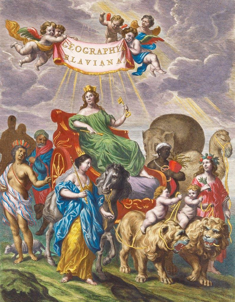
Cover: item 25
Terms and conditions: The condition of all books has been described. Each item may be assumed to be in good condition, unless otherwise stated. Dimensions are given height by width. All prices are net and do not include postage and packing. Invoices will be rendered in £ sterling. The title of goods does not pass to the purchaser until the invoice is paid in full.
Daniel Crouch Rare Books New York LLC PO Box 329 Larchmont NY 10538-2945, USA
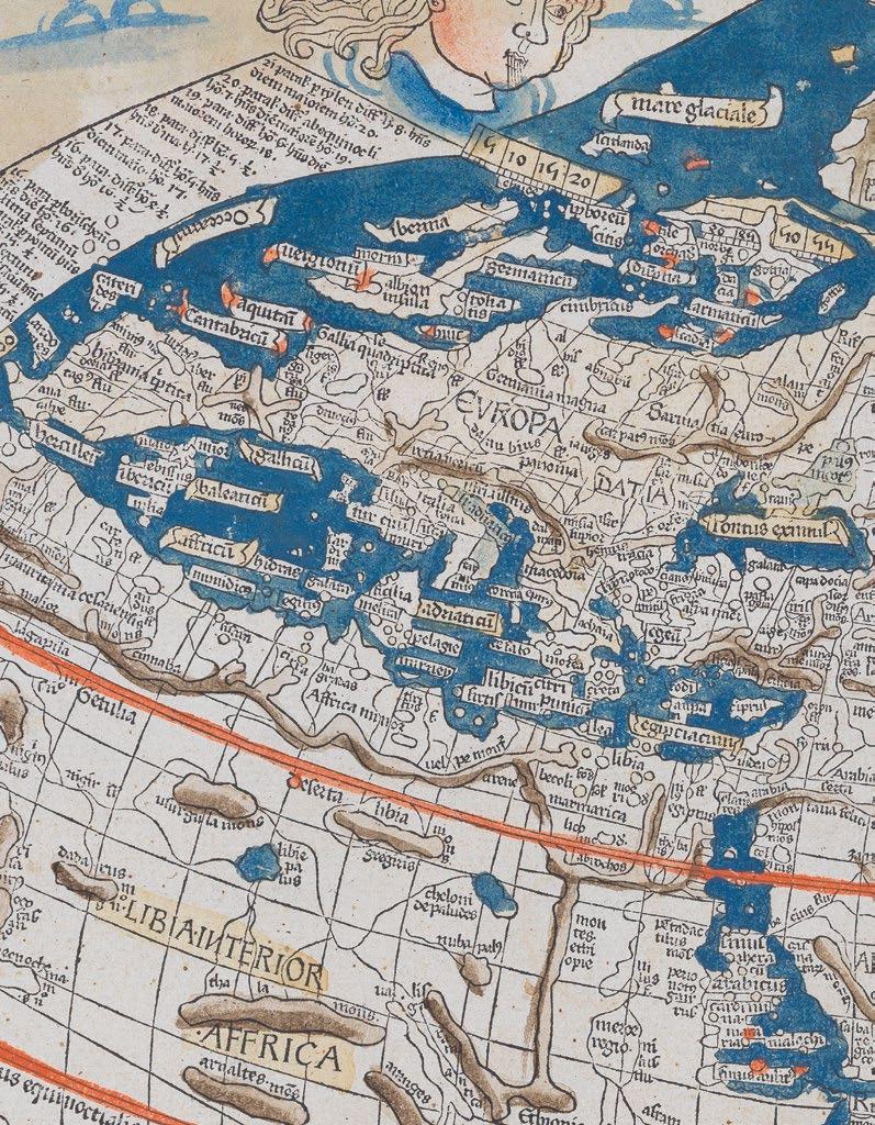
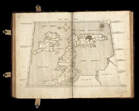
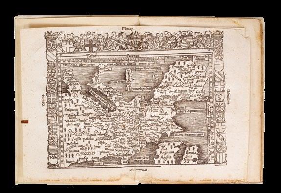
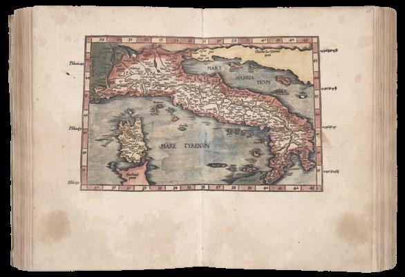
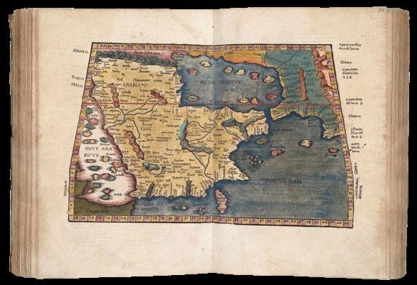
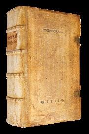
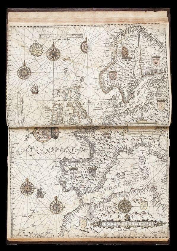
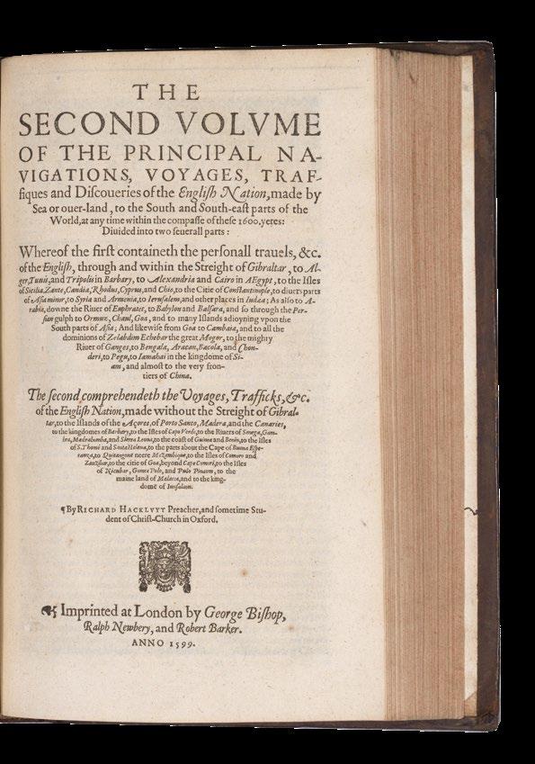
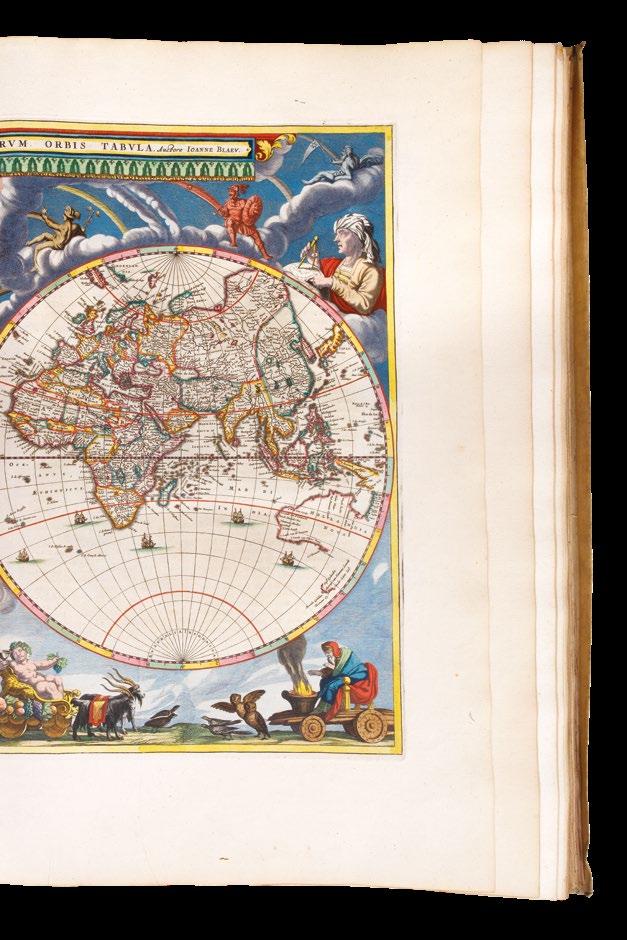
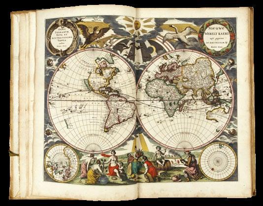
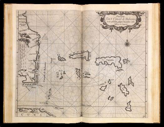
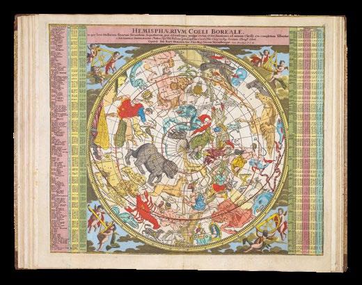
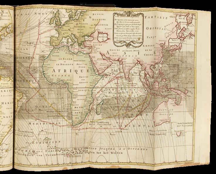
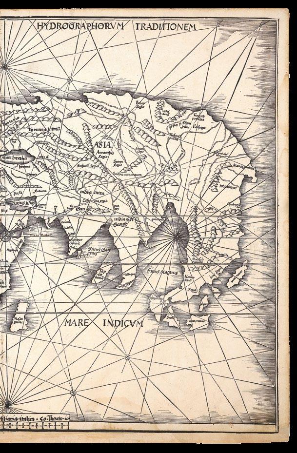
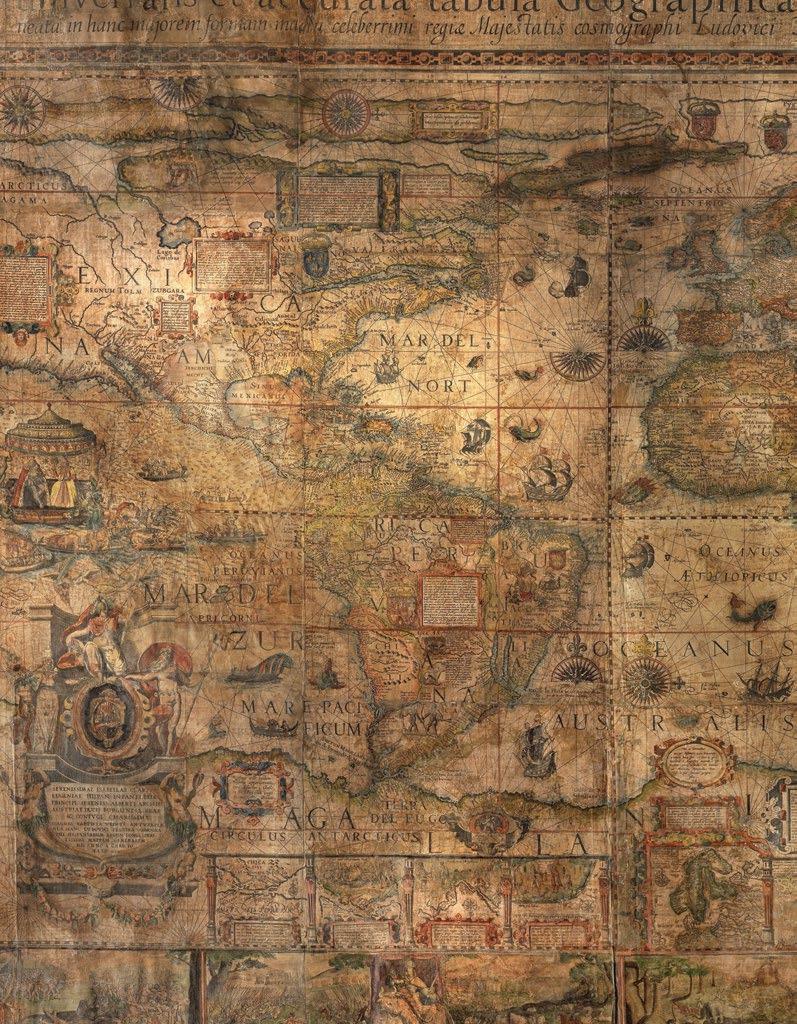
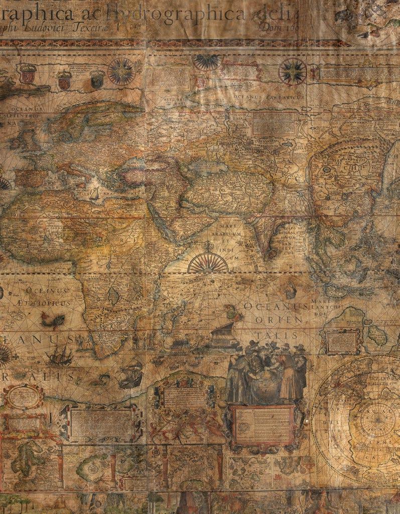
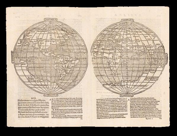
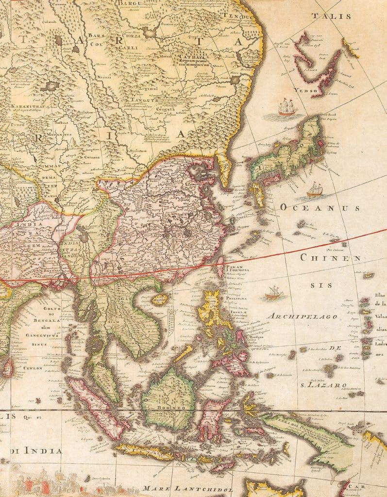
PTOLEMAEUS, Claudius; translated by ANGELUS, Jacobus, and edited by Nicolaus GERMANUS.
Cosmographia.
Publication Ulm, Lienhart Holle, 16 July 1482.
Description
Folio (428 by 310mm), 102 leaves, doublecolumn, 44 lines and headline, Gothic letter, 32 double-page woodcut maps with fine original hand-colour, 4 woodcut diagrams in the text, 2 large illuminated historiated initials, one showing Donnus Nicolaus presenting his book to Pope Paul II, the other of Ptolemy, 159 other woodcut initials coloured in red, green and ochre, paragraph marks and initial-strokes supplied in ochre, tear to d6, and repaired tear to the map ‘Tertia Africa’, some dampstaining and discolouration throughout, including spotting affecting the final three maps, skilful reinforcement to weakened lower page corners on maps, single leaf free endpaper bearing ownership inscription, re-cased in contemporary doeskin over clasped oak boards, joints reinforced with vellum waste, remnants of one clasp remaining.
[Bound after]: ‘Registrum’ from Johannes Reger’s 1486 edition of Ptolemy’s ‘Cosmographia’,decorated with 17 5- and 6-line manuscript initials in red and blue, 30 leaves bound in 6s (not 8s as is usually the case); 9 leaves in the ‘Registrum’ uncut, tear to d6.
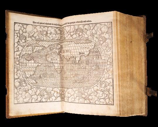
Projection, and the first map signed by its author
A fine example in a contemporary binding, here bound with Johannes Reger’s ‘Registrum’ made for his 1486 edition of the work.
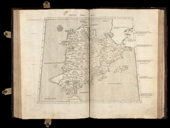
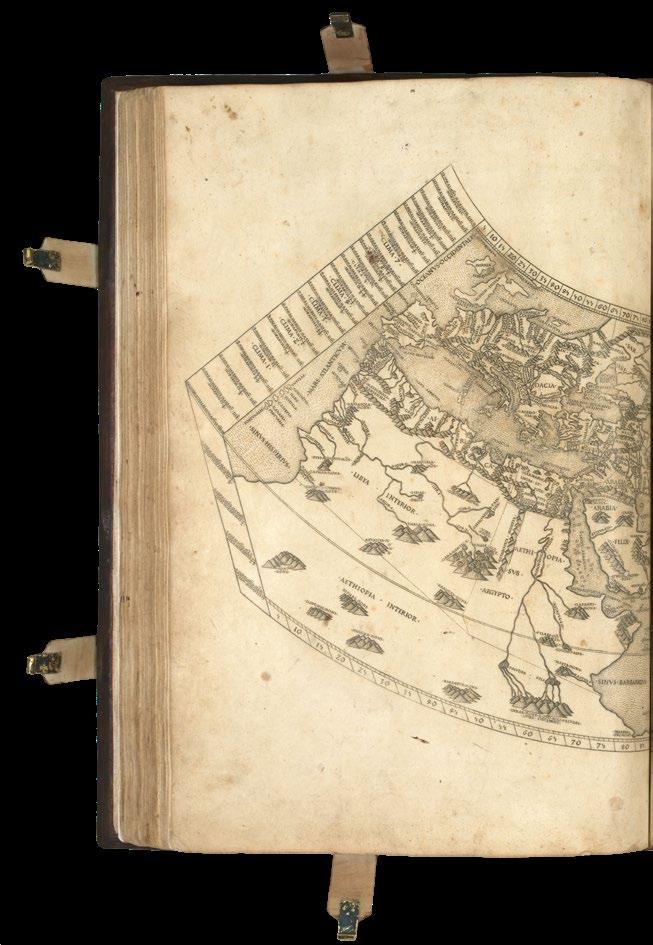
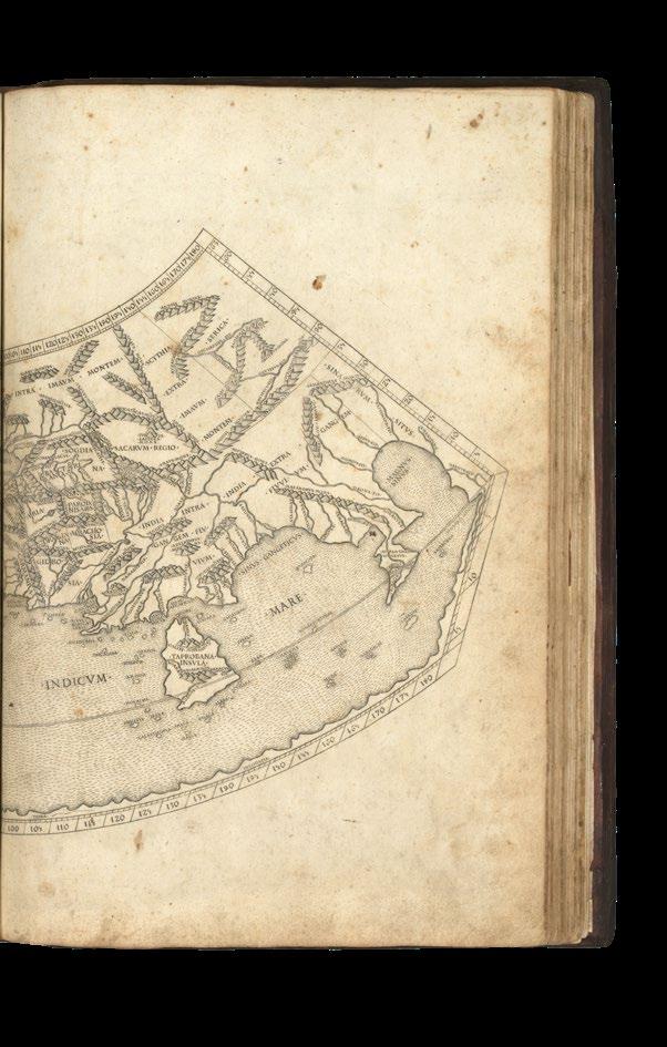
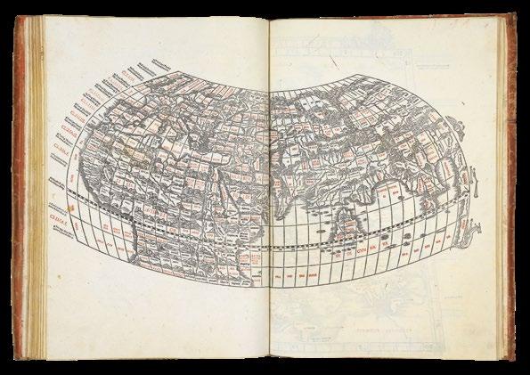
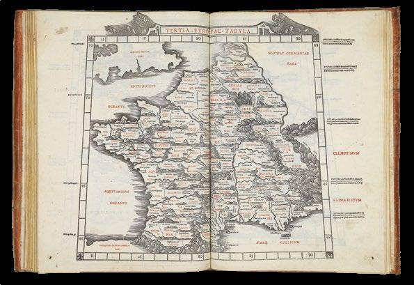
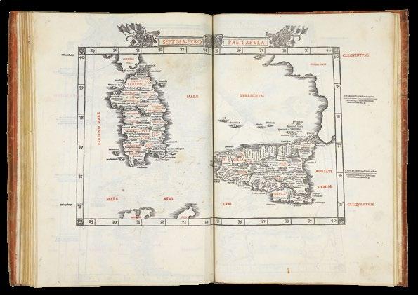
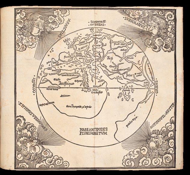
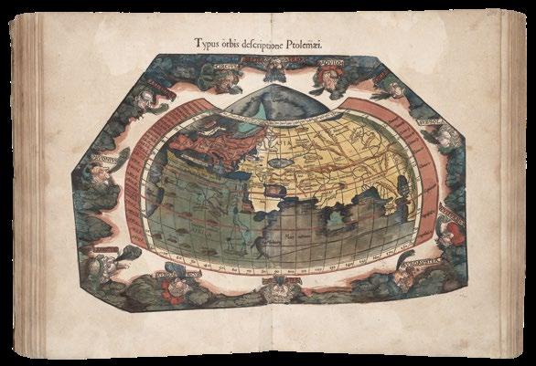
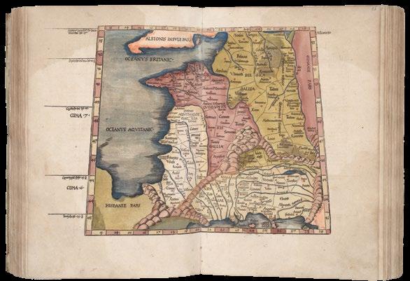
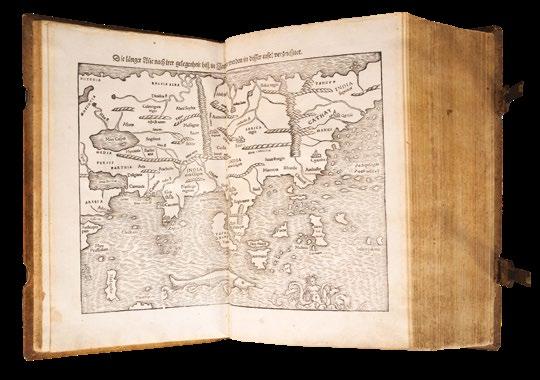
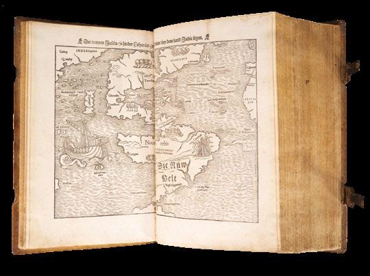
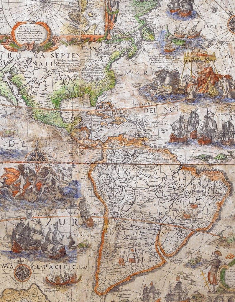
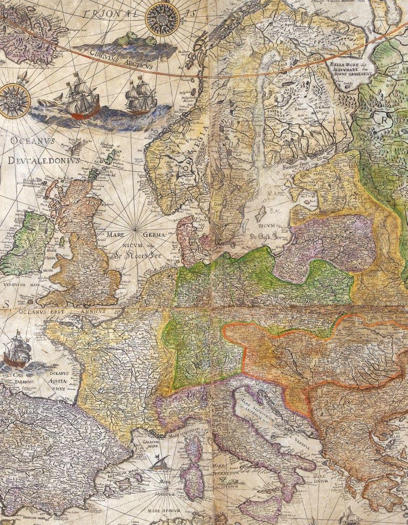
The text of Claudius Ptolemy’s (c.100-170AD) ‘Cosmographia’ was translated into Latin from the original Greek by Jacobus Angelus (c.13601411) and was first published, in Renaissance times, at Vicenza (1475), Bologna (1477) and Rome (1478). The sumptuous edition published at Ulm in 1482, however, far surpassed all earlier efforts and remains one of the most important publications in the history of cartography. This is the first redaction of the ‘Geographia’ to be printed outside Italy, the earliest atlas printed in Germany, the first to depart from the classical prototype to reflect post-antique discoveries, the first to be illustrated with woodcuts rather than engravings, and the first to contain hand-colored maps, the design and execution of which were ascribed to a named cartographer, and the first to incorporate the five modern maps by Nicolaus Germanus (c.1420-1490). Though printed outside Italy, the paper this magnificent atlas was printed on was imported from Italy, and payment made in part by complete copies of the finished atlas.
The maps
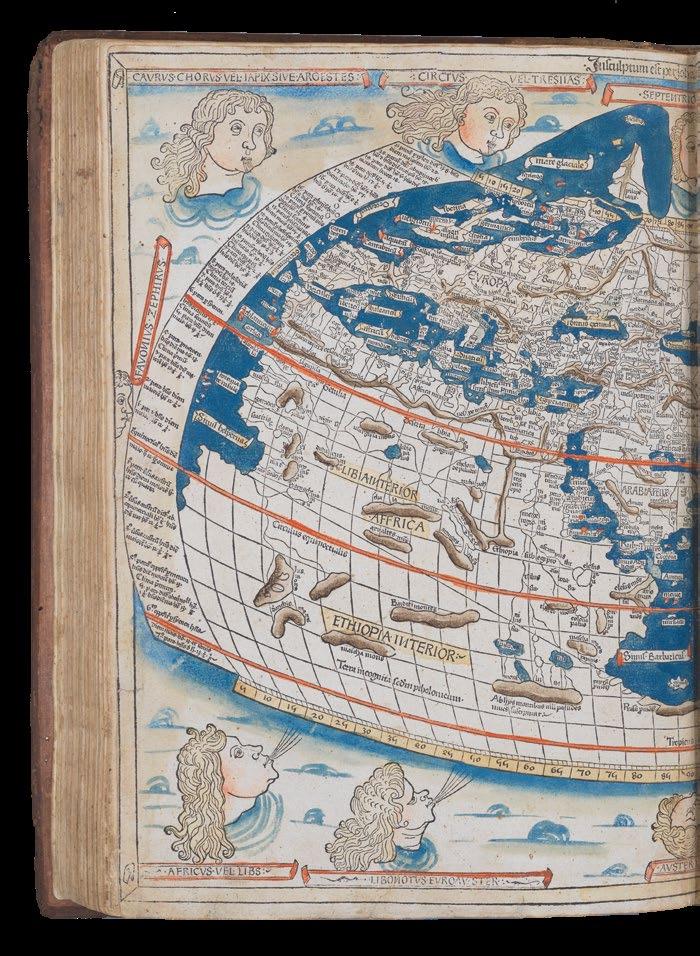
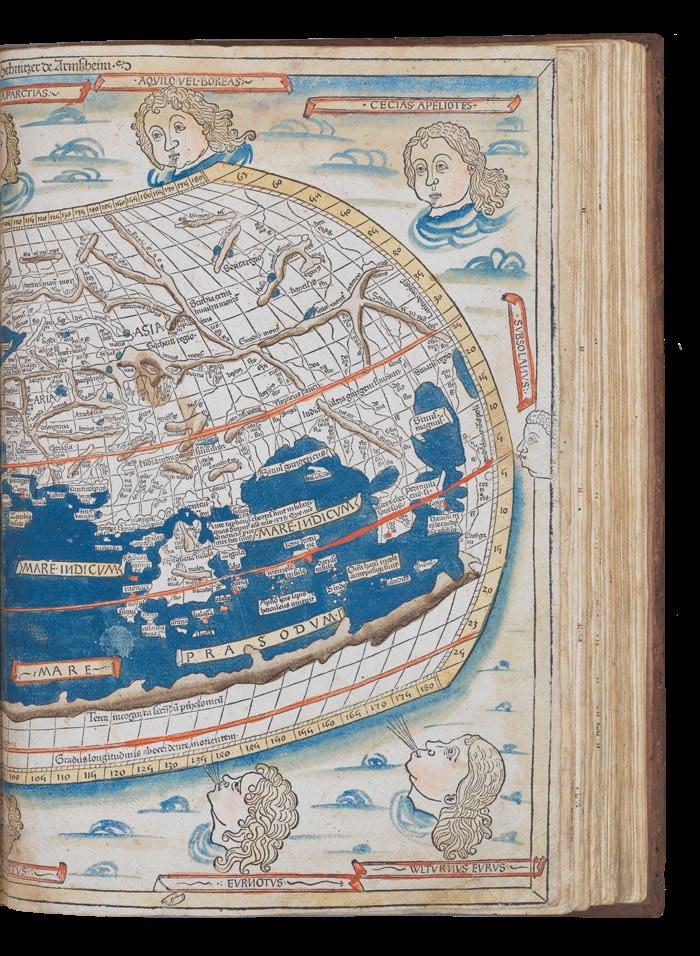
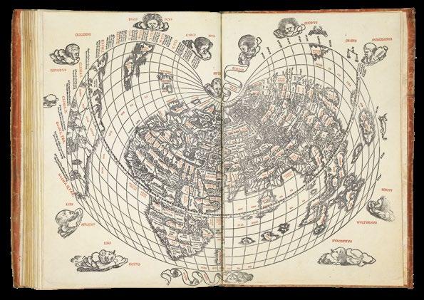
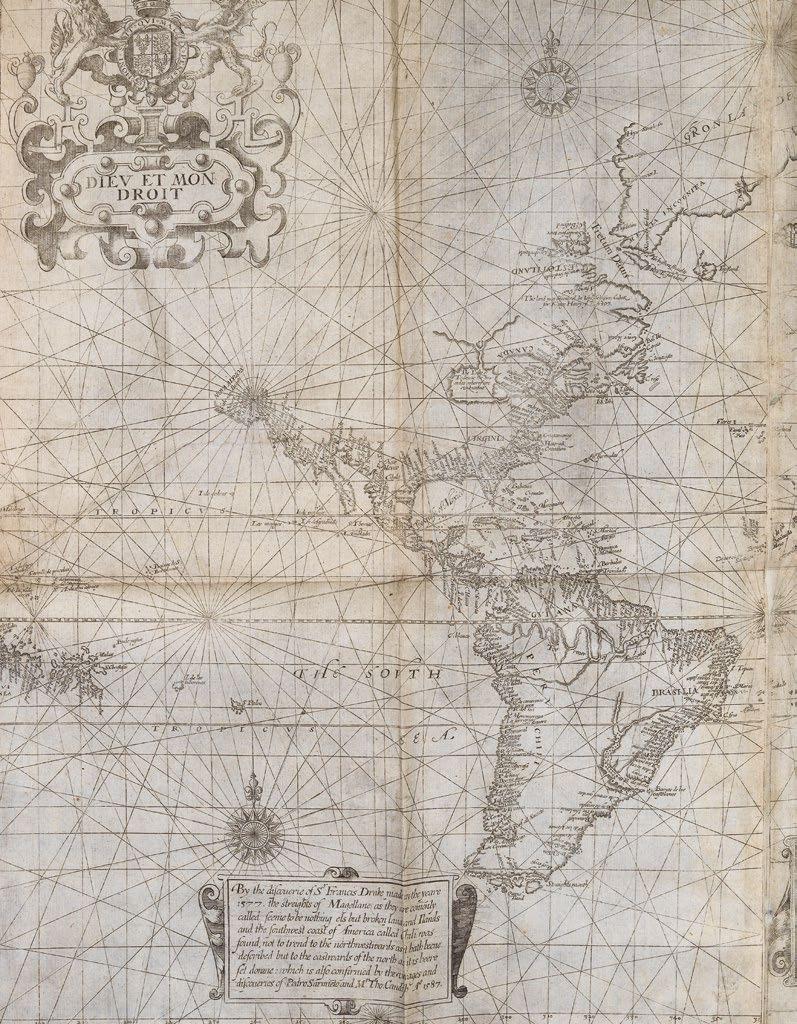
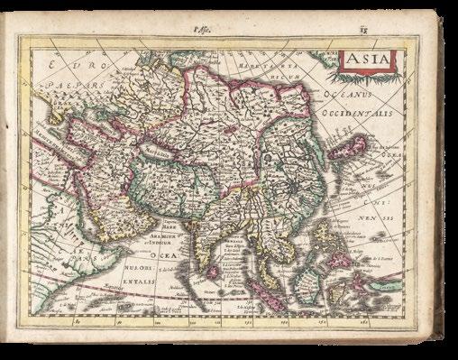
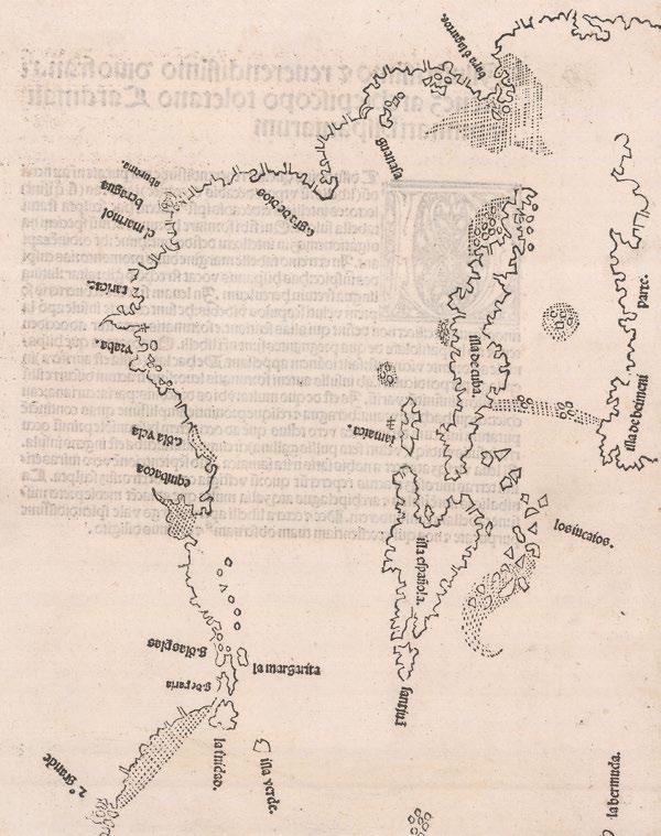
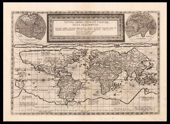
The 1482 edition is the first printed edition to contain the full complement of 32 maps, and its world map, extended to the northwest, is the first printed cartographical representation of Greenland, Iceland and the North Atlantic.
“The artist responsible for the woodcut maps identifies himself at the top of the world map as Johannes of Arnsheim, making it the earliest datable printed map to bear a signature” (Campbell p.137). He has incorporated as his sign a backwards N into the woodcut text on each map.
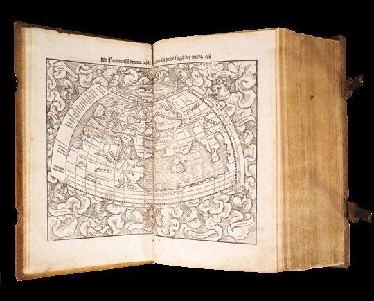
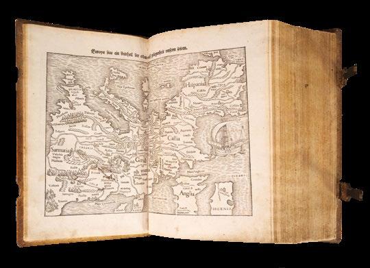
The Ulm edition, moreover, was the first to depart from the classical prototype by expanding the atlas to reflect post-antique discoveries about the size and shape of the earth. To the canonical twenty-seven Ptolemaic maps were added five “modern maps” of Spain, France, Italy, the Holy Land and northern Europe. The world map is of particular interest as it is the first to be signed, by Johannes Schnitzer (i.e. woodcutter) of Armszheim, who in trade mark fashion has reversed every capital N, and inadvertently provided two Tropics of Cancer. This map is the first to be based on Ptolemy’s second projection, in which both parallels and meridians are shown curved to convey the sphericity of the earth. Armszheim, furthermore, updated the Ptolemaic world picture by incorporating improvements that were probably based on a manuscript of the 1470s by Nicolaus Germanus (c.1420-1490), a Benedictine monk of Reichenbach Abbey in Bavaria, who is depicted in the first illuminated letter of the atlas presenting his book to the dedicatee Pope Paul II. One notable addition is a rudimentary depiction of Scandinavia to the north, within an extension of the map’s
Watermark:
Late fifteenth century Italian watermark of a flower with 7 petals throughout, with the exception of the front endpaper/ “initial blank”, which bears the watermark of an upper case letter “B” on a crowned shield. These were used by the le Bé family of Troyes, in this case “Ioane le Bé”. Three members of the Troyenne papermaking le Bé family bore the Christian name “Jean”: Jean I started his business in 1406. Jean II owned two paper mills around the 1470s, and Jean III lived in Troye in the first half of the 16th century. The le Bé family were accredited papermaker for the Université de Paris from 1520 onwards.
Dimensions 414 by 297mm (16.25 by 11.75 inches).
References
Camptell, T., Earliest Printed Maps, p. 179-210; Schreiber 5032; Skelton, R.A., Bibliographical note prefixed to the facsimile of the 1482 Ulm Ptolemy; P-J Troley, Mémoires historiques et critiques pour l’histoire de Troyes, t.2 p.636.
€1,450,000
top border. This is also the earliest printed map to show the northernmost reaches of the Atlantic Ocean. The world map embodies what is perhaps the most readily apparent feature of the Ulm Ptolemy: its beauty.
The text
“The text is the early Latin translation by Jacopo d’Angelo [Jacobus Angelus], and its maps are the reworking of the Ptolemaic corpus by the cartographer Donnus (Dominus) Nicolaus Germanus. Three recensions of Nicolaus’s reworkings have been distinguished: the first, drawn on a trapezoid projection reputedly devised by Nicolaus himself and, therefore, also known as the Donis (Donis = Dominus) projection; the second on a homeotheric projection and with three additional modern maps; and the third on the same projection with further revisions and two additional modern maps. The Ulm Ptolemy derives from the third recension, and thus represents Nicolaus’s most mature work” (Campbell).
Printing history
“That the stock of the 1482 edition was not exhausted by 1486 is indicated by the existence of a number of copies (some in early binding) containing the additional texts printed by Johannes Reger in the latter year for his own edition...” (Skelton) - The present work is just such a book.
“For Leinhart Holle, the handsome edition of the ‘Cosmographia’ which he printed at Ulm in 1482 was an unprofitable investment. Only one more book came from his press; and by 1484 he was out of business and gone from Ulm, and his stock of type, blocks, and printed sheets passed into the hands of Johann Reger, Ulm factor or agent (pro-visor) or Giusto de Albano, of Venice...
Reger lost little time in bringing the ‘Cosmographia’ back on the market. He compiled a gazeteer or geographical index to the text under the title ‘Registrum alphabeticum super octo libros Ptolemei’, to which he prefixed a ‘Nota ad inueniendum igitur regiones’; explaining its purpose and use; and he also obtained, or composed, an anonymous tract entitled ‘De locis ac mirabilibus mundi’... they were printed by Reger in 1486 and inserted into some unsold copies of the 1482 edition...
In the map Europa IV in the 1482 edition, Reger found the Ptolemaic name Chetaori, corresponding to his birthplace Kemnat in Bavaria; he introduced this into Ptolemy’s list of towns in bk. II ch. 10 [not present in this 1482 edition of the main text], and inserted in his “Registrum’ the entry: ‘Chemmat siue chetaori li 2 c 10 ta 4 e Hic iohannes reger duxit origine et ano etatis 32 compposuit hoc register in vlma anno domini 1486”. This is the evidence for Reger’s authorship of the ‘Registrum’, which is otherwise unsigned” (Skelton).
Cladius Ptolemaeus
Claudius Ptolemy was an Alexandrine Greek, and a dominant figure in both astronomy and geography for more than 1500 years. He compiled a mapmaker’s manual usually referred to simply as the ‘Geography’. He demonstrated how the globe could be projected on a plane surface, provided coordinates for over 8,000 places across his the Roman world, and expressed them in degrees of longitude and latitude. Now maps drawn by Ptolemy himself are known to survive, but maps compiled from his instructions as outlined in his ‘Geography’ were circulated from about 1300. This Ulm edition of Ptolemy’s ‘Geography’ is one of the earliest printed.
Provenance
1. Inscribed on front free endpaper “Donnait Le Sr. munery mon beaufrere [given by my brother-in-law Sr. Munery] anno 1672 Morel Senator” 2. Inscribed on d2 “Josephus Mattheus de Morel 1718, Franciseii de Morel”
This is probably André de Morel (Maurel) (1603-1690), Senator in the Parlement de Provence. Morel’s family began their social elevation under Charles d’Anjou (1446-1481) who was also King of Naples and Earl of Provence. It is said that the King put Pierre de Morel in his will and, at his death in 1481, he inherited a part of his library. The family served the French Crown as advisors and officers during wars in Northern Italy and Spain until Henri IV of France. Then in the late 1620’s André de Maurel became a prominent magistrate and member of Parliament of Provence. He ruled his office for 67 years and was known as Senator Morel. His second son, Joseph de Maurel (1658-1717) was Bishop of Saint PaulTrois-Chatêaux between Aix and Valence. His heir and nephew, François de Maurel, Captain in the ‘Regiment de Toulouse’ in 1719, inherited his belongings after his death.
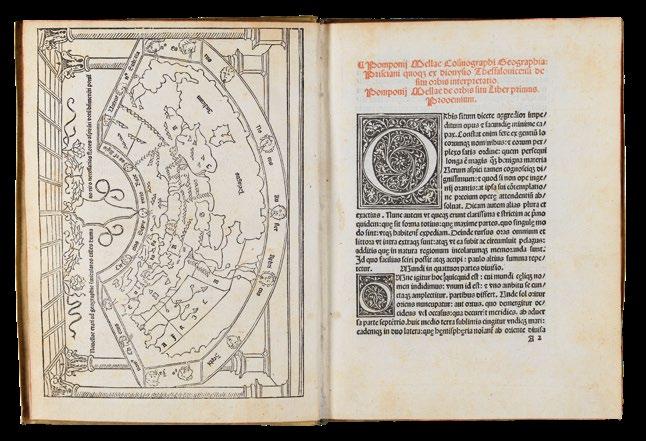
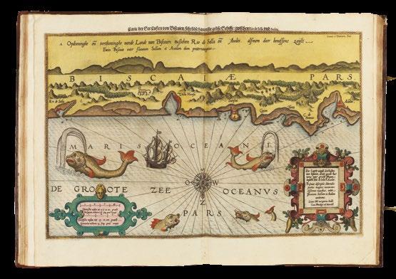
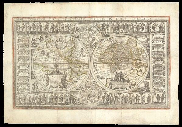
MELA, Pomponius
Pomponij Mellæ Cosmographi
Geographi Prisciani quo ex dionysio Thessalonicensi de situ orbis interpretatio. Pomponij Mellae de orbis situ Liber primus. Prooemium.
Two parts in one volume. Small 4to (190 by 145mm). Full-page woodcut map of the world on a Ptolemaic cone-shaped projection surrounded by an architectural border, first page of text with headline printed in red, two 11-line and five five-line floriated initials; early vellum with tan and black lettering pieces to spine.
“A well-deserved prayer is made for the young man who smells the requisite flowers along the winding paths of geography”
“The second woodcut map printed in Italy” (Campbell p.119). This was the first map to depict current Portuguese knowledge of the west coast of Africa which led, only six years later, to the rounding of the Cape of Good Hope. Campbell suggests that the edition’s printer, Erhard Ratdolt, may have been the mapmaker, since this and his T-O map of 1480 are the two earliest woodcut maps printed in Italy.
The title of the map nouellae etati ad geographie u(er)miculatos calles humano uiro necessarios flores aspira(n)ti uotu(m) b(e)n(e) mere(n) ti ponit(ur) (“A well-deserved prayer is made for the young man who smells the requisite flowers along the winding paths of geography” (trans.)).
Published in the same year as Lienhart Holle’s celebrated ‘Cosmographia’, Mela’s world map similarly includes additions to the Ptolemaic model. One of the more obvious changes is the addition of Scandinavia, and for the first time, the Orkney islands, off the northeast coast of Scotland, appear on a map. “In other respects, the map is unsophisticated, taking more care to identify wind heads than geographical features. Only the three continents and the Indian Ocean are named. The remaining lettering forms part of the Latin inscription above the map” (Campbell).
Mela’s map was cited with other early texts, including those by Macrobius, Ptolemy, Pliny and Aristotle, as part of the reading background of Christopher Columbus: “In its consideration of the oceans, this work would not have been particularly useful to Columbus, but in his view of the earth, Mela raised the probability that the southern hemisphere was inhabited, a novel idea for Christian believers in the biblical version of the Creation”(‘The Manifest’,James Ford Bell Library).
Pomponius Mela (fl.37-42CE), born in Spain and one of the earliest Roman geographers, lived during the reign of Emperor Claudius. His ‘Cosmographia’ was circulated in manuscript, and from the early-fifteenth century, sometimes with a map. It was first printed in 1471, without a map. His was the “only formal geographical treatise in classical Latin” (Campbell). The ‘Cosmographia’ expressed concepts that were similar to those of the leading Greek geographers, yet the map which accompanies this 1482 edition expresses the current school of thought, rather than Mela’s own.
According to Wilson, the Mela map was the model for Hartmann Schedel’s world map in the ‘Nuremberg Chronicle’. Within its novel architectural framework, the map is drawn on a conical projection, a modification of the Ptolemaic type. The text, a motto, the Latin names of the winds represented by ‘wind-heads’ surrounding the map, and the legends are provided in letterpress. The map shows Europe, Asia (including Ceylon, that is drawn with a bay shaped like a keyhole), and a large part of Africa. Notable is the depiction of the Nile, with its sources in the mountains south of two lakes, which correspond in their location to those today called Lakes Albert and Victoria Nyanza. The mountains are also depicted on other maps and are called the Mountains of the Moon”.
PTOLEMAEUS,
Claudius
Cosmographia.
Publication
Rome, Petri de Turre, 1490.
Description
Folio (425 by 282mm), loose endpaper/ initial blank on different paper, minor wormholes to first two gatherings, occasional minor staining to margins not affecting text, very occasional manuscript annotations in faded ink, 27 double-page engraved maps, minor staining to world map, some loss to right edge of ‘Quinta Asia Tabula’ not affecting printed area, ‘Sexta Asia Tabula’ with small closed tear to title, small open tear to right edge and some brown staining, some minor brown staining to ‘Decima Asia Tabula’, minor wormholes to final two gatherings. Contemporary calf decorated in blind with intricate roll tool borders enclosing central diamond with woven rope motif, clasps with cross straps replaced, some areas of repair including triangular area c.50-60mm to upper cover and small area to lower left hand corner of lower cover, early paper label with manuscript lettering in iron gall ink.
Collation:
A8 (first leaf blank) B-C8, D6 (second leaf incorrectly signed D3), E6, a10 (first leaf blank), b-g8, h3 (lacking final blank leaf), 27 engraved maps, 2a8 (2a1r blank, 2a1v registrum super tractum de tribus orbis partibus, 2a2r-2c5r de locis ac mirabilibus mundi et primo de tribus orbis partibus), 2b8, 2c6 (lacking final blank leaf, 2c5r colophon: Hoc opus Ptholomei memorabile quidem et insigne exactissima diligentia castigatum iucondo quodam caractere impressum fuit et completum Rome anno a nativitate Domini .M.CCCC.LXXXX die .IV. Novembris. arte ac impensis Petri de Turre, 2c5v blank).
References
BMC IV, 133; BSB-Ink P-861; Goff P-1086; HC 13541; Nordenskiöld 7; Sabin 66474; Shirley 4; Scammell, The World Encompassed 40; Tooley, Landmarks of Mapmaking.
€365,000
Ptolemy’s first projection, with the “finest Ptolemaic plates produced until Gerard Mercator”
The “handsome” second Rome edition of Ptolemy’s ‘Geographia’ (Scammell).
The plates for the Rome editions of Ptolemy were several years in the making, and they are considered to be “the finest Ptolemaic plates produced until Gerard Mercator engraved his classical world atlas” a century later (Shirley). They were produced by two German printers, Conrad Sweynheym and Arnold Buckinck, and “it is believed that Sweynheym was the one who first thought of applying the very new art of copper-engraving to the printing of maps, and he might have taken a hand in the actual engraving of them himself” (Scammell). The first edition was printed in 1478, and the present edition was printed 12 years later from the same plates.
While the Bologna edition of 1477 was the first atlas and edition of Ptolemy to use copperplate maps, the Rome edition is generally regarded as superior for its clear captions, accurate projections and overall design. It includes more geographical details, including in particular names in Arabia. Unusually, the seas are pock-marked. The early Italian Ptolemys, particularly the Rome editions, are “superb testimonials of Italian craftsmanship without the picturesque but unscientific monsters of the medieval maps or the addition of the adventitious decoration of later work, relying for their beauty solely on the delicacy of their execution and the fineness of the material employed” (Tooley). As Tooley observes, the maps in the atlas have no external border decorations or co-ordinate lines, relying instead on the clarity of the engraving.
PTOLEMAEUS, Claudius; Bernadus SYLVANUS
Liber geographiae cum tabulis et universali figura et cum additione locorum quae a recentiorbus reperta sunt.
Publication Venice, Jacobus Pentius de Lencho, 1511.
Description
Folio atlas (425 by 292mm), bookplate to verso of initial blank leaf, title in red with manuscript ownership inscription, poem on verso printed in red and black, 6pp preliminary text printed in red and black, 115pp text printed in red and black with four woodcut and letterpress diagrammatic illustrations, manuscript notes throughout in margins of text in same hand as ownership inscription, small area of abrasion damage to colophon, infilled with ink facsimile, 28 woodcut maps printed in red and black (each double-page with all but the final world map in two sections on facing pages), sixteenth century red vellum, remnants of old ties, japp fore-edges.
Collation:
[4]; A8, B-H6 (first leaf of G unsigned), I8 (first leaf unsigned), 28 maps.
References
Jerry Brotton, A History of the World in Twelve Maps (London: Penguin, 2012); Patrick Gautier Dalche, ‘The Reception of Ptolemy’s Geography’ in David Woodward (ed.), The History of Cartography, Volume 3 Part 1: Cartography in the European Renaissance (Chicago: University of Chicago Press, 2007); Nordenskiöld Collection 2:204; Phillips, Atlases 358; Sabin 66477; Sander 5979; Shirley, Mapping of the World, 32; David Woodward, ‘Techniques of Map Engravings, Printing and Coloring in the European Renaissance’ in David Woodward (ed.), The History of Cartography, Volume 3 Part 1: Cartography in the European Renaissance (Chicago: University of Chicago Press, 2007).
€180,000
The first atlas wholly printed in colours, incorporating the first printed map to indicate Japan
A very fine example of the Venetian edition of Ptolemy’s ‘Geographia’. This is the first illustrated edition of Ptolemy’s work in which an attempt was made to update the information given on the maps, and the only Italian edition of Ptolemy to feature woodcut maps.
It is also one of the earliest examples of two-colour printing in cartography with the major regional names printed in red, others in black, using inset type. Woodward suggests that the dual-colour printing style is done to mimic contemporary portolan chars, which used black and red to distinguish toponyms of various importance. The text in the book says that it used the maps of navigators to update Ptolemy’s original work, and the influence may also have extended to the aesthetic (Woodward).
Sylvanus had already produced an edition of Ptolemy in Naples in 1490, but this was to be based on different principles. He explains in a preliminary note that Ptolemy’s work must be updated, and adds that as Ptolemy himself used the work of navigators, so will he. Sylvanus was trying to tread a delicate line between critics of Ptolemy’s work and those who appreciated the framework provided by the classical geographer (Dalche).
The atlas includes two world maps, one drawn to Ptolemy’s specifications and the other using contemporary geographical knowledge. The modern cordiform world map is only the second map in a Ptolemaic atlas to show America, and the first western printed map to indicate Japan. Sylvanus uses a cordiform map projection, a style developed through the Renaissance to symbolise the link between inner emotions and the external world (Brotton). Sylvanus’ method was subsequently adapted by Apianus and Vavassore. In this projection, the degrees on the central meridian were in correct proportion to those of the parallels. Whereas every other map in the atlas is printed on the reverse of other maps or texts, this is blank on the reverse. This map was Sylvanus’ attempt to update the picture of the world presented by Ptolemy.
The Americas are shown in three unconnected parts: “terra laboratorum”, “terrae Sancta Crucis” (South America) and “terra cube”. “Terra laboratorum”, or North America was supposedly named after the labourer who saw it first, according to an inscription on Wolfenbüttel’s 1534 world map. The projection used distorts the coastline of South America almost unrecognisably; the words “canibalum romon” appear in the north, a product of common contemporary belief about native cannibalism.
The outline of eastern Asia follows Ptolemy and retains the “Tiger Leg” used by Waldseemüller and Contarini and the Ptolemaic name “Catigara”. Japan appears, named “Zampagu ins”, and shown correctly as an island for the first time. A previous depiction by Ruysch identified Japan with one of the islands discovered by the Spanish in the Caribbean. Asia’s coastline is left open to the east, as is the western coast of the Americas, allowing for the possibility that they were contiguous. The map is labelled in the style of Ptolemy; rivers and mountain ranged are shown and named, but very few place names appear.The entire continent of Europe contains only “magna Germa”, “Italia” and “dalma”.
An earlier owner, Francisco de Chiapanis, has made extensive manuscript notes in the preliminary text of the atlas. He seems to have been particularly interested in the mathematical basis of Ptolemy’s work, with diagrams and calculations working out ideas in the text. Francisco also approves of the editor’s tone in the book, noting “Modestia Auctoris” next to a line apologising for the author’s inexperience.
LA SALE,
Antoine de
La Salade, nouvelleme[n]t imprimee laquelle fait mension de tous les pays du monde Et du pays de la belle Sybille avec la figure pour aller au mont de la belle Sibille Et aussi la figure de la Mer & de la terre et plusieurs belles remonstrances.
Publication [Paris, veuve de Michel Le Noir, 1521].
Description
Quarto (254 by 180mm), (4 ff.), lxiii ff. lxxiii, numerous illustrations within text, three folding plates, several leaves (mainly the last nine) with loss to upper corner, skilfully repaired in facsimile, some stains and wormholes on the last leaves, contemporary full panelled calf, blind fillet borders, with gilt foliate device to corner and centre, spine in six compartments separated by raised bands. Collation: [sig. ?4 a-d6 e-f4 g6 h-i4 k6 l-n4]
References
Bechtel, L.54-L55; Brunet, III, 854; Shirley [World], 50; Tchйmerzine, IV, pp. 59-61.
€90,000
An eclectic miscellany of moral, didactic, and chivalric treatises, ‘La Salade’ also contains the earliest printed map to name the Antipodes.
Prepared by Antoine de La Sale for his pupil, Jean II of Anjou, Duke of Lorraine, the title, ‘La Salade’, is not only a pun on de La Sale’s name, but also reflects the varied composition of the work - as de La Sale notes in the introduction, “in the salad are several good herbs” (trans.). The contents cover a variety of subjects edifying for a fledgling duke: a treatise on the eight virtues useful to a prince, stories and stratagems from ancient authors like Valerius Maximus and Frontinus, accounts of de La Sale’s own adventures in Sicily, geography, and the ceremonies and ordinances of Philip IV of France. ‘La Salade’ is also one of the earliest European texts to provide information about Iceland and Greenland, previously “unknown to our astrologers due to their long harsh winters” (trans.).
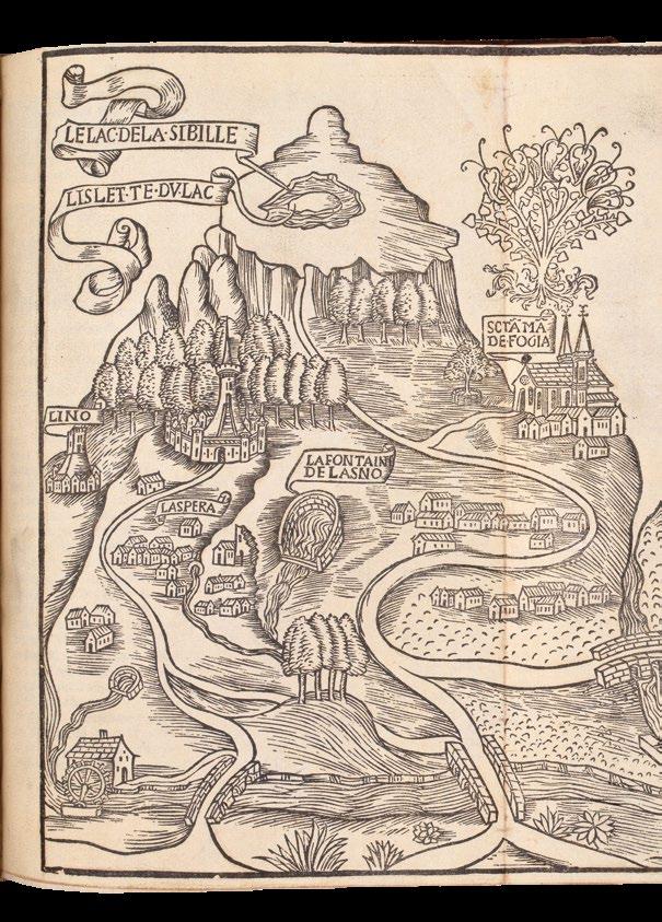
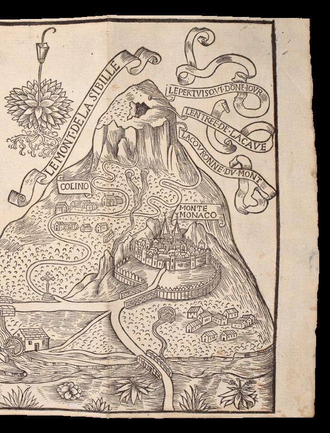
The text is illustrated throughout and includes folding plates that depict “Le Mont de la Sibille” and the genealogical tree of the House of Aragon – as well as a map of the world.
The map
The world map is a “curious ensemble” (Shirley), combining ideas from the classical world (in particular, those of Pomponius Mela) with medieval and more contemporary concepts. It is also the earliest printed map to name the Antipodes. England and Scotland are shown separated by a strait, as is the case also in early portolan charts, while Africa appears as a peninsula. Present in the south is the “Regio Patalis”, a name drawn from Pliny, which hints at the presence of Australia.
Antoine de La Sale (c.1386-c.1461)
Born the illegitimate son of Bernard de La Sale, French mercenary captain turned Tard-Venus bandit, de La Sale entered the court of the dukes of Anjou in 1402. In the 50 years that he spent in their service, he moved through the ranks, from page to squire, to soldier, to administrator, eventually taking up a position as “gouverneur”, that is tutor and mentor, to Jean II of Anjou, Duke of Lorraine, for whom he wrote ‘La Salade’. In 1448, he became “gouverneur” to the sons of Louis de Luxembourg, Count of St Pol, for whom he wrote a book similar to ‘La Salade’, known as ‘La Sale’. Among his other works are a treatise on the organization of tournaments, a “consolatio” to Catherine de Neufville, on the death of her son, and ‘Le Petit Jehan de Saintré’, a light and witty chivalric romance.
Rare: we are only aware of one example of the first edition appearing at auction in the last 40 years.
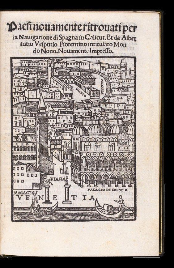
MONTALBODDO, Antonio Fracanzano da
Paesi nouamente ritrovati per la Navigatione di Spagna in Calicut Et da Albertutio Vesputio Fiorentino Intitulato Mondo Nouo. Nouamente Impresso.
Publication
Stampata in Venetia, per Zorzo de Rusconi Millanese. Nel.M.D.XXI.adi.xy.de Febraro, 1521.
Description Octavo (150 by 100mm). Title-page with woodcut bird’s-eye view of Venice, woodcut diagrams in the text, woodcut initials; twentieth century full green crushed morocco, gilt, all edges gilt.
Collation: 124 leaves; A4, b-q8.
References
Borba de Moraes II, 70; Church 41; Essling 1954; Fumagalli & Amat di S. Filippo 1003; Gasparoni, ‘Gli annali di Giorgio Rusconi (1500–1522’, 2009; Harrisse 90 and Add. 52; JCB I, 68; Penrose 277; Sander 4875; Sabin 50053.
€100,000
With
an early
bird’s-eye view of Venice
The earliest surviving printed collection of narratives about the voyages to America is a little booklet of sixteen folios, published by Albertino Vercellese da Lisona at Venice in 1504, with the title: ‘Libretto de tutta la navigatione de re de Sfagna de le isole et terreni novamente ritrovati’, known in only two examples, at the Marciana Library in Venice and the John Carter Brown Library in Rhode Island.
The ‘Libretto...’ was then included by Antonio Montalboddo, along with additional accounts of Portuguese voyages to Africa and India, in his ‘Paesi novamente retrovati...’. Almost immediately, that work was translated into Latin, by the Milanese monk Arcangelo Madrignano, after which it quickly became “the most important vehicle for the dissemination throughout Renaissance Europe of the news of the great discoveries both in the east and the west” (PMM).
The current version of the ‘Paeis’, in Italian, was first printed in Venice by Giorgio Rusconi (1500-1521) in 1517, with the first appearance of the bird’s-eye view of Venice on the title-page, which would be reprinted several times over the next, more than, one hundred years in editions of Niccolò da Poggibonsi’s, ‘Viaggio da Venetia’, first published in Venice by Rusconi’s frequent collaborator, Niccolo Zoppino from 1518.
The work includes accounts of the voyages of: the 1456 voyages of Alvise de Cadamosto in Ethiopia and along the West African coast; Pedro de Sintra’s expedition along the west coast of Africa as far as Sierra Leone in 1462; Vasco da Gama’s epochal voyage to Africa and India (1497-99), which “opened the way for the maritime invasion of the east by Europe” (PMM), supplied by letters from Venetian spies in Portugal; and Pedro Alvares Cabral’s discovery of the Brazilian, Guianaian and Venezuelan coasts in 1500, and of the voyage on to India; an account of Columbus’s first three voyages (1492-1500), undoubtedly based on Peter Martyr’s ‘Libretto de tutta la navigatione de Re de Spagna de le isole et terreni novamente trovati’; as well as narratives of the expeditions of Alonso Niño and Vicente Yañez Pinzon along the northern coast of South America; Vespucci’s letter to Lorenzo de’ Medici describing his third voyage in 1501-1502; and a compilation of information derived from several sources concerning the Portuguese discoveries in Brazil and the East.
Montalboddo’s collected voyages, called by Henry Harrisse “the most important collection of voyages”, and asserted by Boies Penrose that “for news value as regards both the Orient and America, no other book printed in the sixteenth century could hold a candle to it”, was the forerunner of the later compilations of Grynaeus and Huttich, Ramusio, Eden, Hakluyt, the De Brys, and Hulsius, “an auspicious beginning to the fascinating literature of the great age of discovery” (Lilly Library online).
The printer
Giorgio Rusconi, self-professed Milanese, was a profuse printer of more than 200 works, in Venice from 1500–1522. Between 1515 and 1518, he collaborated with Niccolo Zoppino, who published the ‘Viaggio da Venetia’ (from 1518), which reprints the woodcut image of Venice on the title-page of this edition of Montalboddo (from 1517).
Rusconi “seems to have begun his Venetian career in the workshop of Manfredo Bonelli, who had been printing since 1491. The names of the two men appear together in four editions of the year 1500, while Rusconi alone signs two editions in the same year. It is probable that Bonelli taught Rusconi the art of printing” (Gasperoni). After his death the business was continued by his sons Giovanni Francesco and Giovanni Antonio, and his widow Elisabetta.
Provenance
1. With the “Duplicate released” ink library stamp of the Lilly Library, Indiana University;
2. With Arthur Lauria, Paris, November 1967, sold to; Gregory S. Javitch (1898-1980), of Montreal, renowned bibliophile with an important collection of very fine books relating to Native Americans; his collection Jesuit Relations is housed at the University of Alberta. A Russian-born, Canadian leader in the land reclamation sector in Ontario, Javitch formed an important collection of 2500 items that he called “Peoples of the New World”, encompassing both North and South America, which was acquired by the Bruce Peel Special Collections at the University of Alberta. It was considered the finest such private collection in Canada at the time and formed the cornerstone of the library’s special collections. The present volume remained in Javitch’s private collection.
MÜNSTER, Sebastian
Erklerung des newen instruments der Sunnen Nach allen seinen Scheyben und Circkeln.
Publication
Oppenheim, Jakob Kobel, 1528.
Description
Quarto (215 x 150 mm). Letterpress titlepage, woodcut map and three illustrations, floriated initials abundantly throughout; later grey paper boards, title printed on spine, bottom margins untrimmed, later endpapers, small tears in final two leaves skilfully restored, very small loss to text in upper left corner of D4.
References
Burmeister Münster, 31; Karrow 58/BI; Woodward, The History of Cartography, p1211.
€22,000
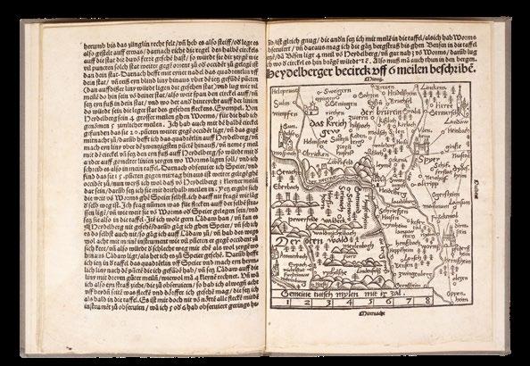
The standardization of cartography
An era-defining landmark in cartographic ambition.
Previously, cartography had been a patchwork affair. Whether through collaboration or plagiarism, multiple sources, measurements, and methods were used to create maps. Münster’s ‘Instrument of the Suns’ changed the game. He called on leading cartographers - including Apianus, Tansterrer, and Glareanus - to submit maps of their duchies created using a standardized method. From Austria to Switzerland, Bavaria to Franconia, Münster’s ambition was to create the first accurate map of the German Empire.
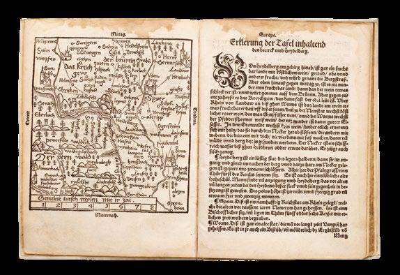
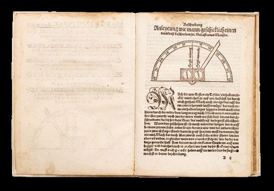
The pamphlet opens with a practical guide to fashioning an ‘instrument of the sun’. This was intended for the surveying of topographical and horological data needed to create an accurate map. The bulk of the text describes its construction and use, and is illustrated with a woodcut of the semi-circular tool. The project is concluded with a near-full-page map of Heidelberg, surveyed by Münster himself to instantiate his method.
Having thus demonstrated the principles of scientific map-making, Münster employs energetic rhetoric to plead for co-operation in producing what would be the first accurate cartographic depiction of the Germanspeaking lands.
“Please, O dear Germans, help us to raise this common German fatherland to a just and honourable end. To bring its hidden ornamentation to light, so that you and I will gain eternal praise and memory among our descendants”. Driving home the nationalist fervour, Münster promises “The strong German nation will not let you down in any way”.
Several cartographers rose to the challenge, and the fruits of this labour culminated in Münster’s 1544 Cosmographia - the most widelyread general atlas of the sixteenth century. It drew on 120 reports submitted to Münster, using the method detailed in the present pamphlet. Such systematic co-operation constitutes a landmark in the history of cartography - Münster had stamped scientific rigour into the map-making world.
Rare. This edition is not held in any institution outside of Europe; later editions are owned by Harvard (1529) and Minnesota (1534).
MÜNSTER,
Sebastian
Mappa Europae, Eygentlich für gebildet aussgelegt und beschriebenn.
Publication
Frankfurt, Christian Egenolph, 1536.
Description
Quarto (200 by 150mm). Title-page woodcut vignette, two double-page woodcut maps at the rear, one bound upside-down, one full-page map, illustrated profusely throughout with woodcuts, including two surveying instruments hand-coloured in part; modern vellum, title inked to spine, bookbinder’s ticket on the front pastedown, top edge dyed blue, some damp stains in margins throughout, small tear to bottom margin at D2-3, not affecting text, small early repairs to heads of both double-page maps.
References
Bagrow, ‘Carta Itineraria Europe Martini Ilacomili, 1511’, Imago Mundi XI, pp14950; Hantzsch, pp39-41, 75-76, 148 (note 63); I Graesse IV, 622;Karrow, Mapmakers of the Sixteenth Centuries, 58/P; Woodward, The History of Cartography, p1211; VD16 M6677.
€75,000
First edition of Münster’s first geographical work, with his first ‘inverted’ map
Extremely rare first edition of Münster’s first geographical work, including the earliest acquirable map of Europe oriented to the south.
Declared “the later Cosmographia in microcosm” (Karrow), this very early pamphlet is a lay practical guide on map making, reading, and navigation across Europe. It is the first appearance of Münster’s ‘inverted’ map - an innovation so radical that the binder instinctively turned the double-page map of Europe ‘the right way up’ in error. This innovation in orientation was beneficial for both cartographers and travellers, as coastlines and journeys could be plotted simply with a sundial or compass. Such ease of navigation cemented this ‘inversion’ as the first ‘modern’ orientation.
Although Erhard Etzlaub, a Nuremberg chronicler, was the first to use this southern orientation in his 1499 map of Rome, it is more likely that Münster took inspiration from Martin Waldseemuller’s later 1511 world map - as evidenced by the ten sketches of it found in Münster’s schoolbook.
Therefore, whilst not originating from Münster directly, he was the first to map Europe with a southern orientation, and his later adoption of this in the Geographia (1540) and Cosmographia (1544) set a firm cartographical standard.
A second striking feature of this sixteenth-century German cartographic style was a focus on involving the audience. Reading maps was recommended in tandem with the use of precision instruments, which is exemplified in the present work by the repeated sundial woodcut. Münster also details how such a sundial can be made and used, providing a cheaper alternative to the magnetic surveying instruments of learned cartographers. Furthermore, Münster instructs readers on: how to determine latitude, distances between cities, navigation by sun compass, and how a reader can create their own map.
By publishing in the vernacular, cutting-edge cartography could be recognised by a lay audience. ‘Mappa Europae’ was intended as a popular alternative to Münster’s earlier ‘Germaniae descriptio’ (1530), written in academic Latin. “The Mappa should thus be understood as a prospectus designed to encourage general interest in cosmography, no more the domain of a limited number of learned people... but now aimed at the masses and townsfolk” (Burmeister).
After this practical guidance, Münster describes key cities, states, and countries in Europe. His guide-book style descriptions point towards the development of commercial travel in the sixteenth century; whilst his two regional maps of Heidelberg and Basel were closer to home, Münster includes woodcut vignettes to accompany places as exotic as Tartary and Turkey. Holland is described as having strong men with good manners, who are devout and loyal. England, on the other hand, had beautiful women but a vindictive, superstitious, and cruel people. Münster makes note of which countries contain wolves, poisonous animals, and vineyards, which lends an entertaining insight into the concerns of the Discovery Period. Rare: we have traced only one North American example of the 1536 edition (NYPL), lacking both double-page maps. Two examples of the second edition are held in Harvard and Yale, although the former lacks the maps. No complete example has come up at auction in the last fifty years.
PICCOLOMINI, Alessandro
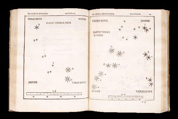
De la Sfera del Mondo. [and] De Le Stelle Fisse.
Publication Venice, 1540.
Description
Quarto (215 by 155mm), 47 full-page woodcut star maps, minor dampstaining to lower margin of a few tables, contemporary ownership inscription to title and last page, contemporary vellum.
References
Thomas Hockey et al, Biographical Encyclopedia of Astronomers, (New York: Springer, 2007), 904-5; Owen Gingerich, Piccolomini’s star atlas”, Sky and Telescope 62 (1981): 532-4; John North, Cosmos: An Illustrated History of Astronomy and Cosmology (Chicago: University of Chicago Press, 2008), 277; R. Suter, “The Scientific Work of Alessandro Piccolomini,” Isis 60 (1969): 210-22; Deborah Warner, The Sky Explored: Celestial Cartography 15001800, (New York: Liss, 1979), 200.
€14,500
The first printed star atlas
First edition of the first printed star atlas.
Piccolomini (1508-1579) was a humanist from a prominent noble and scholarly Sienese family. Two of his ancestors were popes. He produced translations of classical texts, poetry, and commentaries, as well as his astronomical works, ‘De La Sfera del Mondo’ and ‘De Le Stelle Fisse’. Both are works of mathematical astronomy, rather than observation.
‘De La Sfera del Mondo’ deals with the structure of the universe. In it, Piccolomini defends the Ptolemaic system, with an immobile earth at the centre of the universe. His opinion would only change nearly two decades later, when new observations of planetary movements forced him to reframe the Ptolemaic model as a useful tool for the astronomer rather than gospel.
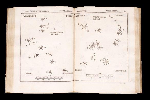
‘De Le Stelle Fisse’ was the first printed star atlas and “the first handbook for stargazers” (Gingerich), identifying each of the 48 Ptolemaic constellations. Piccolomini was the first to use a lettering system to identify the prominent stars in each constellation, a practice later copied by the German astrologer Johann Bayer, whose work forms the basis of the system of star nomenclature we use today. Piccolomini used Ptolemy’s system of star magnitudes, although he reduced it to four rather than five, and assigned different symbols to each one. The charts show only the shape of the constellations, rather than overlaying them with a pictorial map. The constellations are often not oriented to the north, but shown in their most recognisable position, making it easy for the amateur astronomer using the book. Any myths associated with the constellation are added in the accompanying text.
Unusually for scientific works of the time, they are both written in Italian rather than Latin. While at university in Padua, Piccolomini had been a member of the Society of Infiammati, which strove to promote the vernacular, and had helped to found the Society of Intronati in Siena with a similar aim. It is also exceptional in that it is dedicated to a woman, Laodomia Forteguerri, whereas women were more commonly the dedicatees of poetry or tracts on feminine virtues. Forteguerri, however, was herself exceptional: a Sapphic poet who led a team of women to help build defences when Siena was besieged by Charles V. Piccolomini admired her sonnets and delivered a lecture on them to the Infiammati, the first secular Italian female poet to have her work discussed in an academic setting. He supposedly dedicated ‘De la Sfera del Mondo’ and ‘De Le Stelle Fisse’ to her after she complained that she could not study astronomy because she was a woman. It is certainly true that traditional academic texts would be barred to anyone without a classical education (which most women did not have), which adds weight to his decision to publish in the vernacular to reach a wider audience.
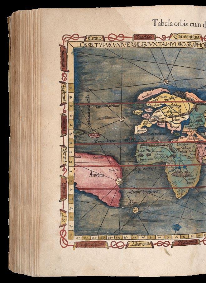
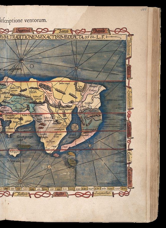
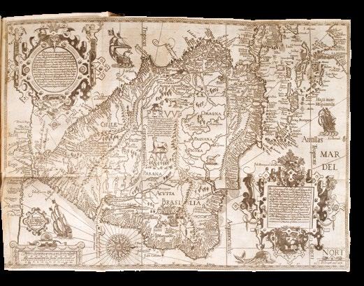
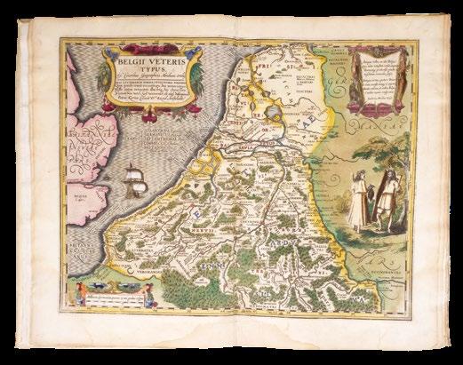
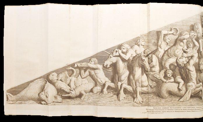
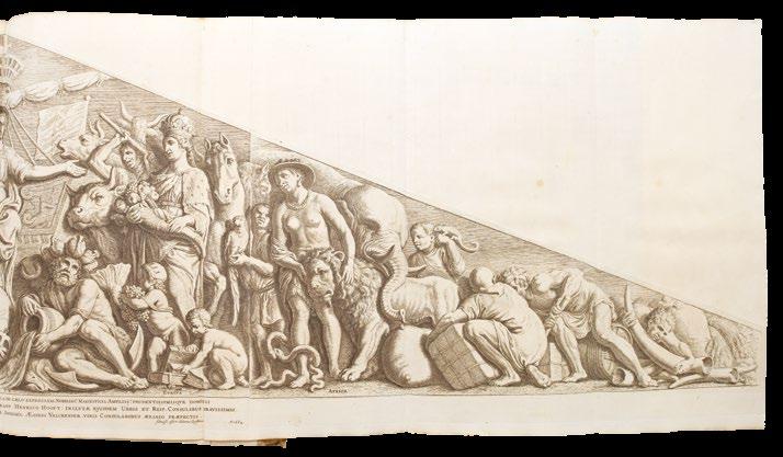
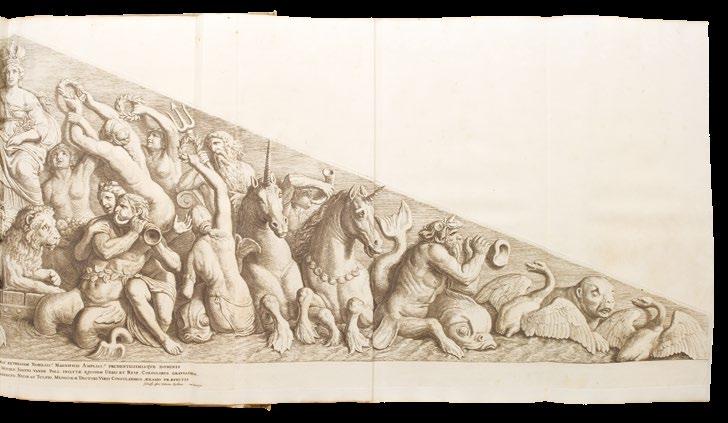
PTOLEMAEUS, Claudius; and Michael VILLANOVANUS, known as ‘SERVETUS’
Geographicae Enarrationis, Libri Octo. Ex Bilibaldi Pircheymheri tralatione, sed ad Graeca & Prisca exemplaria a Michaele Villanovan (d.i. Servertus) secondo recogniti, & locis innumeris denuo castigati.
Publication
Prostant Lugduni, apud Hugonem a Porta, 1541.
Description
Folio. Large woodcut printer’s device on title-page; double-page woodcut old map of the world, 26 old regional maps, 2 modern maps of the world, 20 new regional maps and one full-page, most with text enclosed in elaborate woodcut borders, probably by Hans Holbein and Urs Graf, text with 2 full-page woodcuts of a diagram and armillary sphere showing the projection of the winds by Albrecht Dürer (l4 verso), all with magnificent contemporary hand-colour in full, 4 large woodcut diagrams, woodcut initials, colophon n4 present, seventeenthcentury limp vellum.
Alden & Landis 541/9; Burden 4; Davis ‘On the Protestantism of Benoit Rigaud’, 1955, page 246; Phillips Atlases 366; Sabin 66485; Shirley 47-49.
€240,000
The first map in an atlas to name America; Ptolemy’s third projection
Beautifully coloured in a contemporary hand throughout, and very rare as such, this is the second edition of Ptolemy’s ‘Geographia’ to be edited by Michael Villanovanus, better known as Servetus, (c.1490-1570). It was printed by Gaspar Trechsel for Hugues de la Porte (1500-1572) in Lyon, a well-known protestant publisher and bookseller, and a prominent member of the Grande Compagnie des Libraries de Lyon (founded in 1519), many of whose works were on the list of condemned books, some of which were destroyed on the banks of the Saône by order of the Archbishop in 1568 (Davis).
Nevertheless, the most inflammatory remarks from the earlier editions of the text have been removed. While working as an editor for the publishers Melchior (c.1490-1570) and Gaspar Trechsel, Servetus, who was born at Villanueva, in Aragon, Spain, wrote the preface and many of the descriptions for the versos of these maps, for an edition which was first published in 1535. He unwittingly translated verbatim the text accompanying map 41, ‘Tab. Ter. Sanctae’, of the Holy Land, from the 1522 and 1525 editions, in which it states that Palestine “was not such a fertile land as was generally believed, since modern travellers reported it barren”. Excising the offensive text for this new edition did not save Servetus, when he was burnt at the stake in 1553, this heresy was charged to him, along with 39 other counts, which included the sins of writing against the Holy Trinity and infant baptism. As a result, many copies of the book were burned with him on the orders of John Calvin.
The maps, which are very rarely found with such fine contemporary colour, as here, include 27 depicting the ancient world, 22 of the modern world, and one of Lotharingia. They are printed from the same woodblocks that were created by Laurent Fries for the 1522 edition of Ptolemy’s ‘Geographia’, after the original 1513 maps of Martin Waldseemuller (1470-1520). Fries was originally a physician, at a succession of places in the Alsace region, with a short spell in Switzerland, before settling in Strasbourg, in about 1519. By this time, he had established a reputation as a writer on medical topics, with several publications already to his credit. Indeed, it was thus that Fries met the Strasbourg printer and publisher Johann Grüninger, an associate of the St. Die group of scholars formed by, among others, Walter Lud, Martin Ringmann and Martin Waldseemuller. It would seem that Gruninger was responsible for printing several of the maps prepared by Waldseemuller, and for supervising the cutting of the maps for the 1513 edition of Ptolemy, edited by the group.
Three of the maps relate to the Americas: ‘Terra Nova’, the first map in an atlas dedicated to America; ‘Tabula noua totius orbis’, to which he added images of Russian, Egyptian, Etheopian, Trapobanan and Mursulian kings, and an elephant off the coast of Greenland; and ‘Orbis typus universalis’, the ‘Admiral’s map’, and the first map in an atlas to name America’.
Albrecht Durer (1471-1528) created his image of the armillary sphere for the Gruninger edition of Ptolemy’s Geography, 1525. His simple and elegant rendition of the inhabited parts of the globe, within the floating spherical astrolabe, is less a scientific instrument and more a framework for the schematized world; belying the complex nature of Ptolemy’s text.
MÜNSTER,
Sebastian
Cosmographei, oder beschreibung aller lander, herrschafften, fürnemsten...
Publication
Basel, Heinrich Petri, 1550.
Description
Folio (330 by 215mm). Letterpress titlepage with woodcut architectural border, 111 woodcut maps, plans, and views, including 63 double-page, illustrated with over 900 vignette woodcuts; contemporary panelled pigskin over bevelled oak boards, roll-tooled border containing small portraits, double central panels composed of different flower roll tools, original brass clasps and catches, manuscript title on a paper label on the spine, in five compartments separated by raised bands, marginal annotations in two hands, including in Hebrew, a few small tears in top and bottom margins, two affecting text, one skilfully repaired, water stains towards the end in the bottom margins.
References BL, T.MUN-1c; Burden, 12; Burmeister, 87; Graesse, IV: 622; Oehme, ‘Introduction fo the Facsimile of the 1550 Edition of Münster’s Cosmographia’; Ruland, 84-97; Sabin, 51380; Shirley, [Atlases], T.MUN-1c.
€60,000
The Book that “sealed the fate of ‘America’ as the name of the New World”
A fine example of Sebastian Münster’s “Cosmography”, containing the first separate printed map of the Western Hemisphere; the first “set” of maps of the four continents, and the first printed map to name the Pacific Ocean.
The cartography
While individual continents had been mapped as entities, in print, before 1540 (Africa in Montalboddo’s ‘Itinerarium Portugallesium’, 1508; Europe by Waldseemüller, 1511; America by Stobniza, 1512; Asia in Münster’s edition of Solinus, 1538), Münster was the first to publish a set of maps of the four continents.
The maps are also famous for their decorative elements - Magellan’s ship, the ‘Victoria’, is prominent on the map of the Americas, the ‘monoculi’ (or cyclops) on the map of Africa, the shipwreck of St. Paul on the second map of Africa, and the drawing of the elephant on the map of Ceylon. Also, the map of Europe is unusual (by modern standards) as being printed with south at the top of the page.
Coming half a century after Columbus’s initial landfall in the Indies, Münster’s map of America is the first separate printed map of the Western Hemisphere, and shows Japan as a hypothetical close insular neighbour of America. Two decades after Magellan’s circumnavigation, it is also the first printed map (along with Münster’s world map) to refer to Magellan’s great ocean by the name he had christened it - Mare Pacificum. Also of note is the strange constriction of the North American land mass towards the top of the continent. This is the first printed depiction of a confusion resulting from Verrazano’s report of the sighting of a ship in a body of water on the other side of an isthmus. Verrazano’s isthmus was, in reality, nothing more than the Outer Banks between Capes Lookout and Henry; his oriental sea, which he thought would lead to the blessed shores of Cathay (China) was, in fact, the Pamlico and Albermarle Sounds. In the Northeast, Münster has labelled Francisca (Canada), named by Verrazano after France and Francis I, shortly before his northerly return back to Europe. In the Atlantic Ocean, Münster has correctly located a Spanish and a Portuguese standard, intended to reflect the division of the unknown world in two by the Papal Treaty of Tordesillas (1494). Zipangri (Japan), still known only from Marco Polo (who had heard tales of it but had never been there), appears as a very large, north-south oriented rectangular island off the “California” coast. In 1540, when the map was created, two or three years would still elapse before the first known European encounter with Japan. The Venetian merchant, Polo, was also the source for Münster’s belief in the complex of 7,448 islands situated between Japan and the Asian mainland. As with Japan, Polo himself never ventured there; but by their number and the description of them given Polo by his hosts, it is likely that these islands were the Philippines. By Münster’s time, direct
European contact with the Philippines had been made, both by Magellan (who died there) and almost certainly by eastward-bound Portuguese explorers before him. (Münster, on his map of Asia, has included the real Philippine island of Puloan.) It was a result of this archipelago of 7,448 islands and Europe’s underestimation of the Pacific’s true vastness that pushed Japan so close to North America on Münster’s map. A large illustration of Magellan’s ship, and the Unfortunate Islands he and his desperate crew passed on their ill-fated voyage, are shown below Japan. Their luckless path across the Pacific bypassed, though barely, islands of the Polynesian groups; these islands were rich in foods that might have sustained many of them, and particularly endowed with the sorts of plants whose citrus content would have spared them scurvy. Disease, violence, and starvation took the lives of all but 18 of the 277 members of the expedition.
The map of Africa also contains many interesting, if not curious, features: a one-eyed giant seated over Nigeria and Cameroon, representing the mythical tribe of the “Monoculi”; a dense forest located in today’s Sahara Desert; and an elephant filling southern Africa. The Niger River begins and ends in lakes. The source of the Nile lies in two lakes fed by waters from the fabled Mountains of the Moon, graphically presented as small brown mounds. Several kingdoms are noted, including that of the legendary Prester John, as well as “Meroë,” the mythical tombs of the Nubian kings. Few coastal towns are shown, and there is no sign of the vast island of Madagascar. A simplified caravel, similar to those used by the Portuguese (and Columbus), sails off the southern coast. One of the intriguing aspects of this map is the loop of the Senegal River, which is shown entering the ocean in today’s Gulf of Guinea. Actually, this is the true route of the Niger River, but that fact will not be confirmed until the Lander brothers’ expedition in 1830. Strangely, this loop disappeared from subsequent maps of Africa for the following two hundred years!
A further interesting feature of the work is the plate of monsters of both land and sea, taken from Olaus Magnus’ ‘Carta Marina’ of 1539, with abundant tusks, horns and twin-spouts. One vignette shows a galleon trying to outrun a monster by throwing their cargo overboard, while one sailor takes sight with a musket. Ortelius also adapted many of the monsters for use on his map of Iceland in 1587.
The mapmaker
Sebastian Münster (1488–1552), cosmographer, humanist, theologian and linguist, was famous in his own age as a Hebraist, composing a Hebrew grammar and a list of Hebrew, Latin and Greek synonyms which were used widely by sixteenth-century humanists. A Franciscan friar from around 1506, Münster studied in Tübingen and taught in Basel and Heidelberg before leaving the order and moving to Basel in 1529, where
he took up the chair in Hebrew. Whilst in Basel, Münster indulged in his other great love: that of cartography. The love affair had begun some years earlier in Tübingen, when under the tutelage of Johann Stöffler. Münster’s notebook of the time contains some 43 manuscript maps, most of which were based upon others’ work, except, that is, for his map of the Rhine from Basel to Neuss.
Münster would produce his first map in a printed broadsheet of 1525. The map, which covers Germany, also came with an explanatory text (only extant in the second edition of 1528), which lays out Münster’s vision for a new great survey of Germany. He readily conceded that the job was too great for one man and so called upon fellow academics to cooperate and supply detailed maps and text of their respective areas, with Münster working as the great synthesiser. Although the project would never get off the ground, much of its methodology and material would be used, with great success, in his ‘Cosmographia’.
Throughout the next decade he produced, and had a hand in, several important works that would cement his reputation as one of the leading cartographers of his day; these included, among others, Johann Honter’s celestial charts (1532), his own ‘Mappa Europae’ (1536), and Aegidius Tschudi’s map of Switzerland (1538). In 1540, he published his edition of Ptolemy’s ‘Geographia’, which contained not only new maps of Germany and the Low Countries, but also, for the first time, a set of maps of the four continents.
In 1544, Münster produced his greatest work, the ‘Cosmographia’. It was the culmination of a lifetime’s study, in which he distilled the geographical information he had gathered over the past 30 years.
Münster organises the work in a series of periegesis or geographical travels. He begins by describing the area’s geography, history, ethnography, flora and fauna, and, famously, strange peoples, fabulous plants, and wondrous events.
The work would prove to be so popular that some 40 editions were published between 1544 and 1628, with the number of maps expanding from 26 in the 1544 to 262 by 1628. Its huge popularity would not only - as Burden states - “seal the fate of America as the name of the New World”, but would form the basis of general knowledge of many other parts of the world as well.
Provenance
1. Otto Schäfer Stiftung, Schweinfurt, Germany; 2. Ex Libris Dr F Buffner on the front pastedown; 3. Library stamp on title-page.
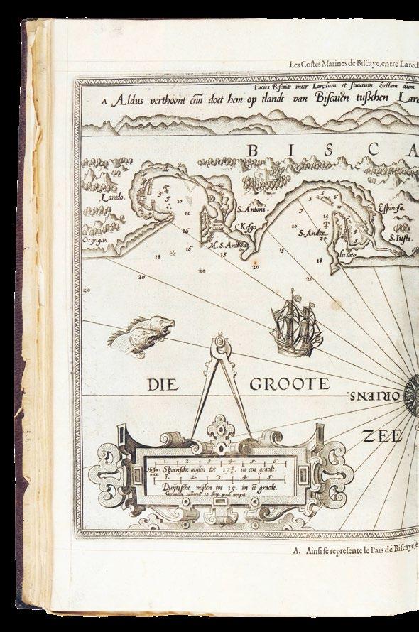
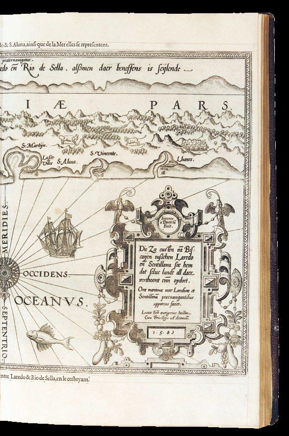
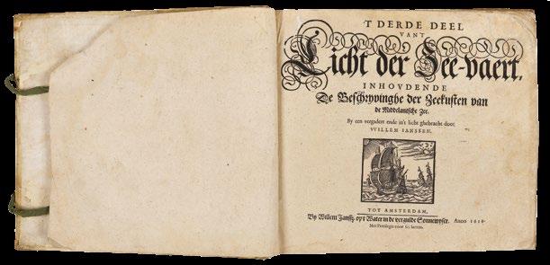
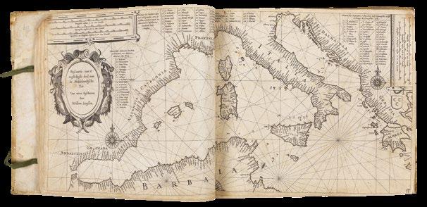
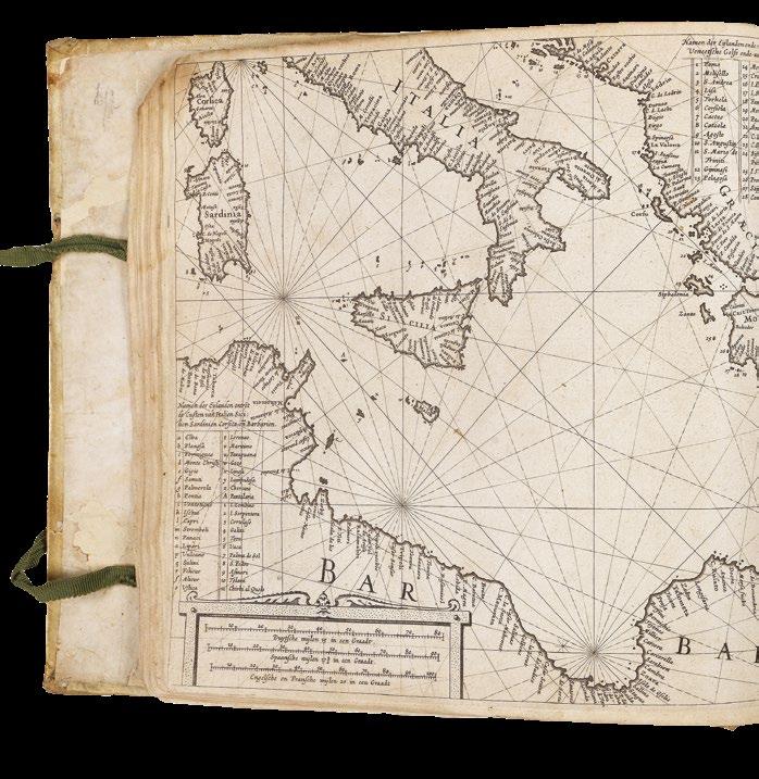
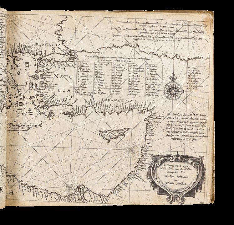
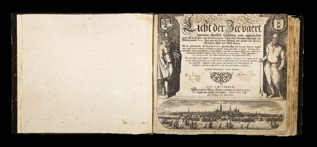
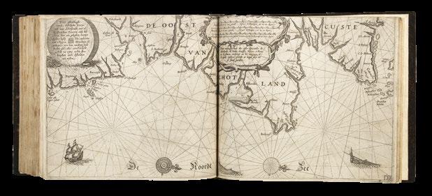
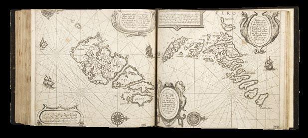
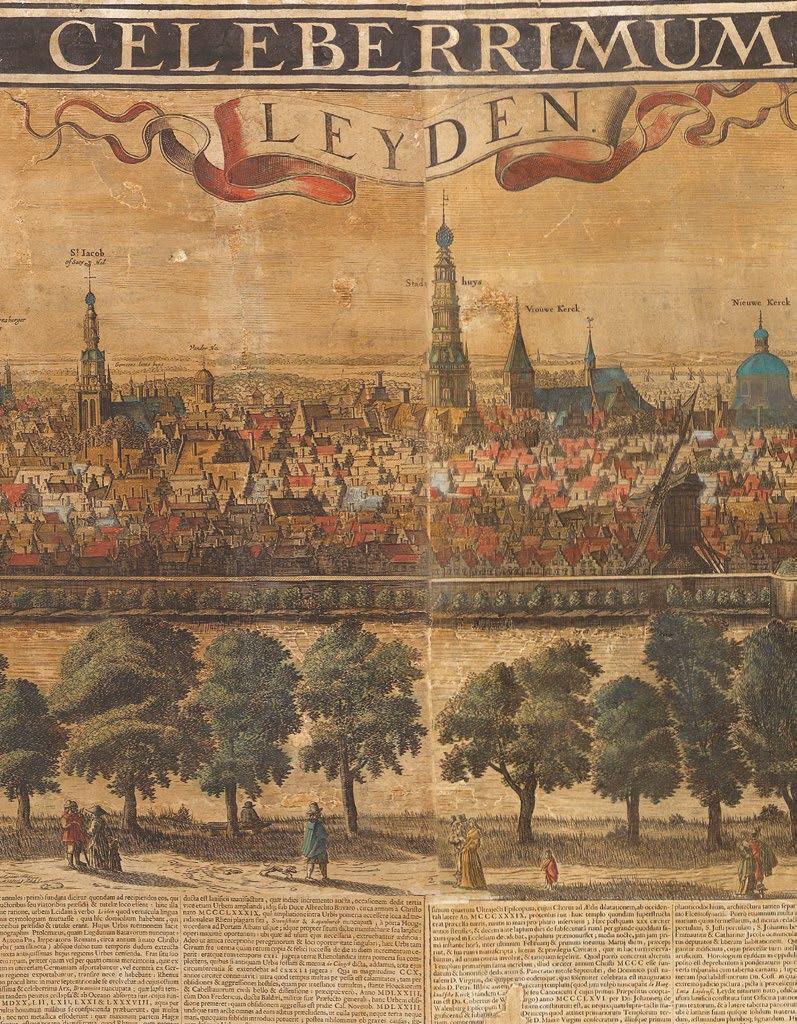
WAGHENAER,
Lucas Janszoon
Teerste Deel vande Spieghel der Zeevaert.. [and] Der ander Theil. Dess Spiegels der Seefart.
Publication
Amsterdam, Christofel Plantijn and Cornelius Claesz, 1589.
Description
Two parts in one volume. Folio. Two engraved title pages, 47 engraved charts, title and all in fine original colour in full, omitting 36pp. text to first part; contemporary calf, blind-stamp fillet roll border, and corner arabesques, large central arabesque with lions head, spine in six compartments, separated by raised bands.
References
Kpeman Wag 1B and Wag 6. BM STC, Dutch Books S. 209; Goedings Kunst in Kaart, Utrecht 1989, p.104-106, 110-113; Koeman, Wag 5A; Nederl. Scheepvaart Mus. I, 44. (see Van Mander 1604 p.258); Phillips/Le Gear 3980; Schilder Monumenta Cartographica Neerlandica, Vol VII; Tiele 1191 Anm; Skelton, “Bibliographical note” in the facsimile edition, Amsterdam, 1966.
€400,000
The first printed sea pilot
Superb example of Waghenaer’s sea pilot in fine original full wash colour.
“Waghenaer’s work was a milestone in the development of West European navigation. His charts brought together the pictorial silhouettes that had been a standard feature of traditional rutters used by pilots, and combined these with updated coastal outlines. In addition, there were compass roses and lines of navigational direction, as well as soundings to help navigators make their way into ports and havens” (Schilder).
After a long career at sea, Waghenaer became collector of maritime dues in his hometown of Enkhuizen in 1579. Losing this post in 1582, he began work on what was to become one of the most successful maritime books of its age: a pioneering synthesis of information from manuscript charts, rutters, ships’ logs, all of which he systematized for the first time, illustrated with informative and beautifully engraved charts.
The demand for Waghenaer’s charts required translations for foreign pilots, and this Latin version was only the first, with subsequent translations into English, German, and French. The atlas was “the greatest single advance in the history of hydrographic publication. Within the covers of a single work it provided the seaman with a manual of practical navigation, a set of printed charts on a common scale, covering the coasts and waters of northern and western Europe, and sailing directions which were otherwise only to be found in rutters unaccompanied by charts” (Skelton). Published charts of the coast of Europe were based on Waghenaer’s work for at least a century, and all such later collections of sea charts were called after him “waghenaers” or “waggoners” in English and “chartiers” in French.
The present example conforms in part to Koeman Wag 6 - the first German edition - though with a few exceptions: the title and dedication of the first part is taken from first Dutch edition - dated 1584 - but with the 36 text pages omitted. All charts in the first and second part bear German text above the charts, an are in state ‘D’, having been reworked by Claesz. The distribution of the charts, is also slightly different, with 21 in the first part, and 26 in the second. These amendments, due to the contemporary binding, and the consistency of the colour, would appear to have been intentional.
Provenance
Manuscript inscription in a nineteenth cnetury hand, to the front paste down: “Exlibris des a Geizkofler Zacharias 1605 b) Brösamer Augustin 1706”. The two ex-libris have been removed. Zacharias Geizkofler (1560-1617) was born in Brixen in 1560 and he died in Prague in 1617. A Lutheran active in literature. He was a lawyer, diplomat and imperial councillor. He came from an old Tyrol family settled in Jáchymov and in Augsburg. He studied in Strasbourg and in Basel; from 1597 until his death, he was the Master of the Imperial Mint as well as a councillor to the emperors Rudolf II and Matthias. During the reign of Emperor Rudolf II, Geizkofler cooperated with large banking houses and participated in the organization of the so-called anticipation loan. His agenda included securing the funding for the Turkish wars. Like other members of the family, he also worked as a diplomat in the service of the Fuggers. In the town of Haunsheim, he built a magnificent Renaissance residence. He was famous for his charitable work for the poor and the abolition of serfdom. In 1603, Geizkofler acquired the library of Anton Fugger, a German merchant, banker, and member of the Fugger family. He was a nephew of Jakob Fugger.
WAGHENAER, Lucas Janszoon
The Mariners Mirrour... Herein also may be understood the exploits lately atchived by the Right Honorable the L. Admiral of England with Her Ma[jes]ties Navie; and some former services don by the worthy Knight S[i]r Fran[cis] Drake.
Publication [London, J. Charlewood for ?H. Haslop, 1588].
Description
Two parts in one volume. Folio (391 by 266mm). Two engraved titles, engraved coat-of-arms of Sir Christopher Hatton, small engraved radial plate tipped in to A1, 3 engraved plates with volvelles, 45 double-page engraved charts, several charts with early hand-colour, some offsetting to a few charts; contemporary calf, gilt, spine in compartments, separated by raised bands, gilt.
References Koeman, Wag 13; ESTC, S122236; Hind, ‘Engraving in England’, 151–153; Koeman, ‘The history of … Spieghel der Zeevaerdt’, Lausanne, 1964; Skelton, ‘Bibliographical note’ in the facsimile edition, Amsterdam, 1966; Waters, ‘Art of navigation’, London, 1958; Waters, ‘Waghenaer’s … influence on English hydrography’ in ‘Lucas Jansz. Waghenser van Enckhuysen’, Enkhulzen, 1984.
€235,000
The first sea pilot printed in English
“In 1587 the English translation of Waghenaer’s ‘Speighel der Zeevaert’ was commissioned by the Lord Chancellor, Sir Christopher Hatton. The translation was carried out by Anthony Ashley, Clerk of the Privy Council, who used the 1586 Latin edition as a model. New plates were cut by De Bry, Jodocus Hondius, Augustine Ryther, and Johannes Rutlinger” (Koeman).
The maps are some of the earliest engraved in England and the atlas, as well as being the first printed sea atlas, was the first book to standardize symbols of buoys and beacons. The maps for the English edition were simplified from the earlier versions, removing the wavy lines chosen to represent the sea to make the rutter more useable onboard ship. The ornamental ships and sea monsters were retained, in part because the ships were useful to the mariner in determining location as the vessels depicted correspond to the stretches of coast shown. Such considerations do not, however, detract from the decorative appeal of the charts and the book “outranks any other rutter of its period, with its splendid presentation of charts and text; as such it stood as a model for the folio-sized charts and pilot guides with charts in the seventeenth century”(Koeman). Such was the popularity of this work in England that all subsequent sea atlases and pilots became commonly known as ‘waggoners’.
An exceptionally rare item. ESTC lists fifteen examples of the book, all in institutions; Koeman cites only eight. We are aware of one other complete example of this work coming up for sale in the last thirty years: the Wardington copy, sold for £90,000 plus premium in 2006. The present example was offered by John Howell Books in 1982, for $85,000.
GONZALEZ dE MENDOZA, Juan; and Giuseppe ROSACCIO
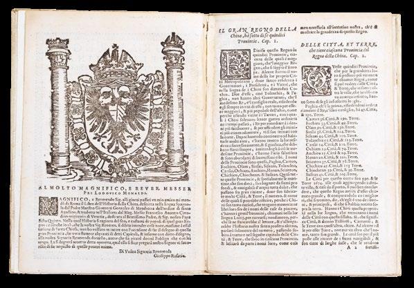
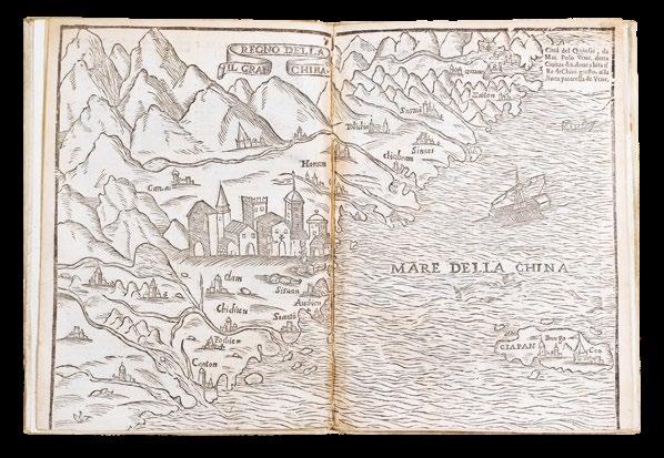
Il gran regno della China, novamente dalli Reverendi Padri di S. Agostino, S. Francesco, & Gesù, discoperto Si narra dell’isola del Giapon. Con l’arrivo d’essi signori Giaponesi à Goa.
Publication Venice, Brescia and Bologna, G. Rossi, 1589.
Description
Small quarto (210 x 140mm). 8 leaves, title- page decorated with a woodcut border and the Arms of Philip II on the verso, double- page woodcut map; modern vellum.
References
Cordier 10-11; Palau 105507 note; StreitDindinger IV, 2008.
€33,000
The first map to show Korea as a peninsula, the only known example of this issue
The first appearance of Giuseppe Rosaccio’s influential map of China (Cordier), to illustrate the work of Gonzalez de Mendoza, showing Korea as a peninsula.
Juan González de Mendoza (1545-1618) was a Spanish bishop and briefly one of Europe’s leading authorities on China. Although he never in fact visited the East himself, González published a ‘Historia de las cosas más notables, ritos y costumbres del gran reyno de la China’ (The History of the most notable things, rites and customs of the Great Kingdom of China) (1585). It was based on the journals of Spanish explorer Miguel de Luarca, who had made a journey to Ming China five years earlier.
Accompanying excerpts from González’s descriptive text is a woodcut map of China by Rosaccio. The Venetian Rosaccio was primarily a physician, serving Grand Duke Cosimo II in Florence from 1607. He was also a prolific author, however, the majority of his forty written works concerning geography and exploration. For the ‘Historia...de la China’ he produced this iconic map that would help shape the European perception of China for several decades, not least through its influence on the work of cartographers such as the de Jodes. It is the first map to show Korea as a peninsula, in contrast to the cartographic myth of the Korean island that persisted for centuries to come.
Although it was soon superseded by the research and experiences of Jesuit missionaries in the early-seventeenth century, and despite accusations of plagiarism from the work of Bernardino de Escalante, the ‘Historia... de la China’ was a great publication success, with an Italian translation appearing in 1586 and an English version two years later. The present example is one of these rare Italian editions, published in 1589, in this case by Giovanni Rossi, with another issue published simultaneously, in Bologna and Florence, by Francesco Tosi. Founded in 1633, the de Rossi printing press was the most important and prolific in Rome during the seventeenth century. Just before the death of its founder, Giuseppe de Rossi (1570-1639), it was inherited by his son Giovanni Giacomo (1627-1691).
Rare: apparently the only known example issued by Rossi, with only the Tosi issue recorded in commerce (2011), and in the New York Public Library.
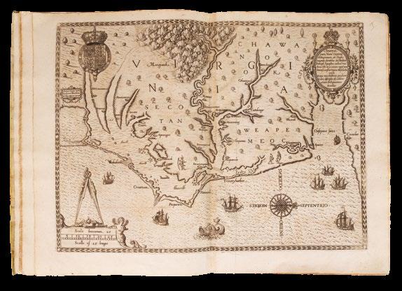
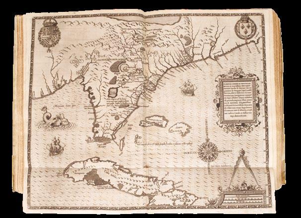
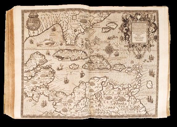
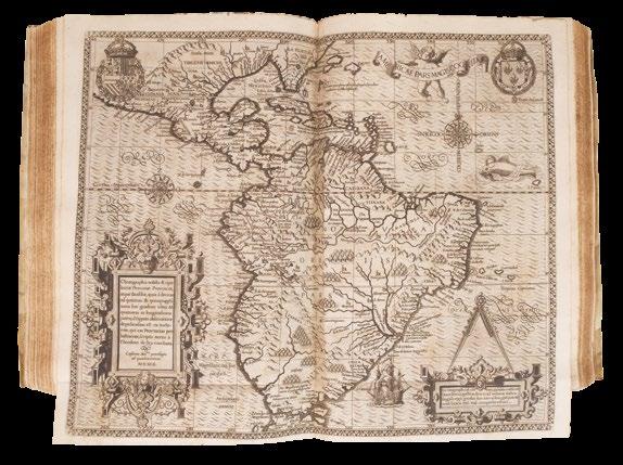
BRY, Theodor de; Thomas HARIOT; John WHITE; Jacques LE MOYNE DE MORGUES; Hans STADIUS; and Girolamo BENZONI
A sumptuous sammelband of the first four “Grand Voyages”.
Publication Frankfurt, Johan Wechel, 1590 - 1594 [1597].
Description
First editions. Folio (340 by 250mm). Four parts in one volume: I ‘Virginiae’: doublepage engraved map, 28 half- or full-page plates; II ‘Florida’: double-page engraved map, 42 half-page plates; ‘Brasiliae’: double-page engraved map, 46 half-page plates; ‘Americae’: double-page engraved map, 24 half-page plates; contemporary limp vellum, elaborately decorated in silver with fillets, roll-tools, corner-pieces and arabesques, all edges gilt and gauffered, remains of 4 silk finger tabs, and 2 pairs of ties.
References
I. Burden 76, Church 140; II. Burden 79, Church 145; Burden 80, Church 149; Burden 83, Church 153
€265,000
The New World bound in silver and gold
An exceptionally fine collection of the first four parts of De Bry’s famous and influential collection of “Grand Voyages” to the New World, in a magnificent contemporary binding, decorated in silver and gold.
De Bry’s “Grand Voyages” is one of the finest collections of voyages published during the early golden age of European exploration, and presents more than a century of European effort to take possession of the New World, materially and intellectually. The collection is famed for the quality of its ethnographic and biological illustrations, produced, for the most, part using authentic models and the iconography disseminated via this popular work dominated the European view of the new world for more than a century after its publication.
The history of the publication of the “Grand Voyages” is neatly summarized in the Church catalogue as follows: “Theodor De Bry, who began the publication of this collection of voyages, was born in 1528 and died in 1598, after having published Parts I to VI of the Great Voyages. He was a skilful engraver, and many of the plates in these parts were from his own burin. In 1587 he journeyed to England, where he met the great chronicler Richard Hakluyt. Hakluyt persuaded him to undertake the formation of a collection similar to his own, and furnished him with a copy of Hariot’s ‘Virginia’, the first work brought out by De Bry.
Three years later De Bry published Part I of the “Great Voyages” in Latin, German, French and English. There does not appear to have been enough encouragement for him to continue the publication in the last two languages, for the succeeding parts were published only in Latin and German”.
The content of the individual parts is as follows:
Part I. [Thomas Hariot’s Virginia.] ‘Admiranda narratio fida tamen, de commodis et incolarum ritibus Virginiae…’. Francoforti ad Moenum, 1590. First edition, first issue. Engraved title-page, engraved arms on dedication leaf, full-page engraved plate of Adam and Eve, double-page engraved map ‘Americae pars, Nunc Virginia’, 23 numbered engraved plates of local scenes and native Virginians, including 2 double-page and mounted on guards, some full-page, and a further five numbered full-page plates of Picts.
Collation: a4, b6, c4, d8; A-C6, D4, E8, F6; pages [1]-34, leaves [3], map, plates II - XXIII, plates I - V (each interleaved with a single leaf of text), leaves [5].
Thomas Hariot’s account of the British Roanoke colony. This is the the first eyewitness pictorial record of the American southeast, the first illustrated account wholly dedicated to any portion of what is now the United States, and provides the best account of the first attempt at British colonization in the New World. De Bry adapted the original watercolors of John White, depicting the Carolina Indians, to illustrate
the work. These engravings are the best pictorial record of American Indians before the nineteenth century. The famous map, ‘Americae pars, Nunc Virginia’, here in the rare first state, is “one of the most significant cartographical milestones in colonial North American history. It was the most accurate map drawn in the sixteenth century of any part of that continent. It became the prototype of the area until long after James Moxon’s map in 1671’ (Burden 76). This is one of the most important early works on the settlement of North America.
II. [Jacques Le Moyne de Morgues’s Florida.] ‘Brevis narratio eorum quae in Florida Americae provincia Gallis acciderunt…’. Francoforti ad Moenum: Iohanis Wecheli, 1591. First edition. Engraved title-page, engraved arms on dedication leaf, engraved vignette of Noah offering a sacrifice, engraved title-page, double-page and folding engraved map ‘Floridae Americae provinciae’, 42 numbered engraved plates of local scenes and native Floridians.
A collection of accounts relating to the attempted settlement of Florida by French Protestants in the 1560s. The text is drawn from the accounts of Jean Ribaut, René de Laudonnière, and Dominique de Gourgues, and describes the foundation of the colony in 1562 and its difficult existence until the massacre of the settlers by the Spanish in 1565. De Bry illustrated this part with engravings after the watercolors of Jacques Le Moyne, depicting the life and ceremonies of the Florida Indians. As ethnographic documents, these are second only to those of John White, as records of American Indian life in the sixteenth century, and like White’s work, these illustrations remained unrivalled until centuries later.
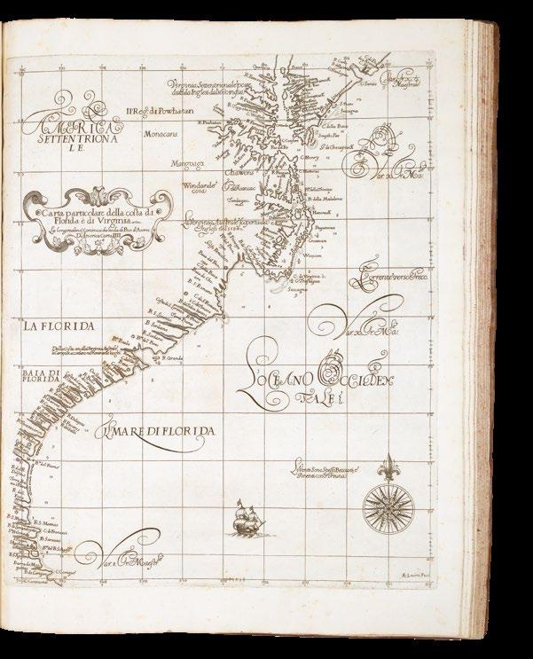
The map, ‘Floridae Americae provinciae’ (Burden 79) which appeared for the first time with this text, is one of the most elaborate of the Florida peninsula to appear in the sixteenth century, giving the names assigned by the French and Spanish. Cumming provides an elaborate description, and John Matthew Baxter describes it as “…the most remarkable and important map, which has been preserved from the sixteenth century maps, of that part of the East Coast which lies between Cape Hatteras and Cape Florida … [It is] the first French map to show Florida … [and is] considered the most important map of Florida”.
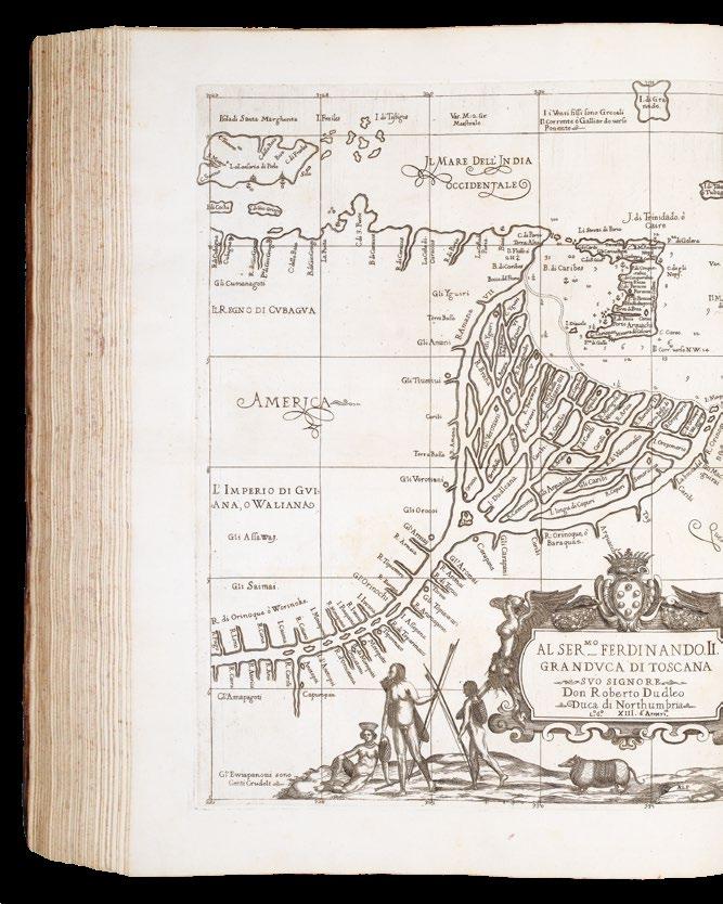
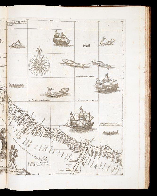
III. [Hans Stadius’s Brazil.] ‘Americae Tertia Pars Memorabile provinciae...’. Theodori de Bry Leodiensis, atque civis Francofurtensis anno MDXCII (on an overslip)... Venales repernitur in officina Theodori de Bry, [c.1597]. First edition, second issue. Engraved title-page, engraved arms on dedication leaf, engraved plate with seven armorials, 35 engraved vignettes, engraved title-page, full-page plate of Adam and Eve, double-page and folding map ‘Chorographia nobilis & opulentae Peruanae Provinciae, atque Brasiliae... MDXCII’, 10 engraved vignettes, letterpress title-page.
Two accounts related to Brazil. The first is that of Hans Staden, a German mercenary in Portuguese service who was captured by the Tupi Indians. His is one of the first detailed accounts of South American Indians. The De Bry engravings, based on Staden’s drawings, are significant ethnographic documents. The second part is the sensitive narrative of Jean de Léry, a French Calvinist minister who lived among the Indians, whose illustrations are also important. This part is a seminal work on the early colonial period in Brazil, illustrated by the first state of the map ‘Chorographia nobilis & opulentae Peruanae Provinciae, atque Brasiliae’ (Burden 80).
IV. [Girolamo Benzoni’s History of the New World.] ‘Americae pars Quarta sive, Insignis & Admiranda Historia de reperta primum Occidentali India a Christophoro Columbo anno MCCCCXCII Scripta ab Hieronymo Benzono’. Francofurtensi Anno mb[sic]xciiii [1594]. First edition, first issue. Engraved title-page, engraved plate with seven armorials, engraved vignette of Columbus, engraved vignette ‘Americae retectio’, engraved title-page, double-page map ‘Occidentalis Americae partis’, 24 engraved vignettes. Collation: ):(4, ):():(4, A-Q4, R6 (R6 is blank), A-E4; F6 (F6 is blank); leaves [4], pages 1 - [146], leaves [2], map, plates I - XXIII, leaf [1]. Benzoni’s account of his fifteen years of travel in the Isthmus of Panama and Guatemala was first published in Venice in 1565: “It was [written] at the time when the controversy concerning the treatment of the Indians was hottest, and a work, written by one who had just returned from the New World after a stay of fifteen years could not fail to attract attention. In writing it, no standard of criticism was applied; this was not in the spirit of the times. The ultra-philanthropists found Benzoni a welcome auxiliary, and foreign nations, all more or less leagued against Spain for the sake of supplanting its mastery of the Indies, eagerly adopted his extreme statements and sweeping accusations” (Catholic Encyclopedia). The map, ‘Occidentalis Americae partis’ (Burden 83) illustrates the discoveries of Christopher Columbus.
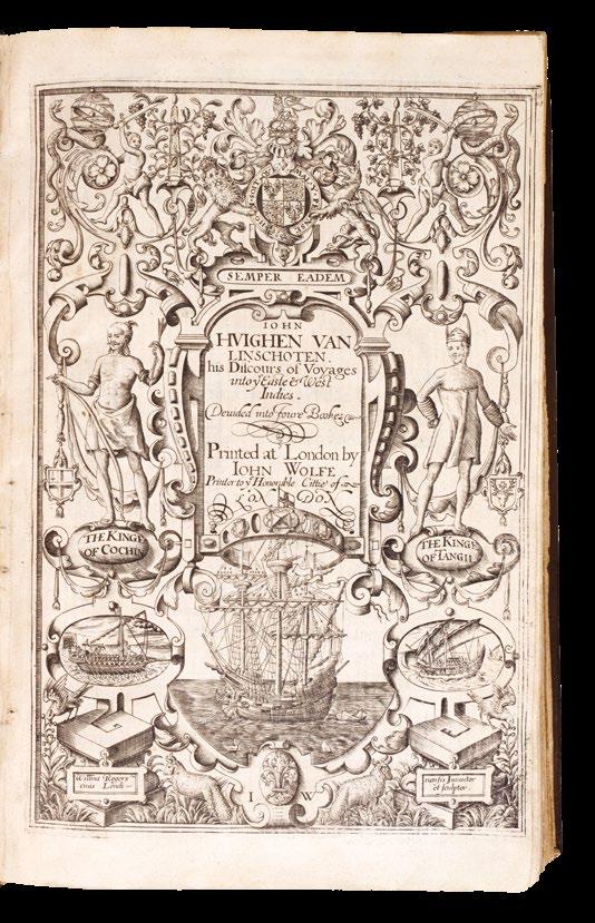
LINSCHOTEN, Jan Huygen van.
John Huighen van Linschoten his Discours of Voyages unto ye Easte & West Indies. Devided into Foure Bookes.
Publication
London, John Wolfe, 1598.
Description
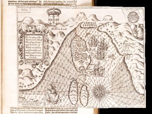
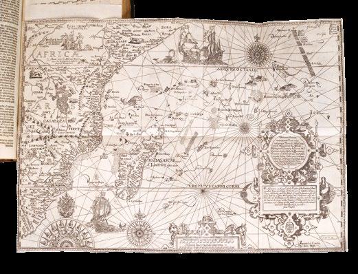
Four parts in one volume. Folio (285 by 180mm). Mostly black letter, double column. [6] leaves, blank, engraved general title-page by William Rogers (Johnson, p.2, Rogers no.3), dedication, ‘To the Reader’, pages numbered 1-197 ‘The First Booke’, [1] leaf sectional vignette title-page with engraved map of the Congo, pages numbered [197]- 259 (ie 295) ‘The Second Booke’, [1] leaf sectional vignette title-page with engraved double- hemisphere map of the world, Shirley 182, pages numbered 307- 447 ‘The Thirde Booke’, [1] leaf sectional vignette title- page with engraved map of Spain, pages numbered [451]-462 ‘The Fourth Booke’; double-page engraved folding map of the world ‘Typus Orbis Terrarum’ (Shirley 169), 8 large doublepage folding maps, and 3 folding views of St. Helena and Ascension, 4 woodcut maps in text, woodcut initials, factotums and head-piece ornaments; full contemporary English calf, each cover ruled in blind with central gilt arabesque, the spine in seven compartments, citron morocco letteringpiece in one, the others decorated with a gilt ingot and pincer tool, upper hinge just starting at the head of the spine, endpapers renewed at early date.
Alden and Landis, 598:57; Borba de Moraes, I:417; Church, 321; ESTC, S111823; Hill, 182; Howgego, L131, G40; Luborsky and Ingram, 509; Parker, 159-161; Sabin, 41374; Schilder, 195228; Shirley [World], nos. 167 and 216; Shirley [Atlases], G.Lin 2a; Streeter Sale, 1:31; Worms, 1705; Worms and BayntonWilliams.
€265,000
“The navigator’s vade mecum for the Eastern seas” - one of the most influential English travel books of the sixteenth century
The very rare English edition of Linschoten’s ‘Itinerario’, first published in Dutch in 1595-1596, and translated from the Dutch by William Phillip.
Linschoten’s was the first printed work to include precise sailing instructions for the East Indies. Its exposition of a route to the south of Sumatra through the Sunda Strait allowed Dutch and, later, English merchants to circumvent the Portuguese stranglehold on passage, and, therefore, trade, to the East through the Straits of Malacca. This enabled the British East India Company and the Dutch East India Company to set sail for the Spice Islands and, ultimately, China and Japan, and was of such economic utility that, according to Church, and others, “it was given to each ship sailing from Holland to India” and soon became “the navigator’s vade mecum for the Eastern seas” (Penrose).
“This important work contains all the knowledge and learning related to the East and West Indies and navigations to those parts that was available at the end of the sixteenth century. It was held in such high esteem that for nearly a century a copy was given to each ship sailing to India as a guide to the sailing directions. The fact that most copies were in continual use is in no doubt the reason that fine copies, especially with all correct plates and maps, are so very rare” (Hill).
The work is made up of four parts. The first, provides the account of Linschoten’s travels in Asia and includes accounts of east coast of Africa, Arabia and as far east as Japan. The chapter is accompanied by fine folding maps of the world, Arabia and India, the southeast coast of Africa, a superb map of east Asia and the East Indies and finally one of southwest Africa.
The second book focuses on the west coast of Africa, around the Cape of Good Hope to Arabia and India. It also details the New World accompanying which is a fine map of South America extending northwards to Florida. The third book is derived from the discoveries of the Portuguese Royal pilot Diego Affonso, and details the navigation from Portugal to India, and onwards to the East Indies. Similar detail is also provided for Spanish America and Brazil. Accompanying this is the superb ‘Spice Islands’ map illustrated with spices of the region. The final fourth book provides economic details provided by the territories of the King of Spain.
In fact, until its publication, no other book contained anything like the amount of useful information on the East and West Indies, and it soon became required reading for all navigators sailing to the East, with chapters on the coast of ‘Arabia Felix’, i.e. the southern coast of the Arabian peninsula, the island of Ormus, and Islamic India.
“This is the first work outside of Portugal and Spain to provide detailed practical information on how to get to and engage in trade with America and India. The work was indispensable to sailors on the route to the Indies [and] served as a direct stimulus to the building of the vast English and Dutch overseas empires” (Streeter).
Jan Huyghen van Linschoten (1563-1611)
Linschoten was a native of Enkhuizen who travelled to Spain in 1576 to join his two elder brothers. The family moved to Lisbon during the troubles of 1581. Through family contacts the young Linschoten became attached to the retinue of Vincente de Fonseca as he was sent to Goa as Archbishop. Arriving in September 1583 he spent time travelling through Malabar and Coromandel. All the while he compiled a secret account of his findings. In 1586 Dirck Gerritsz (1544-1604) passed through Goa returning from Japan having also been to China. He was probably the first Dutchman to visit the former. He passed much of his knowledge to Linschoten.
The archbishop returned to Europe in 1587 to report to Philip II but Linschoten remained. Expecting his return, he later found out that he had died at sea. He resolved to return himself and through the auspices of Dutch traders such as the Fuggers and Welsers in India obtained the position of a factor on one of their returning vessels in 1589. He remained on the island of Terceira in the Azores for two years and made his way back to Holland in September 1592. He continued to gather further information from Dutch sailors even accompanied William Barentsz’s second voyage to the Kara Sea in 1594-95. In 1594 he received permission to publish his work. The ‘Itinerario’ was an instant success and combined his first-hand accounts with translations of Portuguese and Spanish documents.
Translation
Word of the significance of the book reached the publisher John Wolfe (fl.1579-1601) who records in the dedication:
“About a Twelvemonth agoe, a learned Gentleman brought unto mee the Voyages and Navigation of John Huyghen van Linschoten into the Indies written in the Dutche Tongue, which he wished might be translated into our Language, because hee thought it would be not onley delightfull, but also very commodious for our English Nation. Upon this commendation and opinion, I procured the Translation thereof accordingly, and so thought goo to publish the same in Print...’. That gentleman was identified in the address to the reader: ‘Which Booke being commended, by Richard Hackluyt, a man that laboureth greatly to advance our English Name and Nation”.
Wolfe was ideally placed to undertake the work, being “the first London bookseller to produce a sequence of map-illustrated works. He clearly kept a rolling-press and was possibly the first regular London book-printer to do so” (Worms & Baynton-Williams). The translation was undertaken by William Phillip. The maps and plates were engraved by Robert Beckit, Ronald Elstrack and William Rogers. Most are re-engravings of those in the Dutch edition. “Wolfe’s turbulent career, his clashes with his old master John Day and the Stationers’ Company, his imprisonments, secret presses, and faked imprints have sometimes obscured his other
achievements. He had an extensive international trade and was ‘the father of news publishing’ in London” (Worms).
“Financial help came from a group of London merchants who provided ten pounds to Hakluyt to see the book in print alongside a further thirty shillings towards the production of maps to accompany it” (Parker).
Illustration
The English edition did not include copies of the thirty or so illustrations of native peoples found in the Dutch edition.
List of maps
Most of the maps and views of the English edition are re-engravings of the plates of the original Dutch edition of 1595-1596, with captions in Latin and English.
1. [Anonymous after] ORTELIUS, Abraham, ‘Typus Orbis Terrarum’. An English derivative of Ortelius’ more up to date plate of 1587 and the earlier more decorative cloud border. Shirley (1993) 167.
2. [Mozambique], ‘The description of the Islandes and Castle of Mozambique...’, engraved by William Rogers.
3. [Arabia, the Indian Ocean and India], ‘The description of the coast of Abex...’ A much-improved depiction of the Arabian Peninsula. Al-Qasimi (1999) p. 32 Dutch edition only; Ankary (2001) pp. 74-6, 148-9 referring only to the Dutch plate; Gole (1978) no. 8 listing only the Dutch plate; Schilder (2003) pp. 220-3; Tibbets (1978) no. 51: “The surprising fact about the representation of the [Arabian] peninsula is the close resemblance of the outline to that of a modern map when compared with other engraved maps of the time. There is a vague suggestion of the Qatar peninsula, which is not seen again until the nineteenth century” (Tibbets).
4. [East Africa], ‘The description or Caerd of the Coastes of the Countreys following called Terra do Natal...’, engraved by Robert Beckit, including the western half of the Indian Ocean along the coast of South Africa, all of Madagascar.
5. [Southeast Asia], ‘The Trew Description of All the Coasts of China...’, extending from the island of Korea and Japan south of ‘Beach’ (Australia), Java, Timor, the Philippines, the Indochina peninsula, and most of the coast and much of the interior of China), Chang (2003) pl. 16, p. 147 Dutch only, p. 192 no. 134 English; Geldart (2017) p. 19; Hubbard (2012) p. 47, fig. 36; Schilder (1976) no. 18 Dutch; Schilder (2003) pp. 222-6; Suarez (1999) pp. 178-9; Suarez (2004) p. 79; Walter (1994) no. 12 Dutch.
6. [St. Helena]
a. ‘The Island of St. Helena full of Sweet and pleasaunt ayre fructfull ground and fresh water...’,
b. ‘The true description, and situation of the Island St. Helena, on the East, North, and West Sydes’, both engraved by Raygnald Elstrak.
7. [Ascention Island], ‘The True Description of the Island of Ascention...’, engraved by William Rogers.
8. [Southwest Africa], ‘The description of the Coast of Guinea...’. Norwich (1983) no. 239a Dutch; Schilder (2003) pp. 215-19; Tooley (1969) p. 67 Dutch.
9. [South America], ‘The description of the whole coast lying in the South Seas of Americae called Peru...’, displays the whole of South America, Caribbean and Florida. Schilder (2003) pp. 226-8.
10. [The Spice Islands Map], ‘Insulae Molucca celeberrimae...’, extends from southeast Asia to the Solomon Islands and northwards to include the Philippines. The famous Spice Island map, so called for its depiction of the spices nutmeg, clove, and sandalwood along the bottom after the original by Petrus Plancius who obtained his information covertly from the Portuguese maps of Bartolomeu Lasso. Schilder (2003) pp. 117-22; Suarez (1999) pp. 177-9.
Provenance
1. Large seventeenth century engraved armorial bookplate with motto in Latin and English: “Ostendo non ostento” - “In things transitory resteth no glory”, the Isham family, of Lamport Hall, probably Sir John Isham (1582-1651), 1st Baronet of Lamport, advanced by Charles I on the 30th May 1627. A scion of the family, Captain Henry Isham (c.1628-1675) emigrated to America in 1656, where he settled in Henrico County, Virginia, and became the ancestor of, amongst others, President Thomas Jefferson; 2. With Bernard Quaritch, 1924.
HAKLUYT, Richard, and WRIGHT, Edward
The Principal Navigations, Voyages, Traffiques and Discoveries of the English Nation, Made by Sea or Over-land...
Publication
London, George Bishop, Ralph Newberies and Robert Barker, 1599–1600.
Description
3 works bound in 2 volumes, folio (286 by 181 mm), complete with the rare WrightMolyneux world map on two sheets joined, map carefully trimmed to the neatline, with repaired closed tear and light restoration around folds, eighteenth-century bookplate of John Seale of Mount Boon, Devon, to front pastedown of second volume, vol. I sig. I6 with chip to fore edge just grazing shoulder note, a few leaves in same volume with very minor peripheral damp staining; vol. III sig. I5 with text misaligned with consequent slight shaving of shoulder note, contents generally very clean and fresh, mid-eighteenth century calf, recent red morocco labels to style, neat restoration at extremities, covers panelled in blind, light red speckled edges.
Dimensions
Map dimensions: 630 by 430mm. (24.75 by 17 inches).
References
Borba De Moraes, pp. 391–92; Church 322; ESTC S106753; Grolier English 100, 14; Hill 743; JCB (3) I:360–61; LOC European Americana 598/42; Penrose, Boies, ‘Travel and Discovery in the Renaissance 1420–1620’, p. 318; Pforzheimer 443; Printing and the Mind of Man 105; Quinn, p. 490; Sabin 29595-97-98; STC 12626; cf. Shirley 221.
€965,000
“The great prose epic of the Elizabethan period” with both the Wright-Molyneux world map and the rare suppressed ‘Voyage to Cadiz’
The Wright-Molyneux Map is the first English map on Mercator’s projection, it is the first map to name Lake Ontario, and one of the first maps to use the name “Virginia”. Richard Hakluyt’s ‘Principall Navigations’ is first collection of English voyages, published at the height of Elizabethan maritime prestige and “the great prose epic of the Elizabethan period”.
The Wright-Molyneux Map
Gerard Mercator (1512-1594) revolutionized cartography with his development of an isogonic cylindrical projection that mapped a sphere on to a flat plane. Mercator expected that his projection would be a valuable tool for navigators but he neglected to provide practical guidelines on how use it. Edward Wright (c1558-1615), a professor of mathematics at Cambridge University, modified Mercator’s system and published his results, ‘The Correction of Certain Errors in Navigation’, in 1599 and again in an improved edition entitled ‘Certaine errors in navigation, detected and corrected’ (London, 1610). Wright’s book contained new mathematical tables and instructions on plotting straight-line courses on maps based on the Mercator projection. The system developed by Wright contributed to the supremacy of the British Navy and is still in use today. Wright published ‘A Chart of the World on Mercator’s Projection’ in 1599 based on his projection of a globe engraved by the English globe maker Emeric Molyneux in 1592. It was the first map to use Wright’s improvements on Mercator’s projection. It quickly became famous, even catching Shakespeare’s attention: in “Twelfth Night”, first performed in 1602, Maria says of Malvolio: “He does smile his face into more lines than is in the new map with the augmentation of the Indies” (Act III, Scene II).
Unlike many maps and charts of the era that represented the often fantastic speculations of their makers, Wright’s ‘Chart of the World’ offers a minimum of detail and even leaves areas blank wherever geographic information was lacking. These undefined areas are especially evident along Wright’s coastlines. For example, the coast of California above Cape Mendocino is blank.
Wright’s world map depicts a wider Pacific Ocean than other maps of its time. On the American continent, Wright labels upper California ‘Nova Albion’; other maps designated this area ‘Anian’ but Wright adopted the name given the region by Sir Francis Drake. ‘Quivira’ still appears on the West coast. Further to the east, the map also shows a ‘Lake of Tadouac’ reminiscent of the Sea of Verrazano. This lake is connected to the Atlantic Ocean by a river that appears to run south of the St. Lawrence River. It is also connected to a large body of water to the north. Lake Tadouac is apparently an early reference to either the Hudson Bay or to the Great Lakes, neither of which were “discovered” by Europeans until eleven or twelve years after Wright’s map was published. Wright’s map is also one of the earliest maps to use the name “Virginia”.
The present example is in the second state, also from 1599, with the cartouche with engraved text describing Drake’s discoveries in the Americas added to the lower left of the map.
Top left are the arms of Elizabeth I; top right a strapwork cartouche with a text about Francis Gaulle’s discoveries in the Pacific; and bottom centre another cartouche with a general description of the chart.
The Principall Navigations
Comprising 243 narratives of voyages and travels in the New World in some 1,700,000 words, ‘The Principall Navigations’ is the greatest assemblage of travel accounts and navigations to all parts of the world collected up to its time, and a vital source for early New World exploration. “It is difficult to over rate the importance and value of this extraordinary collection of voyages” (Sabin).
This second edition of Hakluyt’s voyages is, in fact, an entirely different book from the initial 1589 compilation and was greatly expanded from the single-volume original. Boies Penrose considered that “the first edition of the Principal Navigations transcended anything that had gone before, though it, in turn, was surpassed by the second edition”. Indeed, Hakluyt devoted his life to the work and “throughout the 1590s, therefore, this indefatigable editor set himself to the formidable task of expanding the collection and bringing it up to date … this was indeed Hakluyt’s monumental masterpiece, and the great prose epic of the Elizabethan period … Much that was new and important was included: the travels of Newbery and Fitch, Lancaster’s first voyage, the new achievements in the Spanish Main, and particularly Raleigh’s tropical adventures …The book must always remain a great work of history, and a great sourcebook of geography, while the accounts themselves constitute a body of narrative literature which is of the highest value in understanding the spirit and the tendencies of the Tudor age” (Penrose).
Hakluyt’s Principal Navigations was one of the major prestige publications of the Tudor state, seeking to do for English exploration what Holinshed’s Chronicles had done for the nation’s history, a key work in promoting overseas ventures. Hakluyt himself never travelled further afield than France, but he met or corresponded with many of the great explorers, navigators, and cartographers including Drake, Raleigh, Gilbert, Frobisher, Ortelius, and Mercator. In addition to long and significant descriptions of the Americas in volume 3, the work also contains accounts of Russia, Scandinavia, the Mediterranean, Turkey, Middle East, Persia, India, south-east Asia, and Africa. Hakluyt owed a good deal to Sir Francis Walsingham’s support and probably gathered intelligence for him in Paris; the first edition was both dedicated to and licensed for publication by him. After Walsingham’s death in 1590, the patronage of Sir Robert Cecil was increasingly important to Hakluyt. Volume I of the second
edition of the Principal Navigations was dedicated to the lord admiral, Lord Howard of Effingham, but the other two were dedicated to Cecil.
Here the first volume contains the original printing of the rare ‘Voyage to Cadiz’, which was suppressed by order of Queen Elizabeth after Robert Devereux, the Earl of Essex, incurred her wrath by returning to England from Ireland without leave in 1599 to marry Sir Philip Sidney’s widow, the daughter of Sir Francis Walsingham. This copy is the second issue of the second edition with volume I dated 1599. The first issue is dated 1598, and its title page makes reference to the Earl of Essex’s voyage to Cadiz, which was ordered to be suppressed because Elizabeth was angered by Essex’s status as a popular hero of the war against Spain. However, the printed leaves detailing the voyage to Cadiz, pp. 607-619, which ought also to have been suppressed, are here present in their original uncancelled state.
The third volume is devoted almost entirely to the Americas, the South Seas, and various circumnavigations of the world. It includes the accounts of Niza, Coronado, Ruiz, and Espejo relating to New Mexico; Ulloa, Drake, and others concerning California; and Raleigh’s account of Guiana. “Hakluyt was a vigorous propagandist and empire-builder; his purpose was to further British expansion overseas. He saw Britain’s greatest opportunity in the colonization of America, which he advocated chiefly for economic reasons, but also to spread Protestantism, and to oust Spain” (Hill).
Edward Wright’s world map was, according to Quinn’s 1974 census for ‘The Hakluyt Handbook’, only to be found in 19, of the 240, predominantly institutional, examples of the book surveyed. Quinn notes that this survival rate is, even allowing for the high mortality levels traditionally attached to decorative world maps in books, “sufficiently low to raise the possibility that not all copies were equipped with the map, either because it was made available after many sets had been sold, which would mean that its date might be later than 1599, or because it was an optional extra supplied at additional cost”. Quinn’s survey included all major booksellers’ catalogues and public auctions in the English speaking world.
Subsequent to this 1974 census, the only other copy we know to have appeared in commerce with the map in the past half-century is the Grenville–Crawford–Rosebery copy, bound in early nineteenth-century red morocco, which lacked the map until a supplied copy was inserted sometime between its sale at auction by Sotheby’s in 1933 and its reappearance in the Franklin Brooke-Hitching sale, Sotheby’s, 30 Sept. 2014, lot 579. Hakluyt’s use of this map in his publication was to show “so much of the world as hath beene hetherto discovered, and is comme to our knowledge”.
The historical importance of the work cannot be overstated. It is truly “an invaluable treasure of nautical information which has affixed to Hakluyt’s name a brilliancy of reputation which time can never efface or obscure” (Church). ‘The Principall Navigations’ “redounds as much to the glory of the English nation as any book that ever was published” (Bancroft).
Rarity
Known examples of the Wright-Molyneux map British Library, London (3 copies); Bodleian Library, Oxford; Chatsworth House, Derbyshire; Eton College Library, Windsor; Huntington, San Marino (2 copies); Newberry Library, Chicago; Lilly Library Bloomington; Clements Library, Ann Arbor; Princeton (2 copies); New York Public Library, New York; Philadelphia Public Library, Philadelphia; Naval War College, Newport; JCB Library, Providence; University of Virginia, Charlottesville; Mitchell Library, Sydney.
Provenance
Sir John Henry Seale, 1st Baronet (1780–1844) of Mount Boone in the parish of Townstal near Dartmouth in Devon, was a Whig Member of Parliament for Dartmouth in 1838. He was created a baronet on 31 July 1838. He owned substantial lands in Devon, mainly at Townstal and Mount Boone. Together with the Earl of Morley of Saltram House near Plymouth, he built several bridges in Dartmouth, most notably the Dart crossing.
WAGHENAER, Lucas Janszoon
Le Nouveau miroir des voiages marins de la navigation de la mer occidentale & orientale.
Publication
Anvers, Chez Iean Bellere, a l’Aigle d’or 1600.
Description
Two parts in one volume. Folio (428 by 280mm). Two title pages, 49 engraved charts (of which one is within text), all edges gilt; dark brown morocco, gilt fillet borders, central gilt coat-of-arms, spine gilt.
References Koeman Wag 11A.
€135,000
The French edition of Waghenaer’s pilot
A fine example the French edition of the earliest printed sea atlas.
“Waghenaer’s work was a milestone in the development of West European navigation. His charts brought together the pictorial silhouettes that had been a standard feature of traditional rutters used by pilots, and combined these with updated coastal outlines. In addition, there were compass roses and lines of navigational direction, as well as soundings to help navigators make their way into ports and havens” (Schilder).
After a long career at sea, Waghenaer became collector of maritime dues in his hometown of Enkhuizen in 1579. Losing this post in 1582, he began work on what was to become one of the most successful maritime books of its age: a pioneering synthesis of information from manuscript charts, rutters, ships’ logs, all of which he systematized for the first time, illustrated with informative and beautifully engraved charts.
The demand for Waghenaer’s charts required translations for foreign pilots, and this Latin version was only the first, with subsequent translations into English, German, and French. The atlas was “the greatest single advance in the history of hydrographic publication. Within the covers of a single work it provided the seaman with a manual of practical navigation, a set of printed charts on a common scale, covering the coasts and waters of northern and western Europe, and sailing directions which were otherwise only to be found in rutters unaccompanied by charts” (Skelton). Published charts of the coast of Europe were based on Waghenaer’s work for at least a century, and all such later collections of sea charts were called after him “waghenaers” or “waggoners” in English and “chartiers” in French.
BRAUN, Georg; and Franz. HOGENBERG
Civitates Orbis Terrarum.
Publication Cologne, Apud Petrum A Brachel, 1585-1617.
Description
Folio (385 by 280mm), Latin text, six volumes bound in three, engraved title pages and 363 double-page engraved maps, plans, and bird’s-eye views, all with FINE ORIGINAL HAND-COLOUR, contemporary vellum.
References Koeman II, 15-23; Phillips, Atlases, 59.
€365,000
The earliest systematic city atlas
A fine copy of ‘the earliest systematic city atlas’ (Koeman).
Published in Cologne in a series of six volumes between 1572 and 1617, the ‘Civitates’ attempts to present, for the first time, a systematic account of all the major settlements and cities of the then-known World. They appear in a realistic, faithfully represented, and recognisable style, using a combination of two-dimensional plans, three-dimensional views, and bird’s-eye perspectives. The subsequent atlas proved hugely popular with the new urban mercantile elite, who were hungry for information on the far flung cities of the world.
In order to obtain accurate representations of the numerous cities illustrated in the ‘Civitates’, Georg Braun (1541-1622) canon of Cologne Cathedral, established an extensive network of correspondents and artists across Europe who contributed numerous drawings to the project. These included Georg Hoefnagel, Heinrich Rantzau, Jacob van Deventer, and Abraham Ortelius, among others. In fact, Hoefnagel and Ortelius were close friends, travelling extensively throughout Europe, and are often depicted in the foreground of the engraved views. These engraved views were executed by Franz Hogenberg and Simon Novellanus. Hogenberg was a close friend of both Gerard Mercator and Abraham Ortelius, and was employed by Ortelius to engrave maps for his ‘Theatrum’.
The plates, whether two-dimensional plans, three-dimensional views, or bird’s-eye perspectives, come alive with their depiction of the individual citizens in the foreground, from the rich merchants of London, and the wild Cossacks of Moscow, to the refined towns-folk of Maastricht. However, Braun’s motives for adding figures to the views, went further: as stated in his introduction to Book 1, he believed, perhaps optimistically, that his plans would not in consequence be scrutinized for military secrets by the Turks, as their religion forbade them from looking on representations of the human form.
KAERIUS, Petrus [Pieter van den Keere] and Petrus MONTANUS
Germania Inferior id est, XVII Provinciarum ejus novæ et exactæ Tabulæ Geographicæ, cum Luculentis Singularum descriptionibus additis.
Publication
Amsterdam, Pieter van der Keere, 1617.
Description
Folio (455 by 310mm) engraved title-page and 25 engraved double-page maps, title and maps with original hand-colour, each map with letterpress text on the verso, dampstaining throughout, some maps with minor loss to margins, all backed on japan paper, to preserve verdigris, later eighteenth century vellum, over boards, with morocco label, lettered in gilt.
References
Koeman, “Pieter van den Keere, Germania Inferior, Amsterdam 1617,” in: Miscellenae Cartographica, pp. 67-83; V.d. Krogt, Koeman’s Atlantes Neerlandici, 364:02; Schilder, Monumenta Cartographica Neerlandica VII, pp. 413-424.
€50,000
The first folio atlas of the Netherlands
Pieter van den Keere dedicated the atlas of the Netherlands to the States General of the United Provinces. The text was written by Van der Keere’s brother in law Petrus Montanus, while Petrus Scriverius, Daniel Heinsius and Petrus Bertius contributed with an introductory elegy and Latin and Greek poems. Van den Keere’s maps were not entirely original. Some, including the famous Leo Belgicus, were printed from revised copperplates purchased a few years earlier at the auction of Cornelis Claesz. Others were inspired by maps by Abraham Ortelius, Gerard Mercator and Jodocus Hondius. The value of these maps of the provinces did not lie in their geographical originality but in a skilful mixture of exceptional engraving with a standardized way of showing town views and costumed figures, within the concept of the first national atlas.
The Lion map is the third incarnation of the Aitzinger form of the Leo Belgicus: the lion rampant facing right, with the right paw raised. The text to the verso acknowledges the lion’s pedigree. Below the lion are depictions of Benelux nobility and gentry, and to the right, in an elaborate cartouche, the following text:
“A skilfully made geographical map representing the XVII Provinces of the Netherlands in the form of a lion, showing also the coats-of-arms of the provinces, their boundaries and their governors, as defined and appointed by the supreme authorities in 1559”.
The map was not in fact the work of van den Keere, but of Hendrik Floris van Langren, whose imprint can sometimes be faintly seen upon the map. It would appear that van den Keere purchased the plate sometime after 1609, as van Langren is known to have lived and worked in Amsterdam up until that date. One should also note the cartouche text is almost identical to the language used in van Doetecum’s work, even though Langren’s map does not depict any of the governors.
Blaeu’s pilot of the Mediterranean
BLAEU, Willem
‘T Derde deel van ‘t Licht der zee-vaert, inhoudende de beschryvinghe der zeecusten van de Middelandtsche Zee, By een vergaedert ende in’t licht ghebracht door Willem Janssen. Blaeu.
Publication
Amsterdam, W. J. Blaeu, 1618.
Description
Oblong quarto, (270 by 300mm), 33 charts numbered 1-30, 2 unnumbered charts and one in the text, a few worm holes to upper left, affecting first 13 leaves, and first chart, a few charts trimmed to neatline, a few age toned; contemporary Dutch vellum, with original ties.
References Koeman M. Bl 8.
€200,000
The extremely rare third part of Blaeu’s ‘Licht der Zeevaert’, covering the Mediterranean Sea.
Blaeu published the first two books of the ‘Licht der Zeevaert’, covering the Western, and Eastern and Northern navigations (i.e. the coast from Amsterdam to the Straits of Gibraltar; and from Amsterdam to the Scandinavia), in 1608. In 1618, he issued a third book covering the Mediterranean; the first pilot of those waters to be published since Barentsz’s ‘Nieuwe Beschryvinghe ende Caertboeck van de Midlandtsche’, last published in 1609. In the works dedication, Blaeu pays handsome tribute to Barentsz’s pilot, and although he has taken a great deal of information from the earlier work, Blaeu easily surpasses it in detail and accuracy.
The pilot consists of 33 finely engraved charts, the first two are general chart of the Western and Eastern Mediterranean, respectively; with the subsequent charts plot a clockwise course of the coast, beginning and ending with the Straits of Gibraltar. For a full description of the ‘Licht der Zeevaert’, please see item 23.
Blaeu would publish further editions of the pilot in 1621, and 1623. All editions are extremely rare. We are unaware of another example appearing at auction since the Second World War.
CLOPPENBURG, Johannes
Gerardi Mercatoris - Atlas sive Cosmographicae Meditationes de Fabrica mundi et fabricate figura De novo multis in locis emendates et Appendice auctus Studio Judicu Hondii.
Publication
Amsterdam, Sumptibus Johannis Cloppenbergii, Anno 1630.
Description
2 works in one volume. Oblong 4to., (250 by 275mm). 2 letterpress sectional titlepages, additional allegorical title-page with magnificent contemporary hand-colour in full, heightened with gold, a total of 180 engraved maps with contemporary hand-colour in outline, contemporary blindpaneled vellum over paste-board, title in manuscript on the spine.
Koeman, C. Atlantes Neerlandici, cop. 1967-1971, V. II, cat. Me 29 A -cat Me 29B (p.339-343); see Tiele, P.A. ‘Nederlandsche bibliographie van land- en volkenkunde’. 1884. p. 168.
€75,000
From the inventory of the Van Keulen family of cartographers
First edition of Cloppenburg’s version of the miniature Mercator-Hondius atlas, with the ‘Appendix’, containing twenty-two maps. A finely coloured example, and rare as such, from the inventory of the Van Keulen family of cartographers. Including, as the last map in the ‘Appendix’, ‘Nova Virginiae Tabula…’: the first reduced version of “the first and most important derivative of John Smith’s map of Virginia” (Burden 193), first published in 1612. Smith’s map had been reprinted by Jodocus Hondius between 1618 and 1629, and then when he died Blaeu purchased the plate and used the map in his ‘Atlantic Appendix’, 1630, and afterwards in virtually every edition of his atlas.
By 1630, there were a reduced number of choices for consumers wanting to buy a small format atlas: the Ortelius ‘Epitome’ was published only through the first decade of the seventeenth century, although there were Italian imitations; Bertius’s ‘Tabularum’ was last published at the end of the second decade; and the Mercator-Hondius ‘Atlas Minor’, the copperplates of which had been sold outside the family and shipped to England where they were used by Samuel Purchas, were replaced by the Janssonius issue of 1628, with new and enlarged maps. As with Janssonius’s issue, the plates for Coppenburg’s edition were engraved by Petrus Kaerius, or Pieter van den Keere. They were slightly larger than these, but also modelled on the folio sized map from the original Mercator-Hondius atlas of 1606.
Cloppenburg’s atlas was short-lived, he managed to publish further editions of in Latin in 1632, and another in French in 1636, after which it is possible that it was in fact suppressed. Or, perhaps he just went out of business.
The van Keulen family operated a chart-making and publishing firm in Amsterdam for nearly 200 years. It was founded by Johannes van Keulen (1676-1718) who registered his business as a “bookseller and cross-staff maker”, and in 1680 obtained a privilege from the States General of Holland and West Friesland allowing him to print and publish maritime atlases and shipping guides. This privilege, which protected against the illegal copying of printed material, was especially important for the cartographer’s atlases, which were produced with extensive initial costs. Van Keulen named his firm ‘In de Gekroonde Lootsman’ (In the Crowned Pilot), and began collaborating with cartographers Claes Janz Vooght and Johannes van Luyken.
The firm would go on to become one of the most successful publishing firms in Amsterdam; and produce “the largest and finest marine atlases in Holland” (Koeman). Van Keulen’s first atlas was his ‘Zee Atlas’ with about 40 charts. “The culmination in the development of Dutch pilot books was reached with the publication of ‘De Nieuwe Groote Lichtende
Zee-Fackel…’ in 1681...The work was immediately recognized as superior to anything else on the market and enjoyed a considerable reputation for accuracy and detail’ (Martin & Martin, 11).
On the death of Joannes in 1704 the firm passed to his son, then his grandson, and on the death of Cornelis Buys van Keulen the name of the firm “was altered after much palaver into Gerard Hulsst van Keulen. The surviving son conducted the publishing business with more ambition than before. A considerable number of books appeared in the period 1778-1801. Greater activity was developed in the cartographic branch and new issues of the “Zee-Fakkel” again saw the light” (Koeman page IV 279).
The Weduwe (i.e. Anna Hendrina Calkoen, Widow of) Gerard Hulst van Keulen, was head of the firm between 1801 and 1810, and the company continued to publish under her imprint until 1885, although by then the firm was being operated by the descendants of employee Jacob Swart Boonen. One of these was Gerrit Dirk Bom, who published a history and bibliography of the firm, ‘Bijdragen tot eene geschiedenis van het geslacht - Van Keulen - als Boekhandelaars, Uitgevers, Kaart - en Instrumentmakers in Nederland; eene Biblio-cartographische Studiein’, Amsterdam: H.G. Bom, 1885, in the hopes of finding a buyer for the company. However, the possessions of the firm were sold at auction in 1885, bringing 200 years of “DeGekroonde Lootsman” to an end.
Much of what was offered was purchased by the Amsterdam antiquarian book and map-seller Fredrik Muller & Co., who (according to the Library of Congress), sold the items individually at public sales in 1887.
Rare: no examples of this atlas with contemporary hand-colour have appeared at auction in current records; uncoloured examples of this edition are found at: Yale University Library; Indiana University; State Library of Victoria; Bibliothèque Nationale de France; Zeeuwse Bibliotheek Middelburg; University of Amsterdam; Bibliothèque cantonale et universitaire - Université de Fribourg; and the Universidad de Salamanca.
Provenance
1. Contemporary ownership inscription of ‘B.o D Zirbor’ (ie Biblioteque D Zirbor), on the first section title-page; 2. Inscribed by Frederik Muller upper right-hand corner of the front free endpaper: “971 V.K. from van Keulen’s Library Amsterdam”.
Blaeu’s first sea pilot
BLAEU, Willem Janszoon
Het Licht der Zeevaert.
Publication
Amsterdam, W. J. Blaeu, 1630.
Description
Three parts in one. Oblong folio (265 by 300mm). 42 engraved charts, numerous woodcut coastal profiles and illustrations in the text, charts with the engraved numbers 37 and 38 have been replaced by charts numbered 39 and 40 respectively, followed by 39 and 40; contemporary calf, rubbed.
References Koeman, M. Bl. 7; Shirley, BL, M.BLA-1a; R.A. Skelton, ‘Biographical Note to the facsimile of Blaeu’s Light of Navigation’, Amsterdam, 1612, Amsterdam, 1964.
€200,000
The first cartographic work published by Blaeu, and of upmost rarity.
Willem Blaeu’s ‘Het Licht der Zeevaert’, a coasting pilot of European waters, first published in 1608, was an early example of a Blaeu’s expertise in maritime navigation, which would eventually lead to his appointment as Hydrographer to the Dutch East India Company around 1633. It was produced to update Lucas Waghenaer’s chart atlas ‘Het Spieghel der Zeevaert’ from the 1580s, mimicking the oblong format. ‘Het Licht’ not only amended Waghenaer’s maps but also added new directions and charts. Like ‘Het Spieghel’, Blaeu’s work was designed both as an aid to navigation and also as a primer of navigational skills. It included diagrams demonstrating techniques from using a cross-staff to calculating dates. Blaeu’s apprenticeship at Tycho Brahe’s observatory at Uranienberg is indicated by the inclusion of tables of declination of the sun, based on his work. The richly engraved title page contains, two figures flanking the title; it has been suggested one of them represents a portrait of Blaeu himself.
Blaeu’s aim with ‘Het Licht’ was to win over seafarers, who largely disliked printed manuals. They felt that printed chart books could not be updated with personal observations as easily as the traditional manuscript rutters, and were not as attuned to the concerns of sailors. To counter this, Blaeu introduced innovative new chart symbols for beacons, buoys and shoals to make navigating safer, and made sure that each successive edition of ‘Het Licht’ carried the most up-to-date information. The maps themselves were engraved to the highest quality, possibly by Joshua van den Ende, to emphasise their clarity and ease of use. Blaeu was successful, and ‘Het Licht’ underwent twenty successive editions in French, German and Latin, as well as English.
TEIXEIRA ALBERNAZ, João
Descripçao dos portos maritimos do reyno de Portugal, por...Anno 1648.
Publication [Lisbon], 1648.
Description
Oblong quarto (155 by 210mm), title and all 16 charts in manuscript, with original hand-colour, on laid paper, 16 leaves of explanatory text, with red and green borders, contemporary vellum.
€60,000
Beautiful Portolan of the Portuguese Coast
A rare Teixeira atlas containing sixteen manuscript charts of the Portuguese coast.
The most prolific of the seventeenth century Portuguese cartographers, João Teixera Albernaz I was the son of Luís Teixeira, brother to Pedro and grandfather to another João, all prominent mapmakers. João learnt the art of cartography from his father, who had contributed a map of Japan to Ortelius’s ‘Theatrum Orbis Terrarum’ and published an important atlas of the colony of Brazil, and worked ceaselessly from the moment that he received his licence as master for ‘Nautical charts, astrolabes, compass needles and cross-staffs’ in 1602, until his death around sixty years later.
The majority of this time was spent as an employee of the Casa da Índia, the organisation established by King Manuel I in 1500 to protect and promote the interests of the Portuguese Empire and its trading monopolies. João was not the first Teixeira to work in the cartography department of the Casa, with his uncle Domingos having created the famous Teixeira planisphere there in 1573; in 1630, João created an updated version, his ‘General Chart for All Navigation’. In total, Teixeira produced 215 maps and charts, many of which were contained within his 19 atlases. He also worked alongside his brother on several projects, including charts of the Strait of S. Vicente and Strait of Magellan, and a nautical survey of the Spanish coastline, which was published as a manuscript atlas.
In 1648, João published another manuscript atlas of ‘the sea ports of the kingdom of Portugal’. The sixteen coastal charts within describe the coast of mainland Portugal, with the first depicting the entire western coastline of the Iberian peninsula, from Spanish Galicia in the north down to the Algarve region in the south. The following charts describe Portugal’s coast from north to south, beginning with Caminha (chart two), the northernmost coastal municipality, passing down through major cities such as Porto (chart three), Aveiro (chart four) and Lisbon (chart nine), and on to the important southern ports such as those at Cabo de São Vicente (chart 14) and Cabo de Santa Maria (chart 15), the gateway for European ships bound across the Atlantic.
Some of the charts display soundings in the water, as well as sandbanks and other maritime obstacles, while on land notable towns and cities are depicted pictorially and identified by name. Additional sites such as forts, churches, bridges and mountains also appear. Occasionally short notes identify places of historical importance. For example, on chart seven, a note reads that “here the English armada disembarked in 1589”, and on chart 12, another stating that “ships of 80 tons can go here”. Before each chart is a short description of the area shown, sometimes with information about its ports and the type of ship to which it is accessible.
The charts:
1. Demonstraçao de toda a Costa de Portugal, desde Castropol ate Ayamonte.
2. Barra de Caminha, na foz do rio Minho.
3. Barra do Porto.
4. Barra de Aveiro.
5. Barra de Mondego.
6. Demonstraçao da costa que vay de Buarcos ate a Pedemeyra.
7. Barra de Pederneyra.
8. De Peniche ate o Rio das Maçans.
9. Demonstraçao da Barra de Lisboa.
10. Barra de Setuval.
11. Demonstraçao da costa que vay da Barra de Setuval ate Perceveyra.
12. Demonstraçao da costa que vay de Melides ate a Barra de Odemira.
13. Demonstraçao da costa que vay do Cabo Sardao ate Cabo de S. Vicente.
14. Demonstraçao da costa que vay do Cabo S. Vicente ate Villanova de Portimao.
15. Demonstraçao da costa que vay de Villanova de Portimao ate o Cabo de Sta. Maria.
16. Barra do Faro. Barra do Tavira. Barra do rio Guadiana. Costa da Reyno do Algarve.
Extremely rare: there are five other known examples, two held at the Nationalbibliothek in Viena, one at the British Museum, one at the Society of Geography in Lisbon and one at the Museu de Marinha, also in Lisbon. The present item is the only known example in private hands.
BLAEU, Willem and Johannes BLAEU
Nouvum ac magnum theatrum urbium Belgicae.
Publication Amsterdam, Joan Blaeu, [1652].
Description
Third Latin edition. Two volumes. Folio (550 by 350mm), engraved title-pages with fine contemporary hand-colour and heightened in gilt, 225 double-page sheets with over 300 maps and views, all with fine contemporary hand-colour, (minor worming in lower gutter of volume II), bookplate of ‘Emo Park Library’ to upper paste down; contemporary Dutch gold-tooled maroon morocco over heavy pasteboard, the sides paneled with fillets and rolls, large gold-blocked corner-ornaments, crown tool where the silk ties (now gone) were laced into the covers, eight compartments of spines decorated with small floral tools, green morocco lettering pieces, all edges gilt; the center of both covers inlaid c.1675 by an English restoration binder with a large rectangular piece of scarlet morocco gold-blocked with the Ormonde Arms and tooled with a border roll and small cornerornaments.
References Van der Krogt 43:113.
€365,000
An exceptionally fine example of Blaeu’s great work on the towns of the Netherlands bound in full red morocco with the coats-of-arms of James Butler, 1st Duke of Ormond
Third Latin text edition, and an exceptionally fine wide-margined example with fine contemporary colouring of Blaeu’s great work on the towns of the Netherlands.
“Of all the Blaeu atlases, the townbooks of the Netherlands are held in the highest esteem in the Netherlands. This is partly due to the fact that their composition is linked up with the struggle for independence from Spain of the Dutch Republic in the 17th-Century. Bound up, by sentiment, with the most dramatic and heroic period of the shaping of the Dutch State it shows the proud and industrious cities of the North in their full splendour. Before the end of the battle with Spain, Joan Blaeu planned his town books which were to contain ca. 220 maps, evenly distributed over two volumes: the towns of the Republic in Volume I, the towns belonging to Spain in Volume II. In the planning stage of the atlas, some years before 1648, while the text had been printed and also most of the plates, Joan Blaeu could not know how the Peace treaty would turn out. In the last decades of the war, several towns and fortresses in the south had been or were besieged by the army of the Republic and Blaeu had to take a decision as to inclusion of these disputed towns into the two volumes of his atlas. The very first [Latin text] edition of his town atlas reflects the situation during the last years of the war: 26 maps of towns and fortresses are incorporated in the “Spanish” volume, but had to be transferred to the “Spanish” side. Consequently, apart from the very rare first edition, the volumes I and II are uneven in the number of maps, the first volume being the larger. At the end of the Index of the first edition, printed in 1649 after the Treaty of Westphalia, Joan Blaeu [gives a] notice to the reader” explaining the arrangement of the maps (Koeman I, p.295).
The Blaeu family firm was founded by Willem Janzoon Blaeu (1571-1638) in 1596. He was eventually joined by his sons, Cornelius (1616-1648) and Joan (1596-1673). The firm became the most productive cartographic establishment in the Netherlands until it was destroyed by fire in 1672. The elder Blaeu initiated the great series of atlases that culminated in the ‘Atlas Maior’, in which Joannes Blaeu incorporated much of the geographical knowledge bequeathed him by his father.
Provenance
1. Both covers with the armorial inlay of James Butler (1610-1688), 1st Duke of Ormonde;
2. With the bookplate of Emo Park Library to upper paste down, previously the seat of the Earls of Portarlington.
James Butler (1610-1688), 1st Duke of Ormonde, was a leader of English royal authority in Ireland during the English Civil Wars and the Glorious Revolution.
Having cut his teeth in 1641 by defeating a Roman Catholic rebellion in Ireland, Ormonde was appointed a lieutenant general in the English army. Unfortunately, he was unable to stop Ireland being overrun by the rebels, and was forced to flee in 1647 - leaving the parliamentarian anti-royalists in charge of the country. Although he returned a year later, the arrival of Oliver Cromwell and his subsequent toppling of parliament sent the duke away from Ireland once more, becoming one of Charles II’s closest advisors at his Parisian court-in-exile.
Upon the King’s return in 1660, Ormonde was appointed commissioner for the treasury and the navy, as well as lord lieutenant of Ireland. His career oscillated frequently after this: from dismissal in 1669, to reinstated royal favour in 1677, to another fall from grace in 1684.
DUDLEY, Robert
Dell’arcano del Mare di D. Ruberto
Dudleo Duca di Northumbria, e Conte di Warwich …
Publication
Florence, Giuseppe Cocchini, 1661.
Description
Six parts in two volumes. Folio (550 by 425mm), two printed titles with engraved vignettes, traces of removed library stamps, double-page plate of the author’s patent of nobility, 216 engraved plates (of which 66 have volvelles or moveable parts), 146 engraved charts (of which 88 are double-page), contemporary calf, panelled, foliate roll-tool border, foliate corner and central tool, spine in seven compartments separated by raised bands.
References
Phillips, Atlases 457, 458 and 3428; cf. Shirley, BL, M.DUD-1a–1e; Lord Wardington, ‘Sir Robert Dudley and the Arcano del Mare’, The Book Collector 52 (2003), pp.199-211.
Collation:
Volume I
— Book 1. [4], 30pp., printed title with plate of a navigational instrument, [2] engraved facsimile of the Patent, 30 engravings on 27 sheets, 22 of which have moveable volvelles.
— Book 2. 24pp., 15 engravings on nine sheets, five of which have volvelles and 15 large (six double-page or folding) engraved charts, four relating to America, five of the European coasts, four of Asia, and two of Africa, a few maps evenly age-toned.
— Book 3. 25pp., eight engraved plates on six sheets (three plates being of ships in battle formation, etc.) and four sheets with plates of fortifications and cities with walled defences.
— Book 4. 12pp., 18 engravings on 14 sheets (of which seven are double-page and one has a volvelle) all designs of ships in plan and in section.
— Book 5. 26, [2]pp., 145 engravings on 89 sheets, 38 have moveable volvelles. Volume II.
— Book 6. [4], 41pp., title with plate of the great bear, 131 engraved charts (82 double-page), 58 covering Europe, Greenland, and Canada, 17 of Africa, 23 of Asia, and 33 of America.
€1,100,000
The first atlas on Mercator’s Projection
The ‘Arcano de Mare’ is one the “greatest atlases of the world” (Wardington). This sumptuous atlas, first published in 1646 when its author, Robert Dudley, was 73, was not only the first sea atlas of the world, but also the first to use Mercator’s projection; the earliest to show magnetic deviation; the first to show currents and prevailing winds; the first to expound the advantages of ‘Great Circle Sailing’ – the shortest distance between two points on a globe; and “perhaps less importantly the first sea-atlas to be compiled by an Englishman, all be it abroad in Italy” (Wardington).
Robert Dudley (1573–1649) was the son of the Earl of Leicester (the one time favourite of Elizabeth I) and Lady Douglas Sheffield, the widow of Lord Sheffield. Although born out of wedlock, Robert received the education and privileges of a Tudor nobleman. He seems to have been interested in naval matters from an early age, and in 1594, at the age of 21, he led an expedition to the Orinoco River and Guiana. He would later, like all good Tudor seamen, sack Cadiz, an achievement for which he was knighted.
His success upon the high-seas was not matched, unfortunately, by his luck at court, and at the beginning of the seventeenth century he was forced to flee, along with his cousin Elizabeth Southwell, to Europe. Eventually he ended up in Florence at the court of Grand Duke Ferdinand I of Tuscany, where he not only married his cousin and converted to Catholicism, but also help Ferdinand wage war against the Mediterranean pirates. In his spare time he set about his great life’s work: the ‘Arcano del Mare’.
The atlas is divided into six books, or sections: book one deals with longitude; book two covers errors in the then-existing sea charts, and includes the portolano for the Mediterranean and 15 general maps; book three deals with naval and military discipline, notably the former, and there is a long section on naval tactics, especially remarkable for a plan of the construction of a navy in five grades of vessel; book four describes the method of designing and building ships of the “Galerato” and “Galizaba” types and is concerned with naval architecture, giving the lines and dimensions of ships; book five is devoted entirely to navigation and methods of measuring the sun’s declination and the relative positions of the stars; book six contains the sea atlas.
For the beautifully engraved charts, Dudley employed the services of Antonio Francesco Lucini. Lucini states in the atlases that the work took him 12 years to complete and required 5,000lbs of copper. The charts are by English and other pilots, and it is generally accepted that the work was both scientific and accurate for the time. It is assumed that Dudley used the original charts of Henry Hudson, and for the Pacific Coast of America used his brother in-law Thomas Cavendish’s observations.
Rare. The last example to come on the market sold for £731,000 in Christies London, 2019, and, before that, $824,000 in the Frank Streeter sale, Christies New York, 2007.
Provenance
1. Sir John Temple Leader (1879-1903); first Villa Maiano, and then at the Castello di Vincigliata near Fiesole, which he purchased in 1855 and restored in neo-medieval style, furnishing and richly embellishing it with paintings and furniture of the fourteenth and fifteenth centuries;
2. By descent to Richard Luttrell Pilkington Bethell, 3rd Baron Westbury (1903-1917), who sold Leader’s collections “piecemeal”.
BLAEU, Johannes
Le Grand Atlas, ou Cosmographie blaviane, en laquelle est exactement descritte la terre, la mer, et le ciel.
Publication
Amsterdam, Jean Blaeu, 1663.
Description
12 volumes. Folio (540 by 340mm). Letterpress title-pages with engraved vignette and divisional half-titles to each volume. Magnificent engraved allegorical architectural frontispiece title-pages to each volume, 597 engraved maps and plates, mostly double-page (some folding), engraved illustrations, all with manginficent contemporary hand-colour, map of Holy Land supplied, lacking leaves Cc1-Cc2 from Asia volume, and divisional title from volume VI (as common) occasional browning and marginal staining. Superb publisher’s Dutch gilt-panelled vellum, each cover decorated with gilt stylised foliate roll-tool panels, arabesques at inner corners and surrounding a large central arabesque medallion, the smooth spines gilt ruled in eight compartments each decorated with fleur-de-lys corner pieces around a central rose tool, yapp fore-edges, remnants of green silk ties.
References
Brotton, 260-293; Hermann de la Fontaine Verwey, “Het werk van de Blaeus’, Maandblad Amstelodamum 39 (1952), 103 quoted in Brotton, 265; Van der Krogt, 2:611-2; Shirley, British Library, T:BLA-1q.
€900,000
“The greatest and finest atlas ever published”
An uncharacteristically fine and attractive example of “the greatest and finest atlas ever published” (Verwey).
The ‘Atlas Major’ in its various editions was the largest atlas ever published. It was justly famed for its production values, its high typographic standard, and the quality of its engraving, ornamentation, binding, and colouring. The atlas frequently served as the official gift of the Dutch Republic to princes and other authorities. It is one of the most lavish and highly prized of all seventeenth century illustrated books.
“In its sheer size and scale it surpassed all other atlases then in circulation, including the efforts of his great predecessors Ortelius and Mercator” (Brotton).
The atlas was published simultaneously in five different languages: Latin, French, Dutch, Spanish, and German. Of these the French ‘Grand Atlas’ was the largest of the five editions, with the volume concerning France divided into two books to make a total of 12 volumes.
In his ‘Grand Atlas’ Blaeu was able to contain the world of the Dutch Golden Age in a book, an endeavor unparalleled for centuries.
Blaeu’s great work was born in 1630 when he published his first atlas, the ‘Atlas Appendix’. The book consisted of 60 maps, and was billed by Blaeu as a supplement to Mercator’s atlas. His great rivals, Henricus Hondius and Johannes Janssonius, had expanded and reissued Mercator’s work. They reacted to Blaeu’s move by issuing a rival ‘Appendix’ by the end of the same year. Over the next 30 years this great publishing rivalry would spur the production of ever larger and more lavish atlases. In 1634, Willem Blaeu produced his ‘Atlas Novus’, containing 161 maps; this was expanded in 1635 to two volumes, containing 207 maps.
The house of Blaeu was so successful that in 1637 they moved into larger premises. The new building was the largest printing house in Europe, with its own print foundry and nine letterpresses. Unfortunately, Willem did not live long after the move and he passed away the following year. He was succeeded in business by his son Joan, who also inherited the lucrative and influential post of Hydrographer to the Dutch East India Company (V.O.C.). Over the next 20 years Joan expanded the ‘Atlas Novus’: adding a third volume in 1640 covering Italy and Greece; in 1645, a fourth volume on the British Isles; and in 1654 a volume relating to China, the ‘Atlas Sinensis’. This is the first western atlas of China, based on the work of the Jesuit Marteo Martini. Janssonius managed to keep pace with his more illustrious rival. In 1646 he published a four volume atlas, adding a fifth – the first folio sea atlas – in 1650, and in 1658 a sixth consisting of 450 maps, some 47 more than Blaeu’s similar work.
In 1662, Blaeu announced that he would auction his bookselling business in order to finance the imminent publication of his great atlas. From a brief look at the numbers it is clear that Blaeu needed capital. The creation of the five editions took six years, from 1659 to 1665. It is
estimated that 1,550 copies over all five editions were printed. If one totals up the entire print run, it comes to just over 5.4 million pages of text, and 950,000 copper plate impressions.
Such a vast undertaking in capital and labour was reflected in the price of the work, with the French edition the most expensive at 450 guilders. The atlas was the most expensive book of its day: the average price of a house in Amsterdam at the time of publication was 500 guilders. The maps are embellished in the Baroque style, and are among the most beautiful ever made. Of particular note are the famous side-panelled maps of the continents, the 58 maps devoted to England and Wales (volume V), Martini’s Atlas of China, the first atlas of China published in Europe (volume XI), and a series of 23 maps of America, including important early maps of Virginia and New England (volume XII).
Of particular note is the double hemisphere map of the world, newly prepared for the atlas by Joan Blaeu himself. Jerry Brotton suggests that this is the first world map in an atlas to portray the Copernican solar system.
Contents:
Volume I: World map, Europe and Scandinavia. 61 maps and plates, including views of Tycho Brahe’s observatory.
Volume II: Northern and Eastern Europe. 39 maps and plates.
Volume III: Germany. 96 maps (3 folding).
Volume IV: The Low Countries. 63 maps.
Volume V: England and Wales. 58 maps.
Volume VI: Scotland and Ireland. 55 maps.
Volume VII: France. 37 maps.
Volume VIII: France and Switzerland. 36 maps.
Volume IX: Italy. 60 maps.
Volume X: Part 1. Spain and Portugal. Part 2. Africa. 41 (28 + 13) maps and plates, including 3 folding.
Volume XI: Asia. 28 maps devoted to China and the Far East. Compiled by the Italian Jesuit Martino Martini, this volume represents the first atlas of China produced in the western world.
Volume XII: America. 23 maps that helped to shape contemporary conceptions regarding the geography of the New World more than almost any other source. Included in this volume is a general map of the continent, famed for its side panels that contain costumed figures and city views, as well as a distinguished series of regional maps. The map of Virginia was the first version of John Smith’s map of the area surrounding Chesapeake Bay to be published in continental Europe.
BLAEU, Johannes
Atlas Major Sive Cosmographia Blaviana, qua solum, salum, coelum accuratissime describuntur.
Publication
Amsterdam, 1665 [but later].
Description 11 volumes, folio (555 by 360mm), three engraved allegorical frontispieces, architectural frontispieces, letterpress titles with engraved vignettes and divisional half-titles, 594 engraved maps and plates, mostly double-page (some folding), extra-illustrated with 18 engraved maps, engraved illustrations, coloured throughout in a contemporary hand, frontispieces and engraved titles heightened in gold, a.e.g., publisher’s vellum gilt with yapp fore-edges, covers panelled with stylised foliate roll, and large centre and corner arabesques, with central armillary sphere tool, spine divided into eight compartments by horizontal rolls, decorated with foliate corner pieces around a central rose tool, with remnants of original ties.
References Brotton, 265-290; van der Krogt 2:601; Koeman I, BL 56 (pp.203-227); Phillips 3430.S.; Kramer, ‘Ex bibliotheca Reisachiorum’, Scriptorium 34 (1980), pp.91-95; Shirley, British Library.
€850,000
An fine extra-illustrated edition of Blaeu’s greatest work. Containing 18 extra maps by Visscher and de Wit, together with the allegorical frontispieces for Europe, America, and Africa, present in very few copies, all finely coloured and heightened in gold.
The ‘Atlas Major’ in its various editions was the largest atlas ever published. It was justly famed for its production values, its high typographic standard, and the quality of its engraving, ornamentation, binding, and colouring. The atlas frequently served as the official gift of the Dutch Republic to princes and other authorities. It is one of the most lavish and highly prized of all seventeenth-century illustrated books.
“In its sheer size and scale it surpassed all other atlases then in circulation, including the efforts of his great predecessors Ortelius and Mercator” (Brotton). The work was published simultaneously in five different languages, Latin, French, Dutch, Spanish, and German. What Blaeu managed to achieve was to contain the world in a book, an endeavour that in many respects would never be equalled.
Publication history
Blaeu’s great work was born in 1630 when he published his first atlas, the ‘Atlas Appendix’. The book consisted of 60 maps, and was billed by Blaeu as a supplement to Mercator’s atlas. His great rivals, Henricus Hondius and Johannes Janssonius, had expanded and reissued Mercator’s work. They were so frightened of Blaeu’s move into the publication of atlases that they rushed out a rival ‘Appendix’ by the end of the same year.
Over the next 30 years this great publishing rivalry would spur the production of ever larger and more lavish atlases. In 1634, Willem Blaeu produced his ‘Atlas Novus’, containing 161 maps; this was expanded in 1635 to two volumes, containing 207 maps. The house of Blaeu was so successful that in 1637 they moved into larger premises. The new building was the largest printing house in Europe, with its own print foundry and nine letterpresses. Unfortunately, Willem did not live long after the move and he passed away the following year. He was succeeded in business by his son Joan, who also inherited the lucrative and influential post of Hydrographer to the Dutch East India Company (V.O.C.).
Over the next 20 years Joan expanded the ‘Atlas Novus’: adding a third volume in 1640 covering Italy and Greece; in 1645, a fourth volume on the British Isles; and in 1654 a volume relating to China, the Atlas Sinensis. This was the first western atlas of China, based on the work of the Jesuit Marteo Martini. Janssonius managed to keep pace with his more illustrious rival. In 1646 he published a four volume atlas, adding a fifth – the first folio sea atlas – in 1650, and in 1658 a sixth consisting of 450 maps, some 47 more than Blaeu’s similar work.
In 1662, Blaeu announced that he would auction his bookselling business in order to finance the imminent publication of his great atlas.
From a brief look at the numbers it is clear that Blaeu needed the capital. The creation of the five editions took six years, from 1659 to 1665. It is estimated that 1,550 copies over all five editions were printed. If one totals up the entire print run, it comes to just over 5.4 million pages of text, and 950,000 copper plate impressions! Such a vast undertaking in capital and labour was reflected in the price of the work, with the French edition the most expensive at 450 guilders. The atlas was not only the costliest ever sold, but also the most expensive book of its day. To give us some idea of comparative value, the average price of a house in Amsterdam at the time of publication was 500 guilders.
The maps
The maps are embellished in the Baroque style, and are among the most beautiful ever made. Of particular note are the famous side-panelled maps of the continents, the 58 maps devoted to England and Wales (vol. V), Martini’s Atlas of China, the first atlas of China published in Europe (vol. X), and a series of 23 maps of America, including important early maps of Virginia and New England (vol. XI). Of particular note is the double hemispheric world map, newly prepared for the atlas by Joan. Jerry Brotton suggests that this is the first world map in an atlas to portray the Copernican solar system.
Contents
Volume I World, Europe and Scandinavia. 61 maps and plates; map of Denmark replaced by: VISSCHER, Nicolas ‘Regni Daniae Novissima et Accuratissima Tabula’; extra-illustrated with: VISSCHER, Nicolas, ‘Europa delineata et recens edita’, with Blaeu text to verso.
Volume II Northern and Eastern Europe. 39 maps and plates, extra-illustrated with eight maps: JANSSONIUS-WAESBERGIOS [and] Moses PITT, Novissima Russiae Tabula; DE WIT, Frederick, Regni Poloniae et Ducatus Lithuaniae Voliniae; BLAEU, Johannes, Ukrainae Pars quae Podolia; BLAEU, Johnanes, Ukrainae pars, quae Barclavia Palatinatus; BLAEU, Johannes, Ukrainae pars quae Pokutia; BLAEU, Johannes, Ukrainae pars quae Kiovia Palatinatus; VISSCHER, Nicolas, Totius Regni Hungariae Maximaeque; DE WIT, Frederick, Insula Candia Ejusque Fortificatio.
Volume III Germany. 96 maps, extra-illustrated with 1 map: VISSCHER, Nicolas,...Pomeraniae Ducatus Tabulam.
Volume IV The Low Countries. 63 maps, extra-illustrated with two maps: VISSCHER, Nicolas, Novissima et accuratissima XVII Provinciarum Germaniae Inferioris; VISSCHER, Nicolas, Belgii Regii accuratissima Tabula.
Volume V England and Wales. 58 maps.
Volume VI Scotland and Ireland. 55 maps.
Volume VII France and Switzerland. 70 maps.
Volume VIII Italy. 60 maps, extra-illustrated with 1 map: DE WIT, Frederick, Insula sive Regnum Siciliae.
Volume IX Part 1. Spain and Portugal. Part 2. Africa. 41 ( 28 + 13), extra-illustrated with three maps: VISSCHER, Nicolas, Hispaniae et Portugalliae Regna; VISSCHER, Nicolas, Portugalliae et Algarbiae Regna; VISSCHER, Nicolas, Africae Accurata Tabula.
Volume X Asia. 28 maps, Blaeu Asia replaced by: VISSCHER, Nicolas, Asiae Nova Delineatio, with blaeu text to verso; extra illustrated with 1 map: VISSCHER, Nicolas, Terra Sancta sive Promissionis. olim Palestina.
Volume XI America. 23 maps, extra-illustrated with 1 map: VISSCHER, Nicolas, Novissima et Accuratissima Totius Americae Descriptio.
DONCKER, Hendrik
De Zee-Atlas of Water-Waerelt, Vertoonende all de Zee-Kusten Van het bekende Deel des Aerd-Bodems, Met een generale beschrijvinge van dien. Seer dienstigh vooralle Schippers en Stuurlieden; mitsgaders Kooplieden om op’t Kantoor gebruykt te werden Nieuwelijks aldus uytgegeven.
Publication
Amsterdam, Hendrik Doncker, 1666.
Description
Folio atlas (500 by 320mm), title, preliminaries pages 14-22 text (complete), 34 double-page engraved charts, on laminated paper, fine original outline hand-colour, a list of previous owners of the atlas in manuscript to the upper pastedown, title-page margins skilfully repaired, some minor damp staining to margins, contemporary full calf, gilt fillet border, spine separated by raised bands, gilt.
References
c.f. Koeman, Don 9B; and Don 13.
€100,000
The most up-to-date sea atlas of the second half of the seventeenth century
Although not the first to publish a sea atlas in Amsterdam – that honour went to Janssonius – the first edition of the ‘Zee-Atlas’ was published in 1659, and only one example of that edition is known, in the National Library of Australia. Between then and 1669 the number of maps was extended from nineteen to fifty. In 1676 Doncker introduced the larger format ‘De nieuwe groote vermeerderde Zeeatlas’. The atlas was re-issued until as late as the early 1700s when it was published by Doncker’s son, also Hendrick, who continued the business following his father’s death in 1699.
Koeman notes: “Doncker’s charts were the most up-to-date in the second half of the seventeenth century. Although there is some similarity to those charts published by Van Loon, Goos, Lootsman, and Doncker, the latter’s charts are original. More frequently than... [his] contemporaries, Hendrik Doncker corrected and improved his charts. He often replaced obsolete charts by new ones... This consciousness of the high demands of correctness is reflected by the development of Doncker’s sea atlas”.
The charts of the Americas include the “Pas caert van Nieu Nederland, Virginia en Nieu Engelant” - the third printed chart of the New Netherlands, and the ‘Pascaart vertoonen de Zeecusten van Chili, Peru, Hispania Nova, Nova Grenada en California - orientated with east at the top and depicting California as an island on a larger scale than any earlier sea chart..
The preliminaries and charts conform to Koeman Don 9B, but contain the additional charts of ‘De cust van Zeelandt...’, and ‘De Cust Vlaenderen...’, which Koeman records as first appearing in the Spanish edition of 1669.
Provenance
A list of five members of the Lundgren family originally from Onsala, in Sweden, in manuscript to the upper pastedown. From Captain A. Lundgren in the early-eighteenth century to Hans Lundgren, an accountant, of Karlskrona, born in 1908; and hence by decent.
CAMPEN, Jacob van; QUELLINUS, Hubertus
Afbeelding van’t Stadt Huys van Amsterdam [bound with:] Het eerste deel van de voornaemste Statuen ende Ciraten, vant konstrijck Stadhuys van Amstelredam, tmeeste in marmer gemaeckt, door Artus Quellinus, beelthouwer der voorseyde Stadt.
Publication
Amsterdam, De Wit, 1665 and 1668.
Description
Foilo (450 by 305mm), two works in one volume, engraved title, engraved portrait of Jacob Campen 24 double-page engraved plates (of which five are folding and two single page); [bound with:] two engraved titles, engraved portrait of Quellinus, 103 engraved plates (of which two are on three sheets, six double-page, and 95 single page); contemporary Dutch vellum over boards, gilt-panelled with corner and central gilt arabesques, flat spine in six compartments, all edges gilt, remains of green cloth ties, plates strengthened, minor staining on vellum.
€12,000
The magnificent design of the Stady Huys, including the mosaic of the discovery of New Zealand
Displaying the magnificent design of Amsterdam’s Town Hall, including a mosaic of Tasman’s discovery of New Zealand.
The most imposing of all European town halls of the seventeenth century, the Stady Huys of Amsterdam - now the Royal Palace - was emblematic of the riches that accompanied the Dutch Golden Age. Significantly, the building of the Stadt Huys in 1648 coincided with the Treaty of Münster, which ended the Eighty Year’s War between the Dutch Republic and Spain.
Jacob van Campen (1596-1657) was a Dutch architect, best known for designing this town hall. He is accredited with introducing Neoclassicism to Dutch architecture, a style evident throughout the present example. The engravings show plans, views, and interior design details of the Stadt Huys, in a superb expression of early Classical Revivalism. The leader of Baroque sculpture in the Netherlands, Artus Quenllinus the Elder (1609-1668), also worked with Campen on the town hall; engravings of his marble statues, reliefs, and decorations are bound in the present work.
The engraving most of interest to us here is the fold-out panorama of a mosaic tile floor map of the world. This very early commemoration of the discoveries of Abel Tasman was first laid on the floor in the Stadt Huys’s Civic Hall in 1648, only four years after Tasman’s second voyage. It consists of the world in two hemispheres, either side of the northern night sky.
The mapmaker
Abel Jansz. Tasman (c.1603-1659), was the first European explorer to reach and map the coastlines of Tasmania and New Zealand. After a series of shipwrecks had revealed some of the western coast of Australia, he was chosen by Anthony van Diemen, governor-general of the Dutch East Indies, to lead a voyage of discovery to the south, in 1642. The intention was to find a sea route south of Nuyts land, and east across the Pacific to South America. In his ships, the ‘Heemskerck’ and ‘Zeehaen’, over a course of ten months, Tasman mapped the coast of southwest Tasmania, the west coast of New Zealand, and the island groups of Tonga and New Guinea. On a second voyage, in 1644, Tasman and crew surveyed the southwest coast of New Guinea, and much of Australia’s northern coastline, as shown here.
Although the longed for southern sea route was not found, Tasman was awarded the rank of commandeur on his return, and a pay rise was backdated to the beginning of his first voyage. Subsequently, Tasman was “appointed to the Council of Justice at Batavia. In mid-1647 he was sent on a mission to the King of Siam and was granted precedence over all Dutchmen in the kingdom. After that mission, he was given command of a fleet of eight vessels which sailed in May 1648 against the Spaniards. His conduct in this operation was unsatisfactory and, after his return in January 1649, proceedings were taken against him for having, when inflamed by liquor, treated one of his sailors in a barbarous way; as a result, he was removed from office during the governor-general’s pleasure. He was formally reinstated in January 1651, but not long afterwards retired from the service and became a merchant in Batavia. He died there in affluent circumstances in 1659” (Forsyth).
GOOS, Pieter
L’Atlas de la Mer ou Monde aquaticque.
Publication
Amsterdam, Pieter Goos, 1670.
Description
Folio (520 by 335mm), title, eight pages text, with index to charts, world map, and 39 double-page engraved charts (lacking chart of the English Channel), title, world map and all charts in ORIGINAL OUTLINE HAND-COLOUR, some minor toning to a few plates, blind-stamped panelled vellum, with central arabesque device, green ties.
A fine French edition of Goos’ ‘Zee-atlas’, in original colour
Although Goos was one of the best-known maritime booksellers of Amsterdam, responsible for publishing a number of different sea atlases, much of his work was derivative. In the case of the ‘Zee-Atlas’, Goos copied nearly all the charts from Hendrick Doncker’s atlas of 1659. Goos’s background was more as an engraver (following on from his father Abraham) and bookseller, rather than chartmaker. As a bookseller Pieter Goos wished to appeal as much to the library as to the galley, as can be seen by his explicit statement on the title page: that the work will be as beneficial to “Heerenen Kooplieden” (gentlemen and merchants) as to “Schippers en Stuurllieden” (pilots and seamen). This bias towards the gentleman’s library is also evident in the minimal revision that the atlas and charts undergo throughout their publication history. Similarly, the number of charts is not increased from the 40 or 41 called for in the contents page.
The present example contains 41 charts, the extra charts being: the ‘Paskaerte van de Zuydten Noordt Revier in Nieu Nederlant’ (no. 34). The chart of New York and New Jersey is considerably larger than the other charts in the atlases,and Burden states that it was “probably published separately, and included as a supplement upon request”. The finely engraved chart details the East Coast of America from New Amsterdam (New York) to the Delaware River.
Goos’s atlas is arguably the most aesthetically pleasing of the early Dutch sea atlases, as Koeman notes, “The... beautiful sea-atlas reflect[s] a high professional standard. The many editions published over twenty-five years are an indication of the customers’ appreciation”.
Unrecorded Spanish edition of the First Sea Atlas of America
ROGGEVEEN, Arent
La Primera Parte Del Nuevo Gran Espejo Maritimo, Alumbrando las Costas Maritimas de la Navigacion de la India Occidental, Empecando de la Costa de Espana Hasta el Rio de Amazonas...
Publication
Amsterdam, Jacob Robijn, 1690.
Description Folio (450 by 280mm), title, privilege, [2]p. description of the earth, 67pp., 34 engraved charts (all double-page apart from the chart of Catalina), seventeenth century Spanish pig skin.
References c.f. Koeman Rog 10 for 1680 edition.
€220,000
One of the most important maritime atlases of the Dutch Golden Age. Roggeveen’s work is the first maritime atlas of the American coasts, and was based largely on the closely guarded collection of mostly Iberian manuscript nautical charts owned by the Dutch East India Company (VOC) and West India Company (WIC). It covers what it calls the West Indies, a term then interpreted much more broadly than today, including not only the entire Caribbean, the Gulf of Mexico and Central America, but also part of South America and the entire east coast of what is now the United States and southern Canada.
Arent Roggeveen (c.1628-1779) was born in Delfshaven, and came to Middelburg as a teacher in 1658. Familiar with mathematics and landsurveying and interested in astronomy, he quickly learned the arts of navigation. Middelburg boasted one of the most important chambers of both the VOC and WIC, therefore many of Roggeveen’s students worked in the two companies. Through these connections he apparently gained access to the large collection of mostly Iberian manuscript sea charts that the companies had captured, copied by espionage, or commissioned (some American place names in Roggeveen’s atlas still retain their Spanish forms). This collection had been closely guarded as a matter of national security during the Dutch war of independence from Spain. Even after 1648 it was still considered sensitive material, as it gave the Dutch merchants of the VOC and WIC an important commercial advantage. While some atlases largely copied maps from their predecessors, Roggeveen could therefore draw on this cartographic treasure trove to produce more accurate and more detailed sea charts than had ever been published before.
The first edition of the atlas was published in 1675 by Pieter Goos, however, due to the death of Goos in the same year, and that of Roggeveen four years later, a second edition would not be published until 1680, by which time the plates had been acquired by the chart dealer Jacobus Robijn. Robijn went on to republish the second edition in 1689, with a third edition appearing in 1698. As well as Dutch the pilot also appeared with English, French, and - as with the present edition - Spanish text.
We are unable to trace an institutional example of this edition. Koeman records six institutional examples of the 1680 Spanish edition. The charts and text would appear to be unchanged from the 1680 edition: with all the charts in their first state; the chart of Catalina is in its proof state; chart No. 7 bears revision to Curaçao plate; whilst the chart of Curaçao [No.7 1/2] bears no number. The only revision to the 1680 edition is the inclusion of a new title-page and privilege in which Roggeveen’s name has been omitted and Jacob Robijn inserted in its place.
JAILLOT, Alexis Hubert, [and] Nicolas SANSON
Atlas Nouveau, contenant toutes les parties du monde.
Publication Paris, H. Jaillot [but Amsterdam, Pieter Mortier], 1692-96.
Description 2 volumes. Folio (660 by 550mm). Two engraved architectural title-pages, 176 engraved maps, city and birds-eye views and charts, all with fine original handcolour, dutch mottled calf.
References Pastoureau 1E and 1F.
€100,000
Jaillot’s Atlas Nouveau published in Amsterdam by Pieter Mortier
A fine and superbly coloured example of one of the largest seventeenth century atlases.
In 1690, Amsterdam publisher Pieter [Pierre] Mortier had obtained from his French counterparts the privilege to distribute their maps and atlases in Holland, and he began re-engraving maps by the French Royal Geographer Alexis Hubert Jaillot (c.1632-1712), the partner and successor of the “Father of French cartography”, Nicolas Sanson (160067), who, in turn, had republished Sanson’s maps from 1669. By 1681 Jaillot had enough material to publish ‘L’Atlas Nouveau’.
With the “destruction of the Blaeu family business by fire in 1672, and the general lack of other competition, a ready market for a quality atlas had grown” (Burden). As this world atlas was passed down from Sanson to Jaillot, and from Jaillot to Mortier, it became ever more beautiful and illustrious, partly because of its augmented size, its creative embellishments, and its higher quality paper. Mortier’s edition of the ‘Atlas Nouveau’ offers a comprehensive view of the world as known to Europeans in the late-seventeenth century.
HOOGHE, Romeyn de; Jan & Caspar LUYKEN; Heyman van DIJCK
Voorne caart-boeck van alle de dorpen, en polders gelegen inden lande van Oost, ende West Voorne, mitsgaders over Flacquée Resorteerende onder ‘t Comptoir der Verpondingen ‘s lants van Voorne, Gedaan maaken door Ordre ende Resolutie vande Heeren Breetste Geerfdens vanden selven Lande genomen op den 7e Juny 1695 Als wanneer Bailliuw ende Leenmannen waren de boven ende neven staande Heeren.
Publication [?Amsterdam], Rom. de Hooge, 1701.
Description
Folio atlas (560 by 420mm), double-page engraved allegorical title with coats-ofarms by Romeyn de Hooghe, 32 doublepage engraved maps, all with fine original hand-colour, original red quarter calf over publisher’s boards, rubbed.
References
Donkersloot-de Vrij, Top. kaarten van Ned. vóór 1750, 247; Van Eeghen & Van der Kellen 370; Klaversma & Hannema 1466; Verkruijsse, Romeyn de Hooghe, 1701.08; Landwehr, Romeyn de Hooghe, 97.
€22,000
Fine atlas of Southern Holland in full original colour
First and only edition of this splendid cadastral atlas. In 1695, the ‘Landen van Voorne’ commissioned the surveyor Heyman van Dijck to map the territory of Voorne (South Holland). Romeyn de Hooghe was requested to decorate the maps, but would eventually only execute the title-page, which is a typical example of his rich allegorical imagery; decorated with the coats-of-arms of the administrators of Voorne, with the arms of the ‘Opperdijkgraaf’, Jacob Frederik Baron van Beyeren van Schagen, prominently placed in the centre. Jan and Caspar Luyken adorned the highly detailed maps with the coat-of-arms of the region depicted, often against the background of a rustic scene.
CORONELLI, Vincenzo
Teatro della Guerra. Il Belgio Confederato, Altrmenti detto l’Olanda, delineato e descritto dal P. Coronelli.
Publication [Venice, c.1706].
Description
Oblong quarto (190 by 270 mm). 126 engraved plates, maps, views, and divisional titles (of which two plates are folding), 12 leaves of text including index, free endpapers, contemporary vellum over boards, spine in five compartments separated by raised bands, with title in manuscript.
€12,000
Coronelli’s rare composite atlas of the Low Countries
The Lower Countries volume from Coronelli’s ‘Theatro della Guerra’ series, including rare maps of Dutch possession in the Far East, including Australia, and Batavia (Jakarta).
A composite atlas of maps and views from Coronelli’s intended series, ‘Teatro della guerra, diviso in XXXXVIII. parti, in cui sono esattamente delineati... i regni, le provincie, le cittá, le fortezze... descritti fin l’anno 1700 i regni. le provincie, le città... dell’ Europa, Asia, Africa, e dell’una, e l’altra America, in pianta, in veduta, o in elevazione, colle nuove loro fortificationi’, representative of the countries which fought in the War of Spanish Succession (1701-1713), and destined for the members of the ‘Accademia Cosmografica degli Argonauti’. In the end, the work did not materialize, however, some parts were published, as here.
Vincenzo Coronelli (1650-1718) mainly lived and worked in Venice, but an opportunity arose to make his name when an early commission for two globes for the Duke of Parma brought him to the attention of the Cardinal d’Estrées, who summoned him to Paris to create two huge globes for Louis XIV. He was made royal cartographer to Louis XIV in 1681 as a result, and worked in Paris for two years. On his return to Venice, Coronelli was made cosmographer to the Republic, and granted a stipend of 400 florins a year.
In addition to globes and globe gores, he issued the ‘Atlante Veneto’ in 1691, which was intended to be an extension of Blaeu’s atlas in three parts, covering hydrography and ancient and modern geography. One of the volumes was an isolario.
Coronelli also founded the world’s oldest surviving geographical society, the Accademia degli Argonauti, named for Jason and the Argonauts, the adventurers who set out to find the golden fleece; their symbol was the globe surmounted by a ship in full sail. A list published in the ‘Epitome cosmografica’ in 1693 reveals that the society counted princes, ambassadors and cardinals amongst its members. They were to receive a minimum of six copper engravings a month, creating a guaranteed market for Coronelli’s productions. Before his death, he had managed to produce six volumes of what he hoped would be a comprehensive encyclopedia, the ‘Biblioteca universale sacro-profana’.
Due to their composite nature, and the fact that Coronelli’s great project never came to fruition, all examples are rare on the market. Although parts of the work have appeared very occasionally at auction over the last 40 years, we are unaware of an example containing this many plates, and in its original binding.
36
DOPPELMAYER, Gabriel
Atlas Novus Coelestis in Quo Mundus Spectabilis, et in Eodem tam Errantium Quam Inerrantium Stellarum Phoenomena Notabilia, Crica Ipsarum Lumen.
Publication Nuremberg, Homann Heirs, 1742.
Description Folio (540 by 340mm), additional engraved allegorical title-page by J.C. Reinsperger after J.J. Preisler, vignette title-page printed in red and black, letterpress list of charts laid down on verso, 30 double-page engraved charts, all with fine contemporary hand-colour in full, all mounted on guards; eighteenth century half calf, marbled paper boards.
References Kanas, ‘Star Maps’, 2009.
€40,000
An
encyclopedic atlas of everything astronomical
As was expected of the scions of wealthy families at the time, after many years of travelling throughout Europe, expanding his knowledge and experience, Gabriel Doppelmayer / Doppelmayr returned to his home city of Nuremberg in 1702 and combined forces with a former Dominican monk, Johann Baptist Homann (1664-1724) to create a series of astronomical and cosmological engravings that were issued in Homann’s general atlases. In 1742, these were collected and issued as the ‘Atlas Novus Coelestis’, an encyclopedic celestial atlas, that would attempt to record every single thing then known about astronomy. Principally, the charts in the atlas successfully demonstrate how successive astronomers had struggled to uphold the idea of a geocentric cosmos with increasingly complicated models, until the simple evidence of a heliocentric universe became overwhelming.
The thirty plates include twenty that illustrate: the cosmographical theories of Copernicus, Tycho Brahe; planetary motions, the solar system, the moon’s surface, the theory of eclipses, the passage of comets across both the northern and southern skies. The remaining ten plates are star charts: two centered on the equatorial poles; two on ecliptic poles; and six plates that use a gnomonic projection with geocentric orientation in sequence, starting with the north equatorial pole, the vernal equinox, the summer solstice, the autumnal equinox, the winter solstice, and the south equatorial pole, all showing the paths of important comets.
“Besides being a star chart and a selenographic map, the Atlas includes diagrams illustrating the planetary systems of Copernicus, Tycho, and Riccioli; the elliptic theories of Kepler, Boulliau, Seth Ward, and Mercator; the lunar theories of Tycho, Horrocks, and Newton; and Halley’s cometary theory” (DSB)
Johann Doppelmayr (1677-1750) was “a Professor of Mathematics at the Aegidien Gymnasium in Nuremberg. He wrote on a number of topics, including astronomy, geography, cartography, spherical trigonometry, and scientific instruments, and he collaborated in the production of terrestrial and celestial globes. He was a member of the Royal Society of London and the Berlin and St. Petersburg Academies of Sciences” (Kanas). He was born in Nuremberg, the son of the merchant Johann Siegmund Doppelmayr. He entered the Aegidien-Gymnasium in Nuremberg in 1689, then the University of Altdorf in 1696. His studies included mathematics, physics, and jurisprudence. Later he continued his studies in Halle and graduated in 1698 with a dissertation on the Sun. During studying at the University of Halle, he also learned French and Italian. After giving up his legal studies he then spent two years traveling and studying in Germany, Holland, and England, spending time at Utrecht, Leiden, Oxford, and London, during which time he learned to speak French, Italian, and English. He continued to study astronomy and learned to grind and figure his own telescope lenses.
His career was academic, and he became Professor of Mathematics at the Aegidien-Gymnasium from 1704 until his death. He is not noted for any discoveries, but he did publish several works of a scientific nature. His publications covered topics on mathematics and astronomy, including sundials, spherical trigonometry, and celestial maps and globes. One of his works also included useful biographical information on several hundred mathematicians and instrument makers of Nuremberg.
Provenance
Bookplate of British antiquarian Thomas Edward Amyot on front pastedown, and inscribed by him on the verso of the vignette title-page, and dated August 8th, 1862.
RENARD, Louis
Atlas van Zeevaert en Koophandel door de Geheele Weereldt.
Publication
Amsterdam, Reiner & Josua Ottens 1745.
Description
Folio (550 by 340mm). Engraved frontispiece, title in red and black, 32 engraved maps and charts (of which 30 are double-page and two folding), all in fine original outline hand colour, original Dutch mottled calf gilt, roll-tool borders gilt, corner and central arabesques, spine in nine compartments separated by raised bands.
References Koeman Ren 3; Shirley, British Library, M.REN-1c.
€80,000
A magnificent example of Renard’s ‘Sea Atlas’
The majority of the charts that form this atlas were first published in Frederick de Wit’s ‘Orbis Maritimus’ of 1675. After de Wit’s death in 1710 the plates were acquired by Louis Renard, who substantially revised many of the charts and published them, in 1715, in his ‘Atlas de la Navigation’. Although Koeman questions the merits of publishing old, albeit reworked plates – with the market so well catered for by the likes of van Keulen – the atlas proved popular, and subsequent editions were published by Renard in 1739, and by the brothers Reinier & Josua Ottens in 1745 (the present example).
For the edition of 1745, the Ottens brothers updated the plates and added six new maps. Of these, the most significant was the world map by the English polymath Edmund Halley, which illustrated his research into isogones – lines of constant magnetic declination – which, he believed, would aid in the calculation of longitude at sea. Unfortunately, his belief turned out to be erroneous and it was not until Harrison’s chronometer H4, first trialled in 1761, that a solution to the longitude problem was found. The other new maps include a twin hemisphere world, maps of the northern and southern hemispheres, a map of German post-roads, and a chart of the Shetland Isles.
VANDERMAELEN, Philippe
Atlas universel de geographie physique, politique, statistique et mineralogique sur l’echelle de 1/1641836 ou d’une ligne par 1900 toises.
Publication Brussels, 1827.
Description 6 volumes. Folio, 6 letterpress half-titles and title-pages, dedication leaf, 42 pages of text, ‘Statistique de l’Europe’, 7 lithographed index maps, one of comparative heights with contemporary hand-colour in full, and 382 numbered double-page maps, by Henri Ode, with contemporary hand-colour in outline, some very occasional spotting; contemporary half tree calf, drab paper boards, some wear.
An eight metre globe and the first map of the world on a uniform scale...
The maps in the atlas make up the first map of the world on a uniform scale, constructed as a modified conical projection and, if assembled forming a globe with a diameter of 7.75 metres, although only one such was known to have been made, by the author himself, and requiring a specially designed room.
“Philippe Vandermaelen was born in Brussels in 1795, the son of a rich soap manufacturer. After his father’s death in 1816, he devoted himself to maps and eleven years later produced this quite remarkable atlas. It was totally at his own expense, and like so many innovations in the past it came about through the single-minded efforts of a man who could afford failure... It offered the largest picture of the earth’s surface available in the nineteenth century, thereby giving the lesser known areas such as Australia, South Africa and the West coast of America, all developing countries, a much greater coverage than before. And, perhaps most importantly of all, it was the first atlas to be produced by lithography” (Wardington Catalogue).
LARMAT, Louis
Atlas de la France Vinicole.
Publication
Paris, Louis Larmat, 10 Bis, Rue Duhesme, 1941-1947.
Description
Six volumes. Folio (460 by 330mm). 35 double-page chromolithographed maps, including 12 folding, two charts and 33 full photograph pages, all unbound as issued in pictorial portfolios, one in a plastic cover, housed in original publishers burgundy cloth clamshell case, half embossed leather, volume six with tape marks to cover.
€14,500
Complete set of the world’s first national wine atlas
A rare, complete, and well-presented set of the world’s first national wine atlas.
Containing numerous maps of the different wine regions, including some folding, with accompanying descriptions in French, English, German, Italian, Spanish, and Portuguese. Illustrated with woodcuts and photographs depicting chateaux, vineyards, the wine making process, and rural scenes.
L’Atlas de la France Vinicole covers the main wine producing regions of France in six volumes, presented loose as issued in portfolios.
Vol.1 : Les vins de Bordeaux, 1941
Vol.2 : Les vins de Bourgogne, 1942
Vol.3 : Les vins des côtes du Rhône, 1943
Vol.4 : Les vins de Champagne, 1944
Vol.5 : Les vins des coteaux de la Loire. 1ère Partie : Touraine et Centre, 1946
Vol.6 : Les eaux-de-vie de France. Le cognac, 947
The text in each volume is introduced by the President of CNOA (Comité National des Appellations d’Origine), an organisational collaboration between the French government and vineyard owners to stimulate economic growth after the Great Depression. Highlighted in colour are AOCs (Appellation d’Origine Contrôlée), indicating different areas of legislation in each local region.
The CNAO praised Larmat’s maps as early as 1939 for their meticulous scientific clarity, although their publication was disrupted by the outbreak of the second world war - wine was rationed, and land was diversified for war efforts. Nevertheless, the premier cru of Burgundy was created in 1943, and Larmat continued to publish his successful maps until the Cognac volume in 1947. Plans for expansion and two further volumes were never realised, which would have included wines of: the Loire, Armagnac and Calvados, Alsace, and sweet fortified wines.
The atlas was updated in subsequent editions in 1949 and 1953. Region-wide comparative wine maps continued to prove rare, particularly ones lavishly printed to such a degree of accuracy. Larmat’s atlas remained unmatched in detail until the late twentieth century.
Louis Larmat was a French cartographer, who made his debut publication in 1924 in Provence. Little is known about Larmat other than his status as an ‘editeur Parisien’, a publisher in Paris with two separate business addresses. Although he authored no other wine map himself, Larmat did publish wine maps by three other cartographers later in his career.
SCHEDEL, D. Hartman
Secunda etas mundi.
Publication
Nuremberg, Anton Koberger, June 1493.
Description
Double-page woodcut map with fine contemporary hand-colour in part.
Dimensions
427 by 567mm (16.75 by 22.25 inches).
References Shirley 19; Wilson, p.98-122.
€30,000
Outlandish creatures and beings from the furthermost parts of the earth
‘The world map is a robust woodcut taken from Ptolemy… What gives the map its present-day interest and attraction are the panels representing the outlandish creatures and beings that were thought to inhabit the furthermost parts of the earth. There are seven such scenes to the left of the map and a further fourteen on its reverse’ (Shirley)
From the famous ‘Nuremberg Chronicle’, a history of the world, published the year that Columbus returned to Europe after discovering America. The text is a year-by-year account of notable events in world history from the Creation down to the year of publication. It is a mixture of fact and fantasy, recording events like the invention of printing, but also repeating stories from Herodotus. Even the world map is decorated with strange beings from the far reaches, including a cyclops and a four-eyed man. 645 woodcuts were used to illustrate the Chronicle, but many were used more than once, so there are a total of 1,809 illustrations, making it the most extensively illustrated book of the fifteenth century. The cutters were Michael Wolgemut, his stepson, Wilhelm Pleydenwurff, and their workshop. As Albrecht Dürer was the godson of Koberger and was apprenticed to Wolgemut from 1486 to 1489, it is likely that he was involved in the work.
The publication history of the ‘Nuremberg Chronicle’ is perhaps the best documented of any book printed in the fifteenth century, owing to the survival of the contract between Koberger and his financial partners Sebald Schreyer and Sebastian Kammermeister, the contract between Koberger and the artists, and the manuscript exemplars of both the Latin and German editions (see A. Wilson ‘The making of the Nuremberg Chronicle’ 1976). Albrecht Durer, godson of Koberger, was apprenticed to Wolgemut from 1486-89, exactly during the period Wolgemut’s shop was busy creating the woodcuts for this volume.
‘The Chronicle would appear, at first glance, to follow in the tradition of a conventional structure of human history within the framework of the Bible, in analogy to the six days of creation. A brief Seventh Age follows, reporting the coming of the Antichrist at the end of the world and predicting the Last Judgement. This is followed, somewhat unsystematically, by descriptions of various towns. This narrative pattern conforms with that of the medieval “universal chronicles” written in Latin, as well as with vernacular chronicles. In the known Middle High German chronicles of the world, too, historical events are interwoven with digressions on the subject of natural catastrophes, wars, reports of the founding of cities, etc. Events occurring in other parts of the world are inserted parallel to the biblical stories. Hartmann Schedel chose to place particular emphasis on describing the most important cities of Germany and the Western world. In many cases, we find in the Chronicle the first known illustrations of the cities in question, along with the story of their foundation, the etymology of their names and a painstaking list of facts about the cultural life, economy and trades flourishing there in the period around 1490’ (Stephen Fussel, ‘Introduction’ to the Taschen edition).
The world map is widely regarded as the work of Nuremberg physician and humanist Hieronymous Munzer (1437-1508), who also contributed to the book’s text.
MARTYR d’ANGHIERA, Peter [Map of Florida and the West Indies].
Publication [Seville, Jacobus Corumberger, 1511].
Description Woodcut map.
Dimensions
195 by 285mm (7.75 by 11.25 inches).
References Burden, 1.
€300,000
The first printed map of America
The first map specifically devoted to the new world. The woodcut map of the West Indies and the adjacent continental coast from Florida to near Pernambuco is one of the most important early maps of America. The map covers the area of the Spanish Main and the northern coast of South America. At the top of the map appears Isla de Beimeni – the native Indian name for Florida. In April 1513 Ponce de Leon, the Governor of Hispaniola, set sail to claim it for Spain and named it Florida. Below this is a string of islands leading to Cuba, probably the Florida Keys. Jaimaica, Hispaniola, Puerto Rico and the Bahamas are all depicted, as are Trinidad and Isla Verde. There is no Western shore to Central America delineated because it was not until 1513 that the first European, Vasco Nunez de Balboa, beheld the waters of the Pacific. The depiction of the Island of Bermuda records, for the first time on a map, the discovery of it by Juan Bermudez in 1505.
In 1511 the King issued a decree forbidding the map from falling into foreign hands, however, the address to Cardinal Ximenes, Archbishop of Toledo, on the verso of the leaf bearing the map, expounds the great utility of including such a map in the present work. Regarding the author of this important early work on America, Church notes: “Pietro Martire d’Anghiera, better known by his Latinized name Petrus Martyr, the first historian of America, was born at Arona, in Italy, about 1455, and died at Grenada, in Spain, in 1526. He possessed eminent ability and learning, and is believed to have been the first writer to notice in his works the discovery of America by his countryman Columbus, as he is the first who published a treatise descriptive of the peculiarities of the natives of the New World. In 1483 he went to Rome where he became acquainted with Cardinal Ascanio Sforza and Pomponius Laetus, to both of whom many of his letters were addressed. He was extremely fond of letter-writing, and, having a wide circle of correspondents, it was no doubt owing to him that the news of Columbus’s discovery, which he probably received from the discoverer himself, became speedily known to a number of notable people outside of Spain”. In 1494 he was ordained priest and appointed as tutor to the children of Ferdinand and Isabella. Seven years later he was sent on a diplomatic mission to Egypt, an account of which he has given us in his Legatio babylonica. “He was the friend and contemporary of Columbus, Vasco de Gama, Cortés, Magellan, Cabot, and Vespuccius. From personal contact with these discoverers, as well as from his official position as a member of the Council for the Indies, which afforded him the free inspection of documents of undoubted authenticity, he was enabled to obtain, at first hand, much valuable information regarding the discoveries made by the early navigators. These facts he embodied in his Decade, which were based upon his extensive correspondence, but were written with more care and give more ample details. His works were held in the highest esteem by his contemporaries and have always been placed in the highest rank of authorities on the history of the first association of
the Indians with the Europeans, and are indispensable as a primary source for the history of early American discoveries”. The earliest unquestioned edition of the First Decade was published at Hispalis (Seville), in 1511. It was reprinted with the Second and Third Decades, at Alcala, in 1516. These were reprinted at Basle in 1533, and again at Cologne in 1574. “The entire collection, consisting of Eight Decades, was not published until 1530, when it appeared at Complutum”.
Rarity
Rare. We are aware of 12 examples of the book, and a single example of the map. The other known examples are as follows:
John Work Garrett Library; John Hopkins; Huntingdon; JCB; Lilly; Newberry; NYPL; Palacio Real, Madrid; Seminario de San Carlos de Zaragoza, Spain; BL; and two in private American collections. We are also aware of a single example of the map, without the book, in a private American collection.
The Admiral’s map
PTOLEMAEUS, Claudius; and Martin WALDSEEMULLER
Orbis Typus Universalis Iuxta Hydrographorum Traditionem.
Publication Strasbourg, Johann Schott, 12th March, 1513.
Description
Double-page woodcut map of the world, lower margin extended.
Dimensions
465 by 608mm (18.25 by 24 inches).
References Sabin 66478; Shirley 35; McCoskry Stanton, S. ‘The Admiral’s Map. What Was It? And Who Was the Admiral?’, Isis 22(2), 1935, pp.511-515.
€100,000
The so-called Admiral’s Map; the first of two maps in Waldseemuller’s atlas that relate New World discoveries, and is referred to in the index as the ‘Hydrographia sive Charta marina…’, and in the ‘Ad Lectorem’ as the ‘Charta Marina’, where it is clearly stated that the geographical facts have been made known “through the most authentic voyages of a former Admiral of the most serene King of Portugal, Ferdinand, and those of other explorers” (McConskry Stanton).
The map was created for inclusion in the Strasbourg edition of Ptolemy’s ‘Geographia’, signaling the beginning of the section of twenty modern maps which were added to the twenty-seven Ptolemaic originals. This world map gives a more accurate outline of eastern Asia than Ptolemy. It contains Greenland, which is attached to Europe, but only a tiny section of North America, meant to represent either Newfoundland or Labrador. The coastline of South America is left unfinished, and only five place names are given.
Martin Waldseemüller (1470-1521) was a German scholar and cartographer. He studied under Gregor Reisch at the University of Freiburg, and then moved to Basel in the late 1490s, where he met the printer Johannes Amerbach. In 1506 he moved to Saint-Dié in Lorraine, where Duke René II had established a humanist academy, the Gymnasium Vosagense. There he read about Amerigo Vespucci’s voyage to the Americas, and Portuguese accounts of circumnavigating Africa. Together they proved that the Indian Ocean was not landlocked. He and his colleagues decided to create a map which compared Vespucci’s geographical information with Ptolemy’s, along with an explanation of why they had deviated from Ptolemy’s precepts.
That work, ‘Cosmographia introductio’, was published in 1507. It contains the first printed instance of the name ‘America’ being applied to the discoveries over the Atlantic: “The fourth part of the earth, we have decided to call Amerige, the land of Amerigo we might even say, or America because it was discovered by Amerigo”. The book was accompanied by a set of small woodcut map gores, the first known printed gores for a terrestrial globe ever made, which showed a landmass meant to represent South America labelled as ‘America’. The globe gores were a companion to the ‘Universalis cosmographia’, the great world map in twelve sheets by Waldseemüller. It was unusually large for a woodcut map, and drawn using an adaptation of the second method of projection advocated by Ptolemy. It shows the Americas as one contiguous continent, and was the first map to give this name to the new discoveries. Waldseemüller himself was reluctant to identify America as a continent, and would never use the name America in any of his later work. When he finally published his edition of Ptolemy in Strasbourg in 1513, he labelled South America “Terra Incognita”. However, nearly every significant mapmaker for the next quarter of a century relied on his work, popularising his geography and terminology.
PTOLEMAEUS, Claudius; Laurent FRIES
Generale Ptho.
Publication
Strassburg, Johannes Gruninger, 1522.
Description
Double-page woodcut map of the world.
Dimensions
390 by 530mm (15.25 by 20.75 inches).
References Shirley 47.
€7,500
The ptolemaic world map from the first issue of Laurent Fries’ ‘Geographia’
First issue, distinguished by the lack of decoration in the border, which only contains the names of the winds. A reduced version of the old map of the world first published by Waldseemüller in 1513. In 1522 Fries published a new edition of Ptolemy’s ‘Geographia’, in which nearly all the maps were similarly drawn from Waldseemüller’s atlas.
Fries was born in Alsace in about 1490, he studied medicine at the universities of Pavia, Piacenza, Montpellier and then established himself as a physician in the Alsace region and Switzerland, before settling in Strasbourg, in about 1519. By this time, “he had established a reputation as a writer on medical topics, with several publications already to his credit. Indeed, it was thus that Fries met the Strasbourg printer and publisher Johann Grüninger, an associate of the St. Die group of scholars formed by, among others, Walter Lud, Martin Ringmann and Martin Waldseemüller. It would seem that Gruninger was responsible for printing several of the maps prepared by Waldseemüller, and for supervising the cutting of the maps for the 1513 edition of Ptolemy, edited by the group.
This meeting was to introduce an important digression into Fries’ life, and for the next five years, from about 1520 to about 1525, he worked in some capacity as a cartographic editor for or with Grüninger, exploiting the corpus of material that Waldseemüller had created” (Ashley Bayntun-Williams, Map Forum online).
SALAMANCA, Antonio
[Untitled World Map].
Publication
Rome, Antonio Lafreri, 1564.
Description
Double-page engraved map on a cordiform projection.
Dimensions 340 by 520mm (13.5 by 20.5 inches).
References Shirley 91.
€85,000
First published by Salamanca in about 1550, and based on the doublecordiform world map by Gerard Mercator of 1538. This issue, with Lafreri’s imprint, dates from after Lafreri had taken control of their joint publishing business in 1563.
Like its predecessors, Salamanca’s striking map “bisects the world on the Equator, with the southern hemisphere featuring a mysterious continent centred on the South Pole, centuries before the discovery of Antarctica. Following Mercator, Salamanca showed the Americas as being two continents, labelled north and south, and being entirely separate from Asia. A large ice-mass is shown covering the world’s Arctic regions. Salamanca’s rendering is distinguished from Mercator’s by his use of stipple engraving for the seas. Beyond being a most elegant artistic concept, cordiform maps were considered to be imbued with great emblematic significance by contemporary humanists, in that they linked the human heart, the innate source of reason, with the grander theatre of the world of human action” (Giorgio Mangani: Imago Mundi 50, 1998).
Lafreri, arguably Italy’s most influential and successful commissioner and publisher of maps, was in fact a Frenchman from Burgundy, born Antoine du Pérac Lefréry of Besançon, who settled in Rome in 1540 and in 1544 established his business as an engraver and print seller in the Via del Perione.
From 1553 onwards, Lafreri partnered with an established dealer, Antonio Salamanca, until the latter’s death in 1562. Lafreri was primarily a dealer and publisher, rather than an artisan in his own right. He carried in stock the prints made not only by his own establishment, but by others, and his own name appears comparatively seldom in the atlases attributed to him.
Salamanca and Lafreri’s double-cordiform world
De Jode’s
DE JODE, Cornelis
Totius Orbis Cogniti Universalis Descriptio Cui etiam eandem orbis terrae delineationem, duorum circulorum capacitate huius descriptionis mundi longitudinem documento admirantibus adiecimus anno MDLXXXIX.
Publication [Antwerp, Gerard de Jode, 1593].
Description Double-page engraved map.
Dimensions 425 by 566mm (16.75 by 22.25 inches).
References van der Krogt 0001:32B; Shirley 165.
€30,000
A map of the world by Cornelis de Jode and published by his father, Gerard. The map shows two views of the world. The main chart is a world map on a rectangular projection. Points of interest include the portrayal of the gigantic southern continent ‘Terra Australis’, believed to represent the rest of the landmass implied by the passage of Tierra del Fuego, reaching up to near New Guinea. The South American continent is disproportionately wide. The Strait of Anian separates America and Asia. The two small hemispheric maps to either side of the title show the western and eastern hemispheres on Roger Bacon’s circular projection.
The imprint at the lower edge states that the map was created by Cornelis de Jode in November 1589 at the Academy of Douai, and published or printed by his father Gerard de Jode.
The map appeared in the second edition of the de Jodes’ atlas ‘Speculum orbis terrae’. The ‘Speculum’ was first published in 1578 by Gerard de Jode (1509-1591) with text by Daniel Cellarius. It was designed to compete with Abraham Ortelius’s atlas, ‘Theatrum Orbis Terrarum’, which had been published eight years earlier. Ortelius used his influence to disrupt de Jode’s application for a royal privilege. By the time this was finally granted, seven years after the publication of the ‘Theatrum’, Ortelius’s work had become so popular that de Jode’s atlas did not sell well, despite the accuracy and clarity of his maps.
Gerard’s son Cornelis (1558-1600) continued his father’s publishing business after studying at Douai. He produced an enlarged edition of the ‘Speculum’ in 1593, which Gerard had been planning before his death. Either Cornelis or Gerard was the first person to make a globe following the geography of Mercator in the southern hemisphere; no copies of it survive to provide evidence.
Although sales of de Jode’s work were less than ideal, the atlas was evidently held in high regard, with several contemporaries citing its importance alongside the atlases of Mercator and Ortelius. Few examples of either edition of the ‘Speculum’ have survived, making the maps within a rarity.
De Jode’s striking world map on a north and south polar projection
DE JODE, Cornelis
Hemispheriu ab Aequinoctiali
Linea ad Circulu Poli Arctici.
Hemispheriu ab Aequinoctiali Linea, ad Circulu Poli Atarctici.
Publication Antwerp, 1593.
Description
Double page engraved map, hand-coloured, small tear to upper margin skilfully repaired.
Dimensions 320 by 520mm (12.5 by 20.5 inches).
References Shirley World 184.
€50,000
One of the two new world maps published in the final edition of De Jode’s ‘Speculum’ in 1593.
The present map is extremely distinctive, drawn as two hemispheres on North and South polar projections, a style rarely used by sixteenth century cartographers. Drawing on a range of sources, particularly Guillaume Postel’s 1581 ‘Polo Aptata Nova Charta Universi’ and an anonymous set of gores from c.1587, De Jode’s map demonstrates not only the wealth of geographical insight generated by early European exploration, but also the limits of contemporary knowledge. On the one hand, the Northern hemisphere presents the continents of Europe, Asia, Africa and North America in great detail. The cartography is generally accurate, most major cities are named and relief is shown pictorially. On the other hand, however, India is shaped quite irregularly, and several of the south-east Asian islands are incorrect, either in name or in location.
Similarly, while the American coast is well-drawn, the continent lacks many details, having not yet been thoroughly explored and mapped. It also contains a few mythical cities, such as Quivira and Civola. Similarly, although the land shown around the circumference of the Southern hemisphere is generally accurate, the second half of the map is dominated by the evidently erroneous ‘Terra Australis Incognita’. As a result of the polar hemisphere projection, the land closest to the Equator has been compressed; consequently, there appears to be little space between Asia and America, with Japan equidistant between the two continents.
The map appeared in the last edition of the de Jodes’ atlas ‘Speculum orbis terrae’. The ‘Speculum’ was first published in 1578 by Gerard de Jode (1509-1591) with text by Daniel Cellarius. It was designed to compete with Abraham Ortelius’ atlas, ‘Theatrum Orbis Terrarum’, which had been published eight years earlier. Ortelius had used his influence to disrupt de Jode’s application for a royal privilege. By the time this was finally granted, seven years after the publication of the ‘Theatrum’, Ortelius’ work had become so popular that de Jode’s atlas did not sell well, despite the accuracy and clarity of his maps. His son Cornelis (1558-1600) continued his father’s publishing business after studying at Douai. He produced an enlarged edition of the ‘Speculum’ in 1593, which Gerard had been planning before his death.
The present map appeared for the first time in that edition, along with another world map (Shirley 165). The individual maps may have been issued separately without text, prior to the publication of the atlas. Although sales of de Jode’s work were less than ideal, the atlas was evidently held in high regard, with several contemporaries citing its importance alongside the atlases of Mercator and Ortelius. Few examples of either edition of the ‘Speculum’ have survived, making the maps within a rarity.
TEIXEIRA, Luis
Magna Orbis Terrarum Nova universalis et accurata tabula Geographica ac Hydrographica deli nata in hauc ajcrem formam manu celeberrimi regiae Majesatis cosmographi Ludovici Texeirae.
Dedication: Serenissimae Isabellae Clarae Eugeniae Hispan. Infanti. Belg. Principi, Sereniss. Alberti Archid Austriae Ducis Burgindiae Brae. &c. Coniugi Charissime. Joannes Baptista Vrints Antwerpia nus, hanc Ludovici Tesseirae Cosmographi Hispaniarum Regum Longi Peritissimi Mappam Generalem D.D. Anno a Christo Nato 1604.
Publication Antwerpiae, apud Joannem Baptistam Vrient, 1604.
Description
Engraved map, printed on twelve sheets, flanked by four sheet letterpress description annotated with several woodcut animals, with fine contemporary hand-colour heightened gold, trimmed to neat lines, laid on linen, extensive areas of restoration. A full conservation report is available on request.
Dimensions 1670 by 2970mm (65.75 by 117 inches).
References Schilder, Günter, ‘Monumenta Cartographica Neerlandica’, III, pp. 1-102; ibid. pp. 3951, No. 5 and No. 6; Shirley, Rodney, ‘The Mapping of the World’, No. 183 (Plancius 1592), No. 243 (van den Ende/BNF), No. 248 (Teixeira); Destombes, Marcel, ‘La Mappemonde de Petrus Plancius gravée par Josua van den Ende 1604’, Hanoi, IDEO, 1944, Publications de la Societé de Géographie de Hanoi; Destombes, Marcel, ‘Quelques rares Cartes nautiques Néerlandaises du XVII Siècle’, in: Imago Mundi 30, 1978, pp. 56-70. Woodward, David (ed.), ‘History of Cartography’, vol. 3, part 2, pp. 1347-1351.
€545,000
The Great Southern Continent
A spectacular wall map of astonishing beauty made at the beginning of the Dutch Golden Age.
Cartography
The present map draws on the cartography of Luis Teixeira (fl.1564-1613), whose name appears in the large pasted title - a Portuguese cartographer from a famous mapmaking dynasty. He worked in Lisbon and the Portuguese colonies, but was also a friend of and collaborator with Dutch cartographers, contributing a map of Japan to Abraham Ortelius’s atlas. Ortelius and Cornelis Claesz published five of his maps between them, and all were specifically advertised as based on his work, indicating that he was highly respected in Amsterdam.
The map is based upon a simple cylindrical projection and follows very closely the 1592 wall map drawn by Petrus Plancius, “a milestone in the emergence of Dutch cartography [and] the first large wall map of the world to be published in the north” (Schilder). The work was engraved by Baptista and Jan van Doetecum and is known only in a single extant example: that in the Colegio del Corpus Cristi in Valencia, Spain. Plancius drew heavily on Mercator’s 1569 world map, as well as contemporary manuscript maps by the Portuguese cartographers Pedro de Lemos and Bartolomeo de Lasso. The present Teixeira map shows a number of significant improvements over Plancius’s prototype: the redrawing of Guiana following Sir Walter Raleigh’s exploration of 1595; the insertion of the Davis Strait, Novaya Zemblya, and the tributaries of the Congo; and amendments to the southern parts of South America and Africa
This updated geographical information was derived from accounts of voyages collected by Linschoten, De Bry, Hulsius, Claesz and others.
The map is noteworthy for its portrayal of a vast southern continent, and its depiction of the Southern Pacific at the dawn of Dutch exploration of southeast Asia and Australasia. The true form of the island of New Guinea had not yet been ascertained, and so, bizarrely, it appears twice: once as an island on the left hand side of the map, and again as part of the mythical continent of Magellanica on the right. The Gulf of Carpentaria is tantalizingly hinted at in the sweeping bay in Magellanica at the far right of the map.
The myth of the Great Southern Continent was propagated by the belief that, in order to balance the earth, there must be a landmass in the southern hemisphere of a size commensurate with that in the north. It was, in part, this erroneous assumption that spurred Dutch exploration of Australia in the seventeenth century, and Captain Cook’s voyages over one hundred years later. It was not until the twentieth century, and the explorations of Captain Scott and Roald Amundsen, that the lands of the southern hemisphere were finally charted with any degree of accuracy.
Towards the lower corners of the map are representations of the northern and southern hemispheres, and along the bottom of the map are ten small panels containing detailed maps of Magellan’s Strait (according to Drake in 1579, Noort in 1599, and De Weert, also in 1599); of Rio de la Plata; Northern Europe; Novaya Zemlya (according to Barentsz in 1598), and the straits of Sona (off Java); Anian; Manilla; and Gibraltar. Below the map, printed on separate strips, are long engraved panels presenting the four continents, each personified by a woman riding a symbolic mount. Background scenes show the typical architecture or dwellings of each region, indigenous animals, and the local peoples engaged in battle. These scenes relate to the text panels flanking the map, which are printed in letterpress interspersed with depictions of local flora and fauna. This text is trimmed from the only known institutional example of this map, making the present example, together with a further privately held copy, one of only two known maps surviving in its original form.
Publication
The existence of an extremely large wall map of the world by Luis Teixeira, sold by Jean Baptiste Vrients and Cornelis Claesz, is recorded by Schilder in ‘Wall Maps of the World published in Amsterdam before 1619’ (MCN, vol. III, p. 39 No. 5), and Shirley in ‘Mapping the World’ (248). Although neither Schilder nor Shirley record any extant examples, the evidence for its production comes from two contemporary sources; first in the archives of the publishing house of Plantin-Moretus:
“On 14 December 1604 the Antwerp publisher and map dealer Joan Baptista Vrients delivered to Balthasar Moretus several maps of the world, among which were the maps of Teixeira: ‘Adi 14e Decembre [1604], 2 Groote Mappa Texerae 6 fl., 2 Cleyn Mappa Texeirae 3 fl. 10’” (Schilder). And second in a catalogue by Cornelis Claesz:
“A much more detailed description of Teixeira’s world maps is provided by Cornelis Claesz in his catalogue of 1609. As was mentioned in the description of map no. 1 [i.e. Plancius’s world map of 1592], this is not a stock list, but a catalogue comprising only of the engravings and maps that were printed from copper plates owned by Cornelis Claesz. In the section ‘All kinds of large maps’ two maps of the world by Teixeira of different sizes were offered for sale, whilst the customers could choose the language in which he wanted the accompanying description. ‘Mappa Mundi Lodovici Tessairae, 22. large folios in Latin, Italian, Spanish, French, English, Dutch and German” (Schilder).
Although neither of the sources refers to a date of publication, the Spanish writer Leon Pinelo referred in 1629 to two Teixeira maps dated 1598 and 1604 respectively. Whether or not they were two unique maps, or simply different editions of the same work, is unclear.
As well as bearing the names of Teixeira and Vrients, the present map also carries the name of the engraver Joshua van den Ende. Both Shirley (243) and Schilder (MCN III, p.45 No. 6), record a large wall map on twelve sheets engraved by van den Ende, and dated circa 1604. The sole institutional copy referenced by both Shirley and Schilder – in the Bibliothéque Nationale in Paris - is undated, untitled, and unsigned by any author or publisher. Only van den Ende’s name, as the engraver, appears on the sheets. After consultation of the BNF map, it is clearly printed from the same plates as the present example. The discovery of the present work therefore allows us to confirm Schilder’s date of 1604, and to add both Vrients as vendor and Teixeira as the work’s cartographer. It also allows us to correct the map’s erroneous attribution to Willem Blaeu. The editors of the ‘History of Cartography’, Destombes (in his monograph on the BNF’s van den Ende map) and Schilder all suggest that Willem Blaeu may have published the map, for three reasons. First, neither Hondius nor Claesz in his 1609 catalogue mention such a map; second, van den Ende is known to have engraved much of Blaeu’s earliest published work; third, in 1604 Claesz and Plancius’ privilege for their 1592 wall map ended, thus allowing Blaeu (or any other publisher) to reproduce the map.
However, with the discovery of the present work, we can conclude that it was in fact Vrients, in association with Claesz, who decided to publish the new map in 1604, updating the hugely successful Plancius map of 1592 with the latest developments from Teixeira.
Rarity
Dutch world wall maps from this era are incredibly rare. Due to the rapid rate of discovery at the beginning of the seventeenth century “many maps soon lost their value; the owners replacing the obsolete maps with new ones. This development is one of the causes of the great percentage of losses which wall maps of the world suffered; they are extremely rare nowadays” (Shirley).
The present work is only the third surviving, and second complete, example of the Teixeira/Vrient map of 1604. The example in the BNF lacks the accompanying text and title. Schilder records five examples prior to the present map in his census of Dutch world wall maps published in Amsterdam before 1619 (MCN III, p. 19-102):
1. PLANCIUS, Petrus. ‘Nova et Exacta Terrarum Orbis Tabula Geographica ac Hydrographica’. Amsterdam, 1592. Map on 19 sheets. One recorded example, Collegio del Corpus Cristi in Valencia.
2. LANGREN, Hendrik van. ‘Nova et Accurata, Totius Orbis Terrarum Geographica et Hydrographica’. [Amsterdam, c.1600]. Map on (?)20 sheets. One recorded example Stadtbibliothek of Breslau, now lost due to military action during World War II.
3. CLAESZ, Cornelis. [No Title] [Amsterdam, Cornelis Claesz., c.1602]. Map on four sheets. No known extant example of the first edition.
4. HONDIUS, Jodocus. ‘Nova et Exacta Totius Orbis Terrarum Descriptio Geographica et Hydrographica’. [Amsterdam, Cornelius Claesz, 1603]. Map on four sheets. No known extant example of the first edition.
5. TEIXEIRA, Luis. [No Title] [Amsterdam, Joan Baptist Vrients, (?) 1604]. Map on nine sheets. No known extant example of the first edition. As the list shows, the present work is only the second surviving example from the first twelve years of world wall map publication in Amsterdam. In fact, of the seven further maps that Schilder goes on to list as published before 1619, only four are known to exist in their first edition.
CAMOENS, Luis de
[Untitled World Map].
Publication Madrid, 1639.
Description Woodblock map, with Spanish text beneath and on verso.
Dimensions 415 by 305mm (16.25 by 12 inches).
References Shirley 347.
€12,000
One of the earliest Spanish World Maps
This double-hemisphere world map appeared in the 1639 Madrid edition of the famous epic poem, ‘Os Lusiadas’, originally published in Portuguese by Luis Vaz de Camoens in 1572. The poem is a fantastical interpretation of the Portuguese voyages of discovery during the fifteenth and sixteenth centuries, which are the world map helps to illustrate. Both the voyages of Magellan and Ludovico di Varthema (Lud. Vartomano) are mentioned in text on the the Great Southern continent.
The geography is rather crude and outdated, compared to the Dutch maps that were being produced in the first half of the seventeenth century, and is more in tune with the work of the early- to mid-sixteenth century. The geographical features include a huge Tierra del Fuego, enlarged depictions of both the Amazon and River Plate in South America, and the Niger river in Africa; a massive Southern Continent dominates the lower part of the map, incorporating New Guinea (Nueva Guinea) with the coastal names of Beach and Lucach noted from Marco Polo’s travel memoirs.
Although the geography is somewhat outdated, Spanish printed world maps - due the authorities’ suppression of any new cartographic information - are particularly rare: Shirley records only three other world maps published in Spain during the seventeenth century.
RIVET, Claude
[Panorama of Leiden] Lugdunum Batavorum Hollandia Celeberrimum et Academia Florentissma.
Publication
Amsterdam, Johannes Blaeu & Claes Jansz., [1650].
Description
Large engraved panorama on 4 numbered sheets joined, contemporary full wash colour woodcut title in six sections pasted above, three panels of descriptive letterpress text composed of 6 half-sheets, in 18 numbered columns pasted outside the lower border, loss of printed area at right, some minor loss skilfully repaired in facsimile.
Dimensions 585 by 2120mm (23 by 83.5 inches).
€25,000
Leiden - home to Rembrandt, Lievens and, Dou
An important panorama of Leiden from the drawing by Claude Rivet executed in 1640, and originally published by the engraver Jacob Savery. This second state was published by Claes Jansz. Visscher, who signed the dedication and text, and Johannes Blaeu, whose imprint can be found below the dedication.
Antwerp - home to van Dyck, Brueghel and Rubens
VRIENTS, Jan Baptist
[Antwerp] Antverpia Totius
Inferiorsae Primaria Urbs Germaniae Nobilissima et Ducatus Brabanti.
Publication
Amsterdam, Claes Jansz Visscher, 1652.
Description
Large engraved panorama, on four sheets joined, contemporary full wash colour, woodcut title in six sections pasted above, three panels of descriptive letterpress text composed of six half-sheets pasted outside the lower border, previously laid on canvas, some restoration with manuscript reinstatement and retouching, relaid on a modern board backing, with stretchers, the title wrongly reassembled after restoration, should be: “Antverpia totius Inferioris Germaniæ nobilissima et ducatus Brabantiæ primaria urbs”.
Dimensions 580 by 2220mm (22.75 by 87.5 inches).
€30,000
A rare and finely engraved prospect of Antwerp viewed from the Scheldt, first published by Vrients in 1610, under a privilege issued by Albert and Isabella, Archduke and Archduchess of Austria, governors of the Austrian Netherlands. The plates later came into the hands of the Visscher family, and were reprinted by Claes Jansz. Visscher the younger, presumably Nicolaas Visscher I. This is, apparently, one of three recorded examples with the Visscher imprint.
The text outside the lower border comprises a history and description of Antwerp, in Dutch, French and Latin.
BLAEU, Johannes
Nova Et Accuratissima Totius
Terrarum Orbis Tabula.
Publication Amsterdam, 1662.
Description
Double-page engraved map, fine original hand-colour, heightened in gold and silver, large margins, latin text to verso.
Dimensions (plate) 415 by 550mm (16.25 by 21.75 inches). (sheet) 560 by 650mm (22 by 25.5 inches).
References Shirley, ‘Mapping of the World’, 428.
€25,000
Blaeu’s double-hemisphere map heightened in gold and silver
Unlike Blaeu’s first world map, which was done on the Mercator projection and appeared in the majority of his atlases, the world is shown here in two hemispheres and California is shown as an island. As with all of Blaeu’s productions, the map is beautiful and finely engraved, with elegant decorations depicting celestial figures seated among the clouds and allegorical representations of the four seasons below.
The reduced version of the map that appeared in the ‘Atlas Major’ was not directly taken from his large original of 1648, but rather copied from one of his competitors reductions, possibly that of Nicolas Visscher. The particular outline of California, the inclusion of ‘Nova Albion’, ‘Pt. Sr. Franco Draco’ and part of ‘Anian’ are features absent on the 1648 original.
The plate for this world map seems to have been one of the few that survived the 1672 fire at the Blaeu publishing house and must have come into the hands of the Van Keulen family, as it can be found in some of the Van Kuelen atlases published in the 1680s. Nevertheless this double hemisphere map, prepared at the end of the firm’s publishing history, is much rarer than its predecessor and has become increasingly sought after by collectors.
The ‘Atlas Major’ in its various editions was the largest atlas ever published. It was justly famed for its production values, its high typographic standard, and the quality of its engraving, ornamentation, binding and colouring. The atlas frequently served as the official gift of the Dutch Republic to princes and other authorities. It is one of the most lavish and highly-prized of all seventeenth-century illustrated books.
[ANONYMOUS after GEELKERCKEN, Nicoalas van]
Orbis Terrarum Tipus de Integro Multis in Locis Emendatus.
Publication Amsterdam [but ?Venice], 1669.
Description
Engraved map on two sheets joined, original outline hand-colour.
Dimensions 579 by 832mm (22.75 by 32.75 inches).
References Shirley 333.
€65,000
An Italian Pirate
A striking separately issued carte-a-figures map in the grand seventeenthcentury Dutch style.
Although the map is dated 1669, bears an Amsterdam imprint, and the name ‘G. Janssonio’ (the early patronym of the great mapmaker Willem Blaeu). The works somewhat antiquated geography, especially in its treatment of the Great Sothern Continent, and its naive engraving style suggests the map was most likely a pirated example published in Italy, most likely Venice.
The Map
The maps terrestrial information is taken from Nicolas van Geelkercken’s ‘Orbis Terrarum Descriptio Duobis Planis...’, first published in 1617, with the engraver of the present map borrowing heavily from the 1632 second edition, with its distinctive treatment of Terra del Fuego after Le Maire’s voyage. Other geographical features in the America’s include California as a peninsula, the marking of the fabled Straits of Anian between America and Asia, and the long St Lawrence River, which bisects North America. Antarctica is dominated by Terra Australis Incognita, the theorised southern land mass, which here includes a huge New Guinea. Where the map does differ from Geelkercken’s is in its treatment of the treatment of Spitzbergen, with its much longer coastline.
Terra Australis Incognita is dominated by two large cartouches, also borrowed from Geelkercken. The text to the western hemisphere providing information on the Americas and its discovery, flanked by native American and a conquistador; with the eastern providing a general overview of the map, and surmounted by a classical figure.
The celestial planisphere are based on a somewhat later map: Janzoon Visscher’s, ‘Orbis Terrarum Typus’ of 1638, as are the personifications of elements and the seasons.
The work is framed by a remarkably large number of native figures and city views: to the upper and lower border are 20 vignettes depicting the peoples of the world; with the map flanked by 18 views of the its principal cities and ports.
Rarity
The work is particularly rare with Shirley recording only one institutional example: the Newberry Library Chicago, though with the date crudely altered to 1630. A further example appeared on the market in 1982, but we are unable to trace its whereabouts. The issue is somewhat muddied by the fact that an almost identical map dated 1655, and bearing the address of Stefano Mozzi Scolari ‘In Venetia a S. Fosca’, is known in a German private collection. Although the two works are clearly engraved from different plates, it does suggest that the current example was published in Italy, most likely in Venice.
BLAEU, Willem
[Set of the maps of the four continents].
Publication
Bologna, Pietro Todeschi, 1673.
Description
Set of four engraved wall maps, each printed on four sheets, joined, flanked by side-panels featuring 16 vignettes of diverse people in local costume, and a lower register featuring 12 birds-eye views of cities, with title above, hand-coloured. As is almost invariably the case with large seventeenth century wall maps, a certain amount of conservation work has been undertaken, including elements of re-touching to some of the coloured areas of the maps, with some small areas of restoration. A full conservation report is available on request. Mounted on linen.
Dimensions
Europe: 1000 by 1395mm (39.5 by 55 inches); Asia, Africa and America: 1000 by 1375mm (39.5 by 54 inches).
References
Burden, Mapping of America, p.192; J. Denuce, ‘Les sources de la carte murale d’Afrique de Blaeu, de 1644’ in 15th International Geographical Congress, vol.2 sect.IV, Geographie historique et histoire de la geographie (Leiden, 1938); Schilder, Monumenta Cartographica Neerlandica V, II.3.d.2.
€485,000
The European gaze turns beyond its borders
The Blaeu set of four wall maps of the known continents represents the pinnacle of Dutch Golden Age decorative cartography. Wall maps occupied a prominent place in Dutch culture, as indicators of affluence and intellectual curiosity, as demonstrated by their appearance in several of Johannes Vermeer’s paintings. The leading scholar and scientist, Constantijn Huygens (15961687), remarked how he employed his own set of Blaeu’s wall maps of the continents as a tool to enlighten his children: “To encourage them even more, I had the four parts of the world by Willem Blaeu mounted in my entrance hall, where they often played, in order to provide them with a fixed image of the world and its division.”
America
Blaeu’s depiction of the New World was “one of the most influential maps of America ever made” (Burden). He used the voyages of Samuel de Champlain and Pierre Gua de Monts as the basis for the coast of Nova Scotia, while New England is still tentative, presumably reflecting the lack of accurate information from English settlers. The width of South America is exaggerated. The title cartouche at the lower right is supported by the first Europeans to reach the New World: Christopher Columbus and Amerigo Vespucci. Below are portrait medallions of four contemporary circumnavigators: Ferdinand Magellan, Sir Francis Drake, Sir Thomas Cavendish, and Olivier Van Noort. To the left, the King of Spain rides over the Atlantic followed by a procession of marine gods on the way to visit Spanish colonies.
Africa
Blaeu drew on the cartography of Abraham Ortelius for northern Africa, other Dutch sources for regions south of Sierra Leone, and work by the Portuguese cartographer Sebastião Lopes for the rest of the continent. Blaeu’s wall map “seems to have been an original work, independent of the maps in [Blaeu’s] atlas” (Denuce). The imaginary Lake Niger is shown as the source of the river of the same name, which combines with the River Senegal. The swathes of land unknown to Europeans in the heart of the continent is based on Ptolemaic maps, including the mythical Mountains of the Moon, and Ortelius’s maps of the territory of the legendary Christian kingdom of Prester John.
Asia
Blaeu had a distinct advantage when mapping Asia: access to the collections of the Dutch East India Company (VOC) and of Petrus Plancius, who, by way of espionage, acquired manuscripts from Bartolemeo de Lasso in Lisbon. Sri Lanka and the Maldives are derived from Linschoten and Java and Bali show advanced information from Willem Lodewijkszs map during his recent voyage with de Houtman. Japan is derived from Ortelius’s 1595 map. The
mythical Strait of Anian, the gateway to the Northwest Passage, appears in the northeast, as does the legendary ruler the Great Cham in his capital in China.
Novaya Zemyla in the Arctic reflects the recent voyages of Willem Barentsz in his attempt to find a Northeast Passage. A diagram accompanied by text on the left side of the Asia map explain how a user would be able to calculate the distance between two points on the map with a compass, demonstrating both its practical use as well as decorative value.
Europe
The large cartouche features Hessel Gerritsz’s double-hemispheric map, surmounted by the arms of the city of Amsterdam, a reference to Blaeu’s official privileges. It explains Blaeu’s position on the prime meridian, in which he rejects the magnetic declination method of determining longitude advocated by some of his contemporaries. The continuing difficulties of determining longitude at sea are partly why Blaeu has extended the Mediterranean too far horizontally.
Blaeu mainly draws on the work of Gerard Mercator and Dutch manuscript sources. Blaeu has included the imaginary island Friesland in Scandinavia and misplaced the Frobisher Strait.
Each map is decorated with borders of city views (often based on the views of Braun and Hogenberg) and vignettes showing inhabitants of each continent. They also have an extensive letterpress text attached detailing the geography and history of the areas shown.
Blaeu’s maps were very popular, to the extent that they were pirated in Italy and France. This edition of Blaeu’s maps was engraved by Pietro Todeschi in Bologna in the early 1670s and published in 1673, probably by Giuseppe Longhi (Schilder). Very little is known about Todeschi, but he is known to have re-engraved several maps of Dutch cartographers; Longhi is known to have published a wall map of Italy so would have had the resources to publish the Blaeus.
It is highly unusual for wall maps of this period to survive, especially a complete set. Without the protection of covers, these maps were mounted on canvas and exposed to light, dirt, and other destructive factors.
Schilder records only four complete institutional sets of this Bologna edition of Blaeu’s maps, three of which lack text: Biblioteca Apostolica Vaticana, Vatican City; Royal Geographical Society, London; Società Geografica Italiana, Rome. The only other complete set with text was formerly in the collection of the Koninklijke Hollandsche Lloyd in Amsterdam, and is now in a private collection.
VOU, Johannes de [and] Romeijn de Hooghe
Rotterodamum Rotterdam met al sijn gebouwen, net op haer maet geteekend en gesneden als Borgermeeteren waren gewoon, de Heeren; Mr Isaac Vethuysen... Anno 1694 door Joannes de Vou.
Publication Rotterdam, [door Jan Notemans], 1694.
Description
Large engraved map, on six sheets joined, 12 vignette views of the city to left and right border, together with 20 coats-of-arms, elaborate scene above depicting a further 21 coats-of-arms, panorama of the city below, on four sheets,plan, border sheets, and panorama, all with fine original hand colour.
Dimensions 1690 by 1970mm (66.5 by 77.5 inches).
€60,000
Rotterdam during the Dutch Golden Age
The celebrated ‘Atlas de Vou’, the largest and most ornamental plan of the city, at the apex of its flowering as the second port of the Netherlands during the Dutch Golden Age.
After successfully completing his plan of Haarlem in 1688, Romeijn de Hooghe was commissioned by the burgomasters of Rotterdam to publish a plan of their city. He carried out the survey with the collaboration of Johannes de Vou. Their initial efforts were met with disappointment from the burgomasters, who wrote to de Hooghe on 11 January 1692 asking him to return to the drawing board. Their second attempt met with the burgomasters’ satisfaction and forms the present work. De Hooghe was well remunerated for his efforts, to the tune of 2000 guilders. However, his partner De Vou only received one hundred guilders.
De Hooghe was responsible for the central bird’s-eye plan of the city. There is a beautiful illustration at the lower edge of a female personification of Rotterdam, wearing a turreted crown mimicking the city walls and holding a caduceus, a sign of virtue. She is accompanied by a river god, representing the Rotte. Fittingly for a port city, they are surrounded by sea gods. A laurel-crowned boy to the right of the river god points to a pair of globes, signifying the mastery of navigation which made the city rich through maritime trade. To the left, the two water spirits carrying a large cornucopia represent Africa and America, offering up their goods for the wealth of Rotterdam. The upper border is formed by the coat-ofarms of the city in the middle, flanked by the arms of the burgomasters, to whom there is a dedication at the upper right of the plan. The burgomasters’ arms are backed by fasces, the symbol of strong government. Johannes de Vou contributed the prospect of the port at the lower edge and the city views bordering the bird’s-eye plan, finely etched to show Rotterdam bustling with life.
SCHENK, Petrus
Nova totius Asiae tabula.
Publication
Amsterdam, Petrus Schenk Excudit. Met Previlegie P. Tideman deliavit G V Gouwen fecit, [c.1710].
Description
Engraved wall map on nine joined sheets, with contemporary hand-colour in outline.
Dimensions 840 by 970mm (33 by 38.25 inches).
References Hall, ‘Dictionary of Subjects & Symbols of art’, 1991; Schilder,’ Monumenta Cartographica Neerlandica’, 1990, Vol. III, p. 168; Shirley, ’The mapping of the world’, 1983; Wieder, ‘Monumenta Cartographica’, Vol. III.
€180,000
The only known example of Peter Schenk’s wall map of Asia
A magnificent wall map of all Asia, extending from the Mediterranean and Arabia in the west to the Pacific and Australia in the east. The title appears in a separate decorative banner along the top; five vignettes of city views are attached along the bottom. An inset double-hemisphere map of the world surrounded by an elaborate allegorical cartouche, based on Joan Blaeu’s world map of 1648 (see Schilder, Shirley 371, and Wieder vol. 3) appears lower left. Schenk’s map of Asia derives from Jan Mathysz’s set of the continents published c.1655 (see British Library), which were also based on Joan Blaeu’s world map of 1648 (Shirley 371): one of the significant differences being that on the main map Korea appears as peninsula, whereas in the vignette it is an island. The town views are also derived from Mathysz: Goa, a former Portuguese port on the west coast of India; Suratte, the first trading post of the British in India, from 1608, and a point of departure of pilgrims to Mecca; Batavia, present-day Jakarta, on the island of Java, and a significant port for the Dutch in the East Indies; Columbo or Colombo, the capital of Sri Lanka; and Jerusalem. Petrus Schenk (1660 - c.1718) was “active as an engraver and publisher from the 1680s. His name appears on the title-page of Robyn’s ‘Zee-Atlas’ of 1683 and three years later a joint privilege was granted to him and his partner Gerard Valck. Koeman refers to a later privilege granted in 1695 to copy Sanson’s maps, including a world map which Schenk was ready to print by 1696 or 1697” (Shirley). He was born in Germany but settled in Amsterdam in the ‘Globe Kaart en Konstwinkel’ on the ‘Vijgendam’, where he became a pupil of the engraver Gerard Valck (1651-1726). In 1687 he married Valck’s sister Agatha. In 1694, Schenk and Valck acquired the plates for Johannes Janssonius’s ‘Atlas Novus’, which they reissued under their joint imprint. Schenk had three sons who all became engravers. The eldest son, Peter Schenk the Younger, also a cartographer, continued his father’s business in Liepzig. Younger sons, Jan and Leonard, remained in Amsterdam where they maintained the workshop established by their father. His daughter, Maria, married Leonard Valck, the son of Gerard, who continued his father’s workshop. Philips Tideman (or Tiedeman) (1657-1708) was born in Hamburg, but settled in Amsterdam as a designer. He was a pupil of Gerard de Lairesse and worked for Nicolaas Visscher II and Carel Allard. Gilliam van der Gouwen was a Dutch engraver from Amsterdam and a pupil of Pieter Picart. Between 1681 and 1713 he worked for Allard, Visscher, De Wit and Halma.
Rarity
The only known example.
VAN DER HAGEN, Christiaan
Lugdunum Batavorum Ano 1670.
Publication [Leiden, 1670].
Description
Engraved wall map, on four sheets joined, with hand-colour, with engraved title, and panorama below, flanked by vignette views of the city.
Dimensions 1716 by 1820mm (67.5 by 71.75 inches).
€60,000
Van der Hagen’s wall map of Leiden
A fine wall map of Leiden, by Christiaan van der Hagen.
At the centre is a plan of Leiden, with a panorama of the city below, vignette views of notable landmarks to each side (among them Pieterskerk, the town hall, the university, the castle, and the cloth hall), and the elaborate coats-of-arms of the city and of the four mayors at the top. In the corners of the plan are cartouches, decorated with allegorical figures, which detail the names of streets and of buildings, as well as the name of the sherif and of 40 council members.
The turn of the seventeenth century was a period of significant growth for Leiden, both as a hub for trade, with the extensive migration of skilled Calvinist textile workers from the southern Netherlands, and as an intellectual centre, with its university, many printers, academic publishers, and bookshops. This growth also meant, however, that Leiden became increasingly overpopulated and dense with poor-quality, cramped, unsanitary housing. In response, the city expanded significantly, enlarged in 1611, to the north, and, in 1659, to the east, then surrounded by a defence-system of moats, walls, ramparts, and gates, visible on the present plan.
Once this expansion was complete, a new large-scale plan of Leiden was commissioned, in 1667, both to provide an up-to-date, accurate map, and to serve as a tool by which to advertise the city’s new grandeur.
The map, which took the surveyor Jan Dou (1642-1690) over eighteen months to put together, was originally meant to be engraved and published by cartographic icon Johannes Blaeu (1596-1673). With Blaeu’s publishing house, however, destroyed by fire in 1672, the work was ultimately completed by Christiaan van der Hagen (c.1635-1688), who produced both this large wall-map, known as the “Grote Hagen”, and a smaller one, for which works, today, he is best remembered.
HUANG, Qianren
[Complete Geographical Map of the Everlasting Unified Qing Empire].
Publication [China, 1811].
Description
Large woodcut map printed on eight sheets, joined.
Dimensions (52.25 by 87.75 inches).
References
Richard A. Pegg, Cartographic Traditions in East Asian Maps (Hawai’i: Maclean Collection and University of Hawai’i Press, 2014), 18-27; Yan Ping et al., China in Ancient and Modern Maps, (London: Philip Wilson for Sotheby’s Publications, 1998), 141.
€485,000
The “Blue Map” of the World
An extraordinarily rare cartographic document that is based on research originally presented to the Qianlong emperor by Huang Qianren (fl. 176070) in 1767. The title of the map is as much a political programme of the Qing as it is a geographical record. It shows China at the height of the Qing empire, celebrating the “unified status of all of Chinese borders” (Pegg).
“[This] ‘complete’ map minimizes the European notion of a map of the world, its centralized and marginalizing construct confirming the Qing/ Chinese notion of the Central Kingdom” (Pegg).
The map was designed to act not only as a grand political statement of the Kingdom’s place in the world, but also as an administrative tool. Its surface is dotted with provincial capitals (sheng), a square with a small rectangle on top; prefectures (fu), a square; independent district magistrates (zhilizhou), a square with a triangle on top; departments (zhou), a vertical rectangle; sub-prefectures (ting), a diamond; districts (xian), a circle; frontier passes (guan), a small building; local headmen or western tribute states (tusi), a triangle; with the name appearing within each pictogram. The borders of each province are denoted by dotted lines.
As well as administrative areas, the map depicts topographical and geographical information. Much attention is given to the waterways: the source of the Yellow River is correctly located in the Bayan-har mountain and is accompanied by an expansive explanatory note; the Minjiang River is given as the source of the Yangtze. Mountain ridges and the Great Wall are depicted in elevation, and desert areas are stippled. Several neighbouring countries are marked including Russia, India, Siam, Vietnam, Japan, and, most notably, Korea, who, as the chief vassal state, receives a great deal of commentary. To the upper left of the map are both the Mediterranean or “Small Western Ocean”, and Atlantic or “Great Western Ocean”, with Holland and England depicted as islands in the Atlantic.
One of the more striking aspects of the map is that the “intentionally vague geopolitical lines of the [empire’s] frontiers and beyond clearly indicate the Qing’s perception of the world around them... [when]... all foreign entities simply inhabited the fringes of the empire” (Pegg). This together with the empire’s size reaffirms the status of the kingdom as the geographical, political, and cultural centre of the world.
The map which the present example is based upon was first produced in 1767 for the Qianlong Emperor to celebrate the unification of the Qing empire. No example of the original survives. However, a painted copy of the map was produced in 1800 by Huang Zhengsun, and now resides in the Beijing National Library.
The map was then revised and enlarged in around 1811, resulting in the present work. This version was printed in two colours: blue and white, and black and white. There are examples of this version in the Maclean Collection in Chicago, the Library of Congress, and the Beijing National Library.
Unrecorded state of William West’s two sheet world map
WEST, William
A New and Correct Map of the World with the latest Discoveries of Captn. Cook and other Circumnavigators; Also Geographical and Astronomical Observations of the, Earth, Moon, Stars, &c.
Publication
London, 4 Dean Street, Fetter Lane, April 1st, 1816.
Description
Large engraved map of the world, on two sheets joined with fine original outline hand colour, a few minor tears to margins, skilfully repaired.
Dimensions (map) 563 by 1160mm (22.25 by 45.75 inches); (sheet) 728 by 1160mm (28.5 by 44 inches).
References
BL, Wall in the Map Reading Room; Armitage and Baynton-Williams: Map 24.
€6,000
Unrecorded state of William West’s two sheet world map.
The present map is the last in the line of two-sheet world maps, published in England between 1680 and the beginning of the nineteenth century. The first two-sheet world map was published by William Berry in 1680, copying the design of the French cartographer Alexis-Hubert Jaillot. The map was aimed at the mass middle market: larger than the folio sheet maps that appeared in the atlases of the eighteenth century, the map was intended as wall or screen decoration, and was considerably cheaper than the multi-sheet world maps published at the time.
In their comprehensive carto-bibliography of two-sheet English world maps, Armitage and Bayton-Williams, divide the maps into four different proto-types after the mapmakers: Berry, Moll, Senex, and Price. The present map is codified as “Senex Subtype G”; the category is distinguished by “‘Tab’ labels, containing titles, attached to each hemisphere”. This form of the map was first introduced by John Evans in 1794. William West received training from John’s brother James Evans in the 1780, and he would later, with the help of Thomas’s son James, take over the business when Thomas retired. West for the rest of his career was known as a publisher of children’s educational material, and only known to have published two maps, the present world map, and a map of England and Wales. Both of these are exceedingly rare.
The map bears a great similarity with Evans’ work. The geographical features are relatively up-to-date apart from the depiction of Tasmania as contiguous with the Australian mainland, and do not show the discoveries made when Matthew Flinders and George Bass sailed through the Bass Strait in 1798-1799. To the east of Papua New Guinea is a landmass named “Terra de Arsacides”, which also appears on d’Anville’s 1761 map, possibly named after Arsacides, the successors of the first King of the Parthians, Arsaces. Curiously although the death of Cook is recorded on Hawaii, only his Second voyage is marked. Two lines of text to the upper Pacific, erroneously dates the track of Cook’s Third voyage: “Cook’s return in 1772”, and “Cook’s track to America 1773”; possibly realising his error neither track has been engraved. Surrounding the map is a model of the solar system, the light of the sun on the moon, and the earth; the faces of the Moon, Mars, Venus, Mercury, Saturn, and Jupiter; the Sun through a telescope; and text retailing to the fixed stars, comets, the earth, and Saturn’s rings.
The only other recorded example of the map, housed in the British Library, is dated 1803. The date of 1816 on the present example is somewhat problematic, as it is believed that West emigrated to Ireland sometime in the early nineteenth century, and did not return to London until the 1830s.