Many ofthe designations by manufacturers and seller to distinguish their products are claimed as trademarks. Wherethose designations appear in this book,and the publisher was aware ofa trademark claim,the designations have been printed in initial caps or all caps.
Library ofCongress Cataloging-in-Publication Data
Nathanson,Jerry A.
Surveying fundamentals and practices / Jerry Nathanson,Michael T. Lanzafama,Philip Kissam.––6th ed. p.cm.
To the courageous men and women who are serving or have served in the armed forces ofthe United States ofAmerica,for the defense of freedom and democracy at home and abroad.
This page intentionally left blank
PREFACE
Surveying Fundamentals and Practices is an introductory textbook for use in colleges or technical schools where a basic but practical approach to surveying is desired.It is ofvalue primarily to students in civil and civil/construction technology programs.It is also useful for self-instruction and for on-the-job training ofsurveying technicians.Others who may find this a useful book are students and practitioners ofarchitecture, geology,geography,forestry,real estate,and related subjects in which the measurement and mapping ofnatural land features,boundary lines,buildings,roads,and other infrastructure on the ground are important aspects.
This textbook is written in a clear and easy-to-read style,presenting the fundamentals ofsurveying at a level quickly grasped by most beginning students.In some colleges,the traditional field of surveying may now be called geomatics,or geometronics,largely due to the changes in both field and office practice resulting from computer technology applications,and the infusion ofGNSS (global navigational satellite systems) and GIS (geographic information systems) into the topic.But the basic concepts remain the same.A technician in this discipline who lacks a firm grasp ofthe fundamentals ofits scientific and mathematical underpinnings is working on shaky ground.This book provides the necessary solid foundation.
In this textbook,the subject matter is organized into three major sections:Part 1,Basic Concepts in Surveying; Part 2,Surveying Equipment and Field Methods;and Part 3, Surveying Applications.A review ofbasic mathematics, including geometry and trigonometry,is included in Part 1, rather than in the appendix,because ofthe importance of these topics for technicians.Without a firm understanding ofthe underlying mathematics,all the computer technology in the world will be oflittle use to a practitioner in surveying technology.The acronym GIGO (garbage in,garbage out) is
ofgreat significance with regard to the many coordinate geometry (COGO) and computer-aided design (CAD) programs that are commercially available.It is essential that technicians working on tasks related to surveying know the basic concepts related to the operation ofsurveying instruments,and the analysis (reduction) ofsurveying data,to avoid major blunders.Appendix Aprovides information on the use oftraditional survey equipment and methods.
NEW TO THIS EDITION
Chapter objectives at the beginning ofeach chapter
Coverage ofconstruction layout techniques that use electronic equipment,current computer software,and RTK (real-time kinematic) field procedures
In short,this textbook is designed as a reliable point of beginning for those who will work with surveyors or who will have to use or interpret surveying data in their careers, as well as for those who may choose to continue their academic study ofsurveying at a more advanced level.It includes both examples and practice problems using Systéme International (SI) metric units as well as U.S.Customary units of measurement,reflecting the current state ofpractice in the United States.Appendix Bsummarizes units and conversions often used by the surveyor.End-of-chapter review questions are provided and practice exercises are arranged inpairs ofsimilar problems,with answers to the evennumbered problems given in Appendix Fand answers to the odd-numbered problems in a solutions manual available from the publisher to instructors teaching a course.
INSTRUCTOR RESOURCES
To access supplementary materials online,instructors need to request an instructor access code.Go to www. pearsonhighered.com/irc,where you can register for an instructor access code.Within 48 hours after registering, you will receive a confirming email,including an instructor access code.Once you have received your code,go to the site and log on for full instructions on downloading the materials you wish to use.
ACKNOWLEDGMENTS
The underlying foundation ofthis textbook was firmly established by the late Philip Kissam,Professor Emeritus of Civil Engineering,Princeton University,whose very valuable contribution to surveying education is gratefully acknowledged.Professor Jerry A.Nathanson prepared the fourth edition ofPhilip Kissam’s popular textbook Surveying Practice ,which was published in 1988.This new textbook,a derivative ofthe fourth edition of Surveying Practice ,has been updated with the input ofMr.Michael T.Lanzafama,a
licensed professional surveyor,engineer,and planner,who has many years ofexperience in private practice as well as in teaching.
Mr.Michael T.Lanzafama and I thank the individuals who reviewed the manuscript ofthis new book for offering many helpful comments regarding its contents:Paul Lonie, Temple University;Robert M.McMillan,Sacramento City College;and Hesham Mahgoub,South Dakota State University.We also thank the editorial and production team at Prentice Hall,whose guidance and encouragement helped us greatly.Ofcourse,we remain fully responsible for any errors that may be found,and we welcome any constructive comments or suggestions for the book’s improvement from those who use it.
JerryA.Nathanson,M.S.,P.E. Union County College,Cranford,NJ nathanson@ucc.edu
7-6Global Navigational Satellite Systems (GNSS)168
Questions for Review169 Practice Problems170
Chapter 8
8-3Land Subdivisions182
8-4Procedure for a Resurvey186
Questions for Review192 Practice Problems192
PROPERTY SURVEYS173
8-1Property Descriptions174
8-2Legal Aspects180
Chapter 9
TOPOGRAPHIC SURVEYS AND MAPS196
9-1Plotting a Traverse198
9-2Contour Lines201
9-3Topo Survey Procedures205
9-4Basic Photogrammetry217
Questions for Review224
Practice Problems224
Chapter 10
HIGHWAY CURVES AND EARTHWORK227
10-1Route Surveys227
10-2Horizontal Curves228
10-3Locating a Curve231
10-4Compound and Reverse Curves238
10-5Vertical Curves240
10-6Curves Through Fixed Points245
10-7Earthwork Computations246 Questions for Review254 Practice Problems255
Chapter 11
CONSTRUCTION SURVEYS260
11-1Establishing Line261
11-2Establishing Grade263
11-3Slope Staking268
11-4Building and Pipeline Stakeout274
11-5Additional Layout Procedures280
Questions for Review288
Practice Problems288
APPENDIX A: TRADITIONAL SURVEY EQUIPMENT AND METHODS291
APPENDIX B: UNITS AND CONVERSIONS296
APPENDIX C: FORMULAS298
APPENDIX D: SOURCES OF ADDITIONAL INFORMATION302
APPENDIX E: GLOSSARY AND ABBREVIATIONS303
APPENDIX F: ANSWERS TO EVEN-NUMBERED PROBLEMS315
INDEX333
This page intentionally left blank
PART ONE
BASIC CONCEPTS
INSURVEYING
CHAPTER1: Introduction
CHAPTER 2: Measurements and Computations
CHAPTER 3: Basic Mathematics for Surveying
This page intentionally left blank
1-1 The Art and Science
ofSurveying
Basis of Surveying
Importance of Surveying
1-2 The Surveying Method
Defining Horizontal and Vertical Directions
Measuring Distances and Angles: An Overview
Plane and Geodetic Surveying
INTRODUCTION
CHAPTER OUTLINE
1-3 Surveying Applications
Property Survey
Topographic Survey
Construction Survey
Control Survey
Route Survey
Other Types of Surveys
1-4 Historical Background
1-5 The Profession of Surveying
The Licensed Professional Land Surveyor
1-6 Field Notes
Field Notebooks
Rules for Field Notes
Electronic Data Collectors
1-7 Geographic Information Systems (GIS)
Questions for Review
This textbook is intended to serve as an introduction to the fundamentals ofsurveying.The purposes ofthis chapter,and the following two chapters ofPart 1,are to present a broad overview ofthe surveying method,to discuss the importance ofsurveying as a profession,and to cover some basic concepts regarding measurement,computation,and surveying mathematics.This will give the beginning student a foundation for effective study ofthe traditional and modern surveying instruments,field and office procedures, and surveying applications that are presented in the following parts ofthe book.
1-1THE ART AND SCIENCE OFSURVEYING
Simply stated,surveying involves the measurement of distances and angles. The distances may be horizontal or vertical in direction.Similarly,the angles may be measured in a horizontal or vertical plane.Usually distances are measured on a slope,but they must eventually be converted to a corresponding horizontal distance.Vertical distances are also called elevations. Horizontal angles are used to express the directions ofland boundaries and other lines.
There are two fundamental purposes for measuring distances and angles.The first is to determine the relative positions ofexisting points or objects on or near the surface ofthe earth.The second is to lay out or mark the desired positions of new points or objects that are to be placed or constructed on or near the earth’s surface.There are many specific applications ofsurveying that expand upon these two basic purposes;these applications are outlined in Section 1-3.
Surveying measurements must be made with precision to achieve a maximum of accuracy with a minimum expenditure
oftime and money.(We will discuss the terms precision and accuracy in more detail in Section 2-4.)
The practice ofsurveying is an art because it is dependent upon the skill,judgment,and experience ofthe surveyor.Surveying may also be considered an applied science because field and office procedures rely upon a systematic body ofknowledge,related primarily to mathematics and physics.An understanding ofthe art and science of surveying is,ofcourse,necessary for surveying practitioners, as well as for those who must use and interpret surveying data (architects,construction contractors,geologists,and urban planners,as well as civil engineers).
Basis of Surveying
Surveying is based on the use ofprecise measuring instruments in the field and on systematic computational procedures in the office.The instruments may be traditional or electronic. The computations (primarily ofposition,direction,area,and volume) involve applications ofgeometry,trigonometry,and basic algebra.
Electronic handheld calculators and digital computers are used to perform office computations.In the past,surveyors had to perform calculations using trigonometric and logarithmic tables,mechanical calculators,and slide rules. Today,the availability ofrelatively low-cost electronic calculators,desktop computers,and surveying software (computer programs) relieves the modern-day surveyor from many hours oftedious computations.But it is still very important for the surveyor to understand the underlying mathematical procedures and to be able to perform the step-by-step computations by applying and solving the appropriate formulas.
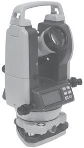
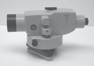
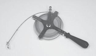
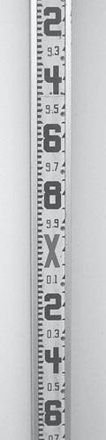
1-1. Traditional surveying instruments:(a) Theodolite (Courtesy of CST/Berger,Illinois),(b) level,(c) a level rod,and (d) a
The traditional measuring instruments used in the field are the transit or theodolite (to measure angles),the level and level rod (to measure vertical distances or elevations),and the steel tape (to measure horizontal distances).They are illustrated in Figure 1-1.The use ofthese types ofinstruments is described in detail in subsequent chapters.
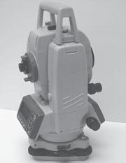
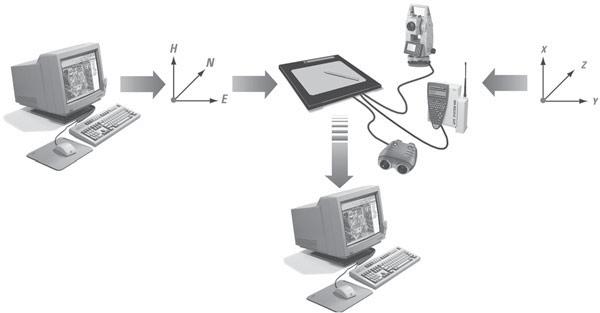
Electronic measuring devices have largely replaced traditional instruments in surveying field work.One ofthe most advanced ofthese modern instruments is the electronic recording tacheometer,or total station,as it is also called (see Figure 1-2a).It comprises an electronic distance measuring (EDM) device,an electronic theodolite to measure angles, and an automatic data recorder.Many companies provide a “field-to-finish”system (Figure 1-2 b ),complete with the
computer hardware and software needed to analyze and plot the survey data.
The total station and other modern instruments will be discussed again later on in the text.But the fundamental principles ofsurveying remain the same,whether the electronic or the more traditional instruments are used.The beginning student must still learn these basic principles before using sophisticated modern instruments.In any event,the steel tape, the transit,and the level are still used for many construction and small-scale surveys.In fact,we shall see later on that the steel tape is more accurate than most electronic devices when it comes to measuring relatively small horizontal distances.
With skillful use ofsurveying instruments and with proficient application offield and office procedures,almost
(a)
FIGURE 1-2. (a) An electronic total-station surveying instrument that can be used to measure and record distances and angles and compute coordinates.(Courtesy ofLeica Geosystems,Inc.) (b) In a field-to-finish system,data may be stored electronically.The data can be “dumped”into the office desktop computer for computations and plotting or printing.
FIGURE
steel tape.
any measurement problem can be solved.Conversely,it is difficult to solve any problem requiring relatively large and accurate measurements without resorting to proper surveying methods and instruments.
Importance of Surveying
Surveying plays an essential role in the planning,design, layout,and construction ofour physical environment and infrastructure.The term infrastructure is commonly used to represent all the constructed facilities and systems that allow human communities to function and thrive productively.
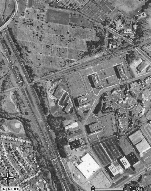
Surveying is the link between design and construction. Roads,bridges,buildings,water supply,sewerage,drainage systems,and many other essential public-works projects could never be built without surveying technology.Figure 1-3shows a bird’s-eye view ofa typical urban environment that depends on accurate surveying for its existence.Nearly every detail seen on that photograph was positioned by surveying methods.
In addition to its customary applications in construction and land-use projects,surveying is playing an increasingly important role in modern industrial technology.Some activities that would be nearly impossible without accurate surveying methods include testing and installing accelerators
FIGURE 1-3. Practically every line recorded on this photograph was laid out with a transit,a steel tape, and a level—the primary equipment ofthe surveyor.(Courtesy ofNew Jersey Department of Environmental Protection)
for nuclear research and development,industrial laser equipment,and other sensitive precision instruments for manufacturing or research.The precise construction of rocket-launching equipment and guiding devices is also dependent on modern surveying.
Without surveying procedures,no self-propelled missile could be built to the accuracy necessary for its operation.Its guiding devices could not be accurately installed;its launching equipment could not be constructed;it could not be placed in position or oriented on the pad;and its flight could not be measured for test or control.Moreover,its launch position and the position ofits target would be a matter of conjecture.Surveying is an integral part ofevery project of importance that requires actual construction.
1-2THE SURVEYING METHOD
The earth,ofcourse,is spherical in shape.This fact,which we take for granted today,was an issue ofgreat debate only a few hundred years ago.But despite the unquestionable roundness ofthe earth,most surveying activities are performed under the tacit assumption that measurements are being made with reference to a flat horizontal surface.This requires some further explanation.
Defining Horizontal and Vertical Directions
The earth actually has the approximate shape ofan oblate spheroid,that is,the solid generated by an ellipse rotated on its minor axis.Its polar axis ofrotation is slightly shorter than an axis passing through the equator.But for our purposes,we can consider the earth to be a perfect sphere with a constant diameter.In fact,we can ignore,for the time being, surface irregularities like mountains and valleys.And we can consider that the surface ofthe sphere is represented by the average level ofthe ocean,or mean sea level.
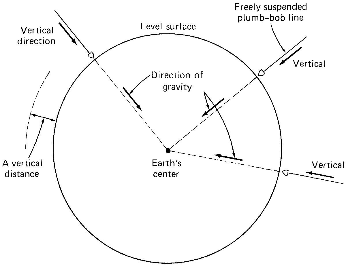
By definition,the curved surface ofthe sphere is termed a level surface. The direction ofgravity is perpendicular or normal to this level surface at all points,and gravity is used as a reference direction for all surveying measurements.The direction ofgravity is easily established in the field by a freely suspended plumb line,which is simply a weight,or plumb
FIGURE 1-4. The vertical direction is defined as the direction ofthe force ofgravity.
bob,attached to the end ofa string.The direction ofgravity is different at every position on the earth’s surface.As shown in Figure 1-4,the direction ofall plumb lines converge at the center ofthe earth;at no points are the plumb lines actually parallel.
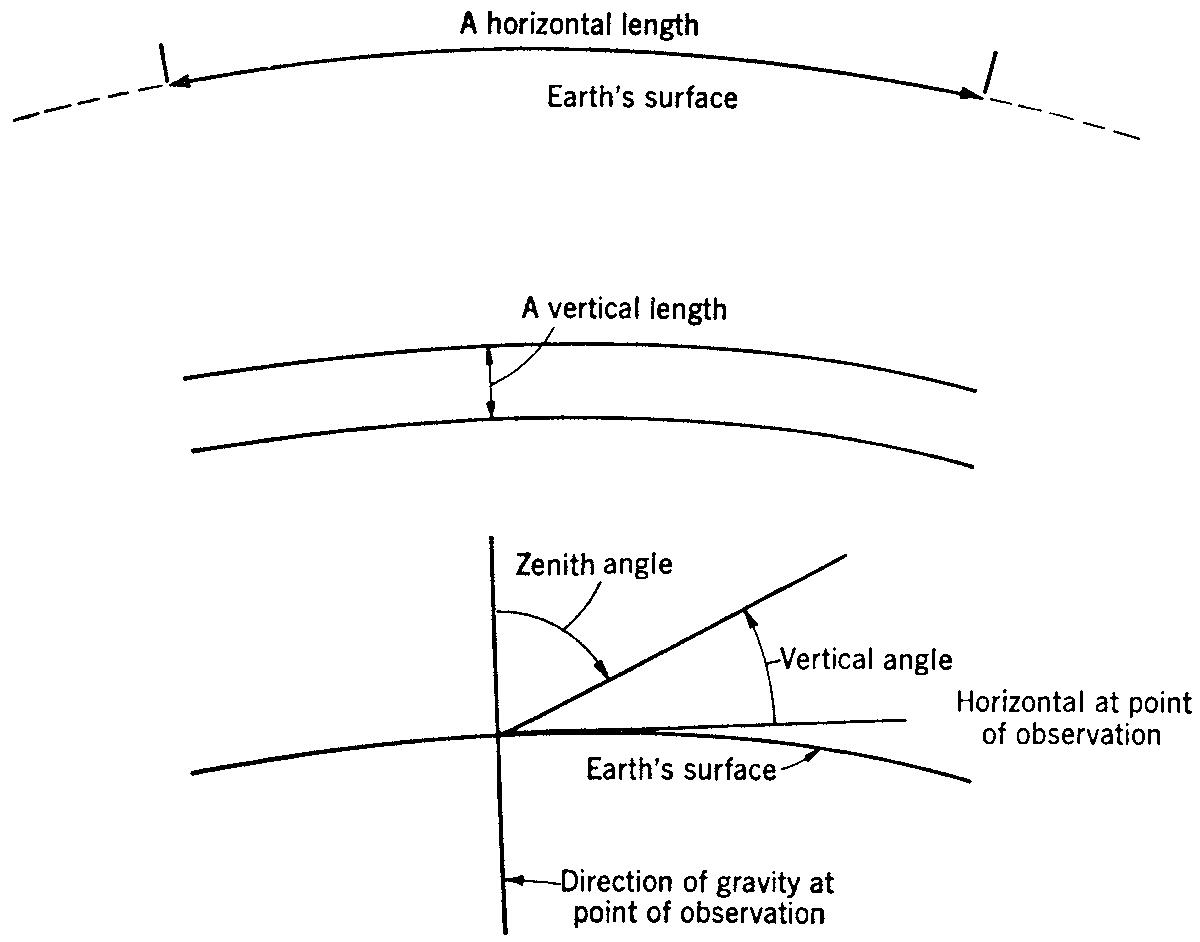
The vertical direction is taken to be the direction ofgravity. Therefore,it is incorrect to define vertical as simply “straight up and down,”as many beginning students tend to do.The vertical direction varies from point to point on the earth’s surface.The only common factor is the direction ofgravity. By definition,the horizontal direction is the direction perpendicular (at an angle of90°) to the vertical direction of gravity.Because the vertical direction varies from point to point,the horizontal direction also does.A horizontal length or distance,then,is not really a perfectly straight line.It is curved like the surface ofthe earth.This is illustrated in Figure 1-5.
FIGURE 1-5. A true horizontal distance is actually curved,like thesurface ofthe earth.
Measuring Distances and Angles: An Overview
As shown in Figure 1-5,a horizontal distance or length is measured along a level surface.At every point along that length,the line tangent to the level surface is horizontal. Horizontal distances may be measured by stretching a steel tape between a series ofpoints along a horizontal line.Electronic distance meters,which use infrared light waves and measure very long distances almost instantaneously,are also used.For most surveys,the curvature ofthe earth can be neglected,as will be discussed in more detail in the next section.Taping and the use ofEDM instruments are discussed in Chapter 4.
A vertical distance is measured along the direction of gravity and is equivalent to a difference in height between two points.When the height is measured with reference to a given level surface such as mean sea level,it is called an elevation.
Vertical distances are usually measured with wooden or fiberglass rods held vertically and graduated in centimeters or hundredths ofa foot.An instrument called a level is used to observe the rod at different points.A level consists ofa telescopic line ofsight,which can be made horizontal by adjusting an attached sensitive spirit bubble.The instrument can be turned in various directions around a stationary vertical axis.As shown in Figure 1-6,the difference in the readings on the rod at two points is equivalent to the difference in height or elevation between the points.
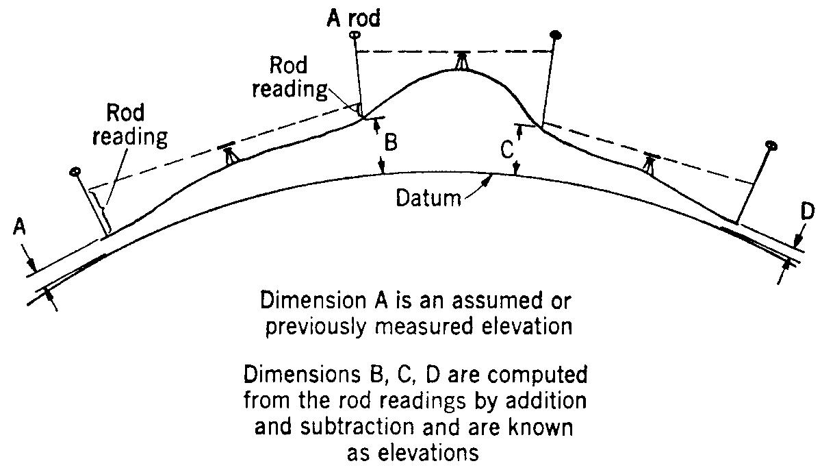
The relative vertical positions ofseveral points separated by long distances can be determined by a continuous series oflevel rod observations,as illustrated in Figure 1-7. This procedure is called leveling. The line ofsight ofthe level is horizontal at each observation.Because most level rod observations are made with relatively short line-of-sight distances (less than about 300 ft or 90 m),the effect ofthe earth’s curvature is not at all noticeable.This is explained more thoroughly in the following discussion ofplane surveying.In any case,proper leveling methods will compensate for the effects ofcurvature,as well as for possible instrumental errors.Leveling theory and field procedures are discussed in detail in Chapter 5.
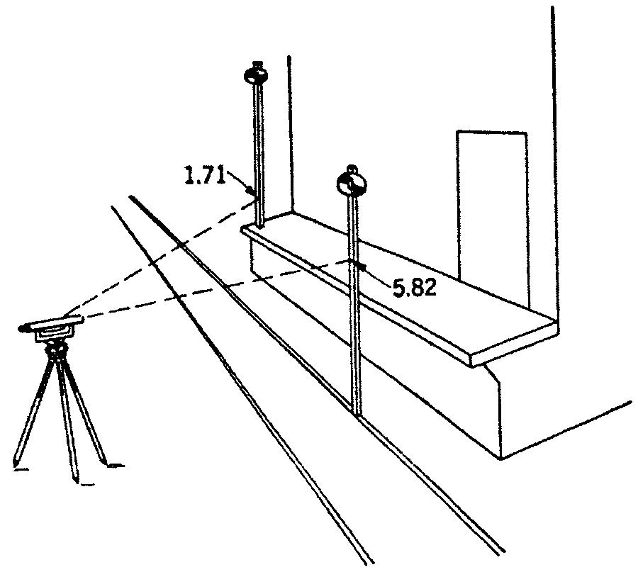
FIGURE 1-6. Measuring a difference in height between a rail and a platform.The difference here is 5.82 - 1.71 = 4.11 ft.
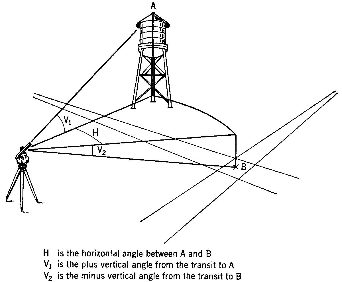
A horizontal angle is measured in a plane that is horizontal at the point ofmeasurement,as illustrated in Figure 1-8.When a horizontal angle is measured between points that do not lie directly in the plane,like points A and B in Figure 1-8,it is measured between the perpendiculars extended to the plane from those points.(Actually,angles are measured between lines,not points.We will discuss thismore thoroughly in the part ofthe book on angular measurement.)
A vertical angle is measured in a plane that is vertical at the point ofobservation or measurement.Either the horizontal direction (horizon) or vertical direction (zenith) may be used as a reference line for measuring a vertical angle.In Figure 1-8, V1 is the vertical angle between the horizon and the instrument line ofsight to point A,and V2 is the vertical angle between the horizon and the line ofsight to point B. Both vertical and horizontal angles are discussed in more detail in Chapter 6.
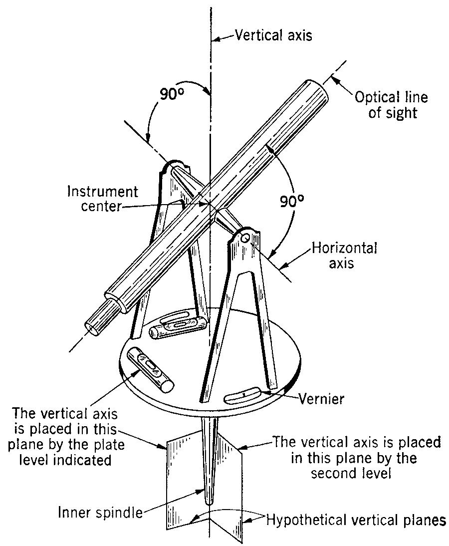
Horizontal and vertical angles are measured with an instrument called a transit or theodolite. This type ofinstrument consists essentially ofan optical line ofsight,which is perpendicular to and is supported on a horizontal axis.
FIGURE 1-7. The relative vertical positions oftwo or more points are determined by leveling.
Theodolites are generally finer in quality and performance (and are more expensive) than transits.
As shown in Figure 1-9,the horizontal axis ofthe instrument is perpendicular to a vertical axis,about which it can rotate.Spirit levels are used to make the vertical axis coincide with the direction ofgravity.Modern instruments use an electronic leveling system.In older instruments,graduated metal circles with verniers or glass circles with micrometers are used to read the angles.In modern theodolites,the circles
Measurement of horizontal and vertical angles.
are scanned electronically,and the value ofthe angle is displayed digitally.
Plane and Geodetic Surveying
We mentioned in the preceding section that most surveying measurements are carried out as ifthe surface ofthe earth were perfectly flat.In effect,this means that we make our measurements as ifthe lines offorce due to gravity were everywhere parallel to each other,and as ifunderneath the irregular ground surface there existed a flat,horizontal reference plane.This is illustrated in Figure 1-10.
The method ofsurveying based upon this assumption is called plane surveying. In plane surveying,we neglect the curvature ofthe earth,and we use the principles ofplane geometry and plane trigonometry to compute the results of our surveys.
The use ofplane surveying methods simplifies the work ofthe surveyor.And for surveys oflimited extent,very little accuracy is lost.Within a distance ofabout 12 mi,or 20 km, the effect ofthe earth’s curvature on our measurements is so small that we can hardly measure it.In other words,a horizontal distance measured between two points along a truly level (or curved) line is,for practical purposes,the same distance measured along the straight chord connecting the two points.In fact,over a distance ofabout 12 mi,the difference between the length ofarc and the chord length is only about 0.25 in.
This textbook is designed primarily as an introduction to plane surveying,which,for the reason described previously,is suitable for surveys extending over distances less than about 12 mi.But as it turns out,the vast majority of ordinary private surveys are performed well within these limits.Certain public surveys,however,are conducted by federal or state agencies and cover large areas or distances.
FIGURE 1-8.
FIGURE 1-9. Transit essentials.Schematic diagram ofan alidade, which is the upper part ofa transit.
Such large-scale surveys must account for the true shape of the earth so that the required degree ofaccuracy is not lost in the results.
A survey that takes the earth’s curvature into account is called a geodetic survey.These types ofsurveys are usually conducted by federal agencies such as the U.S.Geological Survey and the U.S.National Geodetic Survey.Various river basin commissions and large cities also perform geodetic surveys.Such surveys generally use very precise instruments and field methods and make use ofadvanced mathematics and spherical trigonometric formulas to adjust for curvature.In some cases,the instruments and field methods used in a geodetic survey do not differ from those used in a plane survey,but spherical trigonometry must always be used to reduce the geodetic survey data.
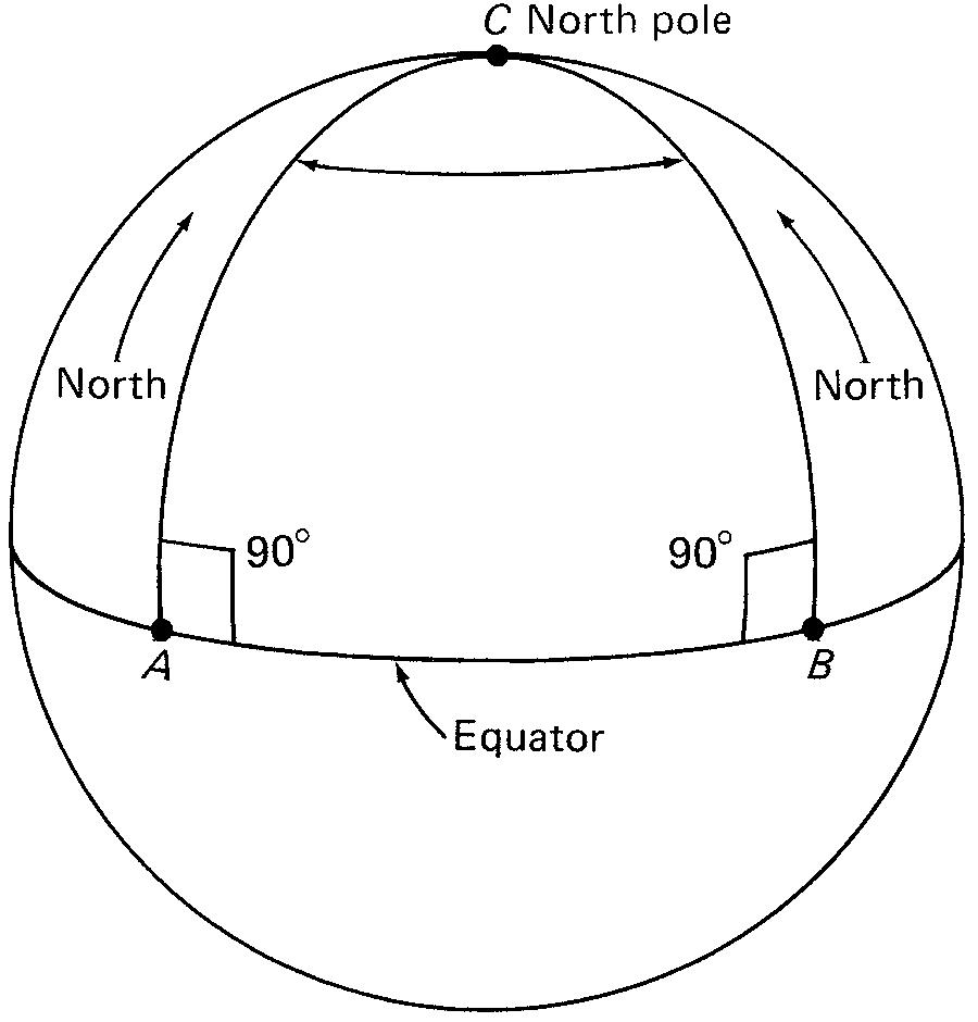
The geometry and trigonometry offigures on a curved surface differ considerably from the geometry and trigonometry ofplane or flat figures.For example,in a plane triangle,the interior angles always add up to 180°.But this is not the case with a triangle on a curved surface.The triangle shown on the sphere in Figure 1-11,for instance, must contain more than 180°.The sides ofthat triangle change direction by 90°at each corner, A and B ,on the equator.With angle C added to A and B,the sum is clearly more than 180°.Spherical trigonometry,then,takes into account the properties ofgeometric shapes on curved surfaces.
Geodetic surveying methods are generally used to map large areas and to establish large-scale networks ofpoints on the earth for horizontal and vertical control.The relative positions ofthese points are measured with a high degree of precision and accuracy,both in longitude and in latitude,* as well as in elevation.They are used as points ofreference for many other local surveys that require a lower degree of accuracy.
*Longitude is the angular distance ofa point on the earth’s surface,measured east or west ofthe prime meridian at Greenwich,England. Latitude is the angular distance ofa point on the earth’s surface,measured north or south ofthe equator.
FIGURE 1-10. In plane surveying, the curvature ofthe earth is neglected and vertical distances are measured with reference to a flat plane.
FIGURE 1-11. On a curved surface,the sum ofthe angles in a triangle is more than 180°.
1-3SURVEYING APPLICATIONS
As we mentioned at the beginning ofthis chapter,the two fundamental purposes for surveying are to determine the relative positions of existing points and to mark the positions of new points on or near the surface ofthe earth.
Within this framework,many different kinds ofsurveys are performed.Some specific applications or types ofsurveys are outlined briefly in this section and are discussed in more detail in Part 3ofthe text.Generally,these different types of surveys require different field procedures and varying degrees ofprecision for carrying out the work.
Property Survey
A property survey is performed to establish the positions of boundary lines and property corners.It is also referred to as a land survey, title survey,or a boundary survey. Property surveys
are usually performed whenever land ownership is to be transferred or when a large tract ofland is to be subdivided into smaller parcels for development.Also,before the design and construction ofany public or private land-use project can get under way,it is necessary to accurately establish the legal boundaries ofthe proposed project site.Constructing a structure on what later is found to be property that belongs to someone else can be a very expensive mistake.
Any survey for establishing or describing land boundaries must be performed under the supervision ofa licensed land surveyor.Land surveys in urban areas must be conducted with particular care because ofthe very high cost of land.In rural areas,less accuracy may be acceptable.Land surveys done to actually mark property corners with permanent monuments are sometimes informally referred to as “stakeout,”“outbound,”or “bar job”surveys.The results ofa property survey may be written into a deed or may be prepared as a drawing called a plat,as illustrated in Figure 8-2.
Topographic Survey
A topographic survey is performed to determine the relative positions (horizontal and vertical) of existing natural and constructed features on a tract ofland.Such features include ground elevations,bodies ofwater,vegetation,rock outcrops,roads,buildings,and so on.
A topographic survey provides information about the “shape ofthe land.”Hills,valleys,ridges,and the general slope ofthe ground can be depicted graphically.The data obtained from a topographic survey are plotted and drawn as a suitably scaled map,called a topographic map,or topo map. Figures 9-1and 9-2are examples oftopo maps.
The shape ofthe ground is shown with contours, or lines ofequal elevation.Because a topo map is always needed before the engineering and architectural design ofany building or other project can begin,a topo survey may also be referred to as a preliminary survey. Ofcourse,an accurate property survey must always precede the topo survey to establish the boundaries ofthe project site.
Construction Survey
A construction survey,also called a layout or location survey, is performed to mark the position of new points on the ground.These new points represent the location ofbuilding corners,road centerlines,and other facilities that are to be built.These positions are shown on a site plan ,which is essentially a combination ofthe property survey and topo survey,along with the newly designed facilities.This may also be called a plot plan.
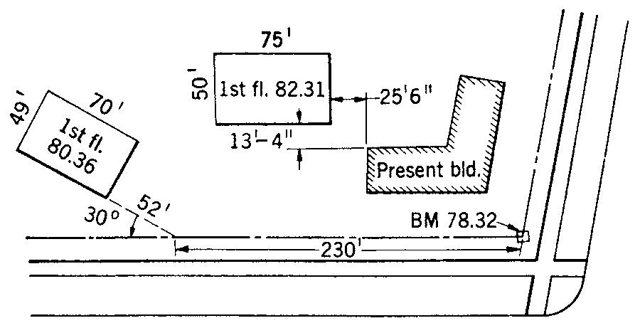
A site plan shows the location dimensions that are to be measured with reference to boundaries or other control points.Vertical heights are given by elevations.Sometimes horizontal positions may be given by coordinates.Wooden stakes are used by the surveyor to mark the positions ofthe buildings,roads,and other structures.An example ofa drawing that includes location dimensions is shown in Figure 1-12.
FIGURE 1-12. Typical location dimensions found on engineering or architectural plans,for use during a stakeout survey.
The wooden stakes serve as reference points for the construction contractor who actually builds the project.They may be centerline stakes,offset stakes,or grade stakes. Carpenters,masons,and other skilled trades transfer measurements directly from the survey points.The procedure of placing the markers is called staking out. Another term used, especially for pipelines and roads,is giving line and grade.
Control Survey
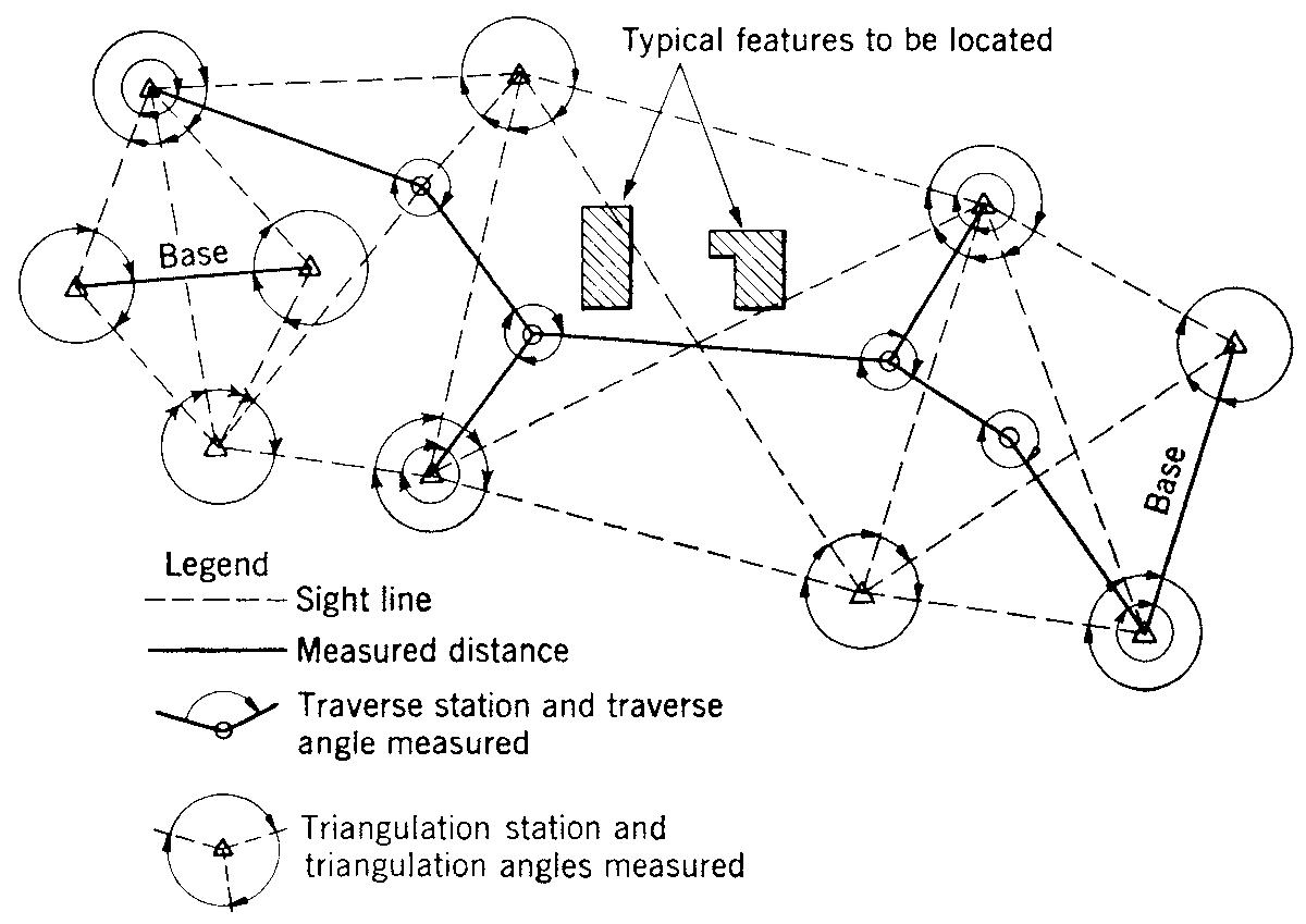
There are two kinds ofcontrol surveys:horizontal and vertical. In a horizontal control survey,several points are placed in the ground by the surveyor,using wooden stakes or more permanent markers such as iron bars and concrete monuments.These points,called stations,are arranged throughout the siteor area under study so that they can be easily seen and surveyed.
The relative horizontal positions ofthese points are established,usually with a very high degree ofprecision and accuracy;this is done using traverse or global navigation satellite systems (GNSS) survey methods.
In a vertical control survey,the elevations ofrelatively permanent reference points are determined by precise leveling methods.Marked or monumented points ofknown elevation are called elevation benchmarks (BMs).
The network ofstations and benchmarks provides a framework for horizontal and vertical control,upon which less accurate surveys can be based.For example,boundary surveys or construction surveys can be tied into nearby control survey stations and benchmarks.This minimizes theaccumulation oferrors and the cost ofmaking all the measurements precise.
Existing topographic features and proposed points or structures are connected to the control network by surveying measurements ofcomparatively low precision.A steel tape and a builder’s level may be used in some cases.An example ofa control survey network is shown in Figure 1-13.When local surveys are tied into a control survey,a permanent reference is established that can be retraced ifthe construction stakes or property corners are obliterated for any reason.
Large-scale or geodetic control surveys must account for the curvature ofthe earth in establishing relative horizontal and vertical positions.Geodetic control surveys include astronomic observations to determine latitude and longitude and the direction ofastronomical north.Modern
geodetic control surveys can be performed using signals from satellites,which are received by instruments called global navigation satellite systems (GNSS).
Route Survey
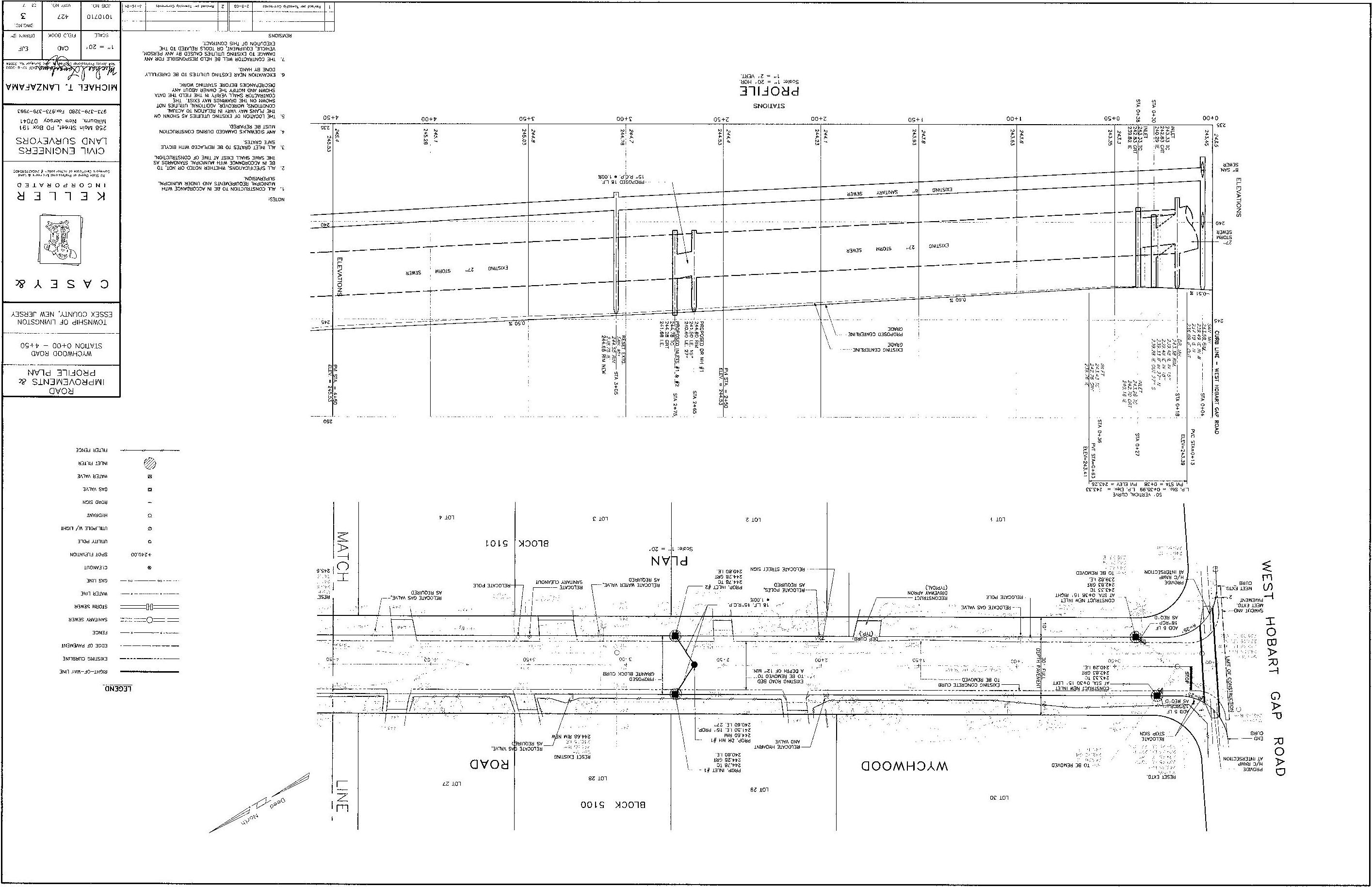
A route survey is performed to establish horizontal and vertical control,to obtain topographic data,and to lay out the positions ofhighways,railroads,streets,pipelines,or any other “linear”project.In other words,the primary aspect of a route survey is that the project area is very narrow compared with its length,which can extend up to several kilometers or miles.An example ofthe results ofa route survey—the plan and profile ofa proposed road—is shown in Figure 1-14.Plane geometry is used to compute the horizontal and vertical alignment ofthe road.
Other Types of Surveys
A hydrographic survey is a preliminary survey applied to a natural body ofwater.It serves to gather data for mapping the shoreline and for charting the water depths ofa river, lake,or harbor.In effect,an underwater topo map is prepared from a hydrographic survey.Navigation and water resources planning projects depend upon data obtained from hydrographic surveys.
A reconnaissance survey is a preliminary survey conducted to get very rough data regarding a tract ofland.Distances may be approximated by pacing,and spot elevations may be obtained with the use ofonly a hand level.Examination of aerial photographs may also serve as part ofa reconnaissance survey. Photogrammetric surveying uses relatively accurate methods to convert aerial photographs into useful topographic maps.A control survey on the ground is still necessary when utilizing photogrammetry to produce accurately scaled maps.
A cadastral survey is a boundary survey applied specifically to the relatively large-scale rectangular U.S.Public Lands Survey system.It also refers to the surveying and identification ofproperty in political subdivisions.
FIGURE 1-13. A horizontal control survey network showing traverse and triangulation stations (points) and courses (lines).
Other types ofspecialized surveys include mine surveys, bridge surveys , tunnel surveys ,and city surveys. Surveying applications also range from monitoring very small movements ofthe earth over long periods oftime (such as earthquakes and other geological studies) to tracking the orbits of satellites and space vehicles.
Surveying,an activity with roots in antiquity,is now a modern and continually evolving technical discipline and profession.
1-4HISTORICAL BACKGROUND
Surveying probably has its origins in ancient Egypt,as far back as 5000 years ago.Some type ofsystematic measurements must have been made,for example,to accurately and squarely lay out the Great Pyramid with respect to the true meridian (the north-south direction line).And the annual floods ofthe Nile River,which obliterated land boundary markers used for taxation purposes,made it necessary for ancient surveyors to relocate and replace the lost boundaries.
Those early surveyors used ropes that were knotted at uniform intervals to measure distance;the surveyors were, appropriately enough,called rope stretchers. The interval between the knots,called a cubit,was taken to be the length ofthe human forearm.The cubit,which,ofcourse,could vary depending on whose forearm was used to establish it, was the basic unit oflength used at that time.
It is likely that the subject ofgeometry (which means “earth measurements”) developed primarily because ofthe need to conduct surveys ofthe land.Since ancient times,historical records show the development ofsurveying as an applied science,one that evolved as measuring instruments, as well as computational methods,gradually improved.It is ofvalue for the beginning student ofsurveying to have at least a general perspective ofthis historical development. Students may wish to go to www.surveyhistory.org for images and explanations ofancient surveying tools.
1-14. A typical plan and profile ofa section ofroadway,prepared from route survey data.(Courtesy ofCasey & Keller,Inc.)
FIGURE
Perhaps the earliest device used to establish a level line was a triangular A-frame with a plumb line and weight suspended from the apex,called the libella. A mark at the center lower bar indicated the proper position ofthe plumb line for the bar to be horizontal.The position ofthe mark on the bar could also have been “calibrated”by aligning it with a free water surface.
Ancient Roman engineering accomplishments include roads,aqueducts,and buildings.One ofthe instruments used by Roman surveyors,who were called agrimensores (“land measurers”),was the groma. It comprised a pair of crossarms attached at right angles to each other and supported on a vertical staff.Plumb lines suspended from the end ofeach arm were used to establish perpendicular or right-angle lines ofsight.The Romans also used a device called a chorobate,a timber beam with a narrow groove on top to hold water,as a leveling instrument;the water surface established a level line ofsight.
The magnetic compass was first used as a surveying instrument in the thirteenth century to establish the directions ofboundary lines.By the beginning ofthe sixteenth century,a sighting device similar to the transit,with graduated scales to measure vertical and horizontal angles,was in use.It was improved considerably,in the middle ofthe seventeenth century,with the addition ofthe telescope and cross hairs for establishing a line ofsight.Also around that time,a device for reading small subdivisions ofa graduated scale was invented by Pierre Vernier.The vernier ,as it is called,is still used today to increase the accuracy ofreading angles on most traditional engineering transits.
The development and gradual improvement ofsurveying instruments continued through the eighteenth century, and the nineteenth century was one ofcontinuing refinement in field methods as well as in instrumentation.It was at the end ofthe eighteenth century that a systematic survey of the entire public domain in the United States was begun. This large-scale public land survey,as well as the construction ofrailroads and canals throughout the nation,led to many advancements in surveying procedures.
Several famous Americans,including George Washington, Thomas Jefferson,Daniel Boone,and the writer-philosopher Henry David Thoreau,earned their living as surveyors for a while.George Washington was licensed as a land surveyor by the College ofWilliam and Mary.Even Abraham Lincoln served briefly as a “deputy surveyor.”And the main character in the symbolic novel The Castle,by Franz Kafka,was portrayed as a land surveyor.
The surveying profession,then,has some notable associations with literature and famous personalities.Ofcourse,the study or practice ofsurveying will not guarantee us fame or fortune.But it is such a practical and down-to-earth subject that knowledge ofits basic principles can only serve an individual well,irrespective ofhis or her future career path.
Since the twentieth century,surveying has emerged as a dynamic and modern technical discipline.The two world wars,as well as the military conflicts in Korea,Vietnam,and the Middle East,have led to significant developments in
LAND SURVEYING
Of all kinds, according to the best methods known; the necessary data supplied, in order that the boundaries of Farms may be accurately described in Deeds; Woods lotted off distinctly and according to a regular plan; Roads laid out, &c., &c. Distinct and accurate Plans of Farms furnished, with the buildings thereon, of any size, and with a scale of feet attached, to accompany the Farm Book, so that the land may be laid out in a winter evening.
Areas warranted accurate within almost any degree of exactness, and the Variation of the Compass given, so that the lines can be run again. Apply to
Henry D. Thoreau
Facsimile ofa Handbill announcing Thoreau’s availability as a surveyor,circa 1850.
surveying technology.In fact,the use ofelectronics and computers in surveying is largely an offshoot ofwhat were, initially,military reconnaissance and mapping applications.
Nonmilitary needs for the inventory and management of natural resources,such as surface water and timberland,have also been a catalyst for advancements in surveying.And the increasing use ofaerial photography,GNSS,andphotogrammetric surveying is attributable to military as well as peacetime needs for large-scale and accurate surveys.
In the 1980s,the application ofspace-age technology to surveying practice began to accelerate rapidly,in what may be characterized as a technological revolution.Electronic instruments for distance and angular measurement,automatic data-recording devices,microprocessors for data reduction and computer mapping,laser-leveling devices, remote sensing and surveying ofthe earth by satellite photographs,and GNSS have all become a part ofcontemporary surveying practice.
But for now and for many years to come,the study of surveying must begin with the application oftraditional instruments,field methods,and computational procedures. These are still in use today.In any case,an understanding of traditional methods using the steel tape,the level and level
rod,the transit,and the handheld electronic calculator will provide a solid foundation for keeping up with the latest technological developments in the surveying profession.
1-5THE PROFESSION OFSURVEYING
A profession may be defined simply as a career activity that requires specialized training in a particular discipline or subject matter.A “professional”must acquire knowledge and skill beyond those ofthe craftsperson.For the so-called learned professions,such as medicine and law,an academic training comprising many years ofcollege education is generally required.Engineering,engineering technology, and surveying are also learned professional disciplines, although the extent ofrequired college preparation is generally less than that for medicine or law.
Professionals in any discipline must follow a code ofethical conduct that places regard for the safety,health,and welfare ofthe public above and beyond monetary considerations.
Surveying has long been associated with the profession ofcivil engineering.The planning,design,and construction ofbuildings and public-works facilities depend so heavily upon surveying activities that civil engineers and technicians,architects,and construction managers have always had to be skilled and knowledgeable in surveying principles and methods.And they will still have to be so in the future.But in recent years,surveying has emerged as an independent professional discipline,and the requirements for an appropriate college education in surveying are gradually increasing in the United States.
The Licensed Professional Land Surveyor
In addition to the requirement for specialized training,one ofthe hallmarks ofa true profession is that it provides a unique service for people and for society as a whole.To protect the public from possible harm when supposedly “professional”services are offered by unqualified persons, asystem ofprofessional Licensure laws has been established in each state ofthe nation.These laws are meant to safeguard the public welfare by ensuring that only qualified persons engage in offering professional services to the public.
To engage in the practice ofland surveying in any state, it is necessary to become licensed by the appropriate board ofprofessional engineers and/or land surveyors in that state. (In most states,licensure requirements for engineers and surveyors are encompassed under the same law.) A surveyor is then licensed to offer his or her services to the public as a professional land surveyor,or LS,in that state.A person who practices land surveying without a valid license can be fined or even put in jail.
It is important to note that these Licensure laws apply only to the practice ofland or boundary surveying,and not to construction surveying or any other activity that does not involve the marking or description ofproperty lines. According to the New Jersey State Board ofProfessional
Engineers and Land Surveyors,for example,the practice of land surveying includes “surveying ofareas for their correct determination and description,and for conveyancing,and for the establishment or reestablishment ofland boundaries and the plotting oflands and subdivisions thereof,and such topographic survey and land development as is incidental to the land survey.”
Employment as a surveyor,then,does not depend upon acquiring a license,as long as the work does not involve setting or measuring the positions ofproperty corners.Only a licensed LS,however,has the authority to sign and affix a seal to survey plats,plot plans,or other boundary descriptions.Most surveyors gain their first years ofexperience working under the supervision ofa professional land surveyor.Anyone who intends to establish a private surveying firm must,ofcourse,have an LS license.
The level ofeducation and work experience required to become licensed as an LS varies from state to state.It is generally necessary to have several years ofsurveying experience and an appropriate college degree,but many states allow the applicant to substitute additional years ofwork experience for the formal educational requirements.In an effort to upgrade the status ofthe surveying profession, there is a trend in some states to make the bachelor’s degree a definite and formal educational requirement.
Meeting the state requirements for education and experience qualifies the surveyor to sit for a written examination. The LS license is awarded upon the successful completion of the exam.Many states are adopting a uniform national LS examination.Most ofthe exam covers basic surveying principles,but a portion ofit focuses upon local land-surveying practice and laws,which vary from state to state.A surveyor who becomes an LS in one state can,depending on state law, obtain a license in many other states by the principle known as reciprocity ,without the need to take another written examination.
1-6FIELD NOTES
All surveys must be free from mistakes or blunders. A potential source ofmajor mistakes in surveying practice is the careless or improper recording offield notes. Blunders in field records can and must be avoided. The art ofeliminating blunders is one ofthe most important elements in surveying practice.
Naturally,a blunder in either a boundary or a layout survey may result in high costs for altering,or removing and rebuilding,finished construction.One ofthe most important rules for avoiding costly blunders in surveying work is to be neat,thorough,and accurate in recording the results of field measurements,sketches,and related observations.Also, the quality and appearance ofthe field notes are a direct reflection ofthe entire surveying effort.
The proper taking offield notes,then,is a very important skill for the surveyor,one that cannot be overemphasized.It may sound like a trivial task to an inexperienced surveying technician or student,but it generally is one ofthe more
elusive skills for the beginner.It takes much practice,patience, and concentration to be able to write legible notes and to record meaningful sketches in a handheld notebook,especially ifthe weather conditions are not the best.
It may seem easier to quickly jot down some figures and rough sketches on a scrap ofpaper in the field and,later on or the next day,in the comfort ofthe office,to copy the information neatly into a notebook. But this is just what must be avoided! Not only is the copying ofnotes a waste ofvaluable time but also it increases the chance for blunders to occur.A legitimate set ofsurvey field notes must contain the original data that were recorded at the time and place of measurement. (Sometimes,though,certain data may be copied from one set ofnotes for use in another survey,but the copied notes must be clearly marked as such.)
A survey party or crew might include three or four members,although two-person crews are more common with the use ofelectronic equipment.Even one-man crews are now possible with robotic or reflectorless total station instruments.Generally,one member ofthe field crew, usually called the party chief,is responsible for coordinating the survey and for recording the field notes.
An experienced party chieffully appreciates the need for neat,accurate,and thorough field notes.The notes are later used as the basis for office computations and plat or map preparation,often by a technician or engineer who was not at the project site during the survey.The notes obviously must be in a legible and organized form that allows for a clear and definite interpretation.
Often,field notes from one job are referred to,months or years later,in reference to a new job in the same vicinity.If the data were not properly recorded at the time ofsurvey,it is most unlikely that the party chiefor other crew members would remember the important facts and figures.And once in a while,the surveyor must present field notes in court,if, for example,there is a dispute over property lines.Obviously,incomplete,illegible,altered,copied,or otherwise improper field notes would not be suitable,or even acceptable,as legal evidence.
Field Notebooks
Most surveyors use a pocket-size,bound field notebook. These surveying field books have appropriate column and grid lines to guide the organized recording ofmeasurements. Field notes must be taken in a consistent and orderly form, as illustrated in Figure 5-23c;other illustrations oftypical field book records for distance and angular measurements are presented in appropriate sections ofthe textbook.
Some surveyors prefer to use small loose-leafnotebooks (particularly for relatively small surveys) so that the field records can be removed and kept in a single file folder for that particular job.A few surveyors may even use a pad and clipboard.The use ofloose-leafnotebooks or pads may present problems,though,with respect to lost sheets or to validity as evidence in court (since “cooked-up”notes can easily be inserted into the record).
Rules for Field Notes
1. Record all field data carefully in a field book at the moment they are determined. The note keeper must never allow any member ofthe field party to call out numbers faster than they can be accurately and neatly written down.
2. All data should be checked at the time they are recorded. Ifpossible,two members ofthe field crew should take the same reading independently.The note keeper should call out the recorded number so that the field party can hear it for verification.
3. An incorrect entry of measured data should be neatly lined out and the correct number entered next to or above it.This is particularly important ifthe notes ever have to be used in court as legal evidence.
4. Field notes should not be altered,and even data that are crossed out should still remain legible.Some surveyors will erase mistakes in descriptions or numerical computations (but not measurements) and neatly rewrite the correct information.In general,though,it is best never to erase a field book entry.
5. Original field records should never be destroyed,even if they are copied for one reason or another. It is unpardonable to lose a field book.
6. A well-sharpened medium-hard (2H to 4H) pencil should be used for all field notes.All entries should be neatly printed.
7. Sketches should be clearly labeled,including the approximate north direction.Do not crowd sketches together on a page.Although not drawn to scale,freehand sketches should be proportional to what is observed in the field.When possible,use a straightedge and circle template.
8. Show the word VOID on the top ofpages that,for one reason or another,are invalid;put a diagonal line across the page.Show the word COPY on the top ofcopied pages.
9. The field book should contain the name,address,and phone number ofthe owner,in ink,on the cover.At least one page at the front ofthe book is reserved for a table ofcontents.Pages should be numbered throughout the field book.
10. Each new survey should begin on a new page.The lefthand pages ofthe book generally are used for columns ofnumerical data.The right-hand pages generally are used for sketches and notes.
11. For each day ofwork,the project name,location,and date should be recorded in the upper corner ofthe right-hand page.The names ofthe crew members and their duties should also be recorded.
12. It is good practice to record the instrument type and serial number,as well as the weather conditions on the day ofthe survey.This information can be helpful when it is necessary to adjust for instrumental or natural errors or to judge the accuracy ofthe survey.