
12 minute read
Destinos


Title text
by name by William Duckwall
Advertisement
Route 32 From San José – Part Two
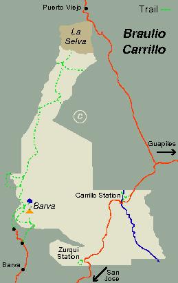
Continuing on Route 32 from where we left off in the last issue, our next destination is Braulio Carillo National Park. Driving from San José, it should take about an hour to drive the 42 kilometers to the ranger station. Traffic, weather, and road construction can conspire against you, but WAZE can give some advance warning of what lies ahead. There is even a Facebook page for this stretch of highway – just Google ruta 32 Facebook. First destination – Braulio Carillo National Park The highway starts in San José as Calles 1 and 3. It quickly becomes a four-lane divided highway that extends as far as the bridge over Rio Virilla, near Tibas. From there on it is a two-lane highway with an occasional third lane for passing. The Rio Virilla Bridge is now being widened to four lanes, and presumably the highway will also be widened in the future, at least for the section that goes up to the pass. The road climbs 450 meters from San José to the pass at 1,600 meters. Just before the pass is a toll station for northbound traffic (toward the Caribbean) – 250 colones for autos. Near the pass the highway enters Braulio Carillo National Park. Everyone wonders – whose idea was it to put a highway through the middle of a national park? The answer is complicated. There was a long-standing desire to have a road from San José to Guapiles (today’s Route 32 cuts an hour off the travel time to Siquirres, compared to the old Route 10 through Cartago and Turrialba, a road which is prohibitively twisty for large trucks). The original advocate for a roadway was none other than Braulio Carillo Colina, the third head of state of Costa Rica, for whom the park is named. Around 1840, Camino Carillo was begun, but was beset by one problem after another. In 1881 President Tomás Guardia Gutiérrez opened an improved road, but it was abandoned in 1891 when the railroad to the Atlantic was completed. Planning of today’s Route 32 began in 1977. Concern over the mostly unspoiled forest prompted lobbying efforts by conservation groups, which led to creation of the national park in 1978. Subsequent acts over the
years have expanded the park, and it is now the largest of the national parks, and perhaps the least developed. Construction of Route 32 was completed in 1987. Completed is a slippery term. Driving the road today you might believe it is still under construction. Frequent landslides and repaving, brought on by four to five meters of
yearly rainfall (156-195 inches) ensures that Route 32 will always be a work in progress. When a section is repaved, the last step is to repaint the lines. Unfortunately, the lining of the pavement sometimes lags traffic resumption by weeks or months. This is nerve-wracking in threelane sections where the center lane is a passing lane for uphill traffic – or sometimes for downhill traffic. When in doubt, avoid the center lane, or at least tuck in behind the biggest truck you can find. The same advice applies if you find yourself on Route 32 on a rainy night – get behind a nice big truck. One additional tip – when anyone breaks down and gets stuck on the roadway (almost always going uphill), it is common practice to lop off some branches and put them on the road fifty or a hundred meters before the stoppage. So, if you encounter branches in the road, it may be a warning of trouble ahead. (Perhaps adding a machete to the emergency kit in your trunk is a good idea.) Forty kilometers from San José, Route 32 comes to a long bridge over Rio Sucio. (Sucio means dirty – the river looks like it is muddy, but that’s not the whole story. The water is mineral rich and there are strains of bacteria that thrive in it, so much of the muddy appearance is due to the bacterial mat covering the streambed. The bridge marks the end of the worst section of the twisty steep descent. After two more kilometers you will arrive at the park ranger station, which comes up suddenly on the right. There is a sign, though you could miss it if you are focused on traffic. Braulio Carrillo National Park is huge, around 50,000 hectares (124,000 acres). There are trails at the Barva entrance, including a long trail that takes three or four days to traverse, ending at the La Selva research station, 9,400 feet lower than Barva. But for now I’ll focus on the two short trails (one or two km in length) starting at the Quebrada González Ranger Station, shown on the map as the Carrillo Station.
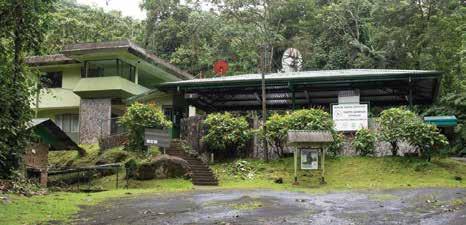
Braulio Carillo National Park – Quebrada González Station http://www.costarica-nationalparks. com/brauliocarrillonationalpark.html The park is open daily, 8 a.m.-4 p.m. There is an entrance fee of $12 for foreigners or 1,000 colones for residents and nationals. With payment of the fee, the ranger will offer you a trail map and perhaps advise you of what’s been sighted lately.


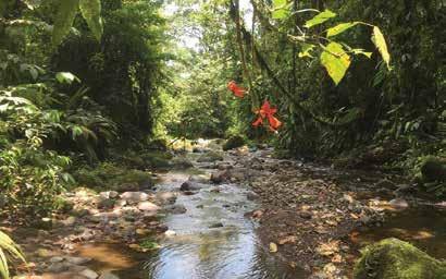
Sendero Ceiba is the shorter of the two trails. It starts across the highway – look for the small wooden gate. The trail is well maintained, mostly a gravel path with only a few steps. You could surely walk it in twenty minutes, but please, slow down and take time to absorb the surroundings. Your first impression may be, if you are a norteamericano, that houseplants have taken over – not surprising, since many of our houseplants originated in Central America. The trail passes by a good-sized ceiba tree, ceiba pentandra, also known also as the kapok tree. There are several species of kapok trees and all enclose their seeds in cottony fibers – kapok – thus the name. It is an emergent tree, meaning that at maturity it rises above the surrounding forest canopy. Ceibas can reach a height of 240 feet. They have huge buttress roots, though they are shallow. It is a wellknown tree in Central America, turning up on flags and in folklore, with some individual specimens known by name in the same way that California has its General Grant (a giant sequoia). The second trail, Sendero Las Palmas, goes up the hill from the upper parking lot, initially paralleling the stream Quebrada González. This trail has some steep uphill sections at the start and, consequently, a steep downhill stretch at the end, with lots of steps going up and down. The
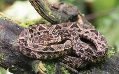
trail is well maintained though, and should give no trouble to reasonably fit walkers. Anyone with mobility issues might want to stick with the Sendero Ceiba trail. My wife and I visit this spot often; we live nearby so it’s perfect for a morning walk and a good spot for visitors who want a look at lowland rainforest. We’ve seen many sloths, been scolded by white-faced capuchin monkeys, and startled by a collared peccary barreling up a hillside. The area is amply supplied with leafcutter ants, butterflies, frogs, lizards, snakes, and insects. According to Wikipedia, there are over 600 species of trees, 500 species of birds, and 135 species of mammals (mostly bats) within the park. The critters are secretive, so don’t expect to see everything on one visit; they operate on their own schedules. I’m no botanist, but I do like plants and I’m fascinated by the variety of palms and ferns seen along the two short trails. There are ferns growing in the ground, on trees, as vines up trees, and ferns doing their best to be trees, some of them quite tall. Palms are equally diverse. The task of identifying 600 different species of trees seems just about impossible (maybe if I had started when I was fifteen), but getting fifty species of palms straightened out might be doable. For a photographer, plants have a huge advantage over animals – they stay put.


Final notes. Daytime temperature is usually in the 80s. The humidity is always near 100%, and there’s no breeze down on the forest floor. There are a few mosquitoes, so carry repellent. (You won’t need it much as long as you’re moving, but if you stop to fiddle with a camera, they’ll find you.) The trails are well kept; sneakers are good enough. Even the longer trail will take less than an hour so there’s no need to carry water, but taking a rain poncho or an umbrella with you is always a good idea. There are restrooms, picnic tables, and good spring water at the ranger station. Many national parks have guides on hand to help find and identify animals and plants along the way. The Quebrada González station has no guides; the trails are short, and there aren’t many visitors. If you’d like a guided walk (plus a host of other activities), you only have to drive down Route 32 another 3.2 km (2 miles) to the Rainforest Aerial Tram. Second Destination – Rainforest Aerial Tram https://www.rainforestadventure.com/pages/cratlantic-packages The Rainforest Aerial Tram is on the right side of Route 32 as you drive down the hill. There are several large signs along the shoulder announcing the spot
and its attractions. The grounds are outside Braulio Carillo, but so close that the flora and fauna are basically the same. The operation offers something for everyone, and is perfect for groups with a range of ages and interests. All the activities can be booked in advance – see the website above. The place is a real gem, but often overlooked because tourists think they need to drive farther to find wild Costa Rica. The grounds encompass 475 hectares (1 hectare = 2.47 acres). The business opened in 1994 after twoand-a-half years of construction. There had been some small landholders there before, but they were all moved down to the Rio Frio area, a better (and flatter) place for agriculture. The company organized lessons in English and natural history for some of the workers who built the park, and they in turn became the first guides. The aerial tram was the first draw at the park, but there are several other tours and activities today. All tours are guided, and all the guides I’ve encountered there have been terrific. They’re knowledgeable, entertaining, and enthusiastic about showing the rainforest to visitors. They find things that I would never have noticed on my own.
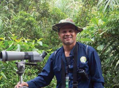
Our birding guide Celimo Rojas
Activities at the Rainforest Aerial Tram include: • Aerial tram – a gondola ride (up to six people plus a guide) with views of the forest from ground to treetop (two and a half hours) • Bird watching tours – Half-day (four hours) and full-day (seven hours) • Guided hikes – Short (two and a half hours) or fullday (seven hours) • Zip line – A series of eleven lines – the longest is 700 meters (two-and-a-half hours) • Frog tour – A guided night walk in the lodge area (two hours) Prices for the tours range from $34 per person for the shorter tours, to $89 for the longer ones. Included with many of the activities are a butterfly enclosure, a snake exhibit, and numerous local orchids on display. There are also a handful of small deluxe cabins, collectively called the Tapirus Lodge. We stayed here for a night fifteen years ago with our two sons. The cabins were rustic back then, and there were rows of whip scorpions lined up under the decks of each cabin. They aren’t really scorpions, they can’t sting, and they eat cockroaches. I wish I’d known all that back then; we slept with the window firmly closed, making sure the nightmarish arachnids stayed outside. But forget all that; today the cabins are new and beautifully furnished. If you stay there for a night, do consider the frog tour. Last fall we returned and revisited the tram ride, fifteen years after our first visit. Things have grown in that time; the tram is the same, but the trees along the line are much bigger and closer now. Our guide was Miguel Delgado, who filled us in on the history of the park, as well as pointing out more animals and plants than I can list. It turns out we live close to Miguel, and we have since
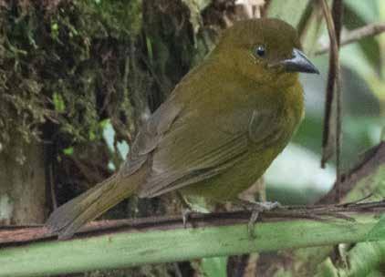
Birders are always excited about seeing a new species, even little fellows like this olive tanager
met his family – including his 12-year old son, who walks around looking into every tree and under every leaf, just like his father. After our tram ride, we got coffees and took a break at the restaurant. While we were there, a young tapir wandered by – the first tapir I’d ever seen in the wild. That topped off our visit. In January we returned once more, this time for the halfday birding walk. We thoroughly enjoyed it, though by the end of the day we were beat. Our birding guide was Célimo Rojas, who is one of the original construction workers, and who subsequently became the first guide for the property. The birding tours are fairly serious – it’s a good choice if you’re working on your life list of birds, or think you might want to, but it might be overkill if you just want to see some toucans. Bring good binoculars. I saw a number of species for the first time; the highlight for me was a brightly colored broad-billed motmot that we saw at close range. Célimo knows all the local birds, their calls, their flight patterns, and the subtle differences between related species. The tram property is well-known to serious birders; a few years ago it was a major hotspot, with visitors from around the world arriving to view the first known nest of a yellow-eared toucanet, which was conveniently located in a tree cavity facing the main road on the property. Next Issue – We’ll head farther north to a pair of eco-lodges and some nearby attractions, with something special for gardeners, and yet another treat for chocolate lovers. William is a retired engineer who lives in Guapiles with his wife Janet. He has varied interests – Costa Rican birds and orchids – and writes a little now and then. He can be reached at: bduckwall@mac.com
To
from ship
HERE
HERE to call SHIP TO COSTA RICA
shiptocostarica@ship506.com


Partial or Full containers directly door to door from Canada and USA to Costa Rica. We pickup palletized shipments all over the USA Cars - Boats - Motorcycles - Quads - ATV's - Equipment - Lumber - Prefab Homes. Moving back to the USA? We do that too! We are logistics consultants.


