
7 minute read
4.2 Syndicate Dunes

Syndicate Dunes Park proved to be a challenge for our team. The Van Buren trails to the Porter Legacy Dune trails became a nearly demanded a creative approach: the park’s close proximity to the Syndicate Dune Park neighborhood and the exceedingly steep dune topography in the region. The only existing and reliable path over the dune is designated as an ATV path. With much of the other parts of the dunes being virtually impassable due to their steepness, it was challenging to conceive of accessible routes.
After collecting more data on viable routes over the dunes and consulting with a Syndicate Dunes Park resident, we settled on a
Advertisement
20th ave, Fire LN N, and Grand BLVD around the easterly side of the neighborhood, avoiding the majority of residential properties. The second trail option would go over the least steep section of the dunes avoiding both the ATV path and the steepest parts of the dune. A conceptual design of a stair system was created by the team to help make the syndicate dune trail option both more accessible and less erodible. We suggest that posts similar to those shown in beach section to ensure that users do not lose their way in eas that
During our October visit to the site, the team found an already existing trail just north of the Dunes that leads from the beach to the Dune Overlook Loop in Porter Legacy Dunes. We incorporated the two Syndicate trail options to the Porter Legacy Dune Trail found connection trail that led to an opening in the woods with an optimal view of the Syndicate Dunes. We included this location in connecting the Porter Dune Trail to the Syndicate Dune Trail is a work in progress and we are exploring other options. One possible solution would be for Van Buren County to acquire the remaining undeveloped parcels within the dune area which would reduce the chances of unintentional trespassing from trail users. Additionally the county could seek to acquire parcels north of Grand Boulevard that border the Porter Legacy Dunes property line. This could create a public easement between the two properties that could be accessed from the road system.

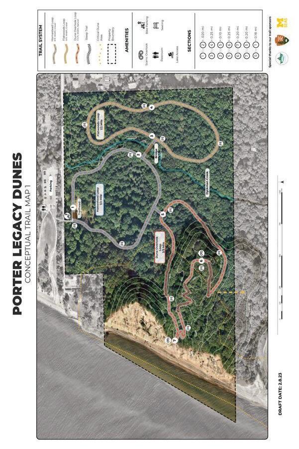
4.3 Van Buren State Park
The 400 acre Van Buren State Park is the most developed and heavily visited property within the Legacy Dune Trail System. The park is an ideal point of entry for the system due to the abundant parking, direct access to the lakefront, restroom facilities and ample sites for camping. The site can be safely accessed by regional non- the city of South Haven and Hartford. At the time of our team’s study, park managers are developing a new management plan for the state park. The trail concept described here along with trail marker recommendations will serve as a useful guide and starting point for future trail developments. This plan for Van Buren State Park remains a high level concept and further ground truthing and analysis would be required before trail construction could begin. This concept is intended to map out the general trail layout that will provide users with a compelling and engaging experience as they traverse the unique habitats, natural resources and topography of the area. users will begin their experience by ascending nearly 60’ from the parking into the dense forested backdune. From there a more gently sloped trail meanders for about ½ mile to the trail marker #2. From designated dune overlooks and hike along the ridge of the dune. Hikers can choose to travel down to the beach or continue along the trail. We also suggest the use of marker posts along this section (Figure 35). Trail Marker #3 connects with an existing trail network that crosses unique human developments including a historical abandoned mansion construction site. Trail marker #4 connects with the well developed North Point County Park trail system that currently is a popular entry point into the dunes. The design suggests improvements to the existing parking area by providing bike parking as well as a new vault toilet and changing room for visitors.
4.4 Legacy Dune Trail
Pilgrim Haven, Porter Legacy Dunes, Syndicate Park Dunes and Van Buren State Park is the Legacy Dune Trail. This 3 mile trail our survey results (1.5-3 miles). Easy access from car and nonmotorized transportation is provided by two designated vehicle and bike parking areas on the north and south ends. There are three additional trail entry locations with parking located along Ruggles road next to the State Park. Additional bike parking is proposed at the North Point Park entrance that is conveniently located near the midpoint of the trail. Adventurers can choose to hike the entire length of the trail or complete the trail in segments. This is made possible by the inclusion of 5 entry and exit points dispersed throughout the length of the trail. The multiple entry points also allow for easy access throughout the trail in the case of an emergency or injury on trail. Other important amenities incorporated throughout the trail system are benches and restroom facilities which were listed as some of the top amenities that visitors want when visiting the parks.

Lake access is a huge draw for tourists in the area, and Pilgrim lake. We anticipate that many visitors will wish to combine these activities especially during warm weather. To our surprise, hiking, walking and running was the most popular activity for both Van Buren and Pilgrim Haven with over 84% of respondents listing that as a primary activity. Based on the survey feedback we anticipate that this trial will be a popular attraction for regular park patrons lake Michigan from high points was the most desired amenity for
Considering that the average age of respondents was over 50 years old, it was important to design the trail system to be as accessible as possible. The team used GIS modeling and site analysis data to design a path through the varied topography that maintained minimal trail slope angles and reduced unnecessary grade changes. This was a unique challenge due to the steep dune topography however it was important to design this trail to be as inclusive to section where a wheelchair accessible boardwalk will allow visitors to traverse a gentle slope to a platform overlooking lake Michigan from nearly 70’ above. trail to help users navigate the space and make decisions based on section distance. At each trailhead there is a kiosk with a detailed map which provides information related to trail amenities, trail distance, topography, trail material and general trail width. Throughout the trail are numbered trail intersection maps which provide smaller maps that correspond with the property of which they are located. The numbered maps are strategically placed along major intersections of existing trails. More details related to the Signage Section.
4.5 Wayfinding and Interpretive Signage
a successful trail system. We were tasked with providing a strategy
4.5.1 Wayfinding System
is the process of determining and following a path or route between strategy we created includes trailhead kiosks, trail intersection signage, trail blazers, and dune posts. Best practices for map, signage design, and placement were developed based on a literature review. Key takeaways include:
Information that can be included directly on the map is preferred over information on map legends
Black and white maps are acceptable, but color maps can improve map feature discrimination (such as water) every junction
Maps should be mounted matching the orientation of the trail as opposed to cardinal directions
Maps should be regularly updated known as a YAH map
The trailhead kiosk for Porter Legacy Dunes will be placed at the crosswalk that will connect the site to Pilgrim Haven (Figure #). The kiosk contains relevant information about PLD as well as the interdunal trail. The maps will include information related to the trail distance, material, width and slope percentage. Based on that information trail users are equipped to make decisions about which routes to choose based on their own physical ability and preferences. The kiosk maps will also include information related to amenities within and nearby the property including points of including a full extent of the Legacy Dune Trial so users can gain a sense of their location within the entire trail system.
Trail intersection signage should be placed at every junction along the trail (Boon Kee and Smith-Jackson 2004). The signs we designed include the name and color code of each of the trails intersecting at the junction as well as information about the location and direction of amenities such as parking and restrooms (Figure #). Junction numbers should also be placed on each sign post (Boon Kee and Smith-Jackson 2004). Maps placed on signposts should be oriented with the trails as opposed to cardinal directions (Smith 2006). Ideally the maps are placed so that when read on the trail they are in line with the direction the visitor is facing. For example if the visitor is facing due west, then the trail map should be oriented so that west is facing up. (Kaplan, Kaplan, and Ryan 1998, and right on the vertical map corresponds with left and right on the ground. When a map is not aligned with the direction in front of the user then it is contraligned; maps oriented in this way have proven to be confusing and can send users in the wrong direction (Levine 1982). Another feature that improves map legibility is a “You are here” marker which shows the position of the trail user on the map with a line indicating the on the ground orientation of the map post on the map itself. (Levine 1982). For safety Protruding objects under 80” overhead including signage cannot extend more than 4” into the width of the path. This reduces overhead hazards for visitors paying attention to other things and those who are blind or have low vision. (Zeller, Doyle, and Snodgrass 2012).

SWMLC uses prefabricated trail blazers by Voss Signs on their properties. Blazers can be an important navigational tool, but they may not be universally understood by novice hikers or international visitors. To help with recognition, blazers should match the color of the trail they belong to (Boon Kee 2002). Having them screen printed with the name of the trail can also help to make their message clear (Figure 34). In the open dune portions of the trail, wooden posts can be driven into the ground trailside and their tops painted to match the color of trail, similar to those at John Dellenbeck Dunes in Oregon (Figure 35).


4.5.2 Interpretive Signage

Interpretive signage is a great way to increase access to the dune trail experience to those who are unable or do not desire to complete the full trail. By providing information that highlights the attraction that is both experiential and educational. Our strategy proposes using two types of signage: large, informational signs across the site, the color scheme for interpretive signage uses the sampled from photographs taken on site.


