


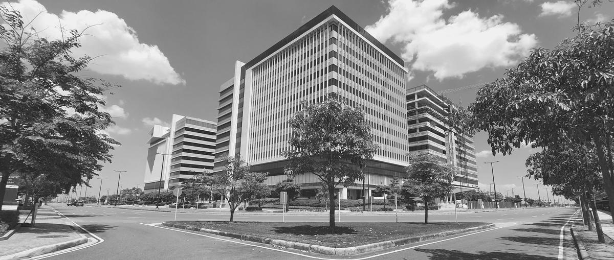


ARTHQUAKE LAHARLOW FLOODNG TSUNAM CATALYST STRATEGIC HIGH ELEVATION DISASTER-RESILIENT BACK-UP CITY FOR NATIONAL GROWTH PEOPLE CENTRIC NEW CLARK CITY
As “Clark” refers to the four districts it covers–Clark Freeport Zone, Clark International Airport, Clark Global City, and New Clark City– the whole branding process was inspired to highlight each district’s contribution to the modern city experience, while at the same time uniting them under one umbrella to present a new Clark identity. The new personality stands for efficiency, things and processes that work, convenience for its inhabitants, and ease of doing business for all locators.


NEW CLARK CITY THE SITE CHALLENGE
The future development shows a lack of affordable housing provision, mixed-use planning and walkable neighborhoods, adequate streets and lack of baseline data upon which to base strategic planning. The city proposes a development that is not linked to population growth and lacks strategy on how new public infrastructure will match the needs of the new residents in the city. There is also unclarity of how the new development will integrate the existing population living in the planned area for development. Strategic planning is significantly hampered by a governance system that includes many different actors involved in the planning and design of the area but which lacks a solid common framework that guides the development.

15°20'41.5"N 120°31'43.9"E
CONTENT
CIRCULATION ANALYSIS USER ANALYSIS ZONING ANALYSIS AUDITORY ANALYSIS NATURAL FACTOR AESTHETIC FACTOR CULTURAL FACTOR
CIRCULATION ANALYSIS
ROUTE MAP ANALYSIS ACCESIBILITY ANALYSIS
TO TARLAC CITY ENTRY TO O'DONNELL RD.

ROUTE MAP ANALYSIS
The site is located in Capas, Tarlac, within the planned unit development of New Clark City. It stretches from O'Donnell Road to NCC- SCTEX Access Road and is bounded to the west by the Clark Airport- NCC Access Road. The site can be easily accessed by its neighboring places such as Bamban, Tarlac City and Conception, Tarlac. Additionally, the Clark International Airport- NCC Access Road provides lesser point-to-point travel time that gives the user an easier access to the site


C L A R K A I R P O R TN C C A C C E S S R D R P O R TN C C A C C E S S R D
TO CLARK INTERNATIONAL AIRPORT N C C - S C T E X A C C E S S R D . N C C - S C T E X A C C E S S R D . N C C - S C T E X A C C E S S R D .
TARLAC SCTEX-NLEX INTERCHANGE
TO BAMBAN,
LEGEND NCC TRANSPORT HUB NCC NGAC TEMPORARY TERMINAL ROAD ROUTE
TO TARLAC CITY ENTRY TO O'DONNELL RD.
VEHICULAR ACCESIBILITY

The site is located in Capas, Tarlac, within the planned unit development of New Clark City. It stretches from O'Donnell Road to NCC- SCTEX Access Road and is bounded to the west by the Clark Airport- NCC Access Road. The site can be easily accessed by its neighboring places such as Bamban, Tarlac City and Conception, Tarlac. Additionally, the Clark International Airport- NCC Access Road provides lesser point-to-point travel time that gives the user an easier access to the site
TO BAMBAN, TARLAC SCTEX-NLEX INTERCHANGE
C L A R K A I R P O R TN C C A C C E S S R D C L A R K A I R P O R TN C C A C C E S S R D TO CLARK INTERNATIONAL AIRPORT N C C - S C T E X A C C E S S R D . N C C - S C T E X A C C E S S R D . N C C - S C T E X A C C E S S R D .
LEGEND MAINROAD SERVICE
CYCLEWAY
ROAD
USER ANALYSIS
USER PROFILE
LEGEND RESIDENTIAL GOVERNMENT ATHLETES
USER ANALYSIS

STUDENTS LOCALS ATHLETES BUSINESSMEN NATIONAL GOVERNMENT
ZONING ANALYSIS
LAND - USE ANALYSIS
EXISTING FACILITIES
LAND-USE ANALYSIS


1KM THESITE
LEGEND PASSIVE RECREATIONAL ZONE COMMERCIAL ZONE EDUCATION ZONE GOVERMENT AND INSTITUTIONAL ZONE ACTIVE RECREATIONAL ZONE INDUSTRIAL ZONE MIXED-USE RESIDENTIAL ZONE HIGH DENSITY RESIDENTIAL ZONE MEDIUM DENSITY RESIDENTIAL ZONE SOURCE: 2022 New Clark Primer
OPPORTUNITIES
The zoning is effectively divided to balance the development of structures and the construction of spaces that safeguard natural resources.
CONSTRAINTS
Although the site has a substantial amount of potential, Due to the site's excessive mobility, only individuals that own the private vehicle could fully utilize it.
LAND-USE ANALYSIS
DECISIONS
To develop an 15 minute sity adaptable and comprehensive developmental strategy by physical, economic, and social factors that adheres to law enforcement.
EXISTING FACILITIES

LEGEND

FACILITIES CALLOUT


THE SITE
NEW CLARK CITY PGH POLYCLINIC
NEW CLARK CITY GOVERMENT BUILDING

NEW CLARK CITY AQUATIC CENTER


NEW CLARK CITY WARM UP TRACK


NEW CLARK CITY COMMERCIAL CENTER

LEGEND


FACILITIES CALLOUT
THE SITE
EXISTING FACILITIES
THE NEW CLARK CITY GOVERMENT RESIDENCES
THE NEW CLARK CITY ATHLETICS STADIUM
THE NEW CLARK CITY RIVER PARK

THE NEW CLARK CITY THLETICS VILLAGE


AUDITORY ANALYSIS
VEHICULAR & PUBLIC NOISE
VEHICULAR & PUBLIC NOISE
LEGEND
VEHICULAR NOISE PUBLIC NOISE
NOISE FROM RESIDENTIAL AREA


NOISE FROM PGH POLYCLINIC

NOISE FROM ATHLETICS STADIUM

NOISE FROM AQUATIC CENTER

NOISE FROM RIVER PARK

NATURAL FACTORS
AVERAGE RAINFALL AND TEMPRATURE MICRO CLIMATE PHYSICAL FACTORS VEGETATIONS
AVERAGE TEMPERATURE

New Clark City Bamban, Tarlac the warmest month is April with 34° Celsius (94° Fahrenheit) On average, the coolest month is January with 30° Celsius (86° Fahrenheit)

AVERAGE RAINFALL
New Clark City Bamban, Tarlac The wet season / rainy season takes place in the following months: May, June, July, August, September and October. This is the time of year where the majority of Clark's annual precipitation occurs

Mar Apr May Jun Jul Aug Sep Oct Nov Dec 100 75 50 25 0
Feb Mar Apr May Jun Jul Aug Sep Oct Nov De 25 20 15 10 5 0
mintemp maxtemp Jan Feb
mintemp Jan
PHYSICAL FACTORS
TSUNAMI RISK EARTHQUAKE RISK FLOOD RISK
NGAC is 19 kilometers away from the nearest fault line, the East Zambales Fault
The facilities in NGAC can also withstand a magnitude 8.5 earthquake.
The elevation of New Clark City is 60 meters above sea level as compared to Manila's 5 m The storm drainage is designed to accommodate a 1,000-year flood level
New Clark City is 54.17 kilometers away from the nearest coastline


FAULT
SITE LOCATION EXISTING FAULT LINE SITE LOCATION SITE LOCATION 100KM AWAY FROM LOWEST ELEVATION EXSISTING COASTLINE
IBA
EASTZAMBALES FAULT WEST PHILIPPINE SEA LEGEND
PHYSICAL FACTORS
LAHAR FLOW
NGAC is 35 kilometers away from Mount Pinatubo, but the location was not reached by the lahar flow during the last eruption in 1991 because of its high elevation Despite its resilient location, NGAC facilities are built to withstand 700millimeter-thick ashfall.
SUPER TYPHOONS
Super typhoons and wind velocities are minimized due to the surrounding mountain ranges of the Sierra Madre and Cordillera
DUSK 6:40 pm
AMIHAN
MODERATE RAINFALL
LEGEND
DAWN 5:20am
E W
SUNSET 5:40 pm
HABAGAT
HEAVY RAINFALL
CULMINATION 11:40 am
S

SUNRISE 5:40am
N
VEGETATIONS
EXISTING TREES DRY LAND AREA


AESTHETIC FACTOR
VISUAL RESOURCES SPATIAL PATTERN NATURAL FEATURES
VISUAL RESOURCES
WIDE GRASS AREA & VEGEATATIONS 500M 1000M
LARGE RECTANGULAR EXCAVATIONS & VEGETATIONS


EXSISTING STRUCTURES, FARM LANDS AND RIVER


VEGETATION, FARMLAND AND RIVER
FIRST QUADRANT SECOND QUADRANT THIRD QUADRANT FOURTH QUADRANT 100M
SPATIAL PATTERN
GRID ORGANIZATION
UPON ANALIZATION ON THE FUTURE LANDUSE DEVELOPMENTS AROUND OUR SITE EVERY ZONES SHOWS GRID PATERN


RADIAL MOVEMENT
THE SITE IS LOCATED ON THE INTERSECTION OF TWO PRIMARY ROADS WITH FOUR LINEAR ARMS WITH AN OUTWARD FOCUS
NATURAL FEATURES RIVER ZONE PLAN

The proposed landscape edge creates a gradual slope of green landscape from the urban fabric to the river zone, aiding in stabilizing the river bank, leaving a more natural ecologic condition.
The urban functions may include recreational areas such as sports fields, temporary event venues, walking trails, and bike routes.

CULTURAL FACTOR
AETA PEOPLE CULTURE CONSTRAINTS DECISION
The Aeta (sometimes spelled Ayta or Agta) are native to the Philippine archipelago's main island of Luzon and were hunter-gatherers up until quite historically.


descendants of the Philippines' first inhabitants short stature, dark complexion, and neatly curled hair

Nomadic people who engages in kaingin agriculture

The massive eruption of Mount Pinatubo in 1991 resulted in the relocation of thousands of members of this population.

way of life of Aeta

The indigenous Aeta economy has traditionally included hunting and gathering food. The Aeta, except for those in Tarlac who knew how to produce rice, were nomadic hunters and fisherman in the 1880s. Fishermen used bows and arrows and dogs to harvest fish, and domesticated dogs to hunt for food like snakes and frogs. Wild fruits, vegetables, and honey were collected by women.


Several Aeta tribes rely on honeygathering as a major source of income.
Pinatubo Aeta and Ebuked Agta eat honey as a delicacy. Besides nectar and honey, the Pinatubo Aeta also devours immature bees and pollen from hives.
way of life of Aeta


Rattan gathering is a key source of income for the Dumagat and is mostly carried out by men. They don't have a set work schedule and meet every day.
Rattan stems are gathered from the forest, cleaned and scraped, and then split into long, narrow pieces as part of the work cycle. Rattan is delivered by the hundreds by the Dumagat to the merchants.
culture

Arts & Crafts

Weaving and plaiting are also two of their specialties. Their nego (winnowing baskets) and duyan (rattan hammocks) are among the best in Aeta production.
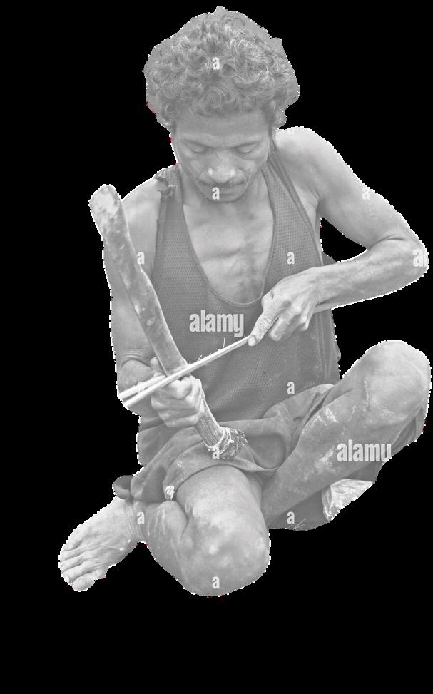
for land in the New Clark City project
struggleTribal Displacement due to the project


At this point in time, the Aeta people have not received the recognition of landownership and are continuing to be displaced by the NCC project.

decisionIt should be in our goals to build and create an inclusive 15-minute city. We are planning to co-exist the present and the past inhabitants from the area featuring their rich culture, way of life and crafts. This will be featured architecturally and will form a solution to provide them source of income too.

Ayta Na Market - Clark, Pampanga
Especially made for Aeta Vendors

design propone
Ancheta Jaeson


TUGBONG Marvin IGAGAMAO Arci MOSTRALES Ric


