2 minute read
The urban boundary The Cross of Blanquefort
STUDIO(ENSAP Bordeaux):La limite de Blanquefort
INSTRUCTOR: Prof.Laurent GOUYOU BEAUCHAMPS l.gouyou-beauchamps@bordeaux.archi.fr
Advertisement
2022.3-2022.6

*The preliminary stage of this project was to team up together for site research and modeling of the entire Blanquefort. However, the design part was done independently.
Thisproject was completed during my exchange study in France. The site is located in the small town of Blanquefort and the topic of discussion is urban boundaries. I carried out several field studies and analyzed the site thoroughly using various approaches.
I hope to mitigate the impact of flooding by enhancing the barge of the Jalle River. As well as sharing the drainage function of the city through ecological corridors, and making the ecological structure of the whole area healthier.
The project is located in Blanquefort, a small town north of Bordeaux,south France.
Blanquefort is surrounded by nature: green fields, vineyard, pasturs and forest .
A small river named jalle runs through the pasture, causing flooding during the annual rainy season, which affects the use of the pasture and also affects the city
Moreover, Blanquefort is also a town with stories: It has a medieval fortress, a war monument, and some parks. Green space.
Artificial construction land and buildings. Water.
1.PRE-ANALYSIS&PROBLEMS
IDENTIFY PROBLEMS : By investigating the flooding of the Garonne River, I found that Blanquefort was more severely affected by the flooding of its branch, the Jalle River.
PROBLEM ANALYSIS: To better analyze the drainage of the city, I used GIS and Grasshopper to analyze the terrain of the site.

Carte de l'état-major 1820-1866
Satellite imagery 1950-1965
Satellite imagery 1985 the
Ecologically incoherent:Urbanization of Blanquefort began in the 1960s. A town grew rapidly because of the establishment of a motor vehicle factory.The sprawling cities cut off the natural land.
Slope analysis and elevation analysis: the terrain of the town is significantly higher than that of the pasture.
Inundated area (rainy season) now
Inundated area (during flood) now Inundated area (during flood) 2050
Flooded area: With global warming. The problem of flooding in the site will become more and more significant, which will affect the architectural heritage as well as the farm.
2.CONCEPT
Concavity Analysis and Streamflow Analysis: Rainwater in the city collects in several "valleys" and eventually flows to the pasture.
1.Use ecological corridors to link the natural land in the north and south of the city
2.Create a buffer zone .
3. Establish a viewing platform adapted to floods.
4.The ecological corridor is below the urban ground level to facilitate drainage.
5.The line connects the different types of activities
Blanquefort Cemetery
3.Sustainable Landscape Design
Medieval fortress of Blanquefort
A slow walking path in the ecological corridor connects important landmarks of the town, such as monuments,
Pillwort
Plants that are more suitable for small animals to inhabit are added to the
Blanquefort Cemetery
Milium
War monuments
Wild flowers are planted along the waterfront because they require less
Wetlands that share the impact of flooding. Preserved original forest.
Angelica heterocarpa Acer
Family Farm (Expansion)
Fagus sylvatica
Entrance to the fortress
Garden platform
Linear pastures (avoid flooding)
Euphorbia palustris
Ecological patches that were once broken
Family farm manual model
Medieval fortress of Blanquefort
Widening of the Jalle River Valley flood discharge wetland
Jonc fleuri
By adjusting the boundary form, the ecological patches are connected
Gentiana pneumonanthe
The scale of the ecological corridor is suitable for the migration and residence of small mammals, birds and insects, while livestock such as cattle live in the enclosure of the pasture
The direction of flood discharge is defined by sinking wetlands. The pastures can retain the original area and be distributed linearly on the right bank of the river where flood disasters can be avoided
*Source: Guide_Parc_des_Jalles editor: Alain Anziani Bordeaux Metropole drawing:Ziyun ZHOU

4.Landscape perspective view
6.Hand-made model
5.Ecological design

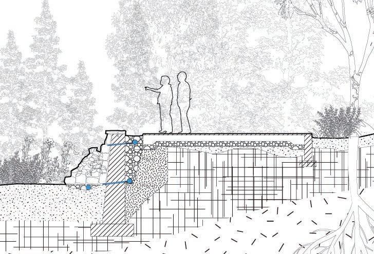
7.Landscape Detail Design

1.COMPACTED SUBGRADE
2.PERFORATED DRAIN PIPE
3.30 - 40 MM AGGREGATE
4.50 MM WEEP HOLE
5.NATURAL ROCK BOULDERS
6.GRAVEL BASE COURSE
NATURAL ROCK can give more convenient for small animals to climb or perch .In addition, the design of urban drainage has been taken into account too.


