2 minute read
Climate driver changes gears
by AgriHQ
By Phil Duncan
The team at WeatherWatch takes a look at the weather patterns to see what farmers may have in store for autumn.
As La Niña conditions continue to clear away, many are asking whether that means El Niño is next. We talked about this in the December edition of Dairy Farmer, but between La Niña and El Niño we need to go to neutral. If La Niña is first gear, El Niño is reverse.

The neutral phase can be a very positive one for farmers and growers –though maybe not for all – but generally speaking this neutral phase offers one key word: “variety”.
Neutral patterns have no big climate driver – we don’t have La Niña creating more rain to the north, we don’t have El Niño parking more high pressure zones in the Tasman Sea. Instead, New Zealand has what can be described as a “typical” weather pattern set-up.
Variety also means chaos. We can have a tropical low one week, a southerly blast the next week, then maybe two weeks of calming high pressure in between.
As we left February and slipped over to March the weather pattern changed with it. Easterlies, which had been dominating many parts of NZ for the past couple of months, have now switched to the typical windy westerlies of autumn. This weather pattern has already set in across southeastern Australia, with Victoria and Tasmania particularly exposed to gales and colder, wetter changes in the past couple of weeks.
In true autumn style places like Melbourne are swinging from highs in the teens to highs in the 30s from week to week.

The South Island of NZ is similar to Victoria, also getting hot nor’westers one day and colder southerlies the next. Likewise, Christchurch is also having daytime highs in the teens some days, other days in the mid to late 20s.
Normally in autumn the eastern North Island doesn’t want a surge of dry, windy westerlies. This year it is just what the doctor ordered. This set-up is ideal for helping the saturated eastern North Island (Hawke’s Bay in particular) start to dry out and return to normal. Rivers remain muddy (or murky), so the longer dry spells will also help clear up waterways further. It will also help solidify slips that may still be unstable.
But neutral patterns also mean we need to keep an eye on the tropics. March is the peak of the cyclone season and so even as La Niña goes the risk for tropical storms is still there. The tropical cyclone risk carries on through April, too. Our long-range IBM data at RuralWeather.co.nz suggests an increased risk of rain still for the upper and eastern North Island in April – this may be due mostly to the risk of tropical lows. So while the risk is heightened for more rain, there is still a good chance any tropical lows/storms that form will entirely miss NZ.
Sometimes it feels like NZ is a few bowling pins and a tropical cyclone is the bowling ball – the cyclones often go into the “gutter” east of NZ and get pulled away to the southeast due to the Coriolis effect (Earth’s spin and the effect that has on the tracking of air pressure systems).
In a nutshell, the neutral weather setup brings variety and chaos – and less of an obvious pattern. Autumn’s westerlies tend to always pick up around now though.
This is caused by high-pressure systems tracking further north and this placement creates westerlies.
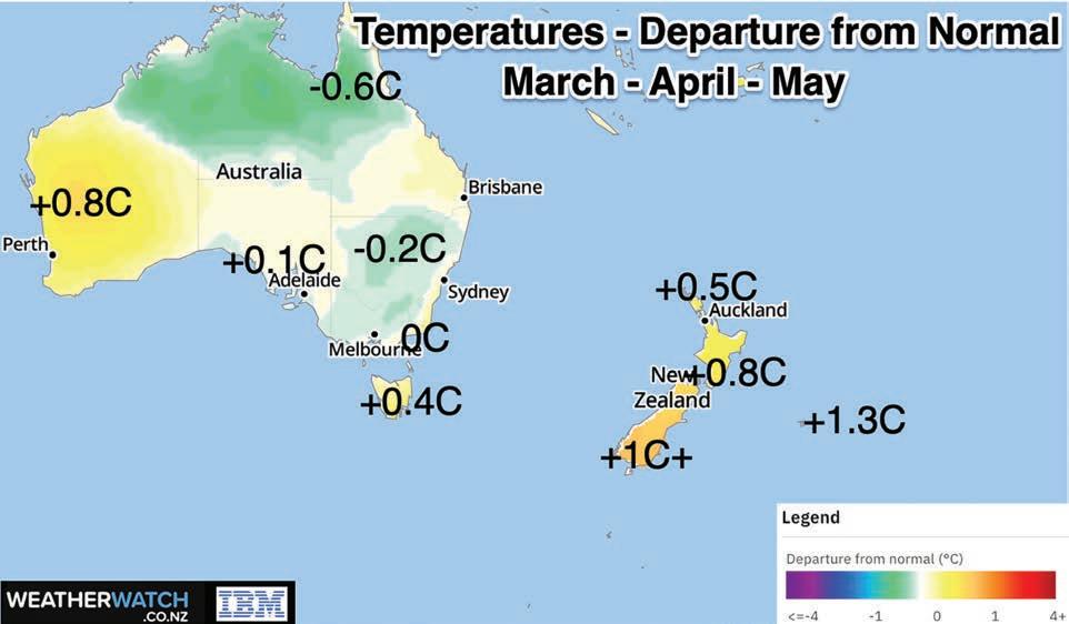
It’s also likely to be warmer in NZ over the next three months compared to what has historically been recorded. This continues a trend we’ve had in NZ for the past several years now. As you can see from the map, it’s not the case across Australia due to more rain/cloud in some areas.


