6 minute read
The Garden Route in flames: Working towards a detailed five-year fire prevention plan - Chapter IX

The Garden Route in flames: Working towards a detailed five-year fire prevention plan
Chapter IX
A book by Dr Neels de Ronde
The following article is the ninth chapter in the series of excerpts from a book written by Dr Neels de Ronde, The Garden Route in flames. This is the last in the series of articles. We have also made these articles available on our web site, www. frimedia.org or www.fireandrescue. co for ease of reference.
Dr De Ronde lived in the Southern Cape in South Africa and had done extensive research in the field of land management and wildfire prevention. Dr De Ronde gave permission to Fire and Rescue International to publish his book in the magazine in separate sections for the benefit of all forestry and wildfire managers, fire protection associations and land owners in order to gain insight and an understanding of the intricacies that form the basis of such extreme fires and how it can be prevented, highlighting effective fuel management and fire prevention measures.
Working towards a detailed five-year fire prevention plan
It is only once the regional fire prevention plan has been drawn up as set out in Chapter III and considering all aspects required for further development work on fire prevention (as set out in Chapters IV to VIII) that a detailed five-year fire prevention working plan can be drawn out for pre-determined sub-regions.
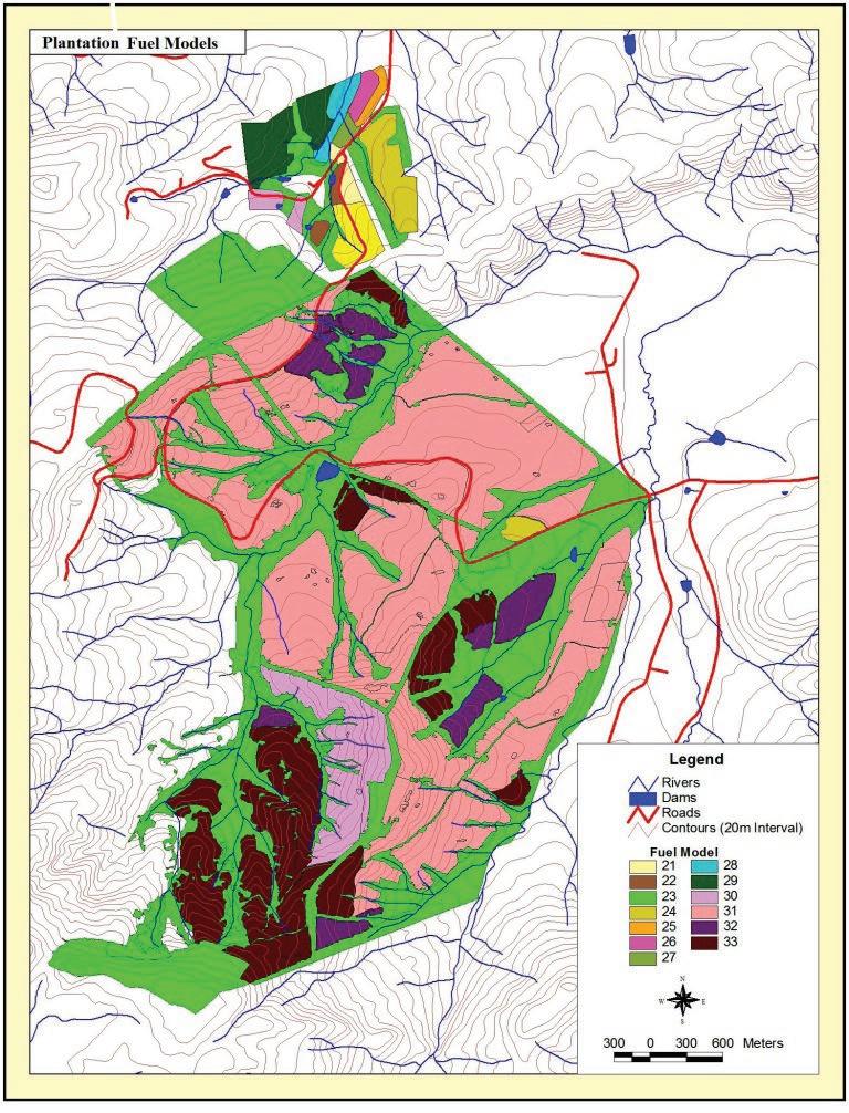
Firstly, each sub-region’s fire hazard status has to be classified, calculated and mapped, using pre-determined procedures as set out in Chapter V. These fire hazard rating classifications when mapped, will form the basis for the detailed five-year plan to be developed for each sub-region and the results will then be mapped on fire prevention maps by sub-region (Calvin et al., 2004).

Map 3 (above) provides an example of what a sub-regional fire hazard rating (FHR) map for a Garden Route sub-region can look like for a five-year period (say 2021 to 2025). This can then be used as a basis for the development of IFP units used, from regional (main) buffer zones (B) through internal buffer zones (IB), to public road protection (PR) and conservation burning (CB).
An example was provided below of a sub-regional IFP unit with dominant Industrial Pine Plantation Forestry as land use, within a montane/wetland Grassland natural vegetation base. An example of such a sub-regional IFP plan is provided below (Map 4). Detail of such a year-plan-section has been provided below to illustrate how such a plan can be developed for practical use:

Example of section of a subregional IFP plan (Not related to Maps 3 or 4)
External buffer zones
B6: Yearly controlled burning of the external firebreak, as well as all available grassland on both sides of the common property boundary. Also under canopy burning as indicated on the mal as follows: Compartments M16 (pt) approximately 8.0ha, M11D 2.1ha, M11C 1.0ha, M11B (pt) 20.7ha, M11A 6.3ha, N06 2.4ha and N05A (pt) 8.0ha Total = 48.5ha. Compartment. M12 (pt) to be incorporated in B6 external buffer zone after 2021/22.
Internal buffer zones
All riparian zones (within the IBs as set out below (IB4 – IB7) should be prescribed-burned according to the original FP plan but in two ways:
Narrow wetlands PB on twoyearly rotation as a whole. If similar narrow wetland closeby, burn these two wetlands alternatively yearly in tandem.
Wider wetlands PB of approximately 50 percent of wetland on one side of watershed and remaining 50 percent of wetland on alternative side of the watershed.
Compartments with the IBs should be prescribed burned as follows:
IB8: Riparian zone areas should be controlled burned according to the above procedures.
Protection along public roads
PR7: Yearly burning of all burnable material within road shoulders to be prescribed burned. Burn approximately 50m east of road shoulder as indicated on the map. North of road reserve, in Compartments M18, M19, M25A and Q18 under canopy burning should be applied in strips as indicated on the IFP map. Compartments M16, M17A, M23, M24B, Q19, SM02, SM05, MB08A and MB01 to be incorporated into this PR after 2021/22.
PR8: Yearly burning of all burnable material within road shoulders to be prescribed burned. Burn approximately 50m along road shoulders as indicated on the map. South, east and north of the road reserve (as indicted on the map) the following Compartment strips should also be added and prescribed burned: Compartments G17, G18A, G18B, F01, G06 and G07B.
PR9: Yearly burning of all burnable material within road shoulders to be prescribed burned. Burn approximately 50m along road shoulders as indicated on the map. North of the road reserve (as indicated on the map) the following compartments should be added and prescribed burned: H12B and H07. Compartments H11A, H06B, H06A and H01 should be added to PR9 after 2021/22.
PR10: All burnable material within road shoulders to be prescribed burned. Burn approximately 50m along road shoulders as indicated on the map. As indicated on the map the strip of this PR should be added to the following compartments: X16B, U05A, U07, U15, T08, T06, T7A, T07B, T03, T19 and T18A (estimated total area can be added to this years’ programme). Compartment U07 only after 2021/22.
PR11: Yearly burning of all burnable material within road shoulders to be prescribed burned. Burn approximately 50m along road shoulders as indicated on the map. North of the road reserve (as indicated on the map) the following compartments should be added and prescribed burned E and N as indicated on the map): S05A*, S09*, S08*, S07*, P30B, P28A*, P20*, P19*, P13, P12, P9A, P08, P05, P04, V16, M23*, M26, Q04A, Q05D, Q05B, Q05A, N01B, N02* and N01A.
*=Only after 2021/22.
Conservation burning
CB2A - D: Prescribed burning of all available grassland yearly, with exception of wetlands which should be prescribed burned as explained below on a two-year rotation.
All wetlands according to original FP plan but in two ways:
Narrow wetlands PB on two yearly rotation as a whole. If similar narrow wetland closeby, burn these two wetlands alternatively yearly in tandem.
Wider wetlands PB of approximately 50 percent of wetland on one side of watershed and remaining 50 percent of wetland on alternative side of the watershed.
PL2: To be burned yearly as prescribed.
Summary of total areas to be under tree crown canopies during 2017/18
(Priorities of burning provided in brackets)
B(I) IB(II) PR(I) CB(I) Total
48.5ha 0.00ha 0.00* 0.00ha 48.5ha
*=Still to be estimated after burning.