15 minute read
Understanding structure


Understanding structure and cover to find fish
BRISBANE Sean Thompson
So much is written about the best times, tides, tackle, baits, lures and more to find fish consistently. All of these factors are important. But probably the number one reason for a fish to be in an area is the presence of a combination of structure and cover.
In the absence of any underwater structure, fish may travel through an area but will generally keep moving in the search of food or cover or both.
While many anglers may be familiar with the terms structure and cover, it is fair to say that they are often incorrectly used interchangeably. Furthermore, it is one thing for an angler to recognise the terms, but another to also understand why and when fish utilise these features. This ability is probably one of THE key ingredients in the make-up of the most successful anglers.
STRUCTURE AND COVER
So, what is meant by the terms structure and cover?
In fishing terms, structure can best be described as the physical features of the bottom and outer limits (shoreline) of a body of water.
This structure may have been formed naturally, e.g. currents scouring out a drain over soft sand on the estuary Flathead are perfect targets in estuary structure, such as muddy sand flats interspersed with weed.
flats, or artificial e.g. a dredge digging out a deeper entrance to a river entrance after it has become silted up. Structure provides a couple of key uses for fish. This includes attracting baitfish (e.g. to hold position in a beach gutter close to shore); as a place to hold position out of the main current; or as an ambush point to attack their prey. Fish also use structure like an underwater roadmap to move around in, e.g.

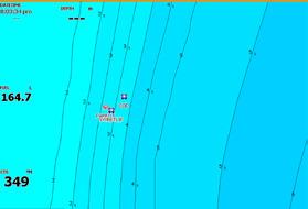
My sounder’s contour map showing a steep shelving bottom on the left (close contour lines) and two deep holes (close circles). to move along in a long beach channel.
Cover on the other hand is anything that fish can use including beaches, estuaries, freshwater, bays and offshore. THE BEACH
The beach holds so many options and so much potential if you know how to make the most of it. Constant waves, swell, changing tides and wind results in constantly shifting weeks of strong onshore or sea breezes, heavier waves and swells develop, causing new deeper formations close to the shore as the swell pounds out and removes sand close to shore.
On the other hand, calmer land breezes (or offshore winds) have the effect of flattening the swell sands back towards the shore filling in the structure of those churned out sand formations.
For beach anglers, the main formations caused by these shifting sands under the water are gutters, holes, channels and spits. These beach formations are best spotted from an elevated

Steeply shelving shore-based structure that drops into darker green water is a great spot to target fish like tailor, salmon (down south) and even mulloway.
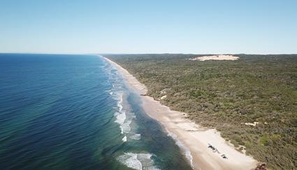
Structure, such as this long beach gutter on Fraser Island, with two exit points (rips) to deeper water is a perfect location to target fish like tailor. level, either from viewing platforms or dunes above the beach. Basically, you are looking for changes in structure (in this case, the sand bottom) which is obvious by the colour of the water and wave behaviour.
Darker water means deeper water scoured out of the sand. Steeply shelving sand into darker water is also a sure sign of deeper water close to the beach. Waves which break offshore before reforming and don’t break until they get closer to shore is a giveaway of the type of bottom structure. Firstly, the waves are breaking over a back shallower sandbank and then reforming and not
to take refuge or hide under or around e.g. underwater snags. Cover can also be used by predators such as flathead, mangrove jack and barramundi to hide in or under to ambush their prey.
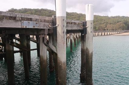
Cover can be either natural features like seagrass, fallen timber, lily pads or rocks or man-made such as dam walls, bridge pylons, wharves and jetties, pontoons and marinas and breakwalls. Artificial cover often provides a dual benefit to the fish, i.e. a place to conserve energy and sit out of the current while also using it as a position to feed on the titbits swept past in the current. TYPES OF STUCTURE AND COVER
With that distinction out of the way, let’s now consider some of these features in various waterways Cover in the form of a boat ramp pontoon. Note the rippled water on the windward side, which would be where fish are holding.

I go into much more detail on beach formations in my article, “Mastering the art of fishing the beach” in the July 2019 edition of what was Queensland Fishing Monthly, and is available online. But for the sakes of this article, very long stretches of deep water running parallel to the beach are channels, or natural highways for the fish to travel along in search of food or more isolated structure, which will hold bait. Better spots to target on the beach are smaller formations of deeper water either in the form of a gutter with an entry and exit point to deeper water or isolated deep holes close to shore. Smaller species like whiting prefer calmer shallow gutters close to shore at low tide, while bigger species like tailor, salmon and mulloway prefer to hunt the deeper water of gutters, but Hooked up on a freshwater bass after using the sounder to find bait near the old riverbed.

if you really want to learn to find new or less fished ground yourself you need to learn to read and interpret a sounder fitted with good quality nautical charts/
These can be found by the use of either two-dimensional contour maps that use colours and shades to show different depths. You should examine

Shallow drains either side of a sand spit is great structure to target whiting on a rising tide on the estuary flats.
don’t dismiss the offshore sandbank of such gutters covered at high tide even during the middle of the day.
Finally, be aware also that isolated patches of cover such as rocky outcrops along the beach will also attract fish around them. Further, don’t dismiss natural cover such as floating dune seagrasses after heavy seas or even flotsam such as wood or material from a shipwreck as a potential fish attracting item in inshore gutters.
BAY AND OFFSHORE
Bay and offshore fishos are faced with huge expanses of water in which to fish from. This can be both exciting but on also overwhelming to new anglers or unsuccessful anglers wondering where to fish next.
This is where the importance of finding structure and cover is critical. A bit of research online, or a chat at the closest tackle shop to the ramp might help steer you in the right direction. But steep slope or drop off), or a circular shape with increasingly smaller circles inside it to indicate an ocean trench or underwater rise.
Raised-relief maps or terrain maps offer a further advantage as they show a 3-dimensional shaded view of the bottom structure using high resolution sonar.
In general, offshore and bay anglers should be looking for areas where the flat bottom surface is punctuated with natural or green or grey water can be the result of northerly surface winds pushing warmer surface waters out to sea and replacing them with colder, murkier (more sediment rich) water which has come from deep water upwellings.
These changes can of course also be picked up by your sounder, noting however it is reading surface temperatures only. Not all fish like the warmer blue waters however, and many on the last couple of hours of the rising tide can also be ok, but you need to be prepared to float your baits or throw your lures under the cover where the fish will be sheltering. This requires slightly heavier tackle and tighter drags! The use of burley can also be useful to bring the fish to you. Note too the direction of the wind when fishing such locations and fish the windward rather than the calm leeward side. This is

Shallow beach gutters are perfect structure to target whiting feeding right on the shore.
maps. Such charts will help you discover structural changes to the bottom including ledges, drop offs, pinnacles and holes along with cover such as weed beds and rocks. these maps for variations in the contours, which is a sign of changes to the bottom structure. Look at where the contour lines get closer together or touch (indicating an underwater man-made reef, isolated pinnacles, trenches, weed beds or isolated rocks. These will attract bait and with them bigger fish.
Offshore anglers are also often on the lookout for more intangible changes in “structure” in the threedimensional layers of the ocean such as changes in water temperature and its associated colour. Water colour and temperature changes can be picked up by a combination of natural observation and your sounder. For example, marlin anglers chase warmer blue waters as opposed to dark green or grey murky waters, which are colder. Colder, darker bay and inshore reef anglers look forward to the arrival of colder more-nutrient rich waters to attract fish such as snapper. ESTAURIES, RIVERS,
CREEKS AND LAKES
Estuaries – including creeks, rivers, sandflats and lakes, truly contain a plethora of options for anglers either from the shore or a small boat. By understanding the underwater structure and cover throughout these environments will help you land more fish.
Let’s start with some of the man-made cover in our estuaries. These include physical infrastructure in and on top of the water that provides cover for fish such as bridges, jetties, marinas, pontoons.
Such locations offer great fish attracting potential as marine growth on their pillars and posts attracts baitfish which in turn attracts bigger predators. These locations also provide a break in the current or flow which provides a place for fish to conserve energy out of the current while at the same time, feed on food floating past with the current. Above water cover from these facilities also provides shade and protection from predators.
The peak time to fish these locations are change of light periods of dawn and dusk and as a general rule with a rising tide covering more of the marine growth on the posts and pylons. Daytime fishing, particularly due to the fact ripples on the water on the windward side provide protection, while it is also the area where food carried with the wind will be pushed to.
Many of these features also have permanent light sources that shine on the water. This attracts bait fish and squid and as a result big predators will lurk around the demarcation line of this light to attack prey that strays too far from the underwater protection of the poles, posts and other man-made snags.
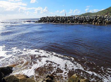
Another area of structure/cover to target is rockwalls. These provide access to deeper water and also act as a handy location to target fish entering and exiting the estuary with the tides. The underwater boulders provide a perfect environment for the growth of oysters and other marine growth. Likewise, the demarcation line between the sand and the rocks can also be a popular spot for bigger fish as a break in the current as well as an area to either eat the marine growth or target the baitfish it attracts.
A good way to fish rockwalls when they are not busy is walking the wall with floats and baits or just baits like ganged pilchards just weighted enough to hold bottom but move with the tide. If it is too busy to do so, you can use lures to either target an area of the rocks – a great option after floods have pushed big predators

out the entrance. Some other options are anchoring baits out the front of the wall or drifting lightly weighted or unweighted baits along the wall around the slower change of tide period.
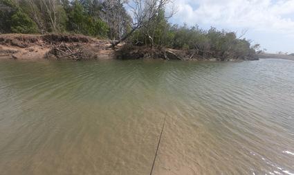
Estuaries are also filled with lots of underwater features that have multiple target areas. These include mangrove lined shoreline where it meets smaller drains or creeks, deep holes around the bends of creeks or other isolated features such as rocky outcrops near the shoreline or isolated patches of fallen trees.
Lightly weighted soft plastics jigged from under the cover of the Kingfisher Jetty at Fraser Island.
structure and cover in the form of underwater snags and overhanging banks and trees that provide cover for the fish.
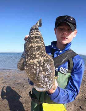
Some of my favourite natural structure target areas in estuaries include drains and melon holes along estuary flats, the edge of weed beds, isolated pockets of sand amongst the weed, sand and muddy drop offs from shallow flats into deeper water and the entrance of small creeks and inlets. Most of these spots are ideal target areas for flathead in the last two hours of the falling tide as baitfish flees from the shallows into deeper water.
Small melon holes, yabby beds and shallow drains on the estuary flats and mouths of creeks are also a top place to target whiting on the rising tides.
On a high tide, cover along the edges of the estuary including the edge of mangrove roots and tree snags are a top spot for a variety of species from flathead, to bream to mangrove jack and barramundi in the north.
One consideration though is that in some mangrove-lined estuaries there can be almost too many snags to cover! You have a couple of options here and that is to troll along the edge of such features to find fish, particularly in the hour or two as the tide starts to drop, or you find Rock walls provide food, shelter and access to fish entering and exiting the estuary. known to stalk their prey along shorelines and in running streams using polarised sunglasses and looking for subtle variations in the bottom or flow rates that will attract fish.
Likewise changes observed on the top of the water are another great way to track down freshwater fish. This includes fishing along wind lanes which carry floating insects as well as the fishing the windward sides of banks and islands (where the wind is blowing baitfish and insects towards).
So, there you go. Understanding structure and cover will help you find more fish no matter the waterway you are fishing. I hope that helps you to get a few more yourself. In the meantime, be sure to jump onto my social media
such as drowned timber and weed beds.
When I used to regularly fish the mountain lakes of Eucumbene and Jindabyne, I use to use my sounder and nautical charts to troll along shore based drop offs and contour lines. I use to also target deeper rocky ledges of the islands and steep rocky shorelines up some of the inflowing rivers.
A bit of research online or exploration of your charts will hold fish such as trout, bass or barramundi in the area. These include flooded fence-lines, drowned shorebased timber and also grassy banks which have become submerged due to rising water levels caused either by snowmelt down south or rains. These grassy banks are full of drowned worms, crayfish and grubs. Likewise drowned timber can not only hold grubs and insects, but also attracts
A perfect combo of a deep hole, shore based and underwater snags providing cover for both baitfish and ambush points for their predators. Small lures still catch big fish in shallow estuary flats.

small baitfish, shrimps or fingerlings to take cover which in turn attracts bigger predators to prey on them.
Trout anglers are also pages including Facebook, YouTube and Instagram under the name Ontour Fishing Australia for more tips and reports.
In estuaries where the snags are fewer and further between, then of course you should move from snag to snag and target them.
FRESHWATER
DAMS AND LAKES
Whether it’s the freshwater rivers, dams and lakes holding the likes of barramundi and saratoga in the north, or the trout lakes and streams of the south, freshwater waterways have similar structure and underwater cover that attracts and holds fish.
Once again, the use of a quality sounder will help you discover structural changes to the bottom including rocky shoreline ledges, holes, rises; as well as underwater cover for fish can help you pin point old riverbeds that impoundment bass and trout like to follow. In fact, switched on trout anglers use downriggers during summer to troll along these deepest (and coldest) parts of the lake. I also fished with a friend successfully for bass on Lake Somerset in QLD by using his sounder to find schools of bait along the old riverbed and in turn catching a bunch of fish using floats and live shrimps. Don’t just rely on technology though, as you can also find bait and fish by observing live gannets diving for baitfish.
Anglers can also observe a range of freshwater bottom features, which provide cover or current breaks and Jetties and wharfs provide perfect cover and food for fish.