ATHENS-CLARKE COUNTY PLANNIN G COMMISSION RECOMMENDATION
DATE: December 8, 2022
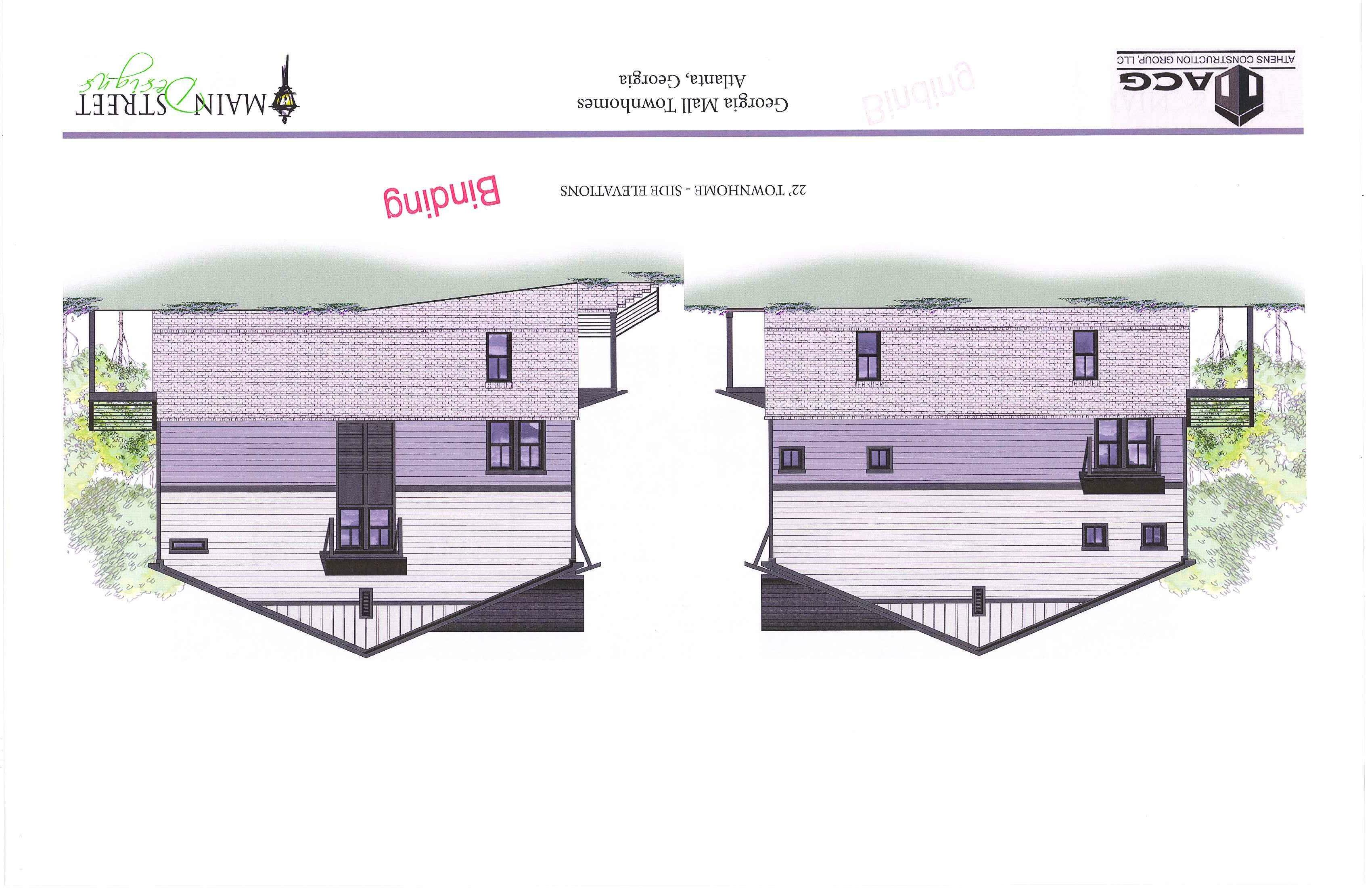
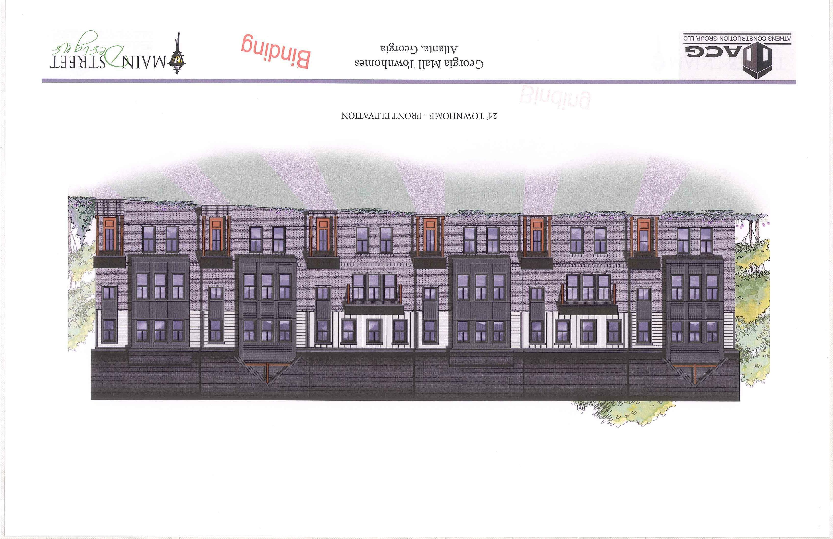
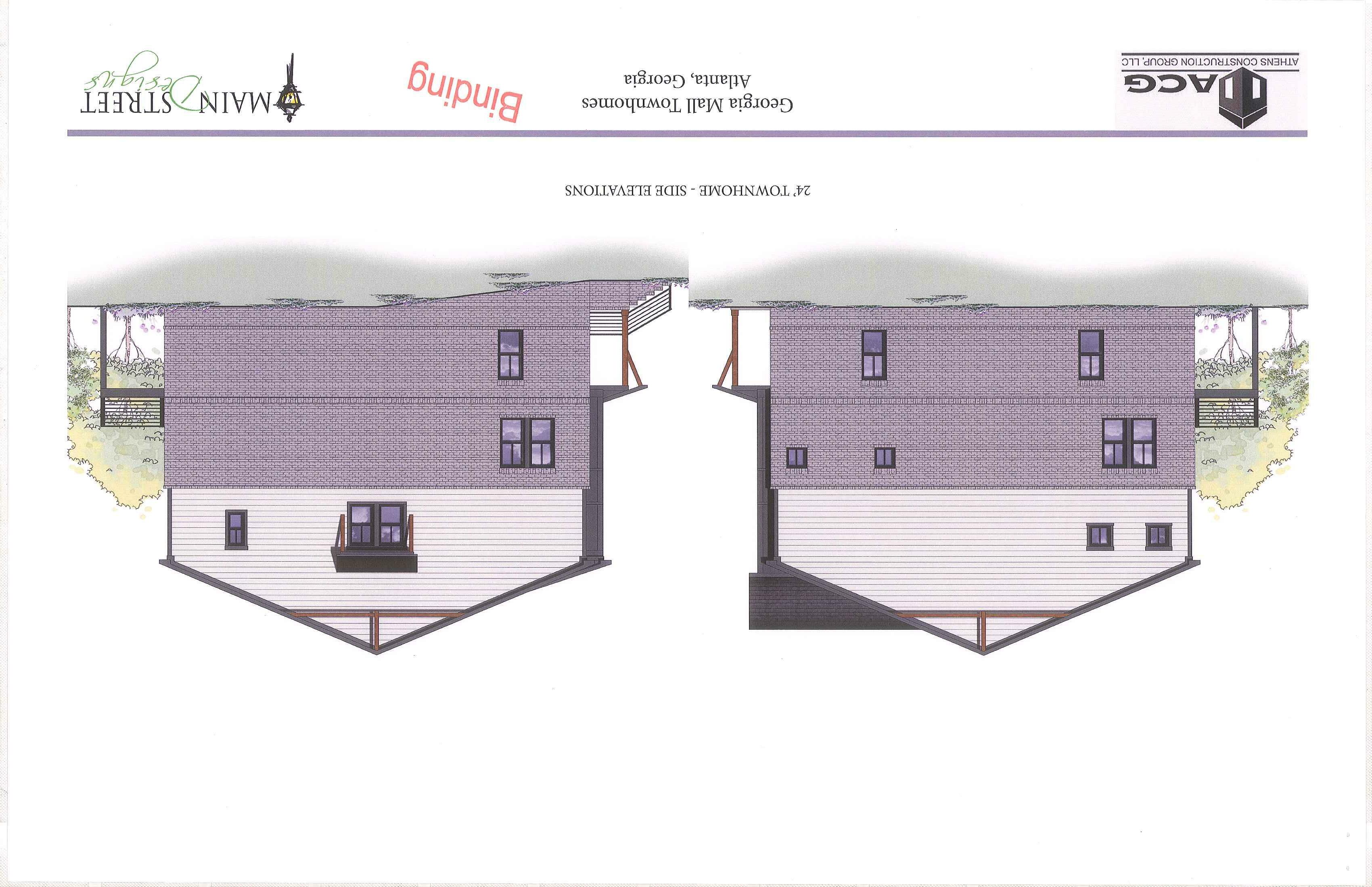
FILE NO: PD-2021-12-3752
LOCATION : 3700 , 3706, 3708, 3710 Atlanta Highway
APPLICANT: Scott Haines I W &A Enginee rin g
OWNER: Athens Construction Group Property Holdings, LLC I KDI Athens Mall , LLC I KDJ A n chor, LLC I KDI Athens Outparcels, LLC
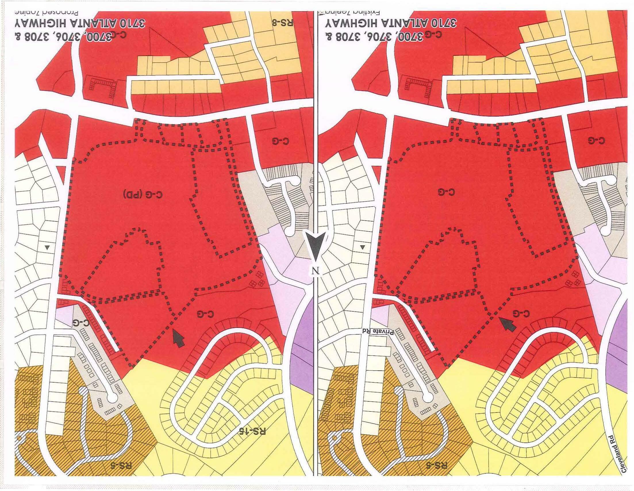
REQUEST: From Employment Ce nt er & General Business to Gener al Business COMMISSION DISTRICT : 6
PLANNING COMMISSION MOTION AND RECOMMENDATION:
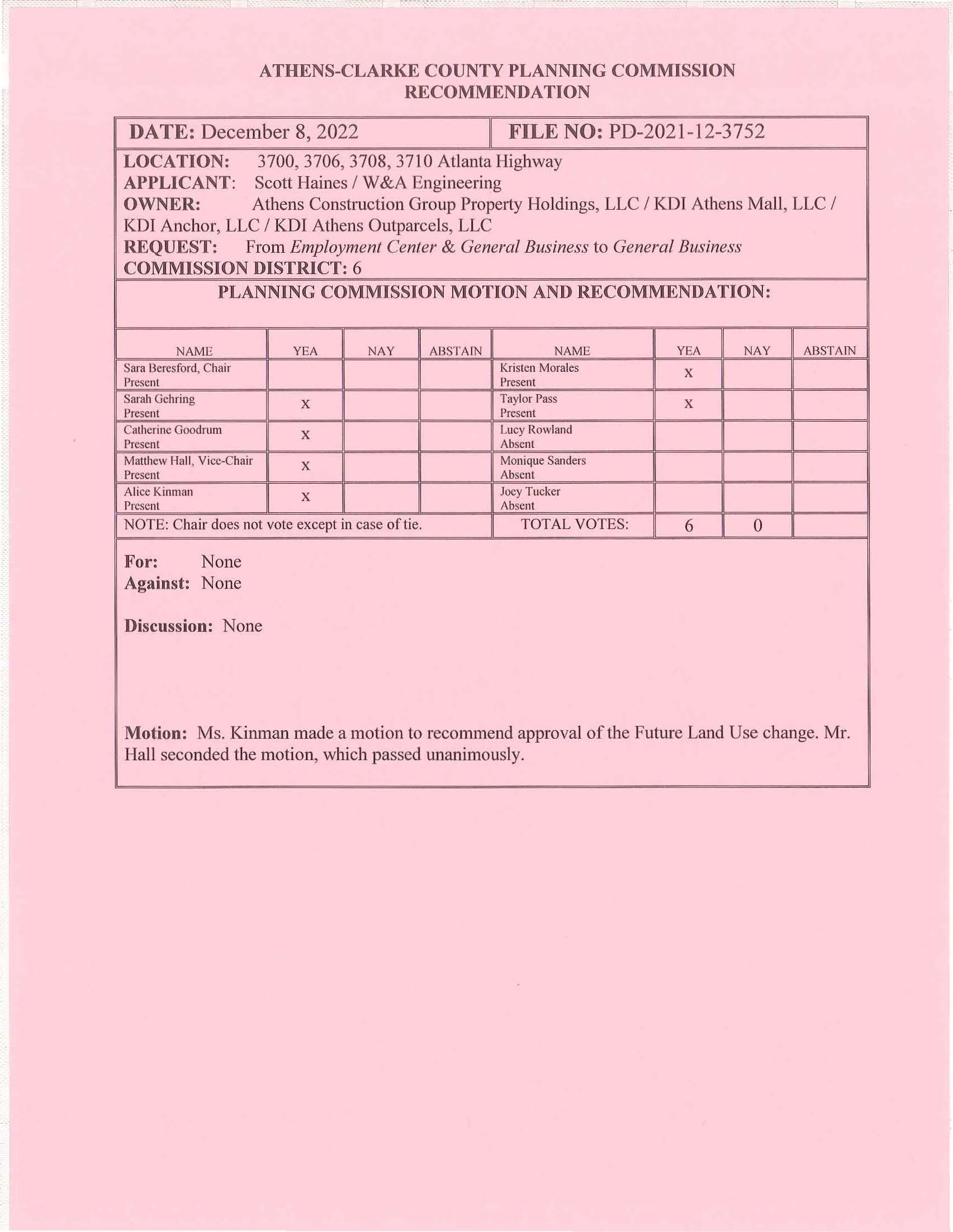
NAME YEA NAY AI3STAfN NAM E
YEA NAY ABSTAfN
Kristen Morales X Present Present Sarah Ge hrin g Present X Taylor Pass Present X
Sara Beresford, Chair
Catheri ne Goodrum X Lucy Rowland
Present Abse nt
Ma!!hew 1-fa ll , Vice-C hair X Mo nique Sande rs Presen t Abse nt
Ali ce Kinman X Joey Tuc ker Presen t Absent
NOTE: Chair does not vote except in case of tie.
For: None Against: None
Discussion: None
TOTAL VOTES: 6 0
Motion: Ms. Kinman made a motion to r ecommend approval of the Future Land Use change. Mr. Hall seconded the motion, which passe d unanimously.
ATHENS-CLARKE COUNTY PLANNING COMMISSION RECOMMENDATION
DATE: December 8, 2022
FILE NO: PD-2021-12-3752
LOCATION: 3700, 3706, 3708, 3710 Atlanta Highway
APPLICANT: Scott Haines I W&A Engineering
OWNER: Athens Construction Group Property Holdings , LLC I KDI Athens Mall, LLC I KDI Anchor, LLC I KDI Athens Outparcels, LLC
REQUEST: From C-G to C-G (PD) (Commercial-General to Commercial-Genera l, Planned Development)
COMMISSION DISTRICT: 6
PLANNING COMMISSION MOTION AND RECOMMENDATION:
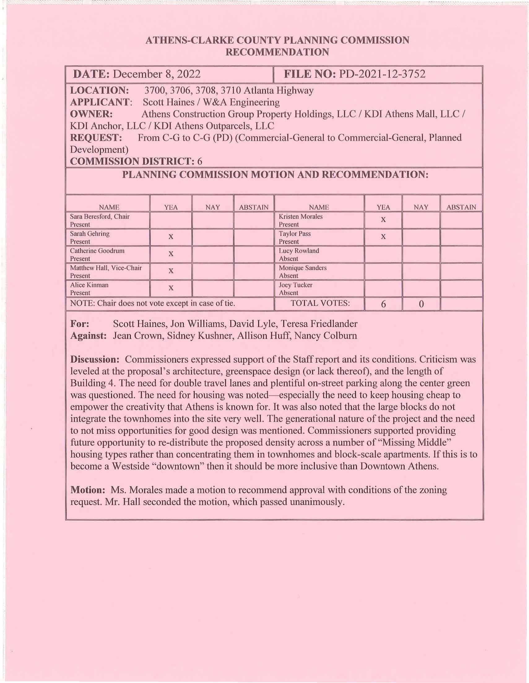
NAME YEA NAY ABSTAIN
NAME YEA NAY AB STAIN
Sara Beresford , C hair Kristen Morales X
Present Present Sarah Gehring X Tay lor Pass X Present Present Catherine Goodrum X Lucy Rowland
Present Absent Matthew Hall , Vice-Chai r X Monique Sanders
Present Absent Alice Kinman X Joey Tucker Present Absent
NOTE: Chair does not vote except in case of tie.
TOTAL VOTES: 6 0
For: Scott Haines, Jon Williams, David Lyle, Teresa Friedlander Against: Jean Crown, Sidney Kushner, Allison Huff, Nancy Colburn
Discussion: Commissioners expressed support of the Staff report and its conditions. Criticism was leveled at the proposal ' s architecture, greenspace design (or lack thereof), and the length of Building 4. The need for double travel lanes and plentiful on-street parking along the center green was questioned . The need for housing was noted- especially the need to keep housing cheap to empower the creativity that Athens is known for. It was also noted that the large blocks do not integrate the townhomes into the site very well. The generational nature of the project and the need to not miss opportunities for good design was mentioned. Commissioners supported providing future opportunity to re-distribute the proposed density across a number of "Missing Middle" housing types rather than concentrating them in townhomes and block-scale apartments. If this is to become a Westside "downtown" then it should be more inclusive than Downtown Athens.
Motion: Ms. Morales made a motion to recommend approval with conditions of the zoning request. Mr. Hall seconded the motion, which passed unanimously.
STAFF REPORT
MASTER PLANNED DEVELOPMENT CASE NUMBER PD-2021-12-3752 3700,3706,3708, & 3710 ATLANTA HIGHWAY DECEMBER 8, 2022
GENERAL INFORMATION AND PROPOSED DEVELOPMENT
l. THE REQUEST
APP LICANT Scott Haines I W &A Engineering OWNERS KDI Athens Mall , LLC. ; KDI Athens Anchor, LLC.; KDT Athens Outparcels, LLC .; Athens Construction Group Prope1ty Holdings, LLC
FUTURE LAND USE REQUEST. ............. .............. From Employment Center & General Business to General Business ZONING REQUEST ........ ................
From C-G to C-G (PD) TYPE OF REQUEST .................. ............................ .. Type I LOCATION 3700 ,3 706,3708,3710 Atlanta Highway COUNTY COMMISSION DISTRICT 6 SIZE OF REZONING AREA .. .... ...... .... ...... ...... . ...... 74.8 acres PRESENT USE Commercial PROPOSED USES ................................................... Residential, Commercial, and Office Mixed Use TAX MAP NUMBERS 073 016; 073 016F; 073 0161; 073 016K; 073 0 16S; 073 016T
ADJACENT USES AND ZONING ......................... (N) Offices I C-G; Residential Op e n Space Lot I C-G & RS-15
(S) Atlanta Hwy; Quick-Service Restaurant s, Vehicle Service I C-G
(E) Huntington Rd; Single-Family Residential I RS25; Bank ATM I C-G (W) Gas station, Brewpub I C-G; Multi-Family Residential / RM-1; Assisted L iving Facility I C-0* STAFF RECOMMENDATION Future Land Use -Approval Zoning- Approval with Conditions
PLANNING COMMISSION Future Land Use -Approval
Zoning- Approval with Conditions
II. PURPOSE
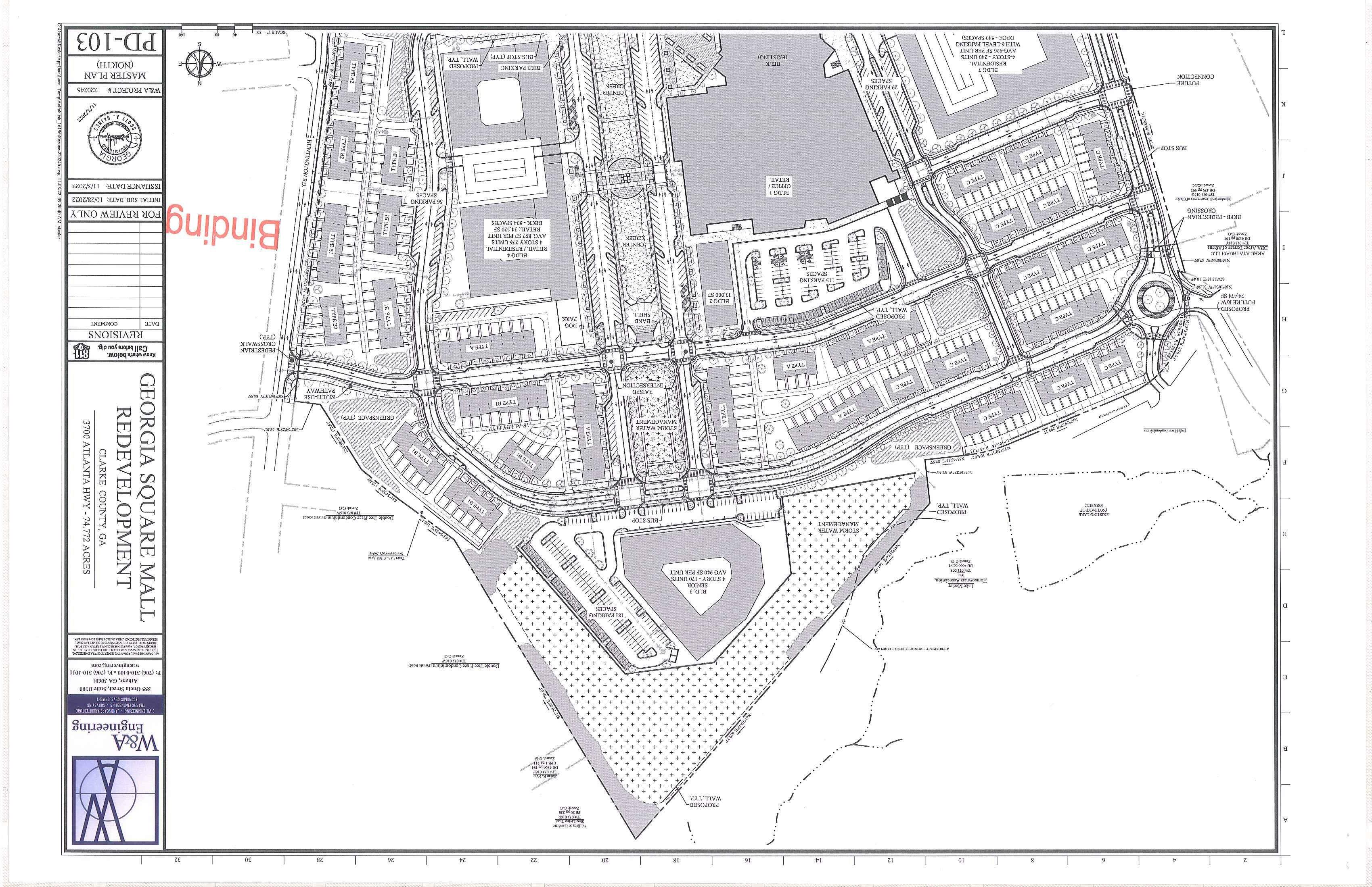
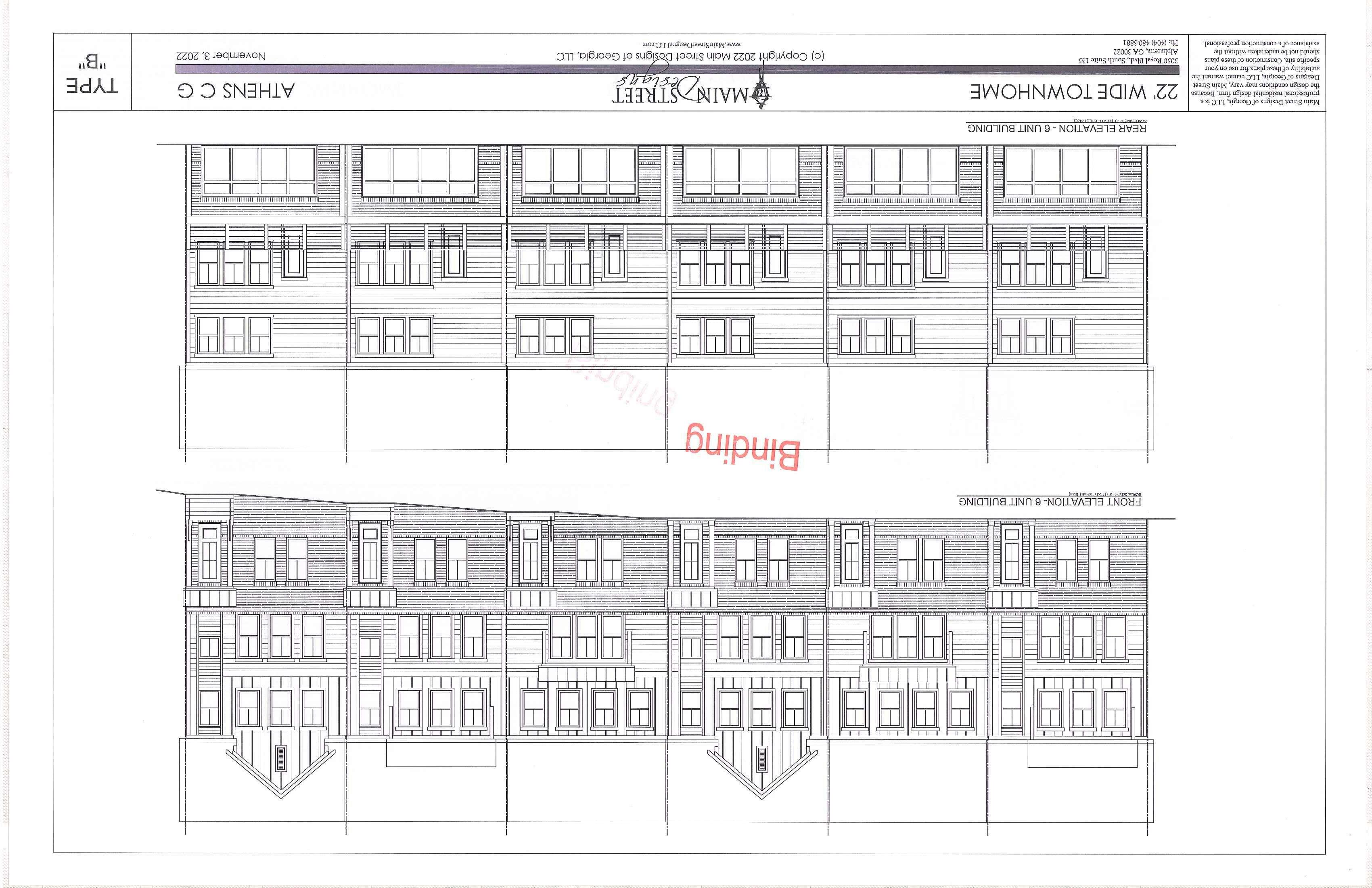
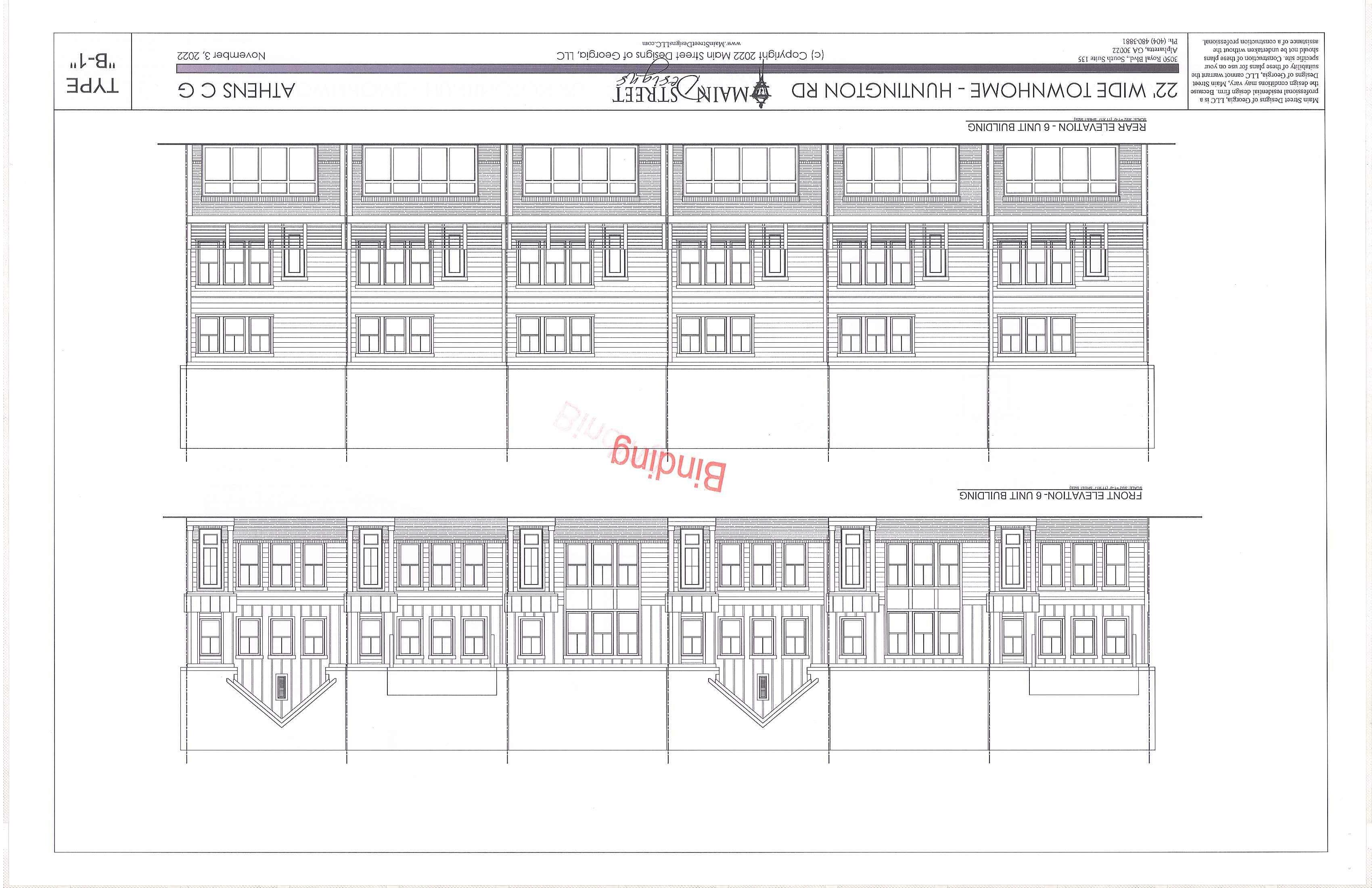
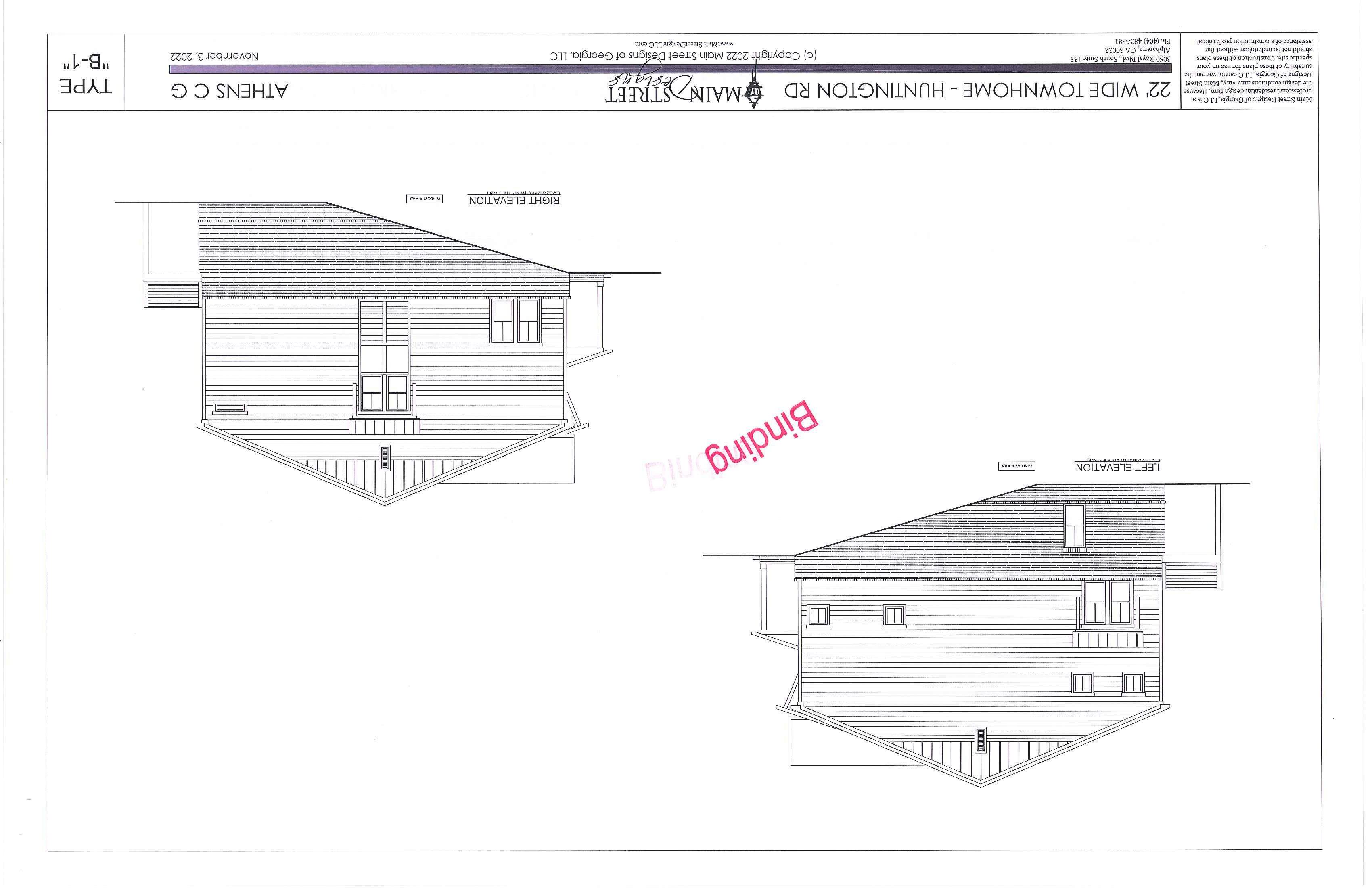
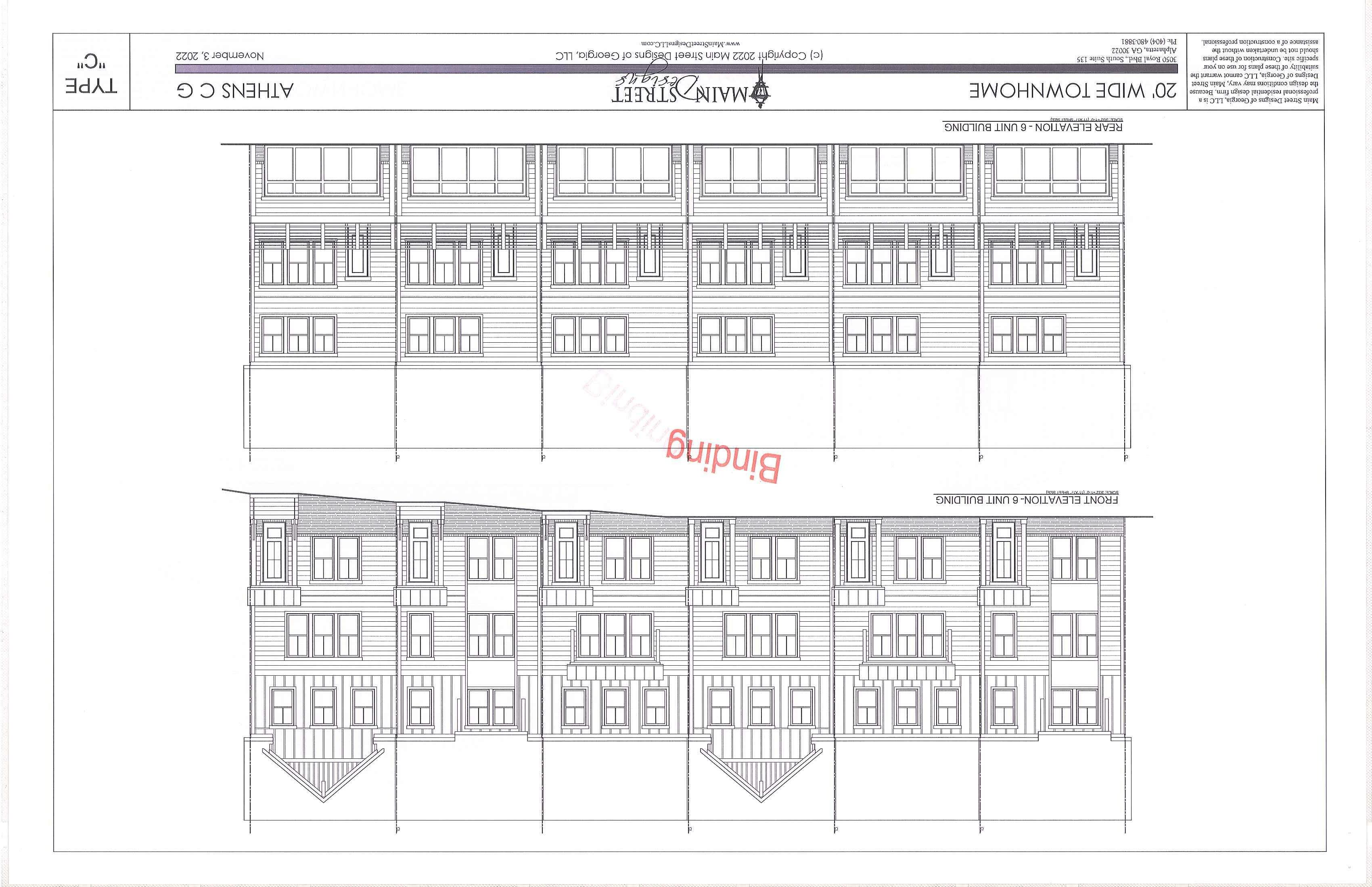
The purpose of this request is to rezone six (6) parcel s currentl y zoned C-G (Commerc i al General) to C-G (PD) (Commercial General, Planned Devel opment) i n order to construct a residential, commercial, and office mixed-use development on a 75-acre site. A p lanned development is being requested due to several requested waivers of required standards to provide design flexibility. A planned development includes a binding application report, site p lan, and architectural e levations as a guarantee to the community that what is proposed would be constructed. The request conforms to the current Future Land Use Map with the exception of the northernmost parcel of the subject property.

... ............ .........
....................... . .......................... .... .. ................. ... .....
.............. ;............................................... .....................
..
................................................... .............
...............
....
,..
ill. BACKGROUND OF SUBJECT PROPERTY AND VICINITY
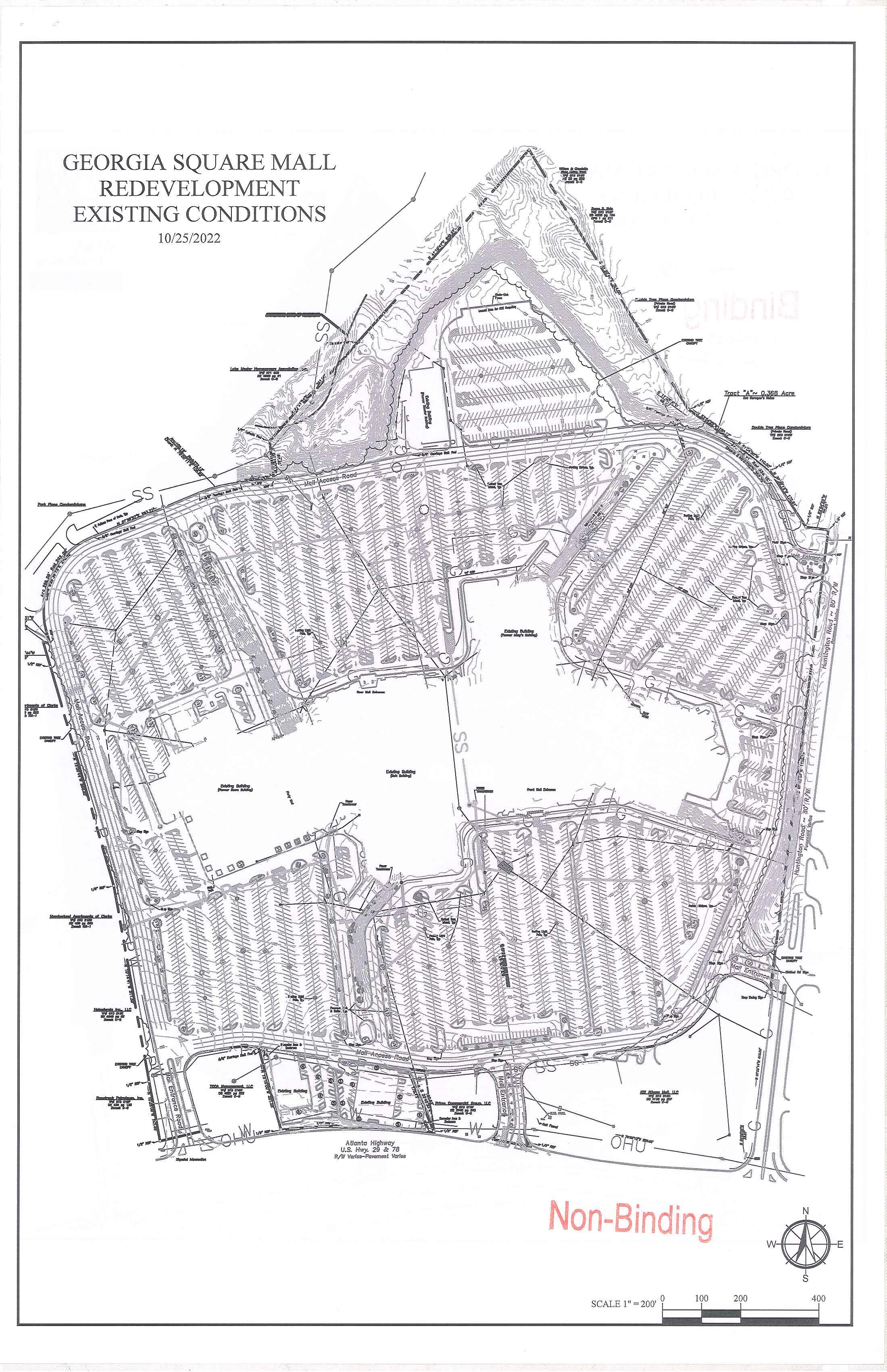
The s ubj ect parc e ls are the site of the Georgia Squ a re Mall, two associated outp arcels along Atlanta Highway, and the former movi e theatre to the rear of the m all. Georgia Square Mall was co nstructed in th e early 1980's, and h as ex is ted as the primary l a rge -scale mall in Athen s- Clark e Cou nty s inc e that time, with num er ous t enants occupying the structur e itse lf ove r the years. The 2-story buildin g is approx imate ly 800,000 square feet and formerly had four anchor tenants : Macy 's, Sears, J CPe nn y, and Belk. Macy 's cl osed in 20 17, Sears in 20 19, and JCPelllly in 202 0 Belk is cun·ently the only remaining anc hor st ore. In addi tion to the com mercial uses, there are public serv ices on s ite including an. A thens-C larke County Police sub s tati on within the Mall, a Solid Waste recycling site, and two Athens Transi t bus sto ps serv in g Routes 2 0 a nd 2 1 located on th e property.
The tw o outparcels along Atlanta Highway (3706 and 3708) were constructed around the sa me time as th e mall. Both parcels co nta in commercial buildings that are currentl y vacant. The no rth ernmost parcel at 37 10 At la nta Highway contains a structure, built in 198 4 , which formerly hou sed a movie theater. The remainder of the subject property consists of surface parking and a private Mall Access Road th at circles the property. The subject property fronts Atlanta Highway and Huntington Road and has five access points , includin g one off of Mar il yn Farmer Way at the property's no rthwes t comer.
The su bject property is located within a designated Tax Allocation Di strict (TAD). A TAD advisory committee h as been formed to oversee funds raised through the District for redevelopment purposes.
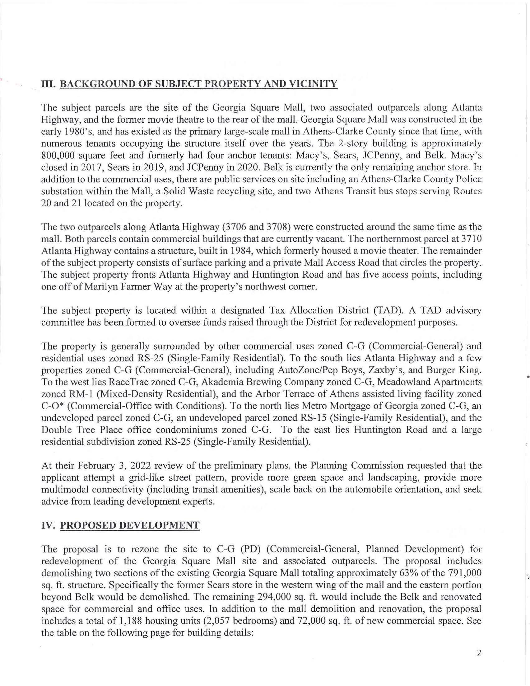
Th e propert y i s ge nerally surrounded by other commercial uses zoned C- G (Commercial-G en eral) and residential uses zoned RS-25 (Single-Family Residential). To the so uth lie s Atlanta Highway and a few properties zoned C-G (Commercial-General) , inc luding Au toZone/Pep B oys, Zaxby's, a nd Burger King To the west lies RaceTrac zo ned C-G, Ak.ademia Brewing Compan y zoned C -G, Meadowland Apartments zoned RM-1 (Mi xed-Density Residential), and the Arbor Terrace of Athens assis ted living facility zo ned C-0 * (Commercial-Office with Conditions). To the north lies Metro Mortgage of Georgia zo n ed C-G, an undeveloped parcel zo ned C-G, an und eveloped parcel zo ned RS-15 (Single-Family Residential) , and the Double Tree P lace office condominiums zoned C -G . To the east li es Huntington Road a nd a large residential subdivision zo ned RS- 25 (Single-Family Residential).
At their February 3, 2022 review of the preliminary plans, the Planning Commission requested that th e applicant attempt a grid-like street pattern, provid e more green space and land scap in g, provide more multimodal connectivity (including transit amenities), scal e back on the automobile orientation, and se ek advice from leading development experts.
IV. PROPOSED DEVELOPMENT
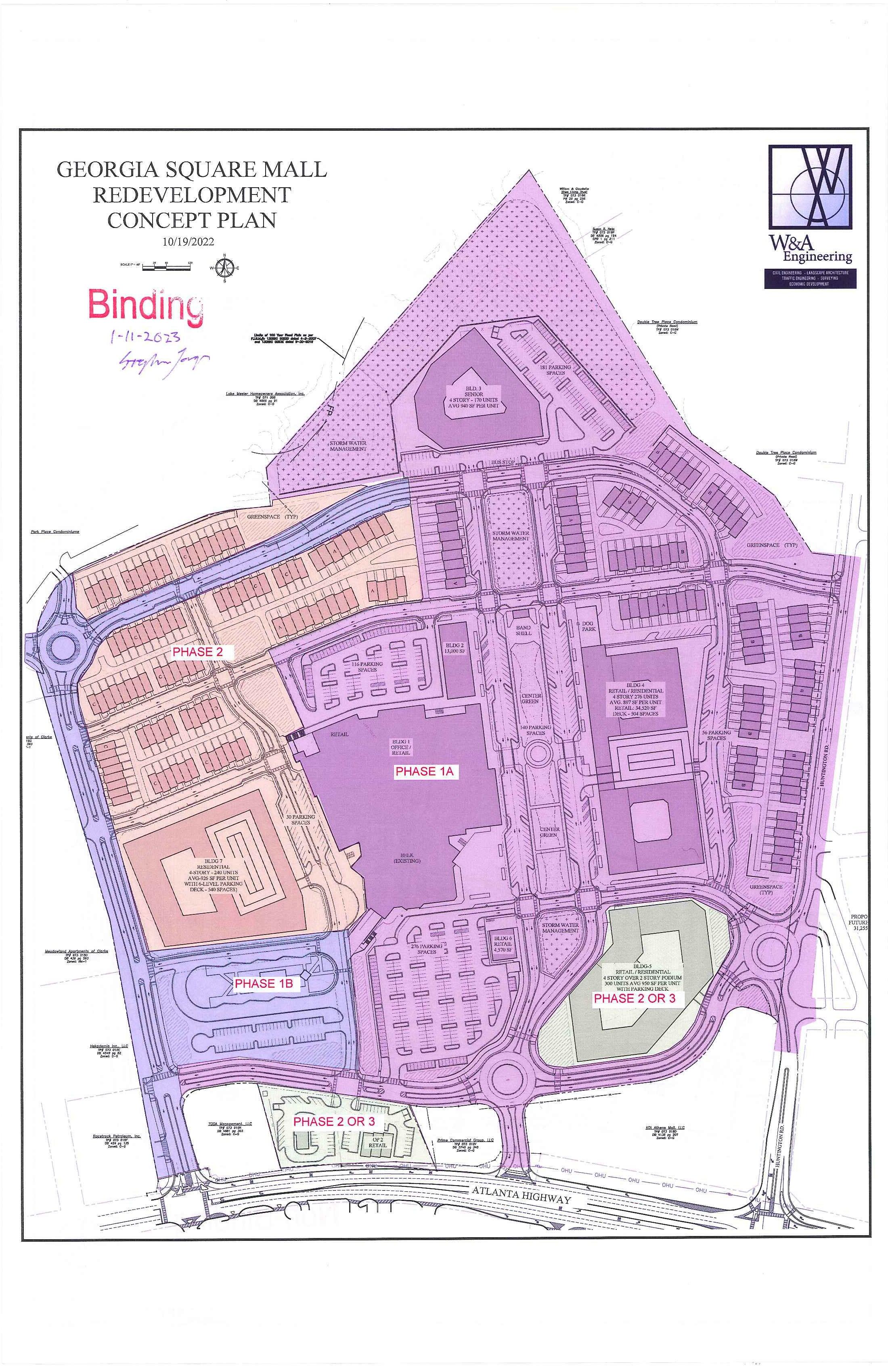
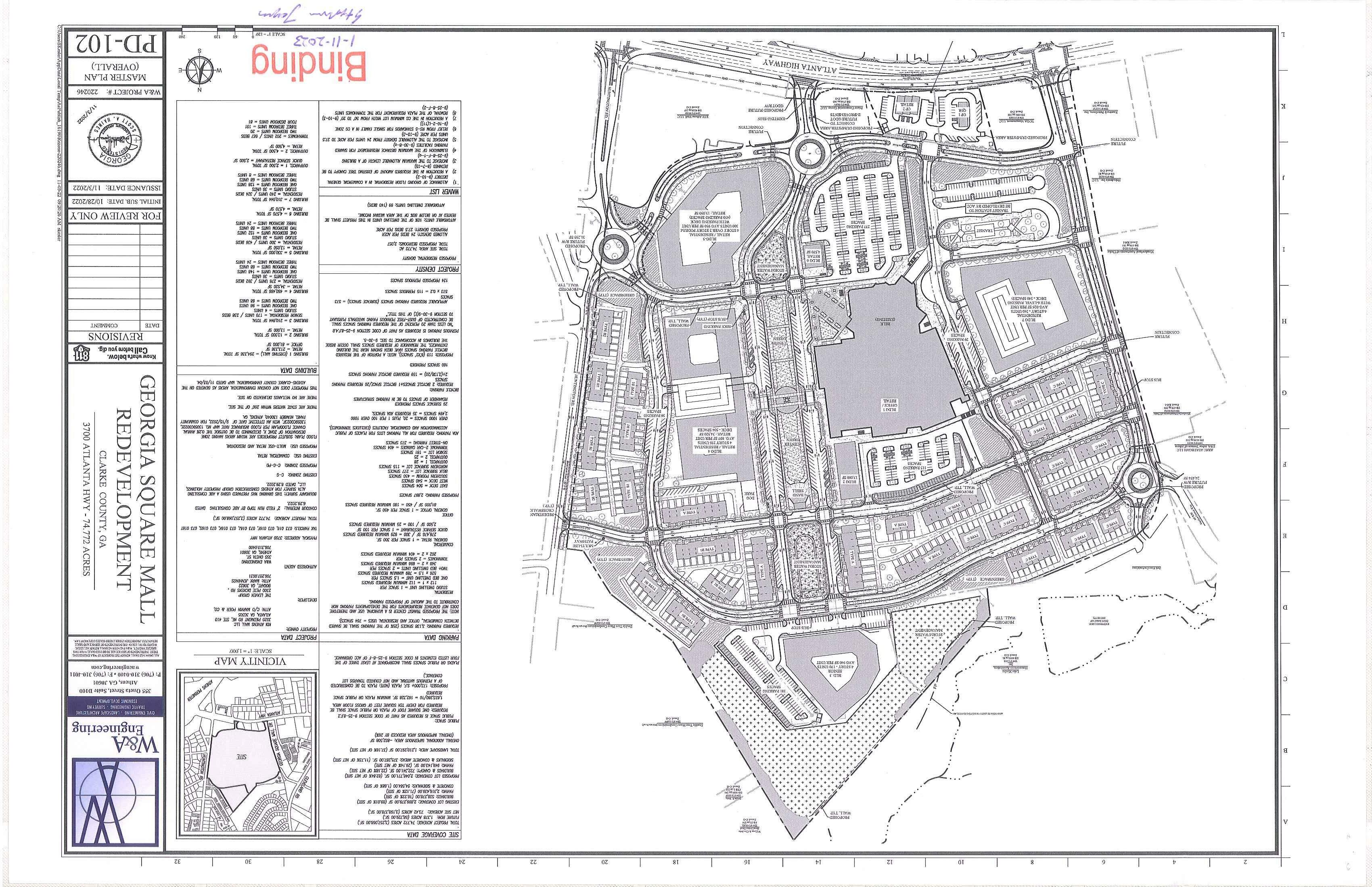
The proposal is to rezone the site t o C-G (PD) (Commercial-G e neral , Planned Development) for redevelopment of th e Georgia Square Mall site and associated outparcels. The proposal includ es demolishing two sections ofthe existing Georgia Square Mall totaling approximately 63% of the 791,000 sq. ft. structure. Specifically the former Sears store in the western wing of th e mall and the eastern portion beyond Belk would be demolished. The remaining 294,000 sq. ft. would include the Belk and renovate d space for commercial and office uses. In ad dition to the mall demolition and r e no vation, the propo sal includ es a total of 1,188 housing u nits (2 ,057 b edrooms) and 72,000 sq . ft. of new commercial space. See the table on the following page for building details:
2
B "Jd" D t T bl 1 Ul mg a a a e
Buildings (see site plan for location)
Square Footage I Un its Building 1 294,336 SF Retail 213,336 SF Office 81 , 000 S F
I Building 2 ,13 ,000 SF
Bu ildin g 3 2 10,844 S F
Senior Residential Total 170 units I 238 bedroo ms Stud io 4 units

One-Bedroom 98 units Two-Bedroom 68 units
Building_ 4 460 ,4 86 S F
Retail 34,520 SF
Residential Total 276 units I 392 bedrooms Studio 36 units
One-Bedroom 148 units Two-Bedroom 68 units Three-Bedroom 24 units
Building 5 330,000 SF
Retail 13 , 050 SF
Residential Tota l 300 units I 436 bedrooms Studio 36 Wlits One-Bedroom 15 2 units Two-Bedroom 88 units Three- Bedroom 24 units
I Building 6 , 4 ,57 0 SF
Building 7 310 ,044 SF
Res idential Total 240 units I 324 bedrooms Studio 36 units
One-Bedroom 128 units Two-Bedroom 68 units Three-Bedroom 8 units
2,500 SF
uick-Serv ice Re staurant 2,500 SF
I Outparcel 2 ,4,500 SF
Townhome s 202 units I 66 7 bedroo m s Two-Bedroom 20 units
3
Three-Bedroom 101 units
Four-Bedroom 81 units
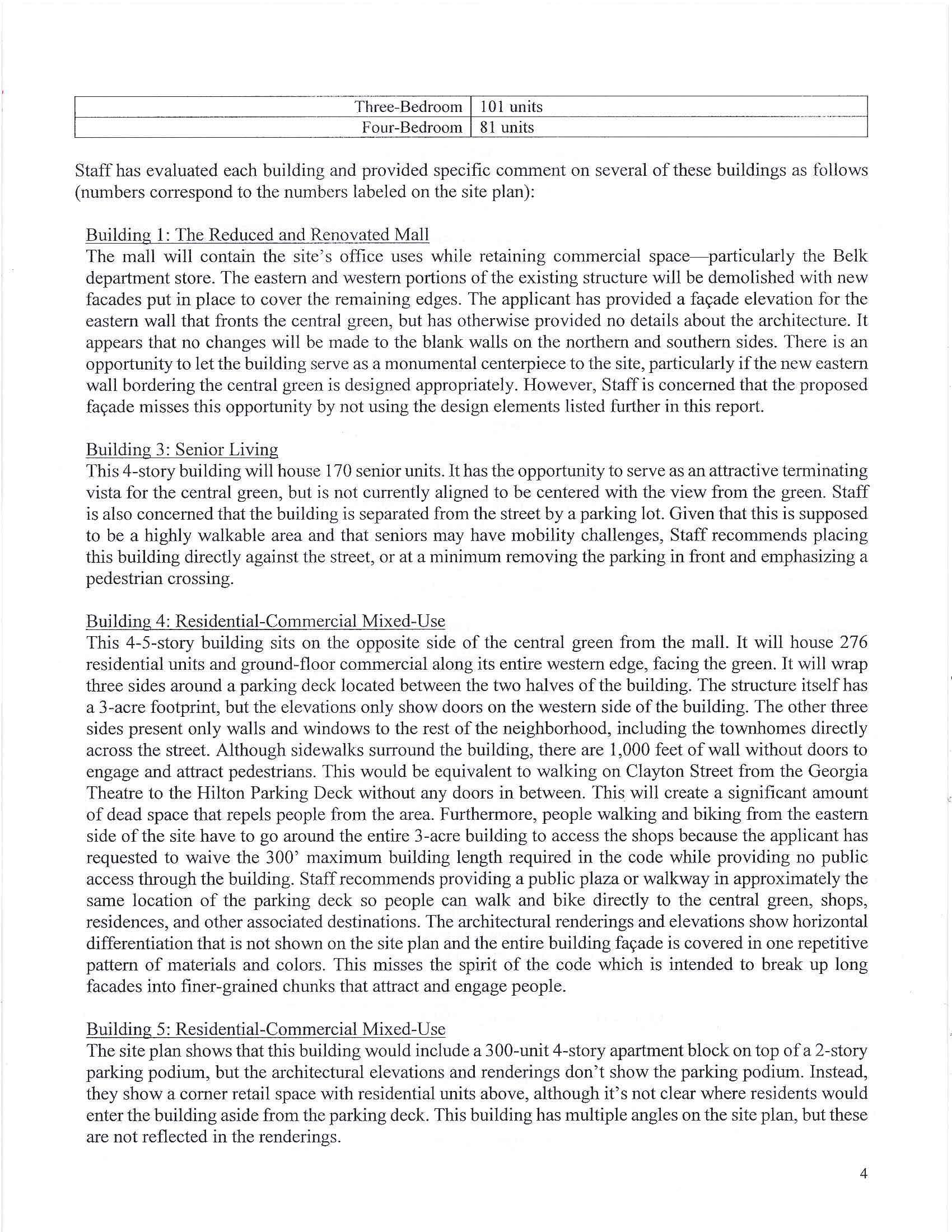
Staff has evaluated each building and provided specific comment on several of these buildings as follows (numbers correspond to the numbers labeled on the site plan):
Building 1: The Reduced and Renovated Mall
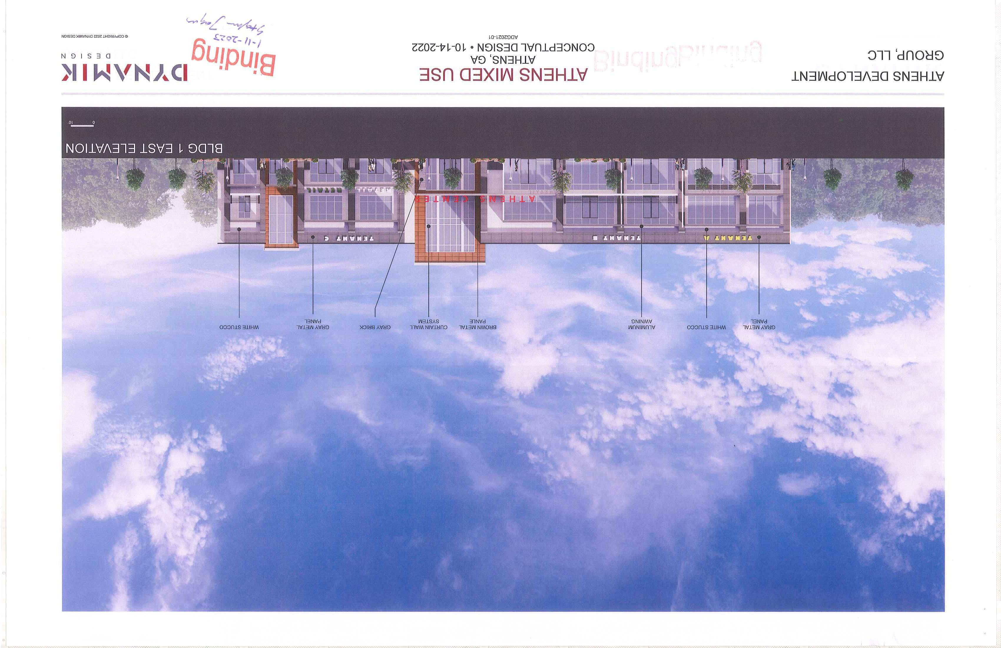
The mall will contain the site's office uses while retaining commercial space-particularly the Belk department store. The eastern and western portions of the existing structure will be demolished with new facades put in place to cover the remaining edges. The applicant has provided a fat;ade elevation for the eastern wall that fronts the central green, but has otherwise provided no details about the architecture. It appears that no changes will be made to the blank walls on the northern and southern sides. There is an opportunity to let the building serve as a monumental centerpiece to the site, particularly if the new eastern wall bordering the central green is designed appropriately. However, Staff is concerned that the proposed fa<;:ade misses this opportunity by not using the design elements listed further in this report.
Building 3: Senior Living
This 4-story building will house 170 senior units. It has the opportunity to serve as an attractive terminating vista for the central green, but is not currently aligned to be centered with the view from the green. Staff is al so concerned that the building is separated from the street by a parking lot. Given that this is supposed to be a highly walkable area and that seniors may have mobility challenges, Staff recommends placing this building directly against tbe street, or at a minimum removing the parking in front and emphasizing a pedestrian crossing.
Building 4: Residential-Commercial Mixed-Use
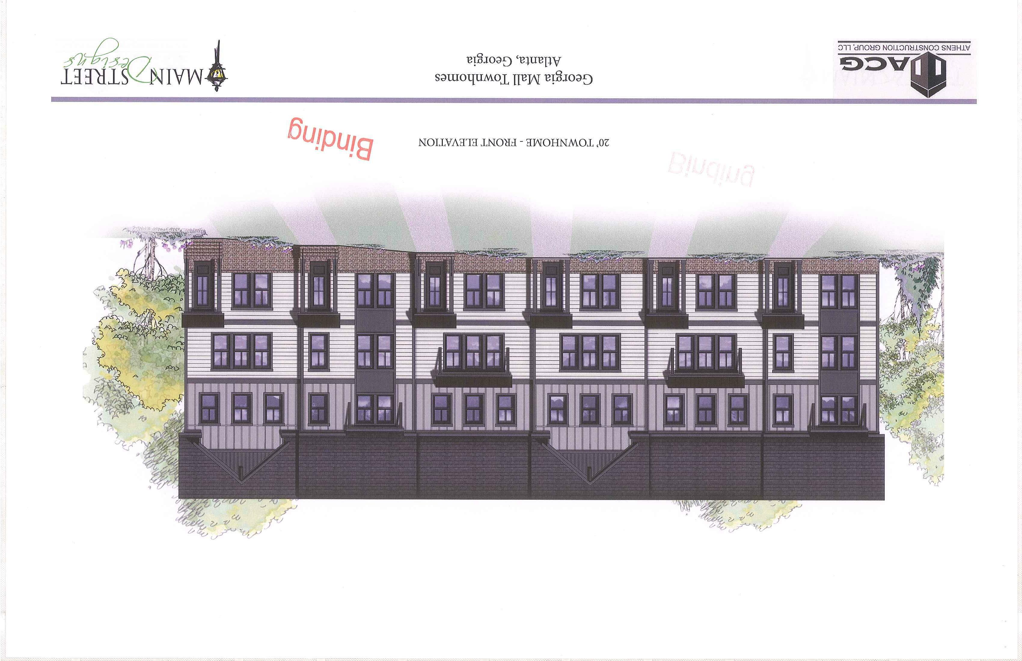
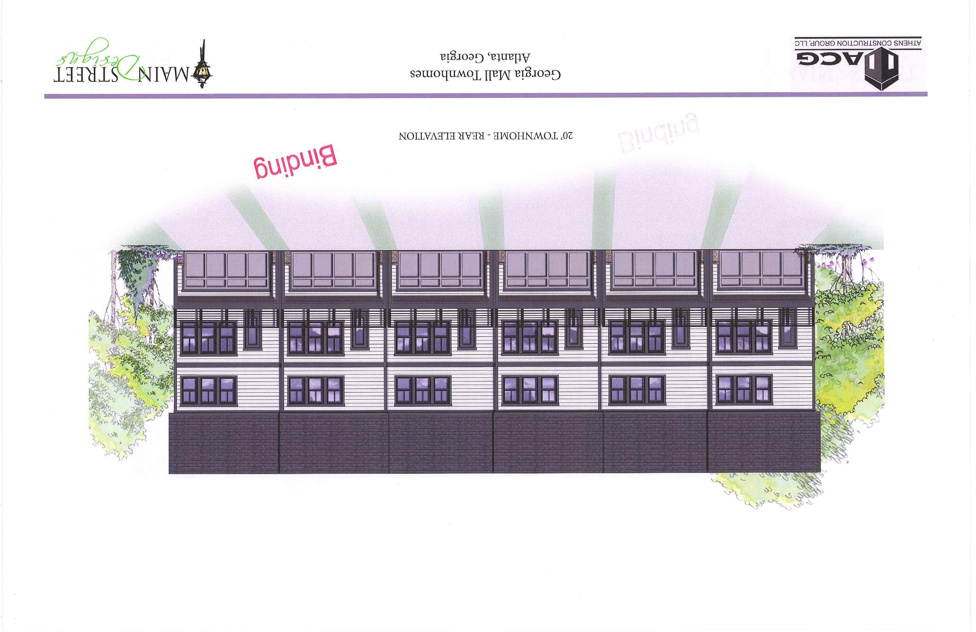
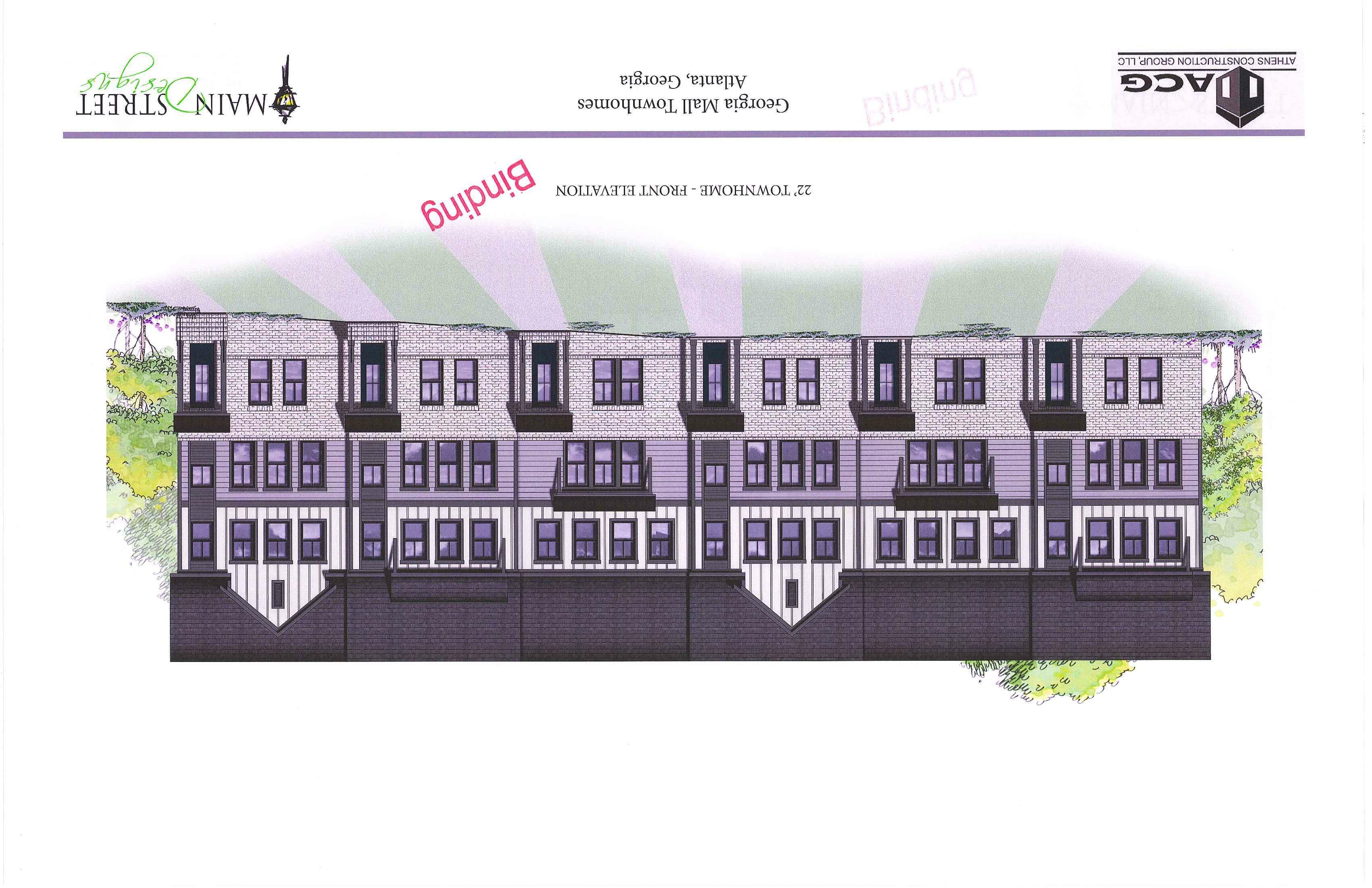
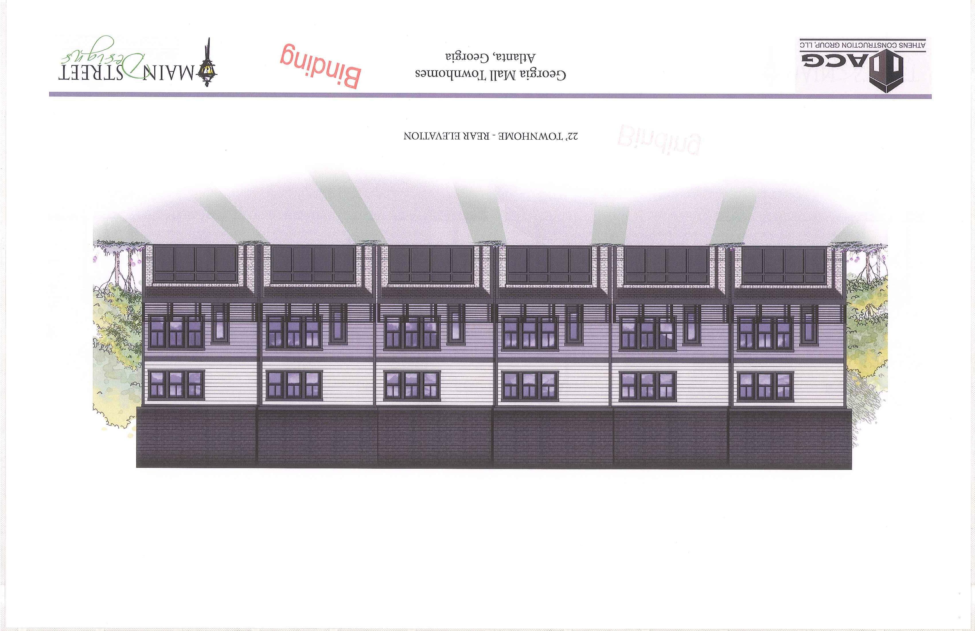
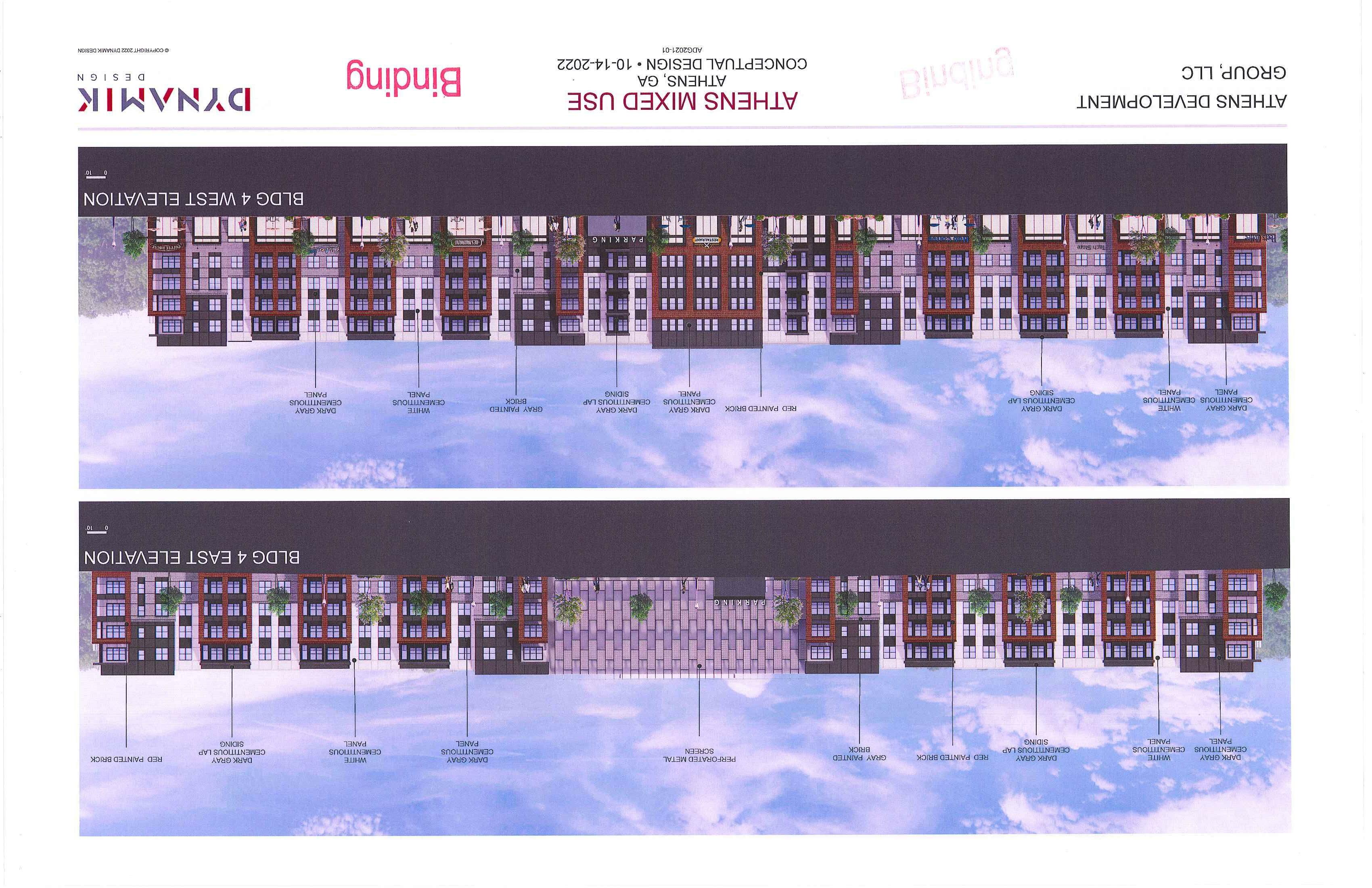
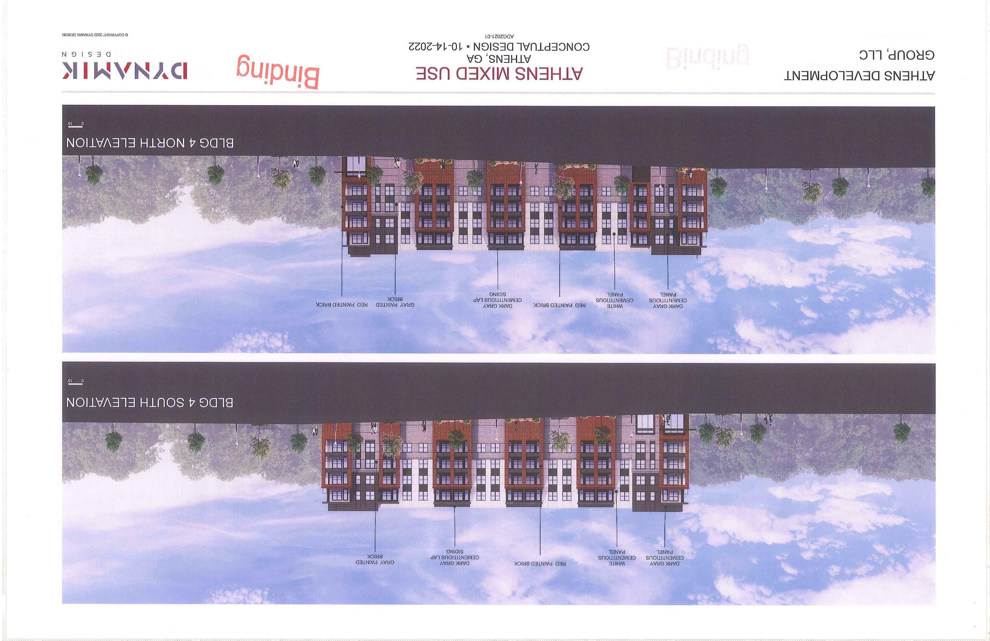
This 4-5-story building sits on the opposite side of the central green from the mall. It will house 276 residential units and ground-floor commercial along its entire western edge, facing the green. It will wrap three sides around a parking deck located between the two halves of the building. The structure itself has a 3-acre footprint, but the elevations only show doors on the western side of the building. The other three sides present only walls and windows to the rest of the neighborhood, including the townhomes directly across the street. Although sidewalks surround the building, there are 1,000 feet of wall without doors to engage and attract pedestrians This would be equivalent to walking on Clayton Street from the Georgia Theatre to the Hilton Parking Deck without any doors in between. This will create a significant amount of dead space that repels people from the area. Furthermore, people walking and biking from the eastern side of the site have to go around the entire 3-acre building to access the shops because the applicant has requested to waive the 300' maximum building length required in the code while providing no public access through the building. Staff recommends providing a public plaza or walkway in approximately the same location of the parking deck so people can walk and bike directly to the central green, shops, residences, and other associated destinations. The architectural renderings and elevations show horizontal differentiation that is not shown on the site plan and the entire building fat;ade is covered in one repetitive pattern of materials and colors . This misses the spirit of the code which is intended to break up long facades into finer-grained chunks that attract and engage people.
Building 5: Residential-Commercial Mixed-Use
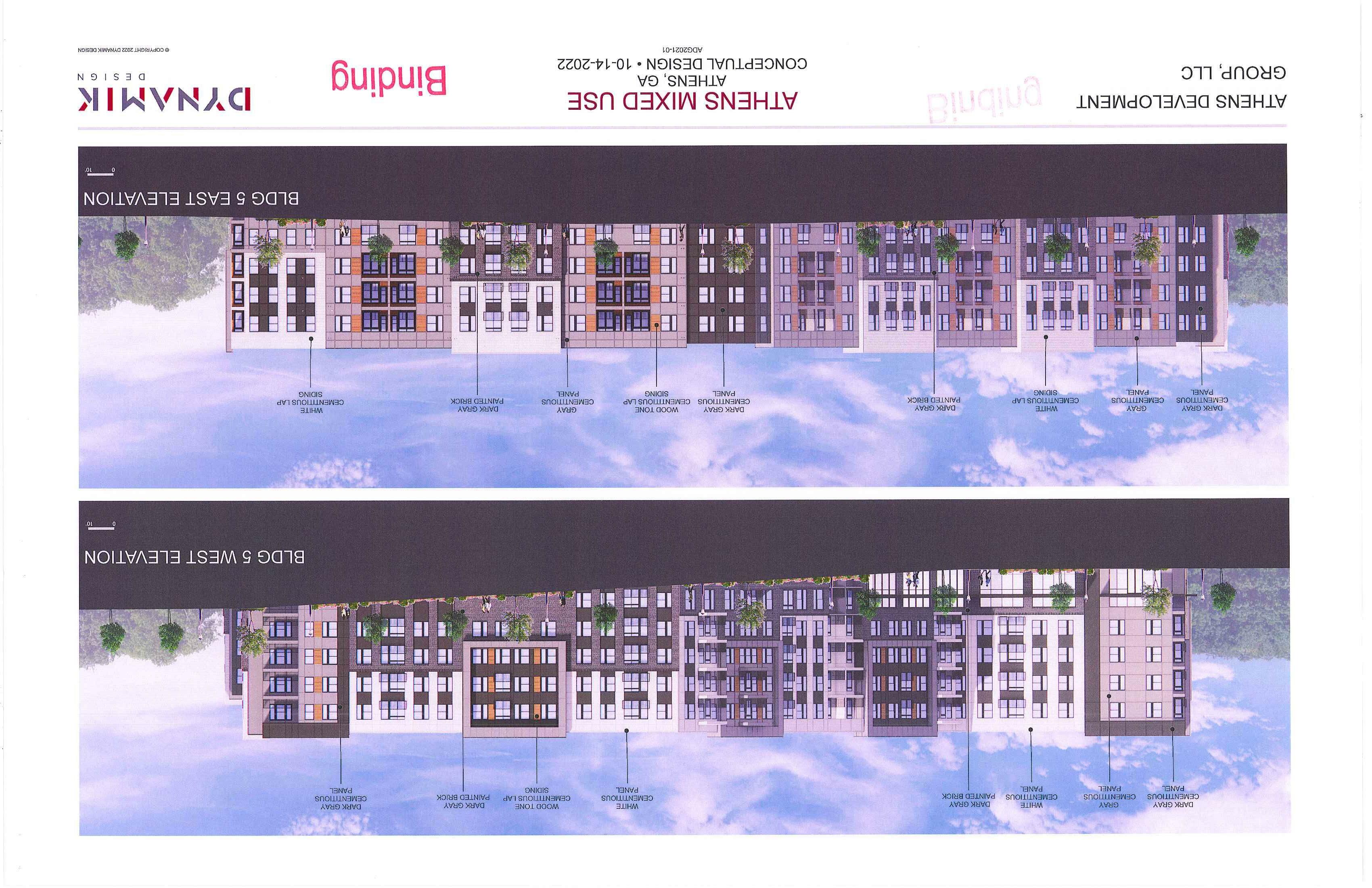
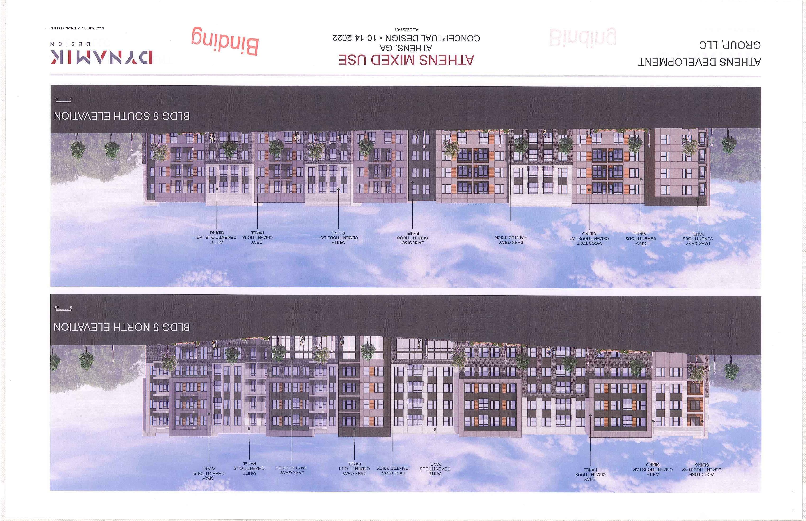
The site plan shows that this building would include a 300-unit 4-story apartment block on top of a 2-story parking podium, but the architectural elevations and renderings don ' t show the parking podium Instead, they show a comer retail space with residential units above , although it's not clear where residents would enter the building aside from the parking deck. This building has multiple angles on the site plan, but these are not reflected in the renderings.
4
Building 7: Res idential Apartment Block
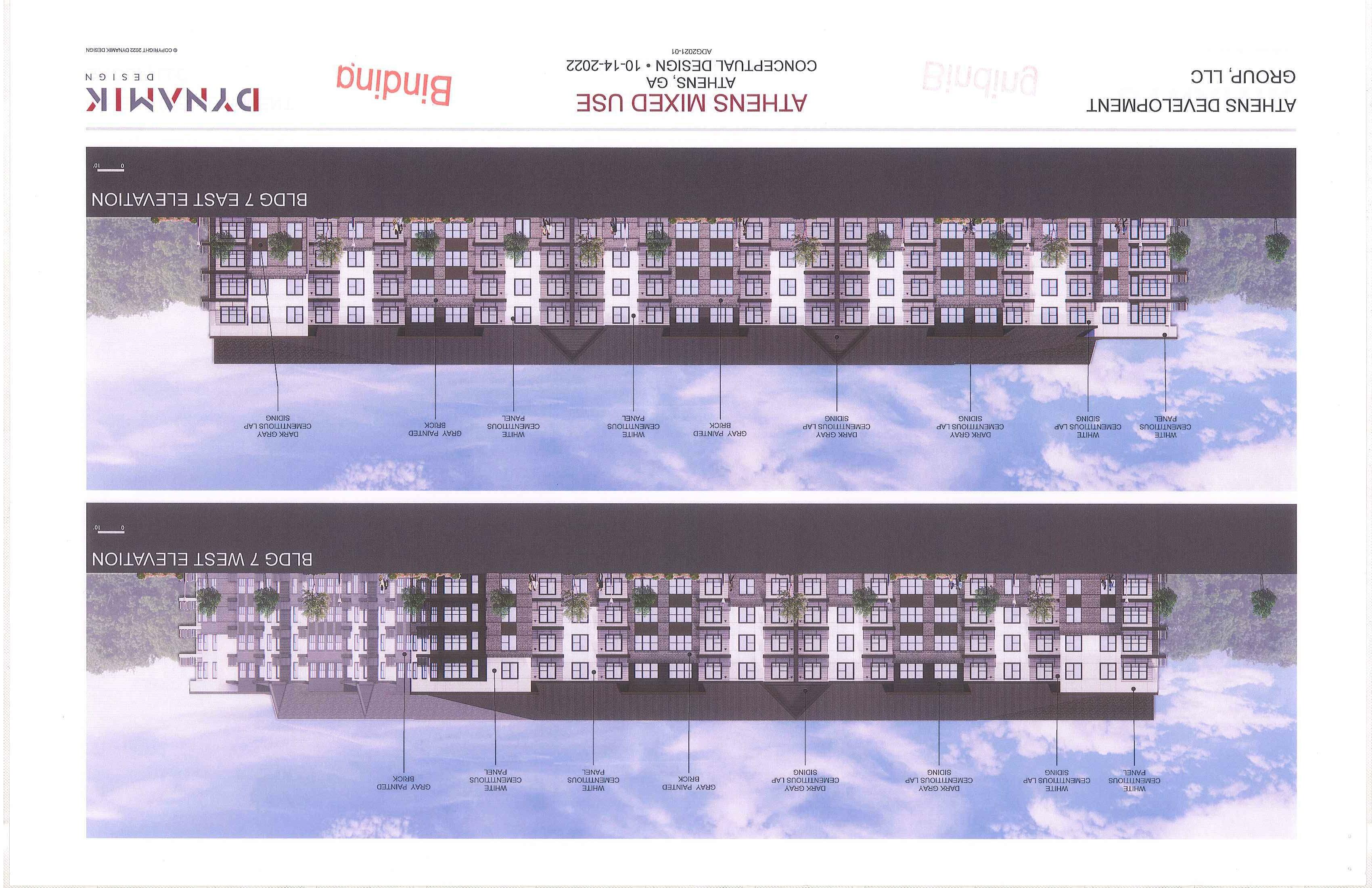
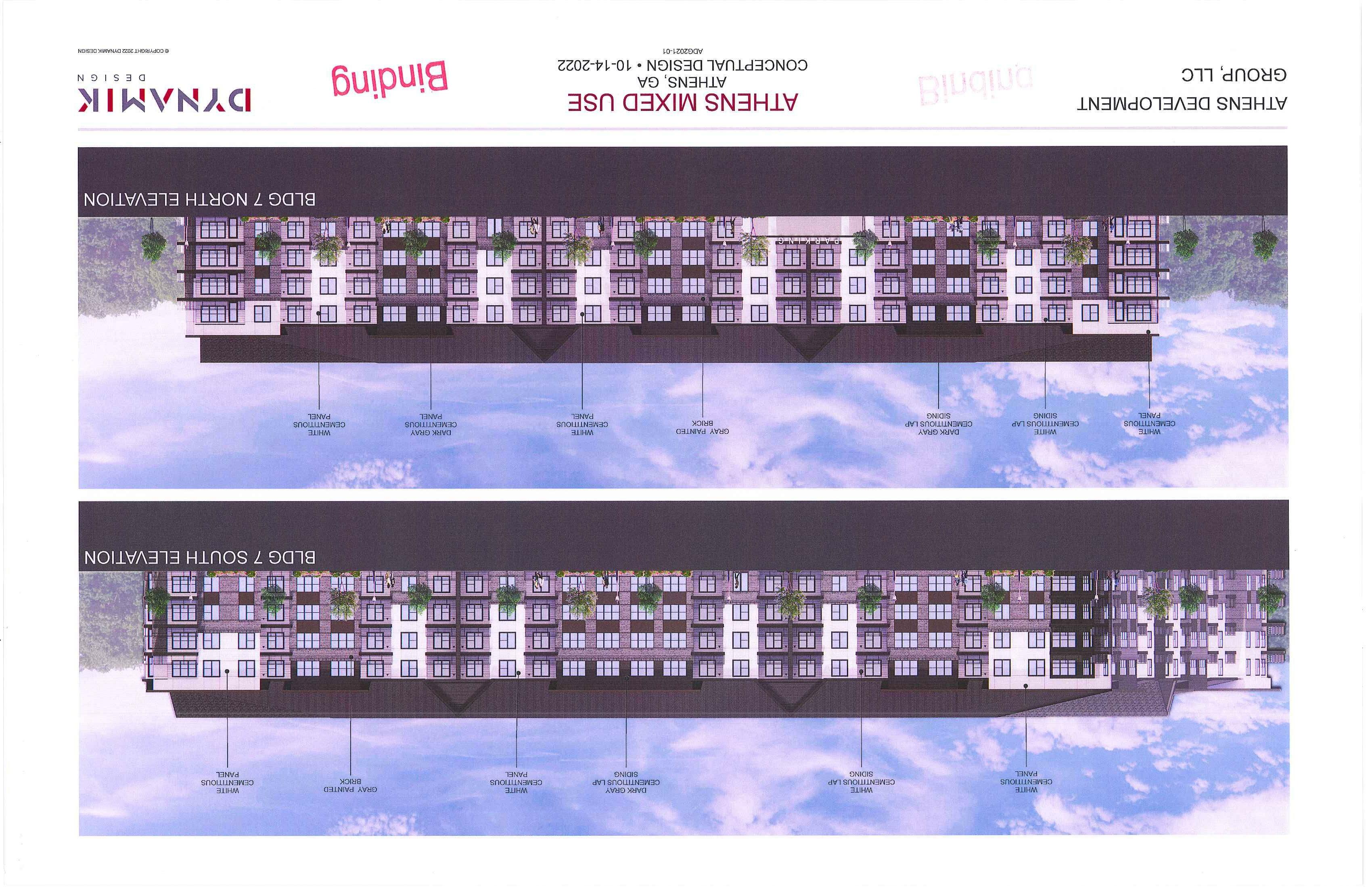
Bui lding 7 has a s imilar lack of detail as B uildin g 5. The difference is that Building 7 includes a 4-story, 240-un it apartment structure wrapped around a 540-space , 6-story parking deck. The applicant may expect these extra spaces to se rve the mall , but no sidewalk is s hown connecting this building to the bl ock it s its on or the mall. Wit hout this connection these spaces appear to be excessive. This bui lding has approximate ly t he same large footprint as the Mark building that sits at the comer of Oconee and Wilkerson Streets. T h e renderings appear to show on ly a couple of entry points, so the same comme nt about Bu ilding 4's lack of doors applies here. This building along with the adjacent townhomes forms part of Phase 2 that is scheduled for constr uction at a to-be-determined date. Staff supports the density proposed for thi s section, but sees opportunity to modify the design to include replacing the townhomes and block-scale apartment with a variety of"Missing Midd le" housing types and mov ing the parking deck to the 11 5-space parking Jot next to the mall.
Outparce ls : Quick-Service Restaurant and Retail
The applicant is propos ing to demolish two empty commercial buildings and replace them with a potential 2,500 sq. ft. quick- service restaurant and 4,500 sq. ft. of unspecified generic retail spaces. Co mbined, the lots are approximately 66,000 sq. ft. , and approximate ly 59, 000 sq. ft. are d evo ted to parking, landscaping, and s idewa lks. If one were to divid e the site into "p laces" that are destinations for people (e.g. bu ildings, plazas , gardens, etc.) and "non-places" that are the padding between destinations (e.g. parking lots, land scapin g, highways, etc.), the ratio of"place" to " non-place" is significantly weighted in favor of"nonplaces." "Non-places" deliver very little taxable value to the public compared with " places," and they tend to spread "places" out to the point where people are dependent upon automobiles to travel in between destinat ion s . Staff recommends that the applicant consider reducing the amount of " non-place"particularly through s haring parking- and adding add itional "places" to make the most of this site.
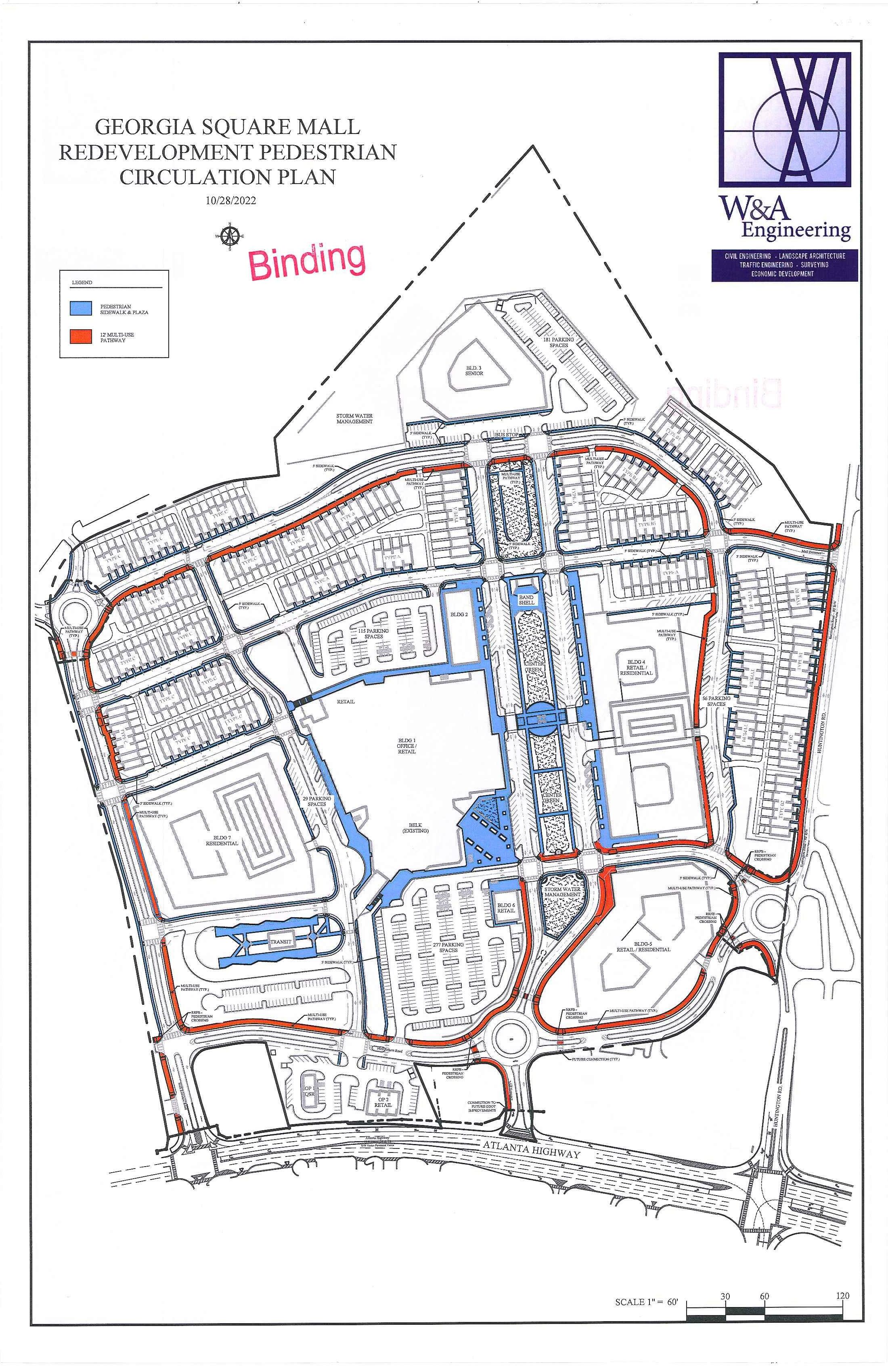
T he applicant has developed a street network for the site whi le maintaining the five existing access points between th e subject property and adjoi ning streets, including two connections to Atlanta Highway, two connection s to Huntington Road, and one connection to Marilyn Farmer Way. Several connections wou ld be converted to roundabouts. The app licant has also proposed a multi-use path and sidewalks throughout the property to provide access for wa lking and biking.
In addition to the buildings and streets, the applicant is reserving space for a larg e tran sit station (to be constr ucted by Athens-C larke County in the next three years), a central green, stormwater management areas, two surface parking lots, and add itional on-street parking. Overall the applicant is proposing 2,897 parking spaces, which is above the minimum that the y are required to deliver.
T he project would be developed in three phases with Phase One broken into two parts as quoted from the applicant's r eport:
Phase 1: Approximately 68% of the site area will be developed in the first phase. Due to the compl exiti es of redeveloping the site while maintaining busine ss at the existing mall, the first phase shall be divided into two sub-phases.
Phase lA: Includes rehabilitation of the existing mall area adjacent to Belk for use as office space The construction of 97 fee-simple townhome units, 446 multi-family dwelling units and 52,000 square feet of new commercial/ retail space. Improvements to be constructed during Phase 1A will be the center gree n area and the described amenities, plaza space, sidewalk portions of th e multiuse trails, two roundabouts and the stormwater management infrastructure.
5
Phase lB: Includes the site preparation of the transit station and the roadway improvements along the properties western side including the third roundabout. The cons truction schedule of the transit station will be determined by Athens-Clarke County.
Phases 2 & 3: Make up the remaining 28% of the total site area. These phases include the remaining feesimple townhomes and the remaining 620 multi-family dwelling units [Staff notes this should be 540 unitsJ. Timeline and configuration of the remaining phase(s) will be driven by market demand. The given outline of these phases is subject to change per market conditions.
COMPATIBILITY WITH THE COMPREHENSIVE PLAN
I. COMP ATJBTLITY WITH FUTURE LAND USE MAP
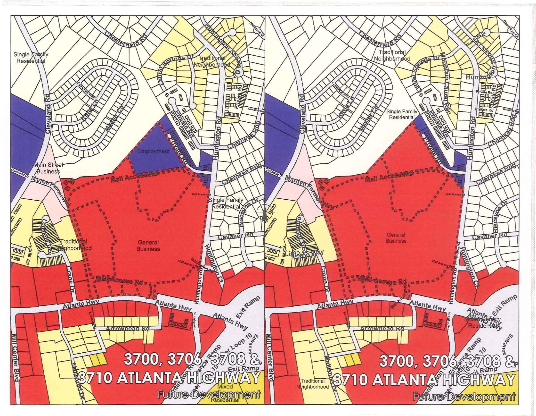
The Future Land Use Map indicates that the majority of the subject property , consisting of parcels 073 016, 073 016F, 073 016K, 073 016S, and 073 016T , currently has a General Business designation, which is described as follows:
General Business
These are commercial areas that serve a variety ofneedsfor the residents of the region. It is intendedfor small- and large-scale retailing and service uses that are auto-oriented, such as Atlanta Highway, Lexington Road and US 29 North. Pedestrian-oriented design is particularly appropriate when these streets contain neighborhood-shopping areas or are adjacent to multifamily housing or residential neighborhoods. Pedestrian circulation in these centers is a primary concern, therefore, connectivity within and to surrounding areas should be encouraged. Internal pedestrian walkways should be provided from the public right-of-way to the principal customer entrance ofall principal buildings on the site. Walkways should connect focal points ofpedestrian activity such as, but not limited to, transit stops, street crossings, building, store entry points, and plaza space. Walkways shall feature adjoining landscaped areas that contribute to the establishment or enhancement ofcommunity and public spaces The street level facade of these areas should have a scale and architectural elements that relate to pedestrians Buildings should be oriented to the street and corridors should be lined with street-trees. Small and medium s cale retail stores should frame the streets with large-scale retailers located behind with focus given to pedestrian circulation rather than automobiles. Parking lots should not be located at the street front and shared parking should be encouraged.
The Future Land Use Map indicates that the tax parcel 073 016J, located at the northernmost edge of subject property, currently has an Employment Center designation , which is described as follows:
Employment Center
These are areas of industry, office, research parks, and mixed uses Large-scale employment areas, which include large industrial areas, manufacturing, office parks, and research centers, are incompatible with housing. Smaller-scale employment areas are appropriate to be in close proximity to a neighborhood area. Design standards regulating building placement, landscaping, and buffering should apply. Small amounts ofretail may be compatible in some areas.
The proposed C-G (PD) zoning is compatible with the existing General Business designation, but is incompatible with the Employment Center designation, per the Compatibility Matrix in Chapter 9-4.
6
Therefore , the request req uires am ending the Future Land Use Map d esignation for that parcel to General Business.
Many of the most automobil e-centr ic commercial propertie s in A th ens-C larke Co unty , including th e mall , are classified as a General Business Future Land Use. However, th e d esc ription of this land use envisions a tran s iti on to a more urban and walkable form as th ese prop erties are r ede ve loped. The m a ll prese nts a large-scale ex ample of auto -centric deve lopment, with 71% of the 75-acre s ite covered in asphalt while the buildin gs cove r just 16% of the site. However, this site also presents th e greate st opportunity to tran sfor m a dec lining node of commercial mon oc ultur e into a nei ghborh oo d complete w ith a vari ety of opportunities to l ive, work, and play.
The mall is designed a nd scaled exclusively for automobile acces s with the building bein g compl e te ly surrounded by g iant surface p a rkin g lot s. There ar e no s idewalks or bike la nes to provid e access. A person would need to cross an oversized four-lan e ring road and hundreds of feet of featurel ess heat-radiatin g car storage area to get to the front doors. T hi s sc ale creates an environment where peo ple fee l small , expo sed , and unw elco m e. P eople who may have limited access to a car, including low-income household s, the elderly, children, a nd p eo pl e with di sa bilities are particularly disadvantaged w h en trying to ac cess thi s si t e. With proper attention paid to the p edestrian-ori en ted design elements described in th e General Bus in ess Future Land U se, thi s s ite can be transformed into a human-scaled environment where p eo ple are the focus of the desi gn rather tha n cars.
The proposal include s a new tree-lined stree t network and places its front door s close to the se stre e ts-a significant improvem ent over th e existing site. However, Staff have noted missed opportunities to create an exemplary pedestrian-oriented e nvironmen t. For example, the block-scale apartment buildings (Bldg. 4 , 5 , and 7) have hundr e d s of feet of wall on their side s and r ea r that have no door s to se rve o r interest people in wal k ing b y. The adjac ent sidewalks in these sections will likel y go unus ed and create dead spacesomething the Ge neral Busin ess Future Land Use is trying to avoid. Additional examples of mi ssed opportunities include a front drive (as one enters dire ctly from Atlanta Highway) that is framed by a parkin g lot o n one s ide, and a featurele ss lawn on the other. Ideally , buildings should line this entrance with fr equent do ors to serve and draw peopl e into the site. The current desi g n treats thi s front door as the rear end. On th e other en d of the main thoroughfare, the senior hous ing in Building 3 is separated from its bus s top and street b y a row of parking. Best de s ign practice would not force people with potential mobility chaJlenges to navi gate a parkin g lot first in order to ac c ess the rest of the site. The center green is flank e d by four vehicle travel lan es and do z ens of parking spaces. In order to achieve a pedes trian-oriented place, the g reen could b e exp anded b y u s ing a single travel lane on each side instead of two or by reducing th e parking.
II. COMPATIBILITY WITH COMPREHENSIVE PLAN POLICIES
The following are relevant 2 018 Comprehensive Plan policie s :
• Increase the supply and variety of quality housing units, at multiple price points, in multiple locatio n s, to suit the needs of a vari ety of hou seholds.
• Increase acce ss to affordable hou sing.
• Support the creation of quality se nior housing.
• Infill and redevelopment should b e prioritize d over greenfield expansion.
• Create nodal development tied to transpmtation, healthcare, schools, jobs , workforce , and housing.
• Re- examine zo ning standards to ensure that they are deli v ering on community objectives such as affordable housing, provi sion of parkland and greenspace, environmental sustainability, etc.
• Improve safety and accessibility for p eo ple walking, biking, and busing around Athens.
7
_
• Prom o te intra - and inter-connectivity within and between neighborho od s wh ile di scouraging cul-desac dev elopm e nt. This applies to both ve hi c ular and pedestrian pathways an d m ay not a lwa ys r e quire formal , paved improvements when ass oci ated with walkability.
• E n s ur e that n e cessary infrastructure (streets , s idewalks, utilities, etc.) is provided for all neighborh o ods.
• Decrease automobile trips by providin g and incentivi zing altemative tran sp o rtation mod es .
• Provide saf e , accessible, and attractive multi-modal transportation options throughout Athen s .
• Incre a s e the availability ofwell-payingjobs, e s p ecially for those in poverty.
• Utili z e b est practices for the attraction and retention of business and industry, especially in the followin g target sectors: a) Craft Beverages b) Creative Economy c) Bio s ci enc e d) Healthcare and e) Advance d Manufacturing
• Incenti v ize and incorporate the mis and green space into aU new deve lopment s.
• Increase acce ss to green space and clean air to improve people's health
• E ncourage the u se of environmentally s u s tainabl e construction techniques , m a teri a ls, and buildings.
• E ncour age th e creation of publicly accessible gathering spaces within n e ighborhood s and development projects. _
• Identify a reas that could potentially be developed for unique neighborhood s with s maller houses and a cohe s iv e theme .
This project touches many areas of the Comprehensive including hou s ing, trans portation , environmental preservation,- economic development , and urban design. The bas ic s of the proposal, including building a variety of housing units , redeveloping an infill site , creating nodal development, locating near transit service, increasing greenspace, and providing necessary infras tructure help bring this s ite into a !ig nm e nt with the Comprehen sive Plan However , there are missed opportuniti e s for further alignm ent th at a s ite of this importance and magnitude should seek out.
While there are a variety of housing units available , including senior hou sing and unit s reserved lor affordability, th e re are only two types of hou s ing provided- attached single-family and block- scale midri s e apartm ents. There is a noticeable Jack of " Mi s sing Middle" housing types in a location that is ideally position e d to incorporate these housing types into a new neighborhood at the start . Specifically, there is a unique opportunity to build the larger " Upp e r Mis s ing Middle" buildings that may have up to 2 0 units while retaining a walkable human-scaled form. The key advantages of this pattern compared ag a in st the pattern of the current townhome and block-scale apartment proposal, includes distributing the density more evenly across th e site , activating additional street frontage s with more front doors, increas ing the menu of choices for re s idents and designers , and increasing the resiliency of the project through fine-grained incremental dev elopment.
It is vital to reco gni z e that the mall is being considered for redevelopment in large prui because it was too fra g ile to Last b eyond one generation . The building was custom-built for a single commercial busine s s model that was not fl exible enough to adapt to changing market dynamics. In compari son, the collection of individua l prope rties that make up downtown have a much easier time finding 2 "d , 3rd , or even 4th lives becaus e of their a daptabl e size , construction, and diversified ownership . The failure of on e bu sin ess-even a large one- in the traditional downtown pattern is less likely to wipe out adjacent bus inesses than the loss of an anchor store at the mall.
There ar e s imilar benefits to meeting the hous ing need with a collection of different types of housing instead of one large apartment building or one type of single-family house. In the cas e of this proposal , Buildings 5 and 7, where the majority of the apartments will be , are scheduled for construction in Phases 2 and 3
8
"subject to change per market conditions. " There is unce11ainty as to whether these buildings will be constructed in part because constructing and financing a building with hundreds of units is inherently riskier than constructing and financing a building with a couple dozen units. Distributing hundreds of apartment units across a dozen or more buildings instead of two, could reduce the risk, allow construction to start sooner, and open those units to would-be residents quicker than if they have to wait for the market to justify a 200-un it apartment building. This point is best explained in the following illu stratio n:
From a transportation standpoint, S taff supports the addition of a street network to th e site, especia ll y the alley-loaded townhom es The proposal dramatically improves access , particularly for peop le walking, biking, or riding transit, as called for in the Comprehensive Plan. However, the major transit station is p laced on the edge of the property and is not well-integrated into the site . There are bike racks and bike access through a multi-use path.
The Co mprehensive Plan calls for adding art and greenspace into new development. The applicant has not shown any plans for art, but has added greenspace and plazas. This i s certainl y an upgrade over the ex isti ng expanse of asphalt, but Staff has not ed certain de.ftciencies that will li kely preven t this gree nspace from providing the full sca le of intended benefits. While there are greenspaccs scattered around the 75-acre site , it appears that only the center green is intended for people to use. Based on the lack of programmed design e leme nts , the rest of the greenspace appear to be nothing more than leftover land after the bui l dings have been laid out. On a s ite this large, residents will need smal ler gree n s, courtyards, and pocket parks-in addition to the central green- to provide sufficient relief from the urb an envirorunent. Importantl y, these greenspace s need to be integrated with the blocks and hav e e lements that wi II attract people to use them rath er than merel y see them as they mov e past. Such elements include defined edges that provide attractive and secure space for peop le to gather, shade , seating , and may include child-fri endly play spaces. The center green itself is positioned to be the focal point of the project, but it appears to be more ornamental than recreational. This space could be a longer, greener version of the recently estab lished College A venue Square, but is not currently designed to attract people to linger and e njo y the area. It may also benefit from programming to fully act ivate the space, as the City of S uwanee, Georgia has done with its Town Center Park. The applicant states that so me of the stormwater management areas are des ign ed as dual purpose amenity spaces. However, th e spec ifi c character of these areas is not clear on the site plan. The main question is whether these areas wi ll have stand in g bodies of wat er that can serve as attractive featur es for people to gat h e r or merely be wetter, le ss usab l e versions of the center green.
The app licant has stated that they will be incorporating green building technology into the s ite including laying conduit for future EV charging st atio n s and roof-mounted so la r panels. However, there are other aspects of green design that the applicant could also emplo y including, but not limited to , reducing parking , reducing, reusing , and properly disposing of demolition was te , and constructing buildings that are fl exible enou gh to serve multipl e uses beyond the first li fe cycle-unlike th e mall s tructure that is being r ep laced.
Finally, there is an opportunity to create hi g h quality architecture with a cohesive theme for this site. Architecture has an outsized impact on the quali ty of human habitat, and can make a significant difference in the succes s or failure of a project of this size and scale. The field of cognitive architecture is discoveri n g that humans are biologically hardwired to gravitate towards buildings and places that have elements like:
A) Surfaces made out of wood , brick , or ston e in stead of glass , metal, or concrete
B) Proportions that are scaled for people rather than cars
C) Facades that stimulate the senses through things like detailed ornamentation and bilateral symmetry
D) Connection to nature (e.g. street trees, window boxes, garden s, etc ) Humans in stinctuall y find places with these e lements more attracti ve and lo ve ly. Places that are instinctually attractive and lo vely are more lik ely to be successfu l and resilient because people are drawn to them again
--···:-"
9
and again even as the u ses change. The ma ll did not last, in part, beca use it lacked this innate attractivene ss There is now an opportunity to correct thi s overs ig ht , but the propo sal 's arch itec ture largely mi sses these e lemen ts--e specia ll y the la r ge mu lti-fami l y and mi xed-u se structures . T hi s is perhaps the onl y area of th e Comprehensive Plan where the propo sa l is out of a li gnme nt with the Plan. In general , the current proposal adheres more close l y to the Compreh e nsi ve P l a n than previous iterations. However , Staff has specified additiona l opportu nities to bring th e proposal into even closer a li gnmen t with the P l an.
COMPATIBILITY WITH ZONING MAP AND ORDINANCE STANDARDS
I. COMPATIBILITY WITH ZONING MAP
The purpose of t hi s request is to rezone four parcels from C-G (Commercial-General) to C-G (PD ) (Commercial-General, Planned D evelopm e nt) for a residentia l, commerc ial , and office mixed-use d evelopment. T he area immed iate ly s urr ounding th e subject property is comptised of C-G (Co mmercialGeneral ), RS-25 (Single -Fami l y Re s id e nti al), RM- 1 (Mixed-D e n sity Residential), C -0* (CommercialOffi ce wit h Conditi ons), and RS-1 5 (Sing le -Fam il y Res iden tial ) zon in g di s tri cts . The proposal does not change t h e base C-G zoni n g o f the s ubj ec t prop erty. Therefore, approva l wou ld not create an isolated zo ning district, and is ge nera ll y compatible with t h e zon in g map.
II. COMPATIBILITY WITH ORDINANCE STANDA RDS
A ll exemptio n s t o the zoning and development standards must be id e ntifi ed in the app lication prior to approva l of a binding proposal s ince t he development i s otherwise expected to adh ere to the o rdinan ce standards. The applicant has re quested the fo ll owing wa ivers:
1. Waiver from !he groundjloor commercial requirement ofSection 9-10-2
App licant's Purpose: Allows constr uc t ion of th e townhomes and exclusivel y residential apartment buildings.
Staff Opinion: The ground -fl oor requirement i s intended t o ens ure tha t th ere is street- leve l acti vi ty along th ese fr ontages. Given the scale of the si te, it is unre aso n ab l e to expect 75 acres of g round- flo or commer c ia l spaces . Walk-up residences can also provide th e interest and engagement that the Code is trying to create, and the applicant has provided that on man y of th e streets-with exceptions for specific buildings noted. Therefore , Staff su pports t hi s waiver.
2. Waiverfrom the density allowance of24 bedrooms per acre for C-G zones in Section 9-10-2
App licant 's Purpose: The appl icant i s seeking an overall d e n sity of 27 5 bedroom s per acre.
Staff Opinion: Staff supports in creased density at this l ocatio n because of its potential to serve as a n urban node. H owever, Staff i s co ndi ti oning it s support for the waiver o n the app li cant providing additio n a l types of hous ing beyond town homes and mid-ri se apartment b locks.
3. Waiver from the RS-5 sta ndards for single-family construction in a C-G zone in Section 9-10-2 (L1 1)
Applicant 's Purpose: Allows constr uction of the townhornes at a great er density .
10
Staff Opinion: Staff recognizes that r edevelopment of th is s ite requi res design flexibility that s upports a dditional density above what RS-5 sta ndards would a llow at this site. Therefore, Staff sup ports t hi s watver.
4. Waiver ji-om th e 50' minimum lot width in Section 9-10-3 down to 20'.
App li cant's Purpose: Allows construction of t h e townhomes.
Staff Opinion: St a ffnotes th at this waiver is unnecessary because the RS-5 standard s fo r si ng le-fami l y co nstru ction a ll ow minimum lot width s to be reduced to the requested 20 feet for sin gl e-family attache d units.
5. Waiver from the 300' maximum building length allowed in Section 9-25-B(F)
Applicant 's Purpose: Allows co nstruction of Building 4 in its current configurat ion.
Staff Opinion: Sta ff notes th at the block created by thi s building exceed s the 3-acre maximum in Secti on 9-25-8(C)3 and wo uld require an ad diti o nal wai ver. This waiver has not been requested and would not be s upported by Staff becau se large blocks create dead space and make it difficult to walk or bike to destination s . fo r these r easo n s, Staff does not s upp o rt th e waiver request ex p and in g th e maximum building len gth. The applicant stat es they need thi s extra length to match th e length of the mall fayade on the opposite s ide of the green. However, Building 4 's len gth exceeds the Mall' s l ength by approximately 80 feet. Furthermore, Building 4 blocks direct p edes tri a n access from the town hom es b y Huntington Road to the central gree n while placing a large ly unintelTupted doo r -less wa ll facing the town homes. Splitting Building 4 with a public pedestrian path would allow direct access and create an opportunity for a monumental terminating v is ta of t he new Mall fayade .
6. Waiver to remove the townhome lots from the plaza area calculation in Section 9 -25 -8(F)2.
Applicant's P urpo se : Reduces the imp erv ious s urfaces on the site.
S taff Opinion: The plaza requirem e nt is intended to provide attractive public gathering p laces in large developm ents. While Staff suppmis reducing impervious s urfaces, Staff does not support removing public gath ering places from lar ge- scal e developments. Staff does r ecognize that plazas m ay not be th e best fit for public gathering spaces among the townhom es, so Staff is co nditioning its support for thi s waiver on the applicant distributing public gathering spaces in th e form of public green s, sm a ll parks, or like de signs throughout the townhome blocks.
7. Waiver from the 200' maximu m di sta nce for shared parking requ ired in Section 9-30-8(A)
Applicant 's Purpose : The shar ed parking has been placed farther than 200 feet from th e buildings that are intended to use it.
Staff Opini o n: Staff had a difficult time evaluating this request since the app licant did no t specify where on the s ite plan the y are having difficulty meeting this sta ndard. The intent of th is stan d ard is to reduce parking minimums where the location allows parking to be efficiently shared between compat ib le uses (s uch as those w ith differin g p eriod s of de mand). Locating the shared parking too far from th ese u s es defeats th e purpose of the standard. Therefore, Staff does not su pport the waiver. Staff n otes that t he applicant h as created blocks in excess of the 3-acre maximum, and breaki ng up these blocks may allow
11
them to locate their parking closer to its assigned uses. lf the applicant can specify where they arc having difficulty meeting the standard, Staff can provide clearer direction on compliance, and may reconsider its position on the waiver.
8. Waiver from required conserved tree canopy standards of Se ction 8- 7-15
Applicant's Purpose: The existing tree canopy does not meet the minimum of I 0% required in the C-G zone. Therefore it is impossible to conserve canopy that doesn ' t exist. The applicant is planning to significantly raise the overall canopy coverage from its existing levels by planting more trees.
Staff Opinion: The ACC Arborist recommends approval of th e request. Therefore , Staff supports the WaiVer.
Code Compliance Issues :
In addition to the requested waivers Sta!Ihas found the following code compliance issues :
1. The applicant does not show that the apartments are complying with the 450 ' minimum square footage requirement of Section 9-15-15.
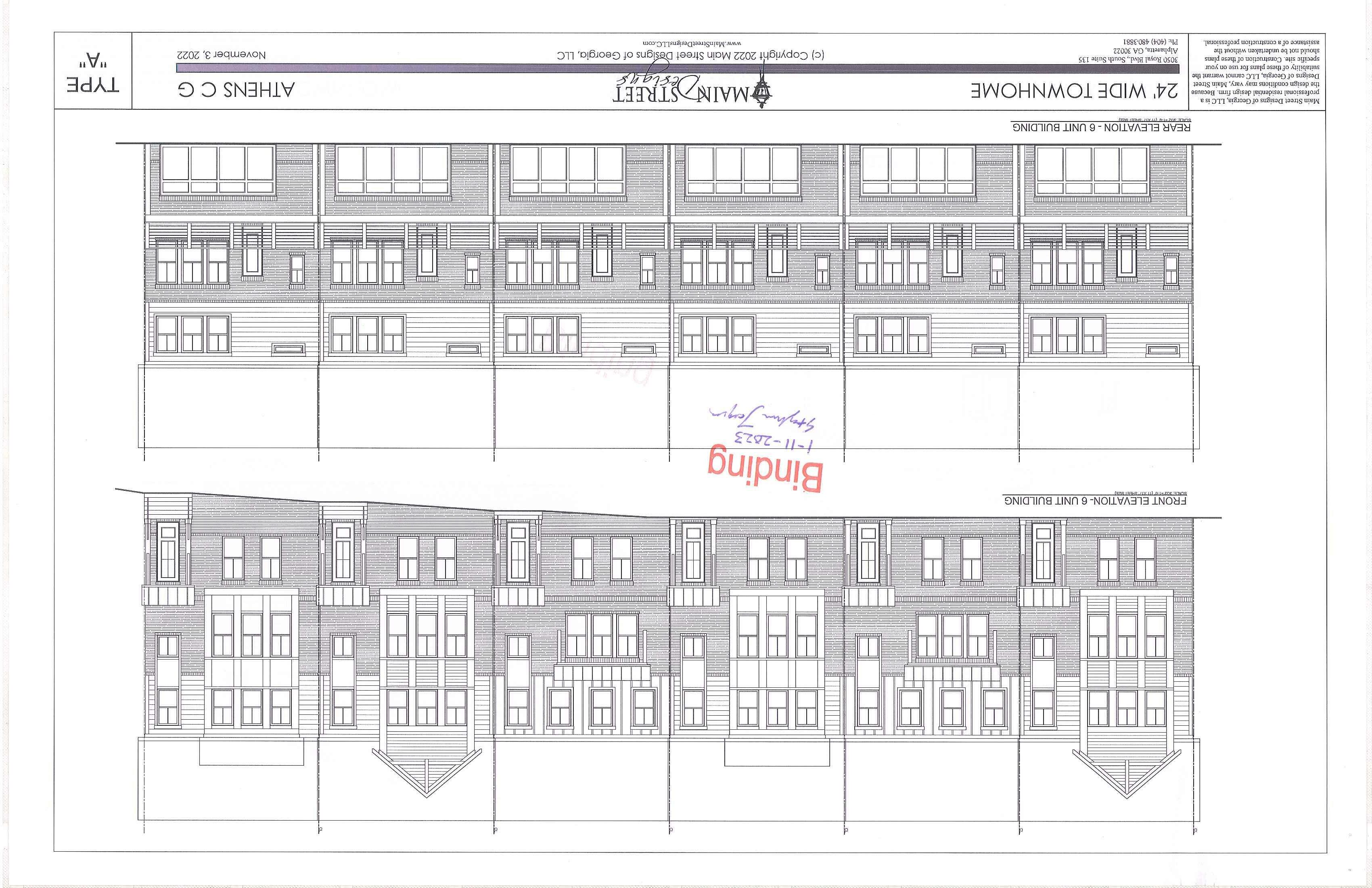
2. The townhomes do not use enough design features to comply with Section 9-25-8(B)l.
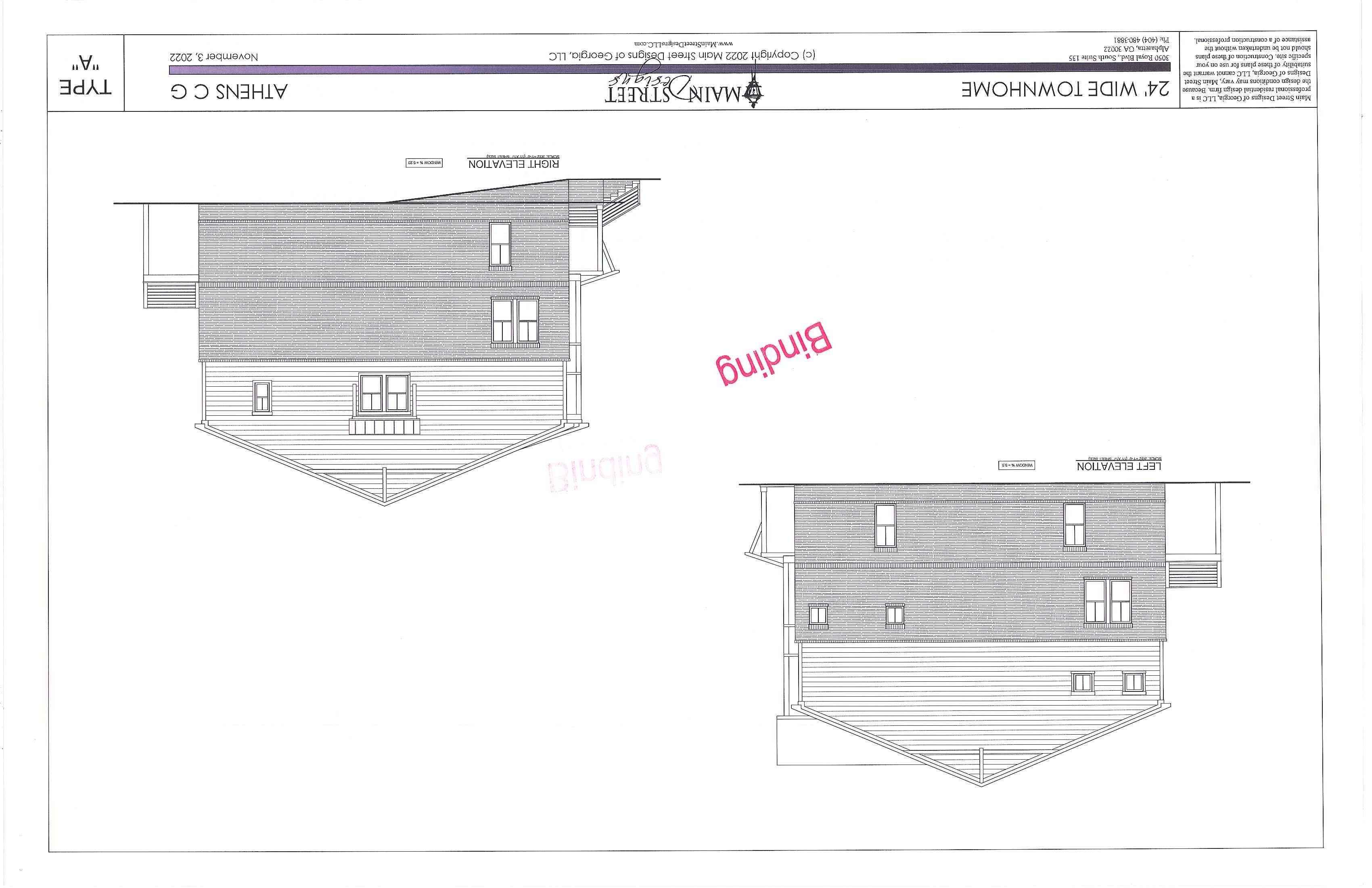
3. The townhomes do not have enough side fenestration to comply with Section 9- 25-8(B)4.
4. Multiple blocks exceed the 3-acre maximum in Section 9-25-8(C)3.
5 No children's play area was designated as required in Section 9-25-8(C)7 c.
6. The plan does not comply with the plaza coverage and design requirements of Section 9-25-8(F)2.
7. The site plan does not match the elevations shown for the mixed-use buildings nor the senior housing. The fa<;ade offsets shown on the elevations are not shown in the site plan , and the building shapes on the site plan are not reflected in the elevations. The elevations on some of the buildings do not match from one cardinal direction view to the next.
8. Applicant showed retaining walls but did not specify which ones would be greater than four feet high.
The applicant has provided a plan clearly identifying the thre e proposed phases of development. However, an individual site plan needs to be provided for each phase with notes for each plan indicating ongoing compliance for maximum residential density , maximum lot coverage, maximum floor area ratio, minimum and maximum parking calculations , etc.
EFFECT ON COMMUNITY
I. BALANCE OF LAND USES IN ATHENS-CLARKE COUNTY
The mall building is cwTently 791 ,011 sq. ft . per tax records, with an additional empty theater and two outparcels. Hundreds of thousands of square feet of commercial space will be demolished to make way for townhouses and mixed-use apartment buildings with new retail. The remaining mall structure will add office uses to its existing retail. The current balance of land uses is overweighted on commercial , as evidenced by the numerous vacancies. The proposal brings much needed balance through its office and residential uses. The redevelopment of this site has the opportunity to create a balanced neighborhood where people can live and meet a variety of daily needs instead of trying to be a regional magnet for commerce. When it was built, the mall dramatically shifted the balance of land uses away from Downtown and the traditional urban core of Athens A well-designed redevelopment of this site could once again shift the balance of land uses by creating a Westside "downtown" where residents would be attracted to gather,
12
recreate , and do busine ss . This could also ad d e ner gy to adjacent properties and neighb o rhood s that hav e felt th e negative impact of th e mall 's decline
The sca le of the d evelopment triggered a Deve lopment of Regional Imp ac t (DRT) Review by the Northeast Georgia Regional C ommission , the resu lt s of which are attached to thi s report (Note: the NEGRC revi ewed a prev ious ite rati o n of thi s plan and did not provide input on the current proposal since the changes did n ot wanant another round of review).
II. POPULATION
Based on the b ed room count, the ove ra ll population would increase up to 2, 057 , d epending on the occupan cy of the uni ts with multipl e bedrooms. The proposal includes a total of 1, 188 resid ential units, includin g 11 2 studio units , 526 one- bed room units, 292 two-bedro o m units, 56 three-b edroom tmits, and 202 townhome s in 2 -4 bedroom tloorplan s. Importantly , for a community with smaller average house hold sizes , 3 1% of the bedrooms and 54 % o f the units are in studio/ one-bedroom formats.
III. ENVIRONMENT
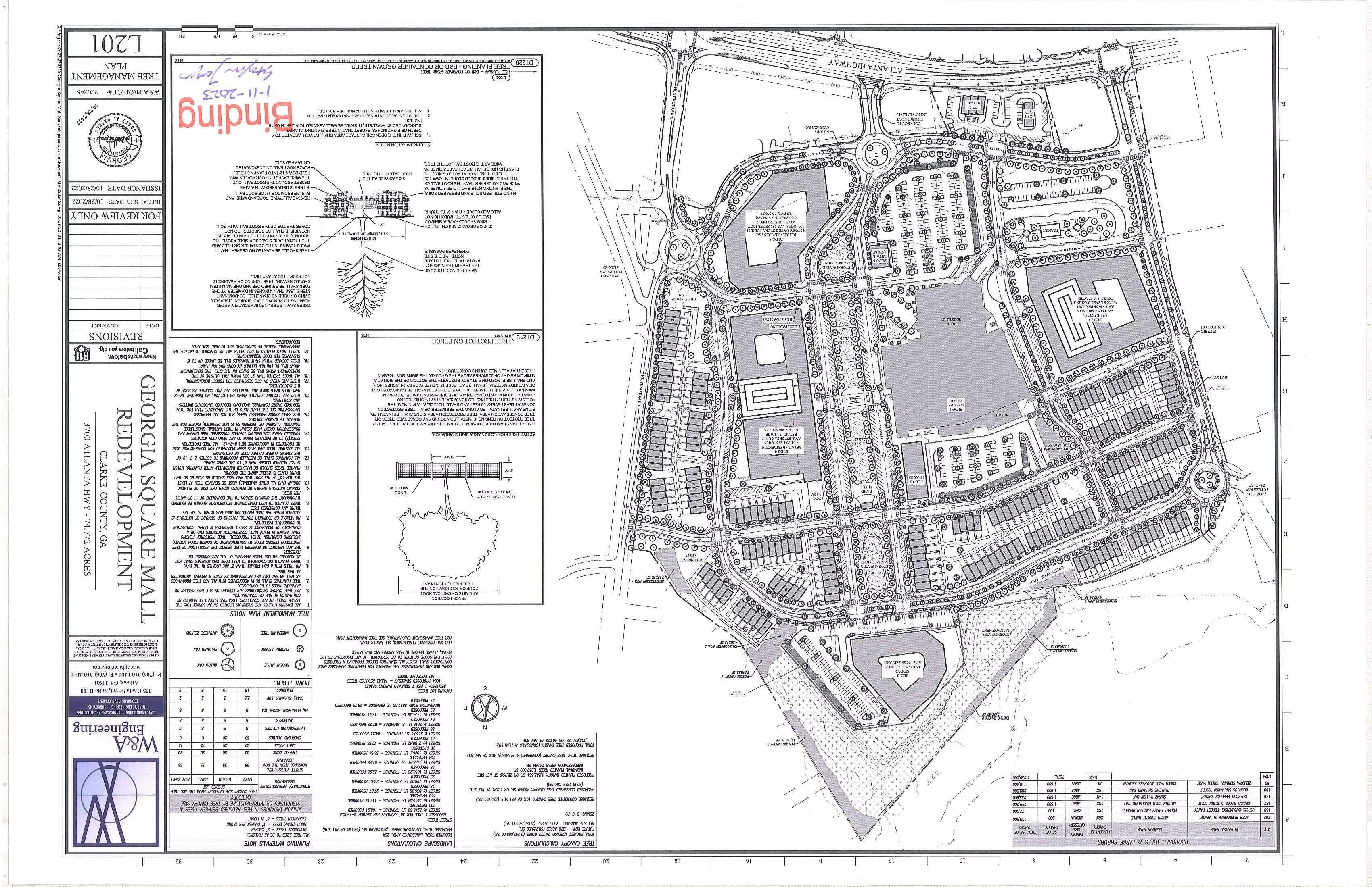
The · Co unty (ACC) Environmenta l Areas t\:iap indicates the presence of a pro te cted environmental a rea on site. Specifically, the northwestern portion of the subject property has a 75 ' riparian buffer in th e area of the propo se d stormwate r retention pond.
Th e ACC Arborist ha s reviewe d and approved the p lan without comment.
IV. TRAFFIC, TRANSPORTATION, & TRANSIT
The Traffic Impact Analysis provided with the preliminary plan has been r evised and resubmitted with the master application materials for continued Staff rev iew. This section of Atlanta Highw ay is schedu led for construction as part of the Georgia Departm ent of Transportation's (GDOT) project to rebuild the Loop 10 interchange with Atlanta Highway.
As noted above, the s ite has been divided into blocks with new streets including multi-use path s and sidewalks By Staff's count, 6 of the 12 blocks exceed the 3-acre block maximum imposed by Section 925-8(C)3. Not only do es this plan violate the Code, it mi sses an opportunity to create a dense transportation network that is scaled for walking instead of driving. This 75 -acre s ite is close to t he size of Ath ens' 90acre downtown, and could se rve a s a " downtown " for the west side of Athens. Downtown has a smaller synunetrical block network that is ideall y scaled for wa lking compared with the propo sed block network for the Mall. The blocks that break the 3-acre maximum create circui tous routes for pedestrians and decrease the amount of potential interest-gene ratin g block frontage. Having a tran s portation network with fr eq uent connections also would allow traffic to flow more smoothly because there are more route choices.
Staff note s that many of the streets hav e vehicl e travel lanes of 12 feet that are more appropriate for highways than local surface s treets. Th is site is positioned to be a neighborhood destination with s ignificant foot traffic. Therefore, design elements like narrow travel lanes should be used to prioriti ze safety and accessibili ty. Given the increased den s ity proposed for the site , the applicant may want to consider swapping some ofthe on-street parking for des ignated delivery/loading zones to ensure efficient transfer of goods .
The ACC Transportation and Publ ic W orks Department has reviewed the app lication and h as the foll owin g transportation-related comments:
13
• The proposed localion of the Huntin gton Rd r o undabout creates a potential haz ard due to the location ofth e exis ting ATM driveway in th e northbound Huntingto n Rd exit lane, very close to th e circle itse?f" Eith er the roundabout or th e driveway needs Lo he shijied to achieve more separation or perhaps bring the driveway directly in to th e roundabout.
• The binding plan to note that the Marilyn ·Farmer Way roundabout and the Huntington Road rounda bout paveme nt s will meet ACC paving standards for a major collector.
• Please include a TJA including the intersection ofAtlanta Highway at Cleveland Road. The TJA must include remedies for any drop in LOS ofthe affected intersections.
Athens Transit currently services two bus route s, Route 20 and Route 21, through the subjec t property, and two ACC Transit bus stops are currently located on t he property. The ACC Transit Department has revi e wed and approved the proposal without comment.
V. GRADING AND DRAINAGE
The ACC Transportation and Public Works Department has reviewed the application and has no gradingor drainage-related comments at this time.
VI. WATER AND SEWER AVAILABILITY
The ACC Public Utilities Department has reviewed thi s request and recommended ap proval with the following comments:
• All .fee simple townhouse lots require independent water and sewer services.
VII. FIRE PROTECTION
The ACC Fire Marshal has reviewed and approved this request without comment.
RECOMMENDATIONS
I. STAFF RECOMMENDATION
Future Land Use- Approval Zoning- Approval with Conditions
The purpose of the planned deve lopment request is to redevelop the Georgia Square Mall property for the purpose of a mixed-use residential, commercial, and office development. The reque st is compatible with the existing General Business Future Land Use designation and the Commercial-General zoning of the prope1ty.
It is important to get the de sign right on this site beca u se of its generational impact on Athens. The proposal trades commercial space and parking for a grid-like street network, residential u ses , multi-modal connectivity , and greenspace, as recommended previously b y the Planning Commission. Staff supports the addition of a ll of these elements as well. The proposal has been improved compared to its original form. However, Staff has found missed opportunities to create an attractive, resilient urban neighborhood out of this declinin g s uburban mall. The basic components of a neighborhood are present, but Staff recommends approval with the following conditions in an effort to align the proposal with the full potential of the site : 1. The applicant must amend the plan to correct the following code compliance issues: a. The applicant does not show that the apartments are complying with the 450 ' minimum square footage requirement of Section 9-15-15.
14
II.
b . The townhomes do not use enough design features to comply with Section 9-25-S(B) 1.
c. The townhomes do not have enough side fenestration to comply with Section 9-25 - 8(B)4.
d. No children's play area was designated as required in Section 9-25 - 8(C)7.c.
e The plan does not comply with the plaza coverage and design requirements of Section 9- 258(F)2 .
f. The site plan does not match the elevations shown for the mixed-use buildings nor the senior housing. The fa9ade offsets shown on the elevations are not shown in the site plan, and the building shapes on the site plan are not reflected in the elevations. The elevations on some of the buildings do not match from one cardinal direction view to the next.
g. Applicant showed retaining walls but did not specify which ones would be greater than four feet high. -
2. The applicant shall request a waiver for exceeding the 3-acre block maximum of Section 9-25-8(C)3.
3. The architecture can be amended administratively with Staff review and approval.
4. Public dedication of the north/south street running along the western edge of the property between Marilyn Farmer Way and Atlanta Hwy and at least one of the east/west streets connecting Huntington Rd with this north/south street can be considered without amending the planned development.
5 . The applicant must provide a publicly accessible bike and pedestrian connection between the center green and the parallel street running between Building 4 and the townhomes.
6 . Building 3 shall be modified to provide direct pedestrian connection from the building to the street by removing the parking strip.
7. Phase 2, as shown, on the Redevelopment Concept Plan, dated 10- 19-22, shall be approved with the density proposed in this application, but should be afforded an opportunity to be redesigned to reduce building scale and incorporate a wider variety of "Missing Middle" housing types with Staff approval.
8. Greens (including the dual purpose stormwater greens) shall be designed to incorporate public art and other programmed design elements to encourage pedestrian use of these spaces.
9. The submittal shall be amended to comply with the following Public Works requirements:
a. The proposed location of the Huntington Rd roundabout creates a potential hazard due to the location of the existing ATM driveway in the northbound Huntington Rd exit lane , very close to the circle itself. Either the roundabout or the driveway needs to be shifted to achieve more separation or perhaps bring the driveway directly in to the roundabout.
b. The binding plan needs to note that the Marilyn Farmer Way roundabout and the Huntington Road roundabout pavements will meet ACC paving standards for a major collector.
c Include a TIA including the intersection of Atlanta Highway at Cleveland Road. The TIA must include remedies for any drop in LOS of the affected intersections.
PLANNI NG COMMISSION RECOMMENDATIONS
Future Land Use- Approval
Zoning - Approval with Conditions
The Planning Commission considered the requests at their regular meeting on December 8, 2022 and voted to approve the requests with the conditions as stated in this staff report.
Ill. CURRENT STATUS
The request and the Planning Commission recommendation are tentatively scheduled for presentation to the Mayor and Commission at their agenda setting on January 17, 2023 . The applicant revised their report to request the waiver in Condition 2 Therefore, Condition 2 is not in effect. The Mayor and Commission are tentatively scheduled to take action on this request on February 7, 2023.
15
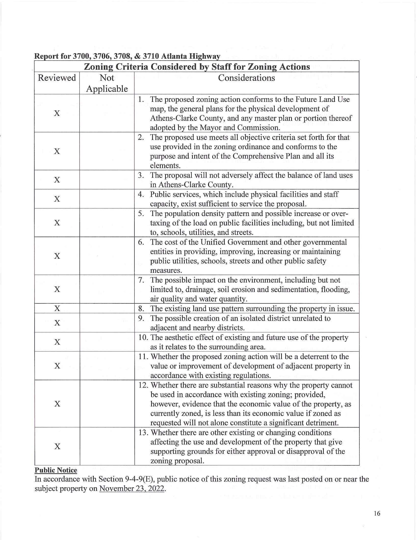
Zoning Criteria Considered by Staff for Zoning Actions
Reviewed Not Considerations
Applicable
1. The proposed zoning action conforms to the Future Land Use
map, the general plans for the physical development of Athens-Clarke County, and any master plan or portion thereof adopted by the Mayor and Commission
2. The proposed use meets all objective criteria set forth for that
use provided in the zoning ordinance and conforms to the purpose and intent of the Comprehensive Plan and all its elements.
3. The proposal will not adversely affect the balance of land uses in Athens-Clarke County.
4. Public services, which include physical facilities and staff capacity_, exist sufficient to service the proposal.
5 T he population density pattern and possible increase or over-
taxing of the load on public facilities including, but not limited to , schools, utilities, and streets.
6. The cost of the Unified Government and other governmental
entities in providing, improving , increasing or maintaining public utilities, schools, streets and other publ i c safety measures.
7. The possible impact on the environment, including but not
limited to, drainage, soil erosion and sedimentation, flooding, air quality and water quantity.
8. The existing land use pattern surrounding the property in issue.
9 . The possible creation of an isolated district unrelated to adjacent and nearby districts
10. The aesthetic effect of existing and future use of the property as it relates to the surrounding area
11 Whether the proposed zoning action will be a deterrent to the
value or improvement of development of adjacent property in accordance with existing regulations.
12. Whether there are substantial reasons why the property cannot be used in accordance with existing zoning; provided ,
however , evidence that the economic value of the property, as currently zoned, is less than its economic value if zoned as requested will not alone constitute a significant detriment.
13. Whether there are other existing or changing conditions
affecting the use and development of the property that give supporting grounds for either approval or disapproval of the zoning proposal.
Public Notice
In accordance with Section 9-4-9(E), public notice of this zoning request was last posted on or near the subject property on November 23, 2022.
R t 3700 3706 3708 & 3710 A I t H" h epor o r ' ' ' tan a Igl way
X
X
X
X
X
X
X
X
X
X
X
X
X
16
NEGRC
N ORT H EAST GEO RGIA REG I ONAL COM MI SS I ON
DEVELOPMENTS OF REGIONAL IMPACT
Final Report
Northeast Georg ia Reg io na l Co mmiss io n • 30 5 Resea rch Dri ve, Athen s, Geo rg ia • www negrc. org
The Northeast Georgia Regional Commission (NEGRC) has completed its review of the following Development of Regional Impact (DRI). This repor t contains the NEGRC' s assessment of h ow the proposed project relates to the policies, prog rams, and projects articula ted in the Regio n a l Plan and Regional Re so urce Plan. A lso included is an assessment of like ly interjurisdictiona l impacts resultin g from the proposed d evelopment, as well as all comments rece ived from identified affected parties and others during the fifteenday comment period.
The materials presented in this report are purely advisory and under no circumstances should be co n side red as binding or infringin g upon the host jurisdiction's ri g ht to determine for i tself the appropriate n ess of d evel op m e nt within its boundaries.
Transmittal of this DRI r epo rt officially comp letes the DRI process . The s ubmittin g loca l government may proceed w ith whatever final officia l actions it deems appropriate regardin g the proposed project, but it is encourage d to take the materia ls prese nted in th e DRI report into consideration whe n rendering its d ecis ion.
Project I. D.:
Name of Project:
Name of Host Jurisdiction:
Background
DRI #3563
Georgia Square Mall Redevelopment Athens-Clarke Co unty
DRI review was initi a t ed foll owing the developer's request for a re zon in g with variances from Ath ens-Clarke County initiated the review. The property wo uld be rezoned from Commercial-General (C-G) to CommercialGene ral Planned Development (C-G PO ). Pote ntiall y affected parties were aske d t o submi t commen t s o n th e proposal during the 15-day period of 01/20/22-02/04/22.
Proposed Development
Mark Jennings i s proposing rede ve lopment of the ex is ting Georgia Square Mall into a mi xed-use d evelo pme n t, including 986 multi-famil y units, 152 se nio r li v ing units, 63,500 SF of retail, 28,500 SF of restau rant space, and re-use of 293,000 SF of existing commercial s p ace on a 75-acre site (parce l numbers: 073 016, 073 01 6F, 073 016J, 073 016K, 073 016S, and 073 016T) at 3700 Atlanta Hwy in Athens-Clarke Co unty. Additionally, one detention pond and 2,937 parking spaces wo uld be constru cted. According t o the site plan, the project would be co mpleted in eight pha ses with an es timated co mple tion date in 2026 Phase One wou ld include 136 housing units and demolition/renovation of the exi sting mall structure. Phase T wo wou l d include 52 h ousing uni ts and 17,000 SF of retail/restaurant. Phase Three wo uld include 216 housing uni ts Phase Four wo uld include 248 hou s ing units. Phase Five w ould include 80 h ousing units. Phase Six wo uld include 76 housing units Phase Seven wou ld include 34,000 SF of re ta il/ resta ura nt. Finally, Phase Eight wou ld include 41,000 SF of grocery/retail/restaurant s pace C urr en tly, the site is a nearly d e fun ct mall. Part of the ex isting str u cture would be d e molis h e d and re pl ace d w ith parking lots.
DRI #3563 Final Report 1
Compatibility with Existing Plans
The site is identified as "General Business" and "Employment Center" on the Athens-Clarke County Comprehensive Plan' s Future Land Use Map (dated 06/13/2018) . It is also categorized as "Retail Sales/Personal Services" on the Land Based Classification Standards Map in the Plan. The "General Business" us e includes: "Commercial areas that se r ve a variety of needs for the r esidents of the reg ion. It is intende d for small- and l arge-scale retailing a nd se rvice u ses that are auto-oriented, such as Atlanta Highway. Pedestrian-oriented d esign is particularly a ppropriate when these streets contain neighborhood-shopping areas or are adjacent to multifamily housing or r esidential neighborhoods Pedestrian circulation in these centers is a primary conc e rn, therefore, connectiv ity within and to surrounding areas should b e e ncouraged."
The area description also s tates that stree t -level facades should have a pedestrian scale and architecture, with buildings that are orie nte d towards tree-line d s treets. Small and m e dium scale retail s tores s hould frame the streets and ped estrian circulation should b e prioritized over automobile access. Parking lots should not be located at the street front and shared p a rking should b e e n co uraged. The Plan encourages infill hous ing in areas near comme rcial nodes.
The Plan describes th e "Employment Center" category as "areas of industry, office, research parks, and fle xs pace mixed u ses." Housing is conside r e d incompatible with the u ses proposed for this area.

Aside from heavy indu s try, there appears to be conside rable room to compatibly mix uses like offices with h o using on this site. However, the propos al doe s not appear to meet the recomme ndations for the Plan's "Gen eral Business" category. The propo sal makes little e ffort to create an e nvironme nt that is safe, comfort able, u se ful, and afu·active for pedestrians, and it includes no connections to the adjacent n e i ghborhoods tha t would assumedly serve as a critical sour ce of business for co mmercial ten a nts. Rather than b e in g built at a pedestrian scale, mo st of the proposed structures are scaled to fill an entire block without creating an inte r esting or inviting streetscap e for p e d estrian s. Furthe rmor e, the fo ur-l ane ring road would retain its existing configuration around most of the site - serving as a moat separating the prope rty from co nnec tivity to th e adjacent community. The vast amount of s urface p ar kin g that is proje cte d for the site e n sures th at the design will continue t o be au to-orie nted, at the ex pense of pedes trians and place -making. Th e s ite is identified as "Developing" on th e No rtheas t Georgia Regional Pla n 's Regional Land Use Map (date d 6/7/2018). It is also lis t e d as an area with potential for redevelopment according to the Areas Requiring Special Attention Map in the Plan. Gre yfield re de ve lopment is encouraged t o create more n e ighbo r ho o d and pedestrian friendl y places, housing ch oices, a sense of place, and multiple trans portation options. Th e Regional P lan recommends d eve lopment that matches the region's wo rkforce, prices in the lifecycle cost of infrastructure, creates a sense of place, build s a compact development patte rn on exis ting infras tru c ture, creates div e rs e and affordable housin g, and complime nts exis ting and planne d tran s portation optionsespecially non -automobile transportation modes.
The site plan shows limite d attempts to create a pedestria n and n e ighborhoo d friendly design. Only the s m a ll restaurant area in Phase VII makes any a tte mpt to create an a ttractive gathering place for people; ove rall, the s ite layout seems t o create isolated pods of buildings that are s urrounded b y ext e n sive a reas of pavement and landscaped media n s. The project would provide two types of hou s ing: large multi-famil y s tru ctures and "active a dult" units. However, the proposal fa ils to connect them to each other and rest of the d eve lopme nt throug h any kind of meaningful multi-modal access. The plan actually proposes re ducin g the numb er of bike parking s paces r equir e d by l ocal regulations. It is important to acknowl e dge this site has long - a waited
DRI
Final Report 2
#3563
redevelopment and the project would likely increase the tax value of the site. However, a "suburban-retrofit" style development would likely increase the project's va lue significantly while also better aligning it w ith the local and regional plans. It could become a kind of "downtown" for the west side of Athens where people l ove to gather and public events are held. In order to meet the recommendations of local and regional plans and s uburb an retrofit best practices, proposals for this site s hould convert the ex is tin g rin g road from four lane s to two lanes with a protected two-way bicycle lane and parallel parking. Bike and pedestrian connections sho uld be made to adjacent s treets, like Cavalier Road, Ch e rokee Ridge, and Meeler Circle, as well as to properties like Akademia Brewing and the Meadowland apartment complex. An internal street network, with wide shady sidewalks and easy bike access, should also b e established. The Avalon project, in Alpharetta, provides a ne arby example of how to create an attractive main stree t for a project like this. It's also recommended the project be divided into walkable blocks that are populated with buildings that engage people through frequent doors and windows along the sidewalk. Shallow "liner" buildings can be used to frame these sh·eets and provide the feel of an attractive "urban village." These commercial spaces are especially attractive to local businesses. The proposal should provide a variety of housing at different price points. These kinds of sites can add many of the "Missing Middle Housing" types like townhomes, live/work units, quadplexes, and 10-20 unit multi-plexes. One of the primary obstacles to this kind of redevelopment is excessive parking. Too much parking lead s to excessive s tormwater runoff, crowds out value-producing buildings, and encourages automobile dependency. Although the site is curren tly characterized by an over-abundance of parking, existing parking requirements would mandate add itional parking if the proposal moved forward The total amount of parking should be significantly reduced and s tacked, on-street, or shared parking s hould be used to r educe the amount of surface space devoted to parking. Parking decks s hould be shielded from the street where possible. If the entire site cannot be developed at the onset, then streets, utilities, and parking lots can be laid out in a way that allows for infill development, as it becomes feasible. This style of creative redesign may be necessary to successfully extend the site's longevity for a significant period of time. As currently designed, the project appears to only align with th e Regional Plan's desire for infill development and the creation of affordab le housing options.
Potential lnterjurisdictional Impacts
The applicant states that the project is unlike ly to affect any of the environmental quality factors identified on the DRI Additional Form, including water s upply watersheds, groundwater recharge areas, we tlands, protected mountain and river corridors, floodplains, historic resources, and other environmentally sensitive resources. An estimated 72-73% of the site would be covered in imper vious surfaces, and o n e large retention pond is planned to manage stormwater runoff. The site is almost completely covered in impervious s urfac es in its c urrent state. The applicant states that stormwa te r facilities, d es igned in accordance with the Georgia Stormwater Management Manual and Athens-Clarke County regulations, would be provided. Since the site i s almost comple te ly covered in impervious surfaces, any reduction would be an impro vement for the management of s t ormwater. Significantly reducing the amount of surface parking is recommended to minimize s tormwater runoff. Furthermore, the planned retention pond misses an opportunity to become an amenity for the s ite, as was done in Atlanta's Old Fourth Ward Park. The de veloper should consider managing stormwate r through multiple dual-pu rpo se retention and amenity pond s that could serve as attractive va lueadding anchors for multiple sections o f the site. Low-impact design measures, like bioswales, rain garden s, green roofs, p ermeable paving, and other green infrastructure should be incorporated into the project design. At minimum, the project should be in acco rdan ce with the latest edition of the Georgia S torm water Management Manual (Blue Book) and meet all relevant EPD requirements.
Th e Na tion al Wetland Inventory (NWI) id e ntifies zero acres of wetlands onsite and 90 acres of wetlands within one mile of the site. The Northeast Georgia Regional Plan's Conservation and Development Map (dated
DRI #3563 Final Report 3
7/19/2018) identifies zero acres of "Conservation" land onsite and 351 acres of "Conservation" land within one mile of the site. This "Conservation" land includes 247 acres of Regionally Important Resource land within one mile of the site. No specific Regionally Important Resource sites are identified within one mile of the proposed site.
Kimley-Horn has performed a traffic study for the proposal that estimates the project would generate 8,462 daily trips, including 601 AM Peak Hour trips and 582 PM Peak Hour Trips. The study concludes that the adjacent roadway network is sufficient to handle these trips, although this is based on including the Georgia Dept. of Transportation's future 2023 reconstruction of the nearby interchange between Atlanta Hwy and the Athens Loop, and the associated widening of Atlanta Hwy to eight lanes into its calculations. No new infrastmcture is proposed for the site beyond the five existing entrances. However, as stated above, significant improvements are recommended by the NEGRC to improve bike and pedestrian accessibility. More importantly, the redevelopment of this site could generate significant ridership for Athens-Clarke County's transit service. The site already has a bus stop, but the redevelopment application makes no mention of turning this site into a transit-friendly hub. Particularly with residential units targeted toward older populations, this project should not miss the opportunity to incorporate transit-friendly design elements.
The project would be served by the Athens-Clarke County water and sewer systems with an estimated daily demand of 0.31 MGD for water and 0.28 MGD for wastewater service. The applicant states that these demands can be covered by existing capacity. No water or sewer line extensions are anticipated. The applicant estimates the project would generate 5,857 tons of solid waste annually and that sufficient landfill capacity exists to handle this waste. No hazardous waste would be generated .
The applicant estimates that the project would be worth $426 million at build-out, in 2026, and generate $10 million in annual local taxes. On a per-acre basis, the project would be worth approximately $5.7 million and generate approximately $133,000 in tax revenue. Prior to approval, the Unified Government should measure the life cycle costs of the infrastructure needed to serve this project to ensure that they would not be committing to more maintenance expenses than the new tax revenue can cover. As stated above, the project would likely raise the value of the site, but a quality suburban retrofit project would likely provide even more tax value by minimizing negative space in favor of value-producing buildings and amenities.
Comments from Affected Parties
Alan
Hood, Airport Safety Data Program Manager, Georgia Department of Transportation
This proposed project is 7.3 miles west of the Athens-Ben Epps Airport (AHN), and is located outside of any FAA approach or departure surfaces, and airport compatible land use areas, and does not appear to impact the airport. However, if any construction or construction equipment reaches 200' AGL or more, an FAA Form 7460-1 must be submitted to the Federal Aviation Administration. That may be done online at https ://oeaaa.faa .gov. The FAA must be in receipt of the notification, no later than 120 days prior to construction. The FAA will evaluate the potential impact of the project on protected airspace associated with the airports and advise the proponent if any action is necessary. Thank you for the opportunity to comment on the proposed development.
DRI #3563 Final Report 4
·::: ;









December 12, 2022
Stephe n Jaques - Planne r II
Athens-Clarke Cou nty Pl anning De p artm ent 120 W. Doughert y Street Athen s, GA 306 01
ENGINEERING
f-rz-vi'V'- /;v, a-. r ./ "'•
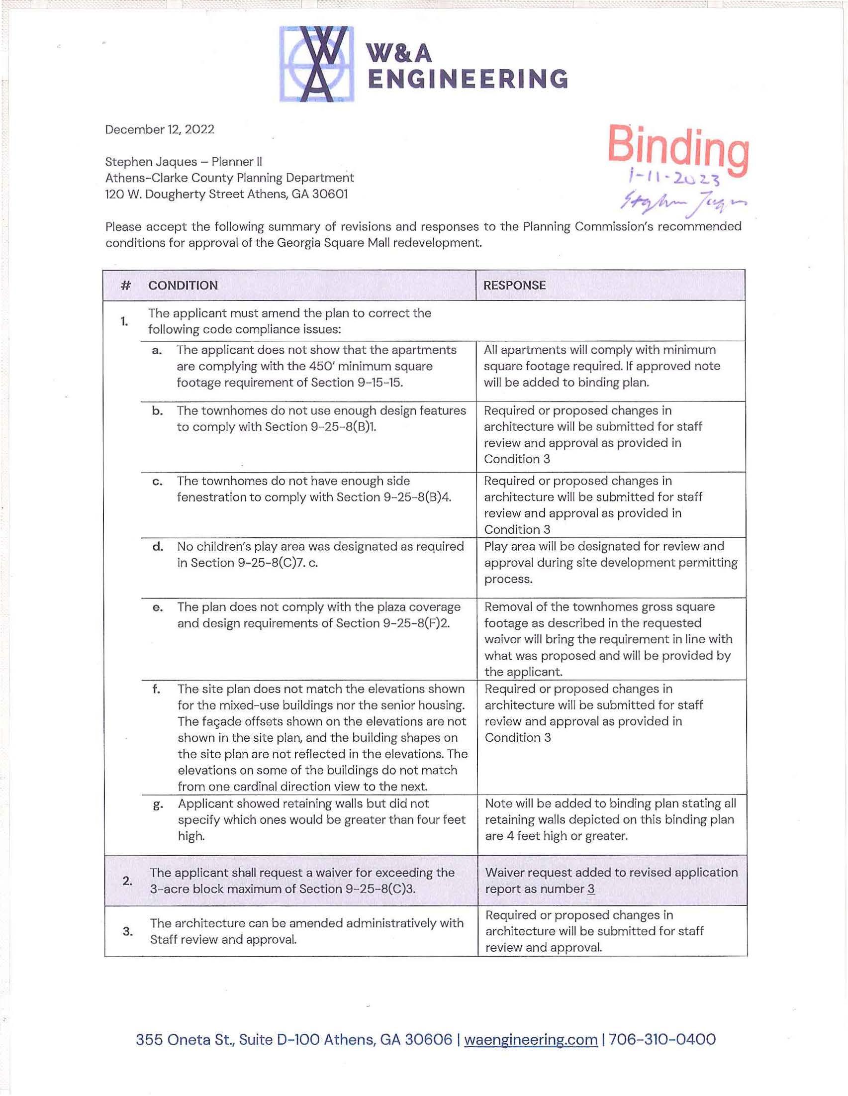
Please accept the followin g su mm ary o f revis i ons an d res ponses to the Planning Commission's recomme n ded co nditions for approval of the Geo rg ia Sq u are Mall red eve lopment.
# CONDITION RESPONSE
1. The app li ca nt must amend the plan to corr ect the followi n g co de compl iance issues:
a The applicant d oes not show that the apartments All apartments w i ll comply with minimum ar e complying with the 450' minimum square square foo tage requ i red. If approved note footage requi re ment o f Section 9-15-15. will be added to b i nding plan.
b. Th e townhomes do not use enoug h d esign features Requ i red or p r oposed changes i n to comply with Sect ion 9-25-8( 8)1. architect ure w i ll be submitted fo r staff review and approva l as pr ovided in Cond itio n 3
c. The townhomes do not hav e enough sid e Required or proposed changes in fenes tratio n to co mply wi t h Section 9 - 25 - 8(8)4. architec t ure w ill be subm itted f or staff review and app rova l as p rovided in Condi t i on 3
d. No ch il dren's play area was designated as required Pl ay area w ill be des ignated for r eview and in Section 9 - 25 - 8(C)7. c. approval during site development perm itting process
e. The plan does not comply with the pl aza cover age Removal o f the to wn homes gross square and design requirements of Secti on 9-25-8(F)2. footage as described in the requested waiver will bring the re q uir emen t in lin e with what was proposed and will be provided by the applicant
f. The s ite plan does n ot match the elevatio ns show n Req ui re d or proposed changes in for the mixed-use bui l dings n or the senior hou si n g. arc hitecture wi ll be submit ted for staff The f ar;;ade offsets shown on t he e levations are not review and approva l as provided in show n in the site plan, and the buildin g sha pes on Cond ition 3 t h e sit e plan are not r efl ect ed in th e el ev at i on s. T h e e levati o n s on so me o f the bui ld i n gs do n ot match f r om one ca rd i n al d i rectio n v i ew to t h e n ext.
g App li ca nt showed retai n ing walls but d id not
Note wil l b e added to bindi n g p lan stating all spec ify which ones wou ld be gr eater t han fou r f eet re t aining wall s depict ed on t his b i nding plan high. are 4 feet hi gh or greater.
2. The applica nt s hall r eq u est a waiver for exceed ing t h e Waiver req u est added to revised application 3 - acr e block maxi mum of Section 9 -25-8(C)3. rep ort as number Q
Required or proposed ch anges i n
The arc hitectu re can be amended administr at iv ely with
3. architectu re will be submitted for sta f f Staff r eview and approval. review and approval.
W&A
355 O neta St ., Sui te D- 100 At h en s, GA 30606 I w ae n gin ee r in g.c o m I 706-3 10 - 04 00
CONDITION
Publi c d ed i ca ti on of th e n orth/sout h str eet running along the we stern edge of the prop ert y b etween Marilyn
4. Farmer Way and Atlanta Hwy and at lea st o ne of the
RESPONSE
Appli c ant agree s to t h is c ondition. east- w est streets conn ecting Huntington Rd with thi s north/sou t h street can b e co n sider ed w ith out am ending the pl anned d evelopme nt
The ap p li ca nt m ust prov ide a publi c ly access ib l e bi ke
Appli cant s agree to th i s cond it ion and wi l l provi de a bicycle an d ped estr ian connec t io n 5 and ped estr i an connecti o n b etween t he cent er gre en between the cent er gre en and the p ar all el and t he paralle l street r u nn ing b et ween Bui l d in g 4 and the townhomes street running bet ween Bu il ding 4 and the tow nhomes
Building 3 shall be mod if ied to provid e di rect pedest rian Binding p la n s will show m o di fi ed loc ation for 6 connec t ion from the build ing to the street by removing Building 3 and pedestrian connec t i on the park ing strip betwe en building an d street.
Ph as e 2, as sh o wn, on the Redevel opmen t Conc ept Plan, d a ted 10-1 9 - 2 2, sh all be ap prove d w it h t h e d ensity Re qu ired or proposed c h an ges i n
7. pr op osed in t his app l icati on, but sh oul d be affo rded an ar c hite cture w i ll b e su bmitte d for sta ff opportunity to be red es ig ned to redu ce building sc al e revi ew an d ap p roval as pro vi de d in an d i n corpo rate a w ide r varie t y of " M issi n g Mi d d l e" Co n d it i on 3 hou si ng types w ith Staff approval.
Green s (incl u ding t h e d u al-purp ose st ormw ater greens )
8. shall b e des igned to in c orporate publi c art and other
App lic an t agrees to t his c onditi on p rogram med d esign el em ents to en c ourage pedestrian u se o f these spa ces.
9. The subm ittal s hall be amend ed to comply with th e following Public Works requ i rements:

a. The proposed location of the Huntington Rd Applicant will pro v ide solution t o address roun da bout creat es a potential h azard due to th e t he pot ent ia l ha zard wi ll be rev iewed and location of the ex isting ATM driveway in t he appro v ed b y TP W as part of the s ite northbound Huntington Rd ex it lane, v ery close t o deve lopme nt pe rmi tti ng p roce ss. the c ircl e itself Either th e roundabout or the driveway needs t o b e shifted to achi eve more separation or perhaps bring the driveway directly in t o th e roundabout.
b. The b i nding plan needs t o not e tha t the Marilyn Note w ill b e added t o bind i ng plan th at th e Farm er Way roundabout and the Huntington Road Marilyn Farm er Way roundab out and t h e roundabout paveme nts will m eet AC C paving Huntingto n Road round ab out pavement s wi ll sta ndard s for a maj o r c ollector meet ACC pa vi ng standard s fo r a major c o llector
c. Includ e a TIA includ ing the intersection of Atlanta Updat ed TIA w hi c h include s t he r equested Highway at Cleveland Road. The TIA must include additiona l int erse cti o n wi th remedi es for any drop in LOS of the affected recommendations fo r any drop in LOS of intersections affect ed inte rsect ions w i ll be subm itted f o r r eview and ap p rov al as part o f t he site dev el opment permitting pro ces s.
Binding #
I. Request Overview
Applicant: Location: Tax Parcels: Size: Current Use: C u r rent Zoning: Proposed Zoning: Current FLU: Proposed FLU :
W&A ENGINEERING
Georgia Square Mall Redevelopment 12/12/2022 - #220246
Master Planned Development Application Report W&A Engineering, Georg ia
W&A Engineer in g, Georgia 3700, 3706, 3708, 3710 Atlanta Highway 073 016; 073 016F; 073 016J; 073 016K; 073 016S; 073 016T 74.77 acres Georgia Square Mall C-G C-G (PD) Employment and General Business General Business
The purpose of this request is to rezone six (6) parcels currently zoned C-G (Commercial General) to C-G (PD) (Commercial General, Planned Deve lopmen t) to construct a mixed-use commercial and residential development on a 74.77-acre site. Due to several requested waivers of required standards, a planned development is being requested. An amendment to Future Land Use Map for one existing tax parcel. the property located at the northern boundary (3710 At la nta Highway), to change the current designation from Employment Center to Genera l Business is also being requested. The remaining five subject parcels are currently designated as General Business
II. Site Description
The subject parcels are the site o f the Georgia Square Mal l, two associated outparcels along Atlanta Highway, and the former movie theatre to the rear of the mall. The Georgia Square Mall has been in operation since the 1980's for commercial use. The two outparcels along At la nta Hig hway (3706 and 3708) were constructed around the same time as the mall, and the existing comme rcial buildings have been occupied by various tenants for commercial uses. The northernmost parcel at 3710 Atlanta Highway contains a structure, built in 1984, which was used as a multi-screen movie theatre. The subj ect property fronts Atlanta Highway and Huntington Road and has five access points, including one from Marilyn Farmer Way at the property's northwest corner, as well as a private access road built at the same time as the mall which circles the site.
The Mall building is approximately 500,000 square feet and was developed, as was the model of the era, with four anchor tenants: Macy's, Sears, JC Penny, and Belk. In addition, medium to small commercial retail tenants operated the same roof. Belk is the only remaining original anchor tenant and will continue operation in its existing footprint as part of the overall redevelopment.
Bindin g
The other three aforementioned anchor tenants have since closed (Ma c y's in 2017, Sears in 2019, and JC Penny in 2020).
The subject property is located within a designated Tax Allocation District (TAD) The Mall Area TAD advisory committee has been engag e d throughout the redevelopment effort. An application for a TAD project will be submitted for consideration to the TAD advisory committee and with their approval will be considered for approval by the Mayor and Commission in February of next year.
The property is surrounded by other commer c ial and residential uses. To the south, along Atlanta Highway, C-G (Commercial-Gen eral), including AutoZone/Pep Boys, Zaxby's, and Burger King . To the w e st C - G (Commercial-General), with RaceTrac, Akademia Brewing Company, RM - 1 Meadowland Apartments zoned RM-1 (Mi x ed - Density Residential), and C - 0 w/ Conditions, the Arbor Terrace of Athens assisted living fac il ity. To the north, C-G, including Metro Mortgage of Georgia, Double Tree Place office condominiums To the east, RS-25 to the east on the oppo site side of Huntington Road an existing large residential subdivision
Ill. PROPOSED DEVELOPMENT
The proposal is to rezone the site to C-G-PD (Commercial-General, Planned Deve lopment) for r edevelopment of the Georgia Square Mall si te and associated outparcels , including the con s truction of a commercial and residential mi xed-use development.
The proposed development includes a total of 1,188 housing units providing a total of 2,057 bedrooms. 72,140 square feet of new retail/commercial space, with 213,336 square feet of existing commercial and 81,000 square feet of existing office space to remain are also included. An ex hibit is attached to clarify the proposed program of uses
The proposed development will be constructed in multiple phases over the coming years. The phases are generally described here and r e presented by the attached ex hib it.
Phase 1: Approximately 68 % of th e site area will be developed in the first phase Due to the comple x ities of redeveloping the site while maintaining business at the existing mall, the first ph ase shall be divided into two sub-phases .
Phase 1A: Includes rehabilitation of the existing mall area adjacent to Belk for use as office space The construction of 97 fee-simple townhome units, 446 multi-family dwelling units and 52,000 square feet of new commercial/retail space. Improvements to be constructed during Phase 1A will be the center gre en area and the described amenities, plaza space, sidewalk portions of the multi - use trails, two roundabouts and the stormwater management infrastructure.
Phase 18: Includes the site preparation of the transit station and the roadway improvements along the properties western side including the th i rd roundabout. The construction schedule of the transit station will be determined by A-CC.
2
Phases 2 & 3: Make up the remaining 28 % of the total site area. These phases include the remaining fee-simple townhomes and the remaining 620 mu lti-fami ly dwelling units. Timeline and conf iguration of the remain ing phase(s) will be driven by market demand. The given outl i ne of these phases is subject to change per market conditions.
IV. Comprehensive Plan Compatibility
A. Future Land Use
Binding
The Future Land Use Map indicates that most of the subject property, consisting of parcels 073 016, 073 016F, 073 016K, 073 0 16S, and 073 016T, currently has a General Business designation, which is described as follows:
These are commercial areas that serve a variety of needs for the residents of the region. It is intended for small- and large - scale retailing and service uses that are auto-oriented, such as Atlanta Highway, Lexington Road, and US 29 North. Pedestrian-oriented design is particularly appropriate when these streets contain neighborhood-shopping areas or are adjacent to multifamily housing or residential neighborhoods. Pedestrian circulation in these centers is a primary concern, therefore, connectivity within and to surrounding areas should be encouraged. Internal pedestrian walkways should be provided from the public right-ofway to the principal customer entrance of all principal buildings on the site. Walkways should connect focal points of pedestrian activity such as, but not limited to, transit stops, street crossings, building, store entry points, and plaza space. Walkways shall feature adjoining landscaped areas that contribute to the establishment or enhancement of community and public spaces. The street level facade of these areas should have a scale and architectural elements that relate to pedestrians. Buildings should be oriented to the street and corrid ors should be lined with street - trees. Small and medium scale retail stores should frame the streets with large-scale retailers located behind with focus given to pedestrian circulation rather than automobiles. Parking lots should not be located at the street f r ont and shared parking should be encouraged.
V. Zoning
The Master Plan designation being sought includes this binding application report, and binding site plan to provide certainty to the public that what is approved will be what is built. The proposal does not change the base C-G zoning of the subject property and adds residential and commercial developments, which are like uses of the adjoining districts, therefore approval would not create an isolated zoning district.

VI. Community Goals I Needs and Opportunities
The proposal is aligned with the following 2018 Comprehens ive Plan policies:
• Housing options that r ef lect the diversity and meet the needs of the community, including housing for families and a diverse workforce. These are quality opt ions w ith a vari ety of types, prices, and locations.
3
•
Given the County's small geographic area, redevelopment should be prioritized over greenfield development.
• lnfill housing should be promoted and concentrated in areas near commercial nodes, providing easy access to everyday services.
VII. Requested Waiver of Ordinance Standards
Binding
The scale and complexity of the proposal will require some exemptions to the zoning and development standards. The following have been identified and are being requested as described in this binding proposal to provide clarity on areas where the development as proposed, for the reasons described below, require some relief from the standards described for the C-G district by the A-CC code of ordinances.
1. Ground floor residential in C-G (9-10-2): Due to the mixture of proposed housing types, ground floor residential uses will not be required to conform to the C-G district standard. The inclusion of fee-simple townhomes and exclusively multi-family buildings as a component of the development will require ground floor residential uses in excess of what the code will allow.
2. Tree Canopy (8-7-15): A waiver to reduce the amount of existing tree canopy maintained is being requested as depicted on the included Tree Management Plan. The current site conditions fall below the C-G district's 10% area minimum for preserved canopy. The. redevelopment of the overall site will include reforestation areas as well as significant supplemental plantings across the entire site to increase the total canopy area in order to meet the overall requirement for planting. Additionally, future amendments to the approved Tree Management Plan submitted with this application may be approved by the Planning Director administratively.
3. An increase in the maximum allowable block area to greater than three acres. (9-25-8. (C.)3). Site conditions including, but not limited to topography, size and shape constraints along with the rights of legacy tenants to operate during construction will require some block areas in excess of the three-acre maximum. A publicly accessible connection for bicycles and pedestrians will be provided between the center green and the parallel street between Building 4 and the townhomes.
4. An increase to the maximum allowable length of a building above 300' (9-25-8-F): The remaining portion of the existing mall building (Building 1) fronting the center green will exceed the maximum length by approximately 200'. To create a sense of continuity and symmetry, Building 4 (located on the opposite side of the center green) is proposed to be the same length.
5. Elimination of the maximum distance requirement for shared parking facilities (9-30-8-A): Site conditions and overall design resulted in the shared parking areas being located more than the maximum 200' away from all uses they will serve.
6. Density of 27.5 bedrooms per acre: A density bonus under the A-CC inclusionary zoning will be needed to allow for the additional proposed affordable units described in the subsequent section. The requested density bonus of 15% is being sought in exchange for an offer of 10% of the new multi-family dwelling units to households or individuals making 80% of the annual median income (AMI) for the County. This is well in line with the ratios offered under the affordable housing ordinance, which allows a 100% bonus when offering 20% of units at 80%
4
AMI.
7. Relief from the RS-5 standards for single-family residential uses i n a C-G zo ne (9-10-2) L(ll)): The fee simple townhomes will be constructed to the C-G standard , since they are considered multi-fami ly dwe lli ngs by the code's definition.
8. A reduction of the required m inimum lot width in the C-G distr i ct from 50 ' (9-10-3) to 20': Because each townhome unit wi ll be on an individual lot, the min i mum lot width wi ll need to be reduced to 20' to all ow for subd ivision accord ing to all other C-G lot standards
9. Remova l of the fee-s i mp le townhomes and their lots i n t h e area used to ca l culate the plaza area requirement (9-25-8-F-2:. In an effort to reduce the tota l amount of impervious su rface, the required plaza space is reduced to be equivalent to what would be requ i red for only nonresidential uses
The scale of the development triggered a Development of Regional Impact (DR I) Review by the Northeast Georgia Regional Commission, the results of which were presented with the origi nal submitta l.
VIII . Community Benefits/ Affordability of Housing
The resident populat ion of the immediate area would increase with this proposal since the request includes the construction of 2,057 bedrooms. The proposal includes a total of 1,188 dwe ll ing units, including 112 one-bed r oom studio units, 526 one - bedroo m units, 312 two - bedroom units, 157 threebedroom units and 8 1 f our-bedroom units. Of the proposed mu lti-family residentia l, 140 of the new bedrooms (99 units) o r 10% will be reserved for tenants whose household inco m e is be low 80% of the adjusted median income of property's census b lock group. Thes e would be identical to th e units offered at market rate and will offer new housing at a more affordable price to the community. Inclusion of these affordable units will increase the total density of the propos e d r esidenti al un its 15% above the allowed density to 27 .5 bedrooms per acre. Using the framework establ i shed by Athens - Clarke County in their voluntary inclusionary zoning ordinance, which permits a 100 % increase in the al lowable density in exchange for an offe r of 20% of th e units at an affordable rate, this requ est wou ld be to offer 10% of the units as affordable i n exchange for a 15% density bonus .
The developer would like to proffer funds of up to $50,000 to C lark Count y f o r the construct ion of sidewalk with i n the 771ft sect i on of right of way on the eastern side of the road from Ma ri lyn Farme r to Kittle Lane. all acquisition of Broadway and construction of the si dewa l k shall be the responsibi l ity of Athens - Clarke County
IX. Transportat ion and Transit
The Traffic Impact Analysis prov i ded with the preliminary plan has been revised and resubmitted with the master application materials for continued Staff review. This section of Atlanta Highway is scheduled for improvements by the Georgia Department of Tr ansportation (GDOT).
The proposed deve lopment inc l udes a 12' wide mult i -use path and improved pedestrian network around and through t he site. The i ntent is to provide a high leve l of inte rna l off - street circulation as well as a destinat ion and connection along the larger Cou nty - wide multi-use trai l netwo rk. The locat ion of the multi -u se path is highl ighted on an included exh i bit.
Binding
5
Athens Transit currently serves the site with two bus routes, Route 20, and Route 21, through the subject property; two ACC Transit bus stops are currently located on the property. The proposal included the addition of a bus stop, bringing the total to three (3) locations in addition to a new transit station on the site.
The proposal takes into consideration the previous review conducted by Athens Transit and has continued a dialogue throughout the process of developing this appli cation Specifically, the desire A - CC transit expressed previously to make the development transit oriented has been addressed with the inclusion of a new multi-modal facility, a dedicated area to for park and ride users, and roadway improvements. The transit station as proposed will be a public use built and operated by A-CC Transit Under a future development agreement, the developers will prepare the site for construction during Phase 1. While every effort has been made to accommodate busses throughout the site the developer does request as a condition of approval that the Plann i ng Director be able to grant administrative modifications to the plan as needed for the purpose of facilitating bus movement. Additionally, it is understood that the future development agreement for the transit station will mandate that A-CC shall have three years from the time of the issuance of the Phase One LOP to obtain their own LOP for the transit station and that construction of the station shall commence prior to the expiration of that LOP. If ACC is unable to meet these goals, control of the transit station land shall revert back to the property owners and be regulated by the C-G standards and approved waivers for the balance of the development in order to retain continuity.
In addition to the improvements proposed for the internal street network, two areas along the sites eastern and western boundaries are proposed to be improved to better integrate the site into the urban fabric. Two proposed interconnections are shown along the western edge, which allow for future connection to the existing adjacent developments and street networks. Actual off-site connection to these locations shall be by others. A roundabout to facilitate traffic flow to and from Marylin Farmer Way has also been proposed. The eastern edge of the site would be regraded in order to move the existing ring road and construct residential units along Huntington Rd. This would provide a transition in density for the existing single-family residences on the opposite side of Huntington to the denser res idential and commercial development proposed. Also included in the plan is the construction of a roundabout at Huntington Rd and the development's southeastern entrance, which will ease congestion and serve as a node for the project's boundary.
X. Utilities:
Existing underground water and sanitary sewer lines will be relocated where appropriate, and new lines will be installed according to the requirements of the A-CC Utilities and Public Works standards for private streets.
XI. Stormwater
The proposed site layout represents a reduction of 26% of the existing imp erviou s surface area of the Georgia Square Mall property. This reduction in impervious areas will allow the application of special standards for the design of the stormwater facilities as outlined in 5-4-7(c)(2). These spec ial standards will not require channel protection BMPs to be installed The overall design of the stormwater facilities proposed represent an overall reduction in stormwater runoff and provide
Binding
6
additional BMPs to detain the Channel Protection volume in an effort mitigate further degradation of the streambanks lo cated downstream of the site. The proposed detention of the Channel Protection Volume exceeds the requirements of the Unified Governments stormwater regulations. A full comparison of the ex i sting conditions to the proposed conditions are detailed on the Master Plan. The centra l green area also contributes to the overall management of stormwater on site, the amen ity area is int ended to treat water quality through runoff reduction by making use of the sites natural topography to serve a dual purpose, first as an amenity space and second as a functioning piece of infrastructure to infiltrate and convey storm water.
XII. Lighting
Proposed lighting for the commercial areas wi ll meet the no-spill standards outlined in A-CC code at the time of approval.
XIII. Sustainable Design
New construction will be bui lt to the most recent standards, which have in corporated the advancements in green building technology that have become mainstream improving t h e overall sustainab ility and lessen ing the development's tota l impact. In addition, condu it wi ll be installed during construction to facilitate the potential installation of electric vehicle (EV) charging stations for the retail and multifamily areas of the development. Chases wi ll also be included in large residential and mixed-use buildings during construction to accommodate the potential installation of roof top solar in the future if needed.
7

•
Stephen Jaques
From: Sent: To: Cc: Subject:
Brad Gri ffin
Monday, December 5, 20 22 9:17 AM
Steph en Wright Stephe n Jaques
RE: [EXT]Comm ents o n pro posed proj ects
Th an ks for your co mm e nts. I am forw ardin g to St e ph e n in o ur office t o e nsu re t hat the Plannin g Commi ssion m em b ers rece ive them p ri o r t o t he meet i ng
From: Steph e n Wright
Sent: Monday, December 5, 2 02 2 9:10AM
To: Brad Griffin <B r ad.G riffin @accgov.com> Subject : [E XT) Co mmen ts on proposed proj ects
EXTERN:AL SENDER : This email originated from outsideof the :Do not click links or open attachments unless you recognize the sender and know the content is s:.lfe. H e ll o,

My name is Stephen W r ig ht and I liv e at 101 W o od Lake Dr , Athe n s GA 3 0606.
1 would like to g iv e so m e feedb a ck on th e t hr ee propose d proj ec ts t hat the plannin g co mmi ss io n is rev ie win g thi s month.
On 199 Stone M ill Run :
• T a gre e w it h th e d eve lop e r t h a t th e c urr e nt units on that pro pert y have reache d the e nd of th e ir use ful life c yc le .
• I r eally like how they plan on re st orin g the west e rn bank of theN. Ocon ee Riv e r.
• I l ike the g re e nw ay spur.
• I 0 stori es seems a bit hi g h fo r d ow ntovm , but it would b e in lin e w ith J55 Mitch e ll and 22 0 Williams .
• 745 parkin g s po ts for th e e ntire d e ve lo pme nt seem s hi g h , but it co m es out to .76 s paces a b ed , so l think it isn't t o o far out of li n e.
On 660 W Broad St:
• 1 like the ov e rall d ev elopm ent.
• I like the rede vel opment and expa ns ion ofRc es e S t. p a rk
• Architec tu re on t hi s proj ec t is act uall y pretty nice.
• Overall , it see ms li ke th e re is too mu c h par k in g for the a re a, but I am thankful that at l e a st tw o floor s of it are propo sed to b e below g rade.
• EV Charg ing stations a re a ni c e touch.
On 3700 Atlanta Hwy:
"'I •• -.·
1
• I am in favor of redeveloping the mall , and thi s second proposal bas come a l o n g way.
• Overall , I t h in k there is way too much park ing through o ut the proposed p roject.
• 392 proposed surface pa rk ing spots to the norrh and s outh of the Be lk store is an absurd amoun t of surface parking
• rt ' d be g reat to stick another 5 over 1 in the 277 space surface lot is p roposed n ow, but I'm guess in g Belk wi l l veto that.
• P lease press t he developer on why they th ink four lane s of trave l are needed around the "center gree n " and why we need "street" pa r king on bot h sides? Seems excessive i n an area w here you're trying t o create a "town center" feel
Thanks, Step hen
2
Stephen Jaques
From: Sent: To: Subject:
Steve Horton
Tuesday, December 6, 2022 3:26PM Stephen Jaques [EXT)lake Meeler HOA/Mall project
EXTERNAl, SENDER: Tb is email originated from outside of the organization . Do not click links or open attachments unless you recognize the sender and know tbe content is safe. Mr. Jaques--

Thanks for taking my ca ll yesterday and I appreciate your insight on th e mall project.
When this project was first proposed back in April, many Lake Meeler residents had numerous questions and concerns, including about traffic. However, th e primary concern is our com mon area property line with the mall. As I noted in our conversation, the Lake Meeler subdivision ( 115 homes) has the longest common property line with the mall of any of its "neighbors, ". Throughout the years, we have h ad numerou s instances of indi v idu als and groups, after parking in th e mall parking lot, trespassing on Lake Meeler common a r ea property, fishing in the lake and even "camping" in the suno unding area. Our property is adequately posted NO TRESPASSING along this li ne, however, it really discourages no one , and our community strongly felt th at this new residential project would only exacerbate the prob lem.
When W&A Engineering joined the project, I sp oke with Scott Haines a number of times about this and other is sues He has been more than wi llin g to work with Lak e Meeler throughout this time to find some solution to alleviate our trespassing concern. In fact, at the recent "Mall Town Hall" meeting, hosted by Commissioner Jesse Hou le, Mr . Haines and the builder pledged to erect an agreed-upon "barrier" a long our common property lin e and even, if needed, help us extend it a long our property line with other businesses surrounding the ma ll.
Both the Petitioner and the Owners have been more than accommodating with Lake Meeler ' s questions and concerns and it is appreciated. We look forward to having n ew "neighbors" and the revitalization of the area that comes with it.
tlo-rt-o-rv
President, Lake Meeler HOA
1


