
9 minute read
Some human thoughts on artificial intelligence


Artificial intelligence (AI) has attracted significant attention in our profession in recent years. And it’s easy to understand why the role of AI in the geospatial industry is discussed so frequently at conferences, trade shows and in publications like GIM International; it has the potential to transform the way we gather, process and analyse spatial data. In fact, it has already become a vital element in many mapping solutions. But I can‘t help but ponder the deeper philosophical questions that arise in this context.
Let’s start with the basics: What is ‘intelligence’? It is a complex concept, but it can be broadly defined as the capacity to learn, understand, solve problems and adapt to new situations. In humans, intelligence includes abilities such as language comprehension, memory, spatial reasoning and decision-making. It would be very arrogant to think that humans have a monopoly on intelligence, of course! Indeed, many species of animals, birds, fish and insects are often more intelligent than we give them credit for. Swarm intelligence is a well-known natural phenomenon, for instance. In another example, some crows have learned to place nuts in front of the tyres of stationary cars at traffic lights, so that they are cracked open for them as the cars move off. And creatures such as raccoons are known for having a good memory and strong problem-solving abilities, as demonstrated in various scientific experiments.
So how does AI differ from natural intelligence? AI actually aims to imitate human intelligence, gathering and processing information, identifying patterns and learning from experience to improve its own performance over time. The idea behind AI technology is to enable machines to
‘think’ like humans so that they can function independently and perform tasks that would normally require human cognitive abilities. There seems little harm in this, providing that all this intelligence is used for good things and contributes to progress in positive ways. However, as we have seen in humans, while intelligence is a remarkable gift, it does not necessarily equate to good moral character. As conscious beings, we have the power to use our intelligence to engage in negative behaviours such as bullying and aggression, and to harm the planet. Meanwhile, animals –despite sometimes having advanced levels of intelligence – are often guided by instinct, meaning they have less conscious control over their actions.This leads me to wonder how much control AI-driven solutions have over their own behaviour. What if, at some point in the future, AI evolves into artificial consciousness (AC), so that machines possess self-awareness and sentience? While there’s currently no clear view of when AC could become a reality, it’s important to consider the implications. Could AI surpass human intelligence? Could machines become sentient beings? And if so, could we – as humans – lose control?
The future of AI holds many unknowns. But refocusing on our own profession for now, it is clear that AI is not just a hype, but rather a transformative force that is fundamentally altering the nature of geospatial work in numerous ways – such as by enabling automatic object recognition in point clouds and facilitating advanced data analysis. The convergence of AI, big data and computing power has created the right circumstances for a technological revolution in the geospatial industry. I will leave it to the philosophers to debate on the broader impact of AI on society and the future of the world. In the meantime, I will take a moment to appreciate the intelligent behaviour of the birds in my garden.
Wim van Wegen, head of content wim.van.wegen@geomares.nl
Bluesky Geospatial debuts MetroVista programme for 3D mapping in the USA
Bluesky Geospatial has announced the launch of its MetroVista 3D aerial mapping programme in the USA. The service employs a hybrid imaging-Lidar airborne sensor to capture highly detailed 3D data, including 360-degree views of buildings and street-level features, in urban areas for use in creating digital twins, visualizations and simulations. Bluesky’s sister company Bluesky International, based in Leicestershire, UK, developed and introduced the MetroVista programme in the UK in 2018 and has since mapped more than 20 cities across England and Scotland in 3D. Boston is the first metropolitan area completed by Bluesky Geospatial in the USA. For data collection, Bluesky flies the airborne Leica CityMapper-2 hybrid sensor which captures simultaneous oblique and nadir imagery along with Lidar elevation measurements. Bluesky processes the data to create georeferenced 3D mesh models with 5cm resolution and 10cm accuracy. The 3D models are delivered in a variety of formats for direct ingest into GIS and CAD environments.
Open Data Challenge hackathon supports implementation of geodata in Central Asia

During the Open Data Challenge hackathon held in Tashkent, the capital of Uzbekistan, more than 200 students, divided into 50 teams, spent three days using geodata to tackle the country’s most relevant issues. The event was organized from 27-29 January 2023 by Uzbekistan IT-Park, Akfa University, the Organization for Security and Co-operation in Europe, the State Anticorruption Agency and the Statistics Agency, with the mentorship support of commercial and state enterprises. The key topic of the annual event is open data and its implementation, and the hackathon was once again aimed at stimulating the development of open data applications. Open geospatial data approaches are becoming increasingly important on the path to digitalization and smart management worldwide, and Central Asia is no exception. The region extends from the Caspian Sea in the west to the border of western China in the east, comprising the countries of Kazakhstan, Kyrgyz Republic, Tajikistan, Turkmenistan and Uzbekistan. Historically, Central Asia serves as a bridge between Europe and the Far East, and is known for the legendary Silk Road. The area is now highly dependent on the agricultural sector. However, its inland position means that the region is cut off from the maritime world trade routes. Moreover, the geographical conditions and features such as rivers, mountains and deserts mean that the Central Asian countries are extremely susceptible to the influences of climate change.
Synspective and Insight Terra join forces for mine tailings monitoring
Synspective, a Tokyo-based provider of SAR satellite data and solutions, has partnered with Insight Terra, a London-based start-up specializing in cloud-based environmental and infrastructure risk management, to offer a new space-based monitoring solution for the mining indus The solution combines satellite and Earth observation data with ground sensors to monitor mine tailings facilities. The partnership combines Insight Terra’s cloud-based IoT platform with Synspective’s advanced SAR data analytics, enabling the use of real-time ground truth and Earth observation data for proactive monitoring and alert generation.
Tailings Insight, Insight Terra’s flagship product for mining, is being used by several global mining companies for tailings dam monitoring. Synspective operates high-resolution, high-frequency SAR satellites called StriX, providing top-quality datasets and solution services.

Lidar innovation improves robotic vehicle safety for Mars landings

A new Lidar technique could help robotic vehicles avoid hazards when landing during future space missions to Mars or the Moon. The method uses flash Lidar to record full 3D images with a single laser pulse. This prevents the motion blur that is present with traditional Lidar approaches, according to a recent study. The findings were revealed in a presentation entitled ‘Development of a 3D Flash Lidar for Terrain Sensing and Safe Landing on Planetary Bodies’ by principal investigator Farzin Amzajerdian PhD from NASA Langley Research Center. He was speaking at the Optica Laser Congress, held in Tacoma, USA, in December 2022. “Lidar technology plays a critical role in future missions to the Moon, Mars and other solar system bodies, since they require precision safe landing at specific locations where valuable resources may be found or may lead to important scientific discoveries,” said Amzajerdian. Flash Lidar is useful for several purposes throughout the process of landing robotic vehicles. As a vehicle descends to a surface, flash Lidar can be used to generate 3D terrain maps from an altitude of several kilometres to reduce position error. Once it is about a kilometre above the landing site, high-resolution 3D flash Lidar images can be used to identify hazardous terrain features and select the safest landing location. During the final approach, flash Lidar can help to track terrain features and guide the vehicle to the selected landing location.
Galileo high-accuracy service begins delivery

Galileo has begun the delivery of its High Accuracy Service (HAS), as officially announced by Thierry Breton, European Commissioner for the Internal Market. He described HAS as “feeding a prosperous market for innovative applications – from farming to drone navigation and autonomous driving.” Galileo is the European Union’s global navigation satellite system (GNSS). Galileo is now the first GNSS providing free-of-charge, highaccuracy precise point positioning (PPP) corrections worldwide both through the Galileo signal in space (E6-B) and via the internet. The precise corrections provided by the Galileo HAS will allow users to improve the accuracy associated with the orbit, clocks and biases provided through the Galileo Open Service broadcast navigation messages and the GPS Standard Positioning Service navigation data. These corrections enable the computation of a high-accuracy positioning solution in real time when processed by an appropriate algorithm in the users’ receivers tracking the Galileo E6-B signal. The typical accuracy below a few decimetres (<25cm horizontal) in nominal conditions of use is a revolution where Europe provides this as an integrated service for free, thus allowing the massive development of applications worldwide.
Advanced digital mapping solution for Czech railway infrastructure
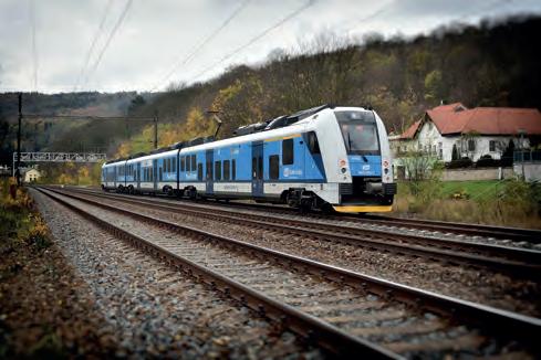
Hexagon’s Safety, Infrastructure & Geospatial division together with Ness Czech will provide the Czech Railway Administration with a Digital Technical Railway Map (DTRM). This railway-specific GIS solution will give the state organization access to information about its transport and technical infrastructure, allowing for more efficient preparation of investments and repair work. The DTRM is based on the Technical Map Information System (ISTEM), developed by both Hexagon and Ness Czech to enhance the management of the railway infrastructure. The Czech Railway Administration, as a railway operator, needs precise information about the railway network and surrounding area. By acquiring accurate and detailed geodetic measurements and digitizing asset and infrastructure information, the Railway Administration can meet its own needs and those of the state, which is developing the Digital Technical Map of the Czech Republic, a national map which should be operational in 2024.
Vexcel upgrades UltraMap software with advanced water handling features
Vexcel Imaging has released a new version of its all-in-one photogrammetric software suite UltraMap, with sophisticated and best-inclass water handling features, enhanced Ortho module performance and a redesigned ortho reprocessing workflow. UltraMap v6.0 introduces True Pixel Processing (TPP), a proprietary raw data processing approach in the Essentials module and supports professional data production for the recently launched UltraCam Eagle 4.1. The new highly automated features for water handling are enhancing the quality of nearly every product throughout the workflow. This includes tools like the new Water Mask & Geometry Editor to efficiently quality-control and edit water masks as well as the updated Seamline & Blending Mask Editor for intuitive generation of homogenous water surfaces in orthomosaics. With UltraMap version 6.0, customers obtain highly accurate, more robust and automatically generated DSM and DTM results plus seamless orthomosaics over land and water for any project size. In addition, performance for most efficient large-scale data production has been optimized by introducing more effective file management, leading to faster loading times, viewing speeds, saving and export of products in the Ortho Viewer.

Lidar survey unveils Taranaki region’s 3D landscape
A new, high-tech aerial laser survey project has been completed in the New Zealand region of Taranaki, producing an exact 3D map of the region’s land surface. The survey, conducted by Toitu Te Whenua Land Information New Zealand (LINZ) in partnership with the Taranaki Regional Council, will provide valuable data for a variety of uses. The data is set to be used to generate highdefinition 3D maps and models that will be used for applications including environmental management and planning, natural hazard management, and infrastructure and service planning. Additionally, the data will be used to track changes to the coastline and river channels. Bjorn Johns, LINZ technical leader, Imagery and Elevation, explained that the dataset was two years in the making. “It’s exciting that we now have accurate elevation information, right down to the property scale, for the entire Taranaki region. The new digital elevation data provides certainty to councils and landowners and ensures their terrain modelling is as accurate as possible.”
Digital twin of Kaunas stretches from campus to Old Town
Kaunas, Lithuania’s second-largest city, is leveraging a digital twin model to help with city planning. This 3D model uses data from the city infrastructure, such as traffic and weather, to assess how changes in the city will affect its citizens. It is also being used to generate simulations of what the city could look like under various scenarios. The digital twin model is set to provide a deeper understanding of the city and helping Kaunas prepare for the future. As laid out in Lithuania’s long-term renovation strategy, approved in 2021, all roughly 660,000 structures must be updated to improve energy performance by 2050. This plan is in line with the European Union’s 2018 directive to address the energy performance of aging buildings and infrastructure, including the decarbonization of the national building stock. With this use case in mind, the Centre for Smart Cities and Infrastructure at Kaunas University of Technology (KTU) has created the Kaunas City digital twin, a digitization of the built environment on the university campus. The digital twin also stretches beyond the campus, offering 3D visualization of the Old Town district in Kaunas.


